
NASA
NASA Webb, Hubble Reveal History of Relic of Milky Way’s Formation
- Webb
- News
- Overview
- Science
- Observatory
- Multimedia
- Team
- More
Image: NASA, ESA, CSA, STScI, Giorgia Zullo (University of Bologna), Francesco Ferraro (University of Bologna); Image Processing: Alyssa Pagan (STScI)
Researchers using two of humanity’s most powerful observatories — NASA’s James Webb and Hubble Space Telescopes — have definitively shown that Terzan 5 is not a globular star cluster as it was once classified, offering new insight into how galaxies like our own form and evolve over time. A globular star cluster typically has only one ancient star population. New data not only confirms the existence of two distinct populations of stars in Terzan 5, but also provides evidence for two more recent rounds of star formation. Although located within the crowded bulge of our Milky Way, our galaxy’s central, spherical region of older stars, Terzan 5 was massive enough to maintain its separate identity while lighter weight systems spread out and mixed to form the bulge billions of years ago. It’s like a lump in an otherwise well-mixed cake batter.
“Webb’s new near-infrared observations, cross-referenced with Hubble’s archival observations, have given us a much clearer picture of the history of Terzan 5,” said Giorgia Zullo, who led the research and is a PhD student at the University of Bologna in Italy.
These results were presented at a press conference Tuesday at the 248th meeting of the American Astronomical Society in Pasadena, and were published in Astronomy & Astrophysics.
Image: Bulge Fossil Fragment Terzan 5 (Webb and Hubble Image) New observations from Webb combined with multiple observations from Hubble prove that Terzan 5 is a self-contained, self-enriching stellar system that contains up to four distinct star populations. It orbits within our Milky Way galaxy’s central bulge. Image: NASA, ESA, CSA, STScI, Giorgia Zullo (University of Bologna), Francesco Ferraro (University of Bologna); Image Processing: Alyssa Pagan (STScI) Four generations of starsDiscovered in 1968 by astronomer Azop Terzan, Terzan 5 resembles a globular cluster in many ways. However, in 2009 this system was discovered to harbor two distinct populations of stars. In 2016 Hubble provided the first estimate of their ages, showing that one formed roughly 12 billion years ago — as the Milky Way itself was assembling — and the other about 5 billion years ago, just before Earth started forming. This pointed to a more complex history than a typical globular cluster.
Studying Terzan 5 is complicated by its location in a region of our galaxy crowded with stars and heavily obscured by dust. This is where Webb stepped in. Its infrared view allowed the research team to peer through the dust and catalog many more stars, and fainter stars, than previous work. By measuring star colors and brightnesses, astronomers can classify them into populations of different ages and chemistries.
Webb was able to measure these key properties for every star within the field of view in the sky — both stars within Terzan 5 and unrelated foreground stars. To isolate the stars of Terzan 5, the team relied on the power and longevity of Hubble. The 12-year separation allowed the team to measure very small movements of individual stars, known as proper motions, to determine which stars belong to Terzan 5 and which are part of the Milky Way bulge.
By combining data from both Webb and Hubble, the researchers found strong evidence for two more stellar populations, one that formed 3.8 billion years ago and another only 2.5 billion years ago. They also were able to determine the ages of the previously known stellar populations with unprecedented precision, finding that they formed 12.5 billion and 4.7 billion years ago.
With the previously known two generations of stars, astronomers could not rule out the possibility that Terzan 5 interacted with another object, like a globular cluster or a giant molecular cloud, becoming enriched with new gas and dust that set off a second round of star formation. With four stellar generations, those explanations are ruled out.
Measurements of the stellar composition of Terzan 5 populations made at the W. M. Keck Observatory and European Southern Observatory’s Very Large Telescope also point toward very distinct populations. “Along with the ages of these populations, the cluster preserves a fossil record of progressive enrichment of heavy elements by supernovae,” said co-author R. Michael Rich, a research astronomer at the University of California, Los Angeles.
Terzan 5 formed multiple generations of stars because it was able to retain the necessary raw materials. There is evidence of powerful supernova explosions in Terzan 5 that forged heavier elements that were swept up by subsequent generations of stars. In lighter weight systems, the force of the explosions themselves could have ejected the resulting elements as well as sweeping out leftover gas and dust. The progenitor of Terzan 5 had enough mass to retain those stars’ ejections, allowing new generations of stars to form over billions of years.
‘Bulge fossil fragment’The results show that Terzan 5 is most likely the remnant of a much more massive stellar system that initially formed 12.5 billion years ago. Terzan 5 is extraordinary because it survived — and never merged or fully “mixed in” with the Milky Way’s bulge. “For some reason, this peculiar clump of stars formed separately from the bulge and was not destroyed as the bulge itself formed,” said Francesco R. Ferraro, a professor at the University of Bologna and principal investigator of the Webb observations. “Terzan 5 is what we now call a bulge fossil fragment because it resembles the primordial clumps that contributed to the formation of the bulge.”
To date, there’s one other known cosmic object like Terzan 5. Liller 1 was the second to be reclassified from a globular star cluster to a bulge fossil fragment. It also contains multiple generations of stars. There may be more objects like it. Between 40 to 50 additional globular clusters that orbit within the bulge will be examined by Ferraro’s team to determine if their stellar populations are all the same, like globular clusters, or have several generations, like bulge fossil fragments.
Video: Zoom to See Terzan 5 Near Our Milky Way Galaxy’s BulgeTo view this video please enable JavaScript, and consider upgrading to a web browser that
supports HTML5 video
Ultimately, this research may improve what we know about how the central bulges of galaxies form over hundreds of millions of years. “Based on observations and in-depth simulations, we think that galaxies in the early universe had huge disks of gas that fragmented into clumps and formed stars. These clumps migrated to the center of the galaxies, and many merged to form their bulges,” said Barbara Lanzoni, a co-author and associate professor at the University of Bologna. For example, Webb has turned up several examples of “clumpy” galaxies that were actively forming when the universe was only a few hundred million years old, like the clumps in the Firefly Sparkle galaxy. “Terzan 5 may provide direct evidence that can help explain how bulges formed in galaxies throughout the universe,” Lanzoni said.
The James Webb Space Telescope is the world’s premier space science observatory. Webb is solving mysteries in our solar system, looking beyond to distant worlds around other stars, and probing the mysterious structures and origins of our universe and our place in it. Webb is an international program led by NASA with its partners, ESA (European Space Agency) and CSA (Canadian Space Agency).
The Hubble Space Telescope has been operating for over three decades and continues to make ground-breaking discoveries that shape our fundamental understanding of the universe. Hubble is a project of international cooperation between NASA and ESA (European Space Agency). NASA’s Goddard Space Flight Center in Greenbelt, Maryland, manages the telescope and mission operations. Lockheed Martin Space, based in Denver, also supports mission operations at Goddard. The Space Telescope Science Institute in Baltimore, which is operated by the Association of Universities for Research in Astronomy, conducts Hubble science operations for NASA.
To learn more about Webb, visit:
To learn more about Hubble, visit:
https://science.nasa.gov/hubble
Downloads & Related InformationThe following sections contain links to download this article’s images and videos in all available resolutions followed by related information links, media contacts, and if available, research paper and Spanish translation links.
Related Images & Videos Bulge Fossil Fragment Terzan 5 (Webb and Hubble Image)New observations from Webb combined with multiple observations from Hubble prove that Terzan 5 is a self-contained, self-enriching stellar system that contains up to four distinct star populations. It orbits within our Milky Way galaxy’s central bulge.
Terzan 5 (Webb and Hubble Compass Image)
This image of bulge fossil fragment Terzan 5 was captured by the James Webb and Hubble space telescopes. Webb’s data are from its NIRCam (Near-Infrared Camera) and Hubble’s from its Advanced Camera for Surveys (ACS). The image shows a scale bar, compass arrows, and co…
Zoom to See Terzan 5 Near Our Milky Way Galaxy’s Bulge
Zoom in to Terzan 5, a star cluster that lies within the crowded central region of our Milky Way galaxy known as the bulge. The scene starts with a ground-based image of our Milky Way bulge and zooms in on and circles Terzan 5, ending with the composite image of the star system f…
Related Links
Read more: Hubble’s star clusters
Explore more: ViewSpace | Forms of light: the Cluster Omega Centauri
Watch: Globular Clusters, Stellar Pockets
Watch: Sorting the Stars in Omega Centauri
Webb: News | Images | Science | Home Page
Hubble: News | Images | Science | Home Page
Laura Betz
NASA’s Goddard Space Flight Center
Greenbelt, Maryland
laura.e.betz@nasa.gov
Christine Pulliam
Space Telescope Science Institute
Baltimore, Maryland
Claire Blome
Space Telescope Science Institute
Baltimore, Maryland
Keep Exploring Related Topics James Webb Space Telescope
Webb is the premier observatory of the next decade, serving thousands of astronomers worldwide. It studies every phase in the…
Stars
Galaxies
Galaxies Stories
NASA’s Quantum Lab Aboard Space Station Gets Chilly Upgrade
Astronauts aboard the International Space Station have switched on NASA’s newly upgraded Cold Atom Lab, a one-of-a-kind facility designed to improve how scientists explore the fundamental workings of matter and develop new quantum technologies. By leveraging the unique environment of microgravity in space, the lab can accomplish cutting-edge science impossible to do anywhere else.
Quantum science is the study of matter at the smallest scales, like atoms, electrons, and single particles of light. While it’s easy to imagine atoms as billiard balls bouncing off one another, they also exhibit wave-like behavior, can exist simultaneously in two places at once, and may even pass through one another.
About the size of a minifridge and operated from Earth, the Cold Atom Lab chills atoms to temperatures below minus 459 degrees Fahrenheit (minus 237 degrees Celsius). At this extreme cold, just above absolute zero, atoms form a large quantum object called a Bose‑Einstein condensate, or BEC, a collection of matter waves that is a fifth state of matter beyond solids, liquids, gases, and plasma. This object follows the rules of quantum mechanics despite being much larger than subatomic particles, and the microgravity of low Earth orbit helps make the waves even larger.
“At the coldest temperatures, matter behaves drastically different from anything we have experienced,” said Jason Williams, project scientist for Cold Atom Lab at NASA’s Jet Propulsion Laboratory in Southern California, which built the facility. “The wavelike nature of matter dominates, and ultracold matter can behave in ways that are not only unexpected, but that also enable extremely precise measurements of time, gravity, and motion. The lab has lots of tools — especially with this latest upgrade — to let us probe the nature of the universe.”
The project supports five international teams studying fundamental physics. It also tests the space-readiness of quantum tools that could support future Earth science and space exploration missions.
How it worksThe heart of the Cold Atom Lab is a complex set of instruments called its science module. An upgraded module launched on April 11 as part of a Commercial Resupply Services mission to the space station, enabling new kinds of experiments.
For each experiment, a strip of rubidium or potassium metal is heated to as high as 750 F (400 C) — hot enough to form a gas within the facility’s vacuum chamber. Lasers tuned to specific frequencies are then fired at the gas, draining the energy from these atoms, and cooling them by slowing them down. Once this gas has completed the laser-cooling stage, a magnetic trap captures and holds the gas in place. Through a series of complex techniques, the laboratory reduces an atom cloud’s energy further, bringing it close to a standstill and maximizing its time in microgravity.
While facilities for studying ultracold gases exist on Earth, the Cold Atom Lab can study quantum gases in microgravity for longer periods of time and at even lower temperatures. Conducting these experiments in low gravity allows scientists to study larger quantum waves that also interact for longer times with gravity. To harness these benefits, the Cold Atom Lab essentially shrinks an atom physics lab, typically the size of an entire room filled with lasers and tabletop mirrors, to fit within an experiment rack aboard the space station.
“As the first project to create Bose-Einstein condensates in orbit, we’re demonstrating that we can make quantum technology work reliably in space,” said Ethan Elliott, deputy project scientist for Cold Atom Lab at JPL. “In the previous century, there was a quantum revolution that led to lasers, cellphones, and MRIs for medical imaging. We’re performing quantum 2.0 — direct manipulation of large quantum states — and we hope for similar gains in quantum tech by advancing this science in orbit.”
The latest upgrade is the fourth since the Cold Atom Lab arrived at the space station in 2018. Key improvements include a newly designed magnetic trap that changes the shape of the quantum gas clouds, allowing scientists to test different properties related to their atoms. The upgrade also features redesigned metal strips that act as sources for those gas clouds.
“It’s the closest thing we have to controlling the boundary of the quantum world,” said Kamal Oudrhiri, project manager of Cold Atom Lab at JPL, referring to those low temperatures. “This new upgrade pushes that boundary even further.”
The upgrade, Oudrhiri added, “demonstrates NASA’s ability to maintain U.S. leadership in space-based quantum technologies while maturing future quantum instruments, such as matter-wave interferometers for fundamental physics missions, positioning, navigation, timing, and gravity sensing of Earth, the Moon, and beyond.”
More about Cold Atom LabManaged by Caltech in Pasadena, JPL designed, built, and operates the Cold Atom Lab, which is sponsored by the Biological and Physical Sciences division of NASA’s Science Mission Directorate at the agency’s headquarters in Washington. The division pioneers scientific discovery and enables exploration by using space environments to conduct investigations that are not possible on Earth. Studying biological and physical phenomena under extreme conditions allows researchers to advance the fundamental scientific knowledge required to go farther and stay longer in space, while also benefiting life on Earth.
To learn more about Cold Atom Lab, visit:
https://nasa.gov/cold-atom-laboratory/
Media ContactAndrew Good
Jet Propulsion Laboratory, Pasadena, Calif.
818-393-2433
andrew.c.good@jpl.nasa.gov
2026-039
Explore More 4 min read El Niño Is UnderwaySatellite observations of sea surface height indicated that the 2026 event continued to strengthen in…
Article 7 minutes ago 2 min read Astronaut Jessica Meir Assists With Hardware Updates for NASA’s Cold Atom LabDescription NASA astronaut Jessica Meir inspects optical fibers while installing hardware updates to the agency’s…
Article 1 day ago 3 min read Explore JPL to Take Place Oct. 10, 11 Article 2 days ago Keep Exploring Discover More Topics From NASA Cold Atom LaboratoryAbout the mission The Cold Atom Laboratory launched to the International Space Station in May 2018 and was installed a…
Jet Propulsion Laboratory
International Space Station
Physical Sciences Program
NASA’s Quantum Lab Aboard Space Station Gets Chilly Upgrade
Astronauts aboard the International Space Station have switched on NASA’s newly upgraded Cold Atom Lab, a one-of-a-kind facility designed to improve how scientists explore the fundamental workings of matter and develop new quantum technologies. By leveraging the unique environment of microgravity in space, the lab can accomplish cutting-edge science impossible to do anywhere else.
Quantum science is the study of matter at the smallest scales, like atoms, electrons, and single particles of light. While it’s easy to imagine atoms as billiard balls bouncing off one another, they also exhibit wave-like behavior, can exist simultaneously in two places at once, and may even pass through one another.
About the size of a minifridge and operated from Earth, the Cold Atom Lab chills atoms to temperatures below minus 459 degrees Fahrenheit (minus 237 degrees Celsius). At this extreme cold, just above absolute zero, atoms form a large quantum object called a Bose‑Einstein condensate, or BEC, a collection of matter waves that is a fifth state of matter beyond solids, liquids, gases, and plasma. This object follows the rules of quantum mechanics despite being much larger than subatomic particles, and the microgravity of low Earth orbit helps make the waves even larger.
“At the coldest temperatures, matter behaves drastically different from anything we have experienced,” said Jason Williams, project scientist for Cold Atom Lab at NASA’s Jet Propulsion Laboratory in Southern California, which built the facility. “The wavelike nature of matter dominates, and ultracold matter can behave in ways that are not only unexpected, but that also enable extremely precise measurements of time, gravity, and motion. The lab has lots of tools — especially with this latest upgrade — to let us probe the nature of the universe.”
The project supports five international teams studying fundamental physics. It also tests the space-readiness of quantum tools that could support future Earth science and space exploration missions.
How it worksThe heart of the Cold Atom Lab is a complex set of instruments called its science module. An upgraded module launched on April 11 as part of a Commercial Resupply Services mission to the space station, enabling new kinds of experiments.
For each experiment, a strip of rubidium or potassium metal is heated to as high as 750 F (400 C) — hot enough to form a gas within the facility’s vacuum chamber. Lasers tuned to specific frequencies are then fired at the gas, draining the energy from these atoms, and cooling them by slowing them down. Once this gas has completed the laser-cooling stage, a magnetic trap captures and holds the gas in place. Through a series of complex techniques, the laboratory reduces an atom cloud’s energy further, bringing it close to a standstill and maximizing its time in microgravity.
While facilities for studying ultracold gases exist on Earth, the Cold Atom Lab can study quantum gases in microgravity for longer periods of time and at even lower temperatures. Conducting these experiments in low gravity allows scientists to study larger quantum waves that also interact for longer times with gravity. To harness these benefits, the Cold Atom Lab essentially shrinks an atom physics lab, typically the size of an entire room filled with lasers and tabletop mirrors, to fit within an experiment rack aboard the space station.
“As the first project to create Bose-Einstein condensates in orbit, we’re demonstrating that we can make quantum technology work reliably in space,” said Ethan Elliott, deputy project scientist for Cold Atom Lab at JPL. “In the previous century, there was a quantum revolution that led to lasers, cellphones, and MRIs for medical imaging. We’re performing quantum 2.0 — direct manipulation of large quantum states — and we hope for similar gains in quantum tech by advancing this science in orbit.”
The latest upgrade is the fourth since the Cold Atom Lab arrived at the space station in 2018. Key improvements include a newly designed magnetic trap that changes the shape of the quantum gas clouds, allowing scientists to test different properties related to their atoms. The upgrade also features redesigned metal strips that act as sources for those gas clouds.
“It’s the closest thing we have to controlling the boundary of the quantum world,” said Kamal Oudrhiri, project manager of Cold Atom Lab at JPL, referring to those low temperatures. “This new upgrade pushes that boundary even further.”
The upgrade, Oudrhiri added, “demonstrates NASA’s ability to maintain U.S. leadership in space-based quantum technologies while maturing future quantum instruments, such as matter-wave interferometers for fundamental physics missions, positioning, navigation, timing, and gravity sensing of Earth, the Moon, and beyond.”
More about Cold Atom LabManaged by Caltech in Pasadena, JPL designed, built, and operates the Cold Atom Lab, which is sponsored by the Biological and Physical Sciences division of NASA’s Science Mission Directorate at the agency’s headquarters in Washington. The division pioneers scientific discovery and enables exploration by using space environments to conduct investigations that are not possible on Earth. Studying biological and physical phenomena under extreme conditions allows researchers to advance the fundamental scientific knowledge required to go farther and stay longer in space, while also benefiting life on Earth.
To learn more about Cold Atom Lab, visit:
https://nasa.gov/cold-atom-laboratory/
Media ContactAndrew Good
Jet Propulsion Laboratory, Pasadena, Calif.
818-393-2433
andrew.c.good@jpl.nasa.gov
2026-039
Explore More 2 min read Astronaut Jessica Meir Assists With Hardware Updates for NASA’s Cold Atom LabDescription NASA astronaut Jessica Meir inspects optical fibers while installing hardware updates to the agency’s…
Article 1 day ago 3 min read Explore JPL to Take Place Oct. 10, 11 Article 2 days ago 2 min read NASA Astronauts to Answer Questions from New Jersey Students Article 2 days ago Keep Exploring Discover More Topics From NASA Cold Atom LaboratoryAbout the mission The Cold Atom Laboratory launched to the International Space Station in May 2018 and was installed a…
Jet Propulsion Laboratory
International Space Station
Physical Sciences Program
NASA Uses Machine Learning to Enhance Flash Flood Warnings
Close
To view this video please enable JavaScript, and consider upgrading to a web browser that
supports HTML5 video
Created with support from NASA’s Earth Science Technology Office (ESTO), TACLS leverages machine learning to automatically locate evidence (unusual increases in atmospheric moisture) of impending flash flooding that meteorologists may otherwise miss as they analyze large amounts of data. TACLS flags that evidence, indicates where flash flooding could likely occur, and displays that information via a user-friendly visualization for human analysts to interpret. Those analysts can then decide whether to issue a flash flood warning or weather advisory.
This novel framework for tracking extreme weather events and predicting imminent flash floods operates in near real-time, producing forecasts in as little as fifteen minutes.
“That’s really what we wanted to do, to give meteorologists a tool to help decision making for flash flood warnings,” said Yehuda Bock, Distinguished Researcher at the UCSD Scripps Institution of Oceanography and principal investigator for TACLS.
In simulations testing, TACLS used data from diverse severe weather events—including atmospheric rivers, monsoonal convection, and tropical cyclone remnants—between 2017 and 2023 and successfully captured 93% of the issued flash-flood warnings. Meteorologists from the National Weather Service are currently working to incorporate TACLS into their existing systems for forecasting flash floods in Southern California.
A cyclone makes landfall across the California coast on November 19, 2024. TACLS will help give communities more time to prepare for impending severe weather. Credit: NASAThis learning system has two main components. First, an analytic back-end software suite uses machine learning algorithms to process satellite data and determine areas at risk for flooding. Second, user-friendly visualization software highlights those areas for further analysis by humans.
The ACLS back-end software analyzes data from satellites in the Global Navigation Satellite System (GNSS), a constellation of satellite networks that drive navigation services around the world. Water vapor in the troposphere delays signals from these satellites as they travel to Earth. This signal delay can be analyzed to calculate the amount of water vapor in the atmosphere over a particular location on Earth.
The TACLS analytic back-end software suite features a machine learning model trained using more than 30 years of past GNSS data. This model is an anomaly detector that tracks unusual increases in atmospheric moisture. The model then carefully examines that atmospheric moisture data and determines whether it’s either an artifact (a false feature or distortion in the data) or a transient (a time-sensitive physical event, like heavy precipitation) that requires interpretation by human analysts.
If TACLS determines the data represents a transient, such as an extreme weather event that warrants a flash flood warning, it will forward that data to the TACLS visualization software (MGViz) for further evaluation by humans. The analysts use their judgement and experience to interpret these events and determine whether the flagged data indicates a flash flood is likely, and, if necessary, issue a flash flood warning.
Several past innovations developed at JPL are leveraged by TACLS to process GNSS data and present the results. The analytic back-end software suite incorporates elements from JPL’s Domain-agnostic Outlier Ranking Algorithms program and the Time-series Forecasting, Evaluation, and Deployment program. The TACLS visualizer is based on the Multi-Mission Geographic Information System, originally developed at JPL for NASA’s Mars missions.
The TACLS software binds all these components within a novel system that enhances existing methods to reduce the amount of time it takes for a human analyst to determine whether to issue a flash flood warning.
Both the TACLS software and the data used to train it will be open-source, allowing scientists to either tailor this model in response to their unique research needs or create their own model from scratch.
For additional details, see the entry for this project on NASA TechPort.
Project Lead: Dr. Yehuda Bock, University of California, San Diego.
Sponsoring Organization(s): NASA’s Earth Science Technology Office Advanced Information Systems Technology Program; JPL; NOAA; National Weather Service.
Department of Health and Human Services Digital Stockpile & Manufacturing Response Network Challenge
NASA’s Center of Excellence for Collaborative Innovation (CoECI) assists in the use of crowdsourcing across the federal government. CoECI’s NASA Tournament Lab offers the contract capability to run external crowdsourced challenges on behalf of NASA and other agencies.
Sponsored by the Administration for Strategic Preparedness and Response (ASPR), a division of the U.S. Department of Health and Human Services (HHS), this prize competition seeks forward-thinking solutions to strengthen the nation’s ability to rapidly produce and distribute critical medical supplies during public health emergencies and supply chain disruptions. Through three challenge phases, participants will develop an innovative conceptual systems design using technologies and frameworks that advance the future of resilient medical manufacturing, logistics, and digital coordination capabilities.
Phase 1: Participants will submit:
- 8-page submission paper
- 3-minute Pitch video
- Blueprint supporting the key capabilities and structure of the solution
Submissions will be evaluated per challenge Judging Criteria. Following the Judge evaluation period, up to 8 Finalists will receive a $5,000 prize each and be invited to the hybrid (in-person and virtual) Pitch Event at ASPR headquarters in Washington, DC. Up to 3 Winners from the Pitch Event will receive a $150,000 prize each and be invited to the innovation development phase.
Phase 2: Two developmental milestones will monitor solution development and will include $75,000 additional prizes for each milestone complete (up to $150,000 in total milestone prize payments).
Phase 3: At the end of the development milestone period, up to 3 teams may be invited to the final Live Validation Event to test their solution under applicable real-world simulations and compete for a total prize purse up to $1,100,000.
Total Prizes: Up to $2.04 Million
Challenge Launch: June 15, 2026
Phase 1 Submissions Due: August 28, 2026
For more information, visit: https://www.expeditionhacks.com/challenges/digital-stockpile-challenge
Metrics
Click here to view the FY26 Services Catalog
The catalogs provide service description, chargeback rate, unit of measure, and service level indicators for each NSSC service.
Service Level Agreement (SLA)Click here to view the Service Level Agreement
The SLA provides information about roles, responsibilities, rates, and service level indicators for all NASA Centers. The SLA is negotiated on an annual basis in line with the fiscal year. A single SLA is shared by all NASA Centers and signed by the Associate Administrator, Chief Financial Officer, Chief Information Officer, and the Office of Inspector General. The SLA provides for the delivery of specific services from the NSSC to NASA Centers and Headquarters Operations in the areas of:
- Financial Management
- Procurement
- Human Resources
- Information Technology
- Agency Business Services
*** On-Line Course Management and Training Purchases have been realigned to the OLC &Training Purchases section of the bill in accordance with the realignment of training funds. Center Special Projects have been consolidated into one Special Projects bill with the funding Center identified for each project.***
FY 2026 – Utilization Reports
October 2025
November 2025
December 2025
January 2026
February 2026
March 2026
April 2026
FY 2025 – Utilization Reports
September 2025
August 2025
July 2025
June 2025
May 2025
April 2025
March 2025
February 2025
January 2025
December 2024
November 2024
October 2024
FY 2024 – Utilization Reports
September 2024
August 2024
July 2024
June 2024
May 2024
April 2024
March 2024
February 2024
January 2024
December 2023
November 2023
October 2023
Aurora Australis
Aurora Australis
The aurora australis arcs over Earth during an active solar event in this photograph taken on June 5, 2026, from the International Space Station as it orbited 271 miles above the Indian Ocean southwest of Perth, Australia.
Auroras are colorful, dynamic, and often visually delicate displays of an intricate dance of particles and magnetism between the Sun and Earth called space weather.
Image credit: NASA/Jessica Meir
Nebraska’s Wide, Rolling Domain
- Earth
- Earth Observatory
- Image of the Day
- EO Explorer
- Topics
- More Content
- About
Nebraska’s Wide, Rolling Domain
- Earth
- Earth Observatory
- Image of the Day
- EO Explorer
- Topics
- More Content
- About
Explore JPL to Take Place Oct. 10, 11
Celebrating its 90th anniversary this year, NASA’s Jet Propulsion Laboratory invites the public to its campus at the base of the San Gabriel Mountains in Southern California for an open-house event, Explore JPL. On Oct. 10 and 11, from 9:30 a.m. to 4 p.m. PDT, visitors will get the chance to visit JPL’s most iconic facilities and explore four thematic areas: Missions That Changed the World, Moon to Mars, In Flight, and Makerspace.
Tickets are free but very limited and have gone quickly for past Explore JPL events. They will be available on the Explore JPL webpage at 9 a.m. PDT Saturday, Aug. 29, and will be distributed on a first-come, first-served basis, with a maximum of five tickets per requestor. Orders for more than five tickets may be subject to cancellation. Tickets will be provided for specific time slots and must be reserved for specific names. Attendees will not be admitted to JPL before the designated time printed on their ticket.
A division of Caltech in Pasadena, California, JPL traces its origins to rocket-propulsion development in 1936. By 1958, the lab had built and helped launch America’s first satellite, Explorer 1. That same year, Congress established NASA, and JPL became a part of the agency. Since then, JPL has managed such historic missions as Voyager, Galileo, Cassini, the Mars Exploration Rover program, the Perseverance Mars rover, Europa Clipper, and many more.
Among other highlights, Explore JPL guests will get to:
- Visit JPL’s legendary Space Flight Operations Facility, a National Historic Landmark where engineers send commands and receive data from spacecraft billions of miles away.
- Discover the Spacecraft Assembly Facility and JPL Machine Shop, where precision spacecraft components are crafted.
- See the latest cutting-edge innovations in robotics research, from autonomous lunar rovers to search-and-rescue robots.
- Get up close with full-scale models of the Perseverance Mars rover, Voyager, and Galileo.
- Step inside the Microdevices Laboratory to see how miniature technologies developed there are shaping the future of space exploration and Earth science.
To attend Explore JPL, visitors must have their tickets in hand and anyone age 18 or over must show government-issued identification. Tickets are not transferable and cannot be sold. Children under age 2 do not require a ticket, but experiences at the event are not intended for very young guests.
Visitors may not bring these items to JPL: weapons or explosives of any kind, incendiary devices, glass containers, alcohol, cannabis or illegal drugs, pets (except certified service animals), banners or signs, flags, boom boxes, air horns, musical instruments, and professional camera equipment with detachable telephoto lenses. Use of laser pointers or whistles is not allowed. No bags, backpacks, or hard-sided coolers are permitted, either, except small purses and diaper bags. Drones are not allowed to fly over JPL under any circumstances. Skates, skateboards, scooters, Segways, and bicycles are not permitted inside the event, as the venues are crowded with pedestrians.
Vehicles entering JPL property are subject to inspection. Parking is free.
Follow JPL on Facebook, X, and Instagram.
To get a virtual tour of JPL, visit:
https://www. jpl.nasa.gov/virtual-tour/
Media Contact
JPL-media@jpl.nasa.gov
Jet Propulsion Laboratory
VoyagerVoyager 1 and its twin Voyager 2 are the only spacecraft ever to operate outside the heliosphere, the protective bubble…
Mars 2020: Perseverance RoverNASA’s Mars Perseverance rover seeks signs of ancient life and collects samples of rock and regolith for possible Earth return.
Europa Clipper
Explore JPL to Take Place Oct. 10, 11
Celebrating its 90th anniversary this year, NASA’s Jet Propulsion Laboratory invites the public to its campus at the base of the San Gabriel Mountains in Southern California for an open-house event, Explore JPL. On Oct. 10 and 11, from 9:30 a.m. to 4 p.m. PDT, visitors will get the chance to visit JPL’s most iconic facilities and explore four thematic areas: Missions That Changed the World, Moon to Mars, In Flight, and Makerspace.
Tickets are free but very limited and have gone quickly for past Explore JPL events. They will be available on the Explore JPL webpage at 9 a.m. PDT Sunday, Aug. 29, and will be distributed on a first-come, first-served basis, with a maximum of five tickets per requestor. Orders for more than five tickets may be subject to cancellation. Tickets will be provided for specific time slots and must be reserved for specific names. Attendees will not be admitted to JPL before the designated time printed on their ticket.
A division of Caltech in Pasadena, California, JPL traces its origins to rocket-propulsion development in 1936. By 1958, the lab had built and helped launch America’s first satellite, Explorer 1. That same year, Congress established NASA, and JPL became a part of the agency. Since then, JPL has managed such historic missions as Voyager, Galileo, Cassini, the Mars Exploration Rover program, the Perseverance Mars rover, Europa Clipper, and many more.
Among other highlights, Explore JPL guests will get to:
- Visit JPL’s legendary Space Flight Operations Facility, a National Historic Landmark where engineers send commands and receive data from spacecraft billions of miles away.
- Discover the Spacecraft Assembly Facility and JPL Machine Shop, where precision spacecraft components are crafted.
- See the latest cutting-edge innovations in robotics research, from autonomous lunar rovers to search-and-rescue robots.
- Get up close with full-scale models of the Mars Perseverance rover, Voyager, and Galileo.
- Step inside the Microdevices Laboratory to see how miniature technologies developed there are shaping the future of space exploration and Earth science.
To attend Explore JPL, visitors must have their tickets in hand and anyone age 18 or over must show government-issued identification. Tickets are not transferable and cannot be sold. Children under age 2 do not require a ticket, but experiences at the event are not intended for very young guests.
Visitors may not bring these items to JPL: weapons or explosives of any kind, incendiary devices, glass containers, alcohol, cannabis or illegal drugs, pets (except certified service animals), banners or signs, flags, boom boxes, air horns, musical instruments, and professional camera equipment with detachable telephoto lenses. Use of laser pointers or whistles is not allowed. No bags, backpacks, or hard-sided coolers are permitted, either, except small purses and diaper bags. Drones are not allowed to fly over JPL under any circumstances. Skates, skateboards, scooters, Segways, and bicycles are not permitted inside the event, as the venues are crowded with pedestrians.
Vehicles entering JPL property are subject to inspection. Parking is free.
Follow JPL on Facebook, X, and Instagram.
To get a virtual tour of JPL, visit:
https://www. jpl.nasa.gov/virtual-tour/
Media Contact
JPL-media@jpl.nasa.gov
Jet Propulsion Laboratory
VoyagerVoyager 1 and its twin Voyager 2 are the only spacecraft ever to operate outside the heliosphere, the protective bubble…
Mars 2020: Perseverance RoverNASA’s Mars Perseverance rover seeks signs of ancient life and collects samples of rock and regolith for possible Earth return.
Europa Clipper
NASA’s Chandra Finds Unexpected Fireworks in Aftermath of Stellar Explosions
To view this video please enable JavaScript, and consider upgrading to a web browser that
supports HTML5 video
The aftermath of a supernova, a stellar explosion, is usually a slowly fading cloud of hot gas. So when astronomers pointed NASA’s Chandra X-ray Observatory at the nearby galaxy Messier 83 (M83), they did not expect to find a population of supernova remnants, or the debris from these explosions, showing dramatic changes in their brightness. The new results were presented at the American Astronomical Society meeting in Pasadena, California, and published in The Astrophysical Journal.
The galaxy M83, located about 15 million light-years from Earth, is forming stars at a high rate. Researchers analyzed 14 years of Chandra data of the galaxy, spanning 2000 to 2014.
Using this extensive set of data, the researchers caught surprising variations in the X-ray brightness of sources previously identified as supernova remnants. The researchers expected supernova remnants older than a century or so to fade gradually in X-rays, but not change dramatically in brightness.
The team found that roughly half of the 22 X-ray sources associated with supernova remnants in their sample showed changes in X-ray brightness over the 14-year span of observations — a result that was completely unexpected.
“We knew that individual X-ray sources could vary dramatically,” said Andrea Prestwich, of the Catholic University of America who led the study. “But finding that so many supernova remnants were behaving this way was a real surprise. Something unusual is going on in these objects. Pinpointing the cause remains a challenge, as M83’s distance limits the detail we can observe.”
One of the 22 variable supernova remnants has a straightforward explanation: SN 1957D, the debris from a supernova first observed nearly 70 years ago, is ramming into material surrounding the explosion site, producing the observed X-ray flares. But this cannot explain the rest of the sample. There is no evidence to suggest that all 22 remnants were formed within the last century. Something else must be driving the variability.
The most likely explanation is that the team has uncovered a population of stellar survivors stars that lived through their partner’s destruction in a supernova explosion. In this scenario, each variable X-ray source began as a pair of massive stars orbiting each other. The more massive star collapsed and exploded as a supernova, leaving behind a black hole or ultra-dense neutron star. Its companion survived.
Galaxy M83 in X-ray and Optical Light. X-ray: NASA/CXC/SAO; Optical: NASA/ESA/AURA/STScI, Hubble Heritage Team, W. Blair (STScI/Johns Hopkins University) and R. O’Connell (University of Virginia); Image Processing: NASA/CXC/SAO/A. Jubett, L. Frattare and P. Edmonds“It may be that this galaxy contains a collection of supernova remnants where one massive star survives the supernova and becomes locked into an orbit with a black hole or neutron star,” said co-author Michael McCollough of the Center for Astrophysics | Harvard & Smithsonian (CfA). “The neutron star or black hole can then start pulling material from the massive star’s surface.”
That infalling material is superheated by the intense gravitational pull, producing the X-rays Chandra detects. These types of systems, known as high-mass X-ray binaries (HMXBs), are among the most variable X-ray sources in the universe. Researchers say they may be the cause of the variations seen in M83’s supernova remnants.
Astronomers have known about HMXBs for decades, but the difference with this group in M83 is their connection to supernova remnants. Previously, only a handful of supernova remnants associated with HMXBs had been identified across observations of all galaxies. It is unprecedented to find more than 20 strong candidates in just one galaxy.
The authors found that the variable supernova remnants are in regions with higher concentrations of massive stars than in other parts of the galaxy, increasing the chances of a link between the remnants and HMXBs.
There is another possible explanation: Instead of pulling in material from a companion star, the black hole or neutron star may be recapturing some of the material blasted outward by the original explosion.
“This could be an example of cosmic recycling, where debris from the explosion falls back onto the very object the supernova created,” said co-author Roy Kilgard of Wesleyan University. “And it’s quite possible that both explanations are at play — different sources in our sample may have different origins.”
These results are not unique to M83. A follow-up study of the nearby star-forming galaxy M51 by Zoe Hoiland of Vassar College and Kilgard has uncovered a similar population of variable X-ray sources associated with supernova remnants, suggesting that such systems may be a feature of galaxies undergoing vigorous star formation.
This is a composite image of the galaxy M51 combining data from NASA’s Chandra X-ray Observatory (purple) with optical data (red, green and blue) taken with ground-based telescopes by a team of astrophotographers. A surprisingly high number of X-ray sources associated with supernova remnants in M51 show large changes in brightness, similar to the behavior seen in M83. Chandra X-ray Data: NASA/CXC/SAO; Astrobin/Optical Groundbased: C.Björk, T.Bähnck, S.Donoso, J.Gentillon, A. and D.Grelin, S.Guberski, R. Hall, T.Heuberger, J.Jacks, P.Kent, Br.Meyers, W.Ostling, N.Puig, T.Schaeffer, F.Schöfbänker, M.VasilevThe Chandra data for M83 began with single observations in 2000 and 2001, followed by 10 observations from 2010 to 2011 and another observation in 2014.
NASA’s Marshall Space Flight Center in Huntsville, Alabama, manages the Chandra program. The Smithsonian Astrophysical Observatory’s Chandra X-ray Center controls science operations from Cambridge, Massachusetts, and flight operations from Burlington, Massachusetts.
Visual DescriptionThis release features a composite image of the nearby galaxy Messier 83, and short timelapse videos of two curious supernova remnants hidden inside.
In the composite image, Messier 83, or M83, is shown to have a spiral structure, viewed straight on. At the center is a brilliant white and yellow pool of light. From that light, spiral arms of hot pink cloud corkscrew out in wide, sweeping arches. The galaxy is covered in a faint grey haze, and flecked with red, green, blue, white, and yellow dots.
In an annotated version of the composite image, two tiny dots to our lower right of center are highlighted by white circles. These are two of the supernova remnants being considered by researchers. Each is examined further in a separate timelapse video.
Over a 14-year period from 2000 to 2014, astronomers pointed NASA’s X-ray observatory at the M83 galaxy. They discovered that about half of the X-ray sources believed to be supernova remnants, the aftermath of stellar explosions, were exhibiting dramatic changes in brightness. This result was entirely unexpected.
Those changes in brightness are highlighted in the timelapse videos. In each video, a series of static images flashes by, focused on one of the two X-ray sources once believed to be supernova remnants. In the videos, the X-ray sources appear as bright blue blobs with glowing cores. But in each image, taken months or years apart, the shapes change, as does the intensity of the blue color, and the brightness of the core. By presenting the substantively different images of the same objects one after another in quick succession, short timelapse videos are created.
The most likely explanation for the changes in brightness is that the team has uncovered a population of stellar survivors, stars that lived through an orbiting partner’s destruction in a supernova explosion. Material is being pulled from the surviving star onto the black hole or neutron star that formed in the supernova, a process known to cause rapid changes in X-ray brightness.
Read more from NASA’s Chandra X-ray Observatory
To learn more about NASA’s Chandra mission, visit:
https://science.nasa.gov/chandra
News Media ContactMegan Watzke
Chandra X-ray Center
Cambridge, Mass.
617-496-7998
mwatzke@cfa.harvard.edu
Joel Wallace
Marshall Space Flight Center, Huntsville, Alabama
256-544-0034
joel.w.wallace@nasa.gov
Share
Details Last Updated Jun 16, 2026 Editor Lee Mohon Contact Joel Wallace Location Marshall Space Flight Center Related Terms Explore More 5 min read NASA’s Chandra Discovers Possible Supernova Remnant in Galactic CenterArticle
5 days ago
1 min read Pretty in Pink
Saturn and its rings are prominently shown in this color image, along with three of…
Article
22 years ago
4 min read NASA Connects Little Red Dots with Chandra, Webb
Article
2 months ago
Keep Exploring Discover More Topics From NASA Chandra X-ray Observatory
The Chandra X-ray Observatory is the world’s most powerful X-ray telescope.
James Webb Space Telescope
Webb is the premier observatory of the next decade, serving thousands of astronomers worldwide. It studies every phase in the…
Hubble Space Telescope
Since its 1990 launch, the Hubble Space Telescope has changed our fundamental understanding of the universe.
Universe
NASA’s Chandra Finds Unexpected Fireworks in Aftermath of Stellar Explosions
To view this video please enable JavaScript, and consider upgrading to a web browser that
supports HTML5 video
The aftermath of a supernova, a stellar explosion, is usually a slowly fading cloud of hot gas. So when astronomers pointed NASA’s Chandra X-ray Observatory at the nearby galaxy Messier 83 (M83), they did not expect to find a population of supernova remnants, or the debris from these explosions, showing dramatic changes in their brightness. The new results were presented at the American Astronomical Society meeting in Pasadena, California, and published in The Astrophysical Journal.
The galaxy M83, located about 15 million light-years from Earth, is forming stars at a high rate. Researchers analyzed 14 years of Chandra data of the galaxy, spanning 2000 to 2014.
Using this extensive set of data, the researchers caught surprising variations in the X-ray brightness of sources previously identified as supernova remnants. The researchers expected supernova remnants older than a century or so to fade gradually in X-rays, but not change dramatically in brightness.
The team found that roughly half of the 22 X-ray sources associated with supernova remnants in their sample showed changes in X-ray brightness over the 14-year span of observations — a result that was completely unexpected.
“We knew that individual X-ray sources could vary dramatically,” said Andrea Prestwich, of the Catholic University of America who led the study. “But finding that so many supernova remnants were behaving this way was a real surprise. Something unusual is going on in these objects. Pinpointing the cause remains a challenge, as M83’s distance limits the detail we can observe.”
One of the 22 variable supernova remnants has a straightforward explanation: SN 1957D, the debris from a supernova first observed nearly 70 years ago, is ramming into material surrounding the explosion site, producing the observed X-ray flares. But this cannot explain the rest of the sample. There is no evidence to suggest that all 22 remnants were formed within the last century. Something else must be driving the variability.
The most likely explanation is that the team has uncovered a population of stellar survivors stars that lived through their partner’s destruction in a supernova explosion. In this scenario, each variable X-ray source began as a pair of massive stars orbiting each other. The more massive star collapsed and exploded as a supernova, leaving behind a black hole or ultra-dense neutron star. Its companion survived.
Galaxy M83 in X-ray and Optical Light. X-ray: NASA/CXC/SAO; Optical: NASA/ESA/AURA/STScI, Hubble Heritage Team, W. Blair (STScI/Johns Hopkins University) and R. O’Connell (University of Virginia); Image Processing: NASA/CXC/SAO/A. Jubett, L. Frattare and P. Edmonds“It may be that this galaxy contains a collection of supernova remnants where one massive star survives the supernova and becomes locked into an orbit with a black hole or neutron star,” said co-author Michael McCollough of the Center for Astrophysics | Harvard & Smithsonian (CfA). “The neutron star or black hole can then start pulling material from the massive star’s surface.”
That infalling material is superheated by the intense gravitational pull, producing the X-rays Chandra detects. These types of systems, known as high-mass X-ray binaries (HMXBs), are among the most variable X-ray sources in the universe. Researchers say they may be the cause of the variations seen in M83’s supernova remnants.
Astronomers have known about HMXBs for decades, but the difference with this group in M83 is their connection to supernova remnants. Previously, only a handful of supernova remnants associated with HMXBs had been identified across observations of all galaxies. It is unprecedented to find more than 20 strong candidates in just one galaxy.
The authors found that the variable supernova remnants are in regions with higher concentrations of massive stars than in other parts of the galaxy, increasing the chances of a link between the remnants and HMXBs.
There is another possible explanation: Instead of pulling in material from a companion star, the black hole or neutron star may be recapturing some of the material blasted outward by the original explosion.
“This could be an example of cosmic recycling, where debris from the explosion falls back onto the very object the supernova created,” said co-author Roy Kilgard of Wesleyan University. “And it’s quite possible that both explanations are at play — different sources in our sample may have different origins.”
These results are not unique to M83. A follow-up study of the nearby star-forming galaxy M51 by Zoe Hoiland of Vassar College and Kilgard has uncovered a similar population of variable X-ray sources associated with supernova remnants, suggesting that such systems may be a feature of galaxies undergoing vigorous star formation.
This is a composite image of the galaxy M51 combining data from NASA’s Chandra X-ray Observatory (purple) with optical data (red, green and blue) taken with ground-based telescopes by a team of astrophotographers. A surprisingly high number of X-ray sources associated with supernova remnants in M51 show large changes in brightness, similar to the behavior seen in M83. Chandra X-ray Data: NASA/CXC/SAO; Astrobin/Optical Groundbased: C.Björk, T.Bähnck, S.Donoso, J.Gentillon, A. and D.Grelin, S.Guberski, R. Hall, T.Heuberger, J.Jacks, P.Kent, Br.Meyers, W.Ostling, N.Puig, T.Schaeffer, F.Schöfbänker, M.VasilevThe Chandra data for M83 began with single observations in 2000 and 2001, followed by 10 observations from 2010 to 2011 and another observation in 2014.
NASA’s Marshall Space Flight Center in Huntsville, Alabama, manages the Chandra program. The Smithsonian Astrophysical Observatory’s Chandra X-ray Center controls science operations from Cambridge, Massachusetts, and flight operations from Burlington, Massachusetts.
Visual DescriptionThis release features a composite image of the nearby galaxy Messier 83, and short timelapse videos of two curious supernova remnants hidden inside.
In the composite image, Messier 83, or M83, is shown to have a spiral structure, viewed straight on. At the center is a brilliant white and yellow pool of light. From that light, spiral arms of hot pink cloud corkscrew out in wide, sweeping arches. The galaxy is covered in a faint grey haze, and flecked with red, green, blue, white, and yellow dots.
In an annotated version of the composite image, two tiny dots to our lower right of center are highlighted by white circles. These are two of the supernova remnants being considered by researchers. Each is examined further in a separate timelapse video.
Over a 14-year period from 2000 to 2014, astronomers pointed NASA’s X-ray observatory at the M83 galaxy. They discovered that about half of the X-ray sources believed to be supernova remnants, the aftermath of stellar explosions, were exhibiting dramatic changes in brightness. This result was entirely unexpected.
Those changes in brightness are highlighted in the timelapse videos. In each video, a series of static images flashes by, focused on one of the two X-ray sources once believed to be supernova remnants. In the videos, the X-ray sources appear as bright blue blobs with glowing cores. But in each image, taken months or years apart, the shapes change, as does the intensity of the blue color, and the brightness of the core. By presenting the substantively different images of the same objects one after another in quick succession, short timelapse videos are created.
The most likely explanation for the changes in brightness is that the team has uncovered a population of stellar survivors, stars that lived through an orbiting partner’s destruction in a supernova explosion. Material is being pulled from the surviving star onto the black hole or neutron star that formed in the supernova, a process known to cause rapid changes in X-ray brightness.
Read more from NASA’s Chandra X-ray Observatory
To learn more about NASA’s Chandra mission, visit:
https://science.nasa.gov/chandra
News Media ContactMegan Watzke
Chandra X-ray Center
Cambridge, Mass.
617-496-7998
mwatzke@cfa.harvard.edu
Joel Wallace
Marshall Space Flight Center, Huntsville, Alabama
256-544-0034
joel.w.wallace@nasa.gov
Share
Details Last Updated Jun 15, 2026 Editor Lee Mohon Contact Joel Wallace Location Marshall Space Flight Center Related Terms Explore More 5 min read NASA’s Chandra Discovers Possible Supernova Remnant in Galactic CenterArticle
4 days ago
1 min read Pretty in Pink
Saturn and its rings are prominently shown in this color image, along with three of…
Article
22 years ago
4 min read NASA Connects Little Red Dots with Chandra, Webb
Article
2 months ago
Keep Exploring Discover More Topics From NASA Chandra X-ray Observatory
The Chandra X-ray Observatory is the world’s most powerful X-ray telescope.
James Webb Space Telescope
Webb is the premier observatory of the next decade, serving thousands of astronomers worldwide. It studies every phase in the…
Hubble Space Telescope
Since its 1990 launch, the Hubble Space Telescope has changed our fundamental understanding of the universe.
Universe
NASA Astronauts to Answer Questions from New Jersey Students
Students in New Jersey will hear from NASA astronauts Chris Williams and Jessica Meir as they answer prerecorded STEM questions while aboard the International Space Station.
The Earth-to-space call will begin at 12:05 p.m. EDT, Thursday, June 18, and will stream live on the agency’s Learn With NASA YouTube channel.
This event is hosted by Newton Public Schools in Newton, New Jersey, for students in grades K-12 and members of the community. This unique opportunity aims to deepen understanding of space exploration and enhance awareness of STEM careers.
Media interested in covering the event must RSVP no later than 5 p.m. EDT, Wednesday, June 17, to Dr. Joseph Piccirillo at: 973-383-7392, x4229 or jpiccirillo@newtonnj.org.
For more than 25 years, astronauts have continuously lived and worked aboard the space station, testing technologies, performing science, and developing skills needed to explore farther from Earth. Astronauts communicate with NASA’s Mission Control Center in Houston 24 hours a day through SCaN’s (Space Communications and Navigation) Near Space Network.
Research and technology investigations taking place aboard the space station benefit people on Earth and lay the groundwork for other agency deep space missions. As part of NASA’s Artemis program, the agency will send astronauts to the Moon to prepare for future human exploration of Mars, inspiring the world through discovery in a new Golden Age of innovation and exploration.
For more information on NASA in-flight calls, visit:
Share Details Last Updated Jun 15, 2026 Related Terms
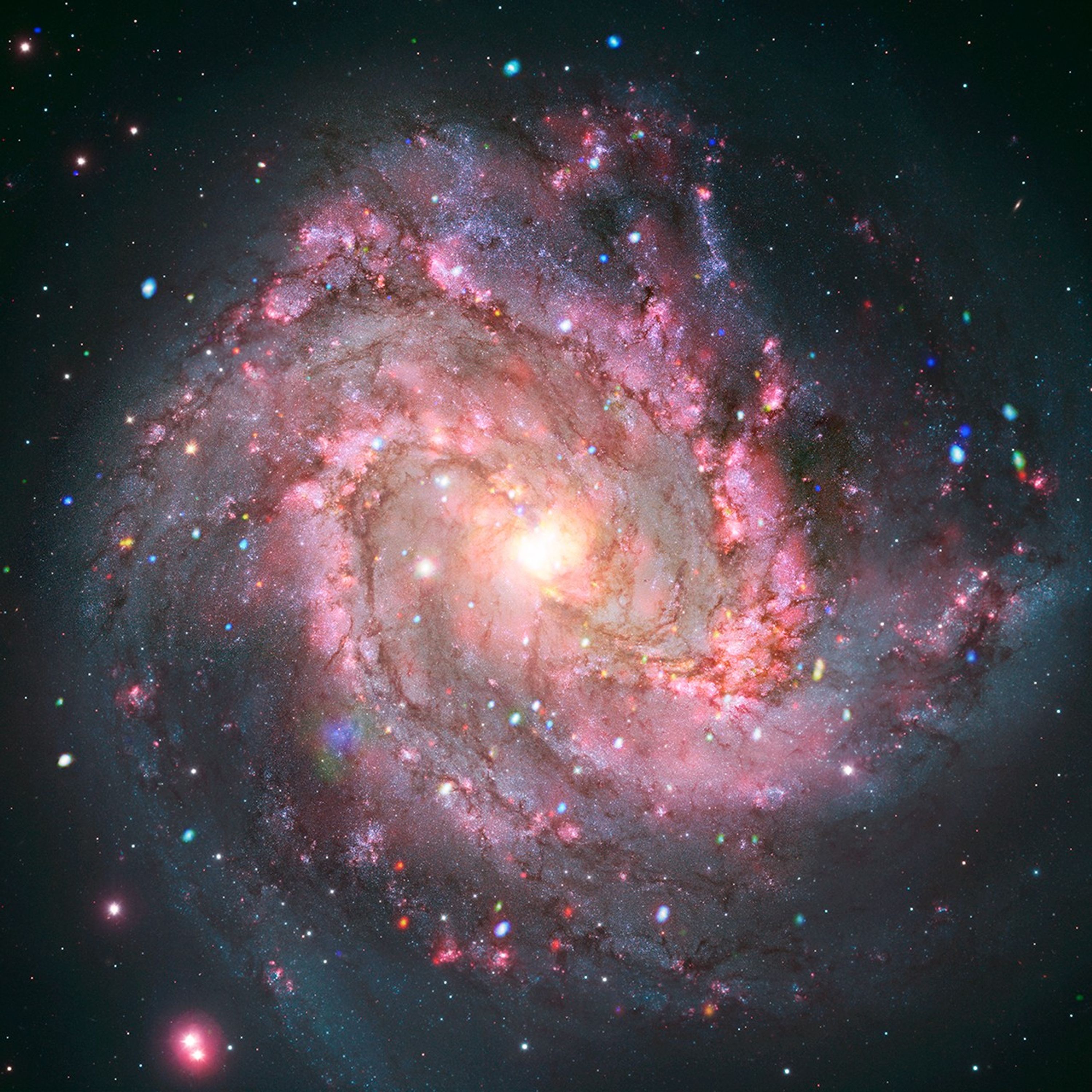
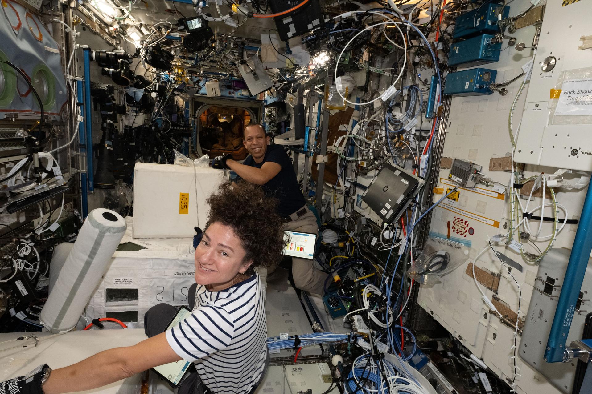