
NASA
Meet the Space Ops Team: Derrick Bailey
3 min read
Preparations for Next Moonwalk Simulations Underway (and Underwater)Since childhood, Derrick Bailey always had an early fascination with aeronautics. Military fighter jet pilots were his childhood heroes, and he dreamed of joining the aerospace industry. This passion was a springboard into his 17-year career at NASA, where Bailey plays an important role in enabling successful rocket launches.
Bailey is the Launch Vehicle Certification Manager in the Launch Services Program (LSP) within the Space Operations Mission Directorate. In this role, he helps NASA outline the agency’s risk classifications of new rockets from emerging and established space companies.
“Within my role, I formulate a series of technical and process assessments for NASA LSP’s technical team to understand how companies operate, how vehicles are designed and qualified, and how they perform in flight,” Bailey said.
Beyond technical proficiency and readiness, a successful rocket launch relies on establishing a strong foundational relationship between NASA and the commercial companies involved. Bailey and his team ensure effective communication with these companies to provide the guidance, data, and analysis necessary to support them in overcoming challenges.
“We work diligently to build trusting relationships with commercial companies and demonstrate the value in partnering with our team,” Bailey said.
Bailey credits a stroke of fate that landed him at the agency. During his senior year at Georgia Tech, where he was pursuing a degree in aerospace engineering, Bailey almost walked past the NASA tent at a career fair. However, he decided to grab a NASA sticker and strike up a conversation, which quickly turned into an impromptu interview. He walked away that day with a job offer to work on the now-retired Space Shuttle Program at the agency’s Kennedy Space Center in Florida.
“I never imagined working at NASA,” Bailey said. “Looking back, it’s unbelievable that a chance encounter resulted in securing a job that has turned into an incredible career.”
Thinking about the future, Bailey is excited about new opportunities in the commercial space industry. Bailey sees NASA as a crucial advisor and mentor for commercial sector while using industry capabilities to provide more cost-effective access to space.
Derrick Bailey, launch vehicle certification manager for NASA’s Launch Services Program“We are the enablers,” Bailey said of his role in the directorate. “It is our responsibility to provide the best opportunity for future explorers to begin their journey of discovery in deep space and beyond.”
Outside of work, Bailey enjoys spending time with his family, especially his two sons, who keep him busy with trips to the baseball diamond and homework sessions. Bailey also enjoys hands-on activities, like working on cars, off-road vehicles, and house projects – hobbies he picked up from his mechanically inclined father. Additionally, at the beginning of 2025, his wife accepted a program specialist position with LSP, an exciting development for the entire Bailey family.
“One of my wife’s major observations early on in my career was how much my colleagues genuinely care about one another and empower people to make decisions,” Bailey explained. “These are the things that make NASA the number one place to work in the government.”
NASA’s Space Operations Mission Directorate maintains a continuous human presence in space for the benefit of people on Earth. The programs within the directorate are the hub of NASA’s space exploration efforts, enabling Artemis, commercial space, science, and other agency missions through communication, launch services, research capabilities, and crew support.
To learn more about NASA’s Space Operation Mission Directorate, visit:
https://www.nasa.gov/directorates/space-operations
Share Details Last Updated Jun 26, 2025 Related Terms Explore More 4 min read NASA to Gather In-Flight Imagery of Commercial Test Capsule Re-Entry Article 1 week ago 4 min read Meet the Space Ops Team: Christine Braden Article 1 month ago 4 min read NASA Enables SPHEREx Data Return Through Commercial Partnership Article 2 months agoMeet the Space Ops Team: Derrick Bailey
3 min read
Preparations for Next Moonwalk Simulations Underway (and Underwater)Since childhood, Derrick Bailey always had an early fascination with aeronautics. Military fighter jet pilots were his childhood heroes, and he dreamed of joining the aerospace industry. This passion was a springboard into his 17-year career at NASA, where Bailey plays an important role in enabling successful rocket launches.
Bailey is the Launch Vehicle Certification Manager in the Launch Services Program (LSP) within the Space Operations Mission Directorate. In this role, he helps NASA outline the agency’s risk classifications of new rockets from emerging and established space companies.
“Within my role, I formulate a series of technical and process assessments for NASA LSP’s technical team to understand how companies operate, how vehicles are designed and qualified, and how they perform in flight,” Bailey said.
Beyond technical proficiency and readiness, a successful rocket launch relies on establishing a strong foundational relationship between NASA and the commercial companies involved. Bailey and his team ensure effective communication with these companies to provide the guidance, data, and analysis necessary to support them in overcoming challenges.
“We work diligently to build trusting relationships with commercial companies and demonstrate the value in partnering with our team,” Bailey said.
Bailey credits a stroke of fate that landed him at the agency. During his senior year at Georgia Tech, where he was pursuing a degree in aerospace engineering, Bailey almost walked past the NASA tent at a career fair. However, he decided to grab a NASA sticker and strike up a conversation, which quickly turned into an impromptu interview. He walked away that day with a job offer to work on the now-retired Space Shuttle Program at the agency’s Kennedy Space Center in Florida.
“I never imagined working at NASA,” Bailey said. “Looking back, it’s unbelievable that a chance encounter resulted in securing a job that has turned into an incredible career.”
Thinking about the future, Bailey is excited about new opportunities in the commercial space industry. Bailey sees NASA as a crucial advisor and mentor for commercial sector while using industry capabilities to provide more cost-effective access to space.
Derrick Bailey, launch vehicle certification manager for NASA’s Launch Services Program“We are the enablers,” Bailey said of his role in the directorate. “It is our responsibility to provide the best opportunity for future explorers to begin their journey of discovery in deep space and beyond.”
Outside of work, Bailey enjoys spending time with his family, especially his two sons, who keep him busy with trips to the baseball diamond and homework sessions. Bailey also enjoys hands-on activities, like working on cars, off-road vehicles, and house projects – hobbies he picked up from his mechanically inclined father. Additionally, at the beginning of 2025, his wife accepted a program specialist position with LSP, an exciting development for the entire Bailey family.
“One of my wife’s major observations early on in my career was how much my colleagues genuinely care about one another and empower people to make decisions,” Bailey explained. “These are the things that make NASA the number one place to work in the government.”
NASA’s Space Operations Mission Directorate maintains a continuous human presence in space for the benefit of people on Earth. The programs within the directorate are the hub of NASA’s space exploration efforts, enabling Artemis, commercial space, science, and other agency missions through communication, launch services, research capabilities, and crew support.
To learn more about NASA’s Space Operation Mission Directorate, visit:
https://www.nasa.gov/directorates/space-operations
Share Details Last Updated Jun 26, 2025 Related Terms Explore More 4 min read NASA to Gather In-Flight Imagery of Commercial Test Capsule Re-Entry Article 1 week ago 4 min read Meet the Space Ops Team: Christine Braden Article 1 month ago 4 min read NASA Enables SPHEREx Data Return Through Commercial Partnership Article 2 months agoNASA’s Webb Digs into Structural Origins of Disk Galaxies
- Webb
- News
- Overview
- Science
- Observatory
- Multimedia
- Team
- More
NASA, ESA, CSA, T. Tsukui (Australian National University).
Present-day disk galaxies often contain a thick, star-filled outer disk and an embedded thin disk of stars. For instance, our own Milky Way galaxy’s thick disk is approximately 3,000 light-years in height, and its thin disk is roughly 1,000 light-years thick.
How and why does this dual disk structure form? By analyzing archival data from multiple observational programs by NASA’s James Webb Space Telescope, a team of astronomers is closer to answers, as well as understanding the origins of disk galaxies in general.
The team carefully identified, visually verified, and analyzed a statistical sample of 111 edge-on disk galaxies at various periods — up to 11 billion years ago (or approximately 2.8 billion years after the big bang). This is the first time scientists have investigated thick- and thin-disk structures spanning such vast distances, bridging the gap between observers probing the early universe and galactic archaeologists seeking to understand our own galaxy’s history.
“This unique measurement of the thickness of the disks at high redshift, or at times in the early universe, is a benchmark for theoretical study that was only possible with Webb,” said Takafumi Tsukui, lead author of the paper and a researcher at the Australian National University in Canberra. “Usually, the older, thick disk stars are faint, and the young, thin disk stars outshine the entire galaxy. But with Webb’s resolution and unique ability to see through dust and highlight faint old stars, we can identify the two-disk structure of galaxies and measure their thickness separately.”
Image: A Sample of Galaxy Disks (NIRCam) Astronomers pulled from NASA’s James Webb Space Telescope’s data to analyze a sample of 111 edge-on galaxies. The team’s analysis suggests that thick disk formation occurs first, and thin disk formation follows. When this process occurs depends on the galaxy’s mass. NASA, ESA, CSA, T. Tsukui (Australian National University). Data Through Thick and ThinBy analyzing these 111 targets over cosmological time, the team was able to study single-disk galaxies and double-disk galaxies. Their results indicate that galaxies form a thick disk first, followed by a thin disk. The timing of when this takes place is dependent on the galaxy’s mass: high-mass, single-disk galaxies transitioned to two-disk structures around 8 billion years ago. In contrast, low-mass, single-disk galaxies formed their embedded thin disks later on, about 4 billion years ago.
“This is the first time it has been possible to resolve thin stellar disks at higher redshift. What’s really novel is uncovering when thin stellar disks start to emerge,” said Emily Wisnioski, a co-author of the paper at the Australian National University in Canberra. “To see thin stellar disks already in place 8 billion years ago, or even earlier, was surprising.”
A Turbulent Time for GalaxiesTo explain this transition from a single, thick disk to a thick and thin disk, and the difference in timing for high- and low-mass galaxies, the team looked beyond their initial edge-on galaxy sample and examined data showing gas in motion from the Atacama Large Millimeter/submillimeter Array (ALMA) and ground-based surveys.
By taking into consideration the motion of the galaxies’ gas disks, the team finds their results align with the “turbulent gas disk” scenario, one of three major hypotheses that has been proposed to explain the process of thick- and thin-disk formation. In this scenario, a turbulent gas disk in the early universe sparks intense star formation, forming a thick stellar disk. As stars form, they stabilize the gas disk, which becomes less turbulent and, as a result, thinner.
Since massive galaxies can more efficiently convert gas into stars, they settle sooner than their low-mass counterparts, resulting in the earlier formation of thin disks. The team notes that thick- and thin-disk formation are not siloed events: The thick disk continues to grow as the galaxy develops, though it’s slower than the thin disk’s rate of growth.
How This Applies to HomeWebb’s sensitivity is enabling astronomers to observe smaller and fainter galaxies, analogous to our own, at early times and with unprecedented clarity for the first time. In this study, the team noted that the transition period from thick disk to a thick and thin disk roughly coincides with the formation of the Milky Way galaxy’s thin disk. With Webb, astronomers will be able to further investigate Milky Way-like progenitors — galaxies that would have preceded the Milky Way — which could help explain our galaxy’s formation history.
In the future, the team intends to incorporate other data points into their edge-on galaxy sample.
“While this study structurally distinguishes thin and thick disks, there is still much more we would like to explore,” said Tsukui. “We want to add the type of information people usually get for nearby galaxies, like stellar motion, age, and metallicity. By doing so, we can bridge the insights from galaxies near and far, and refine our understanding of disk formation.”
These results were published in the Monthly Notices of the Royal Astronomical Society.
The James Webb Space Telescope is the world’s premier space science observatory. Webb is solving mysteries in our solar system, looking beyond to distant worlds around other stars, and probing the mysterious structures and origins of our universe and our place in it. Webb is an international program led by NASA with its partners, ESA (European Space Agency) and CSA (Canadian Space Agency).
To learn more about Webb, visit:
DownloadsClick any image to open a larger version.
View/Download all image products at all resolutions for this article from the Space Telescope Science Institute.
View/Download the research results from the Monthly Notices of the Royal Astronomical Society.
Media ContactsLaura Betz – laura.e.betz@nasa.gov
NASA’s Goddard Space Flight Center, Greenbelt, Md.
Abigail Major – amajor@stsci.edu
Space Telescope Science Institute, Baltimore, Md.
Hannah Braun – hbraun@stsci.edu
Space Telescope Science Institute, Baltimore, Md.
Article: Types of Galaxies
Video: Celestial Tour: Different types of galaxies
Article: Learn more about Webb’s views of nearby spiral galaxies
Visualization Video: Galaxy Traverse
Related For Kids En Español Keep Exploring Related Topics James Webb Space TelescopeWebb is the premier observatory of the next decade, serving thousands of astronomers worldwide. It studies every phase in the…
Galaxies
Galaxies Stories
Universe
Share Details Last Updated Jun 26, 2025 Editor Marty McCoy Contact Laura Betz laura.e.betz@nasa.gov Related Terms
NASA’s Webb Digs into Structural Origins of Disk Galaxies
- Webb
- News
- Overview
- Science
- Observatory
- Multimedia
- Team
- More
NASA, ESA, CSA, T. Tsukui (Australian National University).
Present-day disk galaxies often contain a thick, star-filled outer disk and an embedded thin disk of stars. For instance, our own Milky Way galaxy’s thick disk is approximately 3,000 light-years in height, and its thin disk is roughly 1,000 light-years thick.
How and why does this dual disk structure form? By analyzing archival data from multiple observational programs by NASA’s James Webb Space Telescope, a team of astronomers is closer to answers, as well as understanding the origins of disk galaxies in general.
The team carefully identified, visually verified, and analyzed a statistical sample of 111 edge-on disk galaxies at various periods — up to 11 billion years ago (or approximately 2.8 billion years after the big bang). This is the first time scientists have investigated thick- and thin-disk structures spanning such vast distances, bridging the gap between observers probing the early universe and galactic archaeologists seeking to understand our own galaxy’s history.
“This unique measurement of the thickness of the disks at high redshift, or at times in the early universe, is a benchmark for theoretical study that was only possible with Webb,” said Takafumi Tsukui, lead author of the paper and a researcher at the Australian National University in Canberra. “Usually, the older, thick disk stars are faint, and the young, thin disk stars outshine the entire galaxy. But with Webb’s resolution and unique ability to see through dust and highlight faint old stars, we can identify the two-disk structure of galaxies and measure their thickness separately.”
Image: A Sample of Galaxy Disks (NIRCam) Astronomers pulled from NASA’s James Webb Space Telescope’s data to analyze a sample of 111 edge-on galaxies. The team’s analysis suggests that thick disk formation occurs first, and thin disk formation follows. When this process occurs depends on the galaxy’s mass. NASA, ESA, CSA, T. Tsukui (Australian National University). Data Through Thick and ThinBy analyzing these 111 targets over cosmological time, the team was able to study single-disk galaxies and double-disk galaxies. Their results indicate that galaxies form a thick disk first, followed by a thin disk. The timing of when this takes place is dependent on the galaxy’s mass: high-mass, single-disk galaxies transitioned to two-disk structures around 8 billion years ago. In contrast, low-mass, single-disk galaxies formed their embedded thin disks later on, about 4 billion years ago.
“This is the first time it has been possible to resolve thin stellar disks at higher redshift. What’s really novel is uncovering when thin stellar disks start to emerge,” said Emily Wisnioski, a co-author of the paper at the Australian National University in Canberra. “To see thin stellar disks already in place 8 billion years ago, or even earlier, was surprising.”
A Turbulent Time for GalaxiesTo explain this transition from a single, thick disk to a thick and thin disk, and the difference in timing for high- and low-mass galaxies, the team looked beyond their initial edge-on galaxy sample and examined data showing gas in motion from the Atacama Large Millimeter/submillimeter Array (ALMA) and ground-based surveys.
By taking into consideration the motion of the galaxies’ gas disks, the team finds their results align with the “turbulent gas disk” scenario, one of three major hypotheses that has been proposed to explain the process of thick- and thin-disk formation. In this scenario, a turbulent gas disk in the early universe sparks intense star formation, forming a thick stellar disk. As stars form, they stabilize the gas disk, which becomes less turbulent and, as a result, thinner.
Since massive galaxies can more efficiently convert gas into stars, they settle sooner than their low-mass counterparts, resulting in the earlier formation of thin disks. The team notes that thick- and thin-disk formation are not siloed events: The thick disk continues to grow as the galaxy develops, though it’s slower than the thin disk’s rate of growth.
How This Applies to HomeWebb’s sensitivity is enabling astronomers to observe smaller and fainter galaxies, analogous to our own, at early times and with unprecedented clarity for the first time. In this study, the team noted that the transition period from thick disk to a thick and thin disk roughly coincides with the formation of the Milky Way galaxy’s thin disk. With Webb, astronomers will be able to further investigate Milky Way-like progenitors — galaxies that would have preceded the Milky Way — which could help explain our galaxy’s formation history.
In the future, the team intends to incorporate other data points into their edge-on galaxy sample.
“While this study structurally distinguishes thin and thick disks, there is still much more we would like to explore,” said Tsukui. “We want to add the type of information people usually get for nearby galaxies, like stellar motion, age, and metallicity. By doing so, we can bridge the insights from galaxies near and far, and refine our understanding of disk formation.”
These results were published in the Monthly Notices of the Royal Astronomical Society.
The James Webb Space Telescope is the world’s premier space science observatory. Webb is solving mysteries in our solar system, looking beyond to distant worlds around other stars, and probing the mysterious structures and origins of our universe and our place in it. Webb is an international program led by NASA with its partners, ESA (European Space Agency) and CSA (Canadian Space Agency).
To learn more about Webb, visit:
DownloadsClick any image to open a larger version.
View/Download all image products at all resolutions for this article from the Space Telescope Science Institute.
View/Download the research results from the Monthly Notices of the Royal Astronomical Society.
Media ContactsLaura Betz – laura.e.betz@nasa.gov
NASA’s Goddard Space Flight Center, Greenbelt, Md.
Abigail Major – amajor@stsci.edu
Space Telescope Science Institute, Baltimore, Md.
Hannah Braun – hbraun@stsci.edu
Space Telescope Science Institute, Baltimore, Md.
Article: Types of Galaxies
Video: Celestial Tour: Different types of galaxies
Article: Learn more about Webb’s views of nearby spiral galaxies
Visualization Video: Galaxy Traverse
Related For Kids En Español Keep Exploring Related Topics James Webb Space TelescopeWebb is the premier observatory of the next decade, serving thousands of astronomers worldwide. It studies every phase in the…
Galaxies
Galaxies Stories
Universe
Share Details Last Updated Jun 26, 2025 Editor Marty McCoy Contact Laura Betz laura.e.betz@nasa.gov Related Terms
NASA, Australia Team Up for Artemis II Lunar Laser Communications Test
As NASA prepares for its Artemis II mission, researchers at the agency’s Glenn Research Center in Cleveland are collaborating with The Australian National University (ANU) to prove inventive, cost-saving laser communications technologies in the lunar environment.
Communicating in space usually relies on radio waves, but NASA is exploring laser, or optical, communications, which can send data 10 to 100 times faster to the ground. Instead of radio signals, these systems use infrared light to transmit high-definition video, picture, voice, and science data across vast distances in less time. NASA has proven laser communications during previous technology demonstrations, but Artemis II will be the first crewed mission to attempt using lasers to transmit data from deep space.
To support this effort, researchers working on the agency’s Real Time Optical Receiver (RealTOR) project have developed a cost-effective laser transceiver using commercial-off-the-shelf parts. Earlier this year, NASA Glenn engineers built and tested a replica of the system at the center’s Aerospace Communications Facility, and they are now working with ANU to build a system with the same hardware models to prepare for the university’s Artemis II laser communications demo.
“Australia’s upcoming lunar experiment could showcase the capability, affordability, and reproducibility of the deep space receiver engineered by Glenn,” said Jennifer Downey, co-principal investigator for the RealTOR project at NASA Glenn. “It’s an important step in proving the feasibility of using commercial parts to develop accessible technologies for sustainable exploration beyond Earth.”
During Artemis II, which is scheduled for early 2026, NASA will fly an optical communications system aboard the Orion spacecraft, which will test using lasers to send data across the cosmos. During the mission, NASA will attempt to transmit recorded 4K ultra-high-definition video, flight procedures, pictures, science data, and voice communications from the Moon to Earth.
Nearly 10,000 miles from Cleveland, ANU researchers working at the Mount Stromlo Observatory ground station hope to receive data during Orion’s journey around the Moon using the Glenn-developed transceiver model. This ground station will serve as a test location for the new transceiver design and will not be one of the mission’s primary ground stations. If the test is successful, it will prove that commercial parts can be used to build affordable, scalable space communication systems for future missions to the Moon, Mars, and beyond.
“Engaging with The Australian National University to expand commercial laser communications offerings across the world will further demonstrate how this advanced satellite communications capability is ready to support the agency’s networks and missions as we set our sights on deep space exploration,” said Marie Piasecki, technology portfolio manager for NASA’s Space Communications and Navigation (SCaN) Program.
As NASA continues to investigate the feasibility of using commercial parts to engineer ground stations, Glenn researchers will continue to provide critical support in preparation for Australia’s demonstration.
Strong global partnerships advance technology breakthroughs and are instrumental as NASA expands humanity’s reach from the Moon to Mars, while fueling innovations that improve life on Earth. Through Artemis, NASA will send astronauts to explore the Moon for scientific discovery, economic benefits, and build the foundation for the first crewed missions to Mars.
The RealTOR project is one aspect of the optical communications portfolio within NASA’s SCaN Program, which includes demonstrations and in-space experiment platforms to test the viability of infrared light for sending data to and from space. These include the LCOT (Low-Cost Optical Terminal) project, the Laser Communications Relay Demonstration, and more. NASA Glenn manages the project under the direction of agency’s SCaN Program at NASA Headquarters in Washington.
The Australian National University’s demonstration is supported by the Australian Space Agency Moon to Mars Demonstrator Mission Grant program, which has facilitated operational capability for the Australian Deep Space Optical Ground Station Network.
To learn how space communications and navigation capabilities support every agency mission, visit:
https://www.nasa.gov/communicating-with-missions
Explore More 3 min read NASA Engineers Simulate Lunar Lighting for Artemis III Moon Landing Article 1 week ago 2 min read NASA Seeks Commercial Feedback on Space Communication Solutions Article 2 weeks ago 4 min read NASA, DoD Practice Abort Scenarios Ahead of Artemis II Moon Mission Article 2 weeks agoNASA, Australia Team Up for Artemis II Lunar Laser Communications Test
As NASA prepares for its Artemis II mission, researchers at the agency’s Glenn Research Center in Cleveland are collaborating with The Australian National University (ANU) to prove inventive, cost-saving laser communications technologies in the lunar environment.
Communicating in space usually relies on radio waves, but NASA is exploring laser, or optical, communications, which can send data 10 to 100 times faster to the ground. Instead of radio signals, these systems use infrared light to transmit high-definition video, picture, voice, and science data across vast distances in less time. NASA has proven laser communications during previous technology demonstrations, but Artemis II will be the first crewed mission to attempt using lasers to transmit data from deep space.
To support this effort, researchers working on the agency’s Real Time Optical Receiver (RealTOR) project have developed a cost-effective laser transceiver using commercial-off-the-shelf parts. Earlier this year, NASA Glenn engineers built and tested a replica of the system at the center’s Aerospace Communications Facility, and they are now working with ANU to build a system with the same hardware models to prepare for the university’s Artemis II laser communications demo.
“Australia’s upcoming lunar experiment could showcase the capability, affordability, and reproducibility of the deep space receiver engineered by Glenn,” said Jennifer Downey, co-principal investigator for the RealTOR project at NASA Glenn. “It’s an important step in proving the feasibility of using commercial parts to develop accessible technologies for sustainable exploration beyond Earth.”
During Artemis II, which is scheduled for early 2026, NASA will fly an optical communications system aboard the Orion spacecraft, which will test using lasers to send data across the cosmos. During the mission, NASA will attempt to transmit recorded 4K ultra-high-definition video, flight procedures, pictures, science data, and voice communications from the Moon to Earth.
Nearly 10,000 miles from Cleveland, ANU researchers working at the Mount Stromlo Observatory ground station hope to receive data during Orion’s journey around the Moon using the Glenn-developed transceiver model. This ground station will serve as a test location for the new transceiver design and will not be one of the mission’s primary ground stations. If the test is successful, it will prove that commercial parts can be used to build affordable, scalable space communication systems for future missions to the Moon, Mars, and beyond.
“Engaging with The Australian National University to expand commercial laser communications offerings across the world will further demonstrate how this advanced satellite communications capability is ready to support the agency’s networks and missions as we set our sights on deep space exploration,” said Marie Piasecki, technology portfolio manager for NASA’s Space Communications and Navigation (SCaN) Program.
As NASA continues to investigate the feasibility of using commercial parts to engineer ground stations, Glenn researchers will continue to provide critical support in preparation for Australia’s demonstration.
Strong global partnerships advance technology breakthroughs and are instrumental as NASA expands humanity’s reach from the Moon to Mars, while fueling innovations that improve life on Earth. Through Artemis, NASA will send astronauts to explore the Moon for scientific discovery, economic benefits, and build the foundation for the first crewed missions to Mars.
The RealTOR project is one aspect of the optical communications portfolio within NASA’s SCaN Program, which includes demonstrations and in-space experiment platforms to test the viability of infrared light for sending data to and from space. These include the LCOT (Low-Cost Optical Terminal) project, the Laser Communications Relay Demonstration, and more. NASA Glenn manages the project under the direction of agency’s SCaN Program at NASA Headquarters in Washington.
The Australian National University’s demonstration is supported by the Australian Space Agency Moon to Mars Demonstrator Mission Grant program, which has facilitated operational capability for the Australian Deep Space Optical Ground Station Network.
To learn how space communications and navigation capabilities support every agency mission, visit:
https://www.nasa.gov/communicating-with-missions
Explore More 3 min read NASA Engineers Simulate Lunar Lighting for Artemis III Moon Landing Article 1 week ago 2 min read NASA Seeks Commercial Feedback on Space Communication Solutions Article 1 week ago 4 min read NASA, DoD Practice Abort Scenarios Ahead of Artemis II Moon Mission Article 2 weeks agoNASA’s Chandra Shares a New View of Our Galactic Neighbor
The Andromeda galaxy, also known as Messier 31 (M31), is the closest spiral galaxy to the Milky Way at a distance of about 2.5 million light-years. Astronomers use Andromeda to understand the structure and evolution of our own spiral, which is much harder to do since Earth is embedded inside the Milky Way.
The galaxy M31 has played an important role in many aspects of astrophysics, but particularly in the discovery of dark matter. In the 1960s, astronomer Vera Rubin and her colleagues studied M31 and determined that there was some unseen matter in the galaxy that was affecting how the galaxy and its spiral arms rotated. This unknown material was named “dark matter.” Its nature remains one of the biggest open questions in astrophysics today, one which NASA’s upcoming Nancy Grace Roman Space Telescope is designed to help answer.
X-ray: NASA/CXO/UMass/Z. Li & Q.D. Wang, ESA/XMM-Newton; Infrared: NASA/JPL-Caltech/WISE, Spitzer, NASA/JPL-Caltech/K. Gordon (U. Az), ESA/Herschel, ESA/Planck, NASA/IRAS, NASA/COBE; Radio: NSF/GBT/WSRT/IRAM/C. Clark (STScI); Ultraviolet: NASA/JPL-Caltech/GALEX; Optical: Andromeda, Unexpected © Marcel Drechsler, Xavier Strottner, Yann Sainty & J. Sahner, T. Kottary. Composite image processing: L. Frattare, K. Arcand, J.MajorThis new composite image contains data of M31 taken by some of the world’s most powerful telescopes in different kinds of light. This image includes X-rays from NASA’s Chandra X-ray Observatory and ESA’s (European Space Agency’s) XMM-Newton (represented in red, green, and blue); ultraviolet data from NASA’s retired GALEX (blue); optical data from astrophotographers using ground based telescopes (Jakob Sahner and Tarun Kottary); infrared data from NASA’s retired Spitzer Space Telescope, the Infrared Astronomy Satellite, COBE, Planck, and Herschel (red, orange, and purple); and radio data from the Westerbork Synthesis Radio Telescope (red-orange).
The Andromeda Galaxy (M31) in Different Types of Light.X-ray: NASA/CXO/UMass/Z. Li & Q.D. Wang, ESA/XMM-Newton; Infrared: NASA/JPL-Caltech/WISE, Spitzer, NASA/JPL-Caltech/K. Gordon (U. Az), ESA/Herschel, ESA/Planck, NASA/IRAS, NASA/COBE; Radio: NSF/GBT/WSRT/IRAM/C. Clark (STScI); Ultraviolet: NASA/JPL-Caltech/GALEX; Optical: Andromeda, Unexpected © Marcel Drechsler, Xavier Strottner, Yann Sainty & J. Sahner, T. Kottary. Composite image processing: L. Frattare, K. Arcand, J.MajorEach type of light reveals new information about this close galactic relative to the Milky Way. For example, Chandra’s X-rays reveal the high-energy radiation around the supermassive black hole at the center of M31 as well as many other smaller compact and dense objects strewn across the galaxy. A recent paper about Chandra observations of M31 discusses the amount of X-rays produced by the supermassive black hole in the center of the galaxy over the last 15 years. One flare was observed in 2013, which appears to represent an amplification of the typical X-rays seen from the black hole.
These multi-wavelength datasets are also being released as a sonification, which includes the same wavelengths of data in the new composite. In the sonification, the layer from each telescope has been separated out and rotated so that they stack on top of each other horizontally, beginning with X-rays at the top and then moving through ultraviolet, optical, infrared, and radio at the bottom. As the scan moves from left to right in the sonification, each type of light is mapped to a different range of notes, from lower-energy radio waves up through the high energy of X-rays. Meanwhile, the brightness of each source controls volume, and the vertical location dictates the pitch.
To view this video please enable JavaScript, and consider upgrading to a web browser that supports HTML5 video
In this sonification of M31, the layers from each telescope has been separated out and rotated so that they stack on top of each other horizontally beginning with X-rays at the top and then moving through ultraviolet, optical, infrared, and radio at the bottom. As the scan moves from left to right in the sonification, each type of light is mapped to a different range of notes ranging from lower-energy radio waves up through the high-energy of X-rays. Meanwhile, the brightness of each source controls volume and the vertical location dictates the pitch.NASA/CXC/SAO/K.Arcand, SYSTEM Sounds (M. Russo, A. SantaguidaThis new image of M31 is released in tribute to the groundbreaking legacy of Dr. Vera Rubin, whose observations transformed our understanding of the universe. Rubin’s meticulous measurements of Andromeda’s rotation curve provided some of the earliest and most convincing evidence that galaxies are embedded in massive halos of invisible material — what we now call dark matter. Her work challenged long-held assumptions and catalyzed a new era of research into the composition and dynamics of the cosmos. In recognition of her profound scientific contributions, the United States Mint has recently released a quarter in 2025 featuring Rubin as part of its American Women Quarters Program — making her the first astronomer honored in the series.
NASA’s Marshall Space Flight Center in Huntsville, Alabama, manages the Chandra program. The Smithsonian Astrophysical Observatory’s Chandra X-ray Center controls science operations from Cambridge, Massachusetts, and flight operations from Burlington, Massachusetts.
Read more from NASA’s Chandra X-ray ObservatoryLearn more about the Chandra X-ray Observatory and its mission here:
Visual DescriptionThis release features several images and a sonification video examining the Andromeda galaxy, our closest spiral galaxy neighbor. This collection helps astronomers understand the evolution of the Milky Way, our own spiral galaxy, and provides a fascinating insight into astronomical data gathering and presentation.
Like all spiral galaxies viewed at this distance and angle, Andromeda appears relatively flat. Its spiraling arms circle around a bright core, creating a disk shape, like a large dinner plate. In most of the images in this collection, Andromeda’s flat surface is tilted to face our upper left.
This collection features data from some of the world’s most powerful telescopes, each capturing light in a different spectrum. In each single-spectrum image, Andromeda has a similar shape and orientation, but the colors and details are dramatically different.
In radio waves, the spiraling arms appear red and orange, like a burning, loosely coiled rope. The center appears black, with no core discernible. In infrared light, the outer arms are similarly fiery. Here, a white spiraling ring encircles a blue center with a small golden core. The optical image is hazy and grey, with spiraling arms like faded smoke rings. Here, the blackness of space is dotted with specks of light, and a small bright dot glows at the core of the galaxy. In ultraviolet light the spiraling arms are icy blue and white, with a hazy white ball at the core. No spiral arms are present in the X-ray image, making the bright golden core and nearby stars clear and easy to study.
In this release, the single-spectrum images are presented side by side for easy comparison. They are also combined into a composite image. In the composite, Andromeda’s spiraling arms are the color of red wine near the outer edges, and lavender near the center. The core is large and bright, surrounded by a cluster of bright blue and green specks. Other small flecks in a variety of colors dot the galaxy, and the blackness of space surrounding it.
This release also features a thirty second video, which sonifies the collected data. In the video, the single-spectrum images are stacked vertically, one atop the other. As the video plays, an activation line sweeps across the stacked images from left to right. Musical notes ring out when the line encounters light. The lower the wavelength energy, the lower the pitches of the notes. The brighter the source, the louder the volume.
News Media ContactMegan Watzke
Chandra X-ray Center
Cambridge, Mass.
617-496-7998
mwatzke@cfa.harvard.edu
Lane Figueroa
Marshall Space Flight Center, Huntsville, Alabama
256-544-0034
lane.e.figueroa@nasa.gov
When two stars orbit one another in such a way that one blocks the other’s…
Article 7 hours ago 5 min read NASA’s Webb Digs into Structural Origins of Disk GalaxiesPresent-day disk galaxies often contain a thick, star-filled outer disk and an embedded thin disk…
Article 9 hours agoNASA’s Chandra Shares a New View of Our Galactic Neighbor
The Andromeda galaxy, also known as Messier 31 (M31), is the closest spiral galaxy to the Milky Way at a distance of about 2.5 million light-years. Astronomers use Andromeda to understand the structure and evolution of our own spiral, which is much harder to do since Earth is embedded inside the Milky Way.
The galaxy M31 has played an important role in many aspects of astrophysics, but particularly in the discovery of dark matter. In the 1960s, astronomer Vera Rubin and her colleagues studied M31 and determined that there was some unseen matter in the galaxy that was affecting how the galaxy and its spiral arms rotated. This unknown material was named “dark matter.” Its nature remains one of the biggest open questions in astrophysics today, one which NASA’s upcoming Nancy Grace Roman Space Telescope is designed to help answer.
X-ray: NASA/CXO/UMass/Z. Li & Q.D. Wang, ESA/XMM-Newton; Infrared: NASA/JPL-Caltech/WISE, Spitzer, NASA/JPL-Caltech/K. Gordon (U. Az), ESA/Herschel, ESA/Planck, NASA/IRAS, NASA/COBE; Radio: NSF/GBT/WSRT/IRAM/C. Clark (STScI); Ultraviolet: NASA/JPL-Caltech/GALEX; Optical: Andromeda, Unexpected © Marcel Drechsler, Xavier Strottner, Yann Sainty & J. Sahner, T. Kottary. Composite image processing: L. Frattare, K. Arcand, J.MajorThis new composite image contains data of M31 taken by some of the world’s most powerful telescopes in different kinds of light. This image includes X-rays from NASA’s Chandra X-ray Observatory and ESA’s (European Space Agency’s) XMM-Newton (represented in red, green, and blue); ultraviolet data from NASA’s retired GALEX (blue); optical data from astrophotographers using ground based telescopes (Jakob Sahner and Tarun Kottary); infrared data from NASA’s retired Spitzer Space Telescope, the Infrared Astronomy Satellite, COBE, Planck, and Herschel (red, orange, and purple); and radio data from the Westerbork Synthesis Radio Telescope (red-orange).
The Andromeda Galaxy (M31) in Different Types of Light.X-ray: NASA/CXO/UMass/Z. Li & Q.D. Wang, ESA/XMM-Newton; Infrared: NASA/JPL-Caltech/WISE, Spitzer, NASA/JPL-Caltech/K. Gordon (U. Az), ESA/Herschel, ESA/Planck, NASA/IRAS, NASA/COBE; Radio: NSF/GBT/WSRT/IRAM/C. Clark (STScI); Ultraviolet: NASA/JPL-Caltech/GALEX; Optical: Andromeda, Unexpected © Marcel Drechsler, Xavier Strottner, Yann Sainty & J. Sahner, T. Kottary. Composite image processing: L. Frattare, K. Arcand, J.MajorEach type of light reveals new information about this close galactic relative to the Milky Way. For example, Chandra’s X-rays reveal the high-energy radiation around the supermassive black hole at the center of M31 as well as many other smaller compact and dense objects strewn across the galaxy. A recent paper about Chandra observations of M31 discusses the amount of X-rays produced by the supermassive black hole in the center of the galaxy over the last 15 years. One flare was observed in 2013, which appears to represent an amplification of the typical X-rays seen from the black hole.
These multi-wavelength datasets are also being released as a sonification, which includes the same wavelengths of data in the new composite. In the sonification, the layer from each telescope has been separated out and rotated so that they stack on top of each other horizontally, beginning with X-rays at the top and then moving through ultraviolet, optical, infrared, and radio at the bottom. As the scan moves from left to right in the sonification, each type of light is mapped to a different range of notes, from lower-energy radio waves up through the high energy of X-rays. Meanwhile, the brightness of each source controls volume, and the vertical location dictates the pitch.
To view this video please enable JavaScript, and consider upgrading to a web browser that supports HTML5 video
In this sonification of M31, the layers from each telescope has been separated out and rotated so that they stack on top of each other horizontally beginning with X-rays at the top and then moving through ultraviolet, optical, infrared, and radio at the bottom. As the scan moves from left to right in the sonification, each type of light is mapped to a different range of notes ranging from lower-energy radio waves up through the high-energy of X-rays. Meanwhile, the brightness of each source controls volume and the vertical location dictates the pitch.NASA/CXC/SAO/K.Arcand, SYSTEM Sounds (M. Russo, A. SantaguidaThis new image of M31 is released in tribute to the groundbreaking legacy of Dr. Vera Rubin, whose observations transformed our understanding of the universe. Rubin’s meticulous measurements of Andromeda’s rotation curve provided some of the earliest and most convincing evidence that galaxies are embedded in massive halos of invisible material — what we now call dark matter. Her work challenged long-held assumptions and catalyzed a new era of research into the composition and dynamics of the cosmos. In recognition of her profound scientific contributions, the United States Mint has recently released a quarter in 2025 featuring Rubin as part of its American Women Quarters Program — making her the first astronomer honored in the series.
NASA’s Marshall Space Flight Center in Huntsville, Alabama, manages the Chandra program. The Smithsonian Astrophysical Observatory’s Chandra X-ray Center controls science operations from Cambridge, Massachusetts, and flight operations from Burlington, Massachusetts.
Read more from NASA’s Chandra X-ray ObservatoryLearn more about the Chandra X-ray Observatory and its mission here:
Visual DescriptionThis release features several images and a sonification video examining the Andromeda galaxy, our closest spiral galaxy neighbor. This collection helps astronomers understand the evolution of the Milky Way, our own spiral galaxy, and provides a fascinating insight into astronomical data gathering and presentation.
Like all spiral galaxies viewed at this distance and angle, Andromeda appears relatively flat. Its spiraling arms circle around a bright core, creating a disk shape, like a large dinner plate. In most of the images in this collection, Andromeda’s flat surface is tilted to face our upper left.
This collection features data from some of the world’s most powerful telescopes, each capturing light in a different spectrum. In each single-spectrum image, Andromeda has a similar shape and orientation, but the colors and details are dramatically different.
In radio waves, the spiraling arms appear red and orange, like a burning, loosely coiled rope. The center appears black, with no core discernible. In infrared light, the outer arms are similarly fiery. Here, a white spiraling ring encircles a blue center with a small golden core. The optical image is hazy and grey, with spiraling arms like faded smoke rings. Here, the blackness of space is dotted with specks of light, and a small bright dot glows at the core of the galaxy. In ultraviolet light the spiraling arms are icy blue and white, with a hazy white ball at the core. No spiral arms are present in the X-ray image, making the bright golden core and nearby stars clear and easy to study.
In this release, the single-spectrum images are presented side by side for easy comparison. They are also combined into a composite image. In the composite, Andromeda’s spiraling arms are the color of red wine near the outer edges, and lavender near the center. The core is large and bright, surrounded by a cluster of bright blue and green specks. Other small flecks in a variety of colors dot the galaxy, and the blackness of space surrounding it.
This release also features a thirty second video, which sonifies the collected data. In the video, the single-spectrum images are stacked vertically, one atop the other. As the video plays, an activation line sweeps across the stacked images from left to right. Musical notes ring out when the line encounters light. The lower the wavelength energy, the lower the pitches of the notes. The brighter the source, the louder the volume.
News Media ContactMegan Watzke
Chandra X-ray Center
Cambridge, Mass.
617-496-7998
mwatzke@cfa.harvard.edu
Lane Figueroa
Marshall Space Flight Center, Huntsville, Alabama
256-544-0034
lane.e.figueroa@nasa.gov
When two stars orbit one another in such a way that one blocks the other’s…
Article 12 hours ago 5 min read NASA’s Webb Digs into Structural Origins of Disk GalaxiesPresent-day disk galaxies often contain a thick, star-filled outer disk and an embedded thin disk…
Article 14 hours agoNASA Astronauts to Answer Questions from Alabama Students
Students attending the U.S. Space and Rocket Center Space Camp in Huntsville, Alabama, will have the chance to hear NASA astronauts aboard the International Space Station answer their prerecorded questions.
At 12:40 p.m. EDT on Tuesday, July 1, NASA astronauts Anne McClain, Jonny Kim, and Nichole Ayers will answer student questions. Ayers is a space camp alumna.
Watch the 20-minute Earth-to-space call on the NASA STEM YouTube Channel.
The U.S. Space and Rocket Center will host the downlink while celebrating the 65th anniversary of NASA’s Marshall Space Flight Center. This event is open to the public.
Media interested in covering the event must RSVP by 5 p.m., Friday, June 27, to Pat Ammons at: 256-721-5429 or pat.ammons@spacecamp.com.
For nearly 25 years, astronauts have continuously lived and worked aboard the space station, testing technologies, performing science, and developing skills needed to explore farther from Earth. Astronauts aboard the orbiting laboratory communicate with NASA’s Mission Control Center in Houston 24 hours a day through SCaN’s (Space Communications and Navigation) Near Space Network.
Important research and technology investigations taking place aboard the space station benefit people on Earth and lay the groundwork for other agency missions. As part of NASA’s Artemis campaign, the agency will send astronauts to the Moon to prepare for future human exploration of Mars; inspiring Golden Age explorers and ensuring the United States continues to lead in space exploration and discovery.
See videos of astronauts aboard the space station at:
https://www.nasa.gov/stemonstation
-end-
Gerelle Dodson
Headquarters, Washington
202-358-1600
gerelle.q.dodson@nasa.gov
Sandra Jones
Johnson Space Center, Houston
281-483-5111
sandra.p.jones@nasa.gov
NASA Astronauts to Answer Questions from Alabama Students
Students attending the U.S. Space and Rocket Center Space Camp in Huntsville, Alabama, will have the chance to hear NASA astronauts aboard the International Space Station answer their prerecorded questions.
At 12:40 p.m. EDT on Tuesday, July 1, NASA astronauts Anne McClain, Jonny Kim, and Nichole Ayers will answer student questions. Ayers is a space camp alumna.
Watch the 20-minute Earth-to-space call on the NASA STEM YouTube Channel.
The U.S. Space and Rocket Center will host the downlink while celebrating the 65th anniversary of NASA’s Marshall Space Flight Center. This event is open to the public.
Media interested in covering the event must RSVP by 5 p.m., Friday, June 27, to Pat Ammons at: 256-721-5429 or pat.ammons@spacecamp.com.
For nearly 25 years, astronauts have continuously lived and worked aboard the space station, testing technologies, performing science, and developing skills needed to explore farther from Earth. Astronauts aboard the orbiting laboratory communicate with NASA’s Mission Control Center in Houston 24 hours a day through SCaN’s (Space Communications and Navigation) Near Space Network.
Important research and technology investigations taking place aboard the space station benefit people on Earth and lay the groundwork for other agency missions. As part of NASA’s Artemis campaign, the agency will send astronauts to the Moon to prepare for future human exploration of Mars; inspiring Golden Age explorers and ensuring the United States continues to lead in space exploration and discovery.
See videos of astronauts aboard the space station at:
https://www.nasa.gov/stemonstation
-end-
Gerelle Dodson
Headquarters, Washington
202-358-1600
gerelle.q.dodson@nasa.gov
Sandra Jones
Johnson Space Center, Houston
281-483-5111
sandra.p.jones@nasa.gov
Waning Crescent Moon
Waning Crescent Moon
NASA astronaut Bob Hines took this picture of the waning crescent moon on May 8, 2022, as the International Space Station flew into an orbital sunrise 260 miles above the Atlantic Ocean off the northwest coast of the United States. Since the station became operational in November 2000, crew members have produced hundreds of thousands of images of our Moon and Earth through Crew Earth Observations.
Image credit: NASA/Bob Hines
NASA-Assisted Scientists Get Bird’s-Eye View of Population Status
- Earth
- Explore
- Science at Work
- Multimedia
- Data
- For Researchers
- About Us
4 min read
NASA-Assisted Scientists Get Bird’s-Eye View of Population StatusThrough the eBird citizen scientist program, millions of birders have recorded their observations of different species and submitted checklists to the Cornell Lab of Ornithology. Through a partnership with NASA, the lab has now used this data to model and map bird population trends for nearly 500 North American species.
Led by Alison Johnston of the University of St. Andrews in Scotland, the researchers reported that 75% of bird species in the study are declining at wide-range scales. And yet this study has some good news for birds. The results, published in Science in May, offer insights and projections that could shape the future conservation of the places where birds make their homes.
“This project demonstrates the power of merging in situ data with NASA remote sensing to model biological phenomena that were previously impossible to document,” said Keith Gaddis, NASA’s Biological Diversity and Ecological Forecasting program manager at the agency’s headquarters in Washington, who was not involved in the study. “This data provides not just insight into the Earth system but also provides actionable guidance to land managers to mitigate biodiversity loss.”
Rock wren in Joshua Tree National Park. National Park Service / Jane GambleA team from Cornell, the University of St. Andrews, and the American Bird Conservancy used land imaging data from NASA’s Moderate Resolution Imaging Spectroradiometer (MODIS) instruments to distinguish among such specific bird habitats as open forests, dense shrublands, herbaceous croplands, and forest/cropland mosaics. They also drew on NASA weather information and water data that matched the dates and times when birders made their reports.
When combined with a 14-year set of eBird checklists — 36 million sets of species observations and counts, keyed directly to habitats — the satellite data gave researchers almost a strong foundation to produce a clear picture of the health of bird populations. But there was one missing piece.
Wrestling with Wren DataWhile some eBird checklists come from expert birders who’ve hiked deep into wildlife preserves, others are sent in by novices watching bird feeders and doing the dishes. This creates what Cornell statistician Daniel Fink described as “an unstructured, very noisy data set,” complete with gaps in the landscape that birders did not reach and, ultimately, some missing birds.
To account for gaps where birds weren’t counted, the researchers trained machine learning models to fill in the maps based on the remote sensing data. “For every single species — say the rock wren — we’ve created a simulation that mimics the species and a variety of ways that it could respond to changes in the environment,” Johnston said. “Thousands of simulations underlie the results we showed.”
CornellLab eBirdThe researchers achieved unprecedented resolution, zeroing in on areas 12 miles by 12 miles (27 km by 27 km), the same area as Portland, Oregon. This new population counting method can also be applied to eBird data from other locations, Fink said. “Now we’re using modeling to track bird populations — not seasonally through the year, but acrossthe years — a major milestone,” he added.
“We’ve been able to take citizen science data and, through machine learning methodology, put it on the same footing as traditionally structured surveys, in terms of the type of signal we can find,” said Cornell science product manager Tom Auer. “It will increase the credibility and confidence of people who use this information for precise conservation all over the globe.”
The Up SideSince 1970, North America has lost one-quarter of its breeding birds, following a global trend of declines across species. The causes range from increased pollution and land development to changing climate and decreased food resources. Efforts to reverse this loss depend on identifying the areas where birds live at highest risk, assessing their populations, and pinpointing locations where conservation could help most.
For 83% of the reported species in the new study, the decline was greatest in spots where populations had previously been most abundant — indicating problems with the habitat.
“Even in species where populations are declining a lot, there are still places of hope, where the populations are going up,” Johnston said. The team found population increases in the maps of 97% of the reported species. “That demonstrates that there’s opportunity for those species.”
“Birds face so many challenges,” said Cornell conservationist Amanda Rodewald. “This research will help us make strategic decisions about making changes that are precise, effective, and less costly. This is transformative. Now we can really drill in and know where specifically we’re going to be able to have the most positive impact in trying to stem bird declines.”
NASA Headquarters, Washington
Share Details Last Updated Jun 25, 2025 Related Terms Explore More 3 min read NASA Scientists Find Ties Between Earth’s Oxygen and Magnetic FieldArticle
1 week ago
1 min read From Space to Soil: How NASA Sees Forests
NASA uses satellite lidar technology to study Earth’s forests, key carbon sinks.
Article
1 week ago
12 min read NASA’s Hurricane Science, Tech, Data Help American Communities
With hurricane season underway, NASA is gearing up to produce cutting-edge research to bolster the…
Article
2 weeks ago
Keep Exploring Discover More Topics From NASA Earth
Your home. Our Mission. And the one planet that NASA studies more than any other.
Explore Earth Science
Earth Science in Action
NASA’s unique vantage point helps us inform solutions to enhance decision-making, improve livelihoods, and protect our planet.
Earth Multimedia & Galleries
What Are Asteroids? (Ages 14-18)
Asteroids are rocky objects that orbit the Sun just like planets do. In fact, sometimes asteroids are called “minor planets.” These space rocks were left behind after our solar system formed about 4.6 billion years ago.
Asteroids are found in a wide range of sizes. For example, one small asteroid, 2015 TC25, has a diameter of about 6 feet – about the size of a small car – while the asteroid Vesta is nearly 330 miles in diameter, almost as wide as the U.S. state of Arizona. Some asteroids even have enough gravity to have one or two small moons of their own.
There are more than a million known asteroids. Many asteroids are given names. An organization called the International Astronomical Union is responsible for assigning names to objects like asteroids and comets.
This illustration depicts NASA’s Psyche spacecraft as it approaches the asteroid Psyche. Once it arrives in 2029, the spacecraft will orbit the metal-rich asteroid for 26 months while it conducts its science investigation.NASA/JPL-Caltech/ASU What’s the difference between asteroids, meteors, and comets?Although all of these celestial bodies orbit the Sun, they are not the same. Unlike asteroids, which are rocky, comets are a mix of dust and ice. Meteors are small space rocks that get pulled close enough to enter Earth’s atmosphere, where they either burn up as a shooting star or land on the ground as a meteorite.
What are asteroids made of?Different types of asteroids are composed of different mixes of materials. Most of them are made of chondrites, which are combinations of materials such as rocks and clay. These are called “C-type” asteroids. Some, called “S-type,” are made of stony materials, while “M-type” asteroids are composed of metallic elements.
NASA’s Dawn spacecraft captured this image of Vesta as it left the giant asteroid’s orbit in 2012. The framing camera was looking down at the north pole, which is in the middle of the image.NASA/JPL-Caltech/UCLA/MPS/DLR/IDA How did the asteroids form?Asteroids formed around the same time and in the same way as the planets in our solar system. A massive, dense cloud of gas and dust collapsed into a spinning disk, and the gravity in the disk’s center pulled more and more material toward it. Over time, these pieces repeatedly collided with each other, sometimes resulting in smaller fragments and other times clumping together, resulting in much bigger objects.
Objects with a lot of mass – like planets – produced enough gravity to pull themselves into spheres, but many smaller objects didn’t. These ended up becoming comets, small moons, and, yes, asteroids. Although some asteroids have a spherical shape, most have irregular shapes – sometimes oblong, bumpy, or jagged.
The main asteroid belt lies between Mars and Jupiter, and Trojan asteroids both lead and follow Jupiter. Scientists now know that asteroids were the original “building blocks” of the inner planets. Those that remain are airless rocks that failed to adhere to one another to become larger bodies as the solar system was forming 4.6 billion years ago.Credits: NASA, ESA and J. Olmsted (STScI) Where are asteroids found?Most of the asteroids we know about are located in an area called the main asteroid belt, which is found in the space between Mars and Jupiter. But asteroids are found in other parts of the solar system, too.
Trojan asteroids orbit the Sun on the same orbital path as a planet. They’re found at two specific points on the planetary orbit called Lagrange points. At these points, the gravitational pull of the planet and the Sun are in balance, making these points gravity-neutral and stable. Many planets have been found to have Trojan asteroids, including Earth.
An asteroid’s location can also be influenced by the gravity of planets it passes and end up pushed or pulled onto a path that brings it close to Earth. When asteroids or comets are on an orbital path that comes within 30 million miles of Earth’s orbit, we call them near-Earth objects.
Illustration of NASA’s DART spacecraft and the Italian Space Agency’s (ASI) LICIACube, with images of the asteroids Dimorphos and Didymos obtained by the DART spacecraft.Credit: NASA/Johns Hopkins APL/Joshua Diaz Could an asteroid come close enough to hit Earth?Yes! Throughout history, asteroids or pieces of asteroids have collided with Earth, our Moon, and the other planets, too. The effects of some of these impacts are still visible. For example, Chicxulub Crater was created 65 million years ago when a massive asteroid struck Mexico’s Yucatan Peninsula. The resulting cloud of dust and gas released into Earth’s atmosphere blocked sunlight, leading to a mass extinction that included the dinosaurs. More recently, in 2013, people in Chelyabinsk, Russia, witnessed an asteroid almost as wide as a tennis court explode in the atmosphere above them. That event produced a powerful shockwave that caused injuries and damaged structures.
This is why NASA’s Planetary Defense Coordination Office keeps a watchful eye on near-Earth objects. The Planetary Defense team relies on telescopes and observatories on Earth and in space to detect and monitor objects like these that could stray too close to our planet.
The agency is working on planetary defense strategies to use if an asteroid is discovered to be heading our way. For example, NASA’s DART (Double Asteroid Redirection Test) mission in 2022 was a first-of-its-kind test: an uncrewed spacecraft with an autonomous targeting system intentionally flew into the asteroid Dimorphos, successfully changing its orbit.
Jason Dworkin, OSIRIS-REx mission project scientist, holds up a vial containing part of the sample from asteroid Bennu in 2023.Credit: NASA/James Tralie How does NASA study asteroids?NASA detects and tracks asteroids using telescopes on the ground and in space, radar observations, and computer modeling. The agency also has launched several robotic explorers to learn more about asteroids. Some missions study asteroids from above, such as the Psyche mission, launched in 2023 to study the asteroid Psyche beginning in 2029. Other missions have actually made physical contact with asteroids. For example, the DART mission mentioned above impacted an asteroid to change its orbit, and the OSIRIS-REx (Origins, Spectral Interpretation, Resource Identification and Security – Regolith Explorer) spacecraft collected a sample of material from the surface of asteroid Bennu and delivered the sample to Earth in 2023 for scientists to study.
Career CornerWant a career where you get to study asteroids? Here are some jobs at NASA that do just that:
- Astronomer: These scientists observe and study planets, stars, and galaxies. Astronomers make discoveries that help us understand how the universe works and how it is changing. This job requires a strong educational background in science, math, and computer science.
- Geologist: Asteroids are made of different types of rock, clay, or metallic materials. Geologists study the properties and composition of these materials to learn about the processes that have shaped Earth and other celestial bodies, like planets, moons, and asteroids.
Asteroid Facts
Gallery: What’s That Space Rock?
Center for Near Earth Object Studies
Planetary Defense at NASA
Asteroid Watch: Keeping an Eye on Near-Earth Objects
John Casani, Former Manager of Multiple NASA Missions, Dies
6 min read
Preparations for Next Moonwalk Simulations Underway (and Underwater) With Voyager 2 in the background, John Casani holds a small U.S. flag that was sewn into the spacecraft’s thermal blankets before its 1977 launch. Then Voyager’s project manager, Casani was first to envision the mission’s Golden Record, which lies before him with its cover at right. NASA/JPL-CaltechDuring his work on several historic missions, Casani rose through a series of technical and management positions, making an indelible mark on the nation’s space program.
John R. Casani, a visionary engineer who served a central role in many of NASA’s historic deep space missions, died on Thursday, June 19, 2025, at the age of 92. He was preceded in death by his wife of 39 years, Lynn Casani, in 2008 and is survived by five sons and their families.
Casani started at the Jet Propulsion Laboratory in Southern California in 1956 and went on to work as an electronics engineer on some of the nation’s earliest spacecraft after NASA’s formation in 1958. Along with leading the design teams for both the Ranger and Mariner series of spacecraft, he held senior project positions on many of the Mariner missions to Mars and Venus, and was project manager for three trailblazing space missions: Voyager, Galileo, and Cassini.
His work helped advance NASA spacecraft in areas including mechanical technology, system design and integration, software, and deep space communications. No less demanding were the management challenges of these multifaceted missions, which led to innovations still in use today.
JPL’s John Casani receives the National Air & Space Museum’s Lifetime Achievement Award.Carolyn Russo/NASM, National Air and Space Museum, Smithsonian Institution“John had a major influence on the development of spacecraft that visited almost every planet in our solar system, as well as the people who helped build them,” said JPL director Dave Gallagher. “He played an essential role in America’s first attempts to reach space and then the Moon, and he was just as crucial to the Voyager spacecraft that marked humanity’s first foray into interplanetary — and later, interstellar — space. That Voyager is still exploring after nearly 50 years is a testament to John’s remarkable engineering talent and his leadership that enabled others to push the boundaries of possibility.”
Born in Philadelphia in 1932, Casani studied electrical engineering at the University of Pennsylvania. After a short stint at an Air Force research lab, he moved to California in 1956 and was hired to work at JPL, a division of Caltech, on the guidance system for the U.S. Army Ballistic Missile Agency’s Jupiter-C and Sergeant missile programs.
In 1957, the Soviet Union launched Sputnik 1, the first human-made Earth satellite, alarming America and changing the trajectory of both JPL and Casani’s career. With the 1958 launch of Explorer 1, America’s first satellite, the lab transitioned to concentrating on robotic space explorers, and Casani segued from missiles to spacecraft.
One of his jobs as payload engineer on Pioneer 3 and 4, NASA’s first missions to the Moon, was to carry each of the 20-inch-long (51-cm-long) probes in a suitcase from JPL to the launch site at Cape Canaveral, Florida, where he installed them in the rocket’s nose cone.
At the dawn of the 1960s, Casani served as spacecraft systems engineer for the agency’s first two Ranger missions to the Moon, then joined the Mariner project in 1965, earning a reputation for being meticulous. Four years later, he was Mariner project manager.
Asked to share some of his wisdom in a 2009 NASA presentation, Casani said, “The thing that makes any of this work … is toughness. Toughness because this is a tough business, and it’s a very unforgiving business. You can do 1,000 things right, but if you don’t do everything right, it’ll come back and bite you.”
Casani’s next role: project manager for NASA’s high-profile flagship mission to the outer planets and beyond — Voyager. He not only led the mission from clean room to space, he was first to envision attaching a message representing humanity to any alien civilization that might encounter humanity’s first interstellar emissaries.
“I approached Carl Sagan,” he said in a 2007 radio interview, “and asked him if he could come up with something that would be appropriate that we could put on our spacecraft in a way of sending a message to whoever might receive it.” Sagan took up the challenge, and what resulted was the Golden Record, a 12-inch gold-plated copper disk containing sounds and images selected to portray the diversity of life and culture on Earth.
Once Voyager 1 and 2 and their Golden Records launched in 1977, JPL wasted no time in pointing their “engineer’s engineer” toward Galileo, which would become the first mission to orbit a gas giant planet. As the mission’s initial project manager, Casani led the effort from inception to assembly. Along the way, he had to navigate several congressional attempts to end the project, necessitating multiple visits to Washington. The 1986 loss of Space Shuttle Challenger, from which Galileo was to launch atop a Centaur upper-stage booster, led to mission redesign efforts before its 1989 launch.
After 11 years leading Galileo, Casani became deputy assistant laboratory director for flight projects in 1988, received a promotion just over a year later and then, from 1990 to 1991, served as project manager of Cassini, NASA’s first flagship mission to orbit Saturn.
Casani became JPL’s first chief engineer in 1994, retiring in 1999 and serving on several nationally prominent committees, including leading the investigation boards of both the Mars Climate Orbiter and the Mars Polar Lander failures, and also leading the James Webb Space Telescope Independent Comprehensive Review Panel.
In early 2003, Casani returned to JPL to serve as project manager for NASA’s Project Prometheus, which would have been the nation’s first nuclear-powered, electric-propulsion spacecraft. In 2005, he became manager of the Institutional Special Projects Office at JPL, a position he held until retiring again in 2012.
“Throughout his career, John reflected the true spirit of JPL: bold, innovative, visionary, and welcoming,” said Charles Elachi, JPL’s director from 2001 to 2016. “He was an undisputed leader with an upbeat, fun attitude and left an indelible mark on the laboratory and NASA. I am proud to have called him a friend.”
Casani received many awards over his lifetime, including NASA’s Exceptional Achievement Medal, the Management Improvement Award from the President of the United States for the Mariner Venus Mercury mission, and the Air and Space Museum Trophy for Lifetime Achievement.
News Media ContactsMatthew Segal / Veronica McGregor
Jet Propulsion Laboratory, Pasadena, Calif.
818-354-8307 / 818-354-9452
matthew.j.segal@jpl.nasa.gov / veronica.c.mcgregor@jpl.nasa.gov
Missions
Humans in Space
Climate Change
Solar System

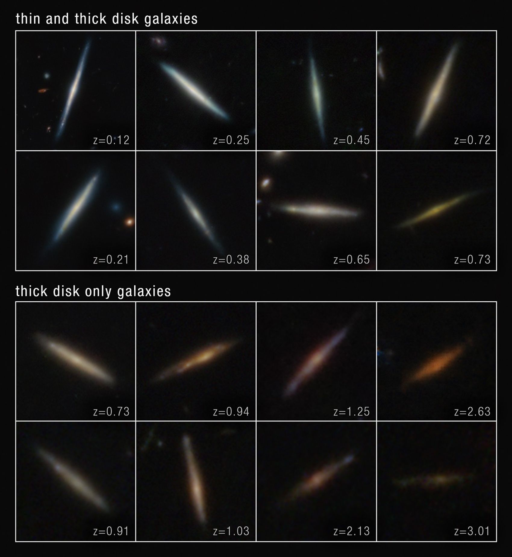
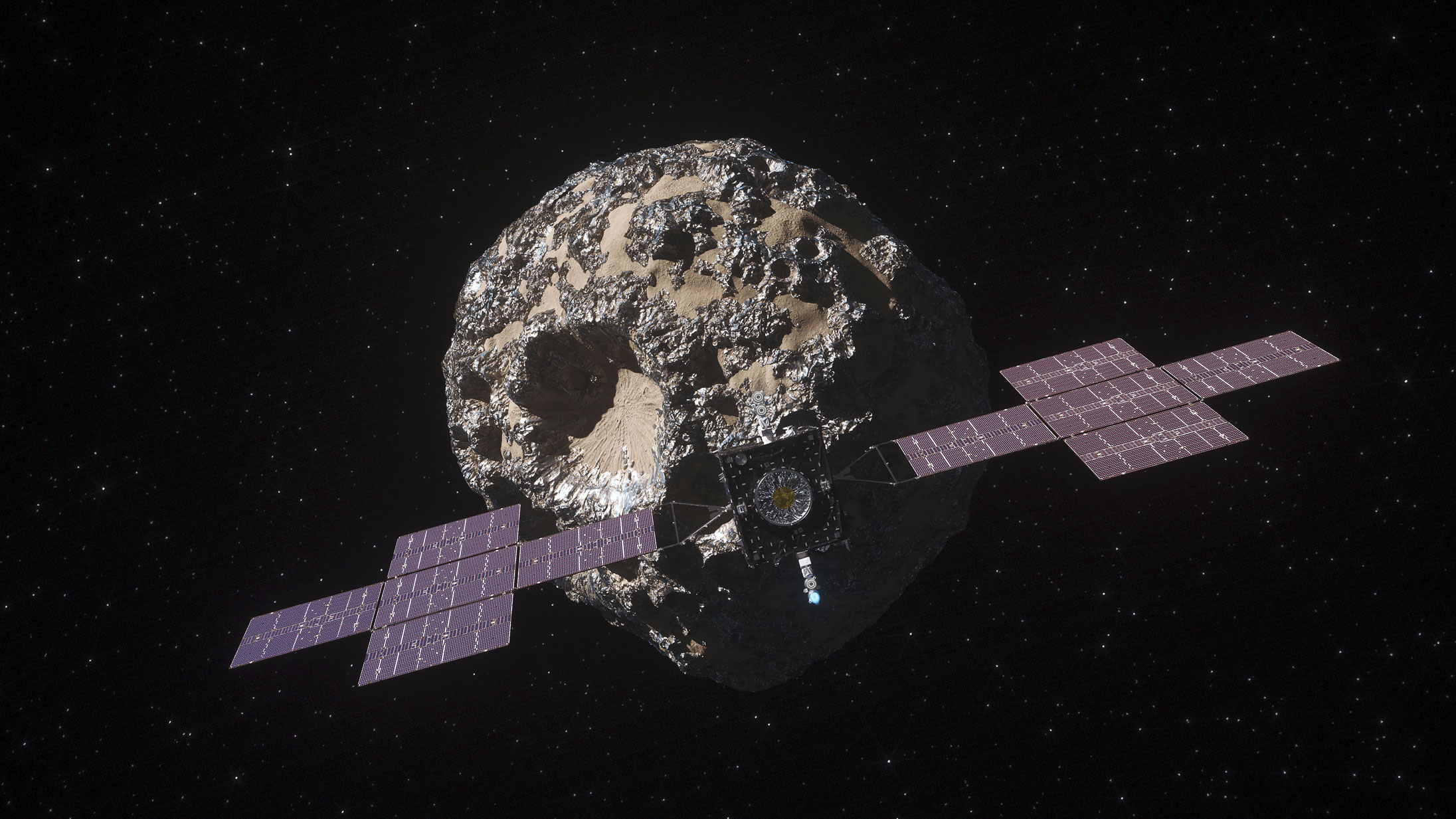
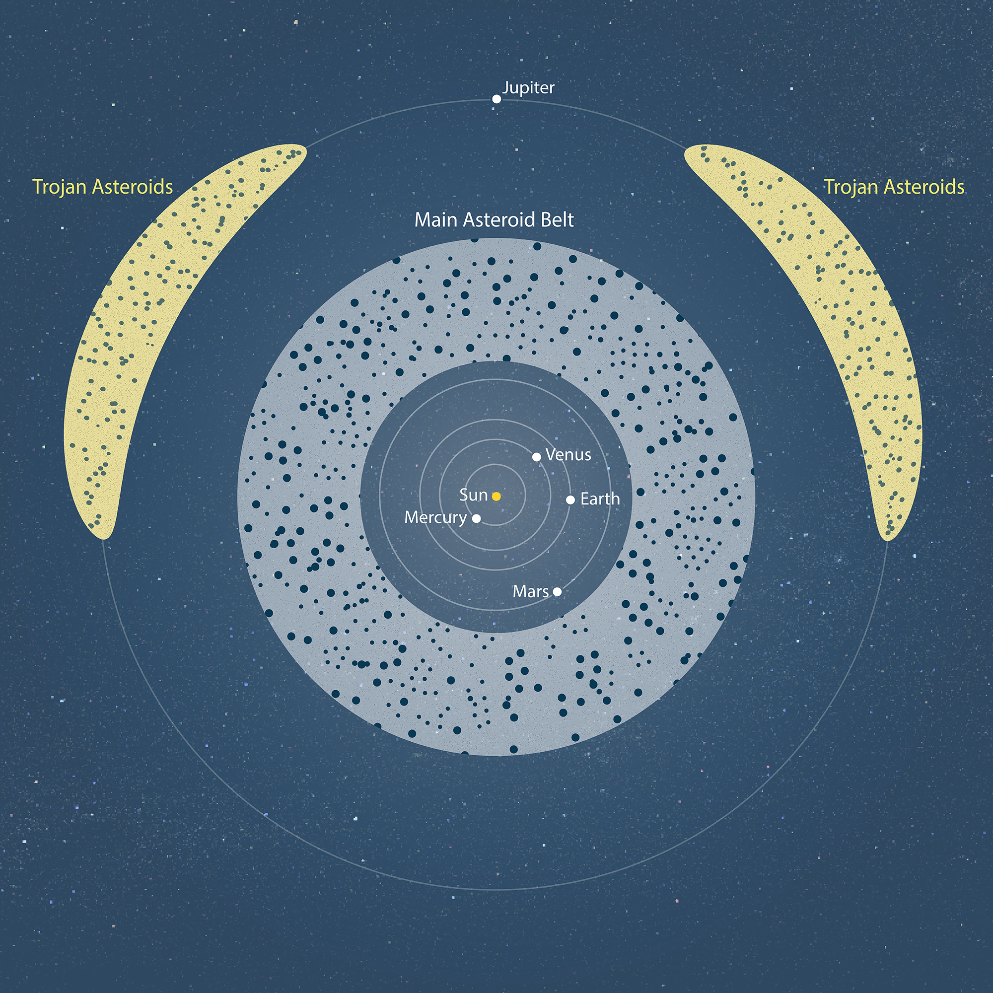