
NASA
NASA Invites Media to View Artemis II Orion Stage Adapter at Marshall
2 min read
Preparations for Next Moonwalk Simulations Underway (and Underwater) The Artemis II Orion stage adapter, built at NASA’s Marshall Space Flight Center in Huntsville, Alabama. NASAMedia are invited to NASA’s Marshall Space Flight Center in Huntsville, Alabama, at 2 p.m. CDT Thursday, Aug. 14 to view the final piece of space flight hardware for the agency’s SLS (Space Launch System) rocket for the Artemis II mission before it is delivered to NASA’s Kennedy Space Center in Florida. All other elements of the SLS rocket for Artemis II are stacked on mobile launcher 1 in the Vehicle Assembly Building at Kennedy. Artemis II, NASA’s first mission with crew aboard the SLS rocket and Orion spacecraft, is currently scheduled for a 10-day trip around the Moon no later than April 2026.
The Orion stage adapter, built by NASA Marshall, connects the SLS rocket’s interim cryogenic propulsion stage to NASA’s Orion spacecraft. The small ring structure is the topmost portion of the SLS rocket. The adapter will also carry small payloads, called CubeSats, to deep space.
Media will have the opportunity to capture images and video and speak to subject matter experts. Along with viewing the adapter for Artemis II, media will be able to see the Orion stage adapter for the Artemis III mission, the first lunar landing at the Moon’s South Pole.
This event is open to U.S. media, who must confirm their attendance by 12 p.m. CDT Wednesday, Aug. 13, with Jonathan Deal in Marshall’s Office of Communications at jonathan.e.deal@nasa.gov. Media must also report by 1:30 p.m. Thursday, Aug.14 to the Redstone Arsenal Joint Visitor Control Center Gate 9 parking lot, located at the Interstate 565 interchange at Research Park Boulevard, to be escorted to the event.
Through Artemis, NASA will send astronauts to explore the Moon for scientific discovery, economic benefits, and build the foundation for the first crewed missions to Mars.
For more on SLS, visit:
https://www.nasa.gov/humans-in-space/space-launch-system
Jonathan Deal
Marshall Space Flight Center, Huntsville, Ala.
256.631.9126
jonathan.e.deal@nasa.gov
NASA’s Hubble Space Telescope and NASA’s Chandra X-ray Observatory have teamed up to identify a…
Article 3 weeks ago 4 min read Stay Cool: NASA Tests Innovative Technique for Super Cold Fuel Storage Article 4 weeks ago 4 min read NASA’s IXPE Imager Reveals Mysteries of Rare Pulsar Article 4 weeks ago Keep Exploring Discover Related TopicsMissions
Humans in Space
Climate Change
Solar System
NASA Invites Media to View Artemis II Orion Stage Adapter at Marshall
2 min read
Preparations for Next Moonwalk Simulations Underway (and Underwater) The Artemis II Orion stage adapter, built at NASA’s Marshall Space Flight Center in Huntsville, Alabama. NASAMedia are invited to NASA’s Marshall Space Flight Center in Huntsville, Alabama, at 2 p.m. CDT Thursday, Aug. 14 to view the final piece of space flight hardware for the agency’s SLS (Space Launch System) rocket for the Artemis II mission before it is delivered to NASA’s Kennedy Space Center in Florida. All other elements of the SLS rocket for Artemis II are stacked on mobile launcher 1 in the Vehicle Assembly Building at Kennedy. Artemis II, NASA’s first mission with crew aboard the SLS rocket and Orion spacecraft, is currently scheduled for a 10-day trip around the Moon no later than April 2026.
The Orion stage adapter, built by NASA Marshall, connects the SLS rocket’s interim cryogenic propulsion stage to NASA’s Orion spacecraft. The small ring structure is the topmost portion of the SLS rocket. The adapter will also carry small payloads, called CubeSats, to deep space.
Media will have the opportunity to capture images and video and speak to subject matter experts. Along with viewing the adapter for Artemis II, media will be able to see the Orion stage adapter for the Artemis III mission, the first lunar landing at the Moon’s South Pole.
This event is open to U.S. media, who must confirm their attendance by 12 p.m. CDT Wednesday, Aug. 13, with Jonathan Deal in Marshall’s Office of Communications at jonathan.e.deal@nasa.gov. Media must also report by 1:30 p.m. Thursday, Aug.14 to the Redstone Arsenal Joint Visitor Control Center Gate 9 parking lot, located at the Interstate 565 interchange at Research Park Boulevard, to be escorted to the event.
Through Artemis, NASA will send astronauts to explore the Moon for scientific discovery, economic benefits, and build the foundation for the first crewed missions to Mars.
For more on SLS, visit:
https://www.nasa.gov/humans-in-space/space-launch-system
Jonathan Deal
Marshall Space Flight Center, Huntsville, Ala.
256.631.9126
jonathan.e.deal@nasa.gov
NASA’s Hubble Space Telescope and NASA’s Chandra X-ray Observatory have teamed up to identify a…
Article 3 weeks ago 4 min read Stay Cool: NASA Tests Innovative Technique for Super Cold Fuel Storage Article 4 weeks ago Keep Exploring Discover Related TopicsMissions
Humans in Space
Climate Change
Solar System
NASA Awards Second Human Health, Performance Contract
NASA has selected KBR Wyle Services, LLC of Fulton, Maryland, to provide services to the Human Health and Performance Directorate at the agency’s Johnson Space Center in Houston, which focuses on astronaut health, occupational health, and research that could help mitigate health risks for future human spaceflight missions.
The Human Health and Performance Contract 2 is a follow-on single-award indefinite-delivery/indefinite-quantity contract that begins its five-year period of performance on Nov. 1, with two possible option periods that could extend it through 2035. The total estimated value of the base period plus the optional periods is $3.6 billion. Leidos, Inc. of Reston, Virginia, is a subcontractor.
The contract will acquire support services for several programs, primarily at NASA Johnson. This includes the Human Research Program, International Space Station Program, Commercial Crew Program, Artemis campaign, and more. Services include ensuring crew health, safety, and performance; providing occupational health services; and conducting research into mitigating risks to the health, safety, and performance of future spaceflight crews.
The Human Health and Performance Directorate leads the global spaceflight community in protecting astronaut health and enabling human mission performance. Its vision focuses on humans living, working, and thriving in space, on the Moon and on to Mars, and its mission is to lead the global spaceflight community in protecting astronaut health and enabling human mission performance.
For more information about NASA and agency programs, visit:
–end–
Tiernan Doyle
Headquarters, Washington
202-358-1600
tiernan.doyle@nasa.gov
Victoria Segovia
Johnson Space Center, Houston
281-483-5111
victoria.segovia@nasa.gov
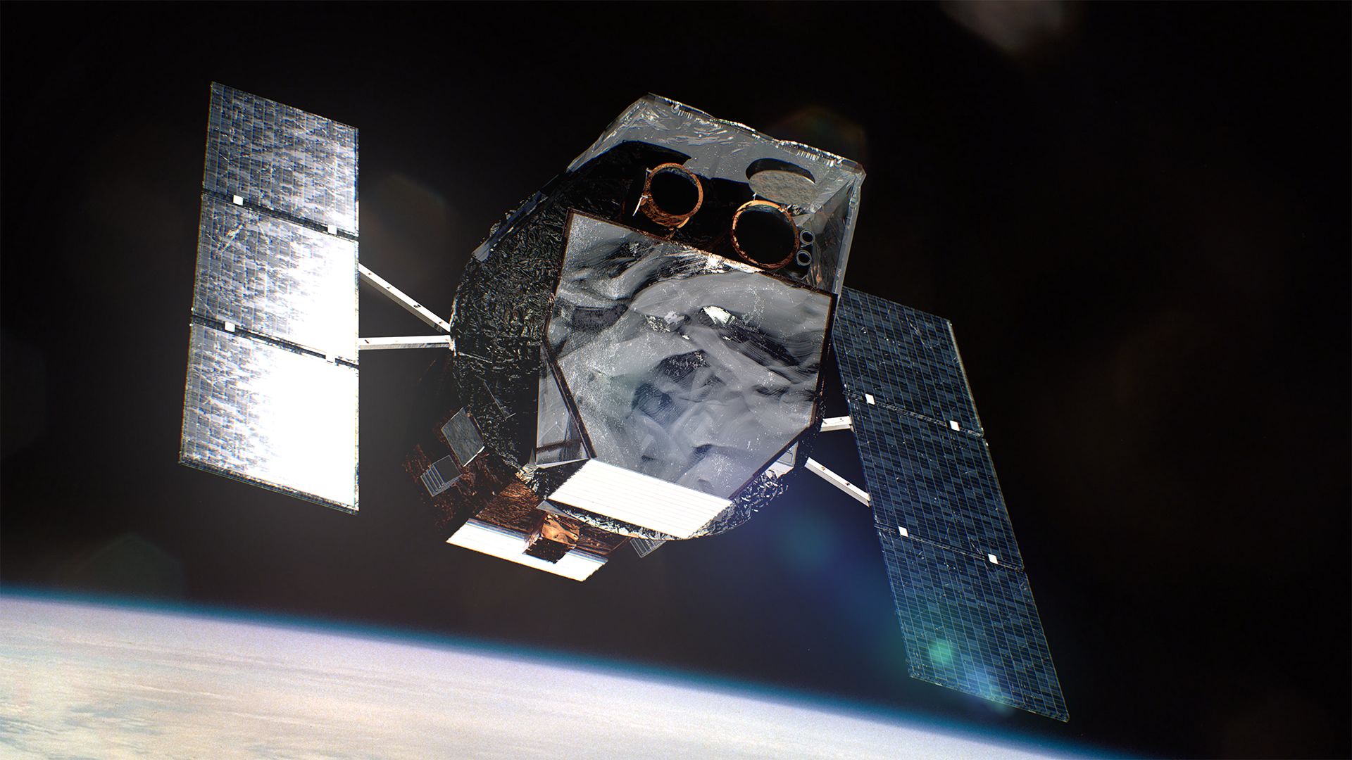
NASA Explores Industry Possibilities to Raise Swift Mission’s Orbit
To drive the development of key space-based capabilities for the United States, NASA is exploring an opportunity to demonstrate technology to raise a spacecraft’s orbit to a higher altitude. Two American companies – Cambrian Works of Reston, Virginia, and Katalyst Space Technologies of Flagstaff, Arizona – will develop concept design studies for a possible orbit boost for the agency’s Neil Gehrels Swift Observatory.
Since its launch in 2004, NASA’s Swift mission has led the agency’s fleet of space telescopes in investigating changes in the high-energy universe. The spacecraft’s low Earth orbit has been decaying gradually, which happens to most satellites over time. Because of recent increases in the Sun’s activity, however, Swift is experiencing additional atmospheric drag, speeding up its orbital decay. This lowering orbit presents an opportunity for NASA to advance a U.S. industry capability, while potentially extending the science lifetime of the Swift mission. The concept studies will help determine whether extending Swift’s critical scientific capabilities would be more cost-effective than replacing those capabilities with a new observatory.
“NASA Science is committed to leveraging commercial technologies to find innovative, cost-effective ways to open new capabilities for the future of the American space sector,” said Nicky Fox, associate administrator, Science Mission Directorate, NASA Headquarters in Washington. “To maintain Swift’s role in our portfolio, NASA Science is uniquely positioned to conduct a rare in-space technology demonstration to raise the satellite’s orbit and solidify American leadership in spacecraft servicing.”
The concept studies are being developed under Phase III awards through NASA’s Small Business Innovation Research (SBIR) Program, managed by the agency’s Space Technology Mission Directorate, to American small businesses from a pool of existing participants. This approach allows NASA to rapidly explore affordable possibilities to boost Swift on a shorter development timeline than would otherwise be possible, given the rapid rate at which Swift’s orbit is decaying.
At this time NASA does not have plans for an orbit boost mission and could still allow the spacecraft to reenter Earth’s atmosphere, as many satellites do at the end of their lifetimes. NASA is studying a potential Swift boost to support innovation in the American space industry, while gaining a better understanding of the available options, the technical feasibility, and the risks involved.
NASA will also work with Starfish Space of Seattle, Washington, to analyze the potential of performing a Swift boost using an asset under development on an existing Phase III SBIR award. Starfish is currently developing the Small Spacecraft Propulsion and Inspection Capability (SSPICY) demonstration for NASA, with the primary objective of inspecting multiple U.S.-owned defunct satellites in low Earth orbit.
“Our SBIR portfolio exists for circumstances like this – where investments in America’s space industry provide NASA and our partners an opportunity to develop mutually beneficial capabilities,” said Clayton Turner, associate administrator, Space Technology Mission Directorate, NASA Headquarters. “Whether we choose to implement the technologies in this circumstance, understanding how to boost a spacecraft’s orbit could prove valuable for future applications.”
Swift was designed to observe gamma-ray bursts, the universe’s most powerful explosions, and provide information for other NASA and partner telescopes to follow up on these events. Its fast and flexible observations have been instrumental in advancing how scientists study transient events to understand how the universe works. For more than two decades, Swift has led NASA’s missions in providing new insights on these events, together broadening our understanding of everything from exploding stars, stellar flares, and eruptions in active galaxies, to comets and asteroids in our own solar system and high-energy lightning events on Earth.
As neutron stars collide, some of the debris blasts away in particle jets moving at nearly the speed of light, producing a brief burst of gamma rays.NASA’s Goddard Space Flight Center/CI Lab“Over its extremely productive lifetime, Swift has been a key player in NASA’s network of space telescopes – directing our fleet to ensure we keep a watchful eye on changes in the universe, both far off and close to home,” said Shawn Domagal-Goldman, acting director, Astrophysics Division, NASA Headquarters. “Now, this long-lived science mission is presenting us with a new opportunity: partnering with U.S. industry to rapidly explore efficient, state-of-the-art solutions that could extend Swift’s transformative work and advance private spacecraft servicing.”
Cambrian and Katalyst have each been awarded $150,000 under Phase III SBIR contracts for concept design studies. The NASA SBIR program is part of America’s Seed Fund, the nation’s largest source of early-stage, non-dilutive funding for innovative technologies. Through this program, entrepreneurs, startups, and small businesses with less than 500 employees can receive funding and non-monetary support to build, mature, and commercialize their technologies, advancing NASA missions and helping solve important problems facing our country.
NASA’s Goddard Space Flight Center in Greenbelt, Maryland, manages the Swift mission in collaboration with Penn State, the Los Alamos National Laboratory in New Mexico, and Northrop Grumman Space Systems in Dulles, Virginia. Other partners include the UK Space Agency, University of Leicester and Mullard Space Science Laboratory in the United Kingdom, Brera Observatory in Italy, and the Italian Space Agency. To learn more about the Swift mission, visit:
-end-
Alise Fisher / Jasmine Hopkins
Headquarters, Washington
202-358-2546 / 321-432-4624
alise.m.fisher@nasa.gov / jasmine.s.hopkins@nasa.gov
Space Station Cell Studies
Cells are the basic building blocks of all living things, from single-celled bacteria to plants and animals containing vast numbers of them. Cells have adapted for a wide variety of settings and functions. Nerve cells in humans and animals, for example, have long, thin extensions that rapidly transmit signals, while rigid, blocky cells support the structure of plants.
Cell biology is the study of cell structure, function, and behavior. For humans, scientists in this field explore the mechanisms of diseases from bone loss to cancer and work on developing treatments.
Cell-based experiments on The International Space Station help identify how spaceflight affects people and other living systems, with applications for future space exploration and life on Earth.
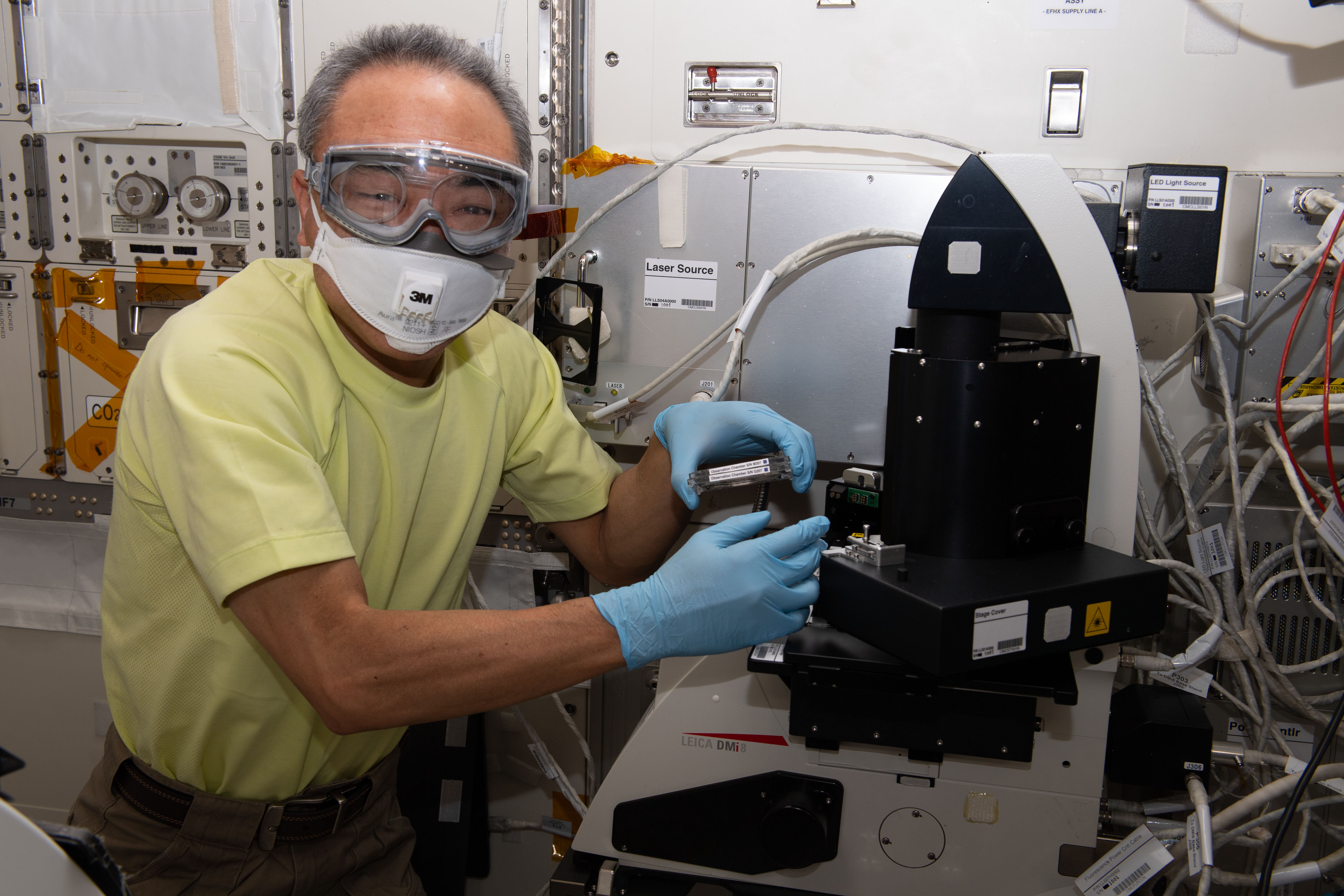
JAXA astronaut Satoshi Furukawa prepares to examine cells for Cell Gravisensing in the JAXA Confocal Microscope (COSMIC).NASARecent experiments have revealed that individual animal cells react to the effects of gravity, but how they do so is largely unknown. Cell Gravisensing, an investigation from JAXA (Japan Aerospace Exploration Agency), examines the molecular mechanism behind the ability of cells to sense gravity. Results could support development of drugs to treat muscle atrophy and osteoporosis in space and on Earth.
Cardiovascular cells Microscopic view of cells from the lining of blood vessels cultured for the STaARS BioScience-3 experiment. University of FloridaIn microgravity, some astronauts experience changes in their cardiovascular system, including reduced blood volume and diminished cardiac output. An earlier investigation, STaARS Bioscience-3, examined the mechanisms behind these changes at the cellular and genetic level. The research revealed that, after only three days of spaceflight, there were changes in the expression of more than 11,000 genes in blood vessel cells that could alter their functions. The results laid the groundwork for additional research into cell response to spaceflight that could help protect the health of crew members on future missions and people with cardiovascular diseases on Earth.
Neural cellsSTaARS BioScience-4 examined microgravity’s effects on neural stem cells that give rise to central nervous system cells. Researchers found changes in production and consumption of energy and increased breakdown of cellular components in these cells, responses that likely enhance adaptation to microgravity. The finding also highlights the importance of providing astronauts with sufficient energy for cognitive and physiological function on future missions.
Fish cells A preflight image of samples and sample chambers for the Fish Scales investigation. Mitchell/PrangeGoldfish scales have many of the same proteins, minerals, and cell types as the bones of mammals. The JAXA Fish Scales investigation analyzed goldfish scales exposed to three times Earth’s gravity, simulated microgravity, and microgravity on orbit. Researchers determined that goldfish scales can be used as a model to help them understand how human bones respond to spaceflight.
Mouse cellsResearch with model organisms like rodents has relevance to humans in space and makes significant contributions to understanding human aging, disease, and the effects of microgravity on biological and physical processes. JAXA’s Stem Cells studied how spaceflight affected the DNA and chromosomes of embryonic mouse stem cells, and their ability to develop into adult mice after return to Earth.
Researchers analyzed unaltered cells and cells given a mutation to increase responsiveness to radiation. They found no chromosomal differences between the unaltered space-flown cells and ground controls, but the mutated cells had more DNA abnormalities. The work could enhance the understanding of radiation effects on human cancer and improve risk assessment for long-duration missions to the Moon and Mars.
NASA astronauts Drew Morgan and Christina Koch work on rodent research hardware. NASAAnother study used tissue samples from RR-1, which are available through NASA’s GeneLab open data repository. Analysis showed that the heart can adapt to the stress of spaceflight in just 30 days. The researchers observed genetic changes suggesting that this adaptation may facilitate survival in space and could have applications in treating heart disease in space and on Earth.
Keep Exploring Discover More Topics From NASAHumans In Space
Latest News from Space Station Research
Space Station Research and Technology Tools and Information
Space Station Research Results
Space Station Cell Studies
Cells are the basic building blocks of all living things, from single-celled bacteria to plants and animals containing vast numbers of them. Cells have adapted for a wide variety of settings and functions. Nerve cells in humans and animals, for example, have long, thin extensions that rapidly transmit signals, while rigid, blocky cells support the structure of plants.
Cell biology is the study of cell structure, function, and behavior. For humans, scientists in this field explore the mechanisms of diseases from bone loss to cancer and work on developing treatments.
Cell-based experiments on The International Space Station help identify how spaceflight affects people and other living systems, with applications for future space exploration and life on Earth.
JAXA astronaut Satoshi Furukawa prepares to examine cells for Cell Gravisensing in the JAXA Confocal Microscope (COSMIC).NASARecent experiments have revealed that individual animal cells react to the effects of gravity, but how they do so is largely unknown. Cell Gravisensing, an investigation from JAXA (Japan Aerospace Exploration Agency), examines the molecular mechanism behind the ability of cells to sense gravity. Results could support development of drugs to treat muscle atrophy and osteoporosis in space and on Earth.
Cardiovascular cells Microscopic view of cells from the lining of blood vessels cultured for the STaARS BioScience-3 experiment. University of FloridaIn microgravity, some astronauts experience changes in their cardiovascular system, including reduced blood volume and diminished cardiac output. An earlier investigation, STaARS Bioscience-3, examined the mechanisms behind these changes at the cellular and genetic level. The research revealed that, after only three days of spaceflight, there were changes in the expression of more than 11,000 genes in blood vessel cells that could alter their functions. The results laid the groundwork for additional research into cell response to spaceflight that could help protect the health of crew members on future missions and people with cardiovascular diseases on Earth.
Neural cellsSTaARS BioScience-4 examined microgravity’s effects on neural stem cells that give rise to central nervous system cells. Researchers found changes in production and consumption of energy and increased breakdown of cellular components in these cells, responses that likely enhance adaptation to microgravity. The finding also highlights the importance of providing astronauts with sufficient energy for cognitive and physiological function on future missions.
Fish cells A preflight image of samples and sample chambers for the Fish Scales investigation. Mitchell/PrangeGoldfish scales have many of the same proteins, minerals, and cell types as the bones of mammals. The JAXA Fish Scales investigation analyzed goldfish scales exposed to three times Earth’s gravity, simulated microgravity, and microgravity on orbit. Researchers determined that goldfish scales can be used as a model to help them understand how human bones respond to spaceflight.
Mouse cellsResearch with model organisms like rodents has relevance to humans in space and makes significant contributions to understanding human aging, disease, and the effects of microgravity on biological and physical processes. JAXA’s Stem Cells studied how spaceflight affected the DNA and chromosomes of embryonic mouse stem cells, and their ability to develop into adult mice after return to Earth.
Researchers analyzed unaltered cells and cells given a mutation to increase responsiveness to radiation. They found no chromosomal differences between the unaltered space-flown cells and ground controls, but the mutated cells had more DNA abnormalities. The work could enhance the understanding of radiation effects on human cancer and improve risk assessment for long-duration missions to the Moon and Mars.
NASA astronauts Drew Morgan and Christina Koch work on rodent research hardware. NASAAnother study used tissue samples from RR-1, which are available through NASA’s GeneLab open data repository. Analysis showed that the heart can adapt to the stress of spaceflight in just 30 days. The researchers observed genetic changes suggesting that this adaptation may facilitate survival in space and could have applications in treating heart disease in space and on Earth.
Keep Exploring Discover More Topics From NASAHumans In Space
Latest News from Space Station Research
Space Station Research and Technology Tools and Information
Space Station Research Results
NASA Continues Search for Moon-Focused Sustainability Solutions
NASA is accepting U.S. submissions for the second phase of the agency’s LunaRecycle Challenge, a Moon-focused recycling competition. The challenge aims to develop solutions for recycling common trash materials – like fabrics, plastics, foam, and metals – that could accumulate from activities such as system operations, industrial activities, and building habitats in deep space.
Phase 2 of the LunaRecycle Challenge is divided into two levels: a milestone round and the final round. Submissions for the milestone round are open until January 2026, with finalists from that round announced in February. Up to 20 finalists from the milestone round will compete in the challenge’s in-person prototype demonstrations and final judging, slated for the following August. Cash prizes totaling $2 million are available for successful solutions in both rounds.
“NASA is eager to see how reimagining these materials can be helpful to potential future planetary surface missions,” said Jennifer Edmunson, acting program manager for Centennial Challenges at NASA’s Marshall Space Flight Center in Huntsville, Alabama. “I’m confident focusing on the most critical trash items – and integration of the prototype and digital twin competition tracks – will yield remarkable solutions that could enable a sustainable human presence off-Earth and transform the future of space exploration.”
Estimates indicate a crew of four astronauts could generate more than 2,100 kilograms (4,600 pounds) of single-use waste – including food packaging, plastic films, foam packaging, clothing, and more – within 365 days. Successful solutions in LunaRecycle’s Phase 2 should manage realistic trash volumes while minimizing resource inputs and crew time and operating safely with minimal hazards.
Phase 2 is only open to U.S. individuals and teams. Participants can submit solutions regardless of whether they competed in the earlier Phase 1 competition.
All Phase 2 participants are expected to build a physical prototype. In addition, participants can submit a digital twin of their prototype for additional awards in the milestone and final rounds.
The LunaRecycle Challenge is a NASA Centennial Challenge, part of the Prizes, Challenges and Crowdsourcing Program within NASA’s Space Technology Mission Directorate. LunaRecycle Phase 1 received record-breaking interest from the global innovator community. The challenge received more than 1,200 registrations – more than any competition in the 20-year history of Centennial Challenges – and a panel of 50 judges evaluated nearly 200 submissions. Seventeen teams were selected as Phase 1 winners, representing five countries and nine U.S. states. Winners were announced via livestream on NASA Marshall’s YouTube channel.
LunaRecycle is managed at NASA Marshall with subject matter experts primarily at the center, as well as NASA’s Kennedy Space Center in Florida and NASA’s Ames Research Center in California’s Silicon Valley. NASA, in partnership with The University of Alabama College of Engineering, manages the challenge with coordination from former Centennial Challenge winner AI SpaceFactory and environmental sustainability industry member Veolia.
To learn more about LunaRecycle’s second phase, including registration for upcoming webinars, visit:
https://www.nasa.gov/lunarecycle
-end-
Jasmine Hopkins
NASA Headquarters, Washington
321-432-4624
jasmine.s.hopkins@nasa.gov
Taylor Goodwin
Marshall Space Flight Center, Huntsville, Ala.
256-544-0034
taylor.goodwin@nasa.gov
NASA’s SpaceX Crew-10 Splashes Down in Pacific Ocean
NASA’s SpaceX Crew-10 Splashes Down in Pacific Ocean
The members of NASA’s SpaceX Crew-10 mission – Roscosmos cosmonaut Kirill Peskov, left, NASA astronauts Nichole Ayers and Anne McClain, and JAXA (Japan Aerospace Exploration Agency) astronaut Takuya Onishi – are all smiles after having landed in the Pacific Ocean off the coast of San Diego, Calif., Saturday, Aug. 9, 2025. The crew spent seven months aboard the International Space Station.
Along the way, Crew-10 contributed hundreds of hours to scientific research, maintenance activities, and technology demonstrations. McClain, Ayers, and Onishi completed investigations on plant and microalgae growth, examined how space radiation affects DNA sequences in plants, observed how microgravity changes human eye structure and cells in the body, and more. The research conducted aboard the orbiting laboratory advances scientific knowledge and demonstrates new technologies that enable us to prepare for human exploration of the Moon and Mars.
McClain and Ayers also completed a spacewalk on May 1. It was the third spacewalk for McClain and the first for Ayers.
See more photos from Crew-10 Splashdown.
Image credit: NASA/Keegan Barber
Juliana Barajas: Supporting NASA’s Mission, One Task at a Time
As an administrative assistant in the Safety and Mission Assurance Office at NASA’s White Sands Test Facility in Las Cruces, New Mexico, Juliana Barajas approaches her work with one clear mission: to help others succeed.
Juliana Barajas stands in front of the Super Guppy at the El Paso Forwarding Operations Location (EPFOL) in El Paso, Texas. Being courteous, helpful, resourceful, and always willing to learn new things is what led me to NASA.Juliana Barajas
Administrative Assistant
For over two decades, she has supported NASA’s mission with a career grounded in service, perseverance, and gratitude. Whether coordinating tasks, solving problems, or lending a listening ear, Barajas plays a vital role in helping her team maintain safety and excellence.
“When I was young, I never imagined working at NASA,” said Barajas “I dreamed of studying mechanical engineering but never got the opportunity.”
Instead, she pursued a degree in computer secretarial studies. “I am grateful for the opportunity to prove I could do just about any job given to me,” she said.
Juliana Barajas received a Secretarial Excellence Award in 2009 at NASA’s Johnson Space Center in Houston.In 2009, Barajas earned the Secretarial Excellence Award, a recognition she calls a highlight of her career. But for Barajas, pride is not reserved for big moments alone. “I take pride in everything I do every day,” she said. “If I can help those around me succeed, then I have fulfilled my duty.”
Her career has also taught her invaluable personal lessons. “I’ve learned to be a good listener and to be myself,” she said. “I’ve also learned to be resourceful and to not give up. I am grateful for having wonderful people around me who don’t look down on me when I reach out for answers.”
Juliana Barajas (far right) and her colleagues at NASA’s White Sands Test Facility in Las Cruces, New Mexico.As NASA continues preparing for future lunar missions, Barajas hopes to pass on courage, resilience, and the determination to persevere through challenges. She encourages the next generation to ask for help when needed and to speak up when it matters most.
“I love my job and would like to continue supporting my NASA family as long as I am able,” she said. “And I promise to keep being the person I am.”
Explore More 3 min read Aaisha Ali: From Marine Biology to the Artemis Control Room Article 1 month ago 3 min read Michael Ciancone Builds a Lasting Legacy in Human Spaceflight Article 4 months ago 5 min read Johnson’s Jason Foster Recognized for New Technology Reporting Record Article 2 months agoJuliana Barajas: Supporting NASA’s Mission, One Task at a Time
As an administrative assistant in the Safety and Mission Assurance Office at NASA’s White Sands Test Facility in Las Cruces, New Mexico, Juliana Barajas approaches her work with one clear mission: to help others succeed.
Juliana Barajas stands in front of the Super Guppy at the El Paso Forwarding Operations Location (EPFOL) in El Paso, Texas. Being courteous, helpful, resourceful, and always willing to learn new things is what led me to NASA.Juliana Barajas
Administrative Assistant
For over two decades, she has supported NASA’s mission with a career grounded in service, perseverance, and gratitude. Whether coordinating tasks, solving problems, or lending a listening ear, Barajas plays a vital role in helping her team maintain safety and excellence.
“When I was young, I never imagined working at NASA,” said Barajas “I dreamed of studying mechanical engineering but never got the opportunity.”
Instead, she pursued a degree in computer secretarial studies. “I am grateful for the opportunity to prove I could do just about any job given to me,” she said.
Juliana Barajas received a Secretarial Excellence Award in 2009 at NASA’s Johnson Space Center in Houston.In 2009, Barajas earned the Secretarial Excellence Award, a recognition she calls a highlight of her career. But for Barajas, pride is not reserved for big moments alone. “I take pride in everything I do every day,” she said. “If I can help those around me succeed, then I have fulfilled my duty.”
Her career has also taught her invaluable personal lessons. “I’ve learned to be a good listener and to be myself,” she said. “I’ve also learned to be resourceful and to not give up. I am grateful for having wonderful people around me who don’t look down on me when I reach out for answers.”
Juliana Barajas (far right) and her colleagues at NASA’s White Sands Test Facility in Las Cruces, New Mexico.As NASA continues preparing for future lunar missions, Barajas hopes to pass on courage, resilience, and the determination to persevere through challenges. She encourages the next generation to ask for help when needed and to speak up when it matters most.
“I love my job and would like to continue supporting my NASA family as long as I am able,” she said. “And I promise to keep being the person I am.”
Explore More 3 min read Aaisha Ali: From Marine Biology to the Artemis Control Room Article 1 month ago 3 min read Michael Ciancone Builds a Lasting Legacy in Human Spaceflight Article 4 months ago 5 min read Johnson’s Jason Foster Recognized for New Technology Reporting Record Article 2 months agoNASA’s SpaceX Crew-10 Mission Returns, Splashes Down Off California
Editor’s Note: This release was edited Aug. 9, 2025, to update the International Space Station docking port for the Crew-10 mission.
The first crew to splash down in the Pacific Ocean off the coast of California as part of NASA’s Commercial Crew Program completed the agency’s 10th commercial crew rotation mission to the International Space Station on Saturday.
NASA astronauts Anne McClain and Nichole Ayers, JAXA (Japan Aerospace Exploration Agency) astronaut Takuya Onishi, and Roscosmos cosmonaut Kirill Peskov returned to Earth at 11:33 a.m. EDT. Teams aboard SpaceX recovery vessels retrieved the spacecraft and its crew. After returning to shore, the crew will fly to NASA’s Johnson Space Center in Houston and reunite with their families.
“Splashdown! Crew-10 is back on Earth from the International Space Station marking the completion of another successful flight,” said NASA acting Administrator Sean Duffy. “Our crew missions are the building blocks for long-duration, human exploration pushing the boundaries of what’s possible. NASA is leading the way by setting a bold vision for exploration where we have a thriving space industry supporting private space stations in low Earth orbit, as well as humans exploring the Moon and Mars.”
The agency’s SpaceX Crew-10 mission lifted off at 7:03 p.m. on March 14, from Launch Complex 39A at NASA’s Kennedy Space Center in Florida. About 29 hours later, the crew’s SpaceX Dragon spacecraft docked to the Harmony module’s forward-facing port at 12:04 a.m. on March 16. Crew-10 undocked at 6:15 p.m. Aug. 8, to begin the trip home.
During their mission, crew members traveled nearly 62,795,205 million miles and completed 2,368 orbits around Earth. The Crew-10 mission was the first spaceflight for Ayers and Peskov, and the second spaceflight for McClain and Onishi. McClain has logged 352 days in space over her two flights, and Onishi has logged 263 days in space during his flights.
Along the way, Crew-10 contributed hundreds of hours to scientific research, maintenance activities, and technology demonstrations. McClain, Ayers, and Onishi completed investigations on plant and microalgae growth, examined how space radiation affects DNA sequences in plants, observed how microgravity changes human eye structure and cells in the body, and more. The research conducted aboard the orbiting laboratory advances scientific knowledge and demonstrates new technologies that enable us to prepare for human exploration of the Moon and Mars.
McClain and Ayers also completed a spacewalk on May 1, relocating a communications antenna, beginning the installation of a mounting bracket for a future International Space Station Roll-Out Solar Array, and other tasks. It was the third spacewalk for McClain, the first for Ayers, and the 275th supporting space station assembly, maintenance, and upgrades.
Crew-10’s return to Earth follows the Crew-11 mission, which docked to the station on Aug. 2 for its long-duration science expedition.
NASA’s Commercial Crew Program provides reliable access to space, maximizing the use of the International Space Station for research and development, and supporting future missions beyond low Earth orbit, such as to the Moon and Mars, by partnering with private U.S. companies, including SpaceX, to transport astronauts to and from the space station.
Learn more about NASA’s Commercial Crew Program at:
https://www.nasa.gov/commercialcrew
-end-
Joshua Finch / Jimi Russell
Headquarters, Washington
202-358-1100
joshua.a.finch@nasa.gov / james.j.russell@nasa.gov
Sandra Jones / Joseph Zakrzewski
Johnson Space Center, Houston
281-483-5111
sandra.p.jones@nasa.gov / joseph.a.zakrzewski@nasa.gov
Steven Siceloff
Kennedy Space Center, Florida
321-867-2468
steven.p.siceloff@nasa.gov
NASA’s SpaceX Crew-10 Mission Returns, Splashes Down Off California
Editor’s Note: This release was edited Aug. 9, 2025, to update the International Space Station docking port for the Crew-10 mission.
The first crew to splash down in the Pacific Ocean off the coast of California as part of NASA’s Commercial Crew Program completed the agency’s 10th commercial crew rotation mission to the International Space Station on Saturday.
NASA astronauts Anne McClain and Nichole Ayers, JAXA (Japan Aerospace Exploration Agency) astronaut Takuya Onishi, and Roscosmos cosmonaut Kirill Peskov returned to Earth at 11:33 a.m. EDT. Teams aboard SpaceX recovery vessels retrieved the spacecraft and its crew. After returning to shore, the crew will fly to NASA’s Johnson Space Center in Houston and reunite with their families.
“Splashdown! Crew-10 is back on Earth from the International Space Station marking the completion of another successful flight,” said NASA acting Administrator Sean Duffy. “Our crew missions are the building blocks for long-duration, human exploration pushing the boundaries of what’s possible. NASA is leading the way by setting a bold vision for exploration where we have a thriving space industry supporting private space stations in low Earth orbit, as well as humans exploring the Moon and Mars.”
The agency’s SpaceX Crew-10 mission lifted off at 7:03 p.m. on March 14, from Launch Complex 39A at NASA’s Kennedy Space Center in Florida. About 29 hours later, the crew’s SpaceX Dragon spacecraft docked to the Harmony module’s forward-facing port at 12:04 a.m. on March 16. Crew-10 undocked at 6:15 p.m. Aug. 8, to begin the trip home.
During their mission, crew members traveled nearly 62,795,205 million miles and completed 2,368 orbits around Earth. The Crew-10 mission was the first spaceflight for Ayers and Peskov, and the second spaceflight for McClain and Onishi. McClain has logged 352 days in space over her two flights, and Onishi has logged 263 days in space during his flights.
Along the way, Crew-10 contributed hundreds of hours to scientific research, maintenance activities, and technology demonstrations. McClain, Ayers, and Onishi completed investigations on plant and microalgae growth, examined how space radiation affects DNA sequences in plants, observed how microgravity changes human eye structure and cells in the body, and more. The research conducted aboard the orbiting laboratory advances scientific knowledge and demonstrates new technologies that enable us to prepare for human exploration of the Moon and Mars.
McClain and Ayers also completed a spacewalk on May 1, relocating a communications antenna, beginning the installation of a mounting bracket for a future International Space Station Roll-Out Solar Array, and other tasks. It was the third spacewalk for McClain, the first for Ayers, and the 275th supporting space station assembly, maintenance, and upgrades.
Crew-10’s return to Earth follows the Crew-11 mission, which docked to the station on Aug. 2 for its long-duration science expedition.
NASA’s Commercial Crew Program provides reliable access to space, maximizing the use of the International Space Station for research and development, and supporting future missions beyond low Earth orbit, such as to the Moon and Mars, by partnering with private U.S. companies, including SpaceX, to transport astronauts to and from the space station.
Learn more about NASA’s Commercial Crew Program at:
https://www.nasa.gov/commercialcrew
-end-
Joshua Finch / Jimi Russell
Headquarters, Washington
202-358-1100
joshua.a.finch@nasa.gov / james.j.russell@nasa.gov
Sandra Jones / Joseph Zakrzewski
Johnson Space Center, Houston
281-483-5111
sandra.p.jones@nasa.gov / joseph.a.zakrzewski@nasa.gov
Steven Siceloff
Kennedy Space Center, Florida
321-867-2468
steven.p.siceloff@nasa.gov
