
NASA
NASA Reveals New Details About Dark Matter’s Influence on Universe
With the Webb telescope’s unprecedented sensitivity, scientists are learning more about dark matter’s influence on stars, galaxies, and even planets like Earth.
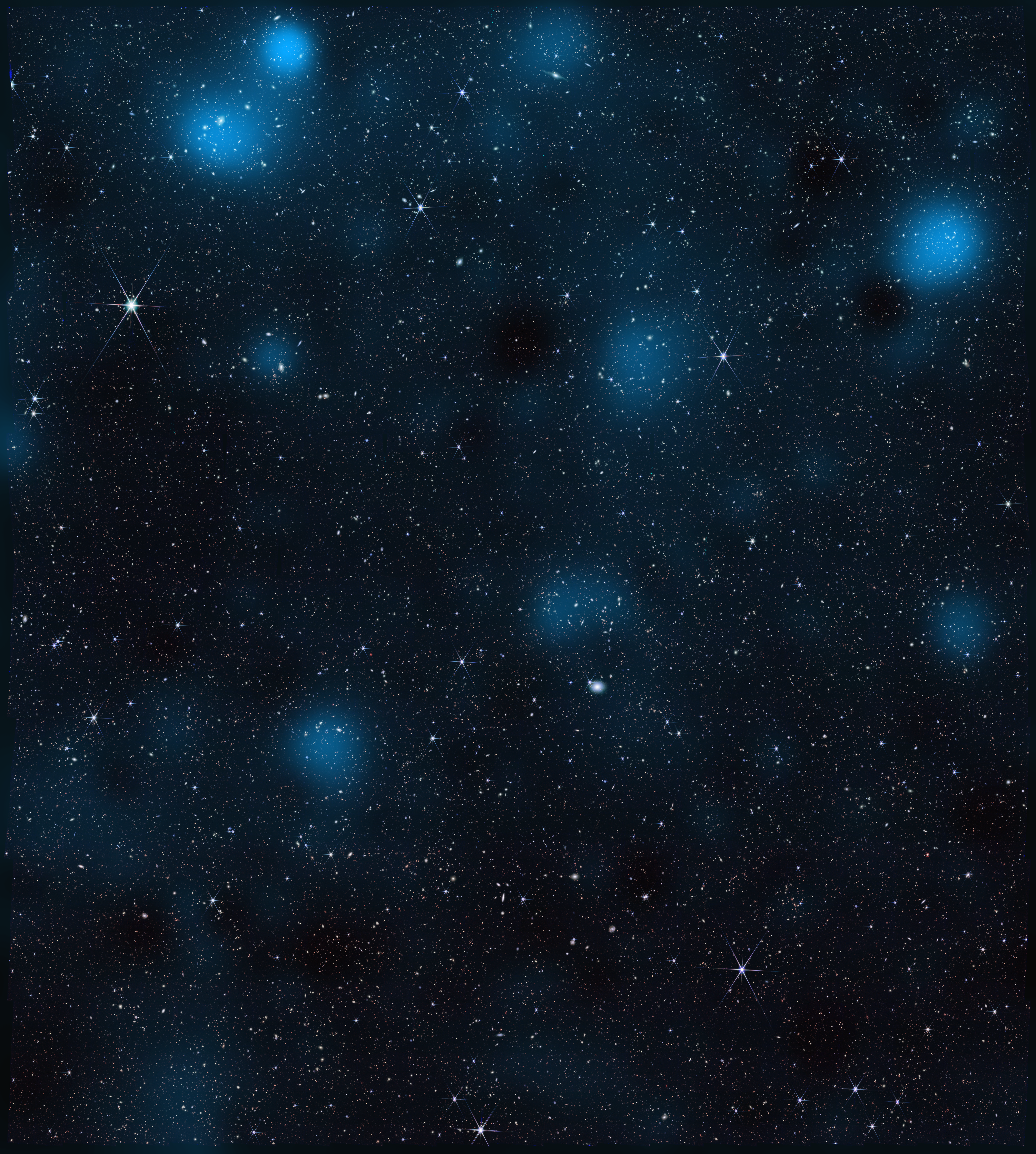
Scientists using data from NASA’s James Webb Space Telescope have made one of the most detailed, high-resolution maps of dark matter ever produced. It shows how the invisible, ghostly material overlaps and intertwines with “regular” matter, the stuff that makes up stars, galaxies, and everything we can see.
Published Monday, Jan. 26, in Nature Astronomy, the map builds on previous research to provide additional confirmation and new details about how dark matter has shaped the universe on the largest scales — galaxy clusters millions of light-years across — that ultimately give rise to galaxies, stars, and planets like Earth.
“This is the largest dark matter map we’ve made with Webb, and it’s twice as sharp as any dark matter map made by other observatories,” said Diana Scognamiglio, lead author of the paper and an astrophysicist at NASA’s Jet Propulsion Laboratory in Southern California. “Previously, we were looking at a blurry picture of dark matter. Now we’re seeing the invisible scaffolding of the universe in stunning detail, thanks to Webb’s incredible resolution.”
Created using data from NASA’s Webb telescope in 2026 (right) and from the Hubble Space Telescope in 2007 (left), these images show the presence of dark matter in the same region of sky. Webb’s higher resolution is providing new insights into how this invisible component influences the distribution of ordinary matter in the universe.NASA/STScI/A. Pagan Dense regions of dark matter are connected by lower-density filaments, forming a weblike structure known as the cosmic web. This pattern appears more clearly in the Webb data than in the earlier Hubble image. Ordinary matter, including galaxies, tends to trace this same underlying structure shaped by dark matter.NASA/STScI/A. Pagan Some dark matter structures appear smaller in the Webb data because they are coming into sharper focus. Webb’s higher resolution also makes it possible to better confine the size and location of the dark matter clusters in the lower left of the image.NASA/STScI/A. PaganDark matter doesn’t emit, reflect, absorb, or even block light, and it passes through regular matter like a ghost. But it does interact with the universe through gravity, something the map shows with a new level of clarity. Evidence for this interaction lies in the degree of overlap between dark matter and regular matter. According to the paper’s authors, Webb’s observations confirm that this close alignment can’t be a coincidence but, rather, is due to dark matter’s gravity pulling regular matter toward it throughout cosmic history.
“Wherever we see a big cluster of thousands of galaxies, we also see an equally massive amount of dark matter in the same place. And when we see a thin string of regular matter connecting two of those clusters, we see a string of dark matter as well,” said Richard Massey, an astrophysicist at Durham University in the United Kingdom and a coauthor of the new study. “It’s not just that they have the same shapes. This map shows us that dark matter and regular matter have always been in the same place. They grew up together.”
Closer lookFound in the constellation Sextans, the area covered by the new map is a section of sky about 2.5 times larger than the full Moon. A global community of scientists have observed this region with at least 15 ground- and space-based telescopes for the Cosmic Evolution Survey (COSMOS). Their goal: to precisely measure the location of regular matter here and then compare it to the location of dark matter. The first dark matter map of the area was made in 2007 using data from NASA’s Hubble Space Telescope, a project led by Massey and JPL astrophysicist Jason Rhodes, a coauthor of the paper.
Webb peered at this region for a total of about 255 hours and identified nearly 800,000 galaxies, some of which were detected for the first time. Scognamiglio and her colleagues then looked for dark matter by observing how its mass curves space itself, which in turn bends the light traveling to Earth from distant galaxies. When observed by researchers, it’s as if the light of those galaxies has passed through a warped windowpane.
The Webb map contains about 10 times more galaxies than maps of the area made by ground-based observatories and twice as many as Hubble’s. It reveals new clumps of dark matter and captures a higher-resolution view of the areas previously seen by Hubble.
To refine measurements of the distance to many galaxies for the map, the team used Webb’s Mid-Infrared Instrument (MIRI), designed and managed through launch by JPL, along with other space- and ground-based telescopes. The wavelengths that MIRI detects also make it adept at detecting galaxies obscured by cosmic dust clouds.
Why it mattersWhen the universe began, regular matter and dark matter were probably sparsely distributed. Scientists think dark matter began to clump together first and that those dark matter clumps then pulled together regular matter, creating regions with enough material for stars and galaxies to begin to form.
In this way, dark matter determined the large-scale distribution of galaxies in the universe. And by prompting galaxy and star formation to begin earlier than they would have otherwise, dark matter’s influence also played a role in creating the conditions for planets to eventually form. That’s because the first generations of stars were responsible for turning hydrogen and helium — which made up the vast majority of atoms in the early universe — into the rich array of elements that now compose planets like Earth. In other words, dark matter provided more time for complex planets to form.
“This map provides stronger evidence that without dark matter, we might not have the elements in our galaxy that allowed life to appear,” said Rhodes. “Dark matter is not something we encounter in our everyday life on Earth, or even in our solar system, but it has definitely influenced us.”
Scognamiglio and some of her coauthors will also map dark matter with NASA’s upcoming Nancy Grace Roman Space Telescope over an area 4,400 times bigger than the COSMOS region. Roman’s primary science goals include learning more about dark matter’s fundamental properties and how they may or may not have changed over cosmic history. But Roman’s maps won’t beat Webb’s spatial resolution. More detailed looks at dark matter will be possible only with a next-generation telescope like the Habitable Worlds Observatory, NASA’s next astrophysics flagship concept.
More about WebbThe James Webb Space Telescope is solving mysteries in our solar system, looking beyond to distant worlds around other stars, and probing the mysterious structures and origins of our universe and our place in it. Webb is an international program led by NASA with its partners, ESA (European Space Agency) and CSA (Canadian Space Agency).
To learn more about Webb, visit:
Media ContactsCalla Cofield / Ian O’Neill
Jet Propulsion Laboratory, Pasadena, Calif.
626-808-2469 / 818-354-2649
calla.e.cofield@jpl.nasa.gov / ian.j.oneill@jpl.nasa.gov
2026-002
Explore More 4 min read TESS Status UpdatesJan. 23, 2026 NASA’s TESS Returns to Science Observations NASA’s TESS (Transiting Exoplanet Survey Satellite)…
Article 4 days ago 3 min read NASA’s Universe of Learning Unveils Fresh Facilitator Guides Inspired by Community FeedbackThe goal of NASA’s Universe of Learning (UoL) is to connect the public to the…
Article 6 days ago 5 min read NASA Webb Finds Young Sun-Like Star Forging, Spewing Common CrystalsAstronomers have long sought evidence to explain why comets at the outskirts of our own…
Article 6 days ago Keep Exploring Discover More Topics From NASA James Webb Space TelescopeWebb is the premier observatory of the next decade, serving thousands of astronomers worldwide. It studies every phase in the…
Dark MatterScientists first suspected dark matter’s existence over 80 years ago when Swiss-American astronomer Fritz Zwicky observed that galaxies in the…
StarsAstronomers estimate that the universe could contain up to one septillion stars – that’s a one followed by 24 zeros.…
GalaxiesGalaxies consist of stars, planets, and vast clouds of gas and dust, all bound together by gravity. The largest contain…
NASA Sets Briefings for SpaceX Crew-12 Mission to Space Station
NASA and its partners will discuss the upcoming crew rotation to the International Space Station during a pair of news conferences on Friday, Jan. 30, from the agency’s Johnson Space Center in Houston.
At 11 a.m. EST, mission leadership will discuss final launch and mission preparations in a news conference that will stream on the agency’s YouTube channel.
Next, the crew of NASA’s SpaceX Crew-12 mission will participate in a virtual news conference from NASA Johnson crew quarters at 1 p.m., also on the agency’s YouTube channel. Individual streams for each of the events will be available on that page. This is the final media opportunity with Crew-12 before they travel to NASA’s Kennedy Space Center in Florida for launch.
Crew-12 will carry NASA astronauts Jessica Meir and Jack Hathaway, ESA (European Space Agency) astronaut Sophie Adenot, and Roscosmos cosmonaut Andrey Fedyaev to the orbiting laboratory. The crew will launch aboard a SpaceX Dragon spacecraft on the company’s Falcon 9 rocket from Space Launch Complex 40 at Cape Canaveral Space Force Station in Florida. The agency is working with SpaceX and its international partners to review options to advance the launch of Crew-12 from its original target date of Sunday, Feb. 15.
United States-based media interested in attending in person must contact the NASA Johnson newsroom no later than 5 p.m. CST on Thursday, Jan. 29, at 281-483-5111 or jsccommu@mail.nasa.gov.
Media wishing to join the news conferences by phone must contact the Johnson newsroom by 9:45 a.m. on the day of the event. A copy of NASA’s media accreditation policy is available online.
Briefing participants are as follows (all times Eastern and subject to change based on real-time operations):
11 a.m.: Mission Overview News Conference
- Ken Bowersox, associate administrator, NASA’s Space Operations Mission Directorate
- Steve Stich, manager, Commercial Crew Program, NASA Kennedy
- Dana Weigel, manager, International Space Station Program, NASA Johnson
- Andreas Mogensen, Human Exploration Group Leader, ESA
- SpaceX representative
1 p.m.: Crew News Conference
- Jessica Meir, Crew-12 commander, NASA
- Jack Hathaway, Crew-12 pilot, NASA
- Sophie Adenot, Crew-12 mission specialist, ESA
- Andrey Fedyaev, Crew-12 mission specialist, Roscosmos
This will be the second flight to the space station for Meir, who was selected as a NASA astronaut in 2013. The Caribou, Maine, native earned a bachelor’s degree in biology from Brown University, a master’s degree in space studies from the International Space University, and a doctorate in marine biology from Scripps Institution of Oceanography in San Diego. On her first spaceflight, Meir spent 205 days as a flight engineer during Expedition 61/62, and she completed the first three all-woman spacewalks with fellow NASA astronaut Christina Koch, totaling 21 hours and 44 minutes outside of the station. Since then, she has served in various roles, including assistant to the chief astronaut for commercial crew (SpaceX), deputy for the Flight Integration Division, and assistant to the chief astronaut for the human landing system.
A commander in the United States Navy, Hathaway was selected as part of the 2021 astronaut candidate class. This will be Hathaway’s first spaceflight. The South Windsor, Connecticut, native holds a bachelor’s degree in physics and history from the U.S. Naval Academy and master’s degrees in flight dynamics from Cranfield University and national security and strategic studies from the U.S. Naval War College, respectively. Hathaway also is a graduate of the Empire Test Pilot’s School, Fixed Wing Class 70 in 2011. At the time of his selection, Hathaway was deployed aboard the USS Truman, serving as Strike Fighter Squadron 81’s prospective executive officer. He has accumulated more than 2,500 flight hours in 30 different aircraft, including more than 500 carrier arrested landings and 39 combat missions.
The Crew-12 mission will be Adenot’s first spaceflight. Before her selection as an ESA astronaut in 2022, Adenot earned a degree in engineering from ISAE-SUPAERO in Toulouse, France, specializing in spacecraft and aircraft flight dynamics. She also earned a master’s degree in human factors engineering at Massachusetts Institute of Technology in Cambridge. After earning her master’s degree, she became a helicopter cockpit design engineer at Airbus Helicopters and later served as a search and rescue pilot at Cazaux Air Base from 2008 to 2012. She then joined the High Authority Transport Squadron in Villacoublay, France, and served as a formation flight leader and mission captain from 2012 to 2017. Between 2019 and 2022, Adenot worked as a helicopter experimental test pilot in Cazaux Flight Test Center with DGA (Direction Générale de l’Armement – the French Defence Procurement Agency). She has logged more than 3,000 hours flying 22 different helicopters.
This will be Fedyaev’s second long-duration stay aboard the orbiting laboratory. He graduated from the Krasnodar Military Aviation Institute in 2004, specializing in aircraft operations and air traffic organization, and earned qualifications as a pilot engineer. Prior to his selection as a cosmonaut, he served as deputy commander of an Ilyushin-38 aircraft unit in the Kamchatka Region, logging more than 600 flight hours and achieving the rank of second-class military pilot. Fedyaev was selected for the Gagarin Research and Test Cosmonaut Training Center Cosmonaut Corps in 2012 and has served as a test cosmonaut since 2014. In 2023, he flew to the space station as a mission specialist during NASA’s SpaceX Crew-6 mission, spending 186 days in orbit, as an Expedition 69 flight engineer. For his achievements, Fedyaev was awarded the title Hero of the Russian Federation and received the Yuri Gagarin Medal.
For more information about the mission, visit:
https://www.nasa.gov/commercialcrew
-end-
Joshua Finch / Jimi Russell
Headquarters, Washington
202-358-1100
joshua.a.finch@nasa.gov / james.j.russell@nasa.gov
Sandra Jones / Joseph Zakrzewski
Johnson Space Center, Houston
281-483-5111
sandra.p.jones@nasa.gov / joseph.a.zakrzewski@nasa.gov
NASA Awards Global Modeling, Assimilation Support Contract
NASA has selected ADNET Systems, Inc. of Bethesda, Maryland, to provide global modeling and data assimilation support at the agency’s Goddard Space Flight Center in Greenbelt, Maryland.
The Global Modeling and Assimilation Support contract is a single-award, cost-plus-fixed-fee, indefinite-delivery/indefinite-quantity contract with a maximum ordering value of approximately $84 million with a five-year period of performance beginning March 15, 2026.
Under this contract, the contractor will be responsible for supporting and maintaining NASA Goddard’s Global Modeling and Assimilation Office’s Goddard Earth Observing System (GEOS) model and data assimilation system. Tasks include supporting the development and validation of individual model components within GEOS and the development and integration of external components like sea and land-ice models within the modeling and assimilation system.
For information about NASA and other agency programs, visit:
-end-
Tiernan Doyle
Headquarters, Washington
202-358-1600
tiernan.doyle@nasa.gov
Rob Garner
Goddard Space Flight Center, Greenbelt, Md.
301-286-5687
rob.garner@nasa.gov
NASA Selects Participants to Track Artemis II Mission
NASA has selected 34 global volunteers to track the Orion spacecraft during the crewed Artemis II mission’s journey around the Moon.
The Artemis II test flight will launch NASA’s Space Launch System (SLS) rocket, carrying the Orion spacecraft and a crew of four astronauts, on a mission into deep space. The agency’s second mission in the Artemis campaign is a key step in NASA’s path toward establishing a long-term presence at the Moon and confirming the systems needed to support future lunar surface exploration and paving the way for the first crewed mission to Mars.
While NASA’s Near Space Network and Deep Space Network, coordinated by the agency’s SCaN (Space Communication and Navigation) program , will provide primary communications and tracking services to support Orion’s launch, journey around the Moon, and return to Earth, participants selected from a request for proposals published in August 2025, comprised of established commercial service providers, members of academia, and individual amateur radio enthusiasts will use their respective equipment to passively track radio waves transmitted by Orion during its approximately 10-day journey.
The Orion capsule viewing the Moon during Artemis I. NASA“The Artemis II tracking opportunity is a real step toward SCaN’s commercial-first vision. By inviting external organizations to demonstrate their capabilities during a human spaceflight mission, we’re strengthening the marketplace we’ll rely on as we explore farther into the solar system,” said Kevin Coggins, deputy associate administrator for SCaN at NASA Headquarters in Washington. “This isn’t about tracking one mission, but about building a resilient, public-private ecosystem that will support the Golden Age of innovation and exploration.”
This isn’t about tracking one mission, but about building a resilient, public-private ecosystem that will support the Golden Age of innovation and exploration.”KEvin Coggins
NASA Deputy Associate Administrator for SCaN
These volunteers will submit their data to NASA for analysis, helping the agency better assess the broader aerospace community’s tracking capabilities and identify ways to augment future Moon and Mars mission support. There are no funds exchanged as a part of this collaborative effort.
This initiative builds on a previous effort in which 10 volunteers successfully tracked the Orion spacecraft during Artemis I in 2022. That campaign produced valuable data and lessons learned, including implementation, formatting, and data quality variations for Consultative Committee for Space Data Systems, which develops communications and data standards for spaceflight. To address these findings, SCaN now requires that all tracking data submitted for Artemis II comply with its data system standards.
Compared to the previous opportunity, public interest in tracking the Artemis II mission has increased. About 47 ground assets spanning 14 different countries will be used for to track the spacecraft during its journey around the Moon.
Participants List:Government:
- Canadian Space Agency (CSA), Canada
- The German Aerospace Center (DLR), Germany
Commercial:
- Goonhilly Earth Station Ltd, United Kingdom
- GovSmart, Charlottesville, Virginia
- Integrasys + University of Seville, Spain
- Intuitive Machines, Houston
- Kongsberg Satellite Services, Norway
- Raven Defense Corporation, Albuquerque, New Mexico
- Reca Space Agency + University of Douala, Cameroon
- Rincon Research Corporation & the University of Arizona, Tucson
- Sky Perfect JSAT, Japan
- Space Operations New Zealand Limited, New Zealand
- Telespazio, Italy
- ViaSat, Carlsbad, California
- Von Storch Engineering, Netherlands
Individual:
- Chris Swier, South Dakota
- Dan Slater, California
- Loretta A Smalls, California
- Scott Tilley, Canada
Academia:
- American University, Washington
- Awara Space Center + Fukui University of Technology, Japan
- Morehead State University, Morehead, Kentucky
- Pisgah Astronomical Research Institute, Rosman, North Carolina
- University of California Berkeley, Space Sciences Laboratory, California
- University of New Brunswick, ECE, Canada
- University of Pittsburgh, ECE, Pittsburgh
- University of Zurich – Physics Department, Switzerland
Non-Profit & Amateur Radio Organizations:
- AMSAT Argentina, Argentina
- AMSAT Deutschland, Germany
- Amateur Radio Exploration Ground Station Consortium, Towson, Maryland
- CAMRAS, Netherlands
- Deep Space Exploration Society, Kiowa County, Colorado
- Neu Golm Ground Station, Germany
- Observation Radio Pleumeur-bodou, France
Artemis II will fly around the Moon to test the systems which will carry astronauts to the lunar surface for economic benefits and scientific discovery in the Golden Age of exploration and innovation.
The networks supporting Artemis receive programmatic oversight from NASA’s SCaN Program office. In addition to providing communications services to missions, SCaN develops the technologies and capabilities that will help propel NASA to the Moon, Mars, and beyond. The Deep Space Network is managed by NASA’s Jet Propulsion Laboratory in Southern California, and the Near Space Network is managed by NASA’s Goddard Space Flight Center in Greenbelt, Maryland.
Learn more about NASA’s SCaN Program:
Share Details Last Updated Jan 26, 2026 Related Terms About the AuthorKatrina LeeKatrina Lee is a writer for the Space Communications and Navigation (SCaN) Program office and covers emerging technologies, commercialization efforts, exploration activities, and more.
Keep Exploring Discover More Topics From NASAArtemis
Communicating with Missions
Deep Space Network
Near Space Network
I Am Artemis: Dustin Gohmert
Listen to this audio excerpt from Dustin Gohmert, Orion Crew Survival System (OCSS) manager:
0:00 / 0:00
Your browser does not support the audio element.During NASA’s Artemis II mission around the Moon, the astronauts inside the Orion spacecraft will be wearing specialized pressure suits designed to protect them throughout their journey. At NASA’s Johnson Space Center in Houston, Dustin Gohmert leads the team responsible for these suits, known as the Orion Crew Survival System (OCSS).
“We work with the crew to say, ‘Here’s this design concept we have. How does this really work in the spaceflight environment?’” Gohmert said. “As we evolve the design, we take the crew’s input and we adapt the suit over time to take into account not only the desire we have for safety, but the real-world impacts that it has.”
The suits will protect astronauts on launch day, throughout high-risk parts of missions near the Moon, during the high-speed return to Earth, and in emergency situations if such events arise. The OCSS suits are engineered to sustain life for up to six days in the event of an emergency, and can provide the astronauts oxygen, hydration, food, and waste management needed on their way back to Earth.
Dustin Gohmert, Orion Crew Survival System (OCSS) manager, sits in the OCSS Lab at NASA’s Johnson Space Center in Houston.Credits: NASA/Rad Sinyak“In an emergency, you’re essentially living in a personal spacecraft that’s only an inch bigger than your body,” Gohmert said. “That’s the reality of survival in space.”
Gohmert’s team in the Orion Crew Survival Systems Lab manages every phase of the suits, including processing, designing, qualifying, and testing them for the mission, as well as integrating them with the Orion spacecraft. Their work addresses engineering challenges, such as how much internal pressure the suit can safely maintain and for how long.
The team custom-builds each suit to fit the anatomy of the astronauts. Crew members undergo detailed sizing and multiple fit checks to ensure precision, and their feedback is a key part of the design evolution and refinement of the suit.
Orion Crew Survival System (OCSS) Manager Dustin Gohmert and his team perform a flight suit long duration fit check with Artemis II crew member Christina Koch in the OCSS Lab at NASA’s Johnson Space Center in Houston. Credit: NASA/Josh ValcarcelAfter earning his bachelor’s in mechanical engineering from the University of Texas at San Antonio and his master’s in engineering from the University of Texas at Austin, Gohmert joined United Space Alliance before becoming a NASA civil servant. He worked through the end of the Space Shuttle Program and later transitioned to Orion. Working on the suit throughout his career has been both technically challenging and a deeply personal responsibility.
The weight of it is incredible; knowing the ultimate responsibility you and the team share in the safety of the crew and the mission. Every thought we have, every piece of paper we write — crew is the number one priority.dustin Gohmert
Orion Crew Survival Systems (OCSS) Manager
As NASA prepares to explore deep space with Artemis II, Gohmert’s role will play a part in safely sending crew members around the Moon and returning them home.
“I was born after the last Moon landing,” he said. “To actually be a part of the next round is kind of overwhelming. It’s awe-inspiring in every possible way.”
About the AuthorErika Peters Share Details Last Updated Jan 23, 2026 Related Terms Explore More 4 min read NASA Selects Participants to Track Artemis II Mission Article 3 days ago 5 min read NASA’s Artemis II Mission to Fly Legacy Keepsakes with Astronaut Crew Article 5 days ago 11 min read Últimos preparativos para la primera misión tripulada a la Luna con la campaña Artemis de la NASA Article 2 weeks ago Keep Exploring Discover More Topics From NASAMissions
Humans in Space
Climate Change
Solar System
I Am Artemis: Dustin Gohmert
Listen to this audio excerpt from Dustin Gohmert, Orion Crew Survival System (OCSS) manager:
0:00 / 0:00
Your browser does not support the audio element.During NASA’s Artemis II mission around the Moon, the astronauts inside the Orion spacecraft will be wearing specialized pressure suits designed to protect them throughout their journey. At NASA’s Johnson Space Center in Houston, Dustin Gohmert leads the team responsible for these suits, known as the Orion Crew Survival System (OCSS).
“We work with the crew to say, ‘Here’s this design concept we have. How does this really work in the spaceflight environment?’” Gohmert said. “As we evolve the design, we take the crew’s input and we adapt the suit over time to take into account not only the desire we have for safety, but the real-world impacts that it has.”
The suits will protect astronauts on launch day, throughout high-risk parts of missions near the Moon, during the high-speed return to Earth, and in emergency situations if such events arise. The OCSS suits are engineered to sustain life for up to six days in the event of an emergency, and can provide the astronauts oxygen, hydration, food, and waste management needed on their way back to Earth.
Dustin Gohmert, Orion Crew Survival System (OCSS) manager, sits in the OCSS Lab at NASA’s Johnson Space Center in Houston.Credits: NASA/Rad Sinyak“In an emergency, you’re essentially living in a personal spacecraft that’s only an inch bigger than your body,” Gohmert said. “That’s the reality of survival in space.”
Gohmert’s team in the Orion Crew Survival Systems Lab manages every phase of the suits, including processing, designing, qualifying, and testing them for the mission, as well as integrating them with the Orion spacecraft. Their work addresses engineering challenges, such as how much internal pressure the suit can safely maintain and for how long.
The team custom-builds each suit to fit the anatomy of the astronauts. Crew members undergo detailed sizing and multiple fit checks to ensure precision, and their feedback is a key part of the design evolution and refinement of the suit.
Orion Crew Survival System (OCSS) Manager Dustin Gohmert and his team perform a flight suit long duration fit check with Artemis II crew member Christina Koch in the OCSS Lab at NASA’s Johnson Space Center in Houston. Credit: NASA/Josh ValcarcelAfter earning his bachelor’s in mechanical engineering from the University of Texas at San Antonio and his master’s in engineering from the University of Texas at Austin, Gohmert joined United Space Alliance before becoming a NASA civil servant. He worked through the end of the Space Shuttle Program and later transitioned to Orion. Working on the suit throughout his career has been both technically challenging and a deeply personal responsibility.
The weight of it is incredible; knowing the ultimate responsibility you and the team share in the safety of the crew and the mission. Every thought we have, every piece of paper we write — crew is the number one priority.dustin Gohmert
Orion Crew Survival Systems (OCSS) Manager
As NASA prepares to explore deep space with Artemis II, Gohmert’s role will play a part in safely sending crew members around the Moon and returning them home.
“I was born after the last Moon landing,” he said. “To actually be a part of the next round is kind of overwhelming. It’s awe-inspiring in every possible way.”
About the AuthorErika Peters Share Details Last Updated Jan 23, 2026 Related Terms Explore More 4 min read NASA Selects Participants to Track Artemis II Mission Article 2 days ago 5 min read NASA’s Artemis II Mission to Fly Legacy Keepsakes with Astronaut Crew Article 4 days ago 11 min read Últimos preparativos para la primera misión tripulada a la Luna con la campaña Artemis de la NASA Article 2 weeks ago Keep Exploring Discover More Topics From NASAMissions
Humans in Space
Climate Change
Solar System
Red, Green Light Show
Red, Green Light Show
A green and red aurora streams across Earth’s horizon above the city lights of Europe in this Jan. 19, 2026, photograph, which looks north across Italy toward Germany. The International Space Station was orbiting 262 miles above the Mediterranean Sea at approximately 10:02 p.m. local time when the image was captured.
Also known as the northern lights (aurora borealis) or southern lights (aurora australis), auroras are colorful, dynamic, and often visually delicate displays of an intricate dance of particles and magnetism between the Sun and Earth called space weather. When energetic particles from space collide with atoms and molecules in the atmosphere, they can cause the colorful glow that we call auroras.
Image credit: NASA/Chris Williams
NASA Finds Lunar Regolith Limits Meteorites as Source of Earth’s Water
4 min read
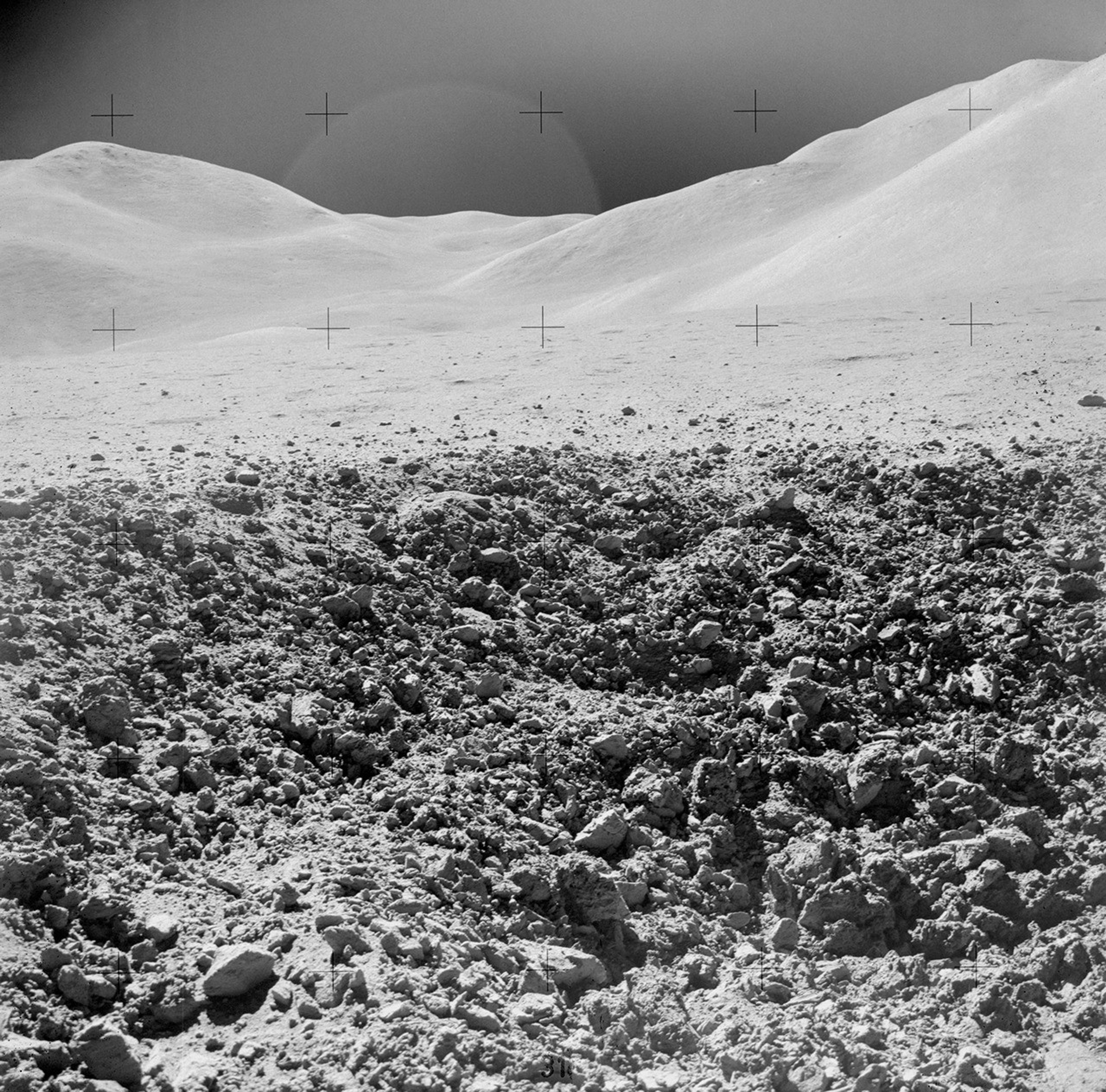
NASA Finds Lunar Regolith Limits Meteorites as Source of Earth’s Water A close-up view of a portion of a “relatively fresh” crater, looking southeast, as photographed during the third Apollo 15 lunar surface moonwalk. Credit: NASAA new NASA study of its Apollo lunar soils clarifies the Moon’s record of meteorite impacts and timing of water delivery. These findings place upper bounds on how much water meteorites could have supplied later in Earth’s history.
Research has previously shown that meteorites may have been a significant source of Earth’s water as they bombarded our planet early in the solar system’s development. In a paper published Tuesday in the Proceedings to the National Academy of Sciences, researchers led by Tony Gargano, a postdoctoral fellow at NASA’s Johnson Space Center and the Lunar and Planetary Institute (LPI), both in Houston, used a novel method for analyzing the dusty debris that covers the Moon’s surface called regolith. They learned that even under generous assumptions, meteorite delivery since about four billion years ago could only have supplied a small fraction of Earth’s water.
The Moon serves as an ancient archive of the impact history the Earth-Moon system has experienced over billions of years. Where Earth’s dynamic crust and weather erase such records, lunar samples preserve them. The records don’t come without challenge, though. Traditional methods of studying regolith have relied on analyzing metal-loving elements. These elements can get muddied by repeated impacts on the Moon, making it harder to untangle and reconstruct what the original meteoroids contained.
Enter triple oxygen isotopes, high precision “fingerprints” that take advantage of the fact that oxygen, the dominant element by mass in rocks, is unaffected by impact or other external forces. The isotopes offer a clearer understanding of the composition of meteorites that impacted the Earth-Moon system. The oxygen-isotope measurements revealed that at least ~1% by mass of the regolith contained material from carbon-rich meteorites that were partially vaporized when they hit the Moon. Using the known properties of such meteorites allowed the team to calculate the amount of water that would have been carried within.
“The lunar regolith is one of the rare places we can still interpret a time-integrated record of what was hitting Earth’s neighborhood for billions of years,” said Gargano. “The oxygen-isotope fingerprint lets us pull an impactor signal out of a mixture that’s been melted, vaporized, and reworked countless times.”
The findings have implications for our understanding of water sources on Earth and the Moon. When scaled up by roughly 20 times to account for the substantially higher rate of impacts on Earth, the cumulative water shown in the model made up only a small percent of the water in Earth’s oceans. That makes it difficult to reconcile the hypothesis that late delivery of water-rich meteorites was the dominant source of Earth’s water.
“Our results don’t say meteorites delivered no water,” added co-author Justin Simon, a planetary scientist at NASA Johnson’s Astromaterials Research and Exploration Science Division. “They say the Moon’s long-term record makes it very hard for late meteorite delivery to be the dominant source of Earth’s oceans.”
For the Moon, the implied delivery since about 4 billion years ago is tiny on an Earth-ocean scale but is not insignificant for the Moon. The Moon’s accessible water inventory is concentrated in small, permanently shadowed regions at the North and South Poles. These are some of the coldest spots in the solar system and introduce unique opportunities for scientific discovery and potential resources for lunar exploration when NASA lands astronauts on the Moon through Artemis III and beyond.
The samples analyzed for this study came from parts of the Moon near the equator on the side of the Moon facing Earth, where all six Apollo missions landed. The rocks and dust collected more than 50 years ago continue to reveal new insights but are constrained to a small portion of the Moon. Samples delivered through Artemis will open the door for a new generation of discoveries for decades to come.
“I’m part of the next generation of Apollo scientists —people who didn’t fly the missions, but who were trained on the samples and the questions Apollo made possible,” said Gargano. “The value of the Moon is that it gives us ground truth: real, physical material we can measure in the lab and use to anchor what we infer from orbital data and telescopes. I can’t wait to see what the Artemis samples have to teach us and the next generation about our place in the solar system.”
For more information on NASA’s Astromaterials Research and Exploration Science Division, visit:
https://science.nasa.gov/astromaterials
Karen Fox / Molly Wasser
Headquarters, Washington
240-285-5155 / 240-419-1732
karen.c.fox@nasa.gov / molly.l.wasser@nasa.gov
Victoria Segovia
NASA’s Johnson Space Center
281-483-5111
victoria.segovia@nasa.gov
Missions
Humans in Space
Climate Change
Solar System
NASA Finds Lunar Regolith Limits Meteorites as Source of Earth’s Water
4 min read
NASA Finds Lunar Regolith Limits Meteorites as Source of Earth’s Water A close-up view of a portion of a “relatively fresh” crater, looking southeast, as photographed during the third Apollo 15 lunar surface moonwalk. Credit: NASAA new NASA study of its Apollo lunar soils clarifies the Moon’s record of meteorite impacts and timing of water delivery. These findings place upper bounds on how much water meteorites could have supplied later in Earth’s history.
Research has previously shown that meteorites may have been a significant source of Earth’s water as they bombarded our planet early in the solar system’s development. In a paper published Tuesday in the Proceedings to the National Academy of Sciences, researchers led by Tony Gargano, a postdoctoral fellow at NASA’s Johnson Space Center and the Lunar and Planetary Institute (LPI), both in Houston, used a novel method for analyzing the dusty debris that covers the Moon’s surface called regolith. They learned that even under generous assumptions, meteorite delivery since about four billion years ago could only have supplied a small fraction of Earth’s water.
The Moon serves as an ancient archive of the impact history the Earth-Moon system has experienced over billions of years. Where Earth’s dynamic crust and weather erase such records, lunar samples preserve them. The records don’t come without challenge, though. Traditional methods of studying regolith have relied on analyzing metal-loving elements. These elements can get muddied by repeated impacts on the Moon, making it harder to untangle and reconstruct what the original meteoroids contained.
Enter triple oxygen isotopes, high precision “fingerprints” that take advantage of the fact that oxygen, the dominant element by mass in rocks, is unaffected by impact or other external forces. The isotopes offer a clearer understanding of the composition of meteorites that impacted the Earth-Moon system. The oxygen-isotope measurements revealed that at least ~1% by mass of the regolith contained material from carbon-rich meteorites that were partially vaporized when they hit the Moon. Using the known properties of such meteorites allowed the team to calculate the amount of water that would have been carried within.
“The lunar regolith is one of the rare places we can still interpret a time-integrated record of what was hitting Earth’s neighborhood for billions of years,” said Gargano. “The oxygen-isotope fingerprint lets us pull an impactor signal out of a mixture that’s been melted, vaporized, and reworked countless times.”
The findings have implications for our understanding of water sources on Earth and the Moon. When scaled up by roughly 20 times to account for the substantially higher rate of impacts on Earth, the cumulative water shown in the model made up only a small percent of the water in Earth’s oceans. That makes it difficult to reconcile the hypothesis that late delivery of water-rich meteorites was the dominant source of Earth’s water.
“Our results don’t say meteorites delivered no water,” added co-author Justin Simon, a planetary scientist at NASA Johnson’s Astromaterials Research and Exploration Science Division. “They say the Moon’s long-term record makes it very hard for late meteorite delivery to be the dominant source of Earth’s oceans.”
For the Moon, the implied delivery since about 4 billion years ago is tiny on an Earth-ocean scale but is not insignificant for the Moon. The Moon’s accessible water inventory is concentrated in small, permanently shadowed regions at the North and South Poles. These are some of the coldest spots in the solar system and introduce unique opportunities for scientific discovery and potential resources for lunar exploration when NASA lands astronauts on the Moon through Artemis III and beyond.
The samples analyzed for this study came from parts of the Moon near the equator on the side of the Moon facing Earth, where all six Apollo missions landed. The rocks and dust collected more than 50 years ago continue to reveal new insights but are constrained to a small portion of the Moon. Samples delivered through Artemis will open the door for a new generation of discoveries for decades to come.
“I’m part of the next generation of Apollo scientists —people who didn’t fly the missions, but who were trained on the samples and the questions Apollo made possible,” said Gargano. “The value of the Moon is that it gives us ground truth: real, physical material we can measure in the lab and use to anchor what we infer from orbital data and telescopes. I can’t wait to see what the Artemis samples have to teach us and the next generation about our place in the solar system.”
For more information on NASA’s Astromaterials Research and Exploration Science Division, visit:
https://science.nasa.gov/astromaterials
Karen Fox / Molly Wasser
Headquarters, Washington
240-285-5155 / 240-419-1732
karen.c.fox@nasa.gov / molly.l.wasser@nasa.gov
Victoria Segovia
NASA’s Johnson Space Center
281-483-5111
victoria.segovia@nasa.gov
Read More
Facebook logo @NASASolarSystem @NASASolarSystem Instagram logo @NASASolarSystem Share Details Last Updated Jan 23, 2026 Related Terms Explore More 4 min read NASA Selects 2 Instruments for Artemis IV Lunar Surface Science
Article
2 months ago
2 min read Join NASA on Oct. 4 in Looking Up, Celebrating Moon
Article
4 months ago
1 min read Help Map the Moon’s Molten Flows!
Article
4 months ago
Keep Exploring Discover Related Topics
Missions
Humans in Space
Climate Change
Solar System
NASA’s Chandra Releases Deep Cut From Catalog of Cosmic Recordings
Like a recording artist who has had a long career, NASA’s Chandra X-ray Observatory has a “back catalog” of cosmic recordings that is impossible to replicate. To access these X-ray tracks, or observations, the ultimate compendium has been developed: the Chandra Source Catalog (CSC).
The CSC contains the X-ray data detected up to the end of 2020 by Chandra, the world’s premier X-ray telescope and one of NASA’s “Great Observatories.” The latest version of the CSC, known as CSC 2.1, contains over 400,000 unique compact and extended sources and over 1.3 million individual detections in X-ray light.
before after This image contains lower-, medium-, and higher-energy X-rays in red, green, and blue respectively. NASA/CXC/SAO; Image Processing: NASA/CXC/SAO/N. Wolk This image is the sum of 86 observations added together, representing over three million seconds of Chandra observing time. It spans just about 60 light-years across, which is a veritable pinprick on the entire sky. The underlying image contains lower-, medium-, and higher-energy X-rays in red, green, and blue respectively. The annotations on the image show where Chandra has detected over 3,300 individual sources in this field of view over a 22-year timeframe.NASA/CXC/SAO; Image Processing: NASA/CXC/SAO/N. Wolk beforeafter This image contains lower-, medium-, and higher-energy X-rays in red, green, and blue respectively. NASA/CXC/SAO; Image Processing: NASA/CXC/SAO/N. Wolk This image is the sum of 86 observations added together, representing over three million seconds of Chandra observing time. It spans just about 60 light-years across, which is a veritable pinprick on the entire sky. The underlying image contains lower-, medium-, and higher-energy X-rays in red, green, and blue respectively. The annotations on the image show where Chandra has detected over 3,300 individual sources in this field of view over a 22-year timeframe.NASA/CXC/SAO; Image Processing: NASA/CXC/SAO/N. Wolk before afterBefore and After
X-ray Images of Sagittarius A*1999 – 2021
CurtainToggle2-Up Image Details This image is the sum of 86 observations added together, representing over three million seconds of Chandra observing time. It spans just about 60 light-years across, which is a veritable pinprick on the entire sky. The underlying image contains lower-, medium-, and higher-energy X-rays in red, green, and blue respectively. The annotations on the image show where Chandra has detected over 3,300 individual sources in this field of view over a 22-year timeframe.Within the CSC, there is a wealth of information gleaned from the Chandra observations — from precise positions on the sky to information about the the X-ray energies detected. This allows scientists using other telescopes — both on the ground and in space including NASA’s James Webb and Hubble Space Telescopes — to combine this unique X-ray data with information from other types of light.
The richness of the Chandra Source Catalog is illustrated in a new image of the Galactic Center, the region around the supermassive black hole at the center of the Milky Way galaxy called Sagittarius A*. In this image that spans just about 60 light-years across, a veritable pinprick on the entire sky, Chandra has detected over 3,300 individual sources that emit X-rays. This image is the sum of 86 observations added together, representing over three million seconds of Chandra observing time.
Another new representation of the vast scope of the Chanda Source Catalog is found in a just-released sonification, the translation of astronomical data into sound. This sonification encompasses the new map that includes 22 years of Chandra observations across the sky, beginning from its launch through its observations in 2021. Because many X-ray sources have been observed multiple times over the life of the Chandra mission, this sonification represents those repeat X-ray sightings over time through different notes.
To view this video please enable JavaScript, and consider upgrading to a web browser that supports HTML5 video
Chandra Source Catalog Sonification.NASA/CXC/SAO/K.Arcand, SYSTEM Sounds (M. Russo, A. SantaguidaIn the view of the sky, projected in a similar way to how the Earth is often depicted in world maps, the core of the Milky Way is in the center and the Galactic plane is horizontal across the middle of the image. A circle appears at the position of each detection and the size of the circle is determined by the number of detections in that location over time. A year counter appears at the top of the frame. Since Chandra continues to be fully operational, the text changes to “… and beyond” after 2021 as the telescope continues to collect observations. During the video, a collage of images produced by Chandra fades in as a background. In the final frames of the video, thumbnail images representing the thousands of Chandra observations taken over the lifetime of the mission appear behind the sky map.
The most recent version of the Chandra Source Catalog can be accessed at https://cxc.cfa.harvard.edu/csc/
NASA’s Marshall Space Flight Center in Huntsville, Alabama, manages the Chandra program. The Smithsonian Astrophysical Observatory’s Chandra X-ray Center controls science operations from Cambridge, Massachusetts, and flight operations from Burlington, Massachusetts.
To learn more about Chandra, visit:
https://science.nasa.gov/chandra
Read more from NASA’s Chandra X-ray Observatory
Learn more about the Chandra X-ray Observatory and its mission here:
Visual DescriptionA very deep Chandra X-ray Observatory image around the Sagittarius A* supermassive black hole, located in the center of the Milky Way galaxy, is shown. The image is dominated by burnt orange, deep gold and blue hues, with a sprinkling of rich green. The area looks both intricate and full, with a dense population of tiny dots, along with larger clumps and diffuse areas and nebulous areas peeking through.
At the center of the image, there is a bright, lumpy area in pale gold showing the intense X-ray radiation emanating from the Sagittarius A* black hole. In the surrounding area, there are more smaller lumps layered throughout, feathering out to a large almost butterfly shape filling much of the screen. The image appears textured, like dozens of blue and orange glow worms are paused in their wriggling.
The image offers an unprecedented view of lobes of hot gas extending for a dozen light years on either side of the black hole. These lobes provide evidence for powerful eruptions occurring several times over the last ten thousand years. The image also contains several mysterious X-ray filaments, some of which may be huge magnetic structures interacting with streams of energetic electrons produced by rapidly spinning neutron stars. Such features are known as pulsar wind nebulas. Chandra has detected over 3,300 individual sources that emit X-rays in this field of view. This image is the sum of 86 observations added together, representing over three million seconds of Chandra observing time.
News Media ContactMegan Watzke
Chandra X-ray Center
Cambridge, Mass.
617-496-7998
mwatzke@cfa.harvard.edu
Joel Wallace
Marshall Space Flight Center, Huntsville, Alabama
256-544-0034
joel.w.wallace@nasa.gov
AMS 2026 Hyperwall Schedule
2 min read
AMS 2026 Hyperwall Schedule106th American Meteorological Society (AMS) Meeting, January 25 – 29, 2026
Join NASA in the Exhibit Hall (Booth #323) for Hyperwall Storytelling by NASA experts. Full Hyperwall Agenda below.
MONDAY, JANUARY 26
6:05 – 6:20 p.m.Expanding Discovery from Earth Science Missions in SpaceHighlights of NASA Earth Science Missions to Advance Research, Data, Models, and Actionable ScienceKaren St. Germain6:20 – 6:35 p..m.Revolutionizing Exploration of the SunJamie Favors6:40 – 6:55 p.m.Space Weather for AstronautsJamie Favors
Gina DiBraccio6:55 – 7:10 p.m.See Global Precipitation Without Writing CodeGeorge Huffman
TUESDAY, JANUARY 27
10:00 – 10:15 a.m.Removing Barriers to Utilizing NASA Research DataPaul Stackhouse10:30 – 10:45 a.m.Connecting Satellite Data to the One Health ApproachHelena Chapman3:00 – 3:15 p.m.New Solar Observations and Solar Wind Measurements From the SOLAR-1 MissionDimitris Vassiliadis3:15 – 3:30 p.m.Aerosols Around the WorldRobert Levy3:30 – 3:45 p.m.NASA’s Mission to the SunEric Christian3:45 – 4:0 p.m.Expanding Discovery from Earth Science Missions in SpaceJulie Robinson4:00 – 4:15 p.m.Explore Space Weather through the Community Coordinated Modeling Center and OpenSpaceElana Resnick5:10 – 5:25 p.m.Think Fast, Think Sun: Exploring NASA’s HelioData for Space-Weather AwarenessAlex Young5:30 – 5:45 p.m.Early Career Research Program: Empowering Emerging TalentYaitza Luna-CruzWEDNESDAY, JANUARY 28
10:00 – 10:15 a.m.NASA Space Weather Year of LaunchesKelly Korreck10:15 – 10:30 a.m.A Bird’s-Eye View of Air Pollution in MegacitiesLaura Judd10:30 – 10:45 a.m.Next-Gen Operational Microwave Sounding Through 2050Edward Kim3:15 – 3:30 p.m.The Ultimate Collab: NASA and NOAA Space WeatherKelly Korreck&
Yaireska (Yari)
Collado-Vega3:30 – 3:45 p.m.See Global Precipitation Without Writing CodeGeorge
Huffman3:45 – 4:00 p.m.From Investment to Impact: How LEO Innovations Benefit UsersJeremy Goldstein4:00 – 4:15 p.m.Early Career Research Program: Empowering Emerging TalentYaitza Luna-Cruz4:15 – 4:30 p.m.Accelerating Health and Air Quality Solutions Through Earth Observations
John Haynes5:10 – 5:25 p.m.The Interstellar Mapping and Acceleration Probe (IMAP)Eric Christian
THURSDAY, JANUARY 29
10:00 – 10:15 a.m.Think Fast, Think Sun: Exploring NASA’s HelioData for Space-Weather AwarenessAlex Young10:30 – 10:45 a.m.From Investment to Impact: How LEO Innovations Benefit UsersJeremy GoldsteinAMS 2026 Hyperwall Schedule
2 min read
AMS 2026 Hyperwall Schedule106th American Meteorological Society (AMS) Meeting, January 25 – 29, 2026
Join NASA in the Exhibit Hall (Booth #323) for Hyperwall Storytelling by NASA experts. Full Hyperwall Agenda below.
MONDAY, JANUARY 26
6:05 – 6:20 p.m. Expanding Discovery from Earth Science Missions in SpaceHighlights of NASA Earth Science Missions to Advance Research, Data, Models, and Actionable Science Karen St. Germain 6:20 – 6:35 p..m. Revolutionizing Exploration of the Sun Jamie Favors 6:40 – 6:55 p.m. Space Weather for Astronauts Jamie Favors
Gina DiBraccio 6:55 – 7:10 p.m. See Global Precipitation Without Writing Code George Huffman
TUESDAY, JANUARY 27
10:00 – 10:15 a.m. Removing Barriers to Utilizing NASA Research Data Paul Stackhouse 10:15 – 10:30 a.m. Earth Data to Action — What’s New with Earth Data? Jim O’Sullivan 10:30 – 10:45 a.m. Connecting Satellite Data to the One Health Approach Helena Chapman 3:00 – 3:15 p.m. New Solar Observations and Solar Wind Measurements From the SOLAR-1 Mission Dimitris Vassiliadis 3:15 – 3:30 p.m. Aerosols Around the World Robert Levy 3:30 – 3:45 p.m. NASA’s Mission to the Sun Eric Christian 3:45 – 4:0 p.m. Expanding Discovery from Earth Science Missions in Space Julie Robinson 4:00 – 4:15 p.m. Explore Space Weather through the Community Coordinated Modeling Center and OpenSpace Elana Resnick 5:10 – 5:25 p.m. Think Fast, Think Sun: Exploring NASA’s HelioData for Space-Weather Awareness Alex Young 5:30 – 5:45 p.m. Early Career Research Program: Empowering Emerging Talent Yaitza Luna-CruzWEDNESDAY, JANUARY 28
10:00 – 10:15 a.m. NASA Space Weather Year of Launches Kelly Korreck 10:15 – 10:30 a.m. A Bird’s-Eye View of Air Pollution in Megacities Laura Judd 10:30 – 10:45 a.m. Next-Gen Operational Microwave Sounding Through 2050 Edward Kim 3:15 – 3:30 p.m. The Ultimate Collab: NASA and NOAA Space Weather Kelly Korreck&
Yaireska (Yari)
Collado-Vega 3:30 – 3:45 p.m. See Global Precipitation Without Writing Code George
Huffman 3:45 – 4:00 p.m. From Investment to Impact: How LEO Innovations Benefit Users Jeremy Goldstein 4:00 – 4:15 p.m. Early Career Research Program: Empowering Emerging Talent Yaitza Luna-Cruz 4:15 – 4:30 p.m. Accelerating Health and Air Quality Solutions through Earth Observations John Haynes 5:10 – 5:25 p.m. The Interstellar Mapping and Acceleration Probe (IMAP) Eric Christian
THURSDAY, JANUARY 29
10:00 – 10:15 a.m. Think Fast, Think Sun: Exploring NASA’s HelioData for Space-Weather Awareness Alex Young 10:30 – 10:45 a.m. From Investment to Impact: How LEO Innovations Benefit Users Jeremy Goldstein