
NASA - Breaking News
NASA’s SpaceX Crew-9 Astronauts to Discuss Science Mission
After completing a long-duration stay aboard the International Space Station, NASA’s SpaceX Crew-9 astronauts will discuss their science mission during a postflight news conference at 2:30 p.m. EDT Monday, March 31, from the agency’s Johnson Space Center in Houston. Following the news conference, the crew will be available for a limited number of individual interviews at 3:30 p.m.
NASA astronauts Nick Hague, Suni Williams, and Butch Wilmore will answer questions about their time in space. The three NASA crew members and Roscosmos cosmonaut Aleksandr Gorbunov returned to Earth on March 18. Gorbunov will not participate in the news conference because of his travel schedule.
Watch live coverage on NASA+. Learn how to watch NASA content through a variety of additional platforms, including social media.
Media are invited to attend in person or virtually. U.S. media requesting in-person attendance or media seeking an interview with the crew must contact the NASA Johnson newsroom no later than 5 p.m. on Friday, March 28, at 281-483-5111 or jsccommu@mail.nasa.gov. A copy of NASA’s media accreditation policy is available on the agency’s website. Media participating by phone must dial into the news conference no later than 10 minutes before the start of the event to ask questions. Questions also may be submitted on social media using #AskNASA.
Hague and Gorbunov lifted off at 1:17 p.m. Sept. 28, 2024, on a SpaceX Falcon 9 rocket from Space Launch Complex 40 at Cape Canaveral Space Force Station in Florida. The next day, they docked to the forward-facing port of the station’s Harmony module. Williams and Wilmore launched aboard Boeing’s Starliner spacecraft and United Launch Alliance Atlas V rocket on June 5, 2024, from Space Launch Complex 41 as part of the agency’s Boeing Crew Flight Test. The duo arrived at the space station on June 6. In August, NASA announced the uncrewed return of Starliner to Earth and integrated Wilmore and Williams as part of the space station’s Expedition 71/72 for a return on Crew-9.
Williams and Wilmore traveled 121,347,491 miles during their mission, spent 286 days in space, and completed 4,576 orbits around Earth. Hague and Gorbunov traveled 72,553,920 miles during their mission, spent 171 days in space, and completed 2,736 orbits around Earth.
Hague, Williams, and Wilmore completed over 900 hours of research, conducting more than 150 unique experiments. During their time in orbit, the crew studied plant growth and development, tested stem cell technology to improve patient outcomes on Earth, and participated in research to understand how the space environment affects material degradation. They also performed a spacewalk and collected samples from the station’s exterior, studying the survivability of microorganisms in space. Additionally, the crew supported 30 ham radio events with students worldwide and conducted a student-led genetic experiment, helping to inspire the next generation of explorers.
NASA’s Commercial Crew Program has delivered on its goal of safe, reliable, and cost-effective transportation to and from the International Space Station from the United States through a partnership with American private industry. This partnership is changing the arc of human spaceflight history by opening access to low Earth orbit and the International Space Station to more people, more science, and more commercial opportunities. The space station remains the springboard to NASA’s next great leap in space exploration, including future missions to the Moon and, eventually, to Mars.
Find more information on NASA’s Commercial Crew Program at:
https://www.nasa.gov/commercialcrew
-end-
Joshua Finch / Jimi Russell
Headquarters, Washington
202-358-1100
joshua.a.finch@nasa.gov / james.j.russell@nasa.gov
Courtney Beasley
Johnson Space Center, Houston
281-483-5111
courtney.m.beasley@nasa.gov
50 Years Ago: Final Saturn Rocket Rolls Out to Launch Pad 39
On March 24, 1975, the last in a long line of super successful Saturn rockets rolled out from the vehicle assembly building to Launch Pad 39B at NASA’s Kennedy Space Center in Florida. The Saturn IB rocket for the Apollo-Soyuz Test Project was the 19th in the Saturn class stacked in the assembly building, beginning in 1966 with the Saturn V 500F facilities checkout vehicle. Thirteen flight Saturn V rockets followed, 12 to launch Apollo spacecraft and one to place the Skylab space station into orbit. In addition, workers stacked four flight Saturn IB rockets, three to launch crews to Skylab and one for Apollo-Soyuz, plus another for the Skylab rescue vehicle that was not needed and never launched. Previously, workers stacked Saturn I and Saturn IB rockets on the pads at Launch Complexes 34 and 37. With the successful liftoff in July 1975, the Saturn family of rockets racked up a 100 percent success rate of 32 launches.
Workers lower the Apollo command and service modules onto the spacecraft adaptor.NASA Technicians in the assembly building replace the fins on the Saturn IB rocket’s first stage. NASA Workers in the assembly building prepare to lower the spacecraft onto its Saturn IB rocket.NASAInspections of the Saturn IB rocket’s first stage fins revealed hairline cracks in several hold-down fittings and managers ordered the replacement of all eight fins. While the cracks would not affect the flight of the rocket they bore the weight of the rocket on the mobile launcher. Workers finished the fin replacement on March 16. Engineers in Kennedy’s spacecraft operations building prepared the Apollo spacecraft for its historic space mission. By early March, they had completed checkout and assembly of the spacecraft and transported it to the assembly building on March 17 to mount it atop the Saturn IB’s second stage. Five days later, they topped off the rocket with the launch escape system.
The final Saturn IB begins its rollout from the vehicle assembly building. NASA The Saturn IB passes by the Launch Control Center. NASA Apollo astronauts Thomas Stafford, left, Vance Brand, and Donald “Deke” Slayton pose in front of their Saturn IB during the rollout.NASAOn March 23, workers edged the mobile transporter carrying the Saturn IB just outside the assembly building’s High Bay 1, where engineers installed an 80-foot tall lightning mast atop the launch tower. The next morning, the stack continued its rollout to Launch Pad 39B with the prime crew of Thomas Stafford, Vance Brand, and Donald “Deke” Slayton and support crew members Robert Crippen and Richard Truly on hand to observe. About 7,500 people, including guests, dependents of Kennedy employees and NASA Tours patrons, watched as the stack moved slowly out of the assembly building on its five-mile journey to the launch pad.
Mission Control in Houston during the joint simulation with Flight Director Donald Puddy in striped shirt and a view of Mission Control in Moscow on the large screen at left. NASA A group of Soviet flight controllers in a support room in Mission Control in Houston during the joint simulation. NASAOn March 20, flight controllers and crews began a series of joint simulations for the joint mission scheduled for July 1975. For the six days of simulations, cosmonauts Aleksei Leonov and Valeri Kubasov and astronauts Stafford, Brand, and Slayton participated in the activity in spacecraft simulators in their respective countries, with both control centers in Houston and outside Moscow fully staffed as if for the actual mission. The exercises simulated various phases of the mission, including the respective launches, rendezvous and docking, crew transfers and joint operations, and undocking.
Astronauts Thomas Stafford, left, Vance Brand, and Donald “Deke” Slayton in a boilerplate Apollo command module preparing for the water egress training. NASA Stafford, left, Slayton, and Brand in the life raft during water egress training. NASAAstronauts Stafford, Brand and Slayton participated in a water egress training activity on March 8, completing the exercise in a water tank in Building 260 at NASA’s Johnson Space Center in Houston. The astronauts practiced egressing from their spacecraft onto a lift raft and being lifted up with the use of a Billy Pugh rescue net. They practiced wearing their flight coveralls as well as their spacesuits.
Explore More 5 min read 50 Years Ago: Preparing the Final Saturn Rocket for Flight Article 2 months ago 6 min read 45 Years Ago: Soyuz and Apollo Launch Article 5 years ago 8 min read 45 Years Ago: Historic Handshake in Space Article 5 years agoNASA’s Webb Telescope Unmasks True Nature of the Cosmic Tornado
- Webb
- News
- Overview
- Science
- Observatory
- Multimedia
- Team
- More
Craving an ice cream sundae with a cherry on top? This random alignment of Herbig-Haro 49/50 — a frothy-looking outflow from a nearby protostar — with a multi-hued spiral galaxy may do the trick. This new composite image combining observations from NASA’s James Webb Space Telescope’s NIRCam (Near-Infrared Camera) and MIRI (Mid-Infrared Instrument) provides a high-resolution view to explore the exquisite details of this bubbling activity.
Herbig-Haro objects are outflows produced by jets launched from a nearby, forming star. The outflows, which can extend for light-years, plow into a denser region of material. This creates shock waves, heating the material to higher temperatures. The material then cools by emitting light at visible and infrared wavelengths.
Image A:Herbig-Haro 49/50 (NIRCam and MIRI Image) NASA’s James Webb Space Telescope observed Herbig-Haro 49/50, an outflow from a nearby still-forming star, in high-resolution near- and mid-infrared light. The intricate features of the outflow, represented in reddish-orange color, provide detailed clues about how young stars form and how their jet activity affects the environment around them. Like the wake of a speeding boat, the bow shocks in this image have an arc-like appearance as the fast-moving jet from the young star slams into the surrounding dust and gas. A chance alignment in this direction of the sky provides a beautiful juxtaposition of this nearby Herbig-Haro object with a more distant spiral galaxy in the background. Herbig-Haro 49/50 gives researchers insights into the early phases of the formation of low-mass stars similar to our own Sun. In this Webb image, blue represents light at 2.0-microns (F200W), cyan represents light at 3.3-microns (F335M), green is 4.4-microns (F444W), orange is 4.7-microns (F470N), and red is 7.7-microns (F770W).NASA, ESA, CSA, STScI
When NASA’s retired Spitzer Space Telescope observed it in 2006, scientists nicknamed Herbig-Haro 49/50 (HH 49/50) the “Cosmic Tornado” for its helical appearance, but they were uncertain about the nature of the fuzzy object at the tip of the “tornado.” With its higher imaging resolution, Webb provides a different visual impression of HH 49/50 by revealing fine features of the shocked regions in the outflow, uncovering the fuzzy object to be a distant spiral galaxy, and displaying a sea of distant background galaxies.
Image B:Herbig-Haro 49/50 (Spitzer and Webb Images Side-by-Side) This side-by-side comparison shows a Spitzer Space Telescope Infrared Array Camera image of HH 49/50 (left) versus a Webb image of the same object (right) using the NIRCam (Near-infrared Camera) instrument and MIRI (Mid-infrared Instrument). The Webb image shows intricate details of the heated gas and dust as the protostellar jet slams into the material. Webb also resolves the “fuzzy” object located at the tip of the outflow into a distant spiral galaxy. The Spitzer image shows 3.6-micron light in blue, the 4.5-micron in green, and the 8.0-micron in red (IRAC1, IRAC2, IRAC4). In the Webb image, blue represents light at 2.0-microns (F200W), cyan represents light at 3.3-microns (F335M), green is 4.4-microns (F444W), orange is 4.7-microns (F470N), and red is 7.7-microns (F770W).NASA, ESA, CSA, STScI, NASA-JPL, SSC
HH 49/50 is located in the Chamaeleon I Cloud complex , one of the nearest active star formation regions in our Milky Way, which is creating numerous low-mass stars similar to our Sun. This cloud complex is likely similar to the environment that our Sun formed in. Past observations of this region show that the HH 49/50 outflow is moving away from us at speeds of 60-190 miles per second (100-300 kilometers per second) and is just one feature of a larger outflow.
Webb’s NIRCam and MIRI observations of HH 49/50 trace the location of glowing hydrogen molecules, carbon monoxide molecules, and energized grains of dust, represented in orange and red, as the protostellar jet slams into the region. Webb’s observations probe details on small spatial scales that will help astronomers to model the properties of the jet and understand how it is affecting the surrounding material.
The arc-shaped features in HH 49/50, similar to a water wake created by a speeding boat, point back to the source of this outflow. Based on past observations, scientists suspect that a protostar known as Cederblad 110 IRS4 is a plausible driver of the jet activity. Located roughly 1.5 light-years away from HH 49/50 (off the lower right corner of the Webb image), CED 110 IRS4 is a Class I protostar. Class I protostars are young objects (tens of thousands to a million years old) in the prime time of gaining mass. They usually have a discernable disk of material surrounding them that is still falling onto the protostar. Scientists recently used Webb’s NIRCam and MIRI observations to study this protostar and obtain an inventory of the icy composition of its environment.
These detailed Webb images of the arcs in HH 49/50 can more precisely pinpoint the direction to the jet source, but not every arc points back in the same direction. For example, there is an unusual outcrop feature (at the top right of the main outflow) which could be another chance superposition of a different outflow, related to the slow precession of the intermittent jet source. Alternatively, this feature could be a result of the main outflow breaking apart.
Video Caption:This visualization examines the three-dimensional structure of Herbig-Haro 49/50 (HH 49/50) as seen in near- and mid-infrared light by the James Webb Space Telescope. HH 49/50 is an outflow produced by the jet of a nearby still-forming star in the Chamaeleon I Cloud complex, one of the nearest active star formation regions in our Milky Way. At a distance of 625 light-years from Earth, this new composite infrared image (using data from program 6558, PI: M. Garcia Marin) allows researchers to examine its details on small spatial scales like never before.
Visualization Credit: NASA, ESA, CSA, J. DePasquale (STScI), L. Hustak (STScI), G. Bacon (STScI), R. Crawford (STScI), D. Kirshenblat (STScI), C. Nieves (STScI), A. Pagan (STScI), F. Summers (STScI).
The galaxy that appears by happenstance at the tip of HH 49/50 is a much more distant, face-on spiral galaxy. It has a prominent central bulge represented in blue that shows the location of older stars. The bulge also shows hints of “side lobes” suggesting that this could be a barred-spiral galaxy. Reddish clumps within the spiral arms show the locations of warm dust and groups of forming stars. The galaxy even displays evacuated bubbles in these dusty regions, similar to nearby galaxies observed by Webb as part of the PHANGS program.
Webb has captured these two unassociated objects in a lucky alignment. Over thousands of years, the edge of HH 49/50 will move outwards and eventually appear to cover up the distant galaxy.
Want more? Take a closer look at the image, “fly through” it in a visualization, and compare Webb’s image to the Spitzer Space Telescope’s.
Herbig-Haro 49/50 is located about 625 light-years from Earth in the constellation Chamaeleon.
The James Webb Space Telescope is the world’s premier space science observatory. Webb will solve mysteries in our solar system, look beyond to distant worlds around other stars, and probe the mysterious structures and origins of our universe and our place in it. Webb is an international program led by NASA with its partners, ESA (European Space Agency) and the Canadian Space Agency.
DownloadsClick any image to open a larger version.
View/Download all image products at all resolutions for this article from the Space Telescope Science Institute.
Media ContactsLaura Betz – laura.e.betz@nasa.gov
NASA’s Goddard Space Flight Center, Greenbelt, Md.
Quyen Hart – qhart@stsci.edu
Space Telescope Science Institute, Baltimore, Md.
Christine Pulliam – cpulliam@stsci.edu
Space Telescope Science Institute, Baltimore, Md.
Images – Webb images of other protostar outflows – L483, HH 46/47, and HH 211
Animation Video – “Exploring Star and Planet Formation”
Interactive – Explore the jets emitted by young stars in multiple wavelengths: ViewSpace Interactive
Article – Read more about Herbig-Haro objects
Related For Kids En Español Keep Exploring Related Topics James Webb Space TelescopeWebb is the premier observatory of the next decade, serving thousands of astronomers worldwide. It studies every phase in the…
Stars
Galaxies
Universe
Share Details Last Updated Mar 24, 2025 EditorStephen SabiaContactLaura Betzlaura.e.betz@nasa.gov Related Terms60 Years Ago: Gemini III, America’s First Two-Person Flight
On March 23, 1965, the United States launched the Gemini III spacecraft with astronauts Virgil “Gus” Grissom and John Young aboard, America’s first two-person spaceflight. Grissom earned the honor as the first person to enter space twice and Young as the first member of the second group of astronauts to fly in space. During their three-orbit flight they carried out the first orbital maneuvers of a crewed spacecraft, a critical step toward demonstrating rendezvous and docking. Grissom and Young brought Gemini 3 to a safe splashdown in the Atlantic Ocean. Their ground-breaking mission led the way to nine more successful Gemini missions in less than two years to demonstrate the techniques required for a Moon landing. Gemini 3 marked the last spaceflight controlled from Cape Kennedy, that function shifting permanently to a new facility in Houston.
In one of the first uses of the auditorium at the Manned Spacecraft Center, now NASA’s Johnson Space Center in Houston, managers announce the prime and backup Gemini III crews. NASA NASA astronauts Virgil “Gus” Grissom and John Young, the Gemini III prime crew. NASA Grissom, foreground, and Young in their capsule prior to launch.NASAOn April 13, 1964, just five days after the uncrewed Gemini I mission, in the newly open auditorium at the Manned Spacecraft Center, now NASA’s Johnson Space Center in Houston, Director Robert Gilruth introduced the Gemini III crew to the press. NASA assigned Mercury 4 veteran Grissom and Group 2 astronaut Young as the prime crew, with Mercury 8 veteran Walter Schirra and Group 2 astronaut Thomas Stafford serving as their backups. The primary goals of Project Gemini included proving the techniques required for the Apollo Program to fulfil President John F. Kennedy’s goal of landing a man on the Moon and returning him safely to Earth before the end of the 1960s. Demonstrating rendezvous and docking between two spacecraft ranked as a high priority for Project Gemini.
Liftoff of Gemini III.NASAThe uncrewed Gemini I and II missions validated the spacecraft’s design, reliability, and heat shield, clearing the way to launch Gemini III with a crew. On March 23, 1965, after donning their new Gemini spacesuits, Grissom and Young rode the transfer van to Launch Pad 19 at Cape Kennedy in Florida. They rode the elevator to their Gemini spacecraft atop its Titan II rocket where technicians assisted them in climbing into the capsule. At 9:24 a.m. EST, the Titan’s first stage engines ignited, and Gemini III rose from the launch pad.
The Mission Control Center at Cape Kennedy in Florida during Gemini III, controlling a human spaceflight for the final time.NASA The Mission Control Center at the Manned Spacecraft Center, now NASA’s Johnson Space Center in Houston, monitoring the Gemini III mission.NASAFive and a half minutes after launch, the Titan II’s second stage engine cut off and the spacecraft separated to begin its orbital journey. Grissom became the first human to enter space a second time. While engineers monitored the countdown from the Launch Pad 19 blockhouse, once in orbit flight controllers in the Mission Control Center at the Cape took over. Controllers in the new Mission Control Center at the Manned Spacecraft Center, now the Johnson Space Center in Houston, staffed consoles and monitored the mission in a backup capacity. Beginning with Gemini IV, control of all American human spaceflights shifted permanently to the Houston facility.
Gemini III entered an orbit of 100 miles by 139 miles above the Earth. Near the end of the first orbit, while passing over Texas, Grissom and Young fired their spacecraft’s thrusters for one minute, 14 seconds. “They appear to be firing good,” said Young, confirming the success of the maneuver. The change in velocity adjusted their orbit to 97 miles by 105 miles. A second burn 45 minutes later altered the orbital inclination by 0.02 degrees. Another task for the crew involved testing new food and packaging developed for Gemini. As an off-the-menu item, Young had stowed a corned beef on rye sandwich in his suit pocket before flight, and both he and Grissom took a bite before stowing it away, concerned about crumbs from the sandwich floating free in the cabin.
Shortly after splashdown, Gemini III astronaut Virgil “Gus” Grissom exits the spacecraft as crewmate John Young waits in the life raft. NASA Sailors hoist the Gemini III spacecraft aboard the prime recovery ship U.S.S. Intrepid.NASA Young, left, and Grissom stand with their spacecraft aboard Intrepid. NASANear the end of their third revolution, Grissom and Young prepared for the retrofire burn to bring them out of orbit. They oriented Gemini III with its blunt end facing forward and completed a final orbital maneuver to lower the low point of their orbit to 45 miles, ensuring reentry even if the retrorockets failed to fire. They jettisoned the rearmost adapter section, exposing the retrorockets that fired successfully, bringing the spacecraft out of orbit. They jettisoned the retrograde section, exposing Gemini’s heat shield. Minutes later, they encountered the upper layers of Earth’s atmosphere at 400,000 feet, and he buildup of ionized gases caused a temporary loss of communication between the spacecraft and Mission Control. At 50,000 feet, Grissom deployed the drogue parachute to stabilize and slow the spacecraft, followed by the main parachute at 10,600 feet. Splashdown occurred in the Atlantic Ocean near Grand Turk Island, about 52 miles short of the planned point, after a flight of 4 hours, 52 minutes, 31 seconds.
Gemini III astronauts Virgil “Gus” Grissom, left, and John Young upon their return to Cape Kennedy in Florida. NASA Grissom and Young at the postflight press conference. NASA The welcome home ceremony for Grissom and Young at the Manned Spacecraft Center, now NASA’s Johnson Space Center in Houston.NASAA helicopter recovered Grissom and Young and delivered them to the deck of the U.S.S. Intrepid, arriving there one hour and 12 minutes after splashdown. On board the carrier, the astronauts received a medical checkup and a telephone call from President Lyndon B. Johnson. The ship sailed to pick up the spacecraft and sailors hoisted it aboard less than three hours after landing. The day after splashdown, Grissom and Young flew to Cape Kennedy for debriefings, a continuation of the medical examinations begun on the carrier, and a press conference. Following visits to the White House, New York, and Chicago, the astronauts returned home to Houston on March 31. The next day, Gilruth welcomed them back to the Manned Spacecraft Center, where in front of the main administration building, workers raised an American flag that Grissom and Young had carried on their mission. That flag flew during every subsequent Gemini mission.
During the Gemini III welcome home ceremony in front of the main administration building at the Manned Spacecraft Center, now NASA’s Johnson Space Center in Houston, workers raise an American flag that the astronauts had carried on their mission. NASA Explore More 5 min read 60 Years Ago: Gemini 1 Flies a Successful Uncrewed Test Flight Article 12 months ago 6 min read 60 Years Ago: Uncrewed Gemini 2 Paves the Way for the First Crewed Mission Article 2 months ago 6 min read Artemis I Mission Control at a Glance Article 3 years agoSols 4486-4487: Ankle-Breaking Kind of Terrain!
- Curiosity Home
- Science
- News and Features
- Multimedia
- Mars Missions
- Mars Home
3 min read
Sols 4486-4487: Ankle-Breaking Kind of Terrain! NASA’s Mars rover Curiosity acquired this image using its Front Hazard Avoidance Camera (Front Hazcam) on March 18, 2025 — sol 4484, or Martian day 4,484 of the Mars Science Laboratory mission — at 11:54:13 UTC.NASA/JPL-CaltechWritten by Catherine O’Connell-Cooper, Planetary Geologist at University of New Brunswick
Earth planning date: Wednesday, March 19, 2025
This terrain is a tricky drive, with rocks angled chaotically all around. One of our geologists remarked that they wouldn’t like to even walk over this without solid boots coming way up over the ankles — this is definitely the kind of terrain to result in twisted and broken ankles! So it wasn’t too unexpected that the drive we had planned on Monday cut short after 18 meters (about 59 feet). Fortunately, we ended up both at a workspace with abundant bedrock and in an orientation that allowed us to pass SRAP (our “Slip Risk Assessment Process”).
The rover planners were quickly able to find a spot to brush, so we have a coordinated target on “Palm Grove,” one of the laminated rocks in the lower half of the accompanying image. APXS and MAHLI will look at this target on the first sol of the plan, and then ChemCam LIBS and Mastcam will look at it on the second sol. Although the bulk of the bedrock is relatively nodule free, ChemCam will look at the nodular target “Refugio” to compare to the more dominant, nodule-poor bedrock.
On Monday, our workspace included some very interesting layers in the bedrock that might represent preserved sand ripples, but sadly, as Conor reported on Monday, we didn’t pass SRAP, which precluded any contact science. However, today we ended up near rocks that had similar layer geometry, and will acquire a MAHLI “Dog’s Eye” or mosaic image of these rocks at “Duna Vista” and two Mastcam 5×3 mosaics (“Bayside Trail” and “Oso Flaco”) on other examples.
Mastcam is taking several other images here. A 14×3 mosaic will capture the “nearfield” or area close to the rover, and a set of four further images focus on four distinct trough features, to help us better understand ongoing modification of the surface. Further afield, the “Quartz Hill” and “Pino Alto” mosaics look at areas of fragmented bedrock which may be similar to the “Humber Park” outcrop we analyzed this past weekend. Even further from the rover, ChemCam will acquire RMI (Remote Micro Imager) images of the “Boxworks” and an almost circular depression (“Torote Bowl”) whose origin is not clear.
The environmental theme group (ENV) planned a Mastcam tau (to look at dust in the atmosphere) and a Navcam dust-devil survey (to look for dust devils!) for the first sol of the plan. On the second sol, we fill out the movies with Navcam movies looking toward the south of the crater (suprahorizon, cloud shadow, and zenith movies) and a Mastcam sky survey.
In between the movies on the second sol, our drive is planned to take us another 34 meters (about 112 feet)… but we will have to see how far our intrepid rover will make it on this tricky terrain. Slow and steady will win this race!
Share Details Last Updated Mar 21, 2025 Related Terms Explore More 3 min read Shocking Spherules! Article 2 hours ago 4 min read Sols 4484-4485: Remote Sensing on a Monday Article 1 day ago 2 min read Sols 4481-4483: Humber Pie Article 3 days ago Keep Exploring Discover More Topics From NASA MarsMars is the fourth planet from the Sun, and the seventh largest. It’s the only planet we know of inhabited…
All Mars ResourcesExplore this collection of Mars images, videos, resources, PDFs, and toolkits. Discover valuable content designed to inform, educate, and inspire,…
Rover BasicsEach robotic explorer sent to the Red Planet has its own unique capabilities driven by science. Many attributes of a…
Mars Exploration: Science GoalsThe key to understanding the past, present or future potential for life on Mars can be found in NASA’s four…
Shocking Spherules!
- Perseverance Home
- Science
- News and Features
- Multimedia
- Mars Missions
- Mars Home
3 min read
Shocking Spherules!Written by Alex Jones, Ph.D. candidate at Imperial College London
Last week the Perseverance Science Team were astonished by a strange rock comprised of hundreds of millimeter-sized spheres… and the team are now working hard to understand their origin.
This image from NASA’s Mars Perseverance rover, a fusion-processed SuperCam Remote Micro Imager (RMI) mosaic, shows part of the “St. Pauls Bay” target, acquired from the lower Witch Hazel Hill area of the Jezero crater rim. The image reveals hundreds of strange, spherical-shaped objects comprising the rock. Perseverance acquired this image on March 11, 2025, or sol 1442 — Martian day 1,442 of the Mars 2020 mission.NASA/JPL-Caltech/LANL/CNES/IRAP.It has now been two weeks since Perseverance arrived at Broom Point, situated at the lower slopes of the Witch Hazel Hill area, on the Jezero crater rim. Here, a series of light- and dark- toned bands were visible from orbit, and just last week the rover successfully abraded and sampled one of the light-toned beds. It was from this sampling workspace where Perseverance spied a very strange texture in a nearby rock…
The rock, named “St. Pauls Bay” by the team, appeared to be comprised of hundreds of millimeter-sized, dark gray spheres. Some of these occurred as more elongate, elliptical shapes, while others possessed angular edges, perhaps representing broken spherule fragments. Some spheres even possessed tiny pinholes! What quirk of geology could produce these strange shapes?
This isn’t the first time strange spheres have been spotted on Mars. In 2004, the Mars Exploration Rover Opportunity spotted so-called, “Martian Blueberries” at Meridiani Planum, and since then, the Curiosity rover has observed spherules in the rocks of Yellowknife Bay at Gale crater. Just a few months ago, Perseverance itself also spied popcorn-like textures in sedimentary rocks exposed in the Jezero crater inlet channel, Neretva Vallis. In each of these cases, the spherules were interpreted as concretions, features that formed by interaction with groundwater circulating through pore spaces in the rock. Not all spherules form this way, however. They also form on Earth by rapid cooling of molten rock droplets formed in a volcanic eruption, for instance, or by the condensation of rock vaporized by a meteorite impact.
NASA’s Mars Perseverance rover acquired this image of the “St. Pauls Bay” target (the dark-toned float block in the right of the view) using its Left Mastcam-Z camera, one of a pair of cameras located high on the rover’s remote-sensing mast. Perseverance acquired this image on March 13, 2025 — sol 1444, or Martian day 1,444 of the Mars 2020 mission — at the local mean solar time of 11:57:49.NASA/JPL-Caltech/ASUEach of these formation mechanisms would have vastly different implications for the evolution of these rocks, so the team is working hard to determine their context and origin. St. Pauls Bay, however, was float rock — a term used by geologists to describe something that is not in-place. The team are now working to link the spherule-rich texture observed at St. Pauls Bay to the wider stratigraphy at Witch Hazel Hill, and initial observations have provided tantalizing indications that it could be linked to one of the dark-toned layers identified by the team from orbit. Placing these features in geologic context will be critical for understanding their origin, and determining their significance for the geological history of the Jezero crater rim and beyond!
Share Details Last Updated Mar 23, 2025 Related Terms Explore More 3 min read Sols 4486-4487: Ankle-Breaking Kind of Terrain! Article 1 day ago 4 min read Sols 4484-4485: Remote Sensing on a Monday Article 2 days ago 2 min read Sols 4481-4483: Humber Pie Article 4 days ago Keep Exploring Discover More Topics From NASA MarsMars is the fourth planet from the Sun, and the seventh largest. It’s the only planet we know of inhabited…
All Mars ResourcesExplore this collection of Mars images, videos, resources, PDFs, and toolkits. Discover valuable content designed to inform, educate, and inspire,…
Rover BasicsEach robotic explorer sent to the Red Planet has its own unique capabilities driven by science. Many attributes of a…
Mars Exploration: Science GoalsThe key to understanding the past, present or future potential for life on Mars can be found in NASA’s four…
CAS Discovery and Foresight
4 min read
Preparations for Next Moonwalk Simulations Underway (and Underwater) A NASA researcher and innovation architect from the Convergent Aeronautics Solutions project Discovery team collaborating at a whiteboard during a visit to Chapel Hill, N.C. on Aug. 13, 2024.NASA / Ariella KnightConvergent Aeronautics Solutions (CAS) Discovery identifies problems worth solving for the benefit of all.
We formulate “convergent” problems—across multiple disciplines and sectors—and build footholds toward potentially transformative opportunities in aeronautics. As aeronautics rapidly advances, it is increasingly intersecting with other sectors like energy, healthcare, emergency response, economic resilience, the space economy, and more.
CAS Discovery builds new innovation tools and methods, a workforce adept at innovation methods, and transdisciplinary teams of researchers within and beyond NASA that conduct regular “Discovery sprints”—expeditions into cross-sector topic areas that could beneficially transform aeronautics and humanity.
WHAT is Discovery? ParticipatoryIt is difficult to understand and effectively address stakeholders’ needs & capabilities without engaging them. Discovery, in consultation with key NASA offices and other government agencies, has honed mechanisms to lawfully and respectfully engage and invite participation from stakeholders, communities, industry, NGOs and government to collaboratively formulate complex societal challenges tied to aviation.
ConvergentTypical organizational structures limit convergence across knowledge boundaries. CAS Discovery is intentionally cross-sector and transdisciplinary because the most impactful ideas often lie at the intersection of boundaries, the borderlands where multiple disciplines and communities come together. We work to emerge multi-sector, system-of-systems challenges that integrate political, economic, social, technological, environmental, legal and ethical trends, needs, and capabilities.
Future-FocusedOrganizations have a tendency of being driven by short-term thinking and relatively short time horizons. CAS Discovery uses strategic foresight methods to examine 20 to 50-year time horizons, systematically ingesting and synthesizing signals and trends from aero and non-aero sources to envision a variety of scenarios to uncover opportunities for the future of aeronautics.
EcosystemicWe study the ecosystems that are part of aeronautics and aerospace. This helps in broadening consideration of impacts while practicing foresight. It enhances our awareness of the environment and gives stakeholders the ability to see ripple effects across technologies, economies, communities, etc. We seek to benefit the wellness of the entire ecosystem while also benefiting the constituents.
A group of NASA researchers and leaders from the Convergent Aeronautics Solutions project Discovery team at the agency’s Glenn Research Center in Cleveland, on April 30, 2024.NASA / Ricaurte Chock WHO is Discovery? NASA ResearchersThey are the engine that propels CAS Discovery. Our cross-center Discovery sprint and foresight teams are composed of researchers from NASA’s Ames Research Center and Armstrong Flight Research Center in California, Glenn Research Center in Cleveland, and Langley Research Center in Virginia.
Researchers from Outside of NASAThey collaborate with us as subject matter experts or Discovery sprint team members to contribute their backgrounds in fields less common within NASA, such as energy, economics, anthropology, and other areas. This collaboration happens through many mechanisms, such as freelancing, crowdsourcing, interviews, webinars, and podcasts.
StakeholdersThey are engaged in various ways and to different degrees, often co-envisioning potential futures, co-formulating problems, and co-designing solutions.
Innovation ArchitectsThey are the glue that holds CAS Discovery together and the anti-glue that keeps our teams from getting stuck. They come from a wide range of experience, each bringing deep expertise in leading transdisciplinary teams and stakeholders through processes and methods from strategic foresight, complex systems design, human-centered design, and more.
CAS Center Integration Leads (CILs)They work with NASA line management at each Aeronautics center to bring NASA researchers and potential new PIs into CAS. CILs also host annual Wicked Wild idea pitch events to bring new problem areas and solution ideas into CAS Discovery and early Execution phases.
- Ames Research Center CIL: Ty Huang
- Armstrong Flight Research Center CIL: Matt Kearns
- Glenn Research Center CIL: Jeffrey Chin
- Langley Research Center CIL: Devin Pugh-Thomas
They oversee Discovery sprint and strategic foresight teams, topics, and processes; new tools and continuous improvement experiments; and the overall health of the CAS innovation front-end pipeline and related strategic outputs.
- Discovery Lead: Eric Reynolds Brubaker, Langley Research Center
- Foresight Lead: Vikram Shyam, Glenn Research Center
COMING SOON: Links to Technical Memorandums and conference papers.
Facebook logo @NASA@NASAaero@NASA_es @NASA@NASAaero@NASA_es Instagram logo @NASA@NASAaero@NASA_es Linkedin logo @NASA Explore More 2 min read NASA Concludes Wind Study Article 2 years ago 3 min read NASA Armstrong Supports Wind Study Article 2 years ago 4 min read NASA Interns Help Identify Aviation Solutions to Health Care Challenges Article 2 years ago Keep Exploring Discover More Topics From NASAConvergent Aeronautics Solutions
Science Missions
Aeronautics STEM
Explore NASA’s History
Share Details Last Updated Mar 21, 2025 EditorJim BankeContactDiana Fitzgeralddiana.r.fitzgerald@nasa.gov Related TermsNASA to Launch Three Rockets from Alaska in Single Aurora Experiment
4 min read
NASA to Launch Three Rockets from Alaska in Single Aurora ExperimentThree NASA-funded rockets are set to launch from Poker Flat Research Range in Fairbanks, Alaska, in an experiment that seeks to reveal how auroral substorms affect the behavior and composition of Earth’s far upper atmosphere.
The experiment’s outcome could upend a long-held theory about the aurora’s interaction with the thermosphere. It may also improve space weather forecasting, critical as the world becomes increasingly reliant on satellite-based devices such as GPS units in everyday life.
Colorful ribbons of aurora sway with geomagnetic activity above the launch pads of Poker Flat Research Range.NASA/Rachel LenseThe University of Alaska Fairbanks (UAF) Geophysical Institute owns Poker Flat, located 20 miles north of Fairbanks, and operates it under a contract with NASA’s Wallops Flight Facility in Virginia, which is part of NASA’s Goddard Space Flight Center in Greenbelt, Maryland.
The experiment, titled Auroral Waves Excited by Substorm Onset Magnetic Events, or AWESOME, features one four-stage rocket and two two-stage rockets all launching in an approximately three-hour period.
Colorful vapor tracers from the largest of the three rockets should be visible across much of northern Alaska. The launch window is March 24 through April 6.
The mission, led by Mark Conde, a space physics professor at UAF, involves about a dozen UAF graduate student researchers at several ground monitoring sites in Alaska at Utqiagvik, Kaktovik, Toolik Lake, Eagle, and Venetie, as well as Poker Flat. NASA delivers, assembles, tests, and launches the rockets.
“Our experiment asks the question, when the aurora goes berserk and dumps a bunch of heat in the atmosphere, how much of that heat is spent transporting the air upward in a continuous convective plume and how much of that heat results in not only vertical but also horizontal oscillations in the atmosphere?” Conde said.
Confirming which process is dominant will reveal the breadth of the mixing and the related changes in the thin air’s characteristics.
“Change in composition of the atmosphere has consequences,” Conde said. “And we need to know the extent of those consequences.”
Most of the thermosphere, which reaches from about 50 to 350 miles above the surface, is what scientists call “convectively stable.” That means minimal vertical motion of air, because the warmer air is already at the top, due to absorption of solar radiation.
A technician with NASA’s Wallops Flight Facility sounding rocket office works on one of the payload sections of the rocket that will launch for the AWESOME campaign.NASA/Lee WingfieldWhen auroral substorms inject energy and momentum into the middle and lower thermosphere (roughly 60 to 125 miles up), it upsets that stability. That leads to one prevailing theory — that the substorms’ heat is what causes the vertical-motion churn of the thermosphere.
Conde believes instead that acoustic-buoyancy waves are the dominant mixing force and that vertical convection has a much lesser role. Because acoustic-buoyancy waves travel vertically and horizontally from where the aurora hits, the aurora-caused atmospheric changes could be occurring over a much broader area than currently believed.
Better prediction of impacts from those changes is the AWESOME mission’s practical goal.
“I believe our experiment will lead to a simpler and more accurate method of space weather prediction,” Conde said.
Two two-stage, 42-foot Terrier-Improved Malemute rockets are planned to respectively launch about 15 minutes and an hour after an auroral substorm begins. A four-stage, 70-foot Black Brant XII rocket is planned to launch about five minutes after the second rocket.
The first two rockets will release tracers at altitudes of 50 and 110 miles to detect wind movement and wave oscillations. The third rocket will release tracers at five altitudes from 68 to 155 miles.
Pink, blue, and white vapor traces should be visible from the third rocket for 10 to 20 minutes. Launches must occur in the dawn hours, with sunlight hitting the upper altitudes to activate the vapor tracers from the first rocket but darkness at the surface so ground cameras can photograph the tracers’ response to air movement.
By Rod Boyce
University of Alaska Fairbanks Geophysical Institute
NASA Media Contact: Sarah Frazier
Share Details Last Updated Mar 21, 2025 Related Terms Explore More 2 min read Hubble Captures a Neighbor’s Colorful Clouds Article 7 hours ago 11 min read The Earth Observer Editor’s Corner: January–March 2025 Article 24 hours ago 5 min read Celebrating 25 Years of Terra Article 24 hours ago Keep Exploring Discover Related TopicsMissions
Humans in Space
Climate Change
Solar System
NASA Reveals Semifinalists of Power to Explore Challenge
4 min read
NASA Reveals Semifinalists of Power to Explore Challenge A word cloud showing “superpowers” of the 45 semifinalists.NASA/David LamNASA selected 45 student essays as semifinalists of its 2024-2025 Power to Explore Challenge, a national competition for K-12 students featuring the enabling power of radioisotopes. Contestants were challenged to explore how NASA has powered some of its most famous science missions and to dream up how their personal “superpower” would energize their success on their own radioisotope-powered science mission to explore one of the nearly 300 moons of our solar system.
The competition asked students to learn about radioisotope power systems (RPS), a type of “nuclear battery” that NASA uses to explore the harshest, darkest, and dustiest parts of our solar system. RPS have enabled many spacecraft to explore a variety of these moons, some with active volcanoes, methane lakes, and intricate weather patterns similar to Earth. Many of these moons remain a mystery to us.
This year’s submissions to NASA’s Power to Explore Challenge were immensely enthralling, and we’re thrilled that the number of entries reached a record high.Carl Sandifer II
Program Manager, NASA Radioisotope Power Systems Program
In 275 words or less, students wrote about a mission of their own that would use these space power systems to explore any moon in our solar system and described their own power to achieve their mission goals.
The Power to Explore Challenge offered students the opportunity to learn more about these reliable power systems, celebrate their own strengths, and interact with NASA’s diverse workforce. This year’s contest set a record, receiving 2,051 submitted entries from all 50 states, Guam, U.S. Virgin Islands, American Samoa, Northern Mariana Islands, Puerto Rico, and the Department of Defense Education Activity (DoDEA) Overseas.
“This year’s submissions to NASA’s Power to Explore Challenge were immensely enthralling, and we’re thrilled that the number of entries reached a record high,” said Carl Sandifer II, program manager of the Radioisotope Power Systems Program at NASA’s Glenn Research Center in Cleveland. “It was particularly interesting to see which moons the students selected for their individual essays, and the mysteries they hope to unravel. Their RPS-powered mission concepts always prove to be innovative, and it’s a joy to learn about their ‘superpowers’ that exemplify their path forward as the next generation of explorers.”
Entries were split into three categories: grades K-4, 5-8, and 9-12. Every student who submitted an entry received a digital certificate, and over 4,859 participants who signed up received an invitation to the Power Up with NASA virtual event. Students learned about what powers the NASA workforce utilizes to dream big and work together to explore. Speakers included Carl Sandifer II, Dr. Wanda Peters, NASA’s deputy associate administrator for programs in the Science Mission Directorate and Dr. Zibi Turtle, principal investigator for NASA’s Dragonfly mission from the John Hopkins Applied Physics Laboratory.
Fifteen national semifinalists in each grade category (45 semifinalists total) have been selected. These participants also will receive a NASA RPS prize pack. Finalists for this challenge will be announced on April 23.
Grades K-4- Vihaan Akhoury, Roseland, NJ
- Ada Brolan, Somerville, MA
- Ashwin Cohen, Washington D.C
- Unnathi Chandra Devavarapu, San Marcos, CA
- Levi Fisher, Portland, OR
- Tamanna Ghosh, Orlando, FL
- Ava Goodison, Arnold, MD
- Anika Lal, Pflugerville, TX
- Diya Loganathan, Secaucus, NJ
- Mini M, Ann Arbor, MI
- Mark Porter, Temple Hills, MD
- Rohith Thiruppathy, Canton, MI
- Zachary Tolchin, Guilford CT
- Kavin Vairavan, West Windsor Township, NJ
- Terry Xu, Arcadia, CA
- Chowdhury Wareesha Ali, Solon OH
- Caydin Brandes, Los Angeles, CA
- Caleb Braswell, Crestview, FL
- Lilah Coyan, Spokane, WA
- Ashwin Dhondi Kubeer, Phoenix, AZ
- Jonathan Gigi, Cypress, TX
- Gagan Girish, Portland, OR
- Maggie Hou, Snohomish, WA
- Sanjay Koripelli, Louisville, KY
- Isaiah Muniz, South Orange, NJ
- Sarabhesh Saravanakumar, Bothell, WA
- Eliya Schubert, Katonah, NY
- Gabriel Traska, Fort Woth, TX
- Jaxon Verbeck, Riggins, ID
- Krish Vinodhkumar, Monrovia, MD
- Samaria Berry, Kinder, LA
- David Cai, Saipan, MP
- Reggie Castro, Saipan, MP
- Ryan Danyow, Rutland City, VT
- Faiz Karim, Jericho, NY
- Sakethram Kuncha, Chantilly, VA
- Katerina Morin, Miami, FL
- Emilio Olivares, Edmond, OK
- Kairat Otorov, Trumbull, CT
- Dev Rai, Herndon, VA
- Shaurya Saxena, Irving, TX
- Saanvi Shah, Bothell, WA
- Niyant Sithamraju, San Ramon, CA
- Anna Swenson, Henderson, NV
- Alejandro Valdez, Orlando, FL
About the Challenge
The Power to Explore Student Challenge is funded by the NASA Science Mission Directorate’s Radioisotope Power Systems Program Office and managed and administered by Future Engineers under the direction of the NASA Tournament Lab, a part of the Prizes, Challenges, and Crowdsourcing Program in NASA’s Space Technology Mission Directorate.
Kristin Jansen
NASA’s Glenn Research Center
Making Ripples
A dolphin swims through the water in the Launch Complex 39 Area turn basin at NASA’s Kennedy Space Center in Florida on Nov. 6, 2007. The turn basin was carved out of the Banana River when NASA Kennedy was built. Dolphins are a frequent sight in the rivers around Kennedy, which shares a boundary with the Merritt Island Wildlife Nature Refuge.
The refuge was established in 1963 for the protection of migratory birds. Consisting of 140,000 acres, the refuge provides a wide variety of habitats: coastal dunes, saltwater marshes, managed impoundments, scrub, pine flatwoods, and hardwood hammocks. These habitats provide a home for more than 1,500 species of plants and animals and 15 federally listed species.
Image credit: NASA/George Shelton
NASA Astronauts to Answer Questions from Students in New York
Students from Richmond Hill, New York,will have the chance to connect with NASA astronauts Anne McClain and Nichole Ayers as they answer prerecorded science, technology, engineering, and mathematics-related questions from aboard the International Space Station.
Watch the 20-minute space-to-Earth call at 12 p.m. EDT on Wednesday, March 26, on NASA+ and learn how to watch NASA content on various platforms, including social media.
The event, open to students and their families, will be hosted by Richmond Hill High School, a New York City public high school in Queens South, District 27. The school’s goal is to inspire their students to pursue STEM careers.
Media interested in covering the event must contact Lilly Donaldson at Lily@arttechnically.org by 5 p.m., Monday, March 24.
For more than 24 years, astronauts have continuously lived and worked aboard the space station, testing technologies, performing science, and developing skills needed to explore farther from Earth. Astronauts aboard the orbiting laboratory communicate with NASA’s Mission Control Center in Houston 24 hours a day through SCaN’s (Space Communications and Navigation) Near Space Network.
Important research and technology investigations taking place aboard the space station benefit people on Earth and lays the groundwork for other agency missions. As part of NASA’s Artemis campaign, the agency will send astronauts to the Moon to prepare for future human exploration of Mars; inspiring Artemis Generation explorers and ensuring the United States continues to lead in space exploration and discovery.
See videos and lesson plans highlighting space station research at:
https://www.nasa.gov/stemonstation
-end-
Abbey Donaldson
Headquarters, Washington
202-358-1600
Abbey.a.donaldson@nasa.gov
Sandra Jones
Johnson Space Center, Houston
281-483-5111
sandra.p.jones@nasa.gov
NASA’s Artemis II Orion Service Module Buttoned Up for Launch
Technicians with NASA and Lockheed Martin fitted three spacecraft adapter jettison fairing panels onto the service module of the agency’s Orion’s spacecraft. The operation completed on Wednesday, March 19, 2025, inside the Neil A. Armstrong Operations and Checkout Building at NASA’s Kennedy Space Center in Florida.
The European-built service module is the powerhouse that will propel the spacecraft to the Moon. Its four solar array wings which were installed to its exterior in early March. The latest addition of fairing panels on Orion’s service module will protect the solar array wings, shielding them from the heat, wind, and acoustics of launch and ascent, and also help redistribute the load between Orion and the massive thrust of the SLS (Space Launch System) rocket during liftoff and ascent. Once the spacecraft is above the atmosphere, the three fairing panels will separate from the service module, allowing the wings to unfurl.
In addition to power, the service module will provide propulsion and life support including thermal control, air, and water for the Artemis II test flight, NASA’s first mission with crew under the Artemis campaign that will send NASA astronauts Reid Wiseman, Victor Glover, and Christina Koch, as well as CSA (Canadian Space Agency) astronaut Jeremy Hansen, on a 10-day journey around the Moon.
Through the Artemis campaign, NASA will send astronauts to explore the Moon for scientific discovery, economic benefits, and to build the foundation for the first crewed missions to Mars – for the benefit of all.
Image credit: NASA/Glenn Benson
NASA to Cover Northrop Grumman’s 21st Cargo Space Station Departure
After delivering more than 8,200 pounds of supplies, scientific investigations, commercial products, hardware, and other cargo to the orbiting laboratory for NASA and its international partners, Northrop Grumman’s uncrewed Cygnus spacecraft is scheduled to depart the International Space Station on Friday, March 28.
Watch NASA’s live coverage of undocking and departure at 6:30 a.m. EDT on NASA+. Learn how to watch NASA content through a variety of platforms, including social media.
This mission was the company’s 21st commercial resupply mission to the space station for NASA.
Flight controllers on the ground will send commands for the space station’s Canadarm2 robotic arm to detach Cygnus from the Unity module’s Earth-facing port, then maneuver the spacecraft into position for release at 6:55 a.m. NASA astronaut Nichole Ayers will monitor Cygnus’ systems upon its departure from the space station.
Cygnus – filled with trash packed by the station crew – will be commanded to deorbit on Sunday, March 30, setting up a re-entry where the spacecraft will safely burn up in Earth’s atmosphere.
The Northrop Grumman spacecraft arrived at the space station Aug. 6, 2024, following launch on a SpaceX Falcon 9 rocket from Space Launch Complex 40 at Cape Canaveral Space Force Station in Florida.
Get breaking news, images, and features from the space station on the station blog, Instagram, Facebook, and X.
Learn more about Cygnus’ mission and the International Space Station at:
-end-
Julian Coltre / Josh Finch
Headquarters, Washington
202-358-1100
julian.n.coltre@nasa.gov / joshua.a.finch@nasa.gov
Sandra Jones
Johnson Space Center, Houston
281-483-5111
sandra.p.jones@nasa.gov
3D Printing: Saving Weight and Space at Launch
Additive manufacturing, also known as 3D printing, is regularly used on the ground to quickly produce a variety of devices. Adapting this process for space could let crew members create tools and parts for maintenance and repair of equipment on the spot, rather than trying to bring along every item that might be needed.
The ability to manufacture things in space is especially important in planning for missions to the Moon and Mars because additional supplies cannot quickly be sent from Earth and cargo capacity is limited.
Research on the International Space Station is helping to develop the capability to address multiple needs using 3D printing.
NASA astronaut Jeanette Epps configures the Metal 3D Printer to produce experimental samples from stainless steel.NASAMetal 3D Printer, a current investigation from ESA (European Space Agency), tests 3D printing of small metal parts in microgravity. Results could improve understanding of the function, performance, and operations of 3D printing in space with metal, as well as the quality, strength, and characteristics of printed parts. This work also could benefit applications on Earth that use metal, such as the automotive, aeronautical, and maritime industries.
Printing with plastic NASA Astronaut Butch Wilmore holds a ratchet wrench created with the 3D Printing in Zero-G printer.NASA3D Printing in Zero-G sent the first 3D printer, developed by NASA’s Marshall Space Flight Center and Redwire (formerly Made in Space), to the space station in 2014. The printer used a process that feeds a continuous thread of plastic through a heated extruder and onto a tray layer by layer to create an object. The investigation produced more than a dozen parts, including a ratchet wrench, showing that researchers could send a design from the ground to the system on the station more than 200 miles above.
Comparing the parts made in space with those made on the ground showed that microgravity had no significant effect on the process.
Redwire then developed the Additive Manufacturing Facility (AMF), sent to the station in 2015. Researchers evaluated its mechanical performance and found improvements in tension strength and flexibility compared to the earlier demonstration, helping to further the technology for this type of manufacturing on Earth and in space.
In 2015 and 2016, Portable On Board 3D Printer tested an automated printer developed by the Italian Space Agency to produce plastic objects in space. The investigation provided insight into how the material behaves in microgravity, which could support development of European additive manufacturing technology for use in space.
Printing with other materials NASA astronaut Anne McClain installs the Refabricator in Feb. 2019.NASAAnother approach is recycling plastic – for example, turning a used 3D-printed wrench into a spoon and creating items from the plastic bags and packing foam needed to send supplies to space. This technology could help reduce the amount of raw material at launch and cut down on the volume of waste that must be disposed of on long journeys. The Refabricator, a machine created by Tethers Unlimited Inc, tested this approach and successfully manufactured its first object. Some issues occurred in the bonding process, likely caused by microgravity, but assessment of the material could help determine whether there are limits to how many times plastic can be re-used. Ultimately, researchers plan to create a database of parts that can be manufactured using the space station’s capabilities.
The Redwire Regolith Print facility before launch to the space station.Redwire SpaceRedwire Regolith Print (RRP) tested another kind of feedstock for 3D manufacturing in orbit, a simulated version of regolith, the dust present on the surface of the Moon and other planetary bodies. Results could lead to development of technology for using regolith to construct habitats and other structures rather than bringing raw materials from Earth.
The space station also has hosted studies of a form of 3D printing called biological printing or bioprinting. This process uses living cells, proteins, and nutrients as raw materials to potentially produce human tissues for treating injury and disease, which could benefit future crews and patients on Earth.
Other manufacturing techniques tested on the orbiting lab include producing optical fibers and growing crystals for synthesizing pharmaceuticals and fabricating semiconductors.
Hubble Captures a Neighbor’s Colorful Clouds
- Hubble Home
- Overview
- Impact & Benefits
- Science
- Observatory
- Team
- News
- Multimedia
- More
2 min read
Hubble Captures a Neighbor’s Colorful Clouds This NASA/ESA Hubble Space Telescope image features part of the Small Magellanic Cloud. ESA/Hubble & NASA, C. MurrayDownload this image
Say hello to one of the Milky Way’s neighbors! This NASA/ESA Hubble Space Telescope image features a scene from one of the closest galaxies to the Milky Way, the Small Magellanic Cloud (SMC). The SMC is a dwarf galaxy located about 200,000 light-years away. Most of the galaxy resides in the constellation Tucana, but a small section crosses over into the neighboring constellation Hydrus.
Thanks to its proximity, the SMC is one of only a few galaxies that are visible from Earth without the help of a telescope or binoculars. For viewers in the southern hemisphere and some latitudes in the northern hemisphere, the SMC resembles a piece of the Milky Way that has broken off, though in reality it’s much farther away than any part of our own galaxy.
With its 2.4-meter mirror and sensitive instruments, Hubble’s view of the SMC is far more detailed and vivid than what humans can see. Researchers used Hubble’s Wide Field Camera 3 to observe this scene through four different filters. Each filter permits different wavelengths of light, creating a multicolored view of dust clouds drifting across a field of stars. Hubble’s view, however, is much more zoomed-in than our eyes, allowing it to observe very distant objects. This image captures a small region of the SMC near the center of NGC 346, a star cluster that is home to dozens of massive young stars.
Facebook logo @NASAHubble @NASAHubble Instagram logo @NASAHubbleMedia Contact:
Claire Andreoli (claire.andreoli@nasa.gov)
NASA’s Goddard Space Flight Center, Greenbelt, MD
Since its 1990 launch, the Hubble Space Telescope has changed our fundamental understanding of the universe.
Hubble’s Night Sky Challenge
Hearing Hubble
Reshaping Our Cosmic View: Hubble Science Highlights
Sols 4484-4485: Remote Sensing on a Monday
- Curiosity Home
- Science
- News and Features
- Multimedia
- Mars Missions
- Mars Home
4 min read
Sols 4484-4485: Remote Sensing on a Monday NASA’s Mars rover Curiosity acquired this image using its Left Navigation Camera on March 17, 2025 — sol 4483, or Martian day 4,483 of the Mars Science Laboratory mission — at 09:38:17 UTC. NASA/JPL-CaltechWritten by Conor Hayes, Graduate Student at York University
Earth planning date: Monday, March 17, 2025
Last week I was in Houston, Texas, at the Lunar and Planetary Science Conference. The mid-March weather in Houston is often more like mid-summer weather here in Toronto, so it has been a bit of a shock coming home to temperatures that are hovering around freezing rather than being in the upper 20s (degrees Celsius, or the low to mid 80s for those of you still using Fahrenheit). Still, Toronto is positively balmy compared to Gale Crater, where temperatures usually range between minus 80°C and minus 20°C (or minus 110°F to minus 5°F) during this part of the year. These cold temperatures and their associated higher demands on the rover’s available power for heating are continuing to motivate many of the decisions that we make during planning.
We received the double good news this morning that the weekend’s drive completed successfully, including the mid-drive imaging of the other side of “Humber Park” that Michelle mentioned in Friday’s blog, and that our estimates of the weekend plan’s power consumption ended up being a little conservative. So we started planning exactly where we wanted to be, and with more power to play around with than we had expected. Yay!
The weekend’s drive left us parked in front of some rocks with excellent layering and interesting ripples that we really wanted to get a closer look at with MAHLI. (See the cover image for a look at these rocks as seen by Navcam.) Sadly, we also ended up parked in such a way that presented a slip hazard if the arm was unstowed. As much as we would have loved to get close-up images of these rocks, we love keeping Curiosity’s arm safe even more, so we had to settle for a remote sensing-only plan instead.
Both the geology and mineralogy (GEO) and the environmental science (ENV) teams took full advantage of the extra power gifted to us today to create a plan packed full of remote sensing observations. Because we’re driving on the first sol of this two-sol plan, any “targeted” observations, i.e. those where we know exactly where we want to point the rover’s cameras, must take place before the drive. The first sol is thus packed full of Mastcam and ChemCam observations, starting with a 14×3 Mastcam mosaic of the area in front of us that’s outside of today’s workspace. Individual targets then get some Mastcam love with mosaics of various ripple and layering features at “Verdugo Peak,” “Silver Moccasin Trail,” and “Jones Peak.” Mastcam and ChemCam also team up on a LIBS target, “Trancas Canyon,” and some more long-distance mosaics of Gould Mesa, a feature about 100 meters away from us (about 328 feet) that we’ll be driving to the south of as we continue to head toward the “boxwork” structures.
After a drive, there often aren’t many activities scheduled other than the imaging of our new location that we’ll need for the next planning day. However, in this plan ENV decided to take advantage of the fact that Navcam observations can take place at the same time that the rover is talking to one of the spacecraft that orbit Mars. This is a useful trick when power is tight as it allows us to do more science without adding additional awake time (since the rover needs to be awake anyway to communicate with the orbiters). Today, it’s being used to get some extra cloud observations right before sunset, a time that we don’t often get to observe. These observations include a zenith movie that looks straight up over the rover and a “phase function sky survey,” which takes a series of nine movies that form a dome around the rover to examine the properties of the clouds’ ice crystals.
The second sol of this plan is much more relaxed, as post-drive sols often are because we don’t know exactly where we’ll be after a drive. Today, we’ve just got our usual ChemCam AEGIS activity, followed by a pair of Navcam cloud and cloud shadow movies to measure the altitude of clouds over Gale. As always, we’ve also got our usual set of REMS, RAD, and DAN activities throughout this plan.
Share Details Last Updated Mar 20, 2025 Related Terms Explore More 2 min read Sols 4481-4483: Humber PieArticle
2 days ago
3 min read Sols 4479-4480: What IS That Lumpy, Bumpy Rock?
Article
6 days ago
3 min read Navigating a Slanted River
Article
1 week ago
Keep Exploring Discover More Topics From NASA Mars
Mars is the fourth planet from the Sun, and the seventh largest. It’s the only planet we know of inhabited…
All Mars Resources
Explore this collection of Mars images, videos, resources, PDFs, and toolkits. Discover valuable content designed to inform, educate, and inspire,…
Rover Basics
Each robotic explorer sent to the Red Planet has its own unique capabilities driven by science. Many attributes of a…
Mars Exploration: Science Goals
The key to understanding the past, present or future potential for life on Mars can be found in NASA’s four…
NASA Selects 14 Finalist Teams for the 2025 RASC-AL Competition
Fourteen university teams have been selected as finalists for NASA’s 2025 Revolutionary Aerospace Systems – Academic Linkage (RASC-AL) Competition. This year’s competition invited undergraduate and graduate students from across the nation to develop new, innovative concepts to improve our ability to operate on the Moon, Mars, and beyond. Finalists will present their proposed concepts to a panel of NASA and aerospace industry leaders.
The 2025 Finalists are:
- Sustained Lunar Evolution – An Inspirational Moment:
- Massachusetts Institute of Technology, “M.I.S.T.R.E.S.S. – Moon Infrastructure for Sustainable Technologies, Resource Extraction, and Self-Sufficiency”
- Tulane University, “Scalable Constructs for Advanced Lunar Activities and Research (SCALAR)”
- Virginia Polytechnic Institute and State University, “Project Aeneas”
- Virginia Polytechnic Institute and State University, “Project Khonsu”
- Advanced Science Missions and Technology Demonstrators for Human-Mars Precursor Campaign:
- Auburn University, “Dynamic Ecosystems for Mars ECLSS Testing, Evaluation, and Reliability (DEMETER)”
- University of Illinois, Urbana-Champaign, “MATER: Mars Architecture for Technology Evaluation and Research”
- Virginia Polytechnic Institute and State University, “Project Vehicles for Engineering Surface Terrain Architectures (VESTA)”
- Small Lunar Servicing and Maintenance Robot:
- Arizona State University, “DIANA – Diagnostic and Intelligent Autonomously Navigated Assistant”
- South Dakota State University, “Next-gen Operations and Versatile Assistant (NOVA)”
- South Dakota State University, “MANTIS: Maintenance and Navigation for Technical Infrastructure Support”
- Texas A&M University, “R.A.M.S.E.E.: Robotic Autonomous Maintenance System for Extraterrestrial Environments”
- University of Maryland, “Servicing Crane Outfitted Rover for Payloads, Inspection, Operations, N’stuff (SCORPION)”
- University of Puerto Rico, Mayagüez, “Multi-functional Operational Rover for Payload Handling and Navigation (MORPHN)”
- Virginia Polytechnic Institute & State University, “Adaptive Device for Assistance and Maintenance (ADAM)”
The RASC-AL Competition is designed to engage university students and academic institutions in innovation within the field of aerospace engineering. By providing a platform for students to develop and present their ideas, NASA aims to cultivate foundational research for new concepts and technologies for the future of space exploration. This year’s RASC-AL projects include scalable lunar infrastructure and services, a lunar robot that can work autonomously or be controlled remotely, and a concept for a science or technology demonstration mission using human-scale launch, transportation, entry, and landing capabilities at Mars. All of these functions are critical to future NASA missions.
“This year’s RASC-AL projects are not just academic exercises; they will contribute real solutions to some of the most pressing challenges we currently face. The competition continues to highlight the importance of innovation and interdisciplinary collaboration in aerospace,” said Daniel Mazanek, RASC-AL program sponsor and senior space systems engineer from NASA’s Langley Research Center in Hampton, Virginia.
These finalist teams will move forward to the next phase of the competition, where they will prepare and submit a detailed technical paper outlining their designs, methodologies, and anticipated impacts. Each team will present their concepts at the 2025 RASC-AL Competition Forum in June 2025 showcasing their work to a judging panel of NASA and industry experts for review and discussion.
“The ingenuity and out-of-the-box designs showcased by these students is inspiring,” added Dr. Christopher Jones, RASC-AL program sponsor and chief technologist for the Systems Analysis and Concepts Directorate at NASA Langley. “We are excited to see how their ideas can contribute to NASA’s ongoing missions and future exploration goals. This is just the beginning of their journey, and we are proud to be part of it.”
To learn more about NASA’s RASC-AL Competition, visit NASA’s RASC-AL Competition Website. RASC-AL is sponsored by the Strategy and Architecture Office within the Exploration Systems Development Mission Directorate at NASA Headquarters, and by the Space Mission Analysis Branch within the Systems Analysis and Concepts Directorate at NASA Langley. It is administered by the National Institute of Aerospace.
Genevieve Ebarle / Victoria O’Leary
National Institute of Aerospace
The Earth Observer Editor’s Corner: January–March 2025
11 min read
The Earth Observer Editor’s Corner: January–March 2025NASA’s Earth Observing fleet continues to age gracefully. While several new missions have joined the fleet in the past year, scientists and engineers work to extend the life of existing missions and maximize their science along the way. The crowning example is the first Earth Observing System (EOS) Flagship mission, Terra, which celebrated a quarter-century in orbit on December 18, 2024.
Terra continues to collect daily morning Earth observations using five different instruments: Advanced Spaceborne Thermal Emission and Reflection Radiometer (ASTER), Clouds and the Earth’s Radiant Energy System (CERES), Multi-angle Imaging SpectroRadiometer (MISR), Moderate Resolution Imaging Spectroradiometer (MODIS), and Measurement of Pollution in the Troposphere (MOPITT). Collectively, these observations have established a robust satellite record of global scientific processes to track changes in temperature, glaciers, clouds, vegetation, land-use, air quality, and natural hazards such as hurricanes, wildfires, and volcanic eruptions.
Originally designed for a six-year prime mission, Terra continues to deliver data used by emergency managers, researchers, and modelers over a quarter-of-a-century later. On December 18th, 2024, NASA celebrated the 25th anniversary of Terra’s launch with a celebration at the Goddard Space Flight Center (GSFC) Visitor’s Center. NASA Senior management [from Headquarters and GSFC] as well as other key figures from Terra’s long history gave brief remarks and perspectives on Terra’s development and achievements. To read a review of the celebration, see “Celebrating 25 Years of Terra.”
Terra-related sessions (poster and oral) during the Fall American Geophysical Union (AGU) meeting were well-attended. The Terra team took advantage of the meeting to have a celebratory anniversary dinner that included attendees representing each of the five instruments.
Another mission to recently reach a longevity milestone is NASA’s Orbiting Carbon Observatory-2 (OCO-2), which celebrated 10 years in space last summer. OCO-2, which launched on July 2, 2014, from the Vandenburg Air Force (now Space Force) Base in California, was originally designed as a pathfinder mission to measure carbon dioxide (CO2) with the precision and accuracy needed to quantify where, when, and how the Earth inhales and exhales this important greenhouse gas seasonally. OCO-2 was part of the international Afternoon Constellation, or “A-Train,” which also included Aqua, Aura, CloudSat, and CALIPSO, as well as international partner missions.
Since its launch, OCO-2 data have revealed unprecedented insights into how the carbon cycle operates – from observing the impact and recovery of tropical land and ocean ecosystems during El Niño events to revealing the outsized impacts of extreme events (e.g., floods, droughts, and fires) on ecosystem health and functioning. Researchers from around the world use OCO-2 data, opening new opportunities for understanding the response of the carbon cycle to human-driven perturbations, such as the impact of COVID lockdowns on atmospheric CO2 and improved quantification of emissions from large power plants and cities.
OCO-2 also maps vegetation fluorescence, which shows promise as a reliable early warning indicator of flash drought. During photosynthesis, plants “leak” unused photons, producing a faint glow known as solar-induced fluorescence (SIF). The stronger the fluorescence, the more CO2 a plant is taking from the atmosphere to power its growth. Ancillary SIF measurements from OCO-2 will help scientists better predict flash droughts, and understand how these impact carbon emissions.
Ten years into the mission, OCO-2 has become the gold standard for CO2 measurements from space. The spacecraft and instrument continue to perform nominally, producing data leading to new scientific discoveries.
OCO–3, built from spare parts during the build of OCO-2 and launched to the International Space Station (ISS) in 2019, also celebrated a milestone, marking five years in orbit on May 4, 2024. While the follow-on has the same instrument sensitivity and makes essentially the same measurements as OCO-2, the precessing vantage point on the ISS (as opposed to OCO-2’s polar orbit) and the use of a new pointing mirror assembly (PMA) results in significant day-to-day spatial and temporal sampling differences that allows CO2 tracking for diurnal variability. In addition, the flexible PMA system allows for a much more dynamic observation-mode schedule.
Further out in space, about 1 million mi (~1.1 million km) from Earth, orbiting the “L1” Lagrange point between Earth and Sun, the Deep Space Climate Observatory (DSCOVR) celebrated the 10th anniversary of its launch on February 11, 2025. The two NASA Earth observing instruments on DSCOVR are the Earth Polychromatic Camera (EPIC) and National Institute of Standards and Technology (NIST) Advanced Radiometer [NISTAR].
The 10th DSCOVR EPIC NISTAR Science Team Meeting was held October 16–18, 2024 at Goddard Space Flight Center. Former U.S. Vice President Al Gore opened the meeting with remarks that focused on remote sensing and the future of Earth observations. Following Gore’s remarks, DSCOVR mission leadership and representatives from GSFC and the National Oceanic and Atmospheric Administration (NOAA) gave presentations on DSCOVR operations, EPIC calibration, and NISTAR Status and Science.
The meeting provided an opportunity for participants to learn the status of DSCOVR’s Earth-observing instruments, the status of recently released Level-2 (geophysical) data products, and the resulting science. As more people use DSCOVR data worldwide, the science team hopes to hear from users and team members at its next meeting. The latest updates from the mission can be found on the EPIC website. For more details, see the Summary of the 10th DSCOVR EPIC and NISTAR Science Team Meeting.
Flying in the space between satellites and ground-based observations, NASA’s Airborne Science Program operates a fleet of aircraft, unpiloted aerial vehicles, and even kites to study Earth and space science. Since 1987, a highly modified McDonnell Douglas DC-8 aircraft has been a mainstay of ASP’s fleet – see Photo 1. The aircraft, located at NASA’s Armstrong Flight Research Center (AFRC) in California, flew countless missions as a science laboratory, producing science data for the national and global scientific communities. NASA decided to retire the venerable DC-8 aircraft, which made its last science flight in April 2024. The DC-8 is being replaced with a similarly refurbished Boeing 777 aircraft, which will be even more capable than the DC-8 and is located at the NASA Langley Research Center (LaRC).
The NASA History Office and NASA Earth Science Division cohosted a workshop, titled “Contributions of the DC-8 to Earth System Science at NASA,” on October 24–25, 2024 at the Mary W. Jackson NASA Headquarters (HQ) Building in Washington, DC – for more details on the DC-8 event, see the article The NASA DC-8 Retires: Reflections on its Contributions to Earth System Science.
Photo 1. NASA’s DC-8 flying laboratory flew Earth science missions from 1987 to 2024. Expert maintenance allowed the aircraft to conduct research on six continents and study ice fields on the seventh, Antarctica. Image Credit: Lori Losey/NASAThere are also updates from three recent NASA field campaigns – where ground observations are timed and coordinated with aircraft flights (often at more than one altitude) and with satellite overpasses to gain a comprehensive (i.e., multilayered, multiscale) picture of the atmosphere over a certain area.
The Westcoast & Heartland Hyperspectral Microwave Sensor Intensive Experiment (WHyMSIE) campaign was held from October 17- November 18, 2024. Serving as a future NASA planetary boundary-layer (PBL) mission prototype, WHyMSIE aimed to capture a wide variety of thermodynamic, moisture, and PBL regimes across a variety of surface types. WHyMSIE was an initial step towards an integrated and affordable PBL observing system of systems, with multiple observing nodes – i.e., space, suborbital, and ground – from passive and active sensors to enable a comprehensive and coherent picture of essential PBL variables and hydrometeors that is not possible with any single sensor, observational approach, or scale. As a partnership between NASA and NOAA, this field campaign flew a first-of-its-kind hyperspectral microwave airborne measurements (CoSMIR-H) that was complemented by other passive (thermal emission, solar reflectance) and active (lidar, radar) sensors flying onboard the NASA ER-2 (AFRC) and G-III (LaRC), with coordination over a variety of ground-based sensor facilities.
The GSFC Lidar Observation and Validation Experiment (GLOVE) was conducted in February 2025 at Edwards Air Force Base, California – see Photo 2. GLOVE flew the Cloud Physics Lidar (CPL), Roscoe lidar, enhanced MODIS Airborne Simulator (eMAS) imaging scanner, and Cloud Radar System (CRS) on the ER-2 to validate NASA ICESat-2 atmospheric data products and validate ESA’s recently launched EarthCARE lidar, radar, and spectrometer products.
NASA’s Earth Science Division FireSense project focuses on delivering NASA’s unique Earth science and technological capabilities to operational agencies, striving to address challenges in US wildland fire management. Together with agency, academic, and private partners, FireSense completed an airborne campaign in a wildfire smoke-impacted airshed in Missoula, MT on August 27–29, 2024. During the three-day campaign, a NASA Uninhabited Aerial System (UAS) team conducted eight data-collection flights, partnering these launches with weather balloon launches.
FireSense uses airborne campaigns to evaluate capabilities and technologies to support decision making in wildland fire management and air quality forecasting. Targeted data collection produces better forecasts and more successful technology transfer to wildland fire operations. In the future, the FireSense Program will coordinate two airborne campaigns for spring 2025 at Geneva State Forest, Alabama and Kennedy Space Center located within Merritt Island National Wildlife Refuge, Florida. Both 2025 campaigns will incorporate data collection before, during, and after prescribed fire operations. Beyond NASA, the campaign works in close partnership with the U.S. Forest Service, National Weather Service, U.S. Fish and Wildlife Service, Department of Defense, as well as partners in academia and the private sector. For more information on FireSense’s most recent campaign in Montana see the Editor’s Corner supplemental summary of “The FireSense Project.”
Photo 2. NASA personnel stand in front of theNASA ER-2 at Edwards Air Force Base, California, during the GSFC Lidar Observation and Validation Experiment (GLOVE) in February 2025. Image credit: John Yorks/NASACongratulations to Jack Kaye, Associate Director for research with the Earth Science Division within NASA’s Science Mission Directorate, who has received the William T. Pecora Award for his vision and creative leadership in multidisciplinary Earth science research, as well as spurring advancements in the investigator community, supporting development of sensors, and shaping NASA satellite and aircraft missions and research programs at the highest levels. To read more about this accomplishment, see “Kaye Honored with Pecora Award.”
On the outreach front, AGU returned to Washington, DC, for its annual meeting from December 9–14, 2024. NASA continued to uphold its long-standing tradition as an AGU partner and exhibitor, leveraging the meeting as an opportunity to share the agency’s cutting-edge research, data, and technology with the largest collection of Earth and planetary science professionals in the world. Many of the estimated 25,000 students, scientists, and industry personnel who attended the conference visited the NASA Science exhibit, interacting with NASA subject matter experts and listening to Hyperwall presentations throughout the week.
As the final event in a busy calendar of annual scientific conferences, AGU is often an opportunity for NASA scientists to publish findings from the previous year and set goals for the year ahead. The agency’s robust portfolio of missions and programs will continue to set new records, such as NASA’s Parker Solar Probe pass of the Sun, and conduct fundamental research in Earth and space science. To read more about AGU 2024, see the article: AGU 2024: NASA Science on Display in the Nation’s Capital.
Ending on a somber note, we recently posted three notable obituaries. Each of these individuals made significant contributions to EOS history, which are highlighted in the In Memoriam articles linked below.
Jeff Dozier, an environmental scientist, snow hydrologist, researcher, academic, and former EOS Project Scientist, died on November 17, 2024. Jeff embraced remote sensing with satellites to measure snow properties and energy balance. As a Project Scientist with the Earth Observing System Data and Information System (EOSDIS), he contributed to the design and management of very large information systems that would impact spatial modeling and environmental informatics.
Berrien Moore, Dean of the College of Atmospheric and Geographic Sciences at the University of Oklahoma (OU), died on December 17, 2024. Berrien served in several roles with NASA, including as a committee member and later chair of the organization’s Space and Earth Science Advisory Committee, Chair of the Earth Observing System Payload Advisory Committee, member and Chair of NASA’s Earth Science and Applications Committee, and member of the NASA Advisory Council. Berrien received NASA’s highest civilian honor, the Distinguished Public Service Medal, for outstanding service and the NOAA Administrator’s Recognition Award.
Pierre Morel, the first director of the World Climate Research Programme (WCRP) and founding member of WCRP’s Global Energy and Water Exchanges (GEWEX) Core project, died on December 10, 2024. Pierre’s work played an integral role in the development of tools used to study the atmosphere, many of which are still active today. Pierre was the recipient of the 2008 Alfred Wegener Medal & Honorary Membership for his outstanding contributions to geophysical fluid dynamics, his leadership in the development of climate research, and the applications of space observation to meteorology and the Earth system science.
Steve Platnick
EOS Senior Project Scientist
Celebrating 25 Years of Terra
5 min read
Celebrating 25 Years of TerraExpanded coverage of topics from “The Editor’s Corner” in The Earth Observer
Terra anniversary banner Image credit: NASA NASA personnel gather to celebrate Terra’s 25th anniversary at the Visitor Center at NASA’s Goddard Space Flight Center on December 18, 2024. Image credit: NASAOn December 18, 2024, Terra—the first EOS Flagship mission celebrated the 25th anniversary of its launch from Vandenberg Space Force (then Air Force) Base. Some 70 individuals gathered at the Goddard Space Flight Center’s (GSFC) Visitor Center to celebrate this remarkable achievement for the venerable mission – with 75 more participating virtually.
The gathering began with a reception culminating with some informal remarks in the main area of the Visitor’s Center outside the auditorium from Marc Dinardo [Lockheed Martin, emeritus] who was involved in the design of Terra. He explained that – at the time it was being built in the 1990s – Terra represented a “big step forward” for Lockheed Martin compared to projects the company had done prior to this. He discussed several engineering feats, e.g., fitting spacecraft components into the Atlas rocket used to launch Terra, moving from tape recorders to solid state recorders for data storage, the (at the time) novel thermal system developed to reject heat and protect instruments, and the direct broadcast capabilities.
After the initial remarks, the in-person participants moved into the auditorium where they heard from representatives from NASA Senior management [both from Headquarters and GSFC] as well as from several key figures in Terra’s long history. Each speaker gave brief remarks and shared their perspectives on Terra’s development and achievements. Short summaries of each presentation follow below.
Julie Robinson [NASA HQ—Deputy Director of the Earth Science Division] began by noting that this feels like a family celebration. She said her first personal experience with Terra was submitting a proposal as a young scientist to do research that would use data from Terra. At that time the idea of studying Earth as a system of systems was brand new. She had no idea at that time that more than a quarter-century later, she’d be involved in planning the “next generation” Earth System Observatory (ESO).
Shawn Domagal-Goldman [Deputy Director of the Sciences and Exploration Directorate] spoke about how some of the biggest science questions we try to answer are interdisciplinary and cross-instrument, spanning missions and generations. He said that the expertise and diverse skillsets of those who have worked on the Terra team over the past 25 years embodies this goal.
Tom Neumann [GSFC—Deputy Director of Earth Science Division (GSFC)] reflected on his early involvement in the Terra–Aqua–Aura proposal reviews. He noted the sheer number of people involved in the mission and the logistical challenges that organizing that size group presented at the time. He also commented on the feeling of family surrounding the Team and how this surely contributed to its remarkable achievements over the past 25 years.
Guennadi Kroupnik [Canadian Space Agency—Director General of Space Utilization] extended congratulations to NASA and Terra team for 25 years of operations. He commented that this “six-year” mission has endured far beyond what was planned. Canada’s contribution was the Measurement of Pollution in the Troposphere (MOPITT) instrument with Jim Drummond [University of Toronto] as Principal Investigator. Kroupnik noted that MOPITT Is longest continuously running instrument in Canadian history. He is pleased that CSA has been able to partner with NASA on Terra and looks forward to future collaboration on the Atmospheric Observing System (AOS), which is one of the missions planned as part of ESO.
Jack Kaye [NASA Headquarters—Associate Director for Research of the Earth Science Division] spoke of Terra’s remarkable scientific accomplishments, the creativity of the team, and the intentional emphasis placed on validating the data, and the creativity of the Team. He also noted that the direct broadcast capability was extremely useful and led to many applications. Kaye remarked that the late Yoram Kauffman referred to the Advanced Spaceborne Thermal Emission and Reflection Radiometer (ASTER) as the “zoom lens of Terra.”
Miguel Román [GSFC—Deputy Director for Atmospheres] described himself as a “child of Terra,” as he began his science career at around the same time that Terra launched and has been involved in various capacities ever since. Román recalled the launch taking place at Vandenberg, which is near vineyards, where the team celebrated the successful launch with local wine. He also remembered finally sharing a bottle of wine with the late Piers Sellers (who served as the first Terra project scientist) at one of the final gatherings Piers threw before he passed from cancer. Román also mentioned the Our Changing Planet book that four Earth Scientists – including former EOS Senior Project Scientist and Moderate Resolution Imaging Spectroradiometer (MODIS) Science Team Leader Michael King and former Aqua Project Scientist Claire Parkinson—both GSFC emeritus – collaborated to write that was published in 2007. This book made use of numerous images and data from Terra’s five instruments – as well as other EOS data.
Kurt Thome [GSFC—Terra Project Scientist] rounded out the presentations, emphasizing again what several have stated in their individual comments – the Terra Team truly is a family. He commented that he’s only been leading the mission for the past ten years and that his work builds on the shoulders of those who came before him. In particular, he acknowledged the slide Miguel Román showed briefly during his presentation that honored those who were part of the Terra family who have passed away – e.g., Piers Sellers, Yoram Kauffman.
Steve Platnick
EOS Senior Project Scientist
How NASA’s “Autonomy Choreography” Will Impact Advanced Technologies
5 min read
Preparations for Next Moonwalk Simulations Underway (and Underwater) This artist’s concept shows astronauts working on the Moon alongside different technology systems. The Data & Reasoning Fabric technology could help these systems operate in harmony, supporting the astronauts and ground control on Earth.Credit: NASAImagine your car is in conversation with other traffic and road signals as you travel. Those conversations help your car anticipate actions you can’t see: the sudden slowing of a truck as it begins to turn ahead of you, or an obscured traffic signal turning red. Meanwhile, this system has plotted a course that will drive you toward a station to recharge or refuel, while a conversation with a weather service prepares your windshield wipers and brakes for the rain ahead.
This trip requires a lot of communication among systems from companies, government agencies, and organizations. How might these different entities – each with their own proprietary technology – share data safely in real time to make your trip safe, efficient, and enjoyable?
Technologists at NASA’s Ames Research Center in California’s Silicon Valley created a framework called Data & Reasoning Fabric (DRF), a set of software infrastructure, tools, protocols, governance, and policies that allow safe, secure data sharing and logical prediction-making across different operators and machines. Originally developed with a focus on providing autonomous aviation drones with decision-making capabilities, DRF is now being explored for other applications.
This means that one day, DRF-informed technology could allow your car to receive traffic data safely and securely from nearby stoplights and share data with other vehicles on the road. In this scenario, DRF is the choreographer of a complex dance of moving objects, ensuring each moves seamlessly in relation to one another towards a shared goal. The system is designed to create an integrated environment, combining data from systems that would otherwise be unable to interact with each other.
“DRF is built to be used behind the scenes,” said David Alfano, chief of the Intelligent Systems Division at Ames. “Companies are developing autonomous technology, but their systems aren’t designed to work with technology from competitors. The DRF technology bridges that gap, organizing these systems to work together in harmony.”
Traffic enhancements are just one use case for this innovative system. The technology could enhance how we use autonomy to support human needs on Earth, in the air, and even on the Moon.
Supporting Complex Logistics
To illustrate the technology’s impact, the DRF team worked with the city of Phoenix on an aviation solution to improve transportation of critical medical supplies from urban areas out to rural communities with limited access to these resources. An autonomous system identified where supplies were needed and directed a drone to pick up and transport supplies quickly and safely.
“All the pieces need to come together, which takes a lot of effort. The DRF technology provides a framework where suppliers, medical centers, and drone operators can work together efficiently,” said Moustafa Abdelbaky, senior computer scientist at Ames. “The goal isn’t to remove human involvement, but help humans achieve more.”
The DRF technology is part of a larger effort at Ames to develop concepts that enable autonomous operations while integrating them into the public and commercial sector to create safer, efficient environments.
“At NASA, we’re always learning something. There’s a silver lining when one project ends, you can identify a new lesson learned, a new application, or a new economic opportunity to continue and scale that work,” said Supreet Kaur, lead systems engineer at Ames. “And because we leverage all of the knowledge we’ve gained through these experiments, we are able to make future research more robust.”
Choreographed Autonomy
Industries like modern mining involve a variety of autonomous and advanced vehicles and machinery, but these systems face the challenge of communicating sufficiently to operate in the same area. The DRF technology’s “choreography” might help them work together, improving efficiency. Researchers met with a commercial mining company to learn what issues they struggle with when using autonomous equipment to identify where DRF might provide future solutions.
“If an autonomous drill is developed by one company, but the haul trucks are developed by another, those two machines are dancing to two different sets of music. Right now, they need to be kept apart manually for safety,” said Johnathan Stock, chief scientist for innovation at the Ames Intelligent Systems Division. “The DRF technology can harmonize their autonomous work so these mining companies can use autonomy across the board to create a safer, more effective enterprise.”
Further testing of DRF on equipment like those used in mines could be done at the NASA Ames Roverscape, a surface that includes obstacles such as slopes and rocks, where DRF’s choreography could be put to the test.
Stock also envisions DRF improving operations on the Moon. Autonomous vehicles could transport materials, drill, and excavate, while launch vehicles come and go. These operations will likely include systems from different companies or industries and could be choreographed by DRF.
As autonomous systems and technologies increase across markets, on Earth, in orbit, and on the Moon, DRF researchers are ready to step on the dance floor to make sure everything runs smoothly.
“When everyone’s dancing to the same tune, things run seamlessly, and more is possible.”
Share Details Last Updated Mar 20, 2025 Related Terms Explore More 4 min read NASA Selects 14 Finalist Teams for the 2025 RASC-AL Competition Article 2 hours ago 3 min read Bringing the Heat: Abigail Howard Leads Thermal Systems for Artemis Rovers, Tools Article 3 days ago 5 min read Risk of Venous Thromboembolism During Spaceflight Article 6 days ago Keep Exploring Discover More Topics From NASAAmes Research Center
Aeronautics Research Mission Directorate
Intelligent Systems Division
Space Technology Mission Directorate

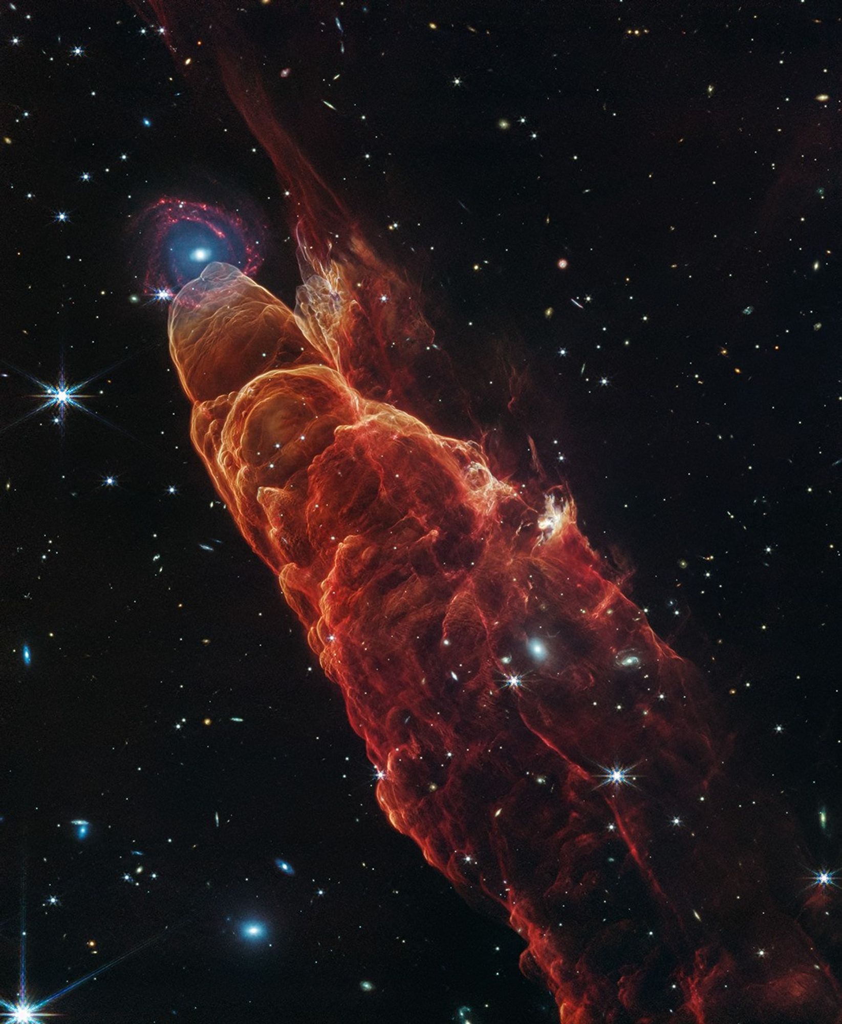
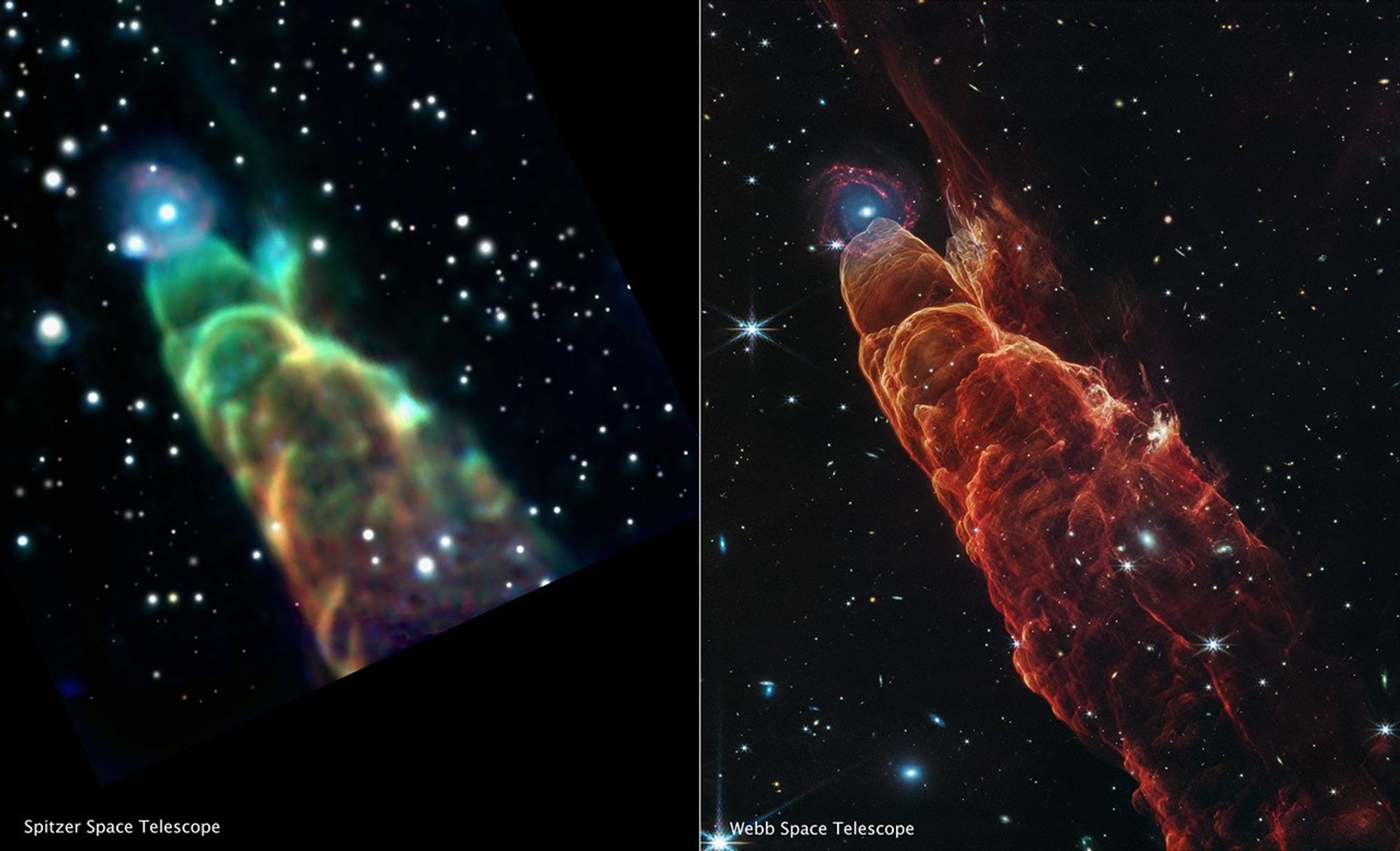
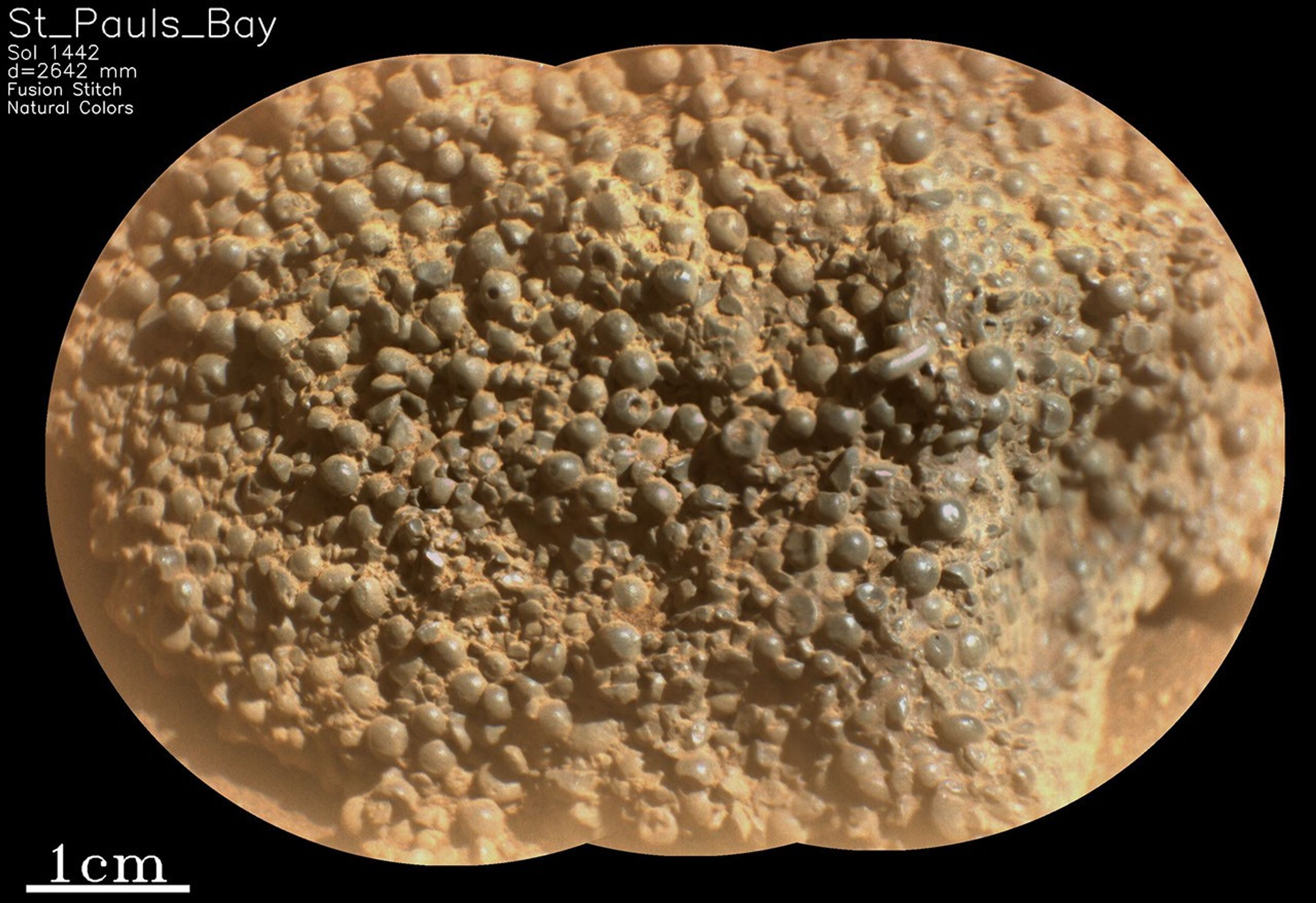
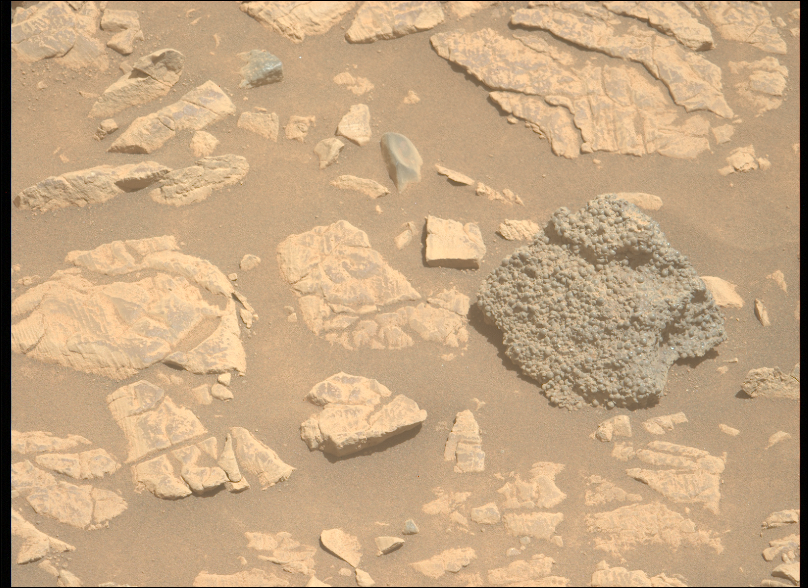
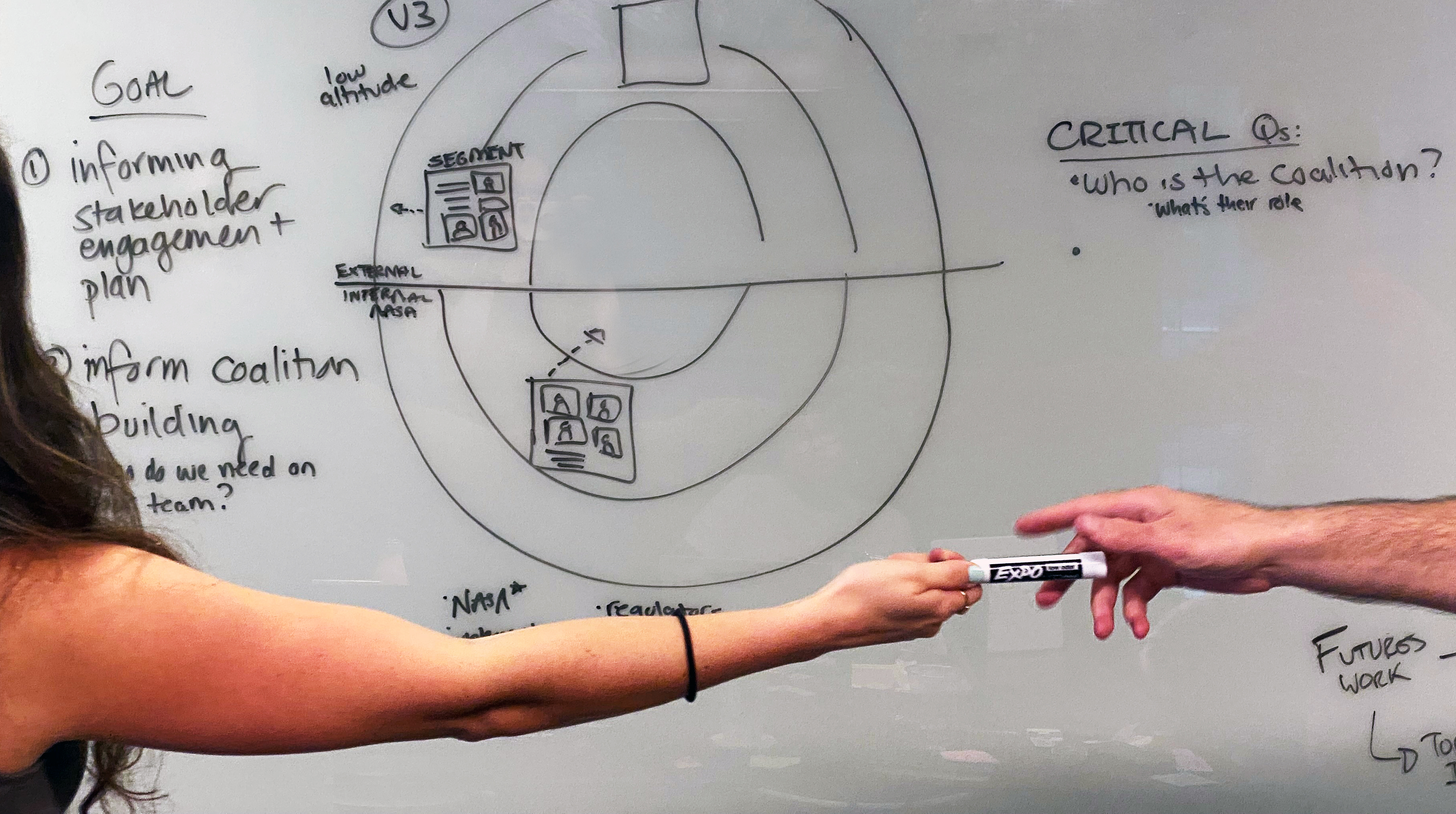
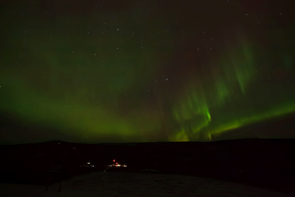
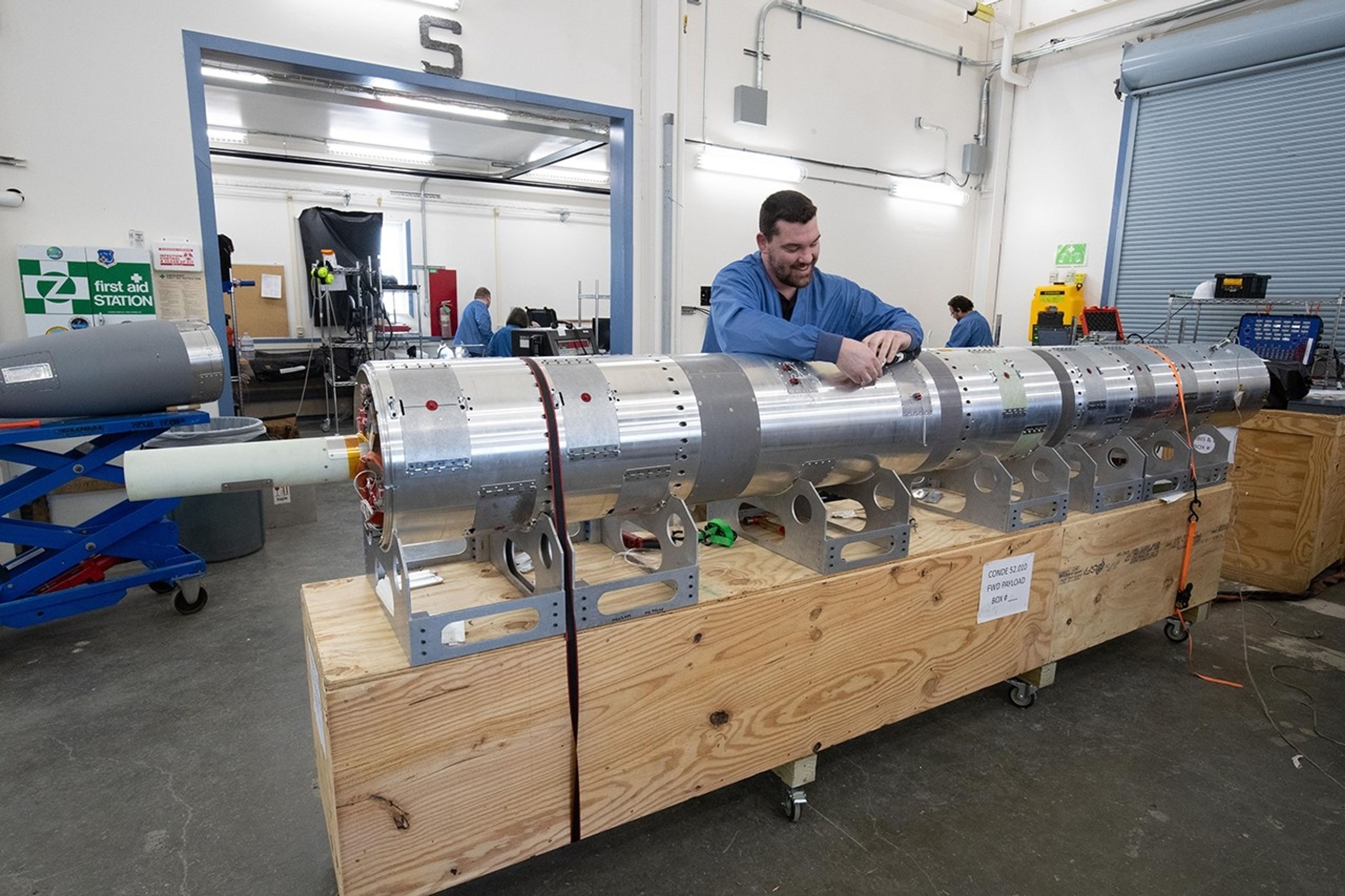
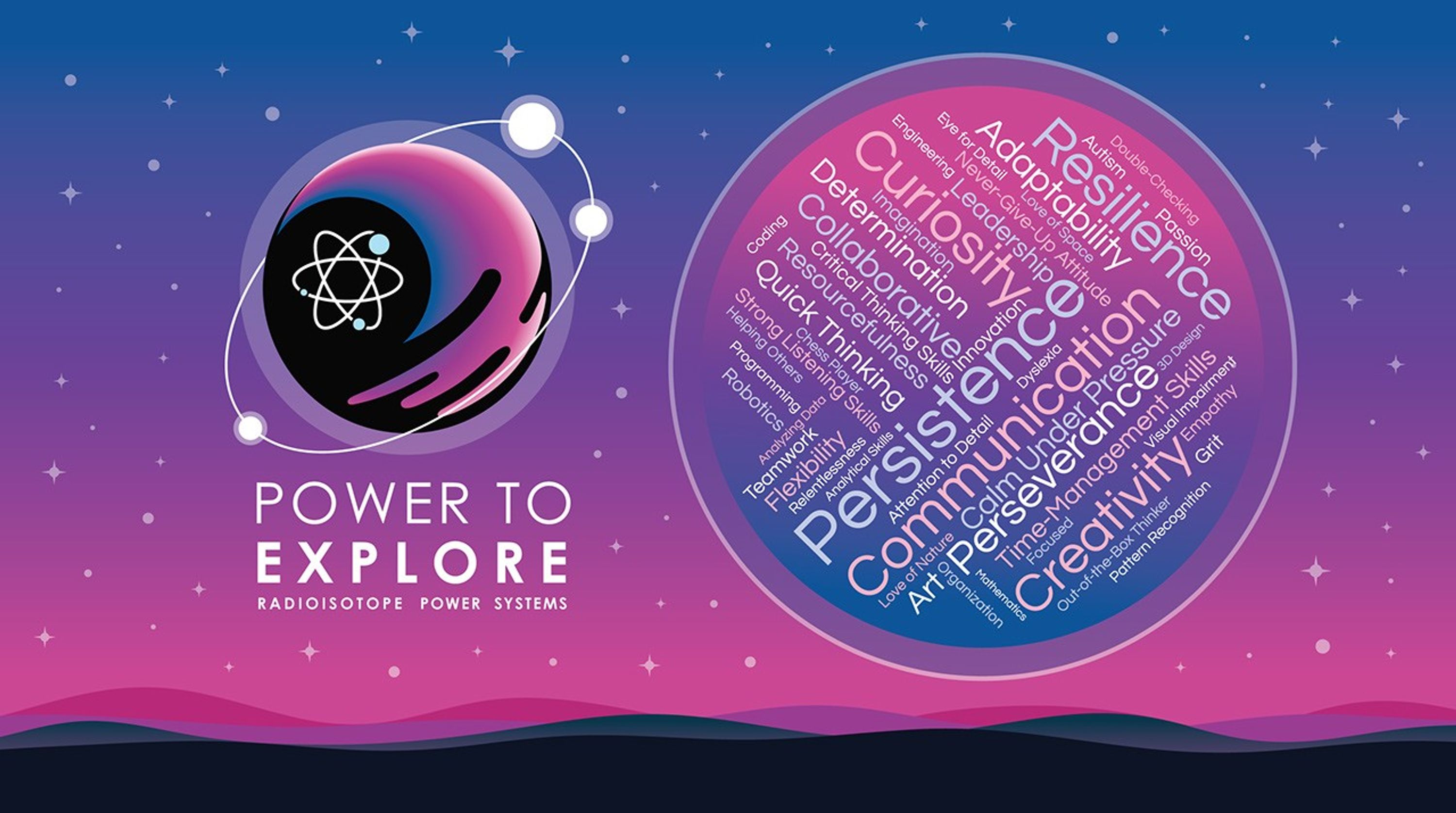
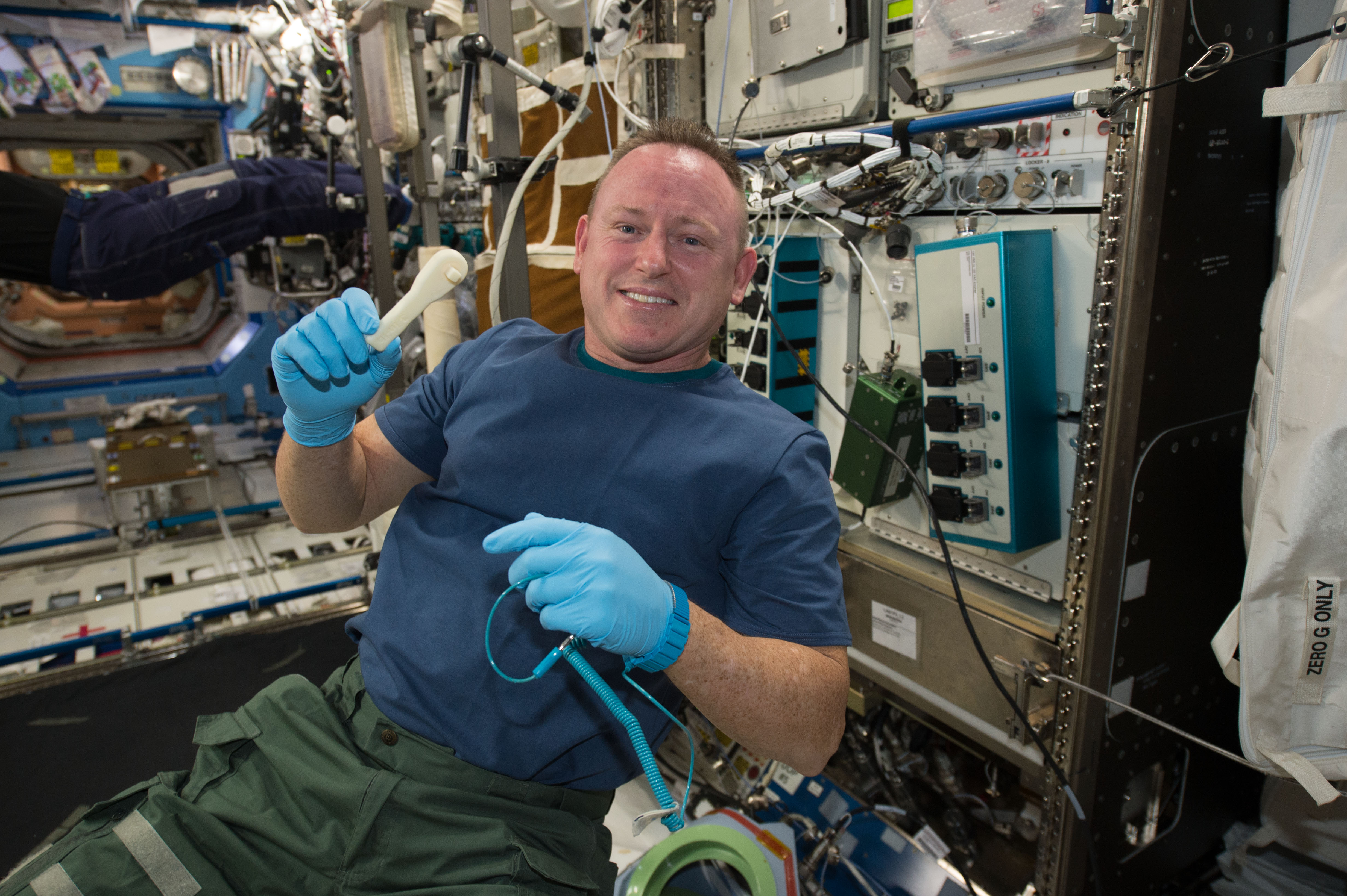
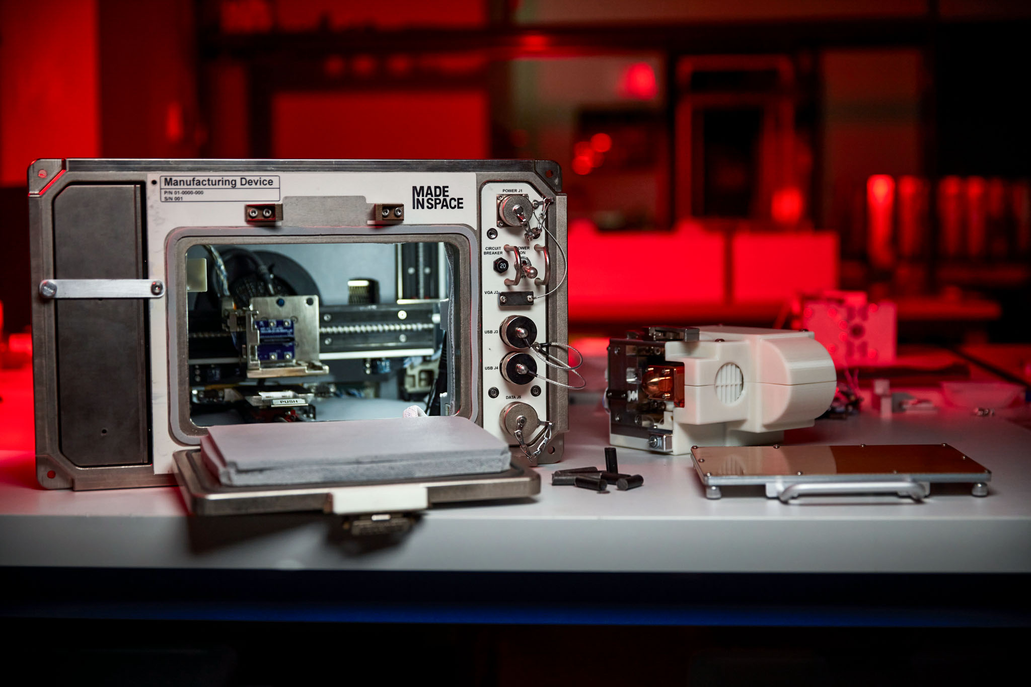
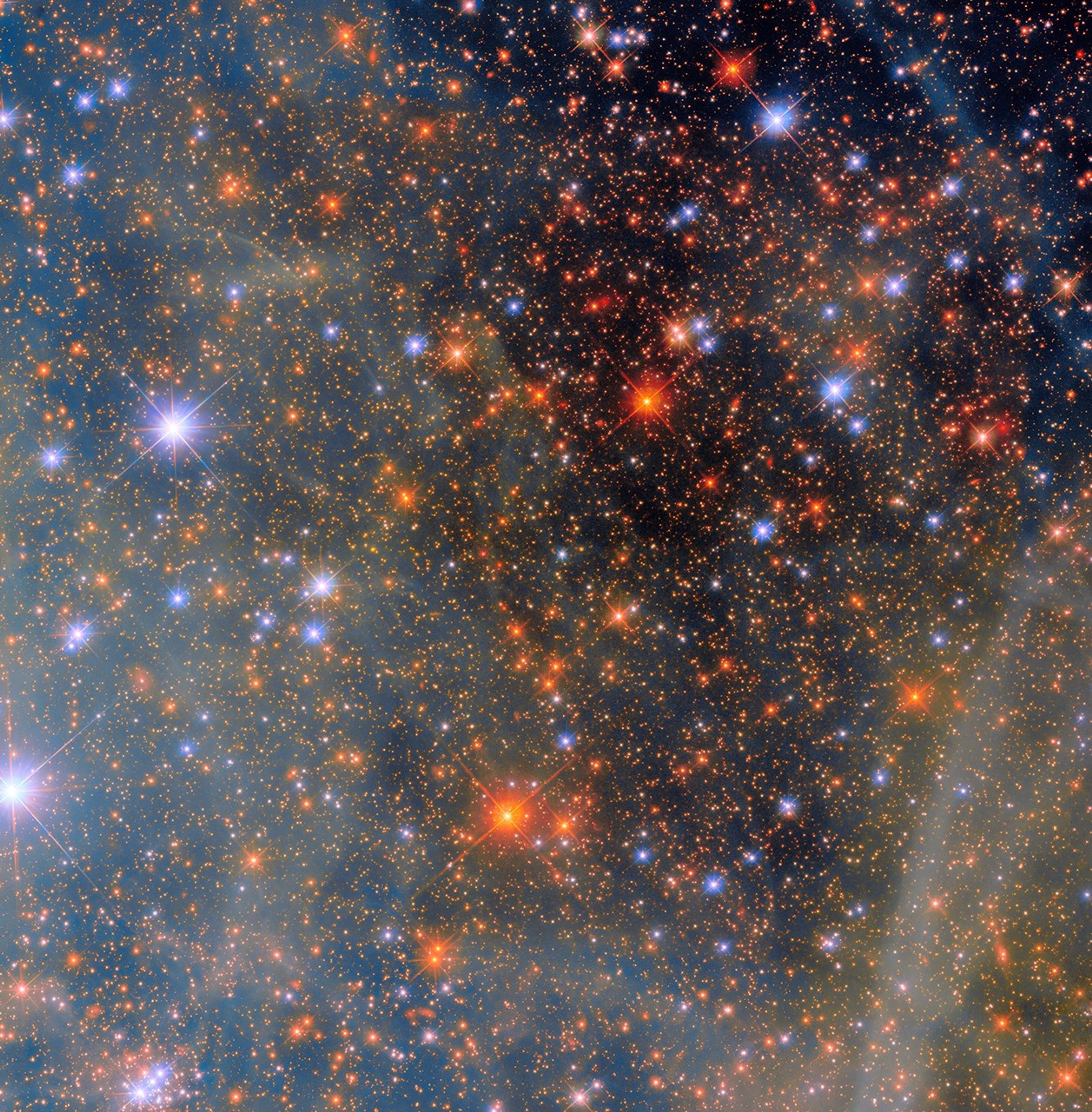
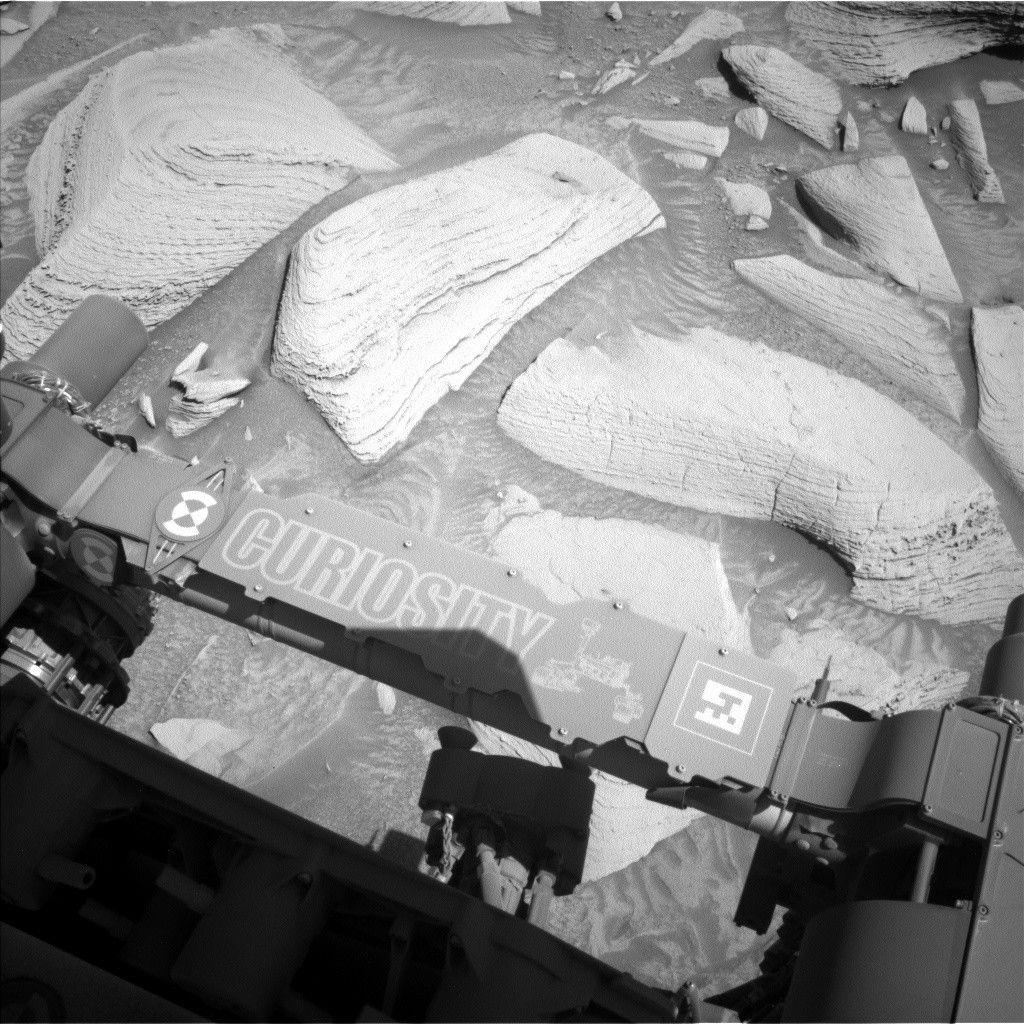
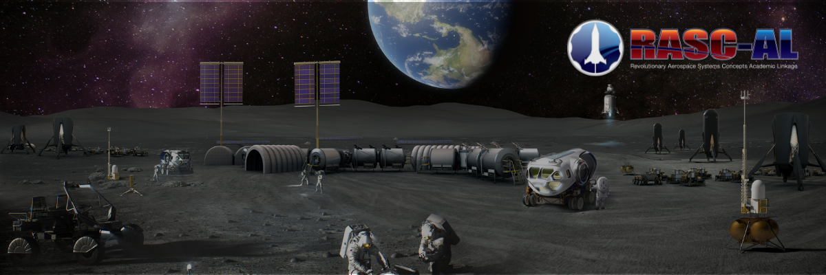
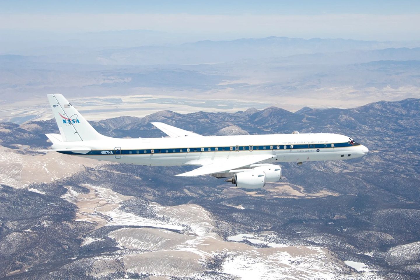
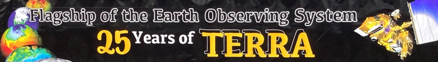
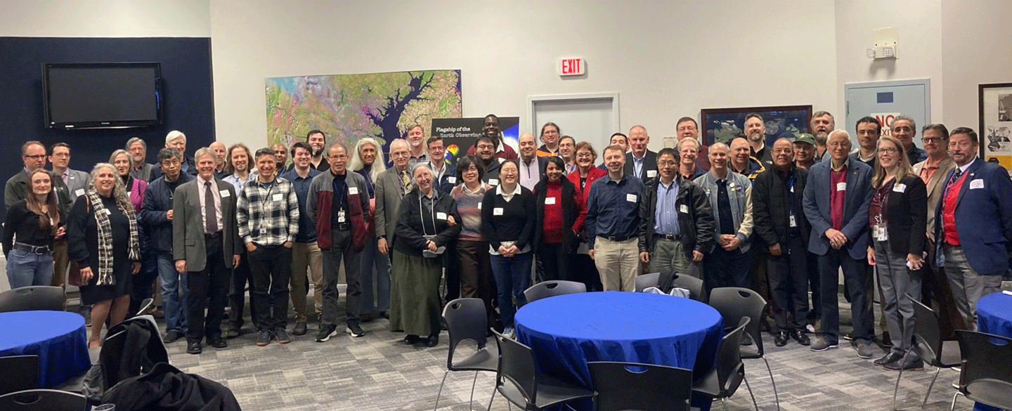