
NASA
Second Lady Usha Vance, NASA Astronaut Suni Williams Celebrate Reading
Second Lady Usha Vance and NASA Astronaut Suni Williams listen to the audience in this image from Aug. 4, 2025. Ms. Vance joined Williams at NASA’s Johnson Space Center in Houston for a summer reading challenge event, through which the Second Lady encourages youth to seek adventure, imagination, and discovery between the pages of a book.
Image credit: NASA
Second Lady Usha Vance, NASA Astronaut Suni Williams Celebrate Reading
Curiosity Blog, Sols 4616-4617: Standing Tall on the Ridge
- Curiosity Home
- Science
- News and Features
- Multimedia
- Mars Missions
- Mars Home
4 min read
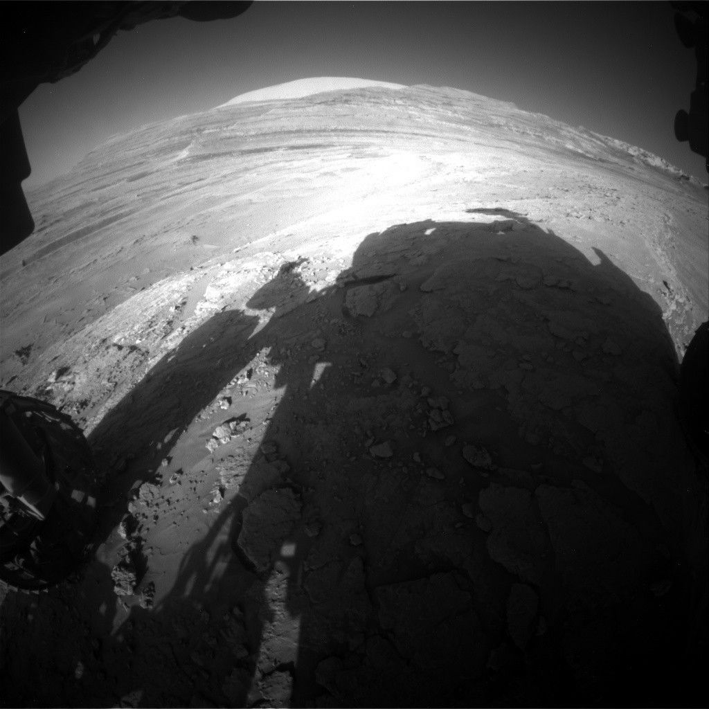
Curiosity Blog, Sols 4616-4617: Standing Tall on the Ridge NASA’s Mars rover Curiosity acquired this image, showing the impressive landscape it is currently navigating. The rover is standing tall on the ridge, its shadow casting forward, and Mount Sharp towers over the scene in the distance. Curiosity captured this image with its Front Hazard Avoidance Camera (Front Hazcam) on July 30, 2025 — Sol 4614, or Martian day 4,614 of the Mars Science Laboratory mission — at 02:24:02 UTC. NASA/JPL-CaltechWritten by Susanne P. Schwenzer, Professor of Planetary Mineralogy at The Open University, UK
Earth planning date: Wednesday, July 30, 2025
The day started with a little celebration of NISAR, a new Earth observation satellite that made it successfully into orbit a few hours before our planning started. We joined in by saying “GO NISAR, NASA, JPL, and ISRO” (the Indian Space Research Organisation, NASA’s mission partner, which launched NISAR). Learn more at the NISAR mission hub. Although our team studies Mars, Earth is a planet, too, and we are very happy for our colleagues’ successful launch!
On Mars, it’s still winter and the topic of every planning is how to maximize the science we can do given the increased power needs for heating our rover at this time of the year. Curiosity is parked on top of the main ridge, nicknamed the “autobahn.” It turned out to be not as smooth as its terrestrial namesake, as you can see in the image above. To arrive at this parking position, our rover drivers decided to take a small detour down into a flatter area and back up onto the ridge for safe off-road driving. The rover’s parking position allows for beautiful views around us, laying out the land of hollows and ridges perfectly to plan our next steps and to admire Mount Sharp in the distance.
Standing tall on the ridge, we got several investigations of the ridge-forming materials into today’s plan. APXS, MAHLI, and ChemCam are all teaming up to investigate the target “El Salto.” This is a target that could get us a glimpse into what formed the central line that is running along the big ridge. If you look closely at the images there are subtle differences in color and texture, and we are all curious whether that translates to chemical differences, too.
Of course, it’s not all about chemistry. Mastcam is busy documenting a small mound, and its context with veins and the hollow surrounding it, at the target “Llullaillaco.” The target “Cementerio De Tortugas” will capture sand ripples within a trough area, there is an extension of the workspace imaging in the plan for more context of today’s observations, and finally the ridge intersection is of interest at the target “Villa Abecia.” Of course, Mastcam didn’t forget the documentation of the ChemCam target “El Salto” and the AEGIS target from the last plan. Speaking of ChemCam: It’s using its imaging capabilities to document the side of the ridge to give finer details of the sedimentary structures of the target “Llullaillaco.”
Atmospheric observations are also of highest interest at this time of the day. We continue our atmospheric monitoring by looking for dust devils as well as up toward the clouds in a joint observation with the CASSIS instrument, which is aboard the European Space Agency’s Trace Gas Orbiter. In addition, Curiosity continues to monitor wind and temperature throughout the plan, and the DAN (dynamic albedo of neutrons) instrument observes the rocks underneath the rover for their water content.
After completing the observations at the current parking location, Curiosity will be driving off the ridge again, but this time to stay within the hollow, so we can make observations of the material that forms those hollows. Let’s see if we can find any chemical differences between those materials that might explain why one is standing up tall and the other one is weathering out. If you want to get a better impression of what I am talking about when I say ridges and troughs, have a look at this recent navigation camera mosaic.
Learn more about Curiosity’s science instruments
For more Curiosity blog posts, visit MSL Mission Updates
Share Details Last Updated Aug 04, 2025 Related Terms Explore More 2 min read Curiosity Blog, Sols 4614-4615: Driving Along the Boxwork
Article
6 days ago
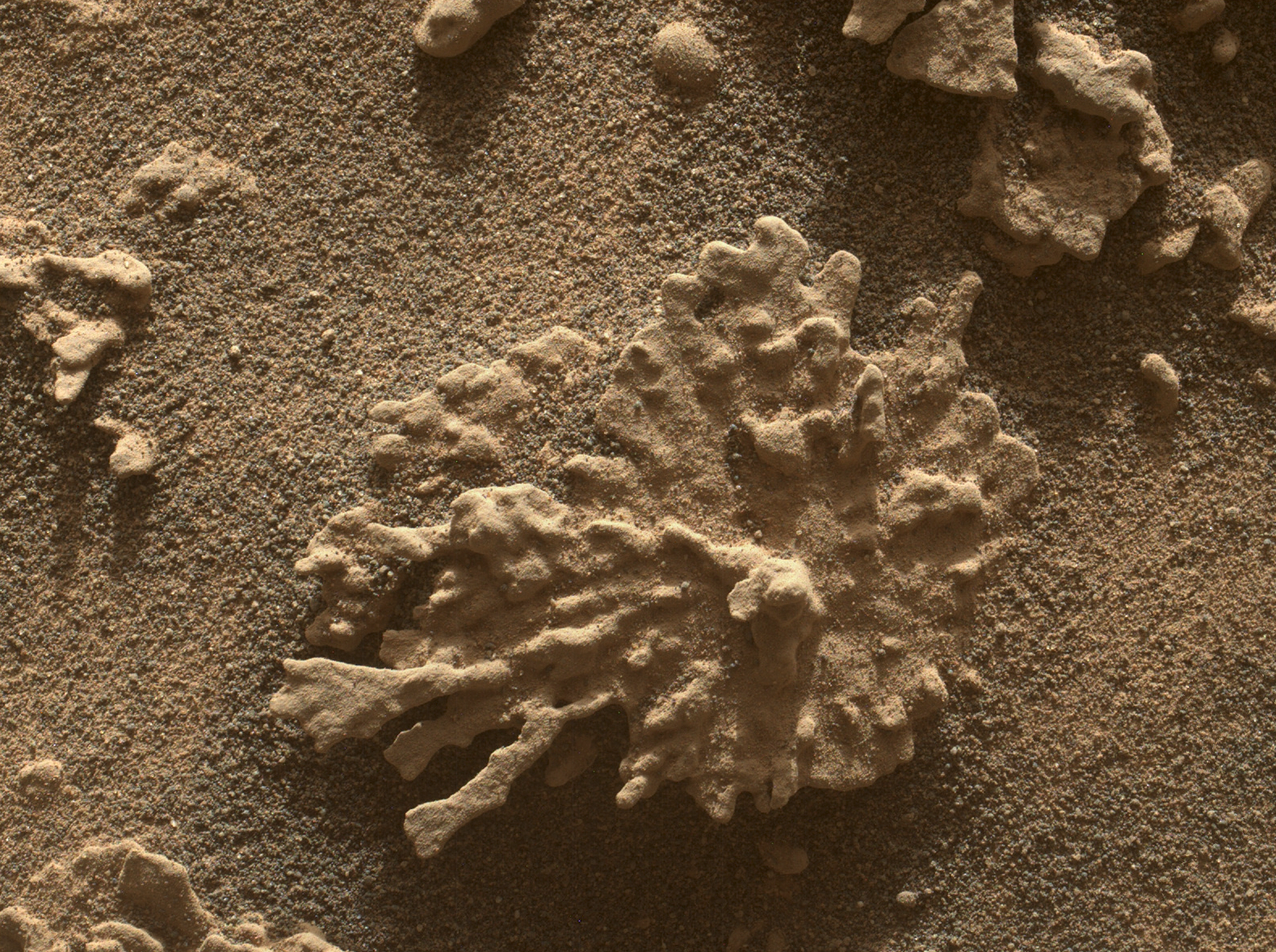
3 min read Spheres in the Sand
Article
6 days ago
2 min read Curiosity Blog, Sols 4611-4613: Scenic Overlook
Article
7 days ago
Keep Exploring Discover More Topics From NASA Mars
Mars is the fourth planet from the Sun, and the seventh largest. It’s the only planet we know of inhabited…
All Mars Resources
Explore this collection of Mars images, videos, resources, PDFs, and toolkits. Discover valuable content designed to inform, educate, and inspire,…
Rover Basics
Each robotic explorer sent to the Red Planet has its own unique capabilities driven by science. Many attributes of a…
Mars Exploration: Science Goals
The key to understanding the past, present or future potential for life on Mars can be found in NASA’s four…
Curiosity Blog, Sols 4616-4617: Standing Tall on the Ridge
- Curiosity Home
- Science
- News and Features
- Multimedia
- Mars Missions
- Mars Home
4 min read
Curiosity Blog, Sols 4616-4617: Standing Tall on the Ridge NASA’s Mars rover Curiosity acquired this image, showing the impressive landscape it is currently navigating. The rover is standing tall on the ridge, its shadow casting forward, and Mount Sharp towers over the scene in the distance. Curiosity captured this image with its Front Hazard Avoidance Camera (Front Hazcam) on July 30, 2025 — Sol 4614, or Martian day 4,614 of the Mars Science Laboratory mission — at 02:24:02 UTC.NASA/JPL-CaltechWritten by Susanne P. Schwenzer, Professor of Planetary Mineralogy at The Open University, UK
Earth planning date: Wednesday, July 30, 2025
The day started with a little celebration of NISAR, a new Earth observation satellite that made it successfully into orbit a few hours before our planning started. We joined in by saying “GO NISAR, NASA, JPL, and ISRO” (the Indian Space Research Organisation, NASA’s mission partner, which launched NISAR). Learn more at the NISAR mission hub. Although our team studies Mars, Earth is a planet, too, and we are very happy for our colleagues’ successful launch!
On Mars, it’s still winter and the topic of every planning is how to maximize the science we can do given the increased power needs for heating our rover at this time of the year. Curiosity is parked on top of the main ridge, nicknamed the “autobahn.” It turned out to be not as smooth as its terrestrial namesake, as you can see in the image above. To arrive at this parking position, our rover drivers decided to take a small detour down into a flatter area and back up onto the ridge for safe off-road driving. The rover’s parking position allows for beautiful views around us, laying out the land of hollows and ridges perfectly to plan our next steps and to admire Mount Sharp in the distance.
Standing tall on the ridge, we got several investigations of the ridge-forming materials into today’s plan. APXS, MAHLI, and ChemCam are all teaming up to investigate the target “El Salto.” This is a target that could get us a glimpse into what formed the central line that is running along the big ridge. If you look closely at the images there are subtle differences in color and texture, and we are all curious whether that translates to chemical differences, too.
Of course, it’s not all about chemistry. Mastcam is busy documenting a small mound, and its context with veins and the hollow surrounding it, at the target “Llullaillaco.” The target “Cementerio De Tortugas” will capture sand ripples within a trough area, there is an extension of the workspace imaging in the plan for more context of today’s observations, and finally the ridge intersection is of interest at the target “Villa Abecia.” Of course, Mastcam didn’t forget the documentation of the ChemCam target “El Salto” and the AEGIS target from the last plan. Speaking of ChemCam: It’s using its imaging capabilities to document the side of the ridge to give finer details of the sedimentary structures of the target “Llullaillaco.”
Atmospheric observations are also of highest interest at this time of the day. We continue our atmospheric monitoring by looking for dust devils as well as up toward the clouds in a joint observation with the CASSIS instrument, which is aboard the European Space Agency’s Trace Gas Orbiter. In addition, Curiosity continues to monitor wind and temperature throughout the plan, and the DAN (dynamic albedo of neutrons) instrument observes the rocks underneath the rover for their water content.
After completing the observations at the current parking location, Curiosity will be driving off the ridge again, but this time to stay within the hollow, so we can make observations of the material that forms those hollows. Let’s see if we can find any chemical differences between those materials that might explain why one is standing up tall and the other one is weathering out. If you want to get a better impression of what I am talking about when I say ridges and troughs, have a look at this recent navigation camera mosaic.
Learn more about Curiosity’s science instruments For more Curiosity blog posts, visit MSL Mission Updates Share Details Last Updated Aug 04, 2025 Related Terms Explore More 2 min read Curiosity Blog, Sols 4614-4615: Driving Along the Boxwork Article 6 days ago 3 min read Spheres in the Sand Article 6 days ago 2 min read Curiosity Blog, Sols 4611-4613: Scenic Overlook Article 7 days ago Keep Exploring Discover More Topics From NASA MarsMars is the fourth planet from the Sun, and the seventh largest. It’s the only planet we know of inhabited…
All Mars ResourcesExplore this collection of Mars images, videos, resources, PDFs, and toolkits. Discover valuable content designed to inform, educate, and inspire,…
Rover BasicsEach robotic explorer sent to the Red Planet has its own unique capabilities driven by science. Many attributes of a…
Mars Exploration: Science GoalsThe key to understanding the past, present or future potential for life on Mars can be found in NASA’s four…
NASA’s Black Marble: Stories from the Night Sky
1 min read
NASA’s Black Marble: Stories from the Night Sky Earth (ESD)- Earth
- Explore
- Science at Work
- Multimedia
- Data
- For Researchers
- About Us
Viewed from space, Earth at night tells endless stories. Using satellite data, we can track population growth, natural disaster damage, cultural celebrations, and even space weather. Studying these glowing patterns helps us understand human activity, respond to disasters, and witness a changing world.
Original Video and Assets
Share Details Last Updated Aug 04, 2025 Related Terms Explore More 4 min read NUBE: New Card Game Helps Learners Identify Cloud Types Through Play
Article
3 days ago
6 min read NASA’s TRACERS Studies Explosive Process in Earth’s Magnetic Shield
Article
3 weeks ago
2 min read Polar Tourists Give Positive Reviews to NASA Citizen Science in Antarctica
Article
4 weeks ago
Keep Exploring Discover More Topics From NASA Earth
Your home. Our Mission. And the one planet that NASA studies more than any other.
Explore Earth Science
Earth Science in Action
NASA’s unique vantage point helps us inform solutions to enhance decision-making, improve livelihoods, and protect our planet.
Earth Multimedia & Galleries
NASA’s Black Marble: Stories from the Night Sky
1 min read
NASA’s Black Marble: Stories from the Night Sky Earth (ESD)- Earth
- Explore
- Science at Work
- Multimedia
- Data
- For Researchers
- About Us
Viewed from space, Earth at night tells endless stories. Using satellite data, we can track population growth, natural disaster damage, cultural celebrations, and even space weather. Studying these glowing patterns helps us understand human activity, respond to disasters, and witness a changing world.
Original Video and Assets Share Details Last Updated Aug 04, 2025 Related Terms Explore More 4 min read NUBE: New Card Game Helps Learners Identify Cloud Types Through Play Article 3 days ago 6 min read NASA’s TRACERS Studies Explosive Process in Earth’s Magnetic Shield Article 3 weeks ago 2 min read Polar Tourists Give Positive Reviews to NASA Citizen Science in Antarctica Article 4 weeks ago Keep Exploring Discover More Topics From NASA EarthYour home. Our Mission. And the one planet that NASA studies more than any other.
Explore Earth Science
Earth Science in ActionNASA’s unique vantage point helps us inform solutions to enhance decision-making, improve livelihoods, and protect our planet.
Earth Multimedia & Galleries
STEM Educators Are Bringing Hands-On NASA Science into Virginia Classrooms
4 min read
STEM Educators Are Bringing Hands-On NASA Science into Virginia ClassroomsProfessional learning experiences are integral to the enhancement of classroom instruction. Teachers, at the forefront of Science, Technology, Engineering, & Mathematics (STEM) education, play a key role in the advancement of STEM learning ecosystems and citizen science.
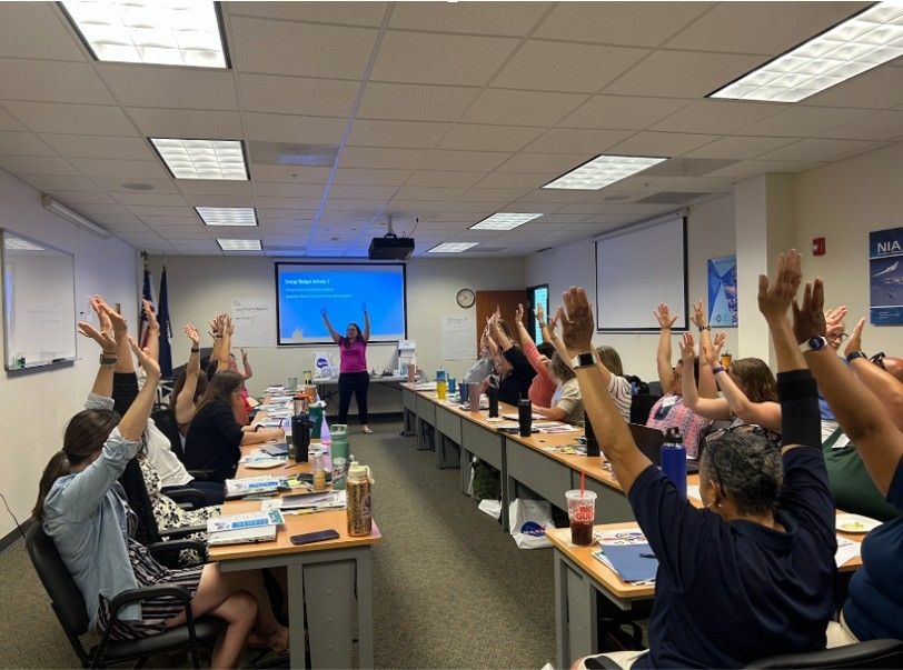
On June 24-25, 2025 – despite a major east coast heat wave – twenty-four educators from eight school districts in the Hampton Roads region of southeastern Virginia (Newport News, Hampton City, Virginia Beach City, Isle of Wight County, Poquoson City, Norfolk, York County, and Suffolk Public Schools) converged at the National Institute of Aerospace (NIA) in Hampton, VA for a professional development workshop led by experts from NASA Langley Research Center and the NASA Science Activation program’s NIA-led NASA eClips team. Developed in collaboration with another NASA Science Activation team, GLOBE (Global Learning and Observations to Benefit the Environment) Mission Earth, and with support from the Coastal Virginia STEM Hub (COVA STEM) – a “STEM learning ecosystem targeting pre-K to adult residents in Coastal Virginia” – this two-day training, also provided comprehensive resources, including lesson plans, pacing guides, classroom activities, and books, all designed for integration into Hampton Roads classrooms.
The NASA Langley team led workshop participants through a training about GLOBE, a program dedicated to advancing Earth System science through data collected by volunteer members of the public, also known as ‘citizen scientists’. GLOBE invites educators, students, and members of the public worldwide (regardless of citizenship) to collect and submit cloud, surface temperature, and land cover observations using the GLOBE Observer app – a real-time data collection tool available right on their smartphones. These observations are then used to help address scientific questions at local, regional, and global scales. Through this training, the educators participated in K-20 classroom-friendly sample lessons, hands-on activities, and exploring the GLOBE Observer app, ultimately qualifying them as GLOBE Certified Educators. Earth System science lessons, activities, and information on how to download the GLOBE Observer citizen science app are available on the GLOBE website. Similarly, NASA eClips, which focuses on increasing STEM literacy in K-12 students, provided educators with free, valuable, standards-based classroom resources such as educator guides, informational videos, engineering design packets, and hands-on activities, which are available to educators and students alike on the NASA eClips’ website. Throughout the training, educators collaborated in grade-level groups, brainstorming new ways to integrate these standards-based NASA science resources.
One educator envisioned incorporating GLOBE’s cloud resources and supportive NASA eClips videos into her energy budget unit. Others explored modifying a heat-lamp experiment to include humidity and heat capacity. One teacher enthusiastically noted in response to a GLOBE urban heat island lesson plan, “The hands-on elements are going to be really great deliverables!” The creative energy and passion for education were palpable.
The dedication of both NIA and NASA Langley to education and local community support was evident. This professional learning experience offered educators immediately-applicable classroom activities and fostered connections among NASA science, NASA eClips, the GLOBE Program, and fellow educators across district lines. One educator highlighted the value of these networking opportunities, stating, “I do love that we’re able to collaborate with our colleagues so we can plan for our future units during the school year”. Another participant commented, “This is a great program…I am going to start embedding [this] in our curriculum.”
GME (supported by NASA under cooperative agreement award number NNX16AC54A) and NASA eClips (supported by NASA under cooperative agreement award number NNX16AB91A) are part of NASA’s Science Activation Portfolio. Learn more about how Science Activation connects NASA science experts, real content, and experiences with community leaders to do science in ways that activate minds and promote deeper understanding of our world and beyond: https://science.nasa.gov/learn
GLOBE educator Marilé Colón Robles demonstrates a kinesthetic activity. Share Details Last Updated Aug 04, 2025 Editor NASA Science Editorial Team Location NASA Langley Research Center Related Terms Explore More 4 min read NUBE: New Card Game Helps Learners Identify Cloud Types Through PlayArticle
3 days ago
3 min read NASA eClips STEM Student Ambassadors Light Up CNU’s 2025 STEM Community Day
Article
2 weeks ago
2 min read GLOBE-Trotting Science Lands in Chesapeake with NASA eClips
Article
2 weeks ago
Keep Exploring Discover More Topics From NASA James Webb Space Telescope
Webb is the premier observatory of the next decade, serving thousands of astronomers worldwide. It studies every phase in the…
Perseverance Rover
This rover and its aerial sidekick were assigned to study the geology of Mars and seek signs of ancient microbial…
Parker Solar Probe
On a mission to “touch the Sun,” NASA’s Parker Solar Probe became the first spacecraft to fly through the corona…
Juno
NASA’s Juno spacecraft entered orbit around Jupiter in 2016, the first explorer to peer below the planet’s dense clouds to…
STEM Educators Are Bringing Hands-On NASA Science into Virginia Classrooms
4 min read
STEM Educators Are Bringing Hands-On NASA Science into Virginia ClassroomsProfessional learning experiences are integral to the enhancement of classroom instruction. Teachers, at the forefront of Science, Technology, Engineering, & Mathematics (STEM) education, play a key role in the advancement of STEM learning ecosystems and citizen science.
On June 24-25, 2025 – despite a major east coast heat wave – twenty-four educators from eight school districts in the Hampton Roads region of southeastern Virginia (Newport News, Hampton City, Virginia Beach City, Isle of Wight County, Poquoson City, Norfolk, York County, and Suffolk Public Schools) converged at the National Institute of Aerospace (NIA) in Hampton, VA for a professional development workshop led by experts from NASA Langley Research Center and the NASA Science Activation program’s NIA-led NASA eClips team. Developed in collaboration with another NASA Science Activation team, GLOBE (Global Learning and Observations to Benefit the Environment) Mission Earth, and with support from the Coastal Virginia STEM Hub (COVA STEM) – a “STEM learning ecosystem targeting pre-K to adult residents in Coastal Virginia” – this two-day training, also provided comprehensive resources, including lesson plans, pacing guides, classroom activities, and books, all designed for integration into Hampton Roads classrooms.
The NASA Langley team led workshop participants through a training about GLOBE, a program dedicated to advancing Earth System science through data collected by volunteer members of the public, also known as ‘citizen scientists’. GLOBE invites educators, students, and members of the public worldwide (regardless of citizenship) to collect and submit cloud, surface temperature, and land cover observations using the GLOBE Observer app – a real-time data collection tool available right on their smartphones. These observations are then used to help address scientific questions at local, regional, and global scales. Through this training, the educators participated in K-20 classroom-friendly sample lessons, hands-on activities, and exploring the GLOBE Observer app, ultimately qualifying them as GLOBE Certified Educators. Earth System science lessons, activities, and information on how to download the GLOBE Observer citizen science app are available on the GLOBE website. Similarly, NASA eClips, which focuses on increasing STEM literacy in K-12 students, provided educators with free, valuable, standards-based classroom resources such as educator guides, informational videos, engineering design packets, and hands-on activities, which are available to educators and students alike on the NASA eClips’ website. Throughout the training, educators collaborated in grade-level groups, brainstorming new ways to integrate these standards-based NASA science resources.
One educator envisioned incorporating GLOBE’s cloud resources and supportive NASA eClips videos into her energy budget unit. Others explored modifying a heat-lamp experiment to include humidity and heat capacity. One teacher enthusiastically noted in response to a GLOBE urban heat island lesson plan, “The hands-on elements are going to be really great deliverables!” The creative energy and passion for education were palpable.
The dedication of both NIA and NASA Langley to education and local community support was evident. This professional learning experience offered educators immediately-applicable classroom activities and fostered connections among NASA science, NASA eClips, the GLOBE Program, and fellow educators across district lines. One educator highlighted the value of these networking opportunities, stating, “I do love that we’re able to collaborate with our colleagues so we can plan for our future units during the school year”. Another participant commented, “This is a great program…I am going to start embedding [this] in our curriculum.”
GME (supported by NASA under cooperative agreement award number NNX16AC54A) and NASA eClips (supported by NASA under cooperative agreement award number NNX16AB91A) are part of NASA’s Science Activation Portfolio. Learn more about how Science Activation connects NASA science experts, real content, and experiences with community leaders to do science in ways that activate minds and promote deeper understanding of our world and beyond: https://science.nasa.gov/learn
GLOBE educator Marilé Colón Robles demonstrates a kinesthetic activity. Share Details Last Updated Aug 04, 2025 EditorNASA Science Editorial TeamLocationNASA Langley Research Center Related Terms Explore More 4 min read NUBE: New Card Game Helps Learners Identify Cloud Types Through Play Article 3 days ago 3 min read NASA eClips STEM Student Ambassadors Light Up CNU’s 2025 STEM Community Day Article 2 weeks ago 2 min read GLOBE-Trotting Science Lands in Chesapeake with NASA eClips Article 2 weeks ago Keep Exploring Discover More Topics From NASA James Webb Space TelescopeWebb is the premier observatory of the next decade, serving thousands of astronomers worldwide. It studies every phase in the…
Perseverance RoverThis rover and its aerial sidekick were assigned to study the geology of Mars and seek signs of ancient microbial…
Parker Solar ProbeOn a mission to “touch the Sun,” NASA’s Parker Solar Probe became the first spacecraft to fly through the corona…
JunoNASA’s Juno spacecraft entered orbit around Jupiter in 2016, the first explorer to peer below the planet’s dense clouds to…
NASA’s Lunar Trailblazer Moon Mission Ends
The small satellite was to map lunar water, but operators lost contact with the spacecraft the day after launch and were unable to recover the mission.
NASA’s Lunar Trailblazer ended its mission to the Moon on July 31. Despite extensive efforts, mission operators were unable to establish two-way communications after losing contact with the spacecraft the day following its Feb. 26 launch.
The mission aimed to produce high-resolution maps of water on the Moon’s surface and determine what form the water is in, how much is there, and how it changes over time. The maps would have supported future robotic and human exploration of the Moon as well as commercial interests while also contributing to the understanding of water cycles on airless bodies throughout the solar system.
Lunar Trailblazer shared a ride on the second Intuitive Machines robotic lunar lander mission, IM-2, which lifted off at 7:16 p.m. EST on Feb. 26 aboard a SpaceX Falcon 9 rocket from the agency’s Kennedy Space Center in Florida. The small satellite separated as planned from the rocket about 48 minutes after launch to begin its flight to the Moon. Mission operators at Caltech’s IPAC in Pasadena established communications with the small spacecraft at 8:13 p.m. EST. Contact was lost the next day.
Without two-way communications, the team was unable to fully diagnose the spacecraft or perform the thruster operations needed to keep Lunar Trailblazer on its flight path.
“At NASA, we undertake high-risk, high-reward missions like Lunar Trailblazer to find revolutionary ways of doing new science,” said Nicky Fox, associate administrator, Science Mission Directorate at NASA Headquarters in Washington. “While it was not the outcome we had hoped for, mission experiences like Lunar Trailblazer help us to learn and reduce the risk for future, low-cost small satellites to do innovative science as we prepare for a sustained human presence on the Moon. Thank you to the Lunar Trailblazer team for their dedication in working on and learning from this mission through to the end.”
The limited data the mission team had received from Lunar Trailblazer indicated that the spacecraft’s solar arrays were not properly oriented toward the Sun, which caused its batteries to become depleted.
For several months, collaborating organizations around the world — many of which volunteered their assistance — listened for the spacecraft’s radio signal and tracked its position. Ground radar and optical observations indicated that Lunar Trailblazer was in a slow spin as it headed farther into deep space.
“As Lunar Trailblazer drifted far beyond the Moon, our models showed that the solar panels might receive more sunlight, perhaps charging the spacecraft’s batteries to a point it could turn on its radio,” said Andrew Klesh, Lunar Trailblazer’s project systems engineer at NASA’s Jet Propulsion Laboratory in Southern California. “The global community’s support helped us better understand the spacecraft’s spin, pointing, and trajectory. In space exploration, collaboration is critical — this gave us the best chance to try to regain contact.”
However, as time passed, Lunar Trailblazer became too distant to recover as its telecommunications signals would have been too weak for the mission to receive telemetry and to command.
Technological LegacyThe small satellite’s High-resolution Volatiles and Minerals Moon Mapper (HVM3) imaging spectrometer was built by JPL to detect and map the locations of water and minerals. The mission’s Lunar Thermal Mapper (LTM) instrument was built by the University of Oxford in the United Kingdom and funded by the UK Space Agency to gather temperature data and determine the composition of silicate rocks and soils to improve understanding of why water content varies over time.
“We’re immensely disappointed that our spacecraft didn’t get to the Moon, but the two science instruments we developed, like the teams we brought together, are world class,” said Bethany Ehlmann, the mission’s principal investigator at Caltech. “This collective knowledge and the technology developed will cross-pollinate to other projects as the planetary science community continues work to better understand the Moon’s water.”
Some of that technology will live on in the JPL-built Ultra Compact Imaging Spectrometer for the Moon (UCIS-Moon) instrument that NASA recently selected for a future orbital flight opportunity. The instrument, which has has an identical spectrometer design as HVM3, will provide the Moon’s highest spatial resolution data of surface lunar water and minerals.
More About Lunar TrailblazerLunar Trailblazer was selected by NASA’s SIMPLEx (Small Innovative Missions for Planetary Exploration) competition, which provides opportunities for low-cost science spacecraft to ride-share with selected primary missions. To maintain the lower overall cost, SIMPLEx missions have a higher risk posture and less-stringent requirements for oversight and management. This higher risk acceptance bolsters NASA’s portfolio of targeted science missions designed to test pioneering mission approaches.
Caltech, which manages JPL for NASA, led Lunar Trailblazer’s science investigation, and Caltech’s IPAC led mission operations, which included planning, scheduling, and sequencing of all spacecraft activities. Along with managing Lunar Trailblazer, NASA JPL provided system engineering, mission assurance, the HVM3 instrument, and mission design and navigation. Lockheed Martin Space provided the spacecraft, integrated the flight system, and supported operations under contract with Caltech. The University of Oxford developed and provided the LTM instrument, funded by the UK Space Agency. Lunar Trailblazer, a project of NASA’s Lunar Discovery and Exploration Program, was managed by NASA’s Planetary Missions Program Office at Marshall Space Flight Center in Huntsville, Alabama, for the agency’s Science Mission Directorate in Washington.
News Media ContactsKaren Fox / Molly Wasser
NASA Headquarters, Washington
202-358-1600
karen.c.fox@nasa.gov / molly.l.wasser@nasa.gov
Ian J. O’Neill
Jet Propulsion Laboratory, Pasadena, Calif.
818-354-2649
ian.j.oneill@jpl.nasa.gov
Isabel Swafford
Caltech IPAC
626-216-4257
iswafford@ipac.caltech.edu
2025-099
Explore More 5 min read NASA’s Europa Clipper Radar Instrument Proves Itself at Mars Article 4 days ago 6 min read How Joint NASA-ESA Sea Level Mission Will Help Hurricane Forecasts Article 4 days ago 5 min read How NASA Is Testing AI to Make Earth-Observing Satellites Smarter Article 2 weeks ago Keep Exploring Discover More Topics From NASAMissions
Humans in Space
Climate Change
Solar System
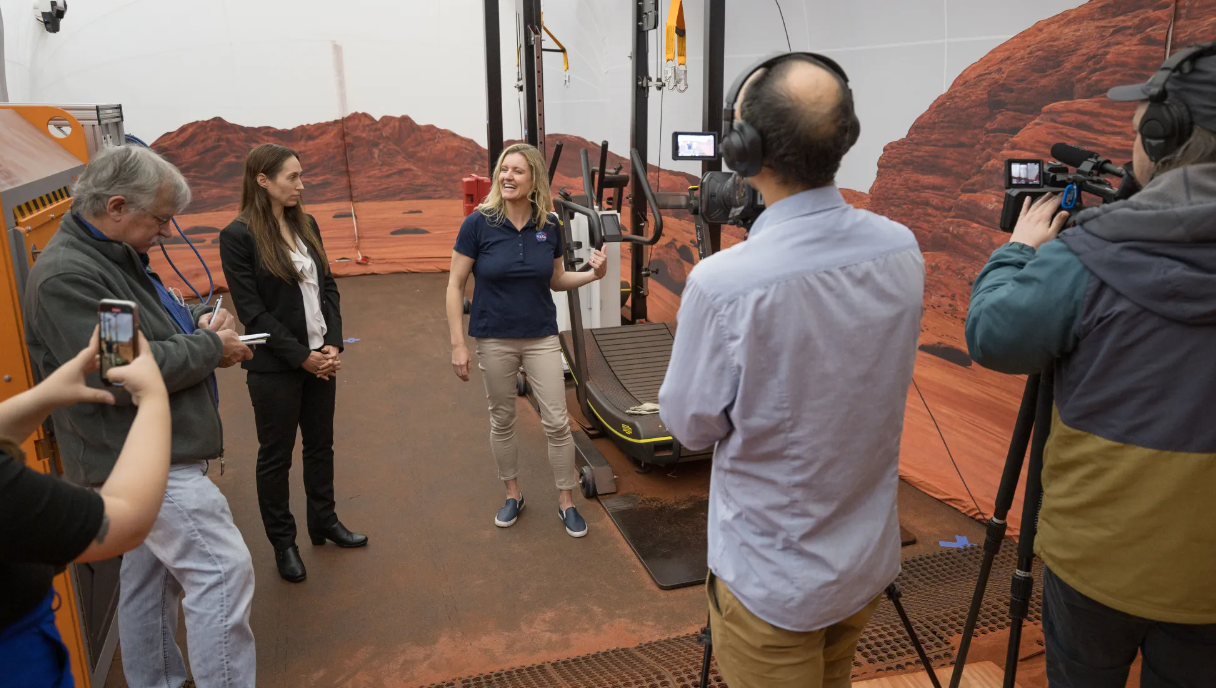
NASA Opens Simulated Mars Habitat to Media Ahead of Second Mission
As NASA prepares for its second year-long Mars simulated mission, media are invited to visit the ground-based habitat where the mission will take place, on Friday, Aug. 22, at the agency’s Johnson Space Center in Houston.
Scheduled to begin in October, four volunteer crew members will enter the agency’s Crew Health and Performance Exploration Analog (CHAPEA) 3D-printed habitat to live and work for a year to inform NASA’s preparations for human Mars missions.
The in-person media event includes an opportunity to speak with subject matter experts, and capture b-roll and photos inside the habitat. Crew members will not be available for interviews as they will arrive at NASA Johnson at a later date.
International media wishing to attend must request accreditation no later than 6 p.m. EDT (5 p.m. CDT), on Monday, Aug. 11. United States-based media have a deadline of 6 p.m. EDT (5 p.m. CDT), on Wednesday, Aug. 20, to register.
To request accreditation, media must contact the NASA Johnson newsroom at: 281-483-5111 or jsccommu@mail.nasa.gov. Space is limited. A copy of NASA’s media accreditation policy is available online.
Once the crew members kick off their mission, they will carry out various activities, including simulated Mars walks, robotic operations, habitat maintenance, medical technology tests, exercise, and crop growth. The crew also will face environmental stresses such as resource limitations, isolation, communication delays, and equipment failure, and work through these scenarios with the resources available inside the habitat.
To learn more about CHAPEA, visit:
https://www.nasa.gov/humans-in-space/chapea
-end-
Lauren Low
Headquarters, Washington
202-358-1600
lauren.e.low@nasa.gov
Kelsey Spivey / Mohi Kumar
Johnson Space Center, Houston
281-483-5111
kelsey.m.spivey@nasa.gov / mohi.kumar@nasa.gov
Marking 13 Years on Mars, NASA’s Curiosity Picks Up New Skills
5 min read
Preparations for Next Moonwalk Simulations Underway (and Underwater) This view of tracks trailing NASA’s Curiosity was captured July 26, 2025, as the rover simultaneously relayed data to a Mars orbiter. Combining tasks like this more efficiently uses energy generated by Curiosity’s nuclear power source, seen here lined with rows of white fins at the back of the rover.NASA/JPL-Caltech This is the same view of Curiosity’s July 25 mosaic, with labels indicating some key parts of the rover involved in recent efficiency improvements, plus a few prominent locations in the distance.NASA/JPL-CaltechNew capabilities allow the rover to do science with less energy from its batteries.
Thirteen years since Curiosity landed on Mars, engineers are finding ways to make the NASA rover even more productive. The six-wheeled robot has been given more autonomy and the ability to multitask — improvements designed to make the most of Curiosity’s energy source, a multi-mission radioisotope thermoelectric generator (MMRTG). Increased efficiency means the rover has ample power as it continues to decipher how the ancient Martian climate changed, transforming a world of lakes and rivers into the chilly desert it is today.
Explore the view Curiosity captured while multitaskingCuriosity recently rolled into a region filled with boxwork formations. These hardened ridges are believed to have been created by underground water billions of years ago. Stretching for miles on this part of Mount Sharp, a 3-mile-tall (5-kilometer-tall) mountain, the formations might reveal whether microbial life could have survived in the Martian subsurface eons ago, extending the period of habitability farther into when the planet was drying out.
NASA’s Curiosity viewed this rock shaped like a piece of coral on July 24, 2025, the 4,608th Martian day of the mission. The rover has found many rocks that — like this one — were formed by minerals deposited by ancient water flows combined with billions of years of sandblasting by wind.NASA/JPL-Caltech/MSSSCarrying out this detective work involves a lot of energy. Besides driving and extending a robotic arm to study rocks and cliffsides, Curiosity has a radio, cameras, and 10 science instruments that all need power. So do the multiple heaters that keep electronics, mechanical parts, and instruments operating at their best. Past missions like the Spirit and Opportunity rovers and the InSight lander relied on solar panels to recharge their batteries, but that technology always runs the risk of not receiving enough sunlight to provide power.
Instead, Curiosity and its younger sibling Perseverance each use their MMRTG nuclear power source, which relies on decaying plutonium pellets to create energy and recharge the rover’s batteries. Providing ample power for the rovers’ many science instruments, MMRTGs are known for their longevity (the twin Voyager spacecraft have relied on RTGs since 1977). But as the plutonium decays over time, it takes longer to recharge Curiosity’s batteries, leaving less energy for science each day.
The team carefully manages the rover’s daily power budget, factoring in every device that draws on the batteries. While these components were all tested extensively before launch, they are part of complex systems that reveal their quirks only after years in the extreme Martian environment. Dust, radiation, and sharp temperature swings bring out edge cases that engineers couldn’t have expected.
“We were more like cautious parents earlier in the mission,” said Reidar Larsen of NASA’s Jet Propulsion Laboratory in Southern California, which built and operates the rover. Larsen led a group of engineers who developed the new capabilities. “It’s as if our teenage rover is maturing, and we’re trusting it to take on more responsibility. As a kid, you might do one thing at a time, but as you become an adult, you learn to multitask.”
More Efficient ScienceGenerally, JPL engineers send Curiosity a list of tasks to complete one by one before the rover ends its day with a nap to recharge. In 2021, the team began studying whether two or three rover tasks could be safely combined, reducing the amount of time Curiosity is active.
For example, Curiosity’s radio regularly sends data and images to a passing orbiter, which relays them to Earth. Could the rover talk to an orbiter while driving, moving its robotic arm, or snapping images? Consolidating tasks could shorten each day’s plan, requiring less time with heaters on and instruments in a ready-to-use state, reducing the energy used. Testing showed Curiosity safely could, and all of these have now been successfully demonstrated on Mars.
Another trick involves letting Curiosity decide to nap if it finishes its tasks early. Engineers always pad their estimates for how long a day’s activity will take just in case hiccups arise. Now, if Curiosity completes those activities ahead of the time allotted, it will go to sleep early.
By letting the rover manage when it naps, there is less recharging to do before the next day’s plan. Even actions that trim just 10 or 20 minutes from a single activity add up over the long haul, maximizing the life of the MMRTG for more science and exploration down the road.
Miles to GoIn fact, the team has been implementing other new capabilities on Curiosity for years. Several mechanical issues required a rework of how the robotic arm’s rock-pulverizing drill collects samples, and driving capabilities have been enhanced with software updates. When a color filter wheel stopped turning on one of the two cameras mounted on Mastcam, Curiosity’s swiveling “head,” the team developed a workaround allowing them to capture the same beautiful panoramas.
JPL also developed an algorithm to reduce wear on Curiosity’s rock-battered wheels. And while engineers closely monitor any new damage, they aren’t worried: After 22 miles (35 kilometers) and extensive research, it’s clear that, despite some punctures, the wheels have years’ worth of travel in them. (And in a worst-case scenario, Curiosity could remove the damaged part of the wheel’s “tread” and still drive on the remaining part.)
Together, these measures are doing their job to keep Curiosity as busy as ever.
More About CuriosityCuriosity was built by NASA’s Jet Propulsion Laboratory, which is managed by Caltech in Pasadena, California. JPL leads the mission on behalf of NASA’s Science Mission Directorate in Washington as part of NASA’s Mars Exploration Program portfolio. Malin Space Science Systems in San Diego built and operates Mastcam.
For more about Curiosity, visit:
science.nasa.gov/mission/msl-curiosity
News Media ContactsAndrew Good
Jet Propulsion Laboratory, Pasadena, Calif.
818-393-2433
andrew.c.good@jpl.nasa.gov
Karen Fox / Molly Wasser
NASA Headquarters, Washington
202-358-1600
karen.c.fox@nasa.gov / molly.l.wasser@nasa.gov
2025-098
Share Details Last Updated Aug 04, 2025 Related Terms Explore More 4 min read NASA Tests New Heat Source Fuel for Deep Space Exploration Article 2 weeks ago 6 min read Advances in NASA Imaging Changed How World Sees Mars Article 4 weeks ago 6 min read NASA Mars Orbiter Learns New Moves After Nearly 20 Years in Space Article 1 month ago Keep Exploring Discover Related TopicsMissions
Humans in Space
Climate Change
Solar System
Perseids Meteor Shower
Perseids Meteor Shower
In this 30 second exposure photograph, a meteor streaks across the sky during the annual Perseid and Alpha Capricornids meteor showers, Sunday, Aug. 3, 2025, in Spruce Knob, West Virginia.
The Perseids meteor shower, which peaks in mid-August, is considered the best of the year. With swift and bright meteors, Perseids frequently leave long “wakes” of light and color behind them as they streak through Earth’s atmosphere. The Perseids are one of the most plentiful showers with about 50 to 100 meteors seen per hour.
This year, visibility will be hampered by an 84%-full Moon on the peak night. A few bright meteors may still be seen in the pre-dawn hours, but viewing conditions are not ideal.
Image credit: NASA/Bill Ingalls
NASA’s Artemis Crew Trains in Moonbound Orion Ahead of Mission
The first crew slated to fly in NASA’s Orion spacecraft during the Artemis II mission around the Moon early next year entered their spacecraft for a multi-day training at the agency’s Kennedy Space Center in Florida. Crew donned their spacesuits July 31 and boarded Orion to train and experience some of the conditions they can expect on their mission.
NASA astronauts Reid Wiseman, Victor Glover, and Christina Koch, and CSA (Canadian Space Agency) astronaut Jeremy Hansen participated in a suited crew test and crew equipment interface test, performing launch day and simulated orbital activities inside Orion.
Every milestone in the Artemis campaign brings us closer to landing Americans back on the Moon and pushing onward to Mars.sEAN dUFFY
acting NASA Administrator
“In about six months, Artemis II astronauts will journey around the Moon for the first time in 53 years,” Duffy said. “America rallied behind Apollo because it represented the best of us – now it’s Artemis’ turn. They’re not just carrying a flag – they’re carrying the pride, power, and promise of the United States of America.”
With Orion powered on, the suited crew test was a close representation of what the crew can expect on launch day. The crew began the day by suiting up inside the spaceport’s Multi-Operation Support Building, donning their Orion crew survival system spacesuits, boarding the zero-emission crew transportation vehicles, and entering Orion, which is currently inside the Multi-Payload Processing Facility, where engineers have loaded its propellants over the course of several weeks.
Once in Orion, the crew performed several launch day activities, including communications checkouts and suit leak checks. For the first time, the crew was connected to the spacecraft and its communications and life control systems, and all umbilicals were connected while the spacecraft operated on full power.
Teams simulated several different ground and flight conditions to give the crew more experience managing them in real time. Some of the activities simulated scenarios where the crew was challenged to address potential issues while in space such as leaks and failure of the air revitalization system fan, which is needed to provide oxygen and remove carbon dioxide from the cabin. Getting this hands-on experience and learning how to act fast to overcome potential challenges during flight helps ensure the crew is ready for any scenario.
The test provides astronauts the ability to train on the actual hardware they will use during flight, allowing them and support teams the opportunity to familiarize themselves with the equipment in configurations very close to what will be experienced during flight. It also allows teams to verify compatibility between the equipment and systems with flight controller procedures, so they can make any final adjustments ahead of launch.
This test brings together the Artemis II crew and the Orion spacecraft that will carry them to the Moon and back.Shawn Quinn
NASA's Exploration Ground Systems Program manager
“It signifies the immense amount of work that our operations and development teams put into making sure we are ready for launch.” Quinn said. “They have meticulously planned each operation, timing them to perfection – and now we put it to the test.”
Exchanging their spacesuits for cleanroom garments for the crew equipment interface test, and with the spacecraft powered off, the crew also performed many of the activities they are likely to do in flight and conducted additional equipment checks. The crew practiced removing and stowing the foot pans on the pilot and commander seats, which will allow them to have more open space in the cabin after launch. They also accessed the stowage lockers and familiarized themselves with cameras, associated cables and mounts, and the environmental control and life support system hardware.
In addition to getting practical experience with the actual hardware they’ll use in space, they also prepared for life in deep space, reviewing cabin labels, sleep arrangements and checklists, and the hygiene bay.
Through the Artemis campaign, NASA will send astronauts to explore the Moon for scientific discovery, economic benefits, and to build the foundation for the first crewed missions to Mars – for the benefit of all.
