
NASA
NASA Accepts Proposals for 2026 Student Launch Challenge
3 min read
Preparations for Next Moonwalk Simulations Underway (and Underwater)NASA is kicking off the 2026 Student Launch challenge, looking for new student teams to design, build, and launch high-powered rockets with a scientific or engineering payload next April.
The agency is seeking proposals until Monday, Sept. 22. Details about this year’s challenge are in the 2026 handbook, which outlines the requirements for middle school, high school, and college students to participate. After a competitive proposal selection process, selected teams must meet documentation milestones and undergo detailed reviews throughout the activity year.
NASA’s Student Launch, a STEM competition, officially kicks off its 26th anniversary with the 2026 handbook.“These bright students rise to a nine-month challenge for Student Launch that tests their skills in engineering, design, and teamwork,” said Kevin McGhaw, director of NASA’s Office of STEM Engagement Southeast Region. “They are part of the Golden Age of explorers – the future scientists, engineers, and innovators who will lead us into the future of space exploration.”
Student Launch will culminate with on-site events starting on April 22, 2026. Final launches are scheduled for April 25, at Bragg Farms in Toney, Alabama, near NASA’s Marshall Space Flight Center in Huntsville, Alabama.
Each year, NASA updates the university payload challenge to reflect current scientific and exploration missions. For the 2026 season, the payload challenge will take inspiration from the Artemis missions, which seek to explore the Moon for scientific discovery, technology advancement, and to learn how to live and work on another world as we prepare for human missions to Mars. This year’s payload challenge tasks college and university teams with designing, building, and flying a habitat to safely house four STEMnauts – non-living objects representing astronauts – during extended missions. The habitat must include equipment capable of both collecting and testing soil samples to support agricultural research operations.
Nearly 1,000 students participated in the 2025 Student Launch competition – making up 71 teams from across the United States. Teams launched their rockets to an altitude between 4,000 and 6,000 feet, while attempting to make a successful landing and executing the payload mission.
Former NASA Marshall Director Art Stephenson started Student Launch in 2000 as a student rocket competition at the center. Just two university teams competed in the inaugural challenge – Alabama A&M University and the University of Alabama in Huntsville. The challenge continues to soar with thousands of students participating in the STEM competition each year, and many going on to a career with NASA.
NASA Marshall’s Office of STEM Engagement hosts Student Launch to provide students with real-world experiences that encourage them to pursue degrees and careers in science, technology, engineering, and mathematics. Student Launch is one of several NASA Artemis Student Challenges – a variety of activities that expose students to the knowledge and technology required to achieve the goals of the agency’s Artemis campaign.
In addition to NASA Office of STEM Engagement’s Next Generation STEM project, NASA Space Operations Mission Directorate, Northrop Grumman, National Space Club Huntsville, American Institute of Aeronautics and Astronautics, National Association of Rocketry, Relativity Space and, Bastion Technologies provide funding and leadership for the Student Launch competition.
To learn more about Student Launch, visit:
www.nasa.gov/studentlaunch
While the Artemis II crew will be the first humans to test NASA’s Orion spacecraft…
Article 5 days ago 3 min read Sun at the Center: Teacher Ambassadors Bring Heliophysics to Classrooms NationwideFor the fourth year in a row, the American Association of Physics Teachers, a collaborator…
Article 7 days ago 3 min read Portable Planetarium takes Thousands of Alaskan Students on a Cosmic AdventureExploring the Cosmos and Inspiring Young Minds From January through June 2025, the Education Outreach…
Article 1 week ago Keep Exploring Discover Related TopicsMissions
Humans in Space
Climate Change
Solar System
Harmonized Landsat and Sentinel-2: Collaboration Drives Innovation
9 min read
Harmonized Landsat and Sentinel-2: Collaboration Drives InnovationIntroduction
Landsat, a joint program of NASA and the U.S. Geological Survey (USGS), has been an invaluable tool for monitoring changes in Earth’s land surface for over 50 years. Researchers use instruments on Landsat satellites to monitor decades-long trends, including urbanization and agricultural expansion, as well as short-term dynamics, including water use and disaster recovery. However, scientists and land managers often encounter one critical limitation of this program: Landsat has a revisit time of eight days (with Landsat 8 and 9 operating), which is too long to capture events and disasters that occur on short timescales. Floods, for example, can quickly inundate a region, and cloud cover from storms can delay Landsat’s ability to get a clear observation on damage.
In 2015, the European Space Agency’s (ESA) Copernicus Sentinel-2A mission joined Landsat 7 and 8 in orbit. It was designed to collect comparable optical land data with the intention of leveraging Landsat’s archive. Two years later, ESA launched Sentinel-2B, a satellite identical to Sentinel-2A.
Led by a science team at NASA’s Goddard Space Flight Center (GSFC), the USGS, NASA, and ESA began to work on combining the capabilities of Sentinel-2 and Landsat satellites. This idea was the impetus behind Harmonized Landsat and Sentinel-2 (HLS) project, a NASA initiative that created a seamless product from the Operational Land Imager (OLI) and Multi-Spectral Instrument (MSI) aboard Landsat and Sentinel-2 satellites, respectively. HLS Version 2.0 (V2.0) is the most recent version of these data and had a global median repeat frequency of 1.6 days in 2022 by combining observations from Landsat 8 and 9 and Sentinel-2A and B. The recent addition of Sentinel-2C data will provide even more frequent observations. With near-global coverage and improved harmonization algorithms, HLS V2.0 paves the way for new applications and improved land monitoring systems – see Animation 1. HLS data are available for download on NASA Earthdata: HLSL30v2.0 and HLSS30v2.0. These data can also be accessed through Google Earth Engine: HLSL30v2.0 and HLSS30v2.0.
Animation 1. This visualization shows the change in vegetation in Maryland from January 1 to December 30, 2016, using Normalized Difference Vegetation Index (NDVI) data from Harmonized Landsat Sentinel-2 (HLS). The visualization shows land on both sides of the Chesapeake Bay, where red represents bare soil and green indicates healthy, growing vegetation.Animation credit: Michael Taylor [Science Systems and Applications Inc. (SSAI)], Matthew Radcliff [USRA], and Jeffrey Masek [GSFC]. Caption adapted from Laura Rocchio [SSAI]The Dawn of HLS
The story of HLS begins before the launch of Sentinel-2A in 2015. Jeffrey Masek [GSFC], who was at that time project scientist for Landsat 8, led a group of researchers who wanted to find a way to harmonize Landsat data with other satellite data. Their aim was to create a “virtual constellation” similar to how weather satellites operate.
“HLS meets a need that people have been asking for for a long time,” said Masek.
What began as a research question with an experimental product evolved into an operational project with the involvement of the Satellite Needs Working Group (SNWG). SNWG is an interagency effort to develop solutions that address Earth observation needs of civilian federal agencies. Every two years, SNWG conducts a survey of federal agencies to see how their work could benefit from satellite data. The answers span the gamut of application areas, from water quality monitoring to disaster recovery to planning how best to protect and use natural resources. SNWG brings these ideas to NASA, USGS, and the National Oceanic and Atmospheric Administration (NOAA) – the three main U.S. government providers of satellite data. These agencies work together to create and implement solutions that serve those needs. NASA plays a critical role in every step of the SNWG process, including leading the assessment of survey responses from over 30 federal agencies, managing and supporting the implementation of identified solutions, and encouraging solution co-design with federal partners to maximize impact.
The HLS surface reflectance product was an outcome of the very first SNWG solution cycle in 2016. This product was expanded, following additional SNWG requests in 2020 and 2022. The 2020 cycle saw the creation of nine HLS-derived vegetation indices, and the 2022 cycle aimed for a six-hour latency product.
The U.S. Department of Agriculture (USDA) now uses HLS to map crop emergence at the field scale in the corn belt, allowing farmers to better plan their growing seasons. Ranchers in Colorado use the dataset to decide where to graze their cattle during periods of drought. HLS also informs the use and termination of cover crops in the Chesapeake Bay area. In 2024, the Federal Emergency Management Agency (FEMA) employed HLS to identify where to focus aid in the aftermath of Hurricane Helene.
A New and Improved HLS
In the July 2025 issue of Remote Sensing of Environment, a team of researchers outlined the HLS V2.0 surface reflectance dataset and algorithms. The team included seven NASA co-authors, members of the 2018–2023 Landsat Science Team, and ESA. The lead author, Junchang Ju [GSFC—Remote Sensing Scientist], has been the technical lead on HLS since its inception. Co-author Christopher Neigh [GSFC—Landsat 8/9 Project Scientist] is the principal investigator on the HLS project. V2.0, which was completed in Summer 2023, incorporates several major improvements over HLS V1.4, the most recent publicly available HLS product. The HLS production team at NASA’s Marshall Space Flight Center (MSFC), led by Madhu Sridhar [University of Alabama in Huntsville—Research Scientist], ensures consistent data access through close collaboration with ESA and the Land Processes Distributed Active Archive Center (LP DAAC). HLS V1.4 covered about 30% of the global land area, providing data on North America and other select locations. HLS V2.0 provides data at a spatial resolution of 30 m (98 ft) with near-global coverage from 2013 onward. The dataset includes all land masses except Antarctica. HLS V2.0 also has key algorithmic improvements in atmospheric correction, cloud masking, and bidirectional reflectance distribution function (BRDF) correction. Together, these algorithms “harmonize” the data, or ensure that the distinct Landsat and Sentinel-2 datasets can effectively be used interchangeably – see Animation 2.
Animation 2: The visualization provides the Normalized Difference Vegetation Index (NDVI) data from Harmonized Landsat Sentinel-2 (HLS) for farm fields south of Columbus, NE. The red represents bare soil and green represents healthy, growing vegetation. The animation runs from January 1 to December 30, 2016.Animation credit: Michael Taylor [SSAI], Matthew Radcliff [USRA], and Jeffrey Masek [GSFC]. Caption adapted from Laura Rocchio [SSAI]HLS V2.0 in Action
The increased frequency of observations improved the ability of the scientific community to track disaster recovery, changes in phenology, agricultural intensification, rapid urban growth, logging, and deforestation. Researchers are already putting these advances to use.
The land disturbance product (DIST-ALERT) is a global land change monitoring system that uses HLS V2.0 data to track vegetation anomalies in near real-time – see Figure 1. DIST-ALERT captures agricultural expansion, urban growth, fire, flooding, logging, drought, landslides, and other forces of change to vegetation. Amy Pickens [University of Maryland, Department of Geographical Sciences—Assistant Research Professor] said that HLS is the perfect dataset for tracking disturbances because of the frequency of observations.
DIST-ALERT was created through Observational Products for End-Users from Remote Sensing Analysis (OPERA), a project at NASA/Jet Propulsion Laboratory (JPL). OPERA products respond to agency needs identified by the SNWG. In 2018, SNWG identified tracking surface disturbance as a key need. OPERA partnered with the Global Land Analysis and Discovery (GLAD) lab at University of Maryland to develop the change detection algorithm.
To track changes in vegetation, the DIST-ALERT system establishes a rolling baseline – meaning that for any given pixel, the vegetation cover is compared against vegetation cover from the same 31-day window in the previous three years. The primary algorithm detects any vegetation loss relative to the established baseline. A secondary algorithm flags any spectral anomaly (i.e., any change in reflectance) compared to that same baseline. This approach ensures that the algorithm catches non-vegetation change (e.g., new building or road projects in unvegetated areas). Used together, these algorithms can identify long-term changes in agricultural expansion, deforestation, and urbanization alongside short-term changes in crop harvest, drought, selective logging, and the impacts of disasters. On average, DIST-ALERT is made available on LP DAAC within six hours of when new HLS data is available. Currently, the dataset does not provide attribution to disturbances.
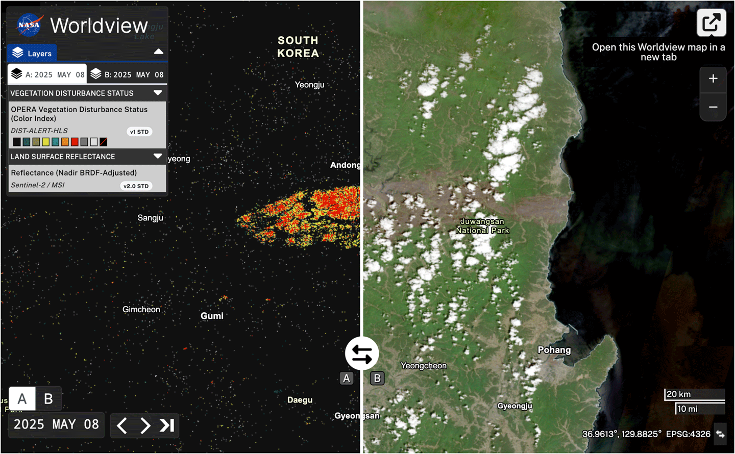
Figure 1. In March 2025, wildfires burned through South Korea, resulting in heavy vegetation loss. [left] Output of the DIST-ALERT product on NASA Worldview from May 8, 2025, with vegetation loss in percent flagged with varying levels of confidence. Yellow and red represent areas with confirmed vegetation cover losses of <50% and ≥50%, respectively. [right] Natural-color image captured by the Multi-Spectral Instrument (MSI) aboard Sentinel-2C on May 8, 2025. The large brown burn scar in the center of the image corresponds to vegetation loss detected by DIST-ALERT. It stands in contrast to the surrounding green vegetation.Figure credit: NASA EarthdataDisturbance alerts already exist in some ecosystems. Brazil’s National Institute for Space Research [Instituto Nacional de Pesquisas Espaciais (INPE)] runs two projects that detect deforestation in the Amazon: Programa de Cálculo do Desflorestamento da Amazônia (PRODES) and Sistema de Detecção de Desmatamento em Tempo Real (DETER). The GLAD lab created its own forest loss alerts – GLAD-L and GLAD-S2 – using Landsat and Sentinel-2 data respectively. Global Forest Watch integrates GLAD-L and GLAD-S2 data with Radar for Detecting Deforestation (RADD) observations – derived from synthetic aperture radar data from Copernicus Sentinel-1 – into an integrated deforestation alert.
The implementation of these alert systems, some of which have been around for decades, have been shown to impact deforestation rates in the tropics. For example, a 2021 study in Nature Climate Change found that deforestation alerts decreased the probability of deforestation in Central Africa by 18% relative to the average 2011–2016 levels.
DIST-ALERT is distinct from other alert systems in a few ways. First, it has global coverage. Second, the rolling baseline allows for tracking changes in seasonality and disturbances to dynamic ecosystems. When HLS V2.0 data are input to DIST-ALERT, the system is also better at identifying disturbances in cloudy ecosystems than other individual alert systems – because it is more likely to obtain clear observations. This also enables it to identify the start and end of the disturbance more precisely.
Pickens said that the DIST-ALERT team is already working with end-users who are implementing their data product. She has spoken to some who use the system to help logging companies prove that they are complying with regulations. The U.S. Census Bureau is also using DIST-ALERT to monitor fast-growing communities so that they can do targeted assessments in the interim between the larger decennial census.
Alongside DIST-ALERT, OPERA has also been developing the Dynamic Surface Water eXtent (DSWx) product suite, which employs HLS to track surface water (e.g., lakes, reservoirs, rivers, and floods) around the globe – see Figure 2. These new products represent the new applications made possible by the HLS interagency and international collaboration.
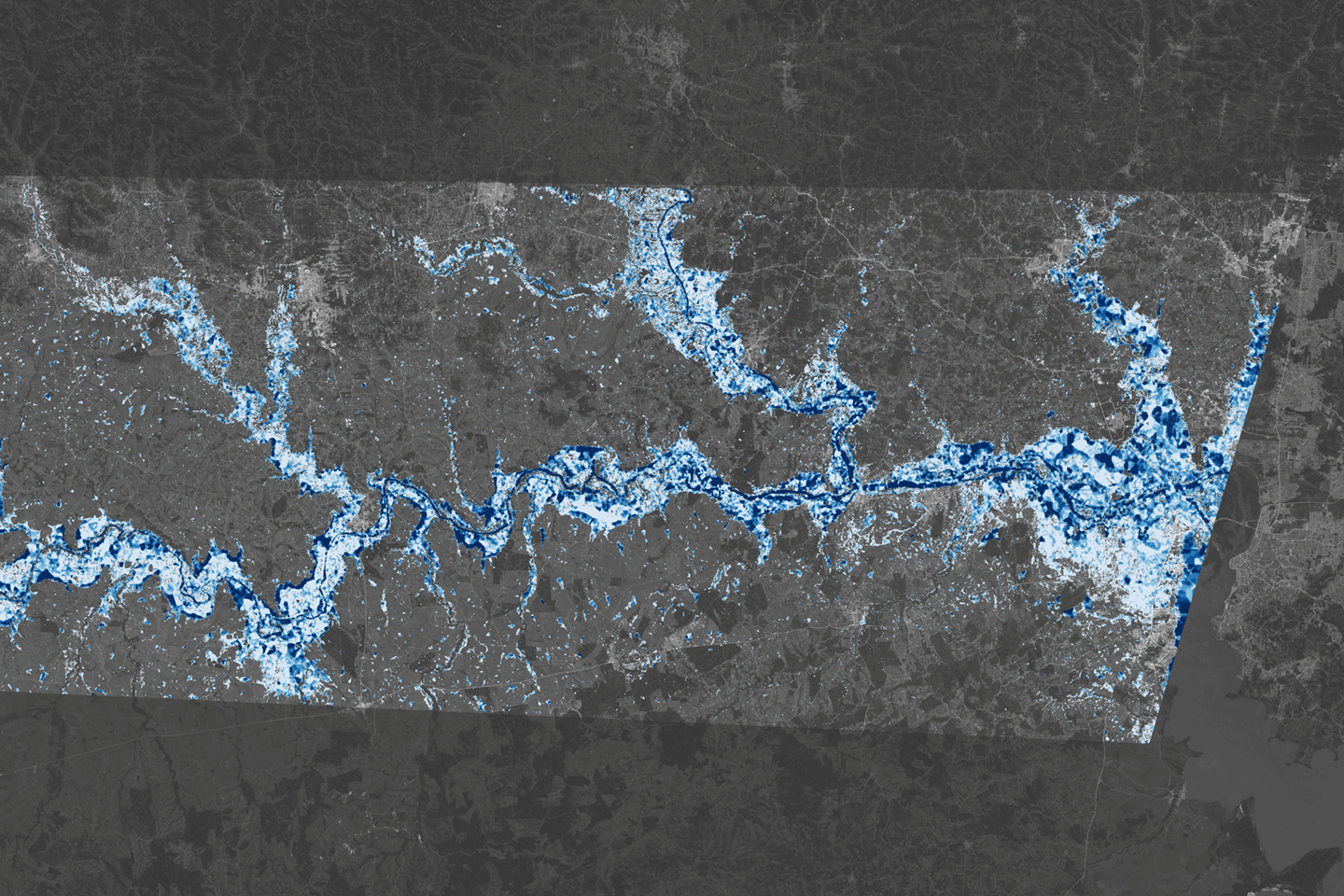
Figure 2. The map shows flood extent and estimates of flood depth in areas west of Porto Alegre, Brazil on May 6, 2024. The flood extent is from the Observational Products for End-Users from Remote Sensing Analysis (OPERA) Dynamic Surface Water eXtent product, which uses Harmonized Landsat Sentinel-2 data. The flood depth estimate is from the Floodwater Depth Estimation Tool (FwD ET). The darkest blue areas represent floodwater at least 5 m (20 ft) deep. Much of the inundated floodplain is light blue, which equates to depths of between 0.1–1 m (4–40 in).Figure credit: Lauren Dauphin [NASA’s Earth Observatory], Dinuke Munasinghe [JPL], Sagy Cohen [University of Alabama], and Alexander Handwerger [JPL]Conclusion
HLS is set to continue improving land monitoring efforts across the globe. Meanwhile, the HLS science team is working to improve the algorithms for a more seamless harmonization of Landsat 8 and 9 and Sentinel-2 data. They are also working to improve the cloud-masking algorithm, have recently released vegetation indices, and are working on developing a low-latency (six-hour) HLS surface reflectance product, all while incorporating user feedback.
Looking ahead, the launch of future Sentinel and Landsat satellites will further the development of HLS. The additional data and unique capabilities will continue to meet researchers’ need for more frequent, high-quality satellite observations of Earth’s land surface.
Madeleine Gregory
NASA’s Goddard Space Flight Center/Science Systems and Applications Inc.
madeleine.s.gregory@nasa.gov
Harmonized Landsat and Sentinel-2: Collaboration Drives Innovation
9 min read
Harmonized Landsat and Sentinel-2: Collaboration Drives InnovationIntroduction
Landsat, a joint program of NASA and the U.S. Geological Survey (USGS), has been an invaluable tool for monitoring changes in Earth’s land surface for over 50 years. Researchers use instruments on Landsat satellites to monitor decades-long trends, including urbanization and agricultural expansion, as well as short-term dynamics, including water use and disaster recovery. However, scientists and land managers often encounter one critical limitation of this program: Landsat has a revisit time of eight days (with Landsat 8 and 9 operating), which is too long to capture events and disasters that occur on short timescales. Floods, for example, can quickly inundate a region, and cloud cover from storms can delay Landsat’s ability to get a clear observation on damage.
In 2015, the European Space Agency’s (ESA) Copernicus Sentinel-2A mission joined Landsat 7 and 8 in orbit. It was designed to collect comparable optical land data with the intention of leveraging Landsat’s archive. Two years later, ESA launched Sentinel-2B, a satellite identical to Sentinel-2A.
Led by a science team at NASA’s Goddard Space Flight Center (GSFC), the USGS, NASA, and ESA began to work on combining the capabilities of Sentinel-2 and Landsat satellites. This idea was the impetus behind Harmonized Landsat and Sentinel-2 (HLS) project, a NASA initiative that created a seamless product from the Operational Land Imager (OLI) and Multi-Spectral Instrument (MSI) aboard Landsat and Sentinel-2 satellites, respectively. HLS Version 2.0 (V2.0) is the most recent version of these data and had a global median repeat frequency of 1.6 days in 2022 by combining observations from Landsat 8 and 9 and Sentinel-2A and B. The recent addition of Sentinel-2C data will provide even more frequent observations. With near-global coverage and improved harmonization algorithms, HLS V2.0 paves the way for new applications and improved land monitoring systems – see Animation 1. HLS data are available for download on NASA Earthdata: HLSL30v2.0 and HLSS30v2.0. These data can also be accessed through Google Earth Engine: HLSL30v2.0 and HLSS30v2.0.
Animation 1. This visualization shows the change in vegetation in Maryland from January 1 to December 30, 2016, using Normalized Difference Vegetation Index (NDVI) data from Harmonized Landsat Sentinel-2 (HLS). The visualization shows land on both sides of the Chesapeake Bay, where red represents bare soil and green indicates healthy, growing vegetation. Animation credit: Michael Taylor [Science Systems and Applications Inc. (SSAI)], Matthew Radcliff [USRA], and Jeffrey Masek [GSFC]. Caption adapted from Laura Rocchio [SSAI]The Dawn of HLS
The story of HLS begins before the launch of Sentinel-2A in 2015. Jeffrey Masek [GSFC], who was at that time project scientist for Landsat 8, led a group of researchers who wanted to find a way to harmonize Landsat data with other satellite data. Their aim was to create a “virtual constellation” similar to how weather satellites operate.
“HLS meets a need that people have been asking for for a long time,” said Masek.
What began as a research question with an experimental product evolved into an operational project with the involvement of the Satellite Needs Working Group (SNWG). SNWG is an interagency effort to develop solutions that address Earth observation needs of civilian federal agencies. Every two years, SNWG conducts a survey of federal agencies to see how their work could benefit from satellite data. The answers span the gamut of application areas, from water quality monitoring to disaster recovery to planning how best to protect and use natural resources. SNWG brings these ideas to NASA, USGS, and the National Oceanic and Atmospheric Administration (NOAA) – the three main U.S. government providers of satellite data. These agencies work together to create and implement solutions that serve those needs. NASA plays a critical role in every step of the SNWG process, including leading the assessment of survey responses from over 30 federal agencies, managing and supporting the implementation of identified solutions, and encouraging solution co-design with federal partners to maximize impact.
The HLS surface reflectance product was an outcome of the very first SNWG solution cycle in 2016. This product was expanded, following additional SNWG requests in 2020 and 2022. The 2020 cycle saw the creation of nine HLS-derived vegetation indices, and the 2022 cycle aimed for a six-hour latency product.
The U.S. Department of Agriculture (USDA) now uses HLS to map crop emergence at the field scale in the corn belt, allowing farmers to better plan their growing seasons. Ranchers in Colorado use the dataset to decide where to graze their cattle during periods of drought. HLS also informs the use and termination of cover crops in the Chesapeake Bay area. In 2024, the Federal Emergency Management Agency (FEMA) employed HLS to identify where to focus aid in the aftermath of Hurricane Helene.
A New and Improved HLS
In the July 2025 issue of Remote Sensing of Environment, a team of researchers outlined the HLS V2.0 surface reflectance dataset and algorithms. The team included seven NASA co-authors, members of the 2018–2023 Landsat Science Team, and ESA. The lead author, Junchang Ju [GSFC—Remote Sensing Scientist], has been the technical lead on HLS since its inception. Co-author Christopher Neigh [GSFC—Landsat 8/9 Project Scientist] is the principal investigator on the HLS project. V2.0, which was completed in Summer 2023, incorporates several major improvements over HLS V1.4, the most recent publicly available HLS product. HLS V1.4 covered about 30% of the global land area, providing data on North America and other select locations. HLS V2.0 provides data at a spatial resolution of 30 m (98 ft) with near-global coverage from 2013 onward. The dataset includes all land masses except Antarctica. HLS V2.0 also has key algorithmic improvements in atmospheric correction, cloud masking, and bidirectional reflectance distribution function (BRDF) correction. Together, these algorithms “harmonize” the data, or ensure that the distinct Landsat and Sentinel-2 datasets can effectively be used interchangeably – see Animation 2.
Animation 2: The visualization provides the Normalized Difference Vegetation Index (NDVI) data from Harmonized Landsat Sentinel-2 (HLS) for farm fields south of Columbus, NE. The red represents bare soil and green represents healthy, growing vegetation. The animation runs from January 1 to December 30, 2016. Animation credit: Michael Taylor [SSAI], Matthew Radcliff [USRA], and Jeffrey Masek [GSFC]. Caption adapted from Laura Rocchio [SSAI]HLS V2.0 in Action
The increased frequency of observations improved the ability of the scientific community to track disaster recovery, changes in phenology, agricultural intensification, rapid urban growth, logging, and deforestation. Researchers are already putting these advances to use.
The land disturbance product (DIST-ALERT) is a global land change monitoring system that uses HLS V2.0 data to track vegetation anomalies in near real-time – see Figure 1. DIST-ALERT captures agricultural expansion, urban growth, fire, flooding, logging, drought, landslides, and other forces of change to vegetation. Amy Pickens [University of Maryland, Department of Geographical Sciences—Assistant Research Professor] said that HLS is the perfect dataset for tracking disturbances because of the frequency of observations.
DIST-ALERT was created through Observational Products for End-Users from Remote Sensing Analysis (OPERA), a project at NASA/Jet Propulsion Laboratory (JPL). OPERA products respond to agency needs identified by the SNWG. In 2018, SNWG identified tracking surface disturbance as a key need. OPERA partnered with the Global Land Analysis and Discovery (GLAD) lab at University of Maryland to develop the change detection algorithm.
To track changes in vegetation, the DIST-ALERT system establishes a rolling baseline – meaning that for any given pixel, the vegetation cover is compared against vegetation cover from the same 31-day window in the previous three years. The primary algorithm detects any vegetation loss relative to the established baseline. A secondary algorithm flags any spectral anomaly (i.e., any change in reflectance) compared to that same baseline. This approach ensures that the algorithm catches non-vegetation change (e.g., new building or road projects in unvegetated areas). Used together, these algorithms can identify long-term changes in agricultural expansion, deforestation, and urbanization alongside short-term changes in crop harvest, drought, selective logging, and the impacts of disasters. On average, DIST-ALERT is made available on LP DAAC within six hours of when new HLS data is available. Currently, the dataset does not provide attribution to disturbances.
Figure 1. In March 2025, wildfires burned through South Korea, resulting in heavy vegetation loss. [left] Output of the DIST-ALERT product on NASA Worldview from May 8, 2025, with vegetation loss in percent flagged with varying levels of confidence. Yellow and red represent areas with confirmed vegetation cover losses of <50% and ≥50%, respectively. [right] Natural-color image captured by the Multi-Spectral Instrument (MSI) aboard Sentinel-2C on May 8, 2025. The large brown burn scar in the center of the image corresponds to vegetation loss detected by DIST-ALERT. It stands in contrast to the surrounding green vegetation. Figure credit: NASA EarthdataDisturbance alerts already exist in some ecosystems. Brazil’s National Institute for Space Research [Instituto Nacional de Pesquisas Espaciais (INPE)] runs two projects that detect deforestation in the Amazon: Programa de Cálculo do Desflorestamento da Amazônia (PRODES) and Sistema de Detecção de Desmatamento em Tempo Real (DETER). The GLAD lab created its own forest loss alerts – GLAD-L and GLAD-S2 – using Landsat and Sentinel-2 data respectively. Global Forest Watch integrates GLAD-L and GLAD-S2 data with Radar for Detecting Deforestation (RADD) observations – derived from synthetic aperture radar data from Copernicus Sentinel-1 – into an integrated deforestation alert.
The implementation of these alert systems, some of which have been around for decades, have been shown to impact deforestation rates in the tropics. For example, a 2021 study in Nature Climate Change found that deforestation alerts decreased the probability of deforestation in Central Africa by 18% relative to the average 2011–2016 levels.
DIST-ALERT is distinct from other alert systems in a few ways. First, it has global coverage. Second, the rolling baseline allows for tracking changes in seasonality and disturbances to dynamic ecosystems. When HLS V2.0 data are input to DIST-ALERT, the system is also better at identifying disturbances in cloudy ecosystems than other individual alert systems – because it is more likely to obtain clear observations. This also enables it to identify the start and end of the disturbance more precisely.
Pickens said that the DIST-ALERT team is already working with end-users who are implementing their data product. She has spoken to some who use the system to help logging companies prove that they are complying with regulations. The U.S. Census Bureau is also using DIST-ALERT to monitor fast-growing communities so that they can do targeted assessments in the interim between the larger decennial census.
Alongside DIST-ALERT, OPERA has also been developing the Dynamic Surface Water eXtent (DSWx) product suite, which employs HLS to track surface water (e.g., lakes, reservoirs, rivers, and floods) around the globe – see Figure 2. These new products represent the new applications made possible by the HLS interagency and international collaboration.
Figure 2. The map shows flood extent and estimates of flood depth in areas west of Porto Alegre, Brazil on May 6, 2024. The flood extent is from the Observational Products for End-Users from Remote Sensing Analysis (OPERA) Dynamic Surface Water eXtent product, which uses Harmonized Landsat Sentinel-2 data. The flood depth estimate is from the Floodwater Depth Estimation Tool (FwD ET). The darkest blue areas represent floodwater at least 5 m (20 ft) deep. Much of the inundated floodplain is light blue, which equates to depths of between 0.1–1 m (4–40 in). Figure credit: Lauren Dauphin [NASA’s Earth Observatory], Dinuke Munasinghe [JPL], Sagy Cohen [University of Alabama], and Alexander Handwerger [JPL]Conclusion
HLS is set to continue improving land monitoring efforts across the globe. Meanwhile, the HLS science team is working to improve the algorithms for a more seamless harmonization of Landsat 8 and 9 and Sentinel-2 data. They are also working to improve the cloud-masking algorithm, have recently released vegetation indices, and are working on developing a low-latency (six-hour) HLS surface reflectance product, all while incorporating user feedback.
Looking ahead, the launch of future Sentinel and Landsat satellites will further the development of HLS. The additional data and unique capabilities will continue to meet researchers’ need for more frequent, high-quality satellite observations of Earth’s land surface.
Madeleine Gregory
NASA’s Goddard Space Flight Center/Science Systems and Applications Inc.
madeleine.s.gregory@nasa.gov
NASA Implementation of Executive Order 14303
Aug 22, 2025
PDF (277.15 KB)
NASA Implementation of Executive Order 14303
Aug 22, 2025
PDF (277.15 KB)
Lindy Garay: Supporting Space Station Safety and Success
Lindy Garay always knew she wanted to develop software. She did not anticipate that her work would contribute to human spaceflight.
The electrical and software engineering degree Garay earned from the University of Texas at Austin paved the way for a 25-year career with NASA’s Johnson Space Center in Houston. Her first job out of college was developing software for the International Space Station Program’s original space station training facility simulator. “I had not always been interested in working in the space program, but I became enamored with being able to contribute to such an important mission,” she said.
Official portrait of Lindy Garay.NASAToday, Garay serves as a training systems software architect and is the technical lead for training system external interfaces. That means she leads the team that helps connect training simulations from NASA’s external partners with simulations run by Johnson’s Mission Training Center (MTC) to support crew and flight controller training. The MTC currently provides training capabilities for the International Space Station Program, the Commercial Crew Program, and Artemis campaign components such as the Orion Program and the human landing system.
Garay said that not having an aerospace background was challenging at the beginning of her career, but she overcame that by leaning on teammates who had knowledge and experience in the field. “Every successful endeavor depends on having a solid team of dedicated people working toward one goal,” she said. “Success also depends on good communication, flexibility, and being willing to listen to different opinions,” she added.
Garay was recently named as a 2025 NASA Space Flight Awareness Program Honoree – one of the highest recognitions presented to the agency’s workforce. Recipients must have significantly contributed to the human spaceflight program to ensure flight safety and mission success. Garay’s commendation acknowledged her “sustained superior performance, dedication, and commitment to the Flight Operations Directorate’s goals” and her instrumental role in the success of several major training systems projects. In particular, she was recognized for contributions to the High-Level Architecture simulation framework, which is used to create realistic simulations of visiting vehicles’ arrival, docking, and departure from the space station.
From left to right, Johnson Space Flight Awareness (SFA) Lead Jessica Cordero, SFA Coordinator Michelle Minor, Johnson Space Center Acting Director Stephen Koerner, Drew Faulkner, Adam Korona, Teresa Sindelar, Lindy Garay, Lindsay Kirk, Keith Barr, Ephram Rubin, and NASA astronaut Randy Bresnik. NASA/Kim ShiflettGaray and 36 other agency honorees were celebrated during a special ceremony in Cocoa Beach, Florida, and had the opportunity to attend the launch of NASA’s SpaceX Crew-10 mission at NASA’s Kennedy Space Center. “That was quite an honor,” she said.
Outside of work, Garay may be found cheering on Houston’s sports teams. She enjoys traveling to watch the Texans and the Astros play.
Garay is also rooting for the Artemis Generation as NASA prepares to return to the Moon and journey on to Mars. She offered this advice: “Always remember the importance and the magnitude of the whole mission.”
Explore More 4 min read Washington State Student Wins 2025 NASA Art Contest Article 14 hours ago 1 min read NASA Implementation of Executive Order 14303 Article 15 hours ago 3 min read NASA Shares Final Contenders for Artemis II Moon Mascot Design Contest Article 4 days agoLindy Garay: Supporting Space Station Safety and Success
Lindy Garay always knew she wanted to develop software. She did not anticipate that her work would contribute to human spaceflight.
The electrical and software engineering degree Garay earned from the University of Texas at Austin paved the way for a 25-year career with NASA’s Johnson Space Center in Houston. Her first job out of college was developing software for the International Space Station Program’s original space station training facility simulator. “I had not always been interested in working in the space program, but I became enamored with being able to contribute to such an important mission,” she said.
Official portrait of Lindy Garay.NASAToday, Garay serves as a training systems software architect and is the technical lead for training system external interfaces. That means she leads the team that helps connect training simulations from NASA’s external partners with simulations run by Johnson’s Mission Training Center (MTC) to support crew and flight controller training. The MTC currently provides training capabilities for the International Space Station Program, the Commercial Crew Program, and Artemis campaign components such as the Orion Program and the human landing system.
Garay said that not having an aerospace background was challenging at the beginning of her career, but she overcame that by leaning on teammates who had knowledge and experience in the field. “Every successful endeavor depends on having a solid team of dedicated people working toward one goal,” she said. “Success also depends on good communication, flexibility, and being willing to listen to different opinions,” she added.
Garay was recently named as a 2025 NASA Space Flight Awareness Program Honoree – one of the highest recognitions presented to the agency’s workforce. Recipients must have significantly contributed to the human spaceflight program to ensure flight safety and mission success. Garay’s commendation acknowledged her “sustained superior performance, dedication, and commitment to the Flight Operations Directorate’s goals” and her instrumental role in the success of several major training systems projects. In particular, she was recognized for contributions to the High-Level Architecture simulation framework, which is used to create realistic simulations of visiting vehicles’ arrival, docking, and departure from the space station.
From left to right, Johnson Space Flight Awareness (SFA) Lead Jessica Cordero, SFA Coordinator Michelle Minor, Johnson Space Center Acting Director Stephen Koerner, Drew Faulkner, Adam Korona, Teresa Sindelar, Lindy Garay, Lindsay Kirk, Keith Barr, Ephram Rubin, and NASA astronaut Randy Bresnik. NASA/Kim ShiflettGaray and 36 other agency honorees were celebrated during a special ceremony in Cocoa Beach, Florida, and had the opportunity to attend the launch of NASA’s SpaceX Crew-10 mission at NASA’s Kennedy Space Center. “That was quite an honor,” she said.
Outside of work, Garay may be found cheering on Houston’s sports teams. She enjoys traveling to watch the Texans and the Astros play.
Garay is also rooting for the Artemis Generation as NASA prepares to return to the Moon and journey on to Mars. She offered this advice: “Always remember the importance and the magnitude of the whole mission.”
Explore More 3 min read NASA Shares Final Contenders for Artemis II Moon Mascot Design Contest Article 3 days ago 5 min read NASA’s Bennu Samples Reveal Complex Origins, Dramatic TransformationAsteroid Bennu, sampled by NASA’s OSIRIS-REx mission in 2020, is a mixture of dust that…
Article 3 days ago 4 min read NASA’s Artemis II Lunar Science Operations to Inform Future MissionsWhile the Artemis II crew will be the first humans to test NASA’s Orion spacecraft…
Article 4 days agoNASA Science, Cargo Launch on 33rd SpaceX Resupply Mission to Station
Following a successful launch of NASA’s SpaceX 33rd commercial resupply mission, new scientific experiments and cargo for the agency are bound for the International Space Station.
The SpaceX Dragon spacecraft, carrying more than 5,000 pounds of supplies to the orbiting laboratory, lifted off at 2:45 a.m. EDT on Sunday, on the company’s Falcon 9 rocket from Space Launch Complex 40 at Cape Canaveral Space Force Station in Florida.
“Commercial resupply missions to the International Space Station deliver science that helps prove technologies for Artemis lunar missions and beyond,” said acting NASA Administrator Sean Duffy. “This flight will test 3D printing metal parts and bioprinting tissue in microgravity – technology that could give astronauts tools and medical support on future Moon and Mars missions.”
Live coverage of the spacecraft’s arrival will begin at 6 a.m., Monday, Aug. 25, on NASA+, Netflix, Amazon Prime, and more. Learn how to watch NASA content through a variety of platforms, including social media.
The spacecraft is scheduled to dock autonomously at approximately 7:30 a.m. to the forward port of the space station’s Harmony module.
In addition to food, supplies, and equipment for the crew, Dragon will deliver several experiments, including bone-forming stem cells for studying bone loss prevention and materials, to 3D print medical implants that could advance treatments for nerve damage on Earth. Dragon also will deliver bioprinted liver tissue to study blood vessel development in microgravity, as well as supplies to 3D print metal cubes in space.
These are just a sample of the hundreds of biology and biotechnology, physical sciences, Earth and space science investigations conducted aboard the orbiting laboratory. This research benefits people on Earth while laying the groundwork for other agency deep space missions. As part of NASA’s Artemis campaign, the agency will send astronauts to the Moon to prepare for future human exploration of Mars, inspiring the world through discovery in a new Golden Age of innovation and exploration.
During the mission, Dragon also will perform a reboost demonstration of station to maintain its current altitude. The hardware, located in the trunk of Dragon, contains an independent propellant system separate from the spacecraft to fuel two Draco engines using existing hardware and propellant system design. The boost kit will help sustain the orbiting lab’s altitude starting in September with a series of burns planned periodically throughout the fall of 2025. During NASA’s SpaceX 31st commercial resupply services mission on Nov. 8, 2024, the Dragon spacecraft performed its first demonstration of these capabilities.
The Dragon spacecraft is scheduled to remain at the space station until December, when it will depart the orbiting laboratory and return to Earth with research and cargo, splashing down off the coast of California.
Learn more about the International Space Station at:
https://www.nasa.gov/international-space-station
-end-
Joshua Finch
Headquarters, Washington
202-358-1100
joshua.a.finch@nasa.gov
Steven Siceloff
Kennedy Space Center, Fla.
321-876-2468
steven.p.siceloff@nasa.gov
Sandra Jones / Joseph Zakrzewski
Johnson Space Center, Houston
281-483-5111
sandra.p.jones@nasa.gov / joseph.a.zakrzewski@nasa.gov
NASA Science, Cargo Launch on 33rd SpaceX Resupply Mission to Station
Following a successful launch of NASA’s SpaceX 33rd commercial resupply mission, new scientific experiments and cargo for the agency are bound for the International Space Station.
The SpaceX Dragon spacecraft, carrying more than 5,000 pounds of supplies to the orbiting laboratory, lifted off at 2:45 a.m. EDT on Sunday, on the company’s Falcon 9 rocket from Space Launch Complex 40 at Cape Canaveral Space Force Station in Florida.
“Commercial resupply missions to the International Space Station deliver science that helps prove technologies for Artemis lunar missions and beyond,” said acting NASA Administrator Sean Duffy. “This flight will test 3D printing metal parts and bioprinting tissue in microgravity – technology that could give astronauts tools and medical support on future Moon and Mars missions.”
Live coverage of the spacecraft’s arrival will begin at 6 a.m., Monday, Aug. 25, on NASA+, Netflix, Amazon Prime, and more. Learn how to watch NASA content through a variety of platforms, including social media.
The spacecraft is scheduled to dock autonomously at approximately 7:30 a.m. to the forward port of the space station’s Harmony module.
In addition to food, supplies, and equipment for the crew, Dragon will deliver several experiments, including bone-forming stem cells for studying bone loss prevention and materials, to 3D print medical implants that could advance treatments for nerve damage on Earth. Dragon also will deliver bioprinted liver tissue to study blood vessel development in microgravity, as well as supplies to 3D print metal cubes in space.
These are just a sample of the hundreds of biology and biotechnology, physical sciences, Earth and space science investigations conducted aboard the orbiting laboratory. This research benefits people on Earth while laying the groundwork for other agency deep space missions. As part of NASA’s Artemis campaign, the agency will send astronauts to the Moon to prepare for future human exploration of Mars, inspiring the world through discovery in a new Golden Age of innovation and exploration.
During the mission, Dragon also will perform a reboost demonstration of station to maintain its current altitude. The hardware, located in the trunk of Dragon, contains an independent propellant system separate from the spacecraft to fuel two Draco engines using existing hardware and propellant system design. The boost kit will help sustain the orbiting lab’s altitude starting in September with a series of burns planned periodically throughout the fall of 2025. During NASA’s SpaceX 31st commercial resupply services mission on Nov. 8, 2024, the Dragon spacecraft performed its first demonstration of these capabilities.
The Dragon spacecraft is scheduled to remain at the space station until December, when it will depart the orbiting laboratory and return to Earth with research and cargo, splashing down off the coast of California.
Learn more about the International Space Station at:
https://www.nasa.gov/international-space-station
-end-
Joshua Finch
Headquarters, Washington
202-358-1100
joshua.a.finch@nasa.gov
Steven Siceloff
Kennedy Space Center, Fla.
321-876-2468
steven.p.siceloff@nasa.gov
Sandra Jones / Joseph Zakrzewski
Johnson Space Center, Houston
281-483-5111
sandra.p.jones@nasa.gov / joseph.a.zakrzewski@nasa.gov
NASA Tests Tools to Assess Drone Safety Over Cities
2 min read
Preparations for Next Moonwalk Simulations Underway (and Underwater) ResilienX employees Angelo Niforatos, left, and Ryan Pleskach, right, overview the NASA safety tools integrated into the company’s commercial system, July 11, 2025, at the ResilienX Headquarters in Syracuse, New York. Credit: ResilienXA future with advanced air mobility aircraft populating the skies will require the U.S. to implement enhanced preflight planning that can mitigate potential risks well before takeoff – and NASA is working to develop the tools to make that happen.
Preflight planning is critical to ensuring safety in the complex, high-risk environments of the future airspace. Timely, predictive, and up-to-date risk assessment within a single platform makes it much easier for drone or air taxi operators to check flight plans for high-risk concerns.
NASA is working on tools to deliver those services, and in June, the agency and aviation safety company ResilienX Inc. demonstrated how these tools can be integrated into commercial systems.
During a series of tests conducted at ResilienX’s facility in Syracuse, New York, researchers used NASA services that allowed flight operators to submit flight plans prior to departure, obtain risk assessment results, and then decide whether to proceed with flights or change their flight plans and re-assess risks. Allowing operators to perform these tasks quickly reduces the safety risk to flight passengers as well as humans on the ground.
The three NASA-developed services are intended to assess unique risks associated with highly automated aircraft flying at low altitudes over cities.
The partnership was managed under a Phase III NASA Small Business Innovation Research (SBIR) contract, which is an extension of prior work to assess weather-related risks. This collaboration is already leading to direct technology transfer of safety systems into ResilienX’s platform. The partnership is also intended to provide indirect benefits for ResilienX partners and customers, such as the U.S. Air Force and regional operators, helping to advance the overall safety of future airspace operations.
This work is led by NASA’s System-Wide Safety project under the Airspace Operations and Safety program in support of the agency’s Advanced Air Mobility mission. The mission seeks to deliver data, findings, and recommendations to guide the industry’s development of future air taxis and drones.
Share Details Last Updated Aug 22, 2025 EditorDede DiniusContactTeresa Whitingteresa.whiting@nasa.gov Related Terms Explore More 5 min read National Aviation Day: Celebrating NASA’s Heritage While Charting Our Future Article 6 days ago 5 min read NASA Invites You to Celebrate National Aviation Day 2025 Article 6 days ago 4 min read NASA Tests Research Aircraft to Improve Air Taxi Flight Controls Article 2 weeks ago Keep Exploring Discover More Topics From NASAArmstrong Flight Research Center
Humans in Space
Climate Change
Solar System
La NASA revela los finalistas del concurso de diseño de la mascota lunar de Artemis II
Read this story in English here.
La NASA ya tiene 25 finalistas para el diseño del indicador de gravedad cero de Artemis II que volará con la tripulación de esta misión alrededor de la Luna y de regreso a la Tierra el próximo año.
Los astronautas Reid Wiseman, Victor Glover y Christina Koch de la NASA, y el astronauta de la CSA (Agencia Espacial Canadiense) Jeremy Hansen pronto seleccionarán uno de los diseños finalistas para que les acompañe dentro de la nave espacial Orion como su mascota lunar.
“El indicador de gravedad cero de Artemis II será especial para la tripulación”, dijo Reid Wiseman, comandante de Artemis II. “En una nave espacial llena de equipos y herramientas complejas que mantienen viva a la tripulación en el espacio profundo, el indicador es una forma amigable y útil de resaltar el elemento humano que es tan crítico para nuestra exploración del universo. Nuestra tripulación está entusiasmada con estos diseños provenientes de muchos lugares del mundo y esperamos con interés llevar al ganador con nosotros en este viaje”.
Un indicador de gravedad cero es un pequeño peluche que típicamente viaja con la tripulación para indicar visualmente el momento en que llegan al espacio. Durante los primeros ocho minutos después del despegue, la tripulación y el indicador, que estará situado cerca de ellos, seguirán siendo presionados contra sus asientos por la gravedad y la fuerza de la subida al espacio. Cuando se apaguen los motores principales de la etapa central del cohete Sistema de Lanzamiento Espacial (SLS, por sus siglas en inglés), se eliminarán las restricciones de la gravedad, pero la tripulación seguirá atada de manera segura a sus asientos: la capacidad de flotar de su indicador de gravedad cero será la evidencia de que han llegado al espacio.
Artemis II será la primera misión en la que el público haya participado en la creación de la mascota de la tripulación.
Estos diseños, con ideas que abarcan desde versiones lunares de criaturas terrestres hasta visiones creativas sobre la exploración y el descubrimiento, fueron seleccionados entre más de 2.600 propuestas procedentes de más de 50 países, e incluyen diseños de estudiantes desde primaria a secundaria. Los finalistas representan a 10 países, entre los que están Estados Unidos, Canadá, Colombia, Finlandia, Francia, Alemania, Japón, Perú, Singapur y Gales.
Mira aquí los diseños finalistas:
En marzo, la NASA anunció que buscaba propuestas de creadores de todo el mundo para el diseño de un indicador de gravedad cero que volaría a bordo de Artemis II, la primera misión tripulada de la campaña Artemis de la NASA. Se pidió a los creadores que presentaran ideas que representaran la importancia de Artemis, la misión, o la exploración y el descubrimiento, y que cumplieran con requisitos específicos de tamaño y materiales. La empresa de crowdsourcing (colaboración abierta) Freelancer sirvió como facilitadora del concurso en nombre de la NASA, a través del Laboratorio de Campeonatos de la NASA, el cual es gestionado por la Dirección de Misiones de Tecnología Espacial de la agencia.
Una vez que la tripulación haya seleccionado un diseño final, el Laboratorio de Mantas Térmicas de la NASA lo fabricará para el vuelo. El indicador estará amarrado dentro de Orion antes del lanzamiento.
La misión, que tendrá alrededor de 10 días de duración, es otro paso adelante hacia misiones en la superficie lunar y sirve como preparación para futuras misiones tripuladas a Marte de la agencia.
Mediante Artemis II, la NASA enviará astronautas a explorar la Luna para llevar a cabo descubrimientos científicos, obtener beneficios económicos y sentar las bases para las primeras misiones tripuladas a Marte.
NASA Shares Final Contenders for Artemis II Moon Mascot Design Contest
Lee esta historia en español aquí.
NASA is down to 25 finalists for the Artemis II zero gravity indicator set to fly with the mission’s crew around the Moon and back next year.
Astronauts Reid Wiseman, Victor Glover, and Christina Koch of NASA, and CSA (Canadian Space Agency) astronaut Jeremy Hansen will soon select one of the finalist designs to join them inside the Orion spacecraft as their Moon mascot.
“The Artemis II zero gravity indicator will be special for the crew,” said Reid Wiseman, Artemis II commander. “In a spacecraft filled with complex hardware to keep the crew alive in deep space, the indicator is a friendly and useful way to highlight the human element that is so critical to our exploration of the universe. Our crew is excited about these designs from across the world and we are looking forward to bringing the winner along for the ride.”
A zero gravity indicator is a small plush item that typically rides with a crew to visually indicate when they are in space. For the first eight minutes after liftoff, the crew and their indicator nearby will still be pushed into their seats by gravity, and the force of the climb into space. When the main engines of the SLS (Space Launch System) rocket’s core stage cut off, gravity’s restraints are lifted, but the crew will still be strapped safely into their seats – their zero gravity indicator’s ability to float will provide proof that they’ve made it into space.
Artemis II will mark the first time that the public has had a hand in creating the crew’s mascot.
These designs – ideas spanning from Moon-related twists on Earthly creatures to creative visions of exploration and discovery – were selected from more than 2,600 submissions from over 50 countries, including from K-12 students. The finalists represent 10 countries including the United States, Canada, Colombia, Finland, France, Germany, Japan, Peru, Singapore, and Wales.
View the finalist designs:
In March, NASA announced it was seeking design ideas from global creators for a zero gravity indicator to fly aboard Artemis II, the first crewed mission under NASA’s Artemis campaign. Creators were asked to submit ideas representing the significance of Artemis, the mission, or exploration and discovery, and to meet specific size and materials requirements. Crowdsourcing company Freelancer facilitated the contest on NASA’s behalf though the NASA Tournament Lab, managed by the agency’s Space Technology Mission Directorate.
Once the crew has selected a final design, NASA’s Thermal Blanket Lab will fabricate it for flight. The indicator will be tethered inside Orion before launch.
The approximately 10-day mission is another step toward missions on the lunar surface and helping the agency prepare for future human missions to Mars.
Through Artemis, NASA will send astronauts to explore the Moon for scientific discovery, economic benefits, and to build the foundation for the first crewed missions to Mars.
Epic Research Can Help Mars Missions
Epic Research Can Help Mars Missions
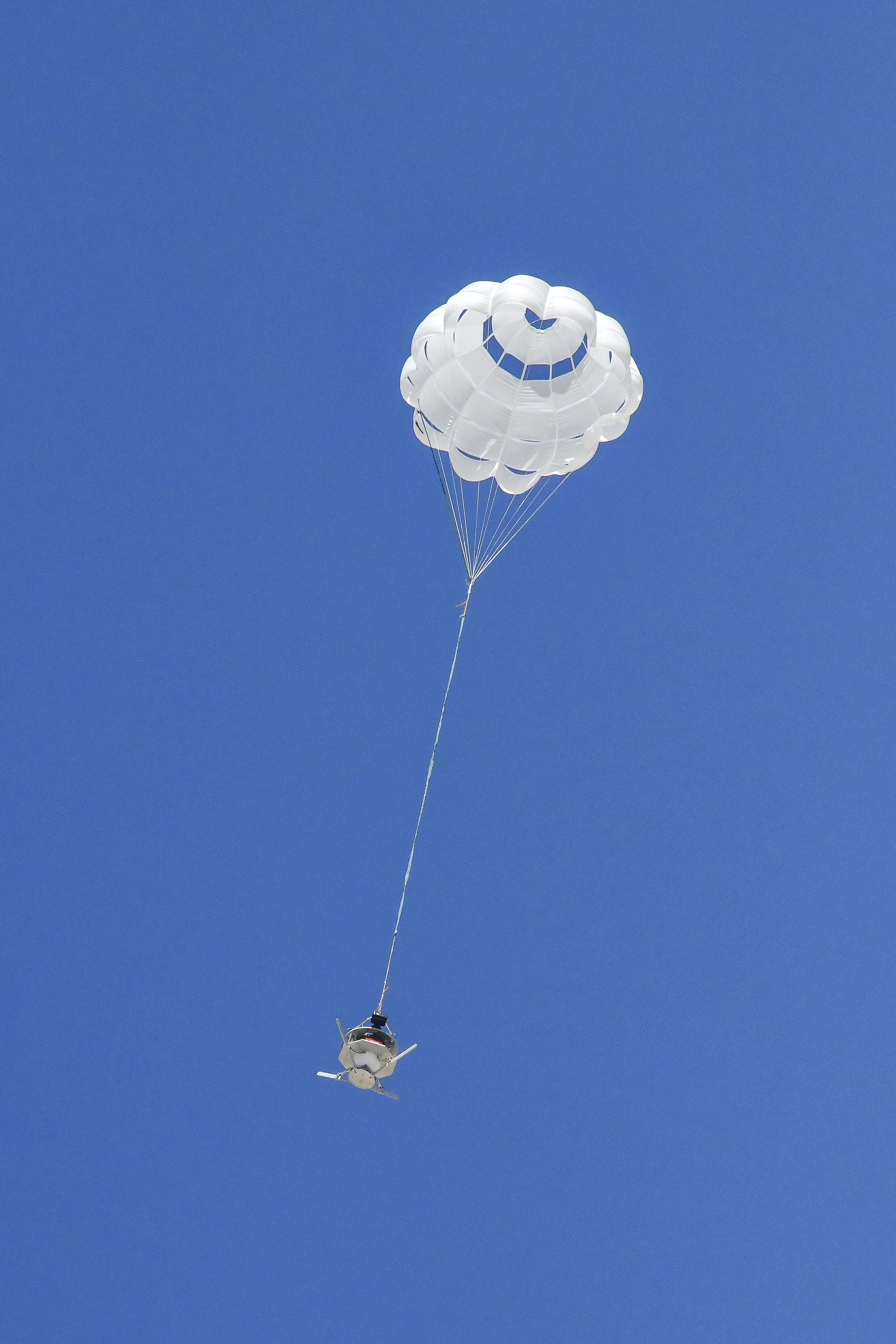
The parachute of the Enhancing Parachutes by Instrumenting the Canopy, or EPIC, test experiment deploys following an air launch from an Alta X drone on June 4, 2025, at NASA’s Armstrong Flight Research Center in Edwards, California. NASA researchers are developing technology to make supersonic parachutes safer and more reliable for delivering instruments and payloads to Mars.
The flight tests were a first step toward filling gaps in computer models to improve supersonic parachutes. This work could also open the door to future partnerships, including with the aerospace and auto racing industries.
Image Credit: NASA/Christopher LC Clark
