Feed aggregator
NASA to Welcome Fourth Private Astronaut Mission to Space Station
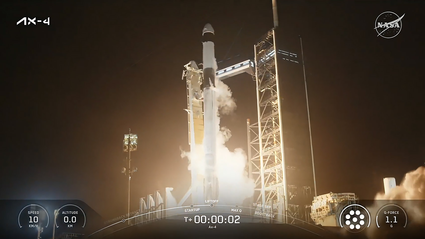
As part of NASA’s efforts to expand access to space, four private astronauts are in orbit following the successful launch of the fourth all private astronaut mission to the International Space Station.
A SpaceX Dragon spacecraft lifted off at 2:31 a.m. EDT Wednesday from Launch Complex 39A at NASA’s Kennedy Space Center in Florida, carrying Axiom Mission 4 crew members Peggy Whitson, former NASA astronaut and director of human spaceflight at Axiom Space as commander, ISRO (Indian Space Research Organisation) astronaut and pilot Shubhanshu Shukla, and mission specialists ESA (European Space Agency) project astronaut Sławosz Uznański-Wiśniewski of Poland and HUNOR (Hungarian to Orbit) astronaut Tibor Kapu of Hungary.
“Congratulations to Axiom Space and SpaceX on a successful launch,” said NASA acting Administrator Janet Petro. “Under President Donald Trump’s leadership, America has expanded international participation and commercial capabilities in low Earth orbit. U.S. industry is enabling astronauts from India, Poland, and Hungary to return to space for the first time in over forty years. It’s a powerful example of American leadership bringing nations together in pursuit of science, discovery, and opportunity.”
A collaboration between NASA and ISRO allowed Axiom Mission 4 to deliver on a commitment highlighted by President Trump and Indian Prime Minister Narendra Modi to send the first ISRO astronaut to the station. The space agencies are participating in five joint science investigations and two in-orbit science, technology, engineering, and mathematics demonstrations. NASA and ISRO have a long-standing relationship built on a shared vision to advance scientific knowledge and expand space collaboration.
This mission serves as an example of the success derived from collaboration between NASA’s international partners and American commercial space companies.
Live coverage of the spacecraft’s arrival will begin at 5 a.m., Thursday, June 26, on NASA+. Learn how to watch NASA content through a variety of platforms, including social media.
The spacecraft is scheduled to autonomously dock at approximately 7 a.m. to the space-facing port of the space station’s Harmony module.
Once aboard the station, Expedition 73 crew members, including NASA astronauts, Nicole Ayers, Anne McClain, and Jonny Kim, JAXA (Japan Aerospace Exploration Agency) astronaut Takuya Onishi, and Roscosmos cosmonauts Kirill Peskov, Sergey Ryzhikov, and Alexey Zubritsky will welcome the astronauts.
The crew is scheduled to remain at the space station, conducting microgravity research, educational outreach, and commercial activities for about two weeks before a return to Earth and splashdown off the coast of California.
The International Space Station is a springboard for developing a low Earth economy. NASA’s goal is to achieve a strong economy off the Earth where the agency can purchase services as one of many customers to meet its science and research objectives in microgravity. NASA’s commercial strategy for low Earth orbit provides the government with reliable and safe services at a lower cost, empowers U.S. industry, and enables the agency to focus on Artemis missions to the Moon in preparation for Mars while also continuing to use low Earth orbit as a training and proving ground for those deep space missions.
Learn more about NASA’s commercial space strategy at:
https://www.nasa.gov/commercial-space
-end-
Josh Finch
Headquarters, Washington
202-358-1100
joshua.a.finch@nasa.gov
Anna Schneider
Johnson Space Center, Houston
281-483-5111
anna.c.schneider@nasa.gov
NASA to Welcome Fourth Private Astronaut Mission to Space Station
Editor’s note: This advisory was updated June 26, 2025, to reflect a change in the docking coverage on NASA+ for Axiom Mission 4, as well as the Dragon spacecraft’s arrival at the International Space Station.
As part of NASA’s efforts to expand access to space, four private astronauts are in orbit following the successful launch of the fourth all private astronaut mission to the International Space Station.
A SpaceX Dragon spacecraft lifted off at 2:31 a.m. EDT Wednesday from Launch Complex 39A at NASA’s Kennedy Space Center in Florida, carrying Axiom Mission 4 crew members Peggy Whitson, former NASA astronaut and director of human spaceflight at Axiom Space as commander, ISRO (Indian Space Research Organisation) astronaut and pilot Shubhanshu Shukla, and mission specialists ESA (European Space Agency) project astronaut Sławosz Uznański-Wiśniewski of Poland and HUNOR (Hungarian to Orbit) astronaut Tibor Kapu of Hungary.
“Congratulations to Axiom Space and SpaceX on a successful launch,” said NASA acting Administrator Janet Petro. “Under President Donald Trump’s leadership, America has expanded international participation and commercial capabilities in low Earth orbit. U.S. industry is enabling astronauts from India, Poland, and Hungary to return to space for the first time in over forty years. It’s a powerful example of American leadership bringing nations together in pursuit of science, discovery, and opportunity.”
A collaboration between NASA and ISRO allowed Axiom Mission 4 to deliver on a commitment highlighted by President Trump and Indian Prime Minister Narendra Modi to send the first ISRO astronaut to the station. The space agencies are participating in five joint science investigations and two in-orbit science, technology, engineering, and mathematics demonstrations. NASA and ISRO have a long-standing relationship built on a shared vision to advance scientific knowledge and expand space collaboration.
This mission serves as an example of the success derived from collaboration between NASA’s international partners and American commercial space companies.
Live coverage of the spacecraft’s arrival will begin at 4:30 a.m., Thursday, June 26, on NASA+. Learn how to watch NASA content through a variety of platforms, including social media.
The spacecraft is ahead of schedule and may autonomously dock about 30 minutes early at approximately 6:30 a.m. to the space-facing port of the space station’s Harmony module.
Once aboard the station, Expedition 73 crew members, including NASA astronauts, Nicole Ayers, Anne McClain, and Jonny Kim, JAXA (Japan Aerospace Exploration Agency) astronaut Takuya Onishi, and Roscosmos cosmonauts Kirill Peskov, Sergey Ryzhikov, and Alexey Zubritsky will welcome the astronauts.
The crew is scheduled to remain at the space station, conducting microgravity research, educational outreach, and commercial activities for about two weeks before a return to Earth and splashdown off the coast of California.
The International Space Station is a springboard for developing a low Earth economy. NASA’s goal is to achieve a strong economy off the Earth where the agency can purchase services as one of many customers to meet its science and research objectives in microgravity. NASA’s commercial strategy for low Earth orbit provides the government with reliable and safe services at a lower cost, empowers U.S. industry, and enables the agency to focus on Artemis missions to the Moon in preparation for Mars while also continuing to use low Earth orbit as a training and proving ground for those deep space missions.
Learn more about NASA’s commercial space strategy at:
https://www.nasa.gov/commercial-space
-end-
Josh Finch
Headquarters, Washington
202-358-1100
joshua.a.finch@nasa.gov
Anna Schneider
Johnson Space Center, Houston
281-483-5111
anna.c.schneider@nasa.gov
SpaceX launches historic private Axiom-4 astronaut mission to the ISS (video)
Honda - Yes, Honda - Tests a Reusable Rocket
Just when you thought the race to reusable rockets was all wrapped up, a new competitor emerges from the shadows. Honda R&D Co (a subsidiary of Honda Motor Co) successfully tested their new experimental reusable rocket. The 6.3-meter rocket blasted off, reached an altitude of 271.4 m, and then landed within 37 cm of their touchdown point. The flight lasted for 56.6 seconds.
Superdense Star Factories Tell a Tale of Starbirth in the Early Universe
The early Universe was a busy place some 13 billion years ago. That's when countless young galaxies began to evolve and birthed stars at a prodigious rate. The hearts of those very distant galaxies show turbulent, lumpy disks studded with even thicker clumps of dust and gas that spawned huge batches of stars. Astronomers want to understand what's driving the clumping, so they've turned to recent surveys of closer galaxies in the "local Universe" that contain similar lumpy regions.
Vast Filament of Hidden Matter Seen for the First Time
More than one third of the regular matter in the Universe is missing (we're not talking about dark matter, just regular matter). It's needed to make the current cosmological models work, so astronomers continue to search for it, and have found many indirect examples of it. Now a team of astronomers has directly observed it as a huge filament of hot gas bridging four galaxy clusters and containing 10 times the mass of the Milky Way.
ESA's New Mission Can See a Solar Eclipse Every Day
Solar eclipses are beautiful, but they're a valuable chance to study the Sun's atmosphere as its surface is blocked by the Moon. Now, ESA can generate artificial solar eclipses from space with the Proba-3 mission. The two satellites fly in formation 150 meters apart. One spacecraft occults the Sun, while the other observes the faint solar corona. They can produce a new 6-hour eclipse every 19.6-hour orbit around the Earth. Solar eclipses on demand.
Monster Oort Cloud Comet Observed in the Outer Solar System
Comet C/2014 UN271 is one of the largest Oort Cloud comets ever observed, measuring 140 km across. It's currently at a distance of 16.5 AU from the Sun, which makes it tough to observe with all but the largest telescopes. Astronomers have used ALMA in Chile to observe the comet, watching as jets of carbon monoxide gas are erupting from its nucleus. This is a surprising level of activity for a comet that's so far from the Sun.
The Solar System's Greatest Mystery May Finally Be Solved!
Scientists are using a new approach to find the mysterious - if it exists - Planet Nine by hunting for its heat signature instead of reflected light. Using data from Japan's AKARI space telescope, a team of researchers identified two promising candidates using their thermal detection method which is more effective than optical searches alone. But could these distant heat sources finally prove the existence of our Solar System's most elusive world, or will they turn out to be yet another false alarm in the decades long search?
Enigmatic lizards somehow survived near Chicxulub asteroid impact
Enigmatic lizards somehow survived near Chicxulub asteroid impact
Small and speedy dinosaur recognised as a new species
Small and speedy dinosaur recognised as a new species
Women's pelvises are shrinking – how is that changing childbirth?
Women's pelvises are shrinking – how is that changing childbirth?
Orion constellation glows red in gorgeous deep space photo
Private Japanese moon lander crashed due to laser errors, ispace says
Astronomers discover origins of mysterious double hot Jupiter exoplanets: 'It is a dance of sorts'
NASA Astronaut Zena Cardman
How Perfectionism Hurts Parents and Their Kids
New research highlights the risks and occasional rewards of parental perfectionism