
Feed aggregator
How a DIY worm farm can compost food scraps, paper or a whole kangaroo
How a DIY worm farm can compost food scraps, paper or a whole kangaroo
This Week's Sky at a Glance, April 3 – 12
Arcturus, the Spring Star, is on its way up in the east. Vega, the Summer Star, rises later in the evening. Jupiter shines high toward the southwest.
The post This Week's Sky at a Glance, April 3 – 12 appeared first on Sky & Telescope.
Earth from Space: Eyes on our Moon
Barents Sea Tied to Low Arctic Sea Ice
- Earth
- Earth Observatory
- Image of the Day
- EO Explorer
- Topics
- More Content
- About
Barents Sea Tied to Low Arctic Sea Ice
- Earth
- Earth Observatory
- Image of the Day
- EO Explorer
- Topics
- More Content
- About
NASA’s Artemis II Mission Leaves Earth Orbit for Flight around Moon
For the first time in more than 50 years, astronauts on a NASA mission are bound to fly around the Moon after successfully completing a key burn of Orion’s main engine.
With the approximately six-minute firing of the spacecraft’s service module engine on Thursday, known as the translunar injection burn, Orion and its crew of NASA astronauts Reid Wiseman, Victor Glover, Christina Koch, and CSA (Canadian Space Agency) astronaut Jeremy Hansen accelerated to break free of Earth’s orbit and began the outbound trajectory toward Earth’s nearest neighbor.
“Today, for the first time since Apollo 17 in 1972, humans have departed Earth orbit. Reid, Victor, Christina, and Jeremy now are on a precise trajectory toward the Moon. Orion is operating with crew for the first time in space, and we are gathering critical data, and learning from each step,” said Dr. Lori Glaze, acting associate administrator for the Exploration Systems Development Mission Directorate at NASA Headquarters in Washington. “Each milestone we reach marks meaningful progress on the path forward for the Artemis program. While we have eight intensive days of work ahead, this is a big moment, and we’re proud to share it with the world.”
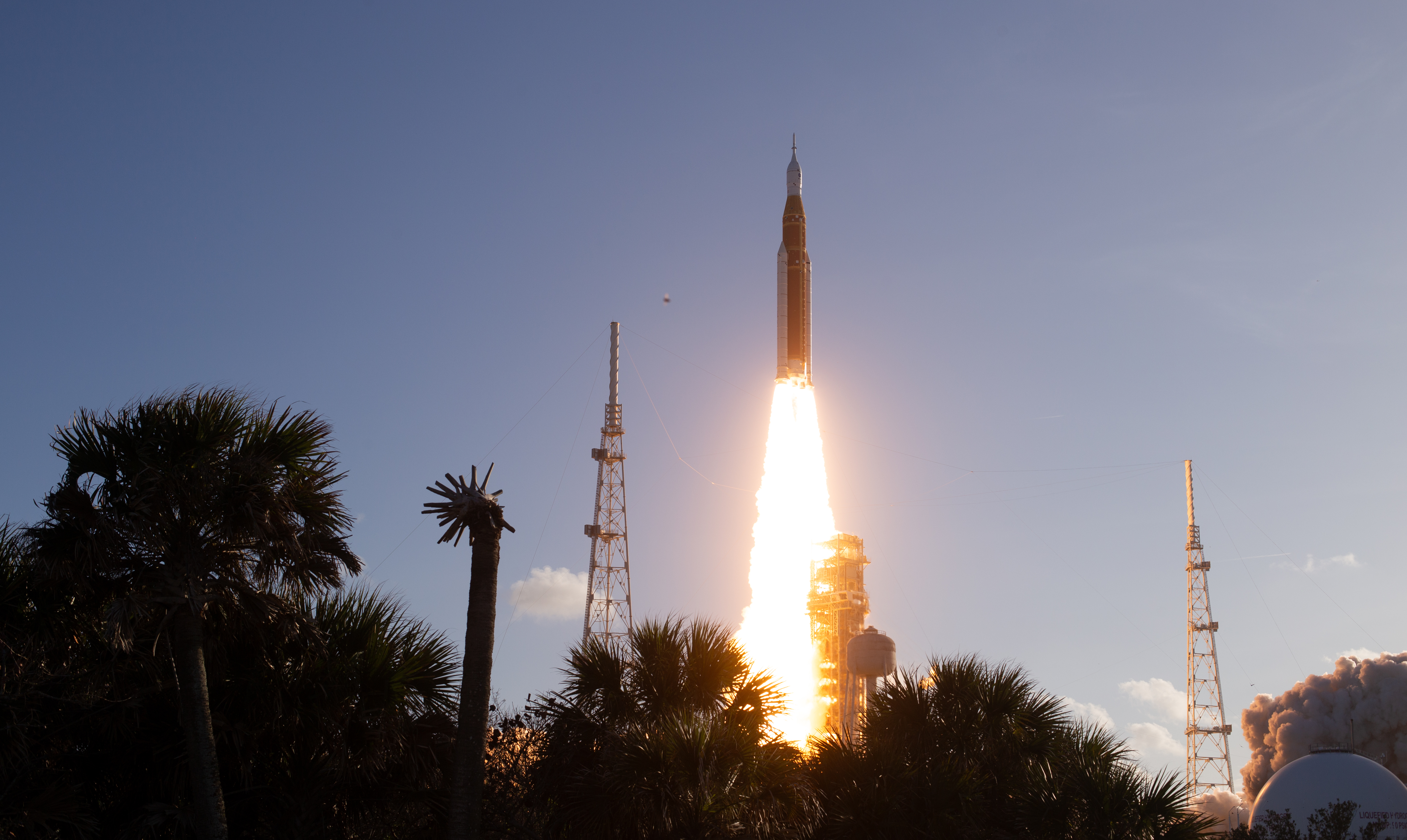
NASA’s SLS (Space Launch System) rocket and Orion spacecraft lifted off from Launch Pad 39B at the agency’s Kennedy Space Center in Florida at 6:35 p.m. EDT on April 1, sending the four astronauts on a planned 10-day test flight around the Moon and back.
After reaching space, Orion deployed its four solar array wings, enabling the spacecraft to receive energy from the Sun, while the crew and engineers on the ground immediately began transitioning the spacecraft from launch to flight operations to start checking out key systems.
About 49 minutes into the test flight, the SLS rocket’s upper stage fired to put Orion into an elliptical orbit around Earth. A second planned burn by the stage propelled Orion, which the crew named “Integrity,” into a high Earth orbit extending about 46,000 miles above the Earth for about 24 hours of system checkouts. After the burn, Orion separated from the stage, flying free on its own.
The crew then conducted a manual piloting demonstration to test Orion’s handling qualities using the ICPS (interim cryogenic propulsion stage) as a docking target.
At the conclusion of the demonstration, Orion executed an automated departure burn to safely back away from the ICPS, after which the stage performed its own disposal burn and re-entered Earth’s atmosphere over a remote region of the Pacific Ocean.
Prior to its re-entry, four small CubeSats were deployed from SLS rocket’s Orion stage adapter.
Other tasks completed so far include a transition to the Deep Space Network for communications, the crew becoming acclimated to the space environment, completing their first rest periods, performing the first flywheel exercise, restoring the spacecraft’s toilet to normal operations, and configuring the spacecraft for the translunar injection burn.
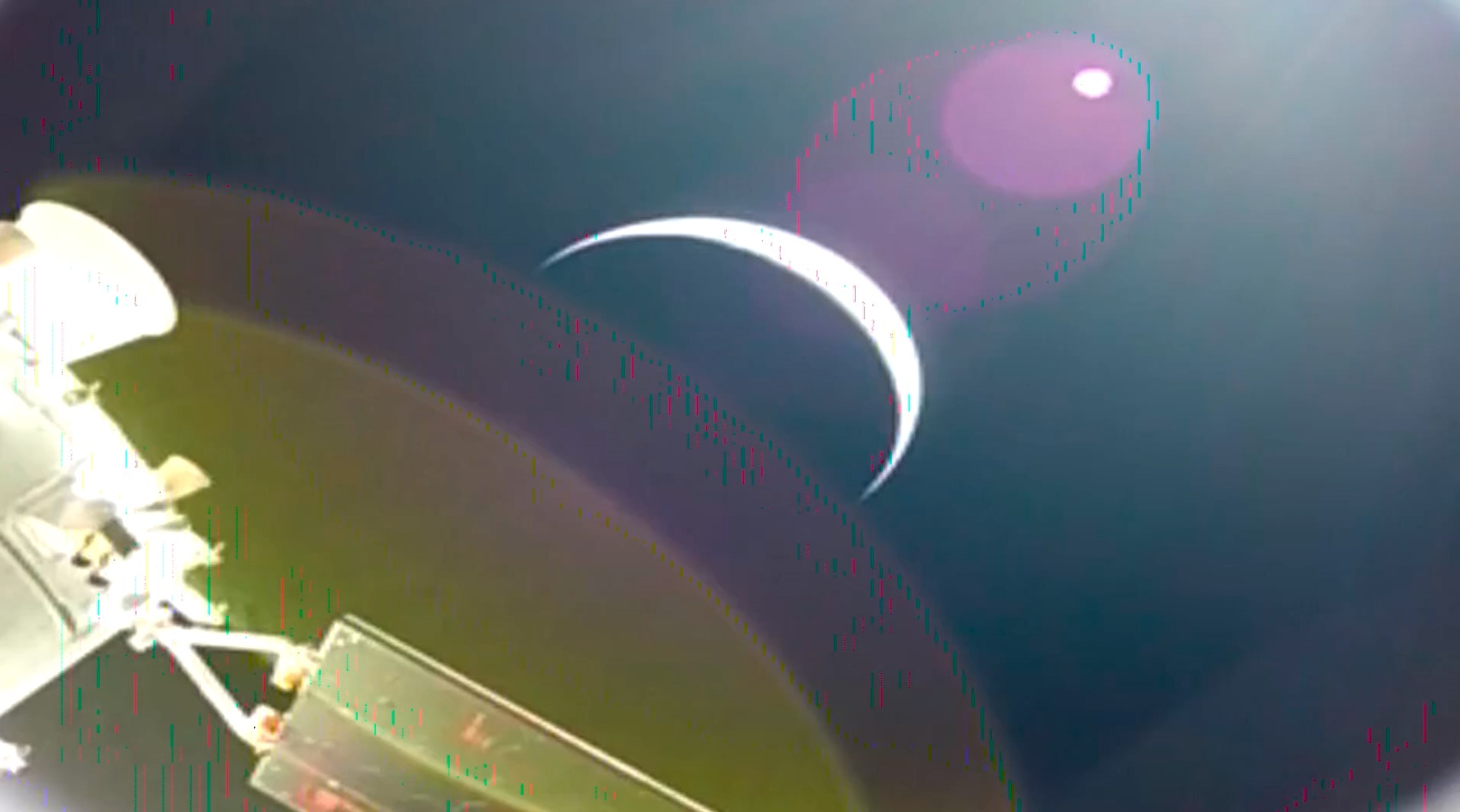
During a planned lunar flyby on Monday, April 6, the astronauts will take high resolution photographs and provide their own observations of the lunar surface, including areas of the far side of the Moon never seen directly by humans. Although the lunar far side will only be partially illuminated during the flyby, the conditions should create shadows that stretch across the surface, enhancing relief and revealing depth, ridges, slopes, and crater rims that are often difficult to detect under full illumination.
Following a successful lunar flyby, the astronauts will return to Earth and splash down in the Pacific Ocean off the coast of San Diego.
As part of a Golden Age of innovation and exploration, NASA will send Artemis astronauts on increasingly challenging missions to explore more of the Moon for scientific discovery, economic benefits, and to build on our foundation for the first crewed missions to Mars.
Follow the latest mission progress, including more images from the test flight, at:
https://www.nasa.gov/artemis-ii
-end-
Cheryl Warner / Rachel Kraft
Headquarters, Washington
202-358-1600
cheryl.m.warner@nasa.gov / rachel.h.kraft@nasa.gov
NASA’s Artemis II Mission Leaves Earth Orbit for Flight around Moon
For the first time in more than 50 years, astronauts on a NASA mission are bound to fly around the Moon after successfully completing a key burn of Orion’s main engine.
With the approximately six-minute firing of the spacecraft’s service module engine on Thursday, known as the translunar injection burn, Orion and its crew of NASA astronauts Reid Wiseman, Victor Glover, Christina Koch, and CSA (Canadian Space Agency) astronaut Jeremy Hansen accelerated to break free of Earth’s orbit and began the outbound trajectory toward Earth’s nearest neighbor.
“Today, for the first time since Apollo 17 in 1972, humans have departed Earth orbit. Reid, Victor, Christina, and Jeremy now are on a precise trajectory toward the Moon. Orion is operating with crew for the first time in space, and we are gathering critical data, and learning from each step,” said Dr. Lori Glaze, acting associate administrator for the Exploration Systems Development Mission Directorate at NASA Headquarters in Washington. “Each milestone we reach marks meaningful progress on the path forward for the Artemis program. While we have eight intensive days of work ahead, this is a big moment, and we’re proud to share it with the world.”
NASA’s SLS (Space Launch System) rocket and Orion spacecraft lifted off from Launch Pad 39B at the agency’s Kennedy Space Center in Florida at 6:35 p.m. EDT on April 1, sending the four astronauts on a planned 10-day test flight around the Moon and back.
After reaching space, Orion deployed its four solar array wings, enabling the spacecraft to receive energy from the Sun, while the crew and engineers on the ground immediately began transitioning the spacecraft from launch to flight operations to start checking out key systems.
About 49 minutes into the test flight, the SLS rocket’s upper stage fired to put Orion into an elliptical orbit around Earth. A second planned burn by the stage propelled Orion, which the crew named “Integrity,” into a high Earth orbit extending about 46,000 miles above the Earth for about 24 hours of system checkouts. After the burn, Orion separated from the stage, flying free on its own.
The crew then conducted a manual piloting demonstration to test Orion’s handling qualities using the ICPS (interim cryogenic propulsion stage) as a docking target.
At the conclusion of the demonstration, Orion executed an automated departure burn to safely back away from the ICPS, after which the stage performed its own disposal burn and re-entered Earth’s atmosphere over a remote region of the Pacific Ocean.
Prior to its re-entry, four small CubeSats were deployed from SLS rocket’s Orion stage adapter.
Other tasks completed so far include a transition to the Deep Space Network for communications, the crew becoming acclimated to the space environment, completing their first rest periods, performing the first flywheel exercise, restoring the spacecraft’s toilet to normal operations, and configuring the spacecraft for the translunar injection burn.
During a planned lunar flyby on Monday, April 6, the astronauts will take high resolution photographs and provide their own observations of the lunar surface, including areas of the far side of the Moon never seen directly by humans. Although the lunar far side will only be partially illuminated during the flyby, the conditions should create shadows that stretch across the surface, enhancing relief and revealing depth, ridges, slopes, and crater rims that are often difficult to detect under full illumination.
Following a successful lunar flyby, the astronauts will return to Earth and splash down in the Pacific Ocean off the coast of San Diego.
As part of a Golden Age of innovation and exploration, NASA will send Artemis astronauts on increasingly challenging missions to explore more of the Moon for scientific discovery, economic benefits, and to build on our foundation for the first crewed missions to Mars.
Follow the latest mission progress, including more images from the test flight, at:
https://www.nasa.gov/artemis-ii
-end-
Cheryl Warner / Rachel Kraft
Headquarters, Washington
202-358-1600
cheryl.m.warner@nasa.gov / rachel.h.kraft@nasa.gov
NASA’s Artemis II mission is officially on track for the moon
The Orion spacecraft just completed its last planned major fuel burn, setting its course for the rest of its 10-day journey around the moon and back
Why humpback whale rescue effort got called off
It was a tough decision to leave Timmy the humpback whale to die on a small island in the Baltic Sea
RFK, Jr., and EPA announce plan to track microplastics in tap water and humans
The Department of Health and Human Services and the Environmental Protection Agency announced a joint effort to track microplastics in drinking water—but experts say doing so will be difficult
Octopus sex is even weirder than you think
Scientists have learned how male octopuses’ specialized sperm-depositing arm knows where to go
How Eli Lilly’s new GLP‑1 pill stacks up against Wegovy and other weight‑loss drugs
This week the U.S. Food and Drug Administration approved a second GLP-1 pill for weight loss. The drug, called Foundayo, resulted in an average of 27 pounds lost in 72 weeks
‘Jaw-dropping’ fossils reset the clock on when complex animals evolved
A treasure trove of fossils from China shows that the Cambrian explosion may have been less explosive than scientists once believed
Artemis II Astronauts Launch to Moon
NASA’s Space Launch System rocket and Orion spacecraft lift off in this April 1, 2026, image. NASA’s Artemis II mission will take NASA astronauts Reid Wiseman, Victor Glover, and Christina Koch, and CSA (Canadian Space Agency) astronaut Jeremy on an approximately 10-day journey around the Moon and back aboard their Orion spacecraft.
Image credit: NASA/Aubrey Gemignani
Anthropic leak reveals Claude Code tracking user frustration and raises new questions about AI privacy
Code that reads your frustration is the least interesting part of the story of this accidental leak from Anthropic. The leak reveals how AI tools are also concealing their own role in the work they help produce
See these ziti-sized fish scale a 50-foot waterfall
These tiny fish use friction to put human rock climbers to shame