
Feed aggregator
Bizarre Ecosystem Discovered More Than Two Miles beneath Arctic Ocean
Dynamic mounds made of methane at a depth of some 3,640 meters act like “frozen reefs” for a bizarre array of deep-sea creatures, new observations reveal
The world’s first fully 3D-printed microscope blew up in 2025
The world’s first fully 3D-printed microscope blew up in 2025
How To Start with Your New Telescope
How to start sky exploring with that new telescope. How to set it up right, other key things to know -- and great cosmic immensities to start finding tonight.
The post How To Start with Your New Telescope appeared first on Sky & Telescope.
Physicists used 'dark photons' in an effort to rewrite physics in 2025
Physicists used 'dark photons' in an effort to rewrite physics in 2025
Santa Visits Artemis II Rocket
Santa Visits Artemis II Rocket
Santa Claus (NASA engineer Guy Naylor) poses with NASA’s Artemis II Orion spacecraft and SLS (Space Launch System) rocket in the Vehicle Assembly Building at NASA’s Kennedy Space Center in Florida on Dec. 11, 2025. The Orion spacecraft was stacked atop the SLS in October 2025.
Set to launch in early 2026, the Artemis II test flight will be NASA’s first mission with crew under Artemis. Astronauts on their first flight aboard Orion will confirm all the spacecraft’s systems operate as designed with crew aboard in the actual environment of deep space. Through the Artemis campaign, NASA will send astronauts to explore the Moon for scientific discovery, economic benefits, and to build the foundation for the first crewed missions to Mars – for the benefit of all.
Image credit: NASA/Adeline Morgan
Sparkling Galaxy Merger Shines in New Euclid Space Telescope Image
The Euclid Space Telescope is decking the halls with boughs of starlight
Our 7 Best Science TikToks You Need to Watch Right Now
On TikTok and other short-form video platforms, Scientific American explored the underground labs of Greenland, brand-new colors and the perfect way to make eggs
More than 100 moons were discovered in our own solar system in 2025
More than 100 moons were discovered in our own solar system in 2025
What Researchers Are Doing to Protect Christmas Trees in a Warming World
As Christmas trees face mounting challenges from climate change, researchers explore solutions to help ensure that a beloved holiday tradition endures in a warming world.
Tired of an Old-Fashioned Yule Log Video? Try These Scientific Alternatives Instead
Happy holidays from all of us at Scientific American
FCC Drone Ban—What the New ‘Covered List’ Means for DJI and Pilots
The U.S.’s decision to ban the sale of new foreign-made drones will have far wider-reaching implications than its effect on pilots’ ability to access new models and parts
OPERA: Addressing Societal Needs with Satellite Data
5 min read
OPERA: Addressing Societal Needs with Satellite DataIntroduction
The Observational Products for End-Users from Remote Sensing Analysis (OPERA) project represents a strategic initiative designed to address critical satellite data needs identified by federal agencies. Established in 2021 by the NASA/Jet Propulsion Laboratory (JPL), OPERA responds to priorities identified by the Satellite Needs Working Group (SNWG), an interagency body convened by the White House Office of Management and Budget (OMB) and Office of Science and Technology Policy (OSTP). SNWG surveys federal agencies every two years to determine their top satellite data needs. This article summarizes OPERA, including its mandate, and then presents a case study demonstrating how the United States Department of Agriculture (USDA) Agricultural Research Service (ARS) is using OPERA to monitor agricultural health in the Midwestern United States.
OPERA Mandate and Approach
The core mandate for the OPERA project lies in its commitment to delivering data products in formats that are immediately usable and analysis-ready. Rather than providing raw satellite data that requires extensive processing expertise, OPERA transforms complex satellite observations into standardized, accessible products that federal agencies can quickly integrate into their existing workflows to support national security, environmental monitoring, disaster response, and infrastructure management. This approach eliminates the technical barriers that often prevent agencies from effectively using satellite data, allowing them to focus on their mission-critical applications rather than data processing challenges.
To achieve this goal at the scale required by federal agencies, OPERA has developed a sophisticated cloud-based production system capable of generating data products efficiently and consistently to meet the dynamic needs of federal users. As of 2025, OPERA has successfully released dynamic surface water extent, surface disturbance, and surface displacement data through various NASA Distributed Active Archive Centers (DAACs). The vertical land motion product will be OPERA’s next offering beginning in 2028 – see Figure 1.
Figure 1. As of 2025, OPERA has successfully released dynamic surface water extent, surface disturbance, and surface displacement data products that are available through various NASA Distributed Active Archive Centers. The vertical land motion product will be OPERA’s next offering beginning in 2028. Figure credit: Clockwise starting from bottom left. Firth River Yukon, Water Data. Credit: USGS/John Jones, Lava boiling out of the Kilauea Volcano, Volcano Data. Credit: ASI/NASA/JPL-Caltech, Subsidence and uplift over New York City, Vertical Land Motion Data. Credit: NASA/JPL-Caltech, Fire fighting helicopter carry water bucket to extinguish the forest fire, Fire Data. Credit: Hansen/UMD/Google/USGS/NASA
OPERA Mission
OPERA delivers high-quality, ready-to-use satellite-derived information to enable federal agencies to better monitor environmental changes, respond to natural disasters, assess infrastructure risks, and make data-driven decisions. To illustrate this goal, OPERA’s 5th Annual Stakeholder Engagement Workshop detailed real-world applications of this approach on Sept. 11, 2025.
Case Study: Harnessing OPERA Data to Map Crop Health in Midwest United States
When water lingers on farmland, the consequences often ripple outward, resulting in crop losses, changes in soil health, and shifting carbon storage. In the rolling landscape of central Iowa’s South Fork watershed, these challenges are a daily reality for farmers, researchers, and crop insurance companies. To address these concerns, scientists at the U.S. Department of Agriculture–Agriculture Research Service’s (USDA–ARS) National Laboratory for Agriculture and the Environment (NLAE) are partnering with NASA’s OPERA project.
Using OPERA’s Dynamic Surface Water Extent (DSWx) and Surface Disturbance (DIST) product suites, USDA–NLAE researchers began the process of identifying depressions where water consistently ponds across fields – see Figure 2.
Figure 2. The map of maximum inundation combines individual Observational Products for End-Users from Remote Sensing Analysis (OPERA) Dynamic Surface Water Extent (DSWx) granules acquired over a month. Figure credit: NASA/JPL-Caltech, Dr. Renato Prata de Moraes Frasson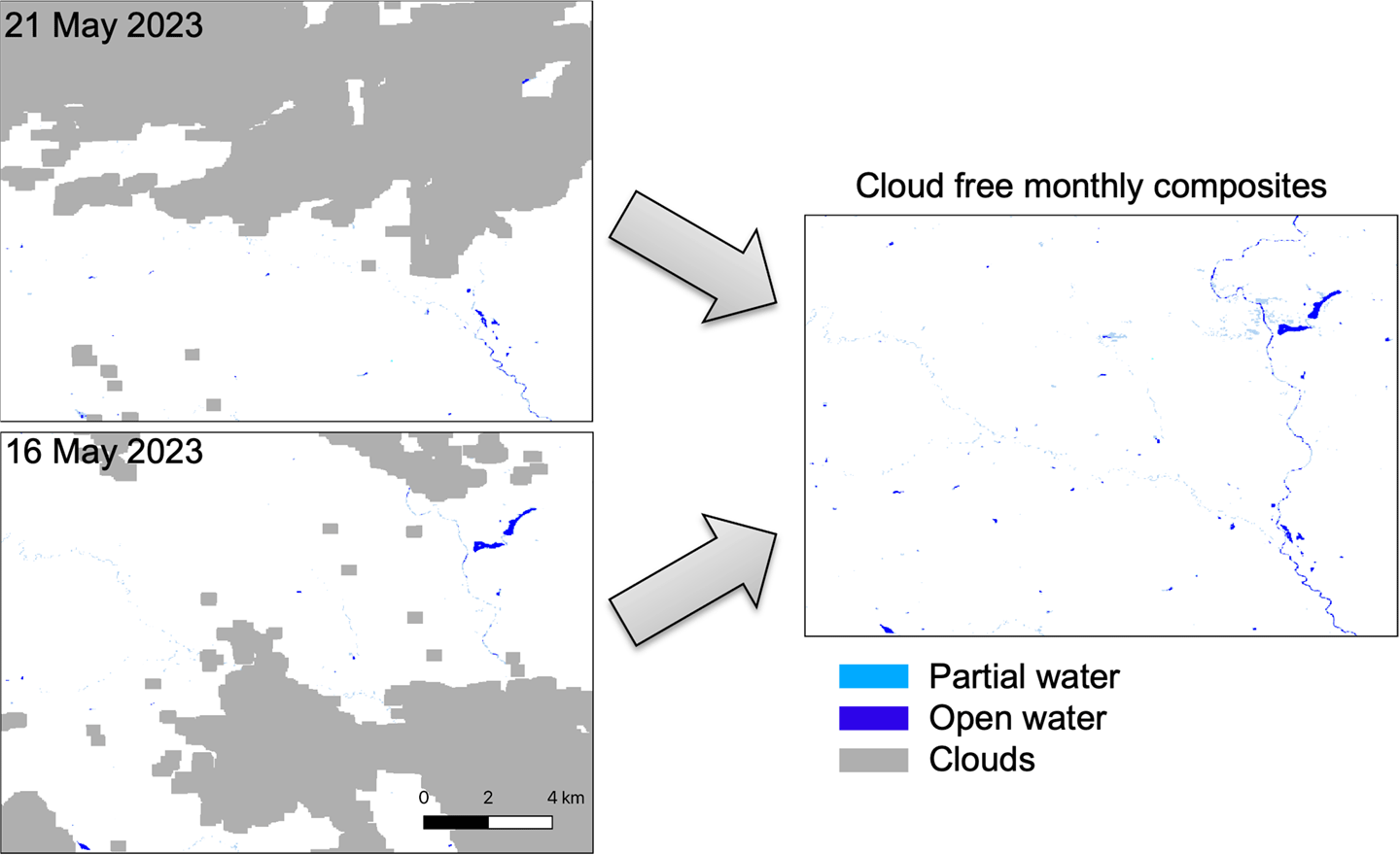
These sites are often more than nuisance puddles; they signal areas of reduced yield, risk for crop mortality, and hotspots for carbon and nutrient accumulation. By combining OPERA’s cloud-free, high-resolution mosaics with field-based measurements from USDA and university partners, the joint OPERA-NLAE team is producing actionable maps that pinpoint waterlogged zones – see Figure 3. Farmers can use these maps to improve soil health and guide land-management decisions.
Figure 3. The map depicts a field south of Iowa Falls in Hardin County, IA. The pixels are color-coded to indicate the number of times a region is inundated with water from May through October 2024. Larger numbers are associated with deeper depressions and with perennial lakes and rivers, including the Iowa River flowing west to east in the northern part of the image. Figure credit: NASA/JPL-Caltech, Dr. Renato Prata de Moraes Frasson
The OPERA products also support broader watershed management. Analyses of river migration, oxbow lake formation, and storm damage from powerful Midwestern derecho events show how OPERA data extend beyond field plots to larger areas. By detecting both persistent inundation and shifts in vegetation health, DSWx and DIST together provide synergistic information identifying areas where improved tile drainage may result in better crop health and increased yields. This approach can also be used to mitigate topsoil erosion and nutrient transport to control the development of harmful algal blooms and the occurrence of anoxic zones with implications far beyond the Mississippi Delta.
Conclusion
The use of OPERA data by USDA–ARS to map and monitor crop health in the Midwest United States highlights how this vital data product bridges the gap between Earth science and agricultural resilience. The outcome of this collaboration underscores OPERA’s mission – translating cutting-edge satellite observations into usable tools that support farmers, improve soil and water conservation, and strengthen the resilience of U.S. agriculture. This collaboration signifies the mandate of OPERA as an SNWG solution provider to fulfill the observation needs of federal users. All OPERA’s data products are freely available to the public from various NASA DAACs and are discoverable from the NASA Earthdata Search platform. The team welcomes direct engagement with individual federal, state, academic, and commercial stakeholders and can be reached via opera.sep@jpl.nasa.gov.
Steven K. Chan
Jet Propulsion Laboratory, California Institute of Technology
steven.k.chan@jpl.nasa.gov
Renato Prata de Moraes Frasson
Jet Propulsion Laboratory, California Institute of Technology
renato.prata.de.moraes.frasson@jpl.nasa.gov
Al Handwerger
Jet Propulsion Laboratory, California Institute of Technology
alexander.handwerger@jpl.nasa.gov
OPERA: Addressing Societal Needs with Satellite Data
5 min read
OPERA: Addressing Societal Needs with Satellite DataIntroduction
The Observational Products for End-Users from Remote Sensing Analysis (OPERA) project represents a strategic initiative designed to address critical satellite data needs identified by federal agencies. Established in 2021 by the NASA/Jet Propulsion Laboratory (JPL), OPERA responds to priorities identified by the Satellite Needs Working Group (SNWG), an interagency body convened by the White House Office of Management and Budget (OMB) and Office of Science and Technology Policy (OSTP). SNWG surveys federal agencies every two years to determine their top satellite data needs. This article summarizes OPERA, including its mandate, and then presents a case study demonstrating how the United States Department of Agriculture (USDA) Agricultural Research Service (ARS) is using OPERA to monitor agricultural health in the Midwestern United States.
OPERA Mandate and Approach
The core mandate for the OPERA project lies in its commitment to delivering data products in formats that are immediately usable and analysis-ready. Rather than providing raw satellite data that requires extensive processing expertise, OPERA transforms complex satellite observations into standardized, accessible products that federal agencies can quickly integrate into their existing workflows to support national security, environmental monitoring, disaster response, and infrastructure management. This approach eliminates the technical barriers that often prevent agencies from effectively using satellite data, allowing them to focus on their mission-critical applications rather than data processing challenges.
To achieve this goal at the scale required by federal agencies, OPERA has developed a sophisticated cloud-based production system capable of generating data products efficiently and consistently to meet the dynamic needs of federal users. As of 2025, OPERA has successfully released dynamic surface water extent, surface disturbance, and surface displacement data through various NASA Distributed Active Archive Centers (DAACs). The vertical land motion product will be OPERA’s next offering beginning in 2028 – see Figure 1.
Figure 1. As of 2025, OPERA has successfully released dynamic surface water extent, surface disturbance, and surface displacement data products that are available through various NASA Distributed Active Archive Centers. The vertical land motion product will be OPERA’s next offering beginning in 2028. Figure credit: Clockwise starting from bottom left. Firth River Yukon, Water Data. Credit: USGS/John Jones, Lava boiling out of the Kilauea Volcano, Volcano Data. Credit: ASI/NASA/JPL-Caltech, Subsidence and uplift over New York City, Vertical Land Motion Data. Credit: NASA/JPL-Caltech, Fire fighting helicopter carry water bucket to extinguish the forest fire, Fire Data. Credit: Hansen/UMD/Google/USGS/NASAOPERA Mission
OPERA delivers high-quality, ready-to-use satellite-derived information to enable federal agencies to better monitor environmental changes, respond to natural disasters, assess infrastructure risks, and make data-driven decisions. To illustrate this goal, OPERA’s 5th Annual Stakeholder Engagement Workshop detailed real-world applications of this approach on Sept. 11, 2025.
Case Study: Harnessing OPERA Data to Map Crop Health in Midwest United States
When water lingers on farmland, the consequences often ripple outward, resulting in crop losses, changes in soil health, and shifting carbon storage. In the rolling landscape of central Iowa’s South Fork watershed, these challenges are a daily reality for farmers, researchers, and crop insurance companies. To address these concerns, scientists at the U.S. Department of Agriculture–Agriculture Research Service’s (USDA–ARS) National Laboratory for Agriculture and the Environment (NLAE) are partnering with NASA’s OPERA project.
Using OPERA’s Dynamic Surface Water Extent (DSWx) and Surface Disturbance (DIST) product suites, USDA–NLAE researchers began the process of identifying depressions where water consistently ponds across fields – see Figure 2.
Figure 2. The map of maximum inundation combines individual Observational Products for End-Users from Remote Sensing Analysis (OPERA) Dynamic Surface Water Extent (DSWx) granules acquired over a month. Figure credit: NASA/JPL-Caltech, Dr. Renato Prata de Moraes FrassonThese sites are often more than nuisance puddles; they signal areas of reduced yield, risk for crop mortality, and hotspots for carbon and nutrient accumulation. By combining OPERA’s cloud-free, high-resolution mosaics with field-based measurements from USDA and university partners, the joint OPERA-NLAE team is producing actionable maps that pinpoint waterlogged zones – see Figure 3. Farmers can use these maps to improve soil health and guide land-management decisions.
Figure 3. The map depicts a field south of Iowa Falls in Hardin County, IA. The pixels are color-coded to indicate the number of times a region is inundated with water from May through October 2024. Larger numbers are associated with deeper depressions and with perennial lakes and rivers, including the Iowa River flowing west to east in the northern part of the image. Figure credit: NASA/JPL-Caltech, Dr. Renato Prata de Moraes FrassonThe OPERA products also support broader watershed management. Analyses of river migration, oxbow lake formation, and storm damage from powerful Midwestern derecho events show how OPERA data extend beyond field plots to larger areas. By detecting both persistent inundation and shifts in vegetation health, DSWx and DIST together provide synergistic information identifying areas where improved tile drainage may result in better crop health and increased yields. This approach can also be used to mitigate topsoil erosion and nutrient transport to control the development of harmful algal blooms and the occurrence of anoxic zones with implications far beyond the Mississippi Delta.
Conclusion
The use of OPERA data by USDA–ARS to map and monitor crop health in the Midwest United States highlights how this vital data product bridges the gap between Earth science and agricultural resilience. The outcome of this collaboration underscores OPERA’s mission – translating cutting-edge satellite observations into usable tools that support farmers, improve soil and water conservation, and strengthen the resilience of U.S. agriculture. This collaboration signifies the mandate of OPERA as an SNWG solution provider to fulfill the observation needs of federal users. All OPERA’s data products are freely available to the public from various NASA DAACs and are discoverable from the NASA Earthdata Search platform. The team welcomes direct engagement with individual federal, state, academic, and commercial stakeholders and can be reached via opera.sep@jpl.nasa.gov.
Steven K. Chan
Jet Propulsion Laboratory, California Institute of Technology
steven.k.chan@jpl.nasa.gov
Renato Prata de Moraes Frasson
Jet Propulsion Laboratory, California Institute of Technology
renato.prata.de.moraes.frasson@jpl.nasa.gov
Al Handwerger
Jet Propulsion Laboratory, California Institute of Technology
alexander.handwerger@jpl.nasa.gov
Get In, We’re Going Moonbound: Meet NASA’s Artemis Closeout Crew
For most, getting into a car is a task that can be done without assistance. Yet for those whose destination is the Moon, the process of getting inside and secured – in this case, in NASA’s Orion spacecraft – requires help. That’s the role of the Artemis closeout crew.
Trained to support Artemis II and future Moon missions, the five closeout crew members will be the last people to see NASA astronauts Reid Wiseman, Victor Glover, and Christina Koch, and CSA (Canadian Space Agency) astronaut Jeremy Hansen before their lunar journey.
The Artemis II closeout team consists of a lead, Taylor Hose; an astronaut support person, astronaut Andre Douglas; one technician specially trained on Orion crew survival system spacesuits, Bill Owens; and two Orion technicians, Christian Warriner and Ricky Ebaugh.
We are responsible for getting the astronauts strapped in their spacecraft, getting all their connections attached to their spacesuits, and then we close the hatch and close out Orion for launch.Taylor Hose
Artemis II Closeout Team Lead
Think of them like a pit crew for car races.
When the astronauts arrive on launch day at Launch Complex 39B at NASA’s Kennedy Space Center in Florida, the closeout crew will already be in place. First, the team will help the astronauts don their helmets and gloves before entering the Orion spacecraft.
Closeout Crew lead Taylor Hose, second from left, talks with NASA astronaut Andre Douglas, second from right as he and closeout crewmembers Will Sattler, left, and Christian Warriner prepare for the arrival of Artemis II crewmembers NASA astronauts Reid Wiseman, commander; Victor Glover, pilot; Christina Koch, mission specialist; and CSA (Canadian Space Agency) astronaut Jeremy Hansen, mission specialist; at the 275-foot level of the mobile launcher as they prepare to board their Orion spacecraft atop NASA’s Space Launch System rocket during the Artemis II countdown demonstration test, Saturday, Dec. 20, 2025, inside the Vehicle Assembly Building at NASA Kennedy. NASA/Joel Kowsky
Once inside, Owens and Douglas will assist each crew member with buckling up – except instead of using just one seatbelt like in a car, the crew needs several more intricate connections. Each seat includes five straps to secure the astronauts inside the crew module and several additional connections to the environmental control and life support systems and communications system aboard.
After the astronauts are secured, the hatch technicians will begin closing the spacecraft hatch. Unlike a car door that easily opens and closes with the pull of a handle, Orion’s hatch requires more effort to securely close.
“The hatch is pneumatically driven so we have to have air lines hooked up to it, and we need the help of the ground support system to close it,” said Hose.
Bill Owens of the Closeout Crew is seen as he leads Artemis II crewmembers CSA (Canadian Space Agency) astronaut Jeremy Hansen, mission specialist; and NASA astronauts Reid Wiseman, commander; Victor Glover, pilot; and Christina Koch, mission specialist; out of at the elevator towards the crew access arm at the 275-foot level of the mobile launcher as they prepare to board their Orion spacecraft atop NASA’s Space Launch System rocket during the Artemis II countdown demonstration test, Saturday, Dec. 20, 2025, inside the Vehicle Assembly Building at NASA Kennedy. NASA/Joel Kowsky
On launch day, it will take about four hours for the crew to get situated inside Orion and for the closeout process, including buttoning up both the crew module hatch and an exterior launch abort system hatch, to be complete. Even a single strand of hair inside the hatch doors could potentially pose issues with closing either hatch, so the process is carefully done.
“We have a lot of work to do with the seals alone – greasing, cleaning, taking the hatch cover off – and then we get into crew module hatch closure,” Hose said. “So after latching the hatch, we take window covers off, install thermal protection panels, and remove the purge barrier in between the vehicle and the ogive panels, which help protect the crew module during launch and ascent.”
The team then closes the launch abort system hatch and finishes final preparations before launch. Following the abort system hatch closure, the closeout crew departs the launch pad but stays nearby in case they need to return for any reason.
Taylor Hose prepares for the arrival of Artemis II crewmembers NASA astronauts Reid Wiseman, commander; Victor Glover, pilot; Christina Koch, mission specialist; and CSA (Canadian Space Agency) astronaut Jeremy Hansen, mission specialist; at the 275-foot level of the mobile launcher to board their Orion spacecraft atop NASA’s Space Launch System rocket during the Artemis II countdown demonstration test, Saturday, Dec. 20, 2025, inside the Vehicle Assembly Building at NASA Kennedy.NASA/Joel Kowsky My life goal was to be an astronaut. To help send people to the Moon for the first time since 1972 to not just go and visit, but this time to stay, I think that’s everything. That's our first steppingstone of going to Mars and expanding into the solar system.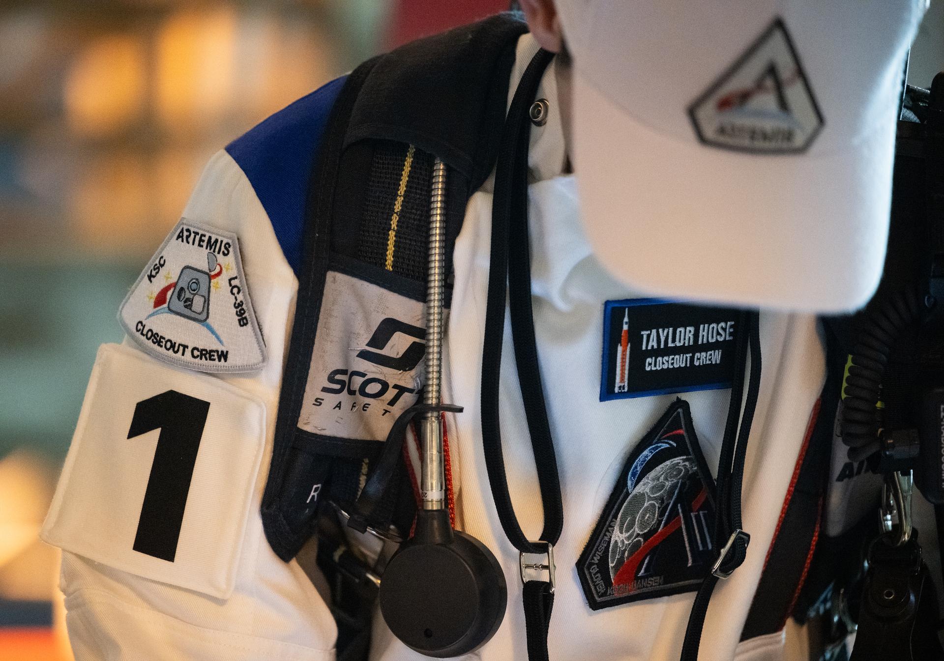
Taylor Hose
Artemis II Closeout Team Lead
After launch, several team members will head to San Diego, to help with post-splashdown efforts once the mission concludes.
As part of a Golden Age of innovation and exploration, the Artemis II test flight is the first crewed flight under NASA’s Artemis campaign. It is another step toward new U.S.-crewed missions on the Moon’s surface that will help the agency prepare to send the first astronauts – Americans – to Mars.
About the AuthorAntonia Jaramillo Share Details Last Updated Dec 23, 2025 Related Terms Explore More 4 min read Artemis II Flight Crew, Teams Conduct Demonstration Ahead of Launch Article 6 days ago 3 min read I Am Artemis: Grace Lauderdale Article 6 days ago 6 min read NASA Kennedy Top 20 Stories of 2025 Article 7 days ago Keep Exploring Discover More Topics From NASAMissions
Humans in Space
Climate Change
Solar System