
Feed aggregator
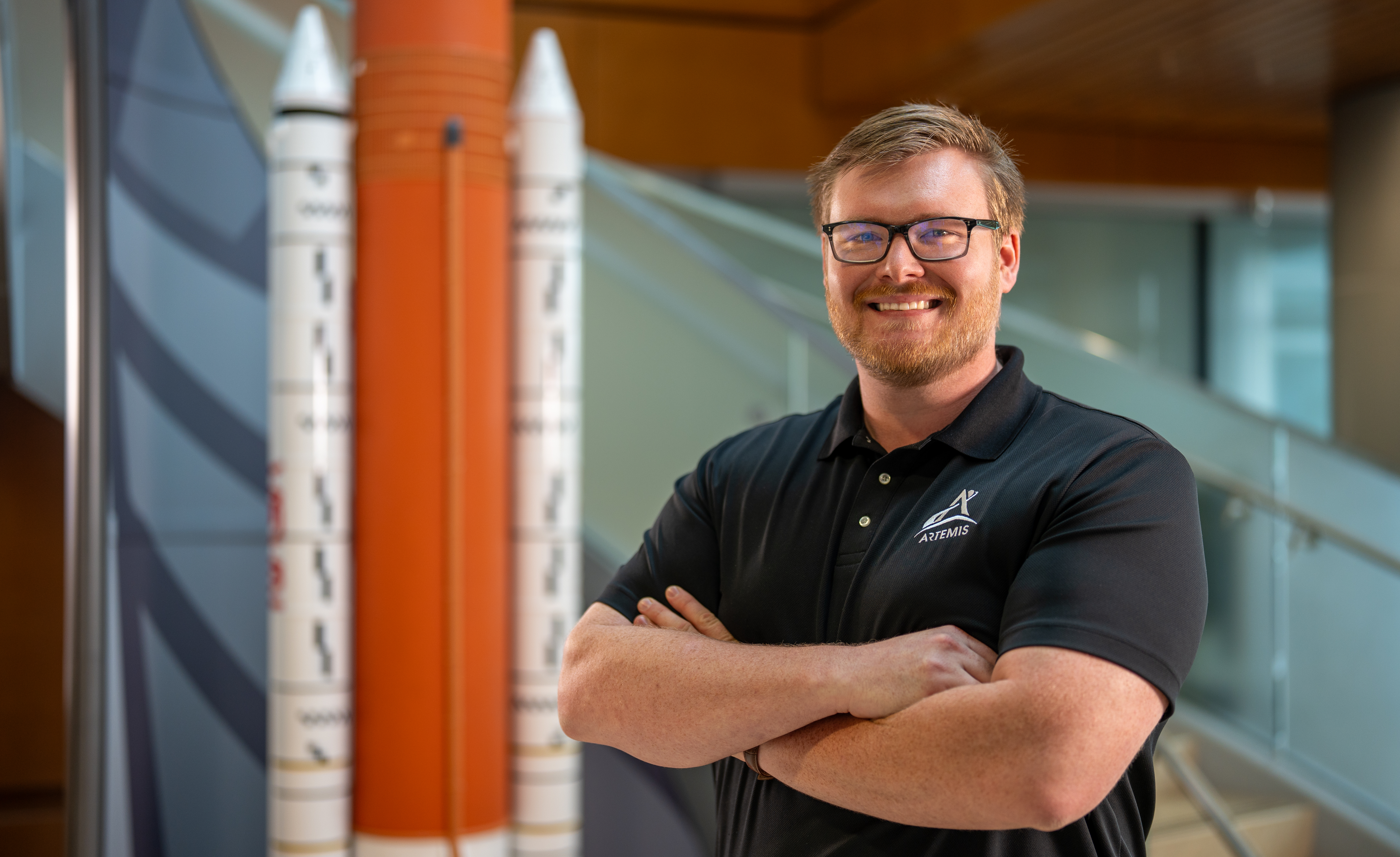
I Am Artemis: Patrick Junen
For some people, a passion for space is something that might develop over time, but for Patrick Junen, the desire was there from the beginning. With a father and grandfather who both worked for NASA, space exploration is not just a dream; it remains a family legacy.
Now, as the stage assembly and structures subsystem manager at NASA’s Marshall Space Flight Center in Huntsville, Alabama, for the BOLE (Booster Obsolescence Life Extension) Program — an advanced solid rocket booster for NASA’s SLS (Space Launch System) heavy lift rocket — Junen is continuing that legacy.
“My grandfather worked on the Apollo & Space Shuttle Programs. Then my dad went on to work for the Space Shuttle and SLS Programs,” Junen says. “I guess you could say engineering is in my blood.”
In his role, he’s responsible for managing the Design, Development, Test, & Evaluation team for all unpressurized structural elements, such as the forward skirt, aft skirt, and the integration hardware that connects the boosters to the core stage. He also collaborates closely with NASA’s Exploration Ground Systems at Kennedy Space Center in Florida to coordinate any necessary modifications to ground facilities or the mobile launcher to support the new boosters.
Junen enjoys the technical challenges of his role and said he feels fortunate to be in a position of leadership — but it takes a team of talented individuals to build the next generation of boosters. As a former offensive lineman for the University of Mississippi, he knows firsthand the power of teamwork and the importance of effective communication in guiding a coordinated effort.
“I’ve always been drawn to team activities, and exploration is the ultimate team endeavor,” Junen says. “On the football field, it takes a strong team to be successful — and it’s really no different from what we’re doing as a team at NASA with our Northrop Grumman counterparts for the SLS rocket and Artemis missions.”
As a kid, Junen often accompanied his dad to Space Shuttle launches and was inspired by some of the talented engineers that developed Shuttle. Years later, he’s still seeing some of those same faces — but now they’re teammates, working together toward a greater mission.
“Growing up around Marshall Space Flight Center in Huntsville, Alabama, there was always this strong sense of family and dedication to the Misson. And that has always resonated with me,” Junen recalls.
This philosophy of connecting family to the mission is a tradition Junen now continues with his own children. One of his fondest NASA memories is watching the successful launch of Artemis I on Nov. 16, 2022. Although he couldn’t attend in person, Junen and his family made the most of the moment — watching the launch live beneath the Saturn V rocket at Huntsville’s U.S. Space & Rocket Center. With his dad beside him and his daughter on his shoulders, three generations stood beneath the rocket Junen’s grandfather helped build, as a new era of space exploration began.
In June, Junen witnessed the BOLE Demonstration Motor-1 perform a full-scale static test to demonstrate the ballistic performance for the evolved booster motor. This test isn’t just a technical milestone for Junen — it’s a continuation of a lifelong journey rooted in family and teamwork.
As NASA explores the Moon and prepares for the journey to Mars through Artemis, Junen is helping shape the next chapter of human spaceflight. And just like the generations before him, he’s not only building rockets — he’s building a legacy.
News Media ContactJonathan Deal
Marshall Space Flight Center, Huntsville, Ala.
256-544-0034
jonathan.e.deal@nasa.gov
Ash trees are rapidly evolving some resistance to ash dieback disease
Ash trees are rapidly evolving some resistance to ash dieback disease
Deep sleep seems to lead to more eureka moments
Deep sleep seems to lead to more eureka moments
These rocks are probably the last remains of Earth's early crust
These rocks are probably the last remains of Earth's early crust
These Actions Could Make Vaccines Safer. But RFK, Jr., Isn’t Pursuing Them
Vaccines are safe, but they could always be safer—here’s what would make a difference
Star Trek: Strange New Worlds Season 3: Release date, cast & how to watch Paramount+'s summer sci-fi series
Sparkling Andromeda
Sparkling Andromeda
The Andromeda galaxy, also known as Messier 31 (M31), is a glittering beacon in this image released on June 25, 2025, in tribute to the groundbreaking legacy of astronomer Dr. Vera Rubin, whose observations transformed our understanding of the universe. In the 1960s, Rubin and her colleagues studied M31 and determined that there was some unseen matter in the galaxy that was affecting how the galaxy and its spiral arms rotated. This unknown material was named “dark matter.”
M31 is the closest spiral galaxy to the Milky Way at a distance of about 2.5 million light-years. Astronomers use Andromeda to understand the structure and evolution of our own spiral, which is much harder to do since Earth is embedded inside the Milky Way.
Learn more about this image and experience in sound, too.
Image credit: X-ray: NASA/CXO/UMass/Z. Li & Q.D. Wang, ESA/XMM-Newton; Infrared: NASA/JPL-Caltech/WISE, Spitzer, NASA/JPL-Caltech/K. Gordon (U. Az), ESA/Herschel, ESA/Planck, NASA/IRAS, NASA/COBE; Radio: NSF/GBT/WSRT/IRAM/C. Clark (STScI); Ultraviolet: NASA/JPL-Caltech/GALEX; Optical: Andromeda, Unexpected © Marcel Drechsler, Xavier Strottner, Yann Sainty & J. Sahner, T. Kottary. Composite image processing: L. Frattare, K. Arcand, J.Major
Human remains lost after memorial spaceflight capsule crashes into the sea
See a vivid green fireball light up the northeastern US (video)
By Air and by Sea: Validating NASA’s PACE Ocean Color Instrument
6 min read
Preparations for Next Moonwalk Simulations Underway (and Underwater) NASA Ames research scientist Kristina Pistone monitors instrument data while onboard the Twin Otter aircraft, flying over Monterey Bay during the October 2024 deployment of the AirSHARP campaign. NASA/Samuel Leblanc
In autumn 2024, California’s Monterey Bay experienced an outsized phytoplankton bloom that attracted fish, dolphins, whales, seabirds, and – for a few weeks in October – scientists. A team from NASA’s Ames Research Center in Silicon Valley, with partners at the University of California, Santa Cruz (UCSC), and the Naval Postgraduate School, spent two weeks on the California coast gathering data on the atmosphere and the ocean to verify what satellites see from above. In spring 2025, the team returned to gather data under different environmental conditions.
Scientists call this process validation.
Setting up the CampaignThe PACE mission, which stands for Plankton, Aerosol, Cloud, ocean Ecosystem, was launched in February 2024 and designed to transform our understanding of ocean and atmospheric environments. Specifically, the satellite will give scientists a finely detailed look at life near the ocean surface and the composition and abundance of aerosol particles in the atmosphere.
Whenever NASA launches a new satellite, it sends validation science teams around the world to confirm that the data from instruments in space match what traditional instruments can see at the surface. AirSHARP (Airborne aSsessment of Hyperspectral Aerosol optical depth and water-leaving Reflectance Product Performance for PACE) is one of these teams, specifically deployed to validate products from the satellite’s Ocean Color Instrument (OCI).
The OCI spectrometer works by measuring reflected sunlight. As sunlight bounces off of the ocean’s surface, it creates specific shades of color that researchers use to determine what is in the water column below. To validate the OCI data, research teams need to confirm that measurements directly at the surface match those from the satellite. They also need to understand how the atmosphere is changing the color of the ocean as the reflected light is traveling back to the satellite.
In October 2024 and May 2025, the AirSHARP team ran simultaneous airborne and seaborne campaigns. Going into the field during different seasons allows the team to collect data under different environmental conditions, validating as much of the instrument’s range as possible.
Over 13 days of flights on a Twin Otter aircraft, the NASA-led team used instruments called 4STAR-B (Spectrometer for sky-scanning sun Tracking Atmospheric Research B), and the C-AIR (Coastal Airborne In-situ Radiometer) to gather data from the air. At the same time, partners from UCSC used a host of matching instruments onboard the research vessel R/V Shana Rae to gather data from the water’s surface.
Ocean Color and Water Leaving ReflectanceThe Ocean Color Instrument measures something called water leaving reflectance, which provides information on the microscopic composition of the water column, including water molecules, phytoplankton, and particulates like sand, inorganic materials, and even bubbles. Ocean color varies based on how these materials absorb and scatter sunlight. This is especially useful for determining the abundance and types of phytoplankton.
Photographs taken out the window of the Twin Otter aircraft during the October 2024 AirSHARP deployment showcase the variation in ocean color, which indicates different molecular composition of the water column beneath. The red color in several of these photos is due to a phytoplankton bloom – in this case a growth of red algae. NASA/Samuel Leblanc
The AirSHARP team used radiometers with matching technology – C-AIR from the air and C-OPS (Compact Optical Profiling System) from the water – to gather water leaving reflectance data.
“The C-AIR instrument is modified from an instrument that goes on research vessels and takes measurements of the water’s surface from very close range,” said NASA Ames research scientist Samuel LeBlanc. “The issue there is that you’re very local to one area at a time. What our team has done successfully is put it on an aircraft, which enables us to span the entire Monterey Bay.”
The larger PACE validation team will compare OCI measurements with observations made by the sensors much closer to the ocean to ensure that they match, and make adjustments when they don’t.
Aerosol InterferenceOne factor that can impact OCI data is the presence of manmade and natural aerosols, which interact with sunlight as it moves through the atmosphere. An aerosol refers to any solid or liquid suspended in the air, such as smoke from fires, salt from sea spray, particulates from fossil fuel emissions, desert dust, and pollen.
Imagine a 420 mile-long tube, with the PACE satellite at one end and the ocean at the other. Everything inside the tube is what scientists refer to as the atmospheric column, and it is full of tiny particulates that interact with sunlight. Scientists quantify this aerosol interaction with a measurement called aerosol optical depth.
“During AirSHARP, we were essentially measuring, at different wavelengths, how light is changed by the particles present in the atmosphere,” said NASA Ames research scientist Kristina Pistone. “The aerosol optical depth is a measure of light extinction, or how much light is either scattered away or absorbed by aerosol particulates.”
The team measured aerosol optical depth using the 4STAR-B spectrometer, which was engineered at NASA Ames and enables scientists to identify which aerosols are present and how they interact with sunlight.
Twin Otter Aircraft AirSHARP principal investigator Liane Guild walks towards a Twin Otter aircraft owned and operated by the Naval Postgraduate School. The aircraft’s ability to perform complex, low-altitude flights made it the ideal platform to fly multiple instruments over Monterey Bay during the AirSHARP campaign. NASA/Samuel Leblanc
Flying these instruments required use of a Twin Otter plane, operated by the Naval Postgraduate School (NPS). The Twin Otter is unique for its ability to perform extremely low-altitude flights, making passes down to 100 feet above the water in clear conditions.
“It’s an intense way to fly. At that low height, the pilots continually watch for and avoid birds, tall ships, and even wildlife like breaching whales,” said Anthony Bucholtz, director of the Airborne Research Facility at NPS.
With the phytoplankton bloom attracting so much wildlife in a bay already full of ships, this is no small feat. “The pilots keep a close eye on the radar, and fly by hand,” Bucholtz said, “all while following careful flight plans crisscrossing Monterey Bay and performing tight spirals over the Research Vessel Shana Rae.”
Campaign DataData gathered from the 2024 phase of this campaign is available on two data archive systems. Data from the 4STAR instrument is available in the PACE data archive and data from C-AIR is housed in the SeaBASS data archive.
Other data from the NASA PACE Validation Science Team is available through the PACE website: https://pace.oceansciences.org/pvstdoi.htm#
Samuel LeBlanc and Kristina Pistone are funded via the Bay Area Environmental Research Institute (BAERI), which is a scientist-founded nonprofit focused on supporting Earth and space sciences.
About the AuthorMilan LoiaconoScience Communication SpecialistMilan Loiacono is a science communication specialist for the Earth Science Division at NASA Ames Research Center.
Share Details Last Updated Jun 26, 2025 Related Terms Explore More 2 min read NASA Citizen Scientists Find New Eclipsing Binary StarsWhen two stars orbit one another in such a way that one blocks the other’s…
Article 3 days ago 4 min read NASA-Assisted Scientists Get Bird’s-Eye View of Population StatusNASA satellite data and citizen science observations combine for new findings on bird populations.
Article 4 days ago 2 min read Live or Fly a Plane in California? Help NASA Measure Ozone Pollution!Ozone high in the stratosphere protects us from the Sun’s ultraviolet light. But ozone near…
Article 5 days agoBy Air and by Sea: Validating NASA’s PACE Ocean Color Instrument
6 min read
Preparations for Next Moonwalk Simulations Underway (and Underwater) NASA Ames research scientist Kristina Pistone monitors instrument data while onboard the Twin Otter aircraft, flying over Monterey Bay during the October 2024 deployment of the AirSHARP campaign. NASA/Samuel LeblancIn autumn 2024, California’s Monterey Bay experienced an outsized phytoplankton bloom that attracted fish, dolphins, whales, seabirds, and – for a few weeks in October – scientists. A team from NASA’s Ames Research Center in Silicon Valley, with partners at the University of California, Santa Cruz (UCSC), and the Naval Postgraduate School, spent two weeks on the California coast gathering data on the atmosphere and the ocean to verify what satellites see from above. In spring 2025, the team returned to gather data under different environmental conditions.
Scientists call this process validation.
Setting up the CampaignThe PACE mission, which stands for Plankton, Aerosol, Cloud, ocean Ecosystem, was launched in February 2024 and designed to transform our understanding of ocean and atmospheric environments. Specifically, the satellite will give scientists a finely detailed look at life near the ocean surface and the composition and abundance of aerosol particles in the atmosphere.
Whenever NASA launches a new satellite, it sends validation science teams around the world to confirm that the data from instruments in space match what traditional instruments can see at the surface. AirSHARP (Airborne aSsessment of Hyperspectral Aerosol optical depth and water-leaving Reflectance Product Performance for PACE) is one of these teams, specifically deployed to validate products from the satellite’s Ocean Color Instrument (OCI).
The OCI spectrometer works by measuring reflected sunlight. As sunlight bounces off of the ocean’s surface, it creates specific shades of color that researchers use to determine what is in the water column below. To validate the OCI data, research teams need to confirm that measurements directly at the surface match those from the satellite. They also need to understand how the atmosphere is changing the color of the ocean as the reflected light is traveling back to the satellite.
In October 2024 and May 2025, the AirSHARP team ran simultaneous airborne and seaborne campaigns. Going into the field during different seasons allows the team to collect data under different environmental conditions, validating as much of the instrument’s range as possible.
Over 13 days of flights on a Twin Otter aircraft, the NASA-led team used instruments called 4STAR-B (Spectrometer for sky-scanning sun Tracking Atmospheric Research B), and the C-AIR (Coastal Airborne In-situ Radiometer) to gather data from the air. At the same time, partners from UCSC used a host of matching instruments onboard the research vessel R/V Shana Rae to gather data from the water’s surface.
Ocean Color and Water Leaving ReflectanceThe Ocean Color Instrument measures something called water leaving reflectance, which provides information on the microscopic composition of the water column, including water molecules, phytoplankton, and particulates like sand, inorganic materials, and even bubbles. Ocean color varies based on how these materials absorb and scatter sunlight. This is especially useful for determining the abundance and types of phytoplankton.
Photographs taken out the window of the Twin Otter aircraft during the October 2024 AirSHARP deployment showcase the variation in ocean color, which indicates different molecular composition of the water column beneath. The red color in several of these photos is due to a phytoplankton bloom – in this case a growth of red algae. NASA/Samuel LeblancThe AirSHARP team used radiometers with matching technology – C-AIR from the air and C-OPS (Compact Optical Profiling System) from the water – to gather water leaving reflectance data.
“The C-AIR instrument is modified from an instrument that goes on research vessels and takes measurements of the water’s surface from very close range,” said NASA Ames research scientist Samuel LeBlanc. “The issue there is that you’re very local to one area at a time. What our team has done successfully is put it on an aircraft, which enables us to span the entire Monterey Bay.”
The larger PACE validation team will compare OCI measurements with observations made by the sensors much closer to the ocean to ensure that they match, and make adjustments when they don’t.
Aerosol InterferenceOne factor that can impact OCI data is the presence of manmade and natural aerosols, which interact with sunlight as it moves through the atmosphere. An aerosol refers to any solid or liquid suspended in the air, such as smoke from fires, salt from sea spray, particulates from fossil fuel emissions, desert dust, and pollen.
Imagine a 420 mile-long tube, with the PACE satellite at one end and the ocean at the other. Everything inside the tube is what scientists refer to as the atmospheric column, and it is full of tiny particulates that interact with sunlight. Scientists quantify this aerosol interaction with a measurement called aerosol optical depth.
“During AirSHARP, we were essentially measuring, at different wavelengths, how light is changed by the particles present in the atmosphere,” said NASA Ames research scientist Kristina Pistone. “The aerosol optical depth is a measure of light extinction, or how much light is either scattered away or absorbed by aerosol particulates.”
The team measured aerosol optical depth using the 4STAR-B spectrometer, which was engineered at NASA Ames and enables scientists to identify which aerosols are present and how they interact with sunlight.
Twin Otter Aircraft AirSHARP principal investigator Liane Guild walks towards a Twin Otter aircraft owned and operated by the Naval Postgraduate School. The aircraft’s ability to perform complex, low-altitude flights made it the ideal platform to fly multiple instruments over Monterey Bay during the AirSHARP campaign. NASA/Samuel LeblancFlying these instruments required use of a Twin Otter plane, operated by the Naval Postgraduate School (NPS). The Twin Otter is unique for its ability to perform extremely low-altitude flights, making passes down to 100 feet above the water in clear conditions.
“It’s an intense way to fly. At that low height, the pilots continually watch for and avoid birds, tall ships, and even wildlife like breaching whales,” said Anthony Bucholtz, director of the Airborne Research Facility at NPS.
With the phytoplankton bloom attracting so much wildlife in a bay already full of ships, this is no small feat. “The pilots keep a close eye on the radar, and fly by hand,” Bucholtz said, “all while following careful flight plans crisscrossing Monterey Bay and performing tight spirals over the Research Vessel Shana Rae.”
Campaign DataData gathered from the 2024 phase of this campaign is available on two data archive systems. Data from the 4STAR instrument is available in the PACE data archive and data from C-AIR is housed in the SeaBASS data archive.
Other data from the NASA PACE Validation Science Team is available through the PACE website: https://pace.oceansciences.org/pvstdoi.htm#
Samuel LeBlanc and Kristina Pistone are funded via the Bay Area Environmental Research Institute (BAERI), which is a scientist-founded nonprofit focused on supporting Earth and space sciences.
About the AuthorMilan LoiaconoScience Communication SpecialistMilan Loiacono is a science communication specialist for the Earth Science Division at NASA Ames Research Center.
Share Details Last Updated Jun 26, 2025 Related Terms Explore More 2 min read NASA Citizen Scientists Find New Eclipsing Binary StarsWhen two stars orbit one another in such a way that one blocks the other’s…
Article 4 days ago 4 min read NASA-Assisted Scientists Get Bird’s-Eye View of Population StatusNASA satellite data and citizen science observations combine for new findings on bird populations.
Article 5 days ago 2 min read Live or Fly a Plane in California? Help NASA Measure Ozone Pollution!Ozone high in the stratosphere protects us from the Sun’s ultraviolet light. But ozone near…
Article 6 days agoA Gigantic Megacomet Is Erupting as It Zooms through the Solar System
Recent observations have revealed carbon monoxide venting from the largest comet ever seen, providing clues about its origins in the mysterious depths of the outer solar system
NASA Mars Orbiter Learns New Moves After Nearly 20 Years in Space
6 min read
Preparations for Next Moonwalk Simulations Underway (and Underwater) An antenna sticks out like whiskers from NASA’s Mars Reconnaissance Orbiter in this artist’s concept of the spacecraft, which has been orbiting the Red Planet since 2006. This antenna is part of SHARAD, a radar that peers below the Martian surface.NASA/JPL-Caltech
The Mars Reconnaissance Orbiter is testing a series of large spacecraft rolls that will help it hunt for water.
After nearly 20 years of operations, NASA’s Mars Reconnaissance Orbiter (MRO) is on a roll, performing a new maneuver to squeeze even more science out of the busy spacecraft as it circles the Red Planet. Engineers have essentially taught the probe to roll over so that it’s nearly upside down. Doing so enables MRO to look deeper underground as it searches for liquid and frozen water, among other things.
The new capability is detailed in a paper recently published in the Planetary Science Journal documenting three “very large rolls,” as the mission calls them, that were performed between 2023 and 2024.
“Not only can you teach an old spacecraft new tricks, you can open up entirely new regions of the subsurface to explore by doing so,” said one of the paper’s authors, Gareth Morgan of the Planetary Science Institute in Tucson, Arizona.
To view this video please enable JavaScript, and consider upgrading to a web browser that supports HTML5 video
This animation depicts NASA’s Mars Reconnaissance Orbiter performing a 120-degree roll that increases the strength of its radar signal by 10 times or more.NASA/JPL-CaltechThe orbiter was originally designed to roll up to 30 degrees in any direction so that it can point its instruments at surface targets, including potential landing sites, impact craters, and more.
“We’re unique in that the entire spacecraft and its software are designed to let us roll all the time,” said Reid Thomas, MRO’s project manager at NASA’s Jet Propulsion Laboratory in Southern California.
The process for rolling isn’t simple. The spacecraft carries five operating science instruments that have different pointing requirements. To target a precise spot on the surface with one instrument, the orbiter has to roll a particular way, which means the other instruments may have a less-favorable view of Mars during the maneuver.
That’s why each regular roll is planned weeks in advance, with instrument teams negotiating who conducts science and when. Then, an algorithm checks MRO’s position above Mars and automatically commands the orbiter to roll so the appropriate instrument points at the correct spot on the surface. At the same time, the algorithm commands the spacecraft’s solar arrays to rotate and track the Sun and its high-gain antenna to track Earth to maintain power and communications.
Very large rolls, which are 120 degrees, require even more planning to maintain the safety of the spacecraft. The payoff is that the new maneuver enables one particular instrument, called the Shallow Radar (SHARAD), to have a deeper view of Mars than ever before.
SHARAD’s View of Mars During a ‘Very Large Roll’ CurtainToggle2-Up Image Details These two radargrams from the SHARAD instrument on NASA’s MRO reveal how the spacecraft’s new “very large roll” maneuver produces a stronger signal, providing a brighter, clearer picture of the Martian subsurface. Use the slider to compare the 120-degree roll, left, to the standard 28-degree roll. NASA/JPL-Caltech/University of Rome/ASI/PSI Bigger Rolls, Better ScienceDesigned to peer from about half a mile to a little over a mile (1 to 2 kilometers) belowground, SHARAD allows scientists to distinguish between materials like rock, sand, and ice. The radar was especially useful in determining where ice could be found close enough to the surface that future astronauts might one day be able to access it. Ice will be key for producing rocket propellant for the trip home and is important for learning more about the climate, geology, and potential for life at Mars.
But as great as SHARAD is, the team knew it could be even better.
To give cameras like the High-Resolution Imaging Science Experiment (HiRISE) prime viewing at the front of MRO, SHARAD’s two antenna segments were mounted at the back of the orbiter. While this setup helps the cameras, it also means that radio signals SHARAD pings onto the surface below encounter parts of the spacecraft, interfering with the signals and resulting in images that are less clear.
“The SHARAD instrument was designed for the near-subsurface, and there are select regions of Mars that are just out of reach for us,” said Morgan, a co-investigator on the SHARAD team. “There is a lot to be gained by taking a closer look at those regions.”
In 2023, the team decided to try developing 120-degree very large rolls to provide the radio waves an unobstructed path to the surface. What they found is that the maneuver can strengthen the radar signal by 10 times or more, offering a much clearer picture of the Martian underground.
But the roll is so large that the spacecraft’s communications antenna is not pointed at Earth, and its solar arrays aren’t able to track the Sun.
“The very large rolls require a special analysis to make sure we’ll have enough power in our batteries to safely do the roll,” Thomas said.
Given the time involved, the mission limits itself to one or two very large rolls a year. But engineers hope to use them more often by streamlining the process.
Learning to Roll With ItWhile SHARAD scientists are benefiting from these new moves, the team working with another MRO instrument, the Mars Climate Sounder, is making the most of MRO’s standard roll capability.
The JPL-built instrument is a radiometer that serves as one of the most detailed sources available of information on Mars’ atmosphere. Measuring subtle changes in temperature over the course of many seasons, Mars Climate Sounder reveals the inner workings of dust storms and cloud formation. Dust and wind are important to understand: They are constantly reshaping the Martian surface, with wind-borne dust blanketing solar panels and posing a health risk for future astronauts.
Mars Climate Sounder was designed to pivot on a gimbal so that it can get views of the Martian horizon and surface. It also provides views of space, which scientists use to calibrate the instrument. But in 2024, the aging gimbal became unreliable. Now Mars Climate Sounder relies on MRO’s standard rolls.
“Rolling used to restrict our science,” said Mars Climate Sounder’s interim principal investigator, Armin Kleinboehl of JPL, “but we’ve incorporated it into our routine planning, both for surface views and calibration.”
More About MRONASA’s Jet Propulsion Laboratory in Southern California manages MRO for the agency’s Science Mission Directorate in Washington as part of its Mars Exploration Program portfolio. The SHARAD instrument was provided by the Italian Space Agency. Its operations are led by Sapienza University of Rome, and its data is analyzed by a joint U.S.-Italian science team. The Planetary Science Institute in Tucson, Arizona, leads U.S. involvement in SHARAD. Lockheed Martin Space in Denver built MRO and supports its operations.
For more information, visit:
science.nasa.gov/mission/mars-reconnaissance-orbiter
News Media ContactsAndrew Good
Jet Propulsion Laboratory, Pasadena, Calif.
818-393-2433
andrew.c.good@jpl.nasa.gov
Karen Fox / Molly Wasser
NASA Headquarters, Washington
202-358-1600
karen.c.fox@nasa.gov / molly.l.wasser@nasa.gov
2025-084
Share Details Last Updated Jun 26, 2025 Related Terms Explore More 6 min read John Casani, Former Manager of Multiple NASA Missions, Dies Article 4 days ago 6 min read NASA’s Perseverance Rover Scours Mars for Science Article 4 days ago 5 min read NASA’s Curiosity Mars Rover Starts Unpacking Boxwork Formations Article 6 days ago Keep Exploring Discover Related TopicsMissions
Humans in Space
Climate Change
Solar System
NASA Mars Orbiter Learns New Moves After Nearly 20 Years in Space
6 min read
Preparations for Next Moonwalk Simulations Underway (and Underwater) An antenna sticks out like whiskers from NASA’s Mars Reconnaissance Orbiter in this artist’s concept of the spacecraft, which has been orbiting the Red Planet since 2006. This antenna is part of SHARAD, a radar that peers below the Martian surface.NASA/JPL-CaltechThe Mars Reconnaissance Orbiter is testing a series of large spacecraft rolls that will help it hunt for water.
After nearly 20 years of operations, NASA’s Mars Reconnaissance Orbiter (MRO) is on a roll, performing a new maneuver to squeeze even more science out of the busy spacecraft as it circles the Red Planet. Engineers have essentially taught the probe to roll over so that it’s nearly upside down. Doing so enables MRO to look deeper underground as it searches for liquid and frozen water, among other things.
The new capability is detailed in a paper recently published in the Planetary Science Journal documenting three “very large rolls,” as the mission calls them, that were performed between 2023 and 2024.
“Not only can you teach an old spacecraft new tricks, you can open up entirely new regions of the subsurface to explore by doing so,” said one of the paper’s authors, Gareth Morgan of the Planetary Science Institute in Tucson, Arizona.
To view this video please enable JavaScript, and consider upgrading to a web browser that supports HTML5 video
This animation depicts NASA’s Mars Reconnaissance Orbiter performing a 120-degree roll that increases the strength of its radar signal by 10 times or more.NASA/JPL-CaltechThe orbiter was originally designed to roll up to 30 degrees in any direction so that it can point its instruments at surface targets, including potential landing sites, impact craters, and more.
“We’re unique in that the entire spacecraft and its software are designed to let us roll all the time,” said Reid Thomas, MRO’s project manager at NASA’s Jet Propulsion Laboratory in Southern California.
The process for rolling isn’t simple. The spacecraft carries five operating science instruments that have different pointing requirements. To target a precise spot on the surface with one instrument, the orbiter has to roll a particular way, which means the other instruments may have a less-favorable view of Mars during the maneuver.
That’s why each regular roll is planned weeks in advance, with instrument teams negotiating who conducts science and when. Then, an algorithm checks MRO’s position above Mars and automatically commands the orbiter to roll so the appropriate instrument points at the correct spot on the surface. At the same time, the algorithm commands the spacecraft’s solar arrays to rotate and track the Sun and its high-gain antenna to track Earth to maintain power and communications.
Very large rolls, which are 120 degrees, require even more planning to maintain the safety of the spacecraft. The payoff is that the new maneuver enables one particular instrument, called the Shallow Radar (SHARAD), to have a deeper view of Mars than ever before.
SHARAD’s View of Mars During a ‘Very Large Roll’ CurtainToggle2-Up Image Details These two radargrams from the SHARAD instrument on NASA’s MRO reveal how the spacecraft’s new “very large roll” maneuver produces a stronger signal, providing a brighter, clearer picture of the Martian subsurface. Use the slider to compare the 120-degree roll, left, to the standard 28-degree roll. NASA/JPL-Caltech/University of Rome/ASI/PSI Bigger Rolls, Better ScienceDesigned to peer from about half a mile to a little over a mile (1 to 2 kilometers) belowground, SHARAD allows scientists to distinguish between materials like rock, sand, and ice. The radar was especially useful in determining where ice could be found close enough to the surface that future astronauts might one day be able to access it. Ice will be key for producing rocket propellant for the trip home and is important for learning more about the climate, geology, and potential for life at Mars.
But as great as SHARAD is, the team knew it could be even better.
To give cameras like the High-Resolution Imaging Science Experiment (HiRISE) prime viewing at the front of MRO, SHARAD’s two antenna segments were mounted at the back of the orbiter. While this setup helps the cameras, it also means that radio signals SHARAD pings onto the surface below encounter parts of the spacecraft, interfering with the signals and resulting in images that are less clear.
“The SHARAD instrument was designed for the near-subsurface, and there are select regions of Mars that are just out of reach for us,” said Morgan, a co-investigator on the SHARAD team. “There is a lot to be gained by taking a closer look at those regions.”
In 2023, the team decided to try developing 120-degree very large rolls to provide the radio waves an unobstructed path to the surface. What they found is that the maneuver can strengthen the radar signal by 10 times or more, offering a much clearer picture of the Martian underground.
But the roll is so large that the spacecraft’s communications antenna is not pointed at Earth, and its solar arrays aren’t able to track the Sun.
“The very large rolls require a special analysis to make sure we’ll have enough power in our batteries to safely do the roll,” Thomas said.
Given the time involved, the mission limits itself to one or two very large rolls a year. But engineers hope to use them more often by streamlining the process.
Learning to Roll With ItWhile SHARAD scientists are benefiting from these new moves, the team working with another MRO instrument, the Mars Climate Sounder, is making the most of MRO’s standard roll capability.
The JPL-built instrument is a radiometer that serves as one of the most detailed sources available of information on Mars’ atmosphere. Measuring subtle changes in temperature over the course of many seasons, Mars Climate Sounder reveals the inner workings of dust storms and cloud formation. Dust and wind are important to understand: They are constantly reshaping the Martian surface, with wind-borne dust blanketing solar panels and posing a health risk for future astronauts.
Mars Climate Sounder was designed to pivot on a gimbal so that it can get views of the Martian horizon and surface. It also provides views of space, which scientists use to calibrate the instrument. But in 2024, the aging gimbal became unreliable. Now Mars Climate Sounder relies on MRO’s standard rolls.
“Rolling used to restrict our science,” said Mars Climate Sounder’s interim principal investigator, Armin Kleinboehl of JPL, “but we’ve incorporated it into our routine planning, both for surface views and calibration.”
More About MRONASA’s Jet Propulsion Laboratory in Southern California manages MRO for the agency’s Science Mission Directorate in Washington as part of its Mars Exploration Program portfolio. The SHARAD instrument was provided by the Italian Space Agency. Its operations are led by Sapienza University of Rome, and its data is analyzed by a joint U.S.-Italian science team. The Planetary Science Institute in Tucson, Arizona, leads U.S. involvement in SHARAD. Lockheed Martin Space in Denver built MRO and supports its operations.
For more information, visit:
science.nasa.gov/mission/mars-reconnaissance-orbiter
News Media ContactsAndrew Good
Jet Propulsion Laboratory, Pasadena, Calif.
818-393-2433
andrew.c.good@jpl.nasa.gov
Karen Fox / Molly Wasser
NASA Headquarters, Washington
202-358-1600
karen.c.fox@nasa.gov / molly.l.wasser@nasa.gov
2025-084
Share Details Last Updated Jun 26, 2025 Related Terms Explore More 6 min read John Casani, Former Manager of Multiple NASA Missions, Dies Article 3 days ago 6 min read NASA’s Perseverance Rover Scours Mars for Science Article 3 days ago 5 min read NASA’s Curiosity Mars Rover Starts Unpacking Boxwork Formations Article 5 days ago Keep Exploring Discover Related TopicsMissions
Humans in Space
Climate Change
Solar System