
NASA
NASA’s Webb Scratches Beyond Surface of Cat’s Paw for 3rd Anniversary
- Webb
- News
- Overview
- Science
- Observatory
- Multimedia
- Team
- More
NASA, ESA, CSA, STScI.
It’s the cat’s meow! To celebrate its third year of revealing stunning scenes of the cosmos in infrared light, NASA’s James Webb Space Telescope has “clawed” back the thick, dusty layers of a section within the Cat’s Paw Nebula (NGC 6334). Focusing Webb’s NIRCam (Near-Infrared Camera) on a single “toe bean” within this active star-forming region revealed a subset of mini toe beans, which appear to contain young stars shaping the surrounding gas and dust.
Webb’s look at this particular area of the Cat’s Paw Nebula just scratches the surface of the telescope’s three years of groundbreaking science.
“Three years into its mission, Webb continues to deliver on its design – revealing previously hidden aspects of the universe, from the star formation process to some of the earliest galaxies,” said Shawn Domagal-Goldman, acting director of the Astrophysics Division at NASA Headquarters in Washington. “As it repeatedly breaks its own records, Webb is also uncovering unknowns for new generations of flagship missions to tackle. Whether it’s following up on the mysteries of dark matter with NASA’s nearly complete Nancy Grace Roman Space Telescope, or narrowing our search for life to Earth-like planets with the Habitable Worlds Observatory, the questions Webb has raised are just as exciting as the answers it’s giving us.”
Image: Cat’s Paw Nebula (NIRCam Image) NASA’s James Webb Space Telescope’s near-infrared view of the Cat’s Paw Nebula reveals mini “toe beans.” Massive young stars are carving the gas and dust while their bright starlight is producing a bright nebulous glow. Eventually this turbulent region will quench star formation. NASA, ESA, CSA, STScI. Star Formation FlexThe progression from a large molecular cloud to massive stars entails multiple steps, some of which are still not well understood by astronomers. Located approximately 4,000 light-years away in the constellation Scorpius, the Cat’s Paw Nebula offers scientists the opportunity to study the turbulent cloud-to-star process in great detail. Webb’s observation of the nebula in near-infrared light builds upon previous studies by NASA’s Hubble and retired Spitzer Space Telescope in visible- and infrared-light, respectively.
With its sharp resolution, Webb shows never-before-seen structural details and features: Massive young stars are carving away at nearby gas and dust, while their bright starlight is producing a bright nebulous glow represented in blue. It’s a temporary scene where the disruptive young stars, with their relatively short lives and luminosity, have a brief but important role in the region’s larger story. As a consequence of these massive stars’ lively behavior, the local star formation process will eventually come to a stop.
Opera House’s Intricate StructureStart with the toe bean at top center, which is nicknamed the “Opera House” for its circular, tiered-like structure. The primary drivers for the area’s cloudy blue glow are most likely toward its bottom: either the light from the bright yellowish stars or from a nearby source still hidden behind the dense, dark brown dust.
Just below the orange-brown tiers of dust is a bright yellow star with diffraction spikes. While this massive star has carved away at its immediate surroundings, it has been unable to push the gas and dust away to greater distances, creating a compact shell of surrounding material.
Look closely to notice small patches, like the tuning fork-shaped area to the Opera House’s immediate left, that contain fewer stars. These seemingly vacant zones indicate the presence of dense foreground filaments of dust that are home to still-forming stars and block the light of stars in the background.
Spotlight on StarsToward the image’s center are small, fiery red clumps scattered amongst the brown dust. These glowing red sources mark regions where massive star formation is underway, albeit in an obscured manner.
Some massive blue-white stars, like the one in the lower left toe bean, seem to be more sharply resolved than others. This is because any intervening material between the star and the telescope has been dissipated by stellar radiation.
Near the bottom of that toe bean are small, dense filaments of dust. These tiny clumps of dust have managed to remain despite the intense radiation, suggesting that they are dense enough to form protostars. A small section of yellow at the right notes the location of a still-enshrouded massive star that has managed to shine through intervening material.
Across this entire scene are many small yellow stars with diffraction spikes. Bright blue-white stars are in the foreground of this Webb image, but some may be a part of the more expansive Cat’s Paw Nebula area.
One eye-catching aspect of this Webb image is the bright, red-orange oval at top right. Its low count of background stars implies it is a dense area just beginning its star-formation process. A couple of visible and still-veiled stars are scattered throughout this region, which are contributing to the illumination of the material in the middle. Some still-enveloped stars leave hints of their presence, like a bow shock at the bottom left, which indicates an energetic ejection of gas and dust from a bright source.
Further explore this subset of toe beans by embarking on a narrated tour or getting closer to the image. We also invite you to reminisce about Webb’s three years of science observations.
Video A (Narrated Visualization): Cosmic Caverns in the Cat’s Paw Nebula This visualization explores a subset of toe bean-reminiscent structures within a section of the Cat’s Paw Nebula, a massive, local star-forming region located approximately 4,000 light-years away in the constellation Scorpius.This image by NASA’s James Webb Space Telescope in near-infrared light was released in honor of the telescope’s third science operations anniversary. Since it began science operations in July 2022, Webb’s observations of our universe have wowed scientists and the public alike.
Glide into the lower left toe bean, moving past many small yellow stars along the way, where filaments of gas and dust frame the cavernous area. The region’s nebulous glow, represented in blue, is from the bright light of massive young stars.
Float toward the top toe bean, which is nicknamed the “Opera House” for its circular, tiered-like structure. As you move, you’ll pass plumes of orange-brown dust that vary in density and small, fiery red clumps where star formation is occurring, albeit in an obscured manner.
Credits: Producers: Greg Bacon (STScI), Frank Summers (STScI); Image Processing: Joe DePasquale (STScI); Music: Joe DePasquale (STScI); Designers: Ralf Crawford (STScI), Leah Hustak (STScI), Christian Nieves (STScI), Alyssa Pagan (STScI); Images: NASA, ESA, CSA, STScI; ESO/VISTA.
Video B: Zoom into the Cat’s Paw Nebula
This zoom-in video shows the location of the Cat’s Paw Nebula on the sky. It begins with a ground-based photo by the late astrophotographer Akira Fujii, then shows views from the Digitized Sky Survey. The video then hones in on a select portion of the sky to reveal a European Southern Observatory image of the Cat’s Paw Nebula in visible light. The video continues to zoom in on a section of the Cat’s Paw, which gradually transitions to the stunning image captured by NASA’s James Webb Space Telescope in near-infrared light.
Credits: Video: NASA, ESA, CSA, Danielle Kirshenblat (STScI); Acknowledgement: Akira Fujii, DSS, VISTA.
The James Webb Space Telescope is the world’s premier space science observatory. Webb is solving mysteries in our solar system, looking beyond to distant worlds around other stars, and probing the mysterious structures and origins of our universe and our place in it. Webb is an international program led by NASA with its partners, ESA (European Space Agency) and CSA (Canadian Space Agency).
To learn more about Webb, visit:
DownloadsClick any image to open a larger version.
View/Download all image products at all resolutions for this article from the Space Telescope Science Institute.
Media ContactsLaura Betz – laura.e.betz@nasa.gov
NASA’s Goddard Space Flight Center, Greenbelt, Md.
Abigail Major – amajor@stsci.edu
Space Telescope Science Institute, Baltimore, Md.
Hannah Braun – hbraun@stsci.edu
Space Telescope Science Institute, Baltimore, Md.
View other images of the Cat’s Paw Nebula
Animation Video: “How Dense Pillars Form in Molecular Clouds”
Explore a larger view of the Cat’s Paw Nebula: ViewSpace Video
Read more: Webb Star Formation Discoveries
Related For Kids En Español Keep Exploring Related Topics James Webb Space TelescopeWebb is the premier observatory of the next decade, serving thousands of astronomers worldwide. It studies every phase in the…
Stars
Stars Stories
Universe
Share Details Last Updated Jul 09, 2025 Editor Marty McCoy Contact Laura Betz laura.e.betz@nasa.gov Related Terms
NASA Aircraft, Sensor Technology, Aid in Texas Flood Recovery Efforts
3 min read
Preparations for Next Moonwalk Simulations Underway (and Underwater) The high-altitude WB-57 aircraft departed July 8, 2025, from Ellington Field in Houston, Texas, headed to the Texas Hill Country. The aircraft will use the DyNAMITE (Day/Night Airborne Motion Imager for Terrestrial Environments) sensor system to take video mosaics of the area to assist with the emergency response effort. Photo Credit: NASA/Morgan GridleyIn response to recent flooding near Kerrville, Texas, NASA deployed two aircraft to assist state and local authorities in ongoing recovery operations.
The aircraft are part of the response from NASA’s Disasters Response Coordination System, which is activated to support emergency response for the flooding and is working closely with the Texas Division of Emergency Management, the Federal Emergency Management Agency (FEMA), and the humanitarian groups Save the Children and GiveDirectly.
Persistent cloud-cover has made it difficult to obtain clear satellite imagery, so the Disasters Program coordinated with NASA’s Airborne Science Program at NASA’s Johnson Space Center in Houston to conduct a series of flights to gather observations of the impacted regions. NASA is sharing these data directly with emergency response teams to inform their search and rescue efforts and aid decision-making and resource allocation.
The high-altitude WB-57 aircraft operated by NASA Johnson departed from Ellington Field on July 8 to conduct aerial surveys. The aircraft is equipped with the DyNAMITE (Day/Night Airborne Motion Imager for Terrestrial Environments) sensor.
The DyNAMITE sensor views the Guadalupe River and several miles of the surrounding area, providing high-resolution imagery critical to assessing damage and supporting coordination of ground-based recovery efforts. This system enables real-time collection and analysis of data, enhancing situational awareness and accelerating emergency response times.
In addition, the agency’s Uninhabited Aerial Vehicle Synthetic Aperture Radar (UAVSAR) is flying out of NASA’s Armstrong Flight Research Center in Edwards, California, aboard a Gulfstream III. Managed by the agency’s Jet Propulsion Laboratory in Southern California, the UAVSAR team is planning to collect observations over the Guadalupe, San Gabriel, and Colorado river basins Wednesday, Thursday, and Friday. Because UAVSAR can penetrate vegetation to spot water that optical sensors are unable to detect, the team’s goal is to characterize the extent of flooding to help with understanding the amount of damage within communities.
Flights are being coordinated with FEMA, the Texas Division of Emergency Management, and local responders to ensure data is quickly delivered to those making decisions on the ground. Imagery collected will be sent to NASA’s Disaster Response Coordination System.
Additionally, the Disasters Program, which is part of NASA’s Earth Science Division, is working to produce maps and data to assess the location and severity of flooding in the region and damage to buildings and infrastructure. These data are being shared on the NASA Disasters Mapping Portal as they become available.
-end-
Liz Vlock/Aries Keck
Headquarters, Washington
202-358-1600
elizabeth.a.vlock@nasa.gov / aries.keck@nasa.gov
A massive, spacetime-warping cluster of galaxies is the setting of today’s NASA/ESA Hubble Space Telescope…
Article 33 minutes ago 7 min read NASA’s Parker Solar Probe Snaps Closest-Ever Images to SunKEY POINTS On its record-breaking pass by the Sun late last year, NASA’s Parker Solar…
Article 17 hours ago 6 min read Meet Mineral Mappers Flying NASA Tech Out West Article 18 hours ago Keep Exploring Discover Related TopicsMissions
Humans in Space
Climate Change
Solar System
NASA Aircraft, Sensor Technology, Aid in Texas Flood Recovery Efforts
3 min read
Preparations for Next Moonwalk Simulations Underway (and Underwater) The high-altitude WB-57 aircraft departed July 8, 2025, from Ellington Field in Houston, Texas, headed to the Texas Hill Country. The aircraft will use the DyNAMITE (Day/Night Airborne Motion Imager for Terrestrial Environments) sensor system to take video mosaics of the area to assist with the emergency response effort. Photo Credit: NASA/Morgan GridleyIn response to recent flooding near Kerrville, Texas, NASA deployed two aircraft to assist state and local authorities in ongoing recovery operations.
The aircraft are part of the response from NASA’s Disasters Response Coordination System, which is activated to support emergency response for the flooding and is working closely with the Texas Division of Emergency Management, the Federal Emergency Management Agency (FEMA), and the humanitarian groups Save the Children and GiveDirectly.
Persistent cloud-cover has made it difficult to obtain clear satellite imagery, so the Disasters Program coordinated with NASA’s Airborne Science Program at NASA’s Johnson Space Center in Houston to conduct a series of flights to gather observations of the impacted regions. NASA is sharing these data directly with emergency response teams to inform their search and rescue efforts and aid decision-making and resource allocation.
The high-altitude WB-57 aircraft operated by NASA Johnson departed from Ellington Field on July 8 to conduct aerial surveys. The aircraft is equipped with the DyNAMITE (Day/Night Airborne Motion Imager for Terrestrial Environments) sensor.
The DyNAMITE sensor views the Guadalupe River and several miles of the surrounding area, providing high-resolution imagery critical to assessing damage and supporting coordination of ground-based recovery efforts. This system enables real-time collection and analysis of data, enhancing situational awareness and accelerating emergency response times.
In addition, the agency’s Uninhabited Aerial Vehicle Synthetic Aperture Radar (UAVSAR) is flying out of NASA’s Armstrong Flight Research Center in Edwards, California, aboard a Gulfstream III. Managed by the agency’s Jet Propulsion Laboratory in Southern California, the UAVSAR team is planning to collect observations over the Guadalupe, San Gabriel, and Colorado river basins Wednesday, Thursday, and Friday. Because UAVSAR can penetrate vegetation to spot water that optical sensors are unable to detect, the team’s goal is to characterize the extent of flooding to help with understanding the amount of damage within communities.
Flights are being coordinated with FEMA, the Texas Division of Emergency Management, and local responders to ensure data is quickly delivered to those making decisions on the ground. Imagery collected will be sent to NASA’s Disaster Response Coordination System.
Additionally, the Disasters Program, which is part of NASA’s Earth Science Division, is working to produce maps and data to assess the location and severity of flooding in the region and damage to buildings and infrastructure. These data are being shared on the NASA Disasters Mapping Portal as they become available.
-end-
Liz Vlock/Aries Keck
Headquarters, Washington
202-358-1600
elizabeth.a.vlock@nasa.gov / aries.keck@nasa.gov
KEY POINTS On its record-breaking pass by the Sun late last year, NASA’s Parker Solar…
Article 6 hours ago 6 min read Meet Mineral Mappers Flying NASA Tech Out West Article 7 hours ago 2 min read Polar Tourists Give Positive Reviews to NASA Citizen Science in AntarcticaCitizen science projects result in an overwhelmingly positive impact on the polar tourism experience. That’s…
Article 1 day ago Keep Exploring Discover Related TopicsMissions
Humans in Space
Climate Change
Solar System
Smarter Searching: NASA AI Makes Science Data Easier to Find
6 min read
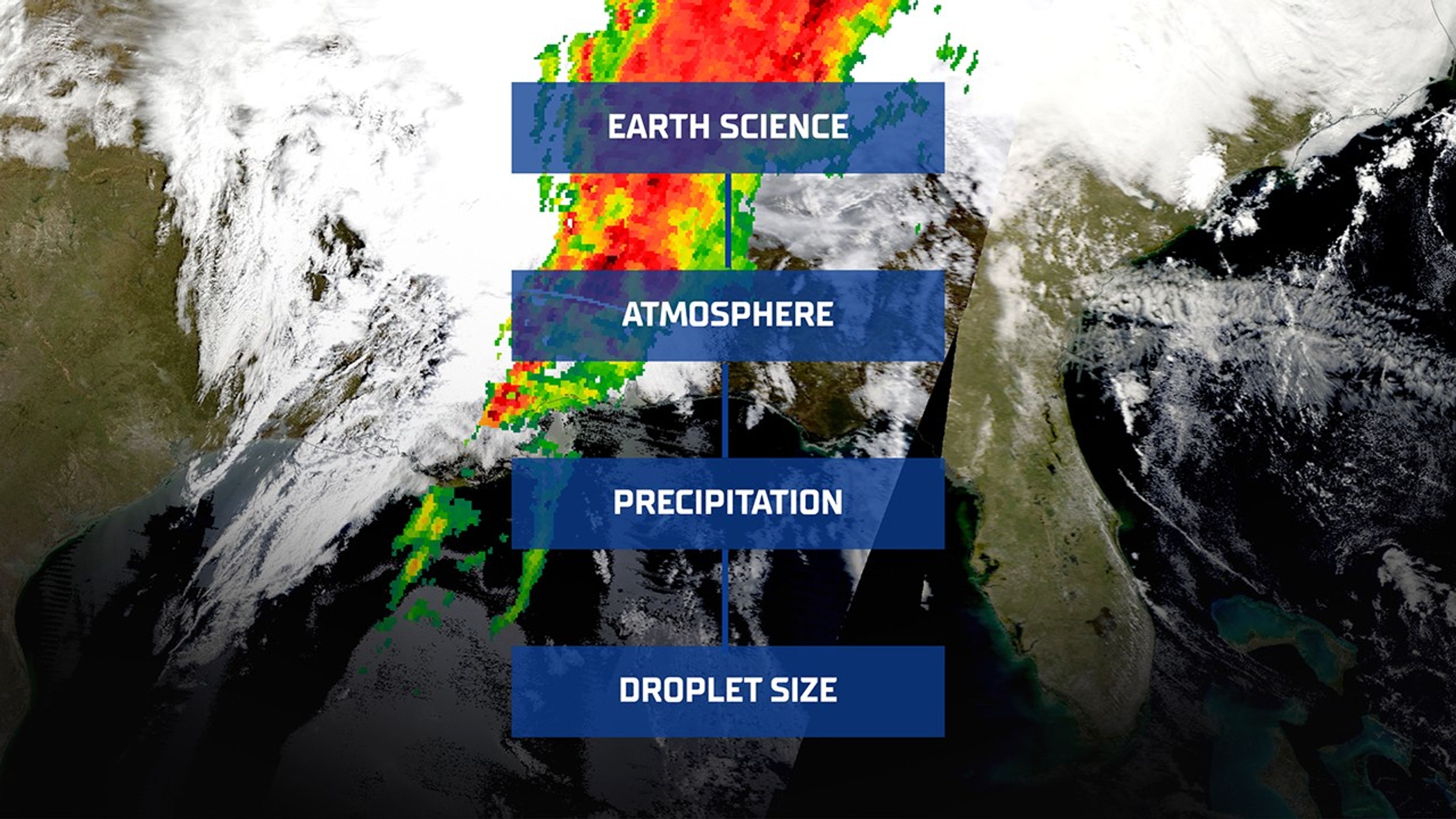
Smarter Searching: NASA AI Makes Science Data Easier to Find Image snapshot taken from NASA Worldview of NASA’s Global Precipitation Measurement (GPM) mission on March 15, 2025 showing heavy rain across the southeastern U.S. with an overlay of the GCMD Keyword Recommender for Earth Science, Atmosphere, Precipitation, Droplet Size. NASA WorldviewImagine shopping for a new pair of running shoes online. If each seller described them differently—one calling them “sneakers,” another “trainers,” and someone else “footwear for exercise”—you’d quickly feel lost in a sea of mismatched terminology. Fortunately, most online stores use standardized categories and filters, so you can click through a simple path: Women’s > Shoes > Running Shoes—and quickly find what you need.
Now, scale that problem to scientific research. Instead of sneakers, think “aerosol optical depth” or “sea surface temperature.” Instead of a handful of retailers, it is thousands of researchers, instruments, and data providers. Without a common language for describing data, finding relevant Earth science datasets would be like trying to locate a needle in a haystack, blindfolded.
That’s why NASA created the Global Change Master Directory (GCMD), a standardized vocabulary that helps scientists tag their datasets in a consistent and searchable way. But as science evolves, so does the challenge of keeping metadata organized and discoverable.
To meet that challenge, NASA’s Office of Data Science and Informatics (ODSI) at the agency’s Marshall Space Flight Center (MSFC) in Huntsville, Alabama, developed the GCMD Keyword Recommender (GKR): a smart tool designed to help data providers and curators assign the right keywords, automatically.
Smarter Tagging, Accelerated DiscoveryThe upgraded GKR model isn’t just a technical improvement; it’s a leap forward in how we organize and access scientific knowledge. By automatically recommending precise, standardized keywords, the model reduces the burden on human curators while ensuring metadata quality remains high. This makes it easier for researchers, students, and the public to find exactly the datasets they need.
It also sets the stage for broader applications. The techniques used in GKR, like applying focal loss to rare-label classification problems and adapting pre-trained transformers to specialized domains, can benefit fields well beyond Earth science.
Metadata MatchmakerThe newly upgraded GKR model tackles a massive challenge in information science known as extreme multi-label classification. That’s a mouthful, but the concept is straightforward: Instead of predicting just one label, the model must choose many, sometimes dozens, from a set of thousands. Each dataset may need to be tagged with multiple, nuanced descriptors pulled from a controlled vocabulary.
Think of it like trying to identify all the animals in a photograph. If there’s just a dog, it’s easy. But if there’s a dog, a bird, a raccoon hiding behind a bush, and a unicorn that only shows up in 0.1% of your training photos, the task becomes far more difficult. That’s what GKR is up against: tagging complex datasets with precision, even when examples of some keywords are scarce.
And the problem is only growing. The new version of GKR now considers more than 3,200 keywords, up from about 430 in its earlier iteration. That’s a sevenfold increase in vocabulary complexity, and a major leap in what the model needs to learn and predict.
To handle this scale, the GKR team didn’t just add more data; they built a more capable model from the ground up. At the heart of the upgrade is INDUS, an advanced language model trained on a staggering 66 billion words drawn from scientific literature across disciplines—Earth science, biological sciences, astronomy, and more.
NASA ODSI’s GCMD Keyword Recommender AI model automatically tags scientific datasets with the help of INDUS, a large language model trained on NASA scientific publications across the disciplines of astrophysics, biological and physical sciences, Earth science, heliophysics, and planetary science. NASA“We’re at the frontier of cutting-edge artificial intelligence and machine learning for science,” said Sajil Awale, a member of the NASA ODSI AI team at MSFC. “This problem domain is interesting, and challenging, because it’s an extreme classification problem where the model needs to differentiate even very similar keywords/tags based on small variations of context. It’s exciting to see how we have leveraged INDUS to build this GKR model because it is designed and trained for scientific domains. There are opportunities to improve INDUS for future uses.”
This means that the new GKR isn’t just guessing based on word similarities; it understands the context in which keywords appear. It’s the difference between a model knowing that “precipitation” might relate to weather versus recognizing when it means a climate variable in satellite data.
And while the older model was trained on only 2,000 metadata records, the new version had access to a much richer dataset of more than 43,000 records from NASA’s Common Metadata Repository. That increased exposure helps the model make more accurate predictions.
The Common Metadata Repository is the backend behind the following data search and discovery services:
- Earthdata Search
- International Data Network
One of the biggest hurdles in a task like this is class imbalance. Some keywords appear frequently; others might show up just a handful of times. Traditional machine learning approaches, like cross-entropy loss, which was used initially to train the model, tend to favor the easy, common labels, and neglect the rare ones.
To solve this, NASA’s team turned to focal loss, a strategy that reduces the model’s attention to obvious examples and shifts focus toward the harder, underrepresented cases.
The result? A model that performs better across the board, especially on the keywords that matter most to specialists searching for niche datasets.
From Metadata to MissionUltimately, science depends not only on collecting data, but on making that data usable and discoverable. The updated GKR tool is a quiet but critical part of that mission. By bringing powerful AI to the task of metadata tagging, it helps ensure that the flood of Earth observation data pouring in from satellites and instruments around the globe doesn’t get lost in translation.
In a world awash with data, tools like GKR help researchers find the signal in the noise and turn information into insight.
Beyond powering GKR, the INDUS large language model is also enabling innovation across other NASA SMD projects. For example, INDUS supports the Science Discovery Engine by helping automate metadata curation and improving the relevancy ranking of search results.The diverse applications reflect INDUS’s growing role as a foundational AI capability for SMD.
The INDUS large language model is funded by the Office of the Chief Science Data Officer within NASA’s Science Mission Directorate at NASA Headquarters in Washington. The Office of the Chief Science Data Officer advances scientific discovery through innovative applications and partnerships in data science, advanced analytics, and artificial intelligence.
Share Details Last Updated Jul 10, 2025 Related Terms Explore More 8 min read NASA’s Webb Scratches Beyond Surface of Cat’s Paw for 3rd AnniversaryArticle
1 hour ago
2 min read Polar Tourists Give Positive Reviews to NASA Citizen Science in Antarctica
Article
1 day ago
2 min read Hubble Observations Give “Missing” Globular Cluster Time to Shine
Article
7 days ago
Keep Exploring Discover Related Topics
Missions
Humans in Space
Climate Change
Solar System
Smarter Searching: NASA AI Makes Science Data Easier to Find
6 min read
Smarter Searching: NASA AI Makes Science Data Easier to Find Image snapshot taken from NASA Worldview of NASA’s Global Precipitation Measurement (GPM) mission on March 15, 2025 showing heavy rain across the southeastern U.S. with an overlay of the GCMD Keyword Recommender for Earth Science, Atmosphere, Precipitation, Droplet Size. NASA WorldviewImagine shopping for a new pair of running shoes online. If each seller described them differently—one calling them “sneakers,” another “trainers,” and someone else “footwear for exercise”—you’d quickly feel lost in a sea of mismatched terminology. Fortunately, most online stores use standardized categories and filters, so you can click through a simple path: Women’s > Shoes > Running Shoes—and quickly find what you need.
Now, scale that problem to scientific research. Instead of sneakers, think “aerosol optical depth” or “sea surface temperature.” Instead of a handful of retailers, it is thousands of researchers, instruments, and data providers. Without a common language for describing data, finding relevant Earth science datasets would be like trying to locate a needle in a haystack, blindfolded.
That’s why NASA created the Global Change Master Directory (GCMD), a standardized vocabulary that helps scientists tag their datasets in a consistent and searchable way. But as science evolves, so does the challenge of keeping metadata organized and discoverable.
To meet that challenge, NASA’s Office of Data Science and Informatics (ODSI) at the agency’s Marshall Space Flight Center (MSFC) in Huntsville, Alabama, developed the GCMD Keyword Recommender (GKR): a smart tool designed to help data providers and curators assign the right keywords, automatically.
Smarter Tagging, Accelerated DiscoveryThe upgraded GKR model isn’t just a technical improvement; it’s a leap forward in how we organize and access scientific knowledge. By automatically recommending precise, standardized keywords, the model reduces the burden on human curators while ensuring metadata quality remains high. This makes it easier for researchers, students, and the public to find exactly the datasets they need.
It also sets the stage for broader applications. The techniques used in GKR, like applying focal loss to rare-label classification problems and adapting pre-trained transformers to specialized domains, can benefit fields well beyond Earth science.
Metadata MatchmakerThe newly upgraded GKR model tackles a massive challenge in information science known as extreme multi-label classification. That’s a mouthful, but the concept is straightforward: Instead of predicting just one label, the model must choose many, sometimes dozens, from a set of thousands. Each dataset may need to be tagged with multiple, nuanced descriptors pulled from a controlled vocabulary.
Think of it like trying to identify all the animals in a photograph. If there’s just a dog, it’s easy. But if there’s a dog, a bird, a raccoon hiding behind a bush, and a unicorn that only shows up in 0.1% of your training photos, the task becomes far more difficult. That’s what GKR is up against: tagging complex datasets with precision, even when examples of some keywords are scarce.
And the problem is only growing. The new version of GKR now considers more than 3,200 keywords, up from about 430 in its earlier iteration. That’s a sevenfold increase in vocabulary complexity, and a major leap in what the model needs to learn and predict.
To handle this scale, the GKR team didn’t just add more data; they built a more capable model from the ground up. At the heart of the upgrade is INDUS, an advanced language model trained on a staggering 66 billion words drawn from scientific literature across disciplines—Earth science, biological sciences, astronomy, and more.
NASA ODSI’s GCMD Keyword Recommender AI model automatically tags scientific datasets with the help of INDUS, a large language model trained on NASA scientific publications across the disciplines of astrophysics, biological and physical sciences, Earth science, heliophysics, and planetary science. NASA“We’re at the frontier of cutting-edge artificial intelligence and machine learning for science,” said Sajil Awale, a member of the NASA ODSI AI team at MSFC. “This problem domain is interesting, and challenging, because it’s an extreme classification problem where the model needs to differentiate even very similar keywords/tags based on small variations of context. It’s exciting to see how we have leveraged INDUS to build this GKR model because it is designed and trained for scientific domains. There are opportunities to improve INDUS for future uses.”
This means that the new GKR isn’t just guessing based on word similarities; it understands the context in which keywords appear. It’s the difference between a model knowing that “precipitation” might relate to weather versus recognizing when it means a climate variable in satellite data.
And while the older model was trained on only 2,000 metadata records, the new version had access to a much richer dataset of more than 43,000 records from NASA’s Common Metadata Repository. That increased exposure helps the model make more accurate predictions.
The Common Metadata Repository is the backend behind the following data search and discovery services:
- Earthdata Search
- International Data Network
One of the biggest hurdles in a task like this is class imbalance. Some keywords appear frequently; others might show up just a handful of times. Traditional machine learning approaches, like cross-entropy loss, which was used initially to train the model, tend to favor the easy, common labels, and neglect the rare ones.
To solve this, NASA’s team turned to focal loss, a strategy that reduces the model’s attention to obvious examples and shifts focus toward the harder, underrepresented cases.
The result? A model that performs better across the board, especially on the keywords that matter most to specialists searching for niche datasets.
From Metadata to MissionUltimately, science depends not only on collecting data, but on making that data usable and discoverable. The updated GKR tool is a quiet but critical part of that mission. By bringing powerful AI to the task of metadata tagging, it helps ensure that the flood of Earth observation data pouring in from satellites and instruments around the globe doesn’t get lost in translation.
In a world awash with data, tools like GKR help researchers find the signal in the noise and turn information into insight.
Beyond powering GKR, the INDUS large language model is also enabling innovation across other NASA SMD projects. For example, INDUS supports the Science Discovery Engine by helping automate metadata curation and improving the relevancy ranking of search results.The diverse applications reflect INDUS’s growing role as a foundational AI capability for SMD.
The INDUS large language model is funded by the Office of the Chief Science Data Officer within NASA’s Science Mission Directorate at NASA Headquarters in Washington. The Office of the Chief Science Data Officer advances scientific discovery through innovative applications and partnerships in data science, advanced analytics, and artificial intelligence.
Share Details Last Updated Jul 10, 2025 Related Terms Explore More 7 min read NASA’s Parker Solar Probe Snaps Closest-Ever Images to SunArticle
59 minutes ago
8 min read NASA’s Webb Scratches Beyond Surface of Cat’s Paw for 3rd Anniversary
Article
5 hours ago
2 min read Polar Tourists Give Positive Reviews to NASA Citizen Science in Antarctica
Article
1 day ago
Keep Exploring Discover Related Topics
Missions
Humans in Space
Climate Change
Solar System
Anatomy of a Space Shuttle
Anatomy of a Space Shuttle
This 2001 illustration labels important parts of a space shuttle orbiter. The orbiter was the heart and brains of the space shuttle and served as the crew transport vehicle that carried astronauts to and from space. The space shuttle was comprised of the orbiter, the main engines, the external tank, and the solid rocket boosters. The space shuttle was the world’s first reusable spacecraft and the first spacecraft in history that could carry large satellites both to and from orbit.
Image credit: NASA
“Hubble at 35 Years” Symposium Explores Insights from Hubble’s Past
As Hubble marks three and a half decades of scientific breakthroughs and technical resilience, the “Hubble at 35 Years” symposium offers a platform to reflect on the mission’s historical, operational, and scientific legacy. Hubble’s trajectory—from early challenges to becoming a symbol of American scientific ingenuity—presents valuable lessons in innovation, collaboration, and crisis response. Bringing together scientists, engineers, and historians at NASA Headquarters ensures that this legacy informs current and future mission planning, including operations for the James Webb Space Telescope, Roman Space Telescope, and other next-generation observatories. The symposium not only honors Hubble’s transformative contributions but also reinforces NASA’s commitment to learning from the past to shape a more effective and ambitious future for space science.
Hubble at 35 YearsLessons Learned in Scientific Discovery and NASA Flagship Mission Operations
October 16–17, 2025
James Webb Auditorium, NASA HQ, Washington, D.C.
The story of the Hubble Space Telescope confirms its place as the most transformative and significant astronomical observatory in history. Once called “the eighth wonder of the world” by a former NASA administrator, Hubble’s development since its genesis in the early 1970s and its launch, repair, and ultimate impact since 1990 provide ample opportunity to apply insights from its legacy. Scientists and engineers associated with groundbreaking discoveries have always operated within contexts shaped by forces including the government, private industry, the military, and the public at large. The purpose of this symposium is to explore the insights from Hubble’s past and draw connections that can inform the development of mission work today and for the future.
Contact the Organizer Keep Exploring Discover More Topics From NASAHubble’s 35th Anniversary
Universe
Humans In Space
NASA History
NASA, International Astronauts Answer Questions from Florida Students
Students in Big Pine Key, Florida, will have the chance to have NASA astronauts aboard the International Space Station answer their prerecorded questions.
At 10:05 a.m. EDT on Monday, July 14, NASA astronaut Nicole Ayers and JAXA (Japan Aerospace Exploration Agency) astronaut Takuya Onishi will answer questions submitted by students.
Watch the 20-minute Earth-to-space call on NASA STEM’s YouTube Channel.
The event is hosted by the Seacamp Association of Big Pine Key, Florida, which provides immersive science lessons for youth interested in discovering the sea. The event will be attended by local Monroe County students, as well as national and international campers ages 10-17 years old. The goal of the event is to help students make connections between astronauts training in space and scientists working in the sea.
Media interested in covering the event must RSVP by 5 p.m. EDT, Friday, July 11, to Judy Gregoire at: 305-872-2331 or email at: info@seacamp.org.
For nearly 25 years, astronauts have continuously lived and worked aboard the space station, testing technologies, performing science, and developing skills needed to explore farther from Earth. Astronauts aboard the orbiting laboratory communicate with NASA’s Mission Control Center in Houston 24 hours a day through SCaN’s (Space Communications and Navigation) Near Space Network.
Important research and technology investigations taking place aboard the space station benefit people on Earth and lay the groundwork for other agency missions. As part of NASA’s Artemis campaign, the agency will send astronauts to the Moon to prepare for future human exploration of Mars; inspiring Golden Age explorers and ensuring the United States continues to lead in space exploration and discovery.
See videos of astronauts aboard the space station at:
https://www.nasa.gov/stemonstation
-end-
Gerelle Dodson
Headquarters, Washington
202-358-1600
gerelle.q.dodson@nasa.gov
Sandra Jones
Johnson Space Center, Houston
281-483-5111
sandra.p.jones@nasa.gov
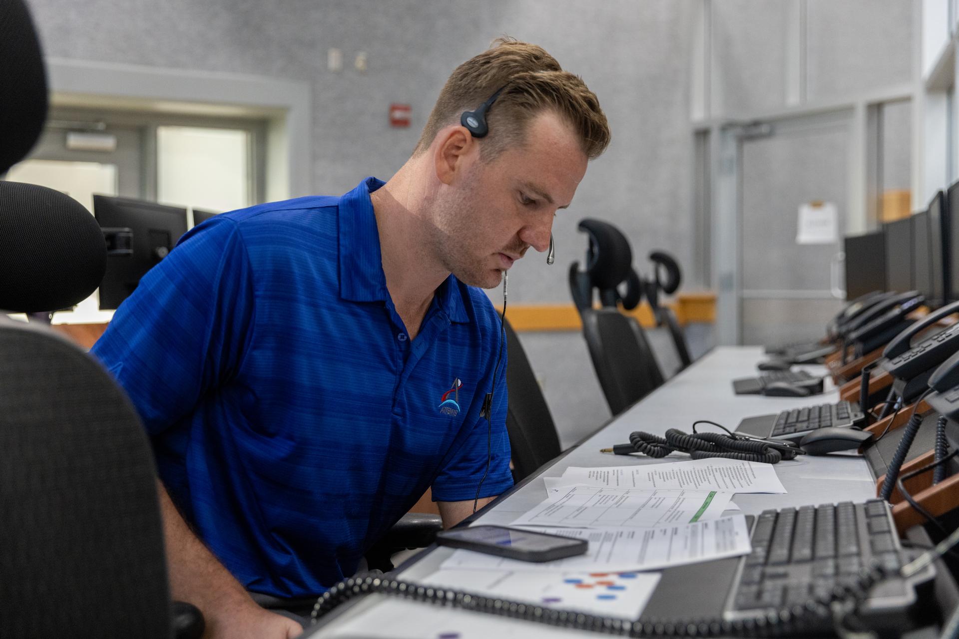
I Am Artemis: Joe Pavicic
Listen to this audio excerpt from Joe Pavicic, Artemis operations project engineer
0:00 / 0:00
Your browser does not support the audio element.Joe Pavicic will never forget when he told the Artemis launch director teams were NO-GO for launch.
Before Artemis I lifted off from NASA’s Kennedy Space Center in Florida in November 2022, the launch team made multiple launch attempts the months prior.
“During a previous Artemis I launch attempt, there was an issue with engine three,” said Pavicic, operations project engineer who worked on the engines console during Artemis I. “One sensor was showing that it wasn’t seeing liquid hydrogen through it. It was showing that it was at ambient temperature.”
And I had to tell the launch director, ‘We can't get there today with the current criteria that we have. My recommendation is a NO-GO.’Joe pavicic
Operations Project Engineer
Prior to engine ignition, launch team controllers must first chill the engines before the cryogenic liquid propellant fuels and lifts the SLS (Space Launch System) rocket and Orion spacecraft into the heavens and onward to the Moon. Chilling the engines ensures the hardware doesn’t get damaged when exposed to the super-cooled liquid hydrogen at -423 degrees Fahrenheit.
NASA/Kim Shiflett“We tried everything we could think of,” Pavicic recalls. “Any procedure we could try, we tried it, and we just never saw those rates that we should have.”
Thus, Pavicic, who is originally from West Palm Beach and studied aerospace engineering at Embry Riddle Aeronautical University in Daytona Beach, Florida, went back to the drawing board with the rest of his team, working days and nights rewriting procedures and learning new lessons about the engines and sensors until they were finally able to get to a successful launch.
“I just remember after I said, 'NO-GO,' I felt like all these people came to watch the launch, all my family, and I'm like, ‘I'm the guy,' but I told myself, ‘I'm not going to be the one to say this for the next launch attempt. I'm going to do what I can to get us there.’joe pavicic
Operations Project Engineer
NASA successfully launched and flew the Artemis I mission and now, Pavicic is working as one of the operations project engineers, continuing to help the launch team develop new launch commit criteria and procedures within the launch countdown ahead of Artemis II, the first crewed Artemis mission, which will send four astronauts around the Moon and back in 10 days next year.
About the AuthorAntonia Jaramillo Share Details Last Updated Jul 09, 2025 Related Terms Explore More 3 min read Aaisha Ali: From Marine Biology to the Artemis Control Room Article 3 days ago 2 min read NASA Announces Winners of 2025 Human Lander Challenge Article 2 weeks ago 4 min read I Am Artemis: Patrick Junen Article 2 weeks ago Keep Exploring Discover More Topics From NASAMissions
Humans in Space
Climate Change
Solar System
I Am Artemis: Joe Pavicic
Listen to this audio excerpt from Joe Pavicic, Artemis operations project engineer
0:00 / 0:00
Your browser does not support the audio element.Joe Pavicic will never forget when he told the Artemis launch director teams were NO-GO for launch.
Before Artemis I lifted off from NASA’s Kennedy Space Center in Florida in November 2022, the launch team made multiple launch attempts the months prior.
“During a previous Artemis I launch attempt, there was an issue with engine three,” said Pavicic, operations project engineer who worked on the engines console during Artemis I. “One sensor was showing that it wasn’t seeing liquid hydrogen through it. It was showing that it was at ambient temperature.”
And I had to tell the launch director, ‘We can't get there today with the current criteria that we have. My recommendation is a NO-GO.’Joe pavicic
Operations Project Engineer
Prior to engine ignition, launch team controllers must first chill the engines before the cryogenic liquid propellant fuels and lifts the SLS (Space Launch System) rocket and Orion spacecraft into the heavens and onward to the Moon. Chilling the engines ensures the hardware doesn’t get damaged when exposed to the super-cooled liquid hydrogen at -423 degrees Fahrenheit.
NASA/Kim Shiflett“We tried everything we could think of,” Pavicic recalls. “Any procedure we could try, we tried it, and we just never saw those rates that we should have.”
Thus, Pavicic, who is originally from West Palm Beach and studied aerospace engineering at Embry Riddle Aeronautical University in Daytona Beach, Florida, went back to the drawing board with the rest of his team, working days and nights rewriting procedures and learning new lessons about the engines and sensors until they were finally able to get to a successful launch.
“I just remember after I said, 'NO-GO,' I felt like all these people came to watch the launch, all my family, and I'm like, ‘I'm the guy,' but I told myself, ‘I'm not going to be the one to say this for the next launch attempt. I'm going to do what I can to get us there.’joe pavicic
Operations Project Engineer
NASA successfully launched and flew the Artemis I mission and now, Pavicic is working as one of the operations project engineers, continuing to help the launch team develop new launch commit criteria and procedures within the launch countdown ahead of Artemis II, the first crewed Artemis mission, which will send four astronauts around the Moon and back in 10 days next year.
About the AuthorAntonia Jaramillo Share Details Last Updated Jul 09, 2025 Related Terms Explore More 3 min read Aaisha Ali: From Marine Biology to the Artemis Control Room Article 2 days ago 2 min read NASA Announces Winners of 2025 Human Lander Challenge Article 2 weeks ago 4 min read I Am Artemis: Patrick Junen Article 2 weeks ago Keep Exploring Discover More Topics From NASAMissions
Humans in Space
Climate Change
Solar System
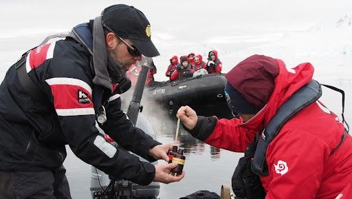
Polar Tourists Give Positive Reviews to NASA Citizen Science in Antarctica
2 min read
Polar Tourists Give Positive Reviews to NASA Citizen Science in AntarcticaCitizen science projects result in an overwhelmingly positive impact on the polar tourism experience. That’s according to a new paper analyzing participant experiences in the first two years of FjordPhyto, a NASA Citizen Science project..
The FjordPhyto citizen science project invites travelers onboard expedition cruise vessels to gather data and samples during the polar summer season, helping researchers understand changes in microalgae communities in response to melting glaciers. Travelers in Antarctica from November to March help collect phytoplankton and ocean data from polar regions facilitated by trained expedition guides.
The new research found that ninety-seven percent of respondents reported that participating in citizen science enriched their travel experience. The paper provides a first understanding of the impact of citizen science projects on the tourism experience.
“I was worried that I would feel guilty being a tourist in a place as remote and untouched as Antarctica,” said one anonymous FjordPhyto participant. “But being able to learn and be a part of citizen science, whilst constantly being reminded of our environmental responsibilities, made me feel less like just a visitor and more a part of keeping the science culture that Antarctica is known for alive and well.”
For more information and to sign up, visit the FjordPhyto website.
Travelers in Antarctica participate in collecting phytoplankton and ocean data from polar regions facilitated by trained expedition guides. Credit: Mathew Farrell courtesy of Robert Gilmore Share Details Last Updated Jul 09, 2025 Related Terms Explore More 2 min read NASA Citizen Scientists Find New Eclipsing Binary StarsArticle
2 weeks ago
2 min read Live or Fly a Plane in California? Help NASA Measure Ozone Pollution!
Article
2 weeks ago
5 min read NASA Launching Rockets Into Radio-Disrupting Clouds
Article
4 weeks ago
Continuing the Quest for Clays
- Perseverance Home
- Science
- News and Features
- Multimedia
- Mars Missions
- Mars Home
3 min read
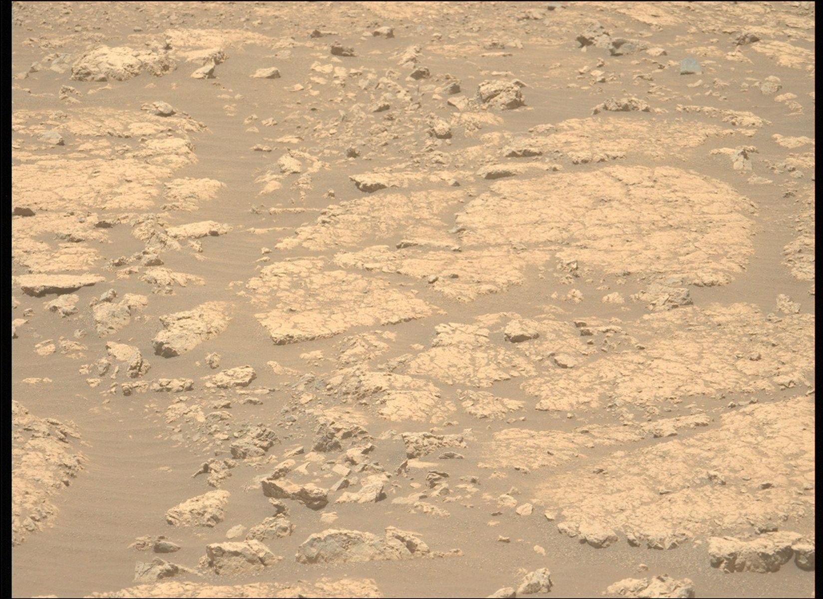
Continuing the Quest for Clays NASA’s Mars Perseverance rover acquired this image showing the target “Jigging Cove,” named by Make-A-Wish participant Madeline, located in the center of the image. Perseverance used its Left Mastcam-Z camera, one of a pair of cameras located high on the rover’s mast, to capture the image on June 27, 2025 (Sol 1547, or Martian day 1,547 of the Mars 2020 mission) at the local mean solar time of 11:26:04. NASA/JPL-Caltech/ASUWritten by Eleanor Moreland, Ph.D. Student Collaborator at Rice University
For the past month and a half, Perseverance has been exploring the Krokodillen plateau in search of clay-bearing rocks. An earlier blog discussed that these rocks could hold clues to Mars’ watery past, and Perseverance has been exploring multiple potential locations to find a suitable target to sample. When a coring target could not be found at the previous outcrop, the Science Team decided to return to the “Main Topsail” locality. In a single drive to this area, Perseverance drove 411.7 meters (1,350.7 feet, or just over a quarter mile) — the longest driving distance ever accomplished by a robotic vehicle on another planet. Go, Percy, go!
Back in the region near “Main Topsail” and “Salmon Point,” the team attempted to abrade and sample the clay-bearing rocks at a few different targets. These rocks, however, are proving very breakable and difficult to sample and abrade. Perseverance has experienced challenging fine-grained rocks before, such as during the fan front campaign inside Jezero crater. In that scenario and this one, the Science and Engineering teams work together diligently to find the highest priority targets and find rocks that could withstand the abrasion and coring processes. In this case, the team has decided to return to the site of a previous abrasion, “Strong Island,” to sample the rock we have already abraded and analyzed. This abrasion showed the strong clay signature the team is looking to sample, and we will make another coring attempt this week.
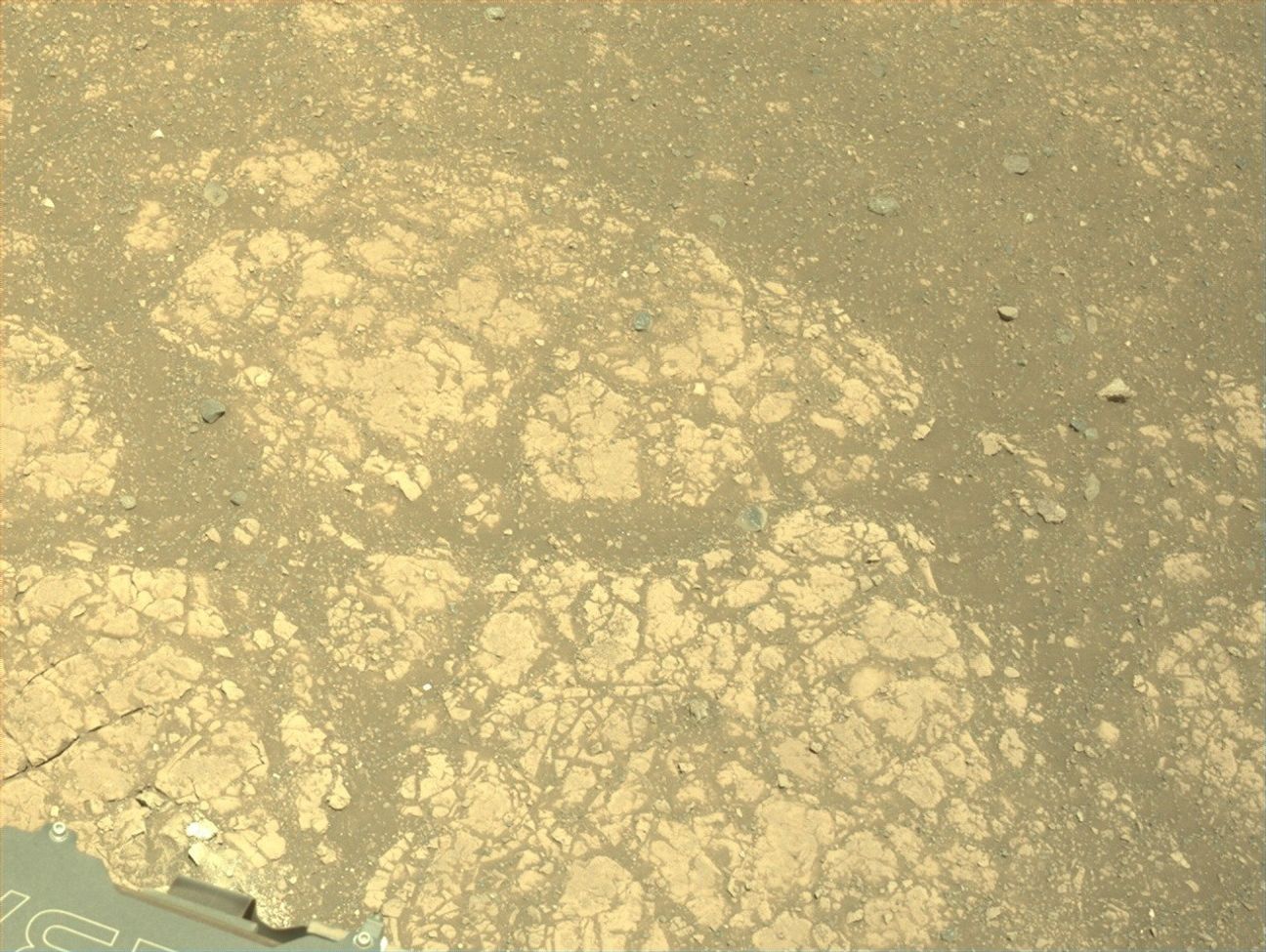
NASA’s Mars Perseverance rover acquired this image of the target “Gallants,” named by Make-A-Wish participant Joshua, located in the lower left quadrant of the image. Perseverance used its onboard Left Navigation Camera (Navcam), which is located high on the rover’s mast and aids in driving, to capture the image on July 1, 2025 (Sol 1551 or Martian day 1,551 of the Mars 2020 mission), at the local mean solar time of 13:10:08. NASA/JPL-CaltechThis past week, the Perseverance team hosted two very special visitors, Madeline and Joshua, and had the unique honor of fulfilling their wishes through the Make-A-Wish foundation. During their visits to JPL, Madeline and Joshua were named honorary Mars 2020 Operations Team Members. They visited the test rovers in the JPL Mars Yard, watched data arrive from the rover with the Perseverance operations team, and attended a rover planning meeting, collaborating with the science and engineering team members on campus. Madeline and Joshua will forever be connected to the Mars 2020 mission, as each selected the name of one of our planning targets. Madeline’s target, “Jigging Cove,” was a target for Mastcam-Z and SuperCam “all techniques” analysis, including LIBS, VISIR, and RMI. Joshua’s selection, “Gallants,” will be used for the next coring target. Carrying forward the resilience shown by Madeline and Joshua, Perseverance will attempt to sample this clay-rich bedrock before continuing the investigation along the Jezero crater rim.
Share Details Last Updated Jul 08, 2025 Related Terms Explore More 2 min read Curiosity Blog, Sols 4589 – 4592: Setting up to explore Volcán Peña BlancaArticle
21 hours ago
2 min read Curiosity Blog, Sol 4588: Ridges and troughs
Article
22 hours ago
2 min read Curiosity Blog, Sols 4586-4587: Straight Drive, Strategic Science
Article
7 days ago
Keep Exploring Discover More Topics From NASA Mars
Mars is the fourth planet from the Sun, and the seventh largest. It’s the only planet we know of inhabited…
All Mars Resources
Explore this collection of Mars images, videos, resources, PDFs, and toolkits. Discover valuable content designed to inform, educate, and inspire,…
Rover Basics
Each robotic explorer sent to the Red Planet has its own unique capabilities driven by science. Many attributes of a…
Mars Exploration: Science Goals
The key to understanding the past, present or future potential for life on Mars can be found in NASA’s four…
