
NASA
NASA Announces Winners in University Aeronautics Competition
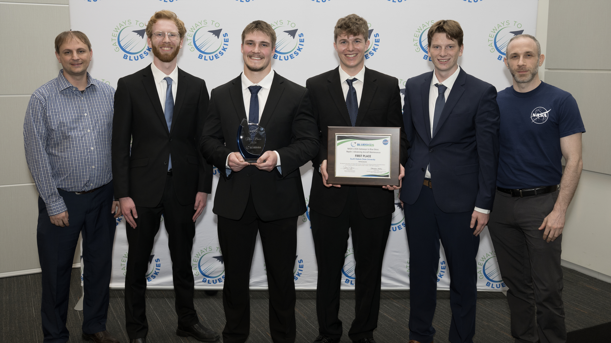
The South Dakota State University team took first place at NASA’s fifth annual Gateways to Blue Skies Competition, which challenged student teams to address a critical element of U.S. aviation: aircraft maintenance.
This year’s competition, RepAir: Advancing Aircraft Maintenance, asked teams of postsecondary students to develop innovative systems and practices that could advance commercial aircraft maintenance and repair operations by 2035. The competition, sponsored by NASA’s University Innovation project within the agency’s Aeronautics Research Mission Directorate, supported the agency’s objectives of fostering innovative research and strengthening the future aviation workforce.
“This year’s finalists proposed novel ideas to equip companies and their workers with innovative technologies to help keep our nation’s planes airworthy. This is especially critical in a time where flight safety is more commonly in the spotlight and where workforce shortages lead to challenges and opportunities in aviation,” said Steven Holz, associate project manager for NASA’s University Innovation Project and judging panel chair for Gateways to Blue Skies. “Our panel of industry and subject matter experts were excited about the possibilities these concepts could bring, as well as shared insights needed for these teams to push forward for real-world implementation.”
The winning project, WINGMAN, proposed augmented reality safety glasses equipped with voice-controlled manuals, automatic documentation, and photo recognition that could assist aircraft mechanics during routine daily servicing and minor repairs. The glasses would function as the mechanic’s “wingman,” enabling hands-free access to the information and reporting mechanisms required for line inspections.
The WINGMAN team presented their research along with eight finalists at the 2026 Gateways to Blue Skies Forum held May 18 and 19 at NASA’s Langley Research Center in Hampton, Virginia. The forum was judged by subject matter experts from NASA, the Federal Aviation Administration, and industry, including representatives from Southwest Airlines and American Airlines. Students at the forum had the opportunity to network with NASA and industry experts, tour the center, and gain insight into potential careers. The event was livestreamed, and the presentations were recorded.
The winning team members will have the opportunity to intern at one of NASA’s four aeronautics research centers during the 2026-27 academic year, including NASA Langley, NASA’s Glenn Research Center in Cleveland, NASA’s Ames Research Center in California’s Silicon Valley, and NASA’s Armstrong Flight Research Center in Edwards, California.
“It was super exciting to participate in Gateways to Blue Skies, especially with the really interesting concepts this year,” said Owen Diede, WINGMAN team lead. “We couldn’t have done it without the feedback and support from our faculty advisor, Dr. Todd Letcher, as well as our design review committee, Dr. Ruyi Lian and Dr. Cody Christensen. This was a fantastic opportunity to learn and grow, and we are incredibly thankful for the experience.”
Other recognitions included:
- Best Infographic: University of California, Irvine
Aishield: Aircraft Structural Health Intelligence for Evaluation and Lifecycle Detection - Future Game-Changer: University of Georgia
Quasar: Quantum Sensing Aerial Reporting - Safety Spotlight: South Dakota State University
SPIDER (Surveying Platform and Inspection Device for Enclosed Regions)
The commercial aviation industry is a crucial component of the U.S. economy, yet it faces significant challenges due to a shortage of qualified maintenance workers and increasing demands to keep aircraft running for longer. NASA is dedicated to working with commercial, academic, and government partners to advance the capabilities and performance of U.S. aviation.
The Gateways to Blue Skies Challenge is part of the Transformative Aeronautics Concepts Program in NASA’s Aeronautics Research Mission Directorate. The NASA Tournament Lab, part of the Prizes, Challenges, and Crowdsourcing Program in the Space Technology Mission Directorate, manages the challenge through the National Institute of Aerospace on behalf of NASA.
For more information about NASA’s Aeronautics Research Mission Directorate, visit:
NASA Announces Winners in University Aeronautics Competition
The South Dakota State University team took first place at NASA’s fifth annual Gateways to Blue Skies Competition, which challenged student teams to address a critical element of U.S. aviation: aircraft maintenance.
This year’s competition, RepAir: Advancing Aircraft Maintenance, asked teams of postsecondary students to develop innovative systems and practices that could advance commercial aircraft maintenance and repair operations by 2035. The competition, sponsored by NASA’s University Innovation project within the agency’s Aeronautics Research Mission Directorate, supported the agency’s objectives of fostering innovative research and strengthening the future aviation workforce.
“This year’s finalists proposed novel ideas to equip companies and their workers with innovative technologies to help keep our nation’s planes airworthy. This is especially critical in a time where flight safety is more commonly in the spotlight and where workforce shortages lead to challenges and opportunities in aviation,” said Steven Holz, associate project manager for NASA’s University Innovation Project and judging panel chair for Gateways to Blue Skies. “Our panel of industry and subject matter experts were excited about the possibilities these concepts could bring, as well as shared insights needed for these teams to push forward for real-world implementation.”
The winning project, WINGMAN, proposed augmented reality safety glasses equipped with voice-controlled manuals, automatic documentation, and photo recognition that could assist aircraft mechanics during routine daily servicing and minor repairs. The glasses would function as the mechanic’s “wingman,” enabling hands-free access to the information and reporting mechanisms required for line inspections.
The WINGMAN team presented their research along with eight finalists at the 2026 Gateways to Blue Skies Forum held May 18 and 19 at NASA’s Langley Research Center in Hampton, Virginia. The forum was judged by subject matter experts from NASA, the Federal Aviation Administration, and industry, including representatives from Southwest Airlines and American Airlines. Students at the forum had the opportunity to network with NASA and industry experts, tour the center, and gain insight into potential careers. The event was livestreamed, and the presentations were recorded.
The winning team members will have the opportunity to intern at one of NASA’s four aeronautics research centers during the 2026-27 academic year, including NASA Langley, NASA’s Glenn Research Center in Cleveland, NASA’s Ames Research Center in California’s Silicon Valley, and NASA’s Armstrong Flight Research Center in Edwards, California.
“It was super exciting to participate in Gateways to Blue Skies, especially with the really interesting concepts this year,” said Owen Diede, WINGMAN team lead. “We couldn’t have done it without the feedback and support from our faculty advisor, Dr. Todd Letcher, as well as our design review committee, Dr. Ruyi Lian and Dr. Cody Christensen. This was a fantastic opportunity to learn and grow, and we are incredibly thankful for the experience.”
Other recognitions included:
- Best Infographic: University of California, Irvine
Aishield: Aircraft Structural Health Intelligence for Evaluation and Lifecycle Detection - Future Game-Changer: University of Georgia
Quasar: Quantum Sensing Aerial Reporting - Safety Spotlight: South Dakota State University
SPIDER (Surveying Platform and Inspection Device for Enclosed Regions)
The commercial aviation industry is a crucial component of the U.S. economy, yet it faces significant challenges due to a shortage of qualified maintenance workers and increasing demands to keep aircraft running for longer. NASA is dedicated to working with commercial, academic, and government partners to advance the capabilities and performance of U.S. aviation.
The Gateways to Blue Skies Challenge is part of the Transformative Aeronautics Concepts Program in NASA’s Aeronautics Research Mission Directorate. The NASA Tournament Lab, part of the Prizes, Challenges, and Crowdsourcing Program in the Space Technology Mission Directorate, manages the challenge through the National Institute of Aerospace on behalf of NASA.
For more information about NASA’s Aeronautics Research Mission Directorate, visit:
La NASA informará sobre su estrategia y misiones para la Base Lunar
Read this news release in English here.
La NASA ofrecerá una conferencia de prensa el martes 26 de mayo a las 2 p.m. EDT (hora del este) para compartir los planes para la Base Lunar y destacar los avances hacia una presencia sostenida en la superficie lunar. La sesión informativa para los medios tendrá lugar en la sede central de la agencia en Washington.
Líderes de la agencia hablarán sobre los avances del programa, incluyendo a los nuevos socios de la industria y los planes de la misión. Una vez finalizada la conferencia de prensa, habrá expertos en la materia disponibles para dar entrevistas individuales.
Siga la rueda de prensa en vivo a través de la aplicación NASA+ y el canal de YouTube de la agencia. Descubra cómo ver el contenido de la NASA en diversas plataformas en línea, incluidas las redes sociales (información ofrecida en inglés).
Entre los participantes se encuentran:
- Jared Isaacman, administrador de la NASA
- Lori Glaze, administradora asociada interina, Dirección de Misiones de Desarrollo de Sistemas de Exploración
- Carlos García-Galán, director del programa Base Lunar. García-Galán es hispanohablante.
Los representantes de los medios que no puedan asistir en persona podrán hacer preguntas por teléfono. Para participar en persona o por teléfono, debe confirmar su asistencia a la oficina de prensa de la sede a más tardar a las 11 a.m. del 26 de mayo, enviando un correo a: hq-media@mail.nasa.gov. La política de acreditación de medios de la NASA está disponible en línea (en inglés). La NASA impulsa el desarrollo de la Base Lunar, una iniciativa de exploración e infraestructura lunar a largo plazo diseñada para permitir una presencia humana sostenida y una mayor actividad científica y comercial en el Polo Sur lunar.
Como parte de una edad de oro de innovación y exploración, la NASA enviará astronautas en misiones cada vez más difíciles para explorar más de la Luna con fines de descubrimiento científico y beneficios económicos, y para continuar sentando las bases para las primeras misiones tripuladas a Marte.
Para más información sobre las misiones de la NASA, visite:
https://www.nasa.gov (inglés)
https://ciencia.nasa.gov/ (español)
-fin-
Bethany Stevens / James Gannon / María José Viñas
Sede central, Washington
+1-202-358-1600
bethany.c.stevens@nasa.gov / james.h.gannon@nasa.gov / maria-jose.vinasgarcia@nasa.gov
NASA TechLeap Prize: Robotically Manipulated Payload Challenge
The Robotically Manipulated Payload Challenge — the fifth in the NASA TechLeap Prize series — is a competition to advance persistent infrastructure for in-space servicing, assembly, and manufacturing. NASA Flight Opportunities invites applicants to propose a payload that can be manipulated by a robotic arm in low Earth orbit. Up to three winners will each receive up to $500,000 to develop a flight-ready payload. In addition, NASA intends to provide an opportunity for the winning teams to demonstrate their payload in orbit (at no additional cost). These TechLeap payloads will fly aboard an orbital spacecraft that will rendezvous with the Fly Foundational Robots (FFR) platform. The FFR mission is expected to launch in late 2027, and the TechLeap payloads are slated to launch in early 2028.
Across three phases, applicants will move from ideation to payload build over 12 months. The timeline for this challenge is intentionally rapid, with the goal of increasing the pace of space.
Award: Up to three winners may receive up to $500,000 in prizes across three phases
Challenge Open Date: May 20, 2026
Phase 1 Registration Close Date: July 29, 2026
Application Close Date: August 12, 2026
For more information, visit: https://rmpc.nasatechleap.org/
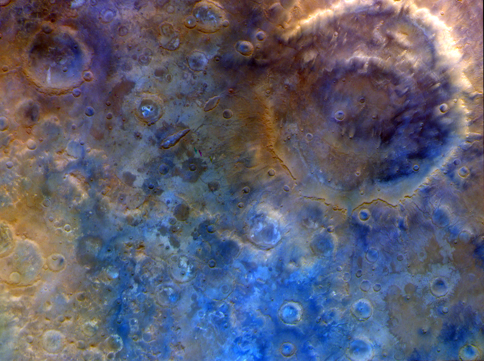
Psyche Spacecraft Completes Mars Flyby
NASA’s Psyche spacecraft completed its close approach of Mars on May 15, coming within 2,864 miles (4,609 kilometers) of the planet’s surface. During the flyby, it took this image and others. This representative color image, captured by Psyche’s multispectral imager instrument, features the double-ring crater Huygens and the surrounding heavily cratered southern highlands.
This flyby used a gravity assist from Mars to provide a critical boost in speed and to adjust the spacecraft’s orbital plane without using any onboard propellant, sending it on its way toward the metal-rich asteroid Psyche. When it arrives in August 2029, it will insert itself into orbit, then map the asteroid and gather science data. If the asteroid proves to be the metallic core of an ancient planetesimal, it could offer a one-of-a-kind window into the interior of rocky planets like Earth.
Learn more about the flyby and see more photos from the event.
Image credit: NASA/JPL-Caltech/ASU
NASA-developed AI Could Help Track Harmful Algae
NASA scientists have developed an artificial intelligence tool to take on a longstanding challenge in ocean waters. In a study recently published in AGU Earth and Space Science, researchers reported the tool was able to fuse data from multiple satellites and detect harmful algal blooms that occurred in western Florida and Southern California.
Severe blooms can pose health risks and cost coastal economies in the United States tens of millions of dollars every year. Areas in Florida such as Tampa Bay and Sarasota have wrestled with the problem for decades. A species called Karenia brevis can thrive in Gulf of America waters, spawning harmful algal blooms that kill wildlife, foul beaches, and sicken swimmers. On the West Coast, blooms of Pseudo-nitzschia have poisoned hundreds of dolphins, California sea lions, and other marine animals in recent years. Toxins from algaecan even enter the air and cause respiratory illness in humans.
To manage the risk, health agencies regularly test waters and issue warnings or beach closures when necessary. The National Oceanic and Atmospheric Administration (NOAA) works with states and other local partners to issue harmful algal bloom forecasts, like weather forecasts, during bloom seasons.
On-site testing requires hours in a boat to manually collect water samples that must be sent to a lab for analysis, taking a day or more and requiring multiple tests. It’s even more challenging to know where to test before a bloom starts spreading.
NASA’s Earth-orbiting satellites already track harmful algal blooms with their unique global view. By bringing together diverse datasets, the new AI tool could serve as a force multiplier to help communities determine where to focus their efforts.
“At the very least, a tool like this can help us know where and when to collect water samples as an algal bloom is starting,” said one of the paper’s coauthors, Michelle Gierach, a scientist at NASA’s Jet Propulsion Laboratory in Southern California. “It can also drive collaboration between specialists, fostering new ways to conduct the science and deliver decision-support products.”
Today, satellites can detect a variety of clues that signal an algal bloom. A hyperspectral sensor aboard NASA’s Plankton, Aerosol, Cloud, ocean Ecosystem (PACE) satellite, for example, can identify algal communities by their size, shape, and pigment. Other instruments like TROPOMI (Tropospheric Monitoring Instrument) pick up on the faint red glow emitted by species such as K. brevis as they photosynthesize.
The study team, consisting of Gierach, Kelly Luis of NASA JPL, and research data scientist Nick LaHaye of Spatial Informatics Group, brought together findings from five space missions or instruments, including PACE and TROPOMI.
The challenge for them was the quantity of raw data involved. How would AI distinguish between deep water and a coastline? Could it recognize a bloom across different data streams? Would it ever be able to handle inputs from both satellites and sensors in the water?
The team developed a self-supervised machine learning system, designed to learn patterns from multiple kinds of satellite data and compare them with field observations. This approach enables AI to recognize relationships between different data sources without needing any labeling in advance.
The system was trained on satellite data collected in 2018 and 2019. Field and lab measurements were then used to add real-world context to the patterns that the system was recognizing. The scientists evaluated the tool’s performance across later time periods in the same geographic areas. Initial results indicate that it can correctly identify and map harmful blooms, including specific species like K. brevis, performing well even in complex coastal waters swirling with sediment, plants, and runoff.
“Applying self-supervised AI to massive streams of satellite data is rapidly becoming a powerful tool for generating actionable ocean intelligence,” said Nadya Vinogradova Shiffer, lead program scientist at NASA Headquarters in Washington.
The team is now improving the tool with more data from more coastlines and expanding tests to other kinds of water bodies, including lakes, with the goal of making it accessible to decision-makers in coming years.
“The aim of this work is to start to bridge technologies to better serve end users and their needs, from aquaculture to tourism,” Luis said. “To do that, we’re going to bring all our NASA assets to the table.”
Media Contacts
Andrew Wang / Andrew Good
Jet Propulsion Laboratory, Pasadena, Calif.
626-379-6874 / 818-393-2433
andrew.wang@jpl.nasa.gov / andrew.c.good@jpl.nasa.gov
2026-034
Explore More 2 min read Fire Chars Santa Rosa IslandThe blaze spread across the southern side of the second-largest island in California’s Channel Islands…
Article 19 hours ago 5 min read NASA’s Psyche Mission Aces Mars Flyby, Targets Metal-Rich Asteroid Article 1 day ago 3 min read Farming in Ancient Lake AgassizThe glacial lake left a layer of silt and clay in southeastern Manitoba, creating fertile…
Article 2 days ago Keep Exploring Discover More Topics From NASAEarth Observations
Earth Science Mission
Mission: PACEWhen did PACE launch? February 8, 2024 Where is PACE? 420 miles (676.5 km) from Earth What does PACE do?…
Jet Propulsion Laboratory
NASA to Provide Update on Moon Base Strategy, Missions
NASA will host a news conference at 2 p.m. EDT, Tuesday, May 26, to share Moon Base plans and highlight progress toward a sustained presence on the lunar surface. The media briefing will take place at the agency’s Headquarters in Washington.
Leadership will discuss program progress, including new industry partners and mission plans. Subject matter experts will be available for one-on-one interviews after the news conference ends.
Watch live on NASA+ and the agency’s YouTube channel. Learn how to watch NASA content through a variety of online platforms, including social media.
Participants include:
- NASA Administrator Jared Isaacman
- Lori Glaze, acting associate administrator, Exploration Systems Development Mission Directorate
- Carlos García-Galán, program executive, Moon Base
Media unable to attend in person may ask questions by telephone. To participate in person or by phone, media must RSVP to the headquarters newsroom no later than 11 a.m. on May 26, at: hq-media@mail.nasa.gov. NASA’s media accreditation policy is available online.
NASA is advancing development of Moon Base, a long-term lunar exploration and infrastructure initiative designed to enable sustained human presence and expanded scientific and commercial activity at the lunar South Pole.
As part of the Golden Age of innovation and exploration, NASA will send astronauts on increasingly difficult missions to explore more of the Moon for scientific discovery, economic benefits, and to build on our foundation for the first crewed missions to Mars.
For more information about NASA’s missions, visit:
-end-
Bethany Stevens / James Gannon
Headquarters, Washington
202-358-1600
bethany.c.stevens@nasa.gov / james.h.gannon@nasa.gov
NASA Releases Technology Priorities to Energize Space Industry
NASA released the 2026 Civil Space Shortfall Ranking list on Wednesday, which integrates more than 400 responses from stakeholders including industry organizations, government agencies, and academia. Shortfalls refer to technology areas requiring further development to meet future exploration, science, and other mission needs. The goal of this document is to rank the space community’s most pervasive shortfalls to help guide NASA’s space technology development and investments.
The greatest technological breakthroughs are built on shared vision. At the intersection of government and industry, we’re poised to use this feedback to accelerate high-risk, high-reward technologies, pushing NASA beyond the cutting edge to enable the near impossible.Greg Stover
Acting associate administrator for NASA’s Space Technology Mission Directorate at the agency’s headquarters in Washington
As NASA lays the foundation for long-term missions to the Moon and paves the way for human exploration on Mars, the top ranked shortfalls reflect the challenges industry is most eager to solve, such as developing infrastructure and capabilities for assets to operate for extended durations in the lunar environment, providing surface mobility and logistics for crew and assets on planetary surfaces, and developing on-board advanced computing capabilities for space operations.
From this year’s public call for feedback, NASA received 454 total external responses. Each response was considered the input of a single individual, not a consolidated response of the organization they represented. The cross-cutting nature of this feedback underscores the importance of public, private partnership to drive U.S. leadership in space technology and energize the space economy.
“This feedback provides an invaluable dataset,” said Angela Krenn, acting chief architect for NASA Technology. “As our process matures, each round of input helps target our resources, ensuring America’s space industry can tackle tomorrow’s greatest challenges. By tapping into the collective expertise of our stakeholders, we turn their insights into fuel for NASA’s next giant leap.”
The 2026 shortfalls process builds on NASA’s first shortfall ranking, which asked participants to rank 187 civil space shortfalls, resulting in an integrated list of technology priorities. Leveraging the feedback provided by stakeholders, this year’s exercise streamlined the process by consolidating the shortfalls into 32 broader, integrated categories. This restructuring maintains the original content’s depth while creating a more efficient and accessible feedback mechanism for participants.
Using the 2026 shortfalls results, NASA Technology selected 40 primary focus areas for its fiscal year 2026 investments. These focus areas combine the quantitative data of the shortfall rankings with considerations from NASA’s Ignition initiatives, science and technology, while establishing paths for collaboration with industry, ensuring relevance with academia, and leveraging overlaps in interests with other government agencies.
The 40 focus areas include several capabilities to enable NASA’s future lunar infrastructure including: landing at the lunar South Pole exploration sites in various illumination conditions with accuracy; excavating and transporting lunar regolith at a scale relevant for a demonstration mission; and providing low power, thermal management, and actuation for distributed surface assets to survive and operate in the lunar environment. The list of 40 focus areas is available on page 10 of the shortfalls document.
To learn more about the civil space shortfall feedback opportunity and results as well as monitor future feedback opportunities, visit:
www.nasa.gov/civilspaceshortfalls
Share Details Last Updated May 20, 2026 EditorLoura HallLocationNASA Headquarters Related Terms Explore More 3 min read NASA Bolsters Golden Age of Exploration with Technology Priorities Article 4 months ago 3 min read NASA Releases First Integrated Ranking of Civil Space Challenges Article 2 years ago