
NASA
How Joint NASA-ESA Sea Level Mission Will Help Hurricane Forecasts
6 min read
Preparations for Next Moonwalk Simulations Underway (and Underwater) Sea surface height can tell meteorologists a lot about extreme storms like hurricanes, including whether they will intensify within a day. This kind of information can help communities better prepare if a hurricane is headed their way. Hurricane Elena is seen here from the space shuttle Discovery in 1985.NASASentinel-6B will measure sea surface height for nearly all of the world’s ocean, providing important data for information products, including weather and hurricane forecasts.
NASA has a long record of monitoring Earth’s sea surface height, information critical not only for tracking how the ocean changes over time but also for hurricane forecasting. These extreme storms can cost the United States billions of dollars each year, wreaking havoc on lives and property. Meteorologists have worked to improve forecasts for a hurricane’s path, or track, as well as its intensity, measured as surface wind speed. Sentinel-6B, the U.S.-European satellite launching later this year, will help in that effort.
The satellite is the second of two spacecraft that constitute the Sentinel-6/Jason-CS (Continuity of Service) mission, a collaboration between NASA, ESA (European Space Agency), EUMETSAT (the European Organisation for the Exploitation of Meteorological Satellites), and the U.S. National Oceanic and Atmospheric Administration (NOAA). With its launch planned for no earlier than Nov. 16, 2025, Sentinel-6B will take over from its twin, Sentinel-6 Michael Freilich, which launched in November 2020 as part of a long line of U.S.-European missions that have monitored sea levels since 1992.
“Sentinel-6 will track global changes in Earth’s ocean — height, heat, and movement — and will improve forecasts of local extremes like floods and hurricanes, linking planetary trends to real-world risks for communities,” said Nadya Vinogradova Shiffer, Sentinel-6 program scientist at NASA Headquarters in Washington.
before after beforeafter before afterBefore and After
Hurricane Milton CurtainToggle2-Up Image Details These illustrations show ocean heat on Oct. 7, 2024, left, and Oct. 9, right, as Hurricane Milton passed over very warm seawater and rapidly grew. Red and yellow indicate more heat; blue and green are cooler. A satellite image of the hurricane shows the storm’s position as it moves toward Florida’s west coast. Credit: NOAAThe decades-long, U.S.-European ocean dataset has been key to helping researchers advance hurricane intensity forecasting. Warm water fuels hurricanes. And since water expands as it warms, sea surface height can tell researchers which regions of the ocean are warm enough to supercharge a hurricane.
“A deep layer of warm seawater is literally taller than a shallow layer of warm water,” said Josh Willis, Sentinel-6B project scientist at NASA’s Jet Propulsion Laboratory in Southern California. So sea surface height can be used as a proxy for the amount of heat in the ocean.
Fueling HurricanesThere are two main ways that forecasters use sea level measurements, said Mark DeMaria, a senior research scientist at Colorado State University in Fort Collins. One way is to help set the proper ocean conditions in ocean-atmosphere hurricane forecast models utilized by the National Hurricane Center.
The second way is by feeding sea level data into machine learning models that forecasters use to predict whether a hurricane will undergo rapid intensification, where its wind speeds increase by 35 mph (56 kph) or more within 24 hours. Meteorologists include both water temperature measurements from sensors drifting in the ocean and sea surface height data collected by Sentinel-6 Michael Freilich as well as other satellites.
Hurricanes churn the ocean as they pass overhead, mixing the top layers of seawater. If the storm encounters a shallow pool of warm seawater, its winds can stir things up, pulling cooler waters from the depths to the surface. This can hinder rapid intensification. But if the warm pool of seawater extends deep into the ocean, those winds will only stir up more warm water, potentially resulting in the hurricane’s rapid intensification.
“Hurricane Milton is a perfect example of this,” said DeMaria, who was previously a branch chief at the National Hurricane Center in Miami and helped to develop hurricane intensity forecast models. Milton experienced an intense period of rapid intensification — an event that was forecast using a model fed partly with data from Sentinel-6 Michael Freilich. From Oct. 6 to Oct. 7, 2024, Milton exploded from a Category 1 hurricane to a Category 5, producing wind speeds as high as 180 mph (289 kph). The storm weakened to a Category 3 — still a major hurricane — by the time it made landfall near Sarasota, Florida, on Oct. 9.
Forecast ImprovementsWhile the U.S.-European series of sea level satellites began collecting measurements in 1992, it wasn’t until the early 2000s that meteorologists started working with data from satellites in operational hurricane intensity forecasts such as the ones used by the National Hurricane Center. Before then, forecasts relied on models and ocean surface temperature measurements that weren’t always able to identify warm, deep pools of seawater that could induce rapid intensification in a hurricane.
Improvement efforts got a boost when the U.S. federal government started a program in 2007 aimed at advancing these types of forecasts. Since then, the program has helped move improvements made in the research realm — such as in hurricane forecast reliability and accuracy, extensions in the lead time for predictions, and reduced forecast uncertainty — into operational use.
The investment has been money well spent, said Renato Molina, an economist at the University of Miami who has analyzed the economic impact of improving hurricane forecasts. An accurate, timely forecast can give communities time to prepare, such as by boarding up homes and businesses or evacuating an area. The monetary savings can reach into the billions, he added.
While a host of atmospheric and oceanic characteristics go into hurricane forecasts, the inclusion of sea level data from satellites like Sentinel-6 Michael Freilich and, soon, Sentinel-6B has been an important addition. “We need data from sensors in the ocean as well as satellite data — they go hand-in-hand,” said DeMaria. “It would be impossible to do what we do without the satellites.”
More About Sentinel-6BSentinel-6/Jason-CS was jointly developed by ESA, EUMETSAT, NASA, and NOAA, with funding support from the European Commission and technical support from France’s space agency CNES (Centre National d’Études Spatiales).
NASA JPL, a division of Caltech in Pasadena, contributed three science instruments for each Sentinel-6 satellite: the Advanced Microwave Radiometer, the Global Navigation Satellite System – Radio Occultation, and the Laser Retroreflector Array. NASA is also contributing launch services, ground systems supporting operation of the NASA science instruments, the science data processors for two of these instruments, and support for the U.S. members of the international Ocean Surface Topography Science Team.
For more about Sentinel-6/Jason-CS, visit:
https://sealevel.jpl.nasa.gov/missions/jason-cs-sentinel-6
News Media ContactsJane J. Lee / Andrew Wang
Jet Propulsion Laboratory, Pasadena, Calif.
626-491-1943 / 626-379-6874
jane.j.lee@jpl.nasa.gov / andrew.wang@jpl.nasa.gov
2025-096
Share Details Last Updated Aug 01, 2025 Related Terms Explore More 5 min read NASA’s Europa Clipper Radar Instrument Proves Itself at Mars Article 3 days ago 5 min read How NASA Is Testing AI to Make Earth-Observing Satellites Smarter Article 2 weeks ago 5 min read NASA Shares How to Save Camera 370-Million-Miles Away Near Jupiter Article 2 weeks ago Keep Exploring Discover Related TopicsMissions
Humans in Space
Climate Change
Solar System
Hubble Surveys Supernova-Rich Spiral
- Hubble Home
- Overview
- Impact & Benefits
- Science
- Observatory
- Team
- Multimedia
- News
- More
2 min read
Hubble Surveys Supernova-Rich Spiral This NASA/ESA Hubble Space Telescope image features the face-on spiral galaxy NGC 1309. ESA/Hubble & NASA, L. Galbany, S. Jha, K. Noll, A. RiessRich with detail, the spiral galaxy NGC 1309 shines in this NASA/ESA Hubble Space Telescope image. NGC 1309 is about 100 million light-years away in the constellation Eridanus.
This stunning Hubble image encompasses NGC 1309’s bluish stars, dark brown gas clouds, and pearly-white core, as well as hundreds of distant background galaxies. Nearly every smudge, streak, and blob of light in this image is an individual galaxy, some shining through less dense regions of NGC 1309 itself. The only exception to this extragalactic ensemble is a star near the top of the frame identified by its diffraction spikes. The star is positively neighborly at just a few thousand light-years away in the Milky Way galaxy.
Hubble turned its attention toward NGC 1309 several times; previous Hubble images of this galaxy were released in 2006 and 2014. Much of NGC 1309’s scientific interest derives from two supernovae, SN 2002fk in 2002 and SN 2012Z in 2012. SN 2002fk was a perfect example of a Type Ia supernova, which happens when the stripped-down core of a dead star (a white dwarf) explodes.
SN 2012Z, on the other hand, was a bit of a renegade. It was classified as a Type Iax supernova: while its spectrum resembled that of a Type Ia supernova, the explosion wasn’t as bright as expected. Hubble observations showed that in this case, the supernova did not destroy the white dwarf completely, leaving behind a ‘zombie star’ that shone even brighter than it did before the explosion. Hubble observations of NGC 1309 taken across several years also made this the first time astronomers spotted a star system that later produced an unusual supernova explosion of a white dwarf.
Text Credit: ESA/Hubble
Facebook logo @NASAHubble @NASAHubble Instagram logo @NASAHubbleMedia Contact:
Claire Andreoli (claire.andreoli@nasa.gov)
NASA’s Goddard Space Flight Center, Greenbelt, MD
Since its 1990 launch, the Hubble Space Telescope has changed our fundamental understanding of the universe.
Tracing the Growth of Galaxies
Hubble e-Books
Hubble’s 35th Anniversary
Sunrise on Crew-11 Launch Attempt
The Sun rises on the morning of July 31, 2025, ahead of NASA’s SpaceX Crew-11 mission launch from NASA’s Kennedy Space Center in Florida. The launch was postponed due to an unfavorable weather forecast. Teams are now targeting 11:43 a.m. EDT Friday, Aug. 1.
NASA astronauts Zena Cardman and Mike Fincke, JAXA (Japan Aerospace Exploration Agency) astronaut Kimiya Yui, and Roscosmos cosmonaut Oleg Platonov will launch to the International Space Station, where they will perform research, technology demonstrations, and maintenance activities.
Image credit: NASA/Cory S. Huston
Sunrise on Crew-11 Launch Attempt
NASA Installs Key ‘Sunblock’ Shield on Roman Space Telescope
Technicians have successfully installed two sunshields onto NASA’s Nancy Grace Roman Space Telescope’s inner segment. Along with the observatory’s Solar Array Sun Shield and Deployable Aperture Cover, the panels (together called the Lower Instrument Sun Shade), will play a critical role in keeping Roman’s instruments cool and stable as the mission explores the infrared universe.
To view this video please enable JavaScript, and consider upgrading to a web browser that supports HTML5 video
This video shows technicians installing two sunshields onto NASA's nearly complete Nancy Grace Roman Space Telescope on July 17. The large yet lightweight panels will block sunlight, keeping Roman’s instruments cool and stable as the mission explores the infrared universe.Credit: NASA/Sophia RobertsThe team is on track to join Roman’s outer and inner assemblies this fall to complete the full observatory, which can then undergo further prelaunch testing.
“This shield is like an extremely strong sunblock for Roman’s sensitive instruments, protecting them from heat and light from the Sun that would otherwise overwhelm our ability to detect faint signals from space,” said Matthew Stephens, an aerospace engineer at NASA’s Goddard Space Flight Center in Greenbelt, Maryland.
The sunshade, which was designed and engineered at NASA Goddard, is essentially an extension of Roman’s solar panels, except without solar cells. Each sunshade flap is roughly the size of a garage door — about 7 by 7 feet (2.1 by 2.1 meters) — and 3 inches (7.6 centimeters) thick.
“They’re basically giant aluminum sandwiches, with metal sheets as thin as a credit card on the top and bottom and the central portion made up of a honeycomb structure,” said Conrad Mason, an aerospace engineer at NASA Goddard.
This design makes the panels lightweight yet stiff, and the material helps limit heat transfer from the side facing the Sun to the back—no small feat considering the front will be hot enough to boil water (up to 216 degrees Fahrenheit, or 102 degrees Celsius) while the back will be much colder than Antarctica’s harshest winter (minus 211 Fahrenheit, or minus 135 Celsius). A specialized polymer film blanket will wrap around each panel to temper the heat, with 17 layers on the Sun side and one on the shaded side.
The sunshade will be stowed and gently deploy around an hour after launch.
To view this video please enable JavaScript, and consider upgrading to a web browser that supports HTML5 video
In this time-lapse video, technicians manually deploy the Lower Instrument Sun Shield for NASA's Nancy Grace Roman Space Telescope. The test helps verify the panels will operate as designed in space.NASA/Sophia Roberts“The deploying mechanisms have dampers that work like soft-close hinges for drawers or cabinets, so the panels won’t slam open and rattle the observatory,” Stephens said. “They each take about two minutes to move into their final positions. This is the very first system that Roman will deploy in space after the spacecraft separates from the launch vehicle.”
Now completely assembled, Roman’s inner segment is slated to undergo a 70-day thermal vacuum test next. Engineers and scientists will test the full functionality of the spacecraft, telescope, and instruments under simulated space conditions. Following the test, the sunshade will be temporarily removed while the team joins Roman’s outer and inner assemblies, and then reattached to complete the observatory. The mission remains on track for launch no later than May 2027 with the team aiming for as early as fall 2026.
Click here to virtually tour an interactive version of the telescopeDownload high-resolution video and images from NASA’s Scientific Visualization Studio
The Nancy Grace Roman Space Telescope is managed at NASA’s Goddard Space Flight Center in Greenbelt, Maryland, with participation by NASA’s Jet Propulsion Laboratory in Southern California; Caltech/IPAC in Pasadena, California; the Space Telescope Science Institute in Baltimore; and a science team comprising scientists from various research institutions. The primary industrial partners are BAE Systems Inc. in Boulder, Colorado; L3Harris Technologies in Rochester, New York; and Teledyne Scientific & Imaging in Thousand Oaks, California.
By Ashley Balzer
NASA’s Goddard Space Flight Center, Greenbelt, Md.
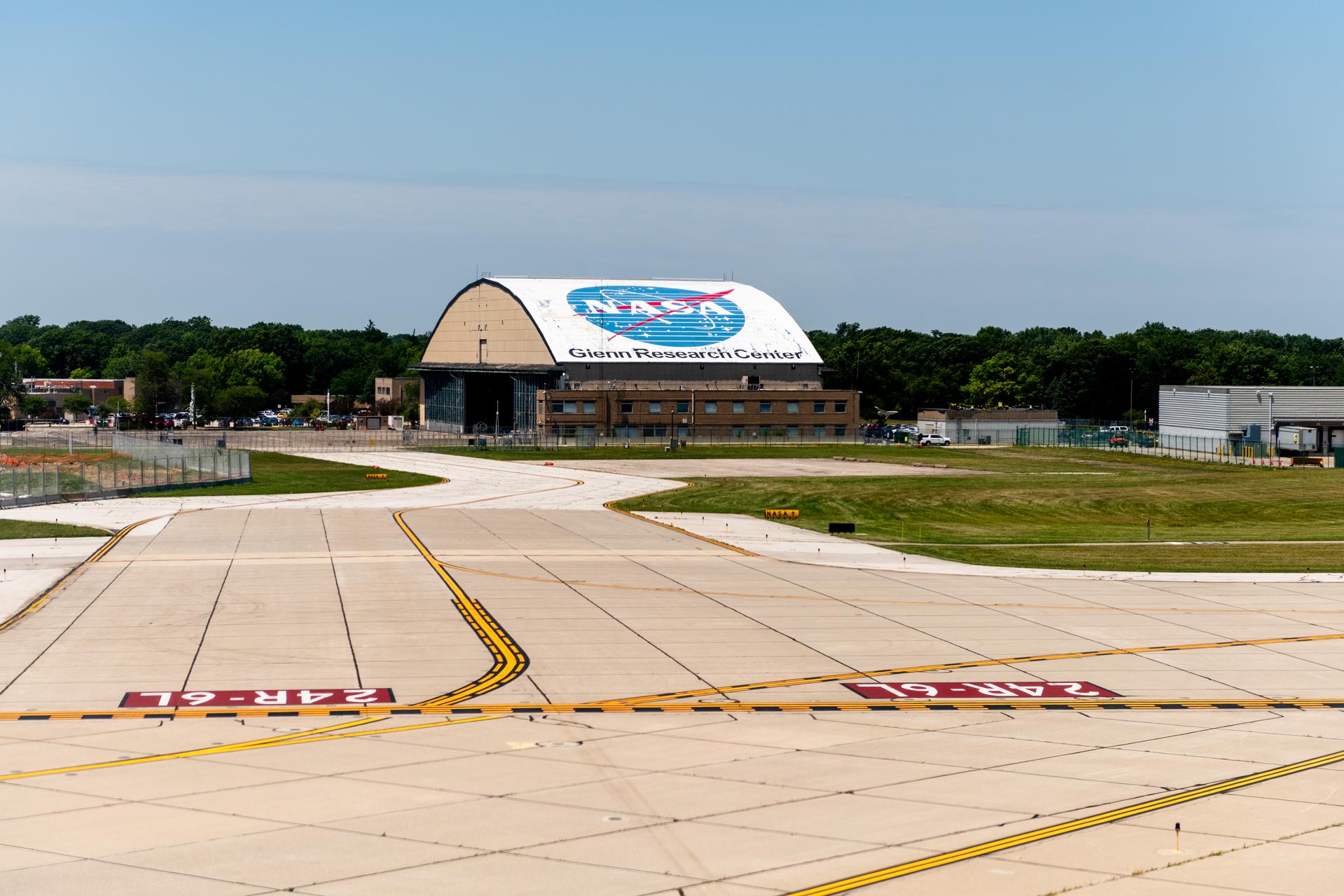
NASA Invites Proposals to Lease Aircraft Hangar in Cleveland
NASA’s Glenn Research Center in Cleveland is seeking proposals for the use of its historic aircraft hangar, along with a parking lot, tarmac, and a small neighboring office building. Proposals are due by 1 p.m. EDT on Nov. 28.
The hangar, formally known as the Flight Research Building, is available for lease by signing a National Historic Preservation Act agreement for a 10-year base period and two optional five-year extensions.
NASA first announced plans to lease the Flight Research Building and other facilities in May 2024 under the government’s Enhanced Use Lease authority. These lease agreements allow space, aeronautics, and other related industries to use agency land and facilities, reducing NASA’s maintenance costs while fostering strategic partnerships that spur innovation.
“Glenn is making great progress as we modernize our Cleveland and Sandusky campuses to support NASA’s future missions,” said Dr. Jimmy Kenyon, Glenn’s center director. “Through Enhanced Use Leases, we’re ensuring full use of land and facilities while preserving an iconic, historic building and creating regional economic opportunities.”
The property available for lease includes up to 6.7 acres of land, which contains the heated aircraft hangar, Operations and Integration Building, parking lot, and tarmac. The hangar is 160 feet by 280 feet, and the Operations and Integration Building is 5,947 square feet. Proceeds from this lease will be used to maintain Glenn facilities and infrastructure.
Visible from Brookpark Road and Cleveland Hopkins International Airport, Glenn’s hangar was the first building completed after the center was established in 1941. It has sheltered many unique aircraft used to perform vital research. From studying ice accumulation on aircraft wings to the first use of laser communications to stream 4K video from an aircraft to the International Space Station, Glenn flight research has contributed to aviation safety, atmospheric studies, and cutting-edge technology development.
Interested parties should contact both Carlos Flores at carlos.a.flores-1@nasa.gov and Diana Munro at diana.c.munro@nasa.gov to sign up for a walk-through from Monday, Sept. 8, to Friday, Sept. 12, or the week of Oct. 6.
For a 360-degree virtual tour of the Flight Research Building, visit:
https://www3.nasa.gov/specials/hangar360/
-end-
Jan Wittry
Glenn Research Center, Cleveland
216-433-5466
jan.m.wittry-1@nasa.gov
Missions
Humans in Space
Climate Change
Solar System
NASA Releases Opportunity to Boost Commercial Space Tech Development
5 min read
Preparations for Next Moonwalk Simulations Underway (and Underwater) Credit: NASANASA has released a new proposal opportunity for industry to tap into agency know-how, resources, and expertise. The Announcement of Collaboration Opportunity (ACO), managed by the Space Technology Mission Directorate, enables valuable collaboration without financial exchanges between NASA and industry partners. Instead, companies leverage NASA subject matter experts, facilities, software, and hardware to accelerate their technologies and prepare them for future commercial and government use.
On Wednesday, NASA issued a standing ACO announcement for partnership proposals which will be available for five years and will serve as the umbrella opportunity for topic-specific appendix releases. NASA intends to issue appendices every six to 12 months to address evolving space technology needs. The 2025 ACO appendix is open for proposals until Sept. 24.
NASA will host an informational webinar about the opportunity and appendix at 2 p.m. EDT on Wednesday, Aug. 6. Interested proposers are encouraged to submit questions which will be answered during the webinar and will be available online after the webinar.
NASA teaming with industry isn’t new – decades of partnerships have resulted in ambitious missions that benefit all of humanity. But in recent years, NASA has also played a key role as a technology enabler, providing one-of-a-kind tools, resources, and infrastructure to help commercial aerospace companies achieve their goals.
Since 2015, NASA has collaborated with industry on approximately 80 ACO projects. Here are some ways the collaborations have advanced space technology:
Lunar lander systemsBlue Origin and NASA worked together on several ACOs to mature the company’s lunar lander design. NASA provided technical reports and assessments and conducted tests at multiple centers to help Blue Origin advance a stacked fuel cell system for a lander’s primary power source. Other Blue Origin ACO projects evaluated high-temperature engine materials and advanced a landing navigation and guidance system.
Blue Origin’s Blue Moon Mark 1 (MK1) lander is delivering NASA science and technology to the Moon through the agency’s Commercial Lunar Payload Services initiative. In 2023, NASA selected Blue Origin as a Human Landing System provider to develop its Blue Moon MK2 lander for future crewed lunar exploration.
Artist concept of Blue Origin’s Blue Moon Mark 1 (MK1) lander.Credit: Blue Origin Cryogenic fluid transferThroughout a year-long ACO, NASA and SpaceX engineers worked together to perform in-depth computational fluid analysis of proposed propellant transfer methods between two SpaceX Starship spacecraft in low-Earth orbit. The SpaceX-specific analysis utilized Starship flight data and data from previous NASA research and development to identify potential risks and help mitigate them during the early stages of commercial development. NASA also provided inputs as SpaceX developed an initial concept of operations for its orbital propellant transfer missions.
SpaceX used the ACO analyses to inform the design of its Starship Human Landing System, which NASA selected in 2021 to put the first Artemis astronauts on the Moon.
This artist’s concept depicts a SpaceX Starship tanker (bottom) transferring propellant to a Starship depot (top) in low Earth orbit. Before astronauts launch in Orion atop the agency’s SLS (Space Launch System) rocket, SpaceX will launch a storage depot to Earth orbit. For the Artemis III and Artemis IV missions, SpaceX plans to complete propellant loading operations in Earth orbit to send a fully fueled Starship Human Landing System (HLS) to the Moon.Credit: SpaceX Autonomous spacecraft navigation solutionAdvanced Space and NASA partnered to advance the company’s Cislunar Autonomous Positioning System – software that allows lunar spacecraft to determine their location without relying exclusively on tracking from Earth.
Dylan Schmidt, CAPSTONE assembly integration and test lead, installs solar panels onto the CAPSTONE spacecraft at Tyvak Nano-Satellite Systems, Inc., in Irvine, California.NASA/Dominic HartThe CAPSTONE (Cislunar Autonomous Positioning System Technology Operations and Navigation Experiment) spacecraft launched to the Moon in 2022 and continues to operate and collect critical data to refine the software. Under the ACO, Advanced Space was able to use NASA’s Lunar Reconnaissance Orbiter to conduct crosslink experiments with CAPSTONE, helping mature the navigation solution for future missions. The mission’s Cislunar Autonomous Positioning System technology was initially supported through the NASA Small Business Innovation Research program.
Multi-purpose laser sensing systemSensuron and NASA matured a miniature, rugged fiber optic sensing system capable of taking thermal and shape measurements for multiple applications. Throughout the ACO, Sensuron benefitted from NASA’s expertise in fiber optics and electrical, mechanical, and system testing engineering to design, fabricate, and “shake and bake” its prototype laser.
Sensuron Ruggedized Fiber Optics Sensing System.SensuronSpace missions could use the technology to monitor cryogenic propellant levels and determine a fuel tank’s structural integrity throughout an extended mission. The laser technology also has medical applications on Earth, which ultimately resulted in the Sensuron spinoff company, The Shape Sensing Company.
Flexible lunar tiresIn 2023, Venturi Astrolab began work with NASA under an ACO to test its flexible lunar tire design. The company tapped into testing capabilities unique to NASA, including heat transfer to cold lunar soil, traction, and life testing. The data validated the performance of tire prototypes, helping ready the design to support future NASA missions.
In 2024, NASA selected three companies, including Venturi Astrolab, to advance capabilities for a lunar terrain vehicle that astronauts could use to travel around the lunar surface, conducting scientific research on the Moon and preparing for human missions to Mars.
Venturi Lab designed and developed a durable, robust, and hyper-deformable lunar wheel.Venturi LabThe Announcement of Collaboration Opportunity (ACO) is one of many ways NASA enables commercial industry to develop, build, own, and eventually operate space systems. To learn more about these technology projects and more, visit: https://techport.nasa.gov/.
Facebook logo @NASATechnology @NASA_Technology Explore More 2 min read NASA Seeks Industry Concepts on Moon, Mars Communications Article 1 week ago 1 min read USBR Seal Team Fix Challenge Article 1 week ago 4 min read NASA Tests New Heat Source Fuel for Deep Space Exploration Article 1 week ago Share Details Last Updated Jul 31, 2025 EditorJennifer M. Dooren Related TermsNASA Releases Opportunity to Boost Commercial Space Tech Development
5 min read
Preparations for Next Moonwalk Simulations Underway (and Underwater) Credit: NASANASA has released a new proposal opportunity for industry to tap into agency know-how, resources, and expertise. The Announcement of Collaboration Opportunity (ACO), managed by the Space Technology Mission Directorate, enables valuable collaboration without financial exchanges between NASA and industry partners. Instead, companies leverage NASA subject matter experts, facilities, software, and hardware to accelerate their technologies and prepare them for future commercial and government use.
On Wednesday, NASA issued a standing ACO announcement for partnership proposals which will be available for five years and will serve as the umbrella opportunity for topic-specific appendix releases. NASA intends to issue appendices every six to 12 months to address evolving space technology needs. The 2025 ACO appendix is open for proposals until Sept. 24.
NASA will host an informational webinar about the opportunity and appendix at 2 p.m. EDT on Wednesday, Aug. 6. Interested proposers are encouraged to submit questions which will be answered during the webinar and will be available online after the webinar.
NASA teaming with industry isn’t new – decades of partnerships have resulted in ambitious missions that benefit all of humanity. But in recent years, NASA has also played a key role as a technology enabler, providing one-of-a-kind tools, resources, and infrastructure to help commercial aerospace companies achieve their goals.
Since 2015, NASA has collaborated with industry on approximately 80 ACO projects. Here are some ways the collaborations have advanced space technology:
Lunar lander systemsBlue Origin and NASA worked together on several ACOs to mature the company’s lunar lander design. NASA provided technical reports and assessments and conducted tests at multiple centers to help Blue Origin advance a stacked fuel cell system for a lander’s primary power source. Other Blue Origin ACO projects evaluated high-temperature engine materials and advanced a landing navigation and guidance system.
Blue Origin’s Blue Moon Mark 1 (MK1) lander is delivering NASA science and technology to the Moon through the agency’s Commercial Lunar Payload Services initiative. In 2023, NASA selected Blue Origin as a Human Landing System provider to develop its Blue Moon MK2 lander for future crewed lunar exploration.
Artist concept of Blue Origin’s Blue Moon Mark 1 (MK1) lander.Credit: Blue Origin Cryogenic fluid transferThroughout a year-long ACO, NASA and SpaceX engineers worked together to perform in-depth computational fluid analysis of proposed propellant transfer methods between two SpaceX Starship spacecraft in low-Earth orbit. The SpaceX-specific analysis utilized Starship flight data and data from previous NASA research and development to identify potential risks and help mitigate them during the early stages of commercial development. NASA also provided inputs as SpaceX developed an initial concept of operations for its orbital propellant transfer missions.
SpaceX used the ACO analyses to inform the design of its Starship Human Landing System, which NASA selected in 2021 to put the first Artemis astronauts on the Moon.
This artist’s concept depicts a SpaceX Starship tanker (bottom) transferring propellant to a Starship depot (top) in low Earth orbit. Before astronauts launch in Orion atop the agency’s SLS (Space Launch System) rocket, SpaceX will launch a storage depot to Earth orbit. For the Artemis III and Artemis IV missions, SpaceX plans to complete propellant loading operations in Earth orbit to send a fully fueled Starship Human Landing System (HLS) to the Moon.Credit: SpaceX Autonomous spacecraft navigation solutionAdvanced Space and NASA partnered to advance the company’s Cislunar Autonomous Positioning System – software that allows lunar spacecraft to determine their location without relying exclusively on tracking from Earth.
Dylan Schmidt, CAPSTONE assembly integration and test lead, installs solar panels onto the CAPSTONE spacecraft at Tyvak Nano-Satellite Systems, Inc., in Irvine, California.NASA/Dominic HartThe CAPSTONE (Cislunar Autonomous Positioning System Technology Operations and Navigation Experiment) spacecraft launched to the Moon in 2022 and continues to operate and collect critical data to refine the software. Under the ACO, Advanced Space was able to use NASA’s Lunar Reconnaissance Orbiter to conduct crosslink experiments with CAPSTONE, helping mature the navigation solution for future missions. The mission’s Cislunar Autonomous Positioning System technology was initially supported through the NASA Small Business Innovation Research program.
Multi-purpose laser sensing systemSensuron and NASA matured a miniature, rugged fiber optic sensing system capable of taking thermal and shape measurements for multiple applications. Throughout the ACO, Sensuron benefitted from NASA’s expertise in fiber optics and electrical, mechanical, and system testing engineering to design, fabricate, and “shake and bake” its prototype laser.
Sensuron Ruggedized Fiber Optics Sensing System.SensuronSpace missions could use the technology to monitor cryogenic propellant levels and determine a fuel tank’s structural integrity throughout an extended mission. The laser technology also has medical applications on Earth, which ultimately resulted in the Sensuron spinoff company, The Shape Sensing Company.
Flexible lunar tiresIn 2023, Venturi Astrolab began work with NASA under an ACO to test its flexible lunar tire design. The company tapped into testing capabilities unique to NASA, including heat transfer to cold lunar soil, traction, and life testing. The data validated the performance of tire prototypes, helping ready the design to support future NASA missions.
In 2024, NASA selected three companies, including Venturi Astrolab, to advance capabilities for a lunar terrain vehicle that astronauts could use to travel around the lunar surface, conducting scientific research on the Moon and preparing for human missions to Mars.
Venturi Lab designed and developed a durable, robust, and hyper-deformable lunar wheel.Venturi LabThe Announcement of Collaboration Opportunity (ACO) is one of many ways NASA enables commercial industry to develop, build, own, and eventually operate space systems. To learn more about these technology projects and more, visit: https://techport.nasa.gov/.
Facebook logo @NASATechnology @NASA_Technology Explore More 2 min read NASA Seeks Industry Concepts on Moon, Mars Communications Article 1 week ago 1 min read USBR Seal Team Fix Challenge Article 1 week ago 4 min read NASA Tests New Heat Source Fuel for Deep Space Exploration Article 1 week ago Share Details Last Updated Jul 31, 2025 EditorJennifer M. Dooren Related TermsNASA Tests Epic Solution for Supersonic Parachute Deliveries
2 min read
Preparations for Next Moonwalk Simulations Underway (and Underwater)NASA/Lori Losey
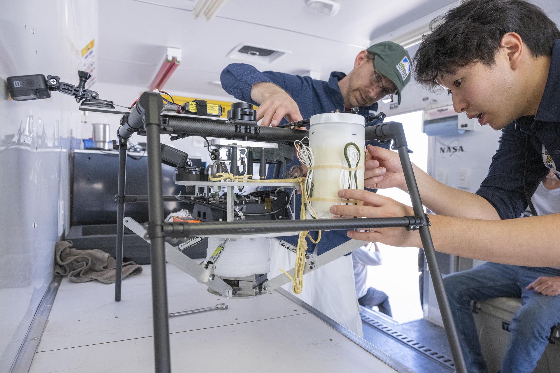
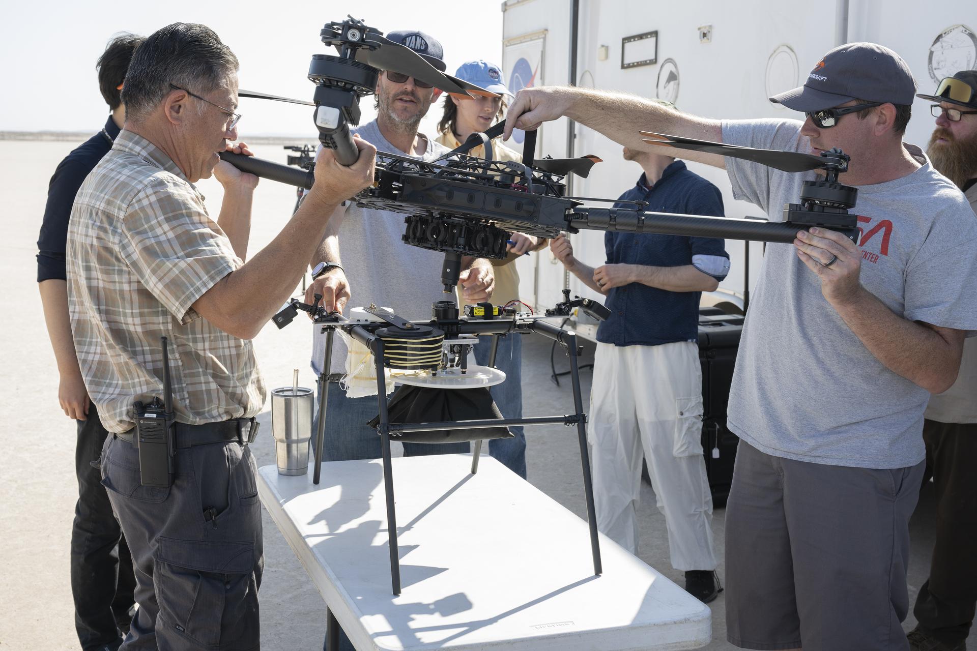
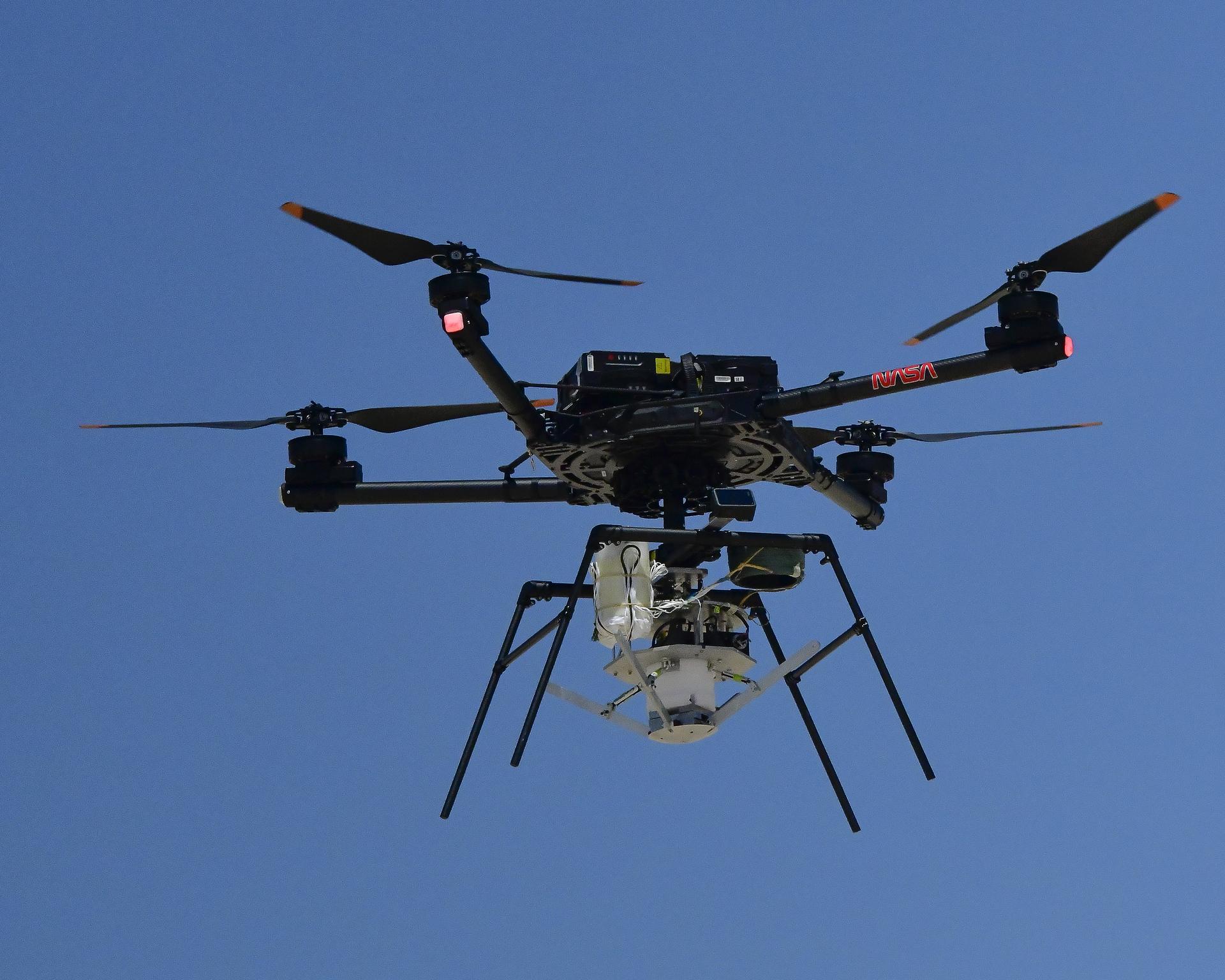
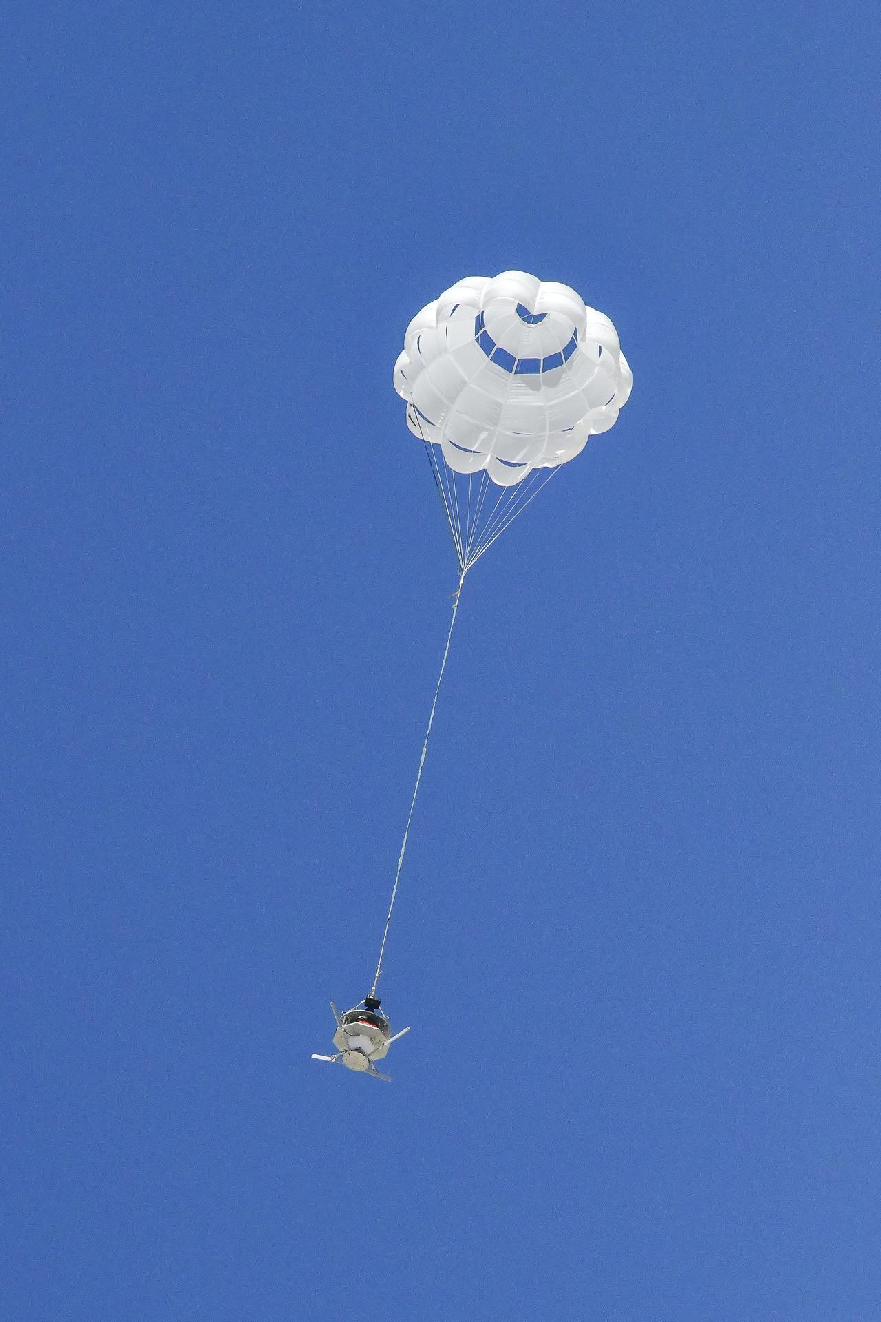
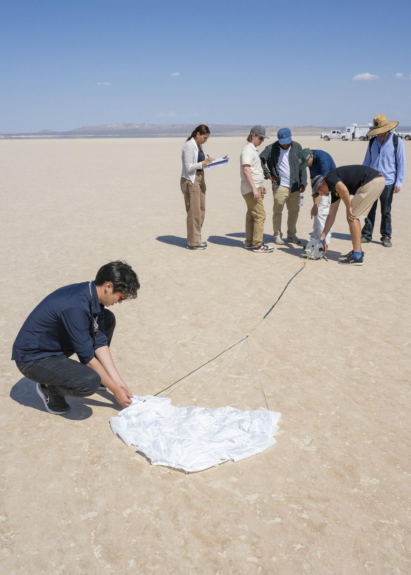
The best way to solve a mystery is by gathering evidence and building a case. That’s exactly what NASA researchers are doing with a series of research flights aimed at advancing a sensor for supersonic parachutes. The clues they find could help make these parachutes more reliable and safer for delivering scientific instruments and payloads to Mars.
These investigative research flights are led by the EPIC (Enhancing Parachutes by Instrumenting the Canopy) team at NASA’s Armstrong Fight Research Center in Edwards, California. During a June flight test, a quadrotor aircraft, or drone, air-launched a capsule that deployed a parachute equipped with a sensor. The flexible, strain-measuring sensor attached to the parachute did not interfere with the canopy material, just as the EPIC team had predicted. The sensors also provided data, a bonus for planning upcoming tests.
“Reviewing the research flights will help inform our next steps,” said Matt Kearns, project manager for EPIC at NASA Armstrong. “We are speaking with potential partners to come up with a framework to obtain the data that they are interested in pursuing. Our team members are developing methods for temperature testing the flexible sensors, data analysis, and looking into instrumentation for future tests.”
The flight tests were a first step toward filling gaps in computer models to improve supersonic parachutes. This work could also open the door to future partnerships, including with the aerospace and auto racing industries.
NASA’s Space Technology Mission Directorate (STMD) funds the EPIC work through its Entry Systems Modeling project at NASA’s Ames Research Center in California’s Silicon Valley. The capsule and parachute system were developed by NASA’s Langley Research Center in Hampton, Virginia. NASA Armstrong interns worked with Langley to build and integrate a similar system for testing at NASA Armstrong. An earlier phase of the work focused on finding commercially available flexible strain sensors and developing a bonding method as part of an STMD Early Career Initiative project.
NASA researchers Paul Bean, center, and Mark Hagiwara, right, attach the capsule with parachute system to the Enhancing Parachutes by Instrumenting the Canopy test experiment on June 4, 2025, at NASA’s Armstong Flight Research Center in Edwards, California. NASA researchers are developing technology to make supersonic parachutes safer and more reliable for delivering science instruments and payloads to Mars.NASA/Christopher LC Clark Derek Abramson, left, and Justin Link, right, attach an Alta X drone to the Enhancing Parachutes by Instrumenting the Canopy test experiment on June 4, 2025, at NASA’s Armstong Flight Research Center in Edwards, California. Abramson is NASA chief engineer at the center’s Dale Reed Subscale Flight Research Laboratory, where Link also works as a pilot for small uncrewed aircraft systems. NASA researchers are developing technology to make supersonic parachutes safer and more reliable for delivering science instruments and payloads to Mars.NASA/Christopher LC Clark An Alta X drone is positioned at altitude for an air launch of the Enhancing Parachutes by Instrumenting the Canopy test experiment on June 4, 2025, at NASA’s Armstong Flight Research Center in Edwards, California. NASA researchers are developing technology to make supersonic parachutes safer and more reliable for delivering science instruments and payloads to Mars.NASA/Christopher LC Clark The parachute of the Enhancing Parachutes by Instrumenting the Canopy test experiment deploys following an air launch from an Alta X drone on June 4, 2025, at NASA’s Armstong Flight Research Center in Edwards, California. NASA researchers are developing technology to make supersonic parachutes safer and more reliable for delivering science instruments and payloads to Mars.NASA/Christopher LC Clark The Enhancing Parachutes by Instrumenting the Canopy project team examines a capsule and parachute following an air launch from an Alta X drone on June 4, 2025, at NASA’s Armstong Flight Research Center in Edwards, California. NASA researchers are developing technology to make supersonic parachutes safer and more reliable for delivering science instruments and payloads to Mars.NASA/Christopher LC Clark Share Details Last Updated Jul 29, 2025 EditorDede DiniusContactJay Levinejay.levine-1@nasa.gov Related Terms Explore More 5 min read NASA Releases Opportunity to Boost Commercial Space Tech Development Article 1 day ago 3 min read NASA Drop Test Supports Safer Air Taxi Design and Certification Article 3 days ago 3 min read NASA Rehearses How to Measure X-59’s Noise Levels Article 6 days ago Keep Exploring Discover More Topics From NASAArmstrong Flight Research Center
Humans in Space
Climate Change
Solar System
NASA Tests Epic Solution for Supersonic Parachute Deliveries
2 min read
Preparations for Next Moonwalk Simulations Underway (and Underwater)NASA/Lori Losey
The best way to solve a mystery is by gathering evidence and building a case. That’s exactly what NASA researchers are doing with a series of research flights aimed at advancing a sensor for supersonic parachutes. The clues they find could help make these parachutes more reliable and safer for delivering scientific instruments and payloads to Mars.
These investigative research flights are led by the EPIC (Enhancing Parachutes by Instrumenting the Canopy) team at NASA’s Armstrong Fight Research Center in Edwards, California. During a June flight test, a quadrotor aircraft, or drone, air-launched a capsule that deployed a parachute equipped with a sensor. The flexible, strain-measuring sensor attached to the parachute did not interfere with the canopy material, just as the EPIC team had predicted. The sensors also provided data, a bonus for planning upcoming tests.
“Reviewing the research flights will help inform our next steps,” said Matt Kearns, project manager for EPIC at NASA Armstrong. “We are speaking with potential partners to come up with a framework to obtain the data that they are interested in pursuing. Our team members are developing methods for temperature testing the flexible sensors, data analysis, and looking into instrumentation for future tests.”
The flight tests were a first step toward filling gaps in computer models to improve supersonic parachutes. This work could also open the door to future partnerships, including with the aerospace and auto racing industries.
NASA’s Space Technology Mission Directorate (STMD) funds the EPIC work through its Entry Systems Modeling project at NASA’s Ames Research Center in California’s Silicon Valley. The capsule and parachute system were developed by NASA’s Langley Research Center in Hampton, Virginia. NASA Armstrong interns worked with Langley to build and integrate a similar system for testing at NASA Armstrong. An earlier phase of the work focused on finding commercially available flexible strain sensors and developing a bonding method as part of an STMD Early Career Initiative project.
NASA researchers Paul Bean, center, and Mark Hagiwara, right, attach the capsule with parachute system to the Enhancing Parachutes by Instrumenting the Canopy test experiment on June 4, 2025, at NASA’s Armstong Flight Research Center in Edwards, California. NASA researchers are developing technology to make supersonic parachutes safer and more reliable for delivering science instruments and payloads to Mars.NASA/Christopher LC Clark Derek Abramson, left, and Justin Link, right, attach an Alta X drone to the Enhancing Parachutes by Instrumenting the Canopy test experiment on June 4, 2025, at NASA’s Armstong Flight Research Center in Edwards, California. Abramson is NASA chief engineer at the center’s Dale Reed Subscale Flight Research Laboratory, where Link also works as a pilot for small uncrewed aircraft systems. NASA researchers are developing technology to make supersonic parachutes safer and more reliable for delivering science instruments and payloads to Mars.NASA/Christopher LC Clark An Alta X drone is positioned at altitude for an air launch of the Enhancing Parachutes by Instrumenting the Canopy test experiment on June 4, 2025, at NASA’s Armstong Flight Research Center in Edwards, California. NASA researchers are developing technology to make supersonic parachutes safer and more reliable for delivering science instruments and payloads to Mars.NASA/Christopher LC Clark The parachute of the Enhancing Parachutes by Instrumenting the Canopy test experiment deploys following an air launch from an Alta X drone on June 4, 2025, at NASA’s Armstong Flight Research Center in Edwards, California. NASA researchers are developing technology to make supersonic parachutes safer and more reliable for delivering science instruments and payloads to Mars.NASA/Christopher LC Clark The Enhancing Parachutes by Instrumenting the Canopy project team examines a capsule and parachute following an air launch from an Alta X drone on June 4, 2025, at NASA’s Armstong Flight Research Center in Edwards, California. NASA researchers are developing technology to make supersonic parachutes safer and more reliable for delivering science instruments and payloads to Mars.NASA/Christopher LC Clark Share Details Last Updated Jul 29, 2025 EditorDede DiniusContactJay Levinejay.levine-1@nasa.gov Related Terms Explore More 5 min read NASA Releases Opportunity to Boost Commercial Space Tech Development Article 1 day ago 3 min read NASA Drop Test Supports Safer Air Taxi Design and Certification Article 3 days ago 3 min read NASA Rehearses How to Measure X-59’s Noise Levels Article 6 days ago Keep Exploring Discover More Topics From NASAArmstrong Flight Research Center
Humans in Space
Climate Change
Solar System
NASA-ISRO Satellite Lifts Off to Track Earth’s Changing Surfaces
Editor’s Note: This release was edited on July 30, 2025, to correct the mission launch time in the IST time zone.
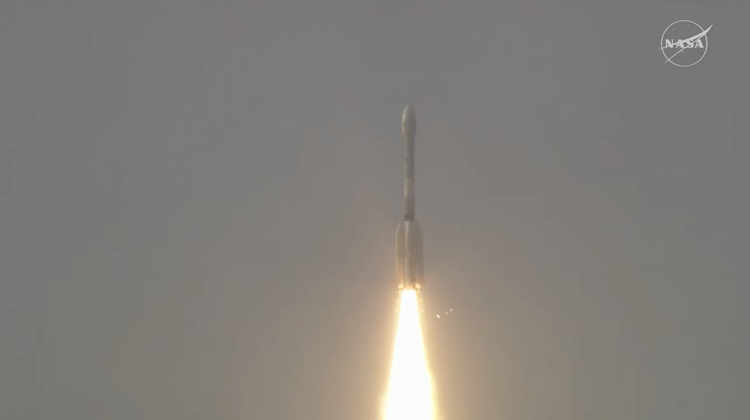
Carrying an advanced radar system that will produce a dynamic, three-dimensional view of Earth in unprecedented detail, the NISAR (NASA-ISRO Synthetic Aperture Radar) satellite has launched from Satish Dhawan Space Centre in Sriharikota, Andhra Pradesh, India.
Jointly developed by NASA and the Indian Space Research Organisation (ISRO), and a critical part of the United States – India civil-space cooperation highlighted by President Trump and Prime Minister Modi earlier this year, the satellite can detect the movement of land and ice surfaces down to the centimeter. The mission will help protect communities by providing unique, actionable information to decision-makers in a diverse range of areas, including disaster response, infrastructure monitoring, and agricultural management.
The satellite lifted off aboard an ISRO Geosynchronous Satellite Launch Vehicle (GSLV) rocket at 5:40 p.m. IST (8:10 a.m. EDT), Wednesday. The ISRO ground controllers began communicating with NISAR about 20 minutes after launch, at just after 8:29 a.m. EDT, and confirmed it is operating as expected.
“Congratulations to the entire NISAR mission team on a successful launch that spanned across multiple time zones and continents in the first-ever partnership between NASA and ISRO on a mission of this sheer magnitude,” said Nicky Fox, associate administrator, Science Mission Directorate at NASA Headquarters in Washington. “Where moments are most critical, NISAR’s data will help ensure the health and safety of those impacted on Earth, as well as the infrastructure that supports them, for the benefit of all.”
From 464 miles (747 kilometers) above Earth, NISAR will use two advanced radar instruments to track changes in Earth’s forests and wetland ecosystems, monitor deformation and motion of the planet’s frozen surfaces, and detect the movement of Earth’s crust down to fractions of an inch — a key measurement in understanding how the land surface moves before, during, and after earthquakes, volcanic eruptions, and landslides.
“ISRO’s GSLV has precisely injected NISAR satellite into the intended orbit, 747 kilometers. I am happy to inform that this is GSLV’s first mission to Sun-synchronous polar orbit. With this successful launch, we are at the threshold of fulfilling the immense scientific potential NASA and ISRO envisioned for the NISAR mission more than 10 years ago,” said ISRO Chairman V Narayanan. “The powerful capability of this radar mission will help us study Earth’s dynamic land and ice surfaces in greater detail than ever before.”
The mission’s two radars will monitor nearly all the planet’s land- and ice-covered surfaces twice every 12 days, including areas of the polar Southern Hemisphere rarely covered by other Earth-observing radar satellites. The data NISAR collects also can help researchers assess how forests, wetlands, agricultural areas, and permafrost change over time.
“Observations from NISAR will provide new knowledge and tangible benefits for communities both in the U.S. and around the world,” said Karen St. Germain, director, Earth Science division at NASA Headquarters. “This launch marks the beginning of a new way of seeing the surface of our planet so that we can understand and foresee natural disasters and other changes in our Earth system that affect lives and property.”
The NISAR satellite is the first free-flying space mission to feature two radar instruments — an L-band system and an S-band system. Each system is sensitive to features of different sizes and specializes in detecting certain attributes. The L-band radar excels at measuring soil moisture, forest biomass, and motion of land and ice surfaces, while S-band radar excels at monitoring agriculture, grassland ecosystems, and infrastructure movement.
Together, the radar instruments will enhance all of the satellite’s observations, making NISAR more capable than previous synthetic aperture radar missions. Unlike optical sensors, NISAR will be able to “see” through clouds, making it possible to monitor the surface during storms, as well as in darkness and light.
NASA’s Jet Propulsion Laboratory in Southern California provided the L-band radar, and ISRO’s Space Applications Centre in Ahmedabad developed the S-band radar. The NISAR mission marks the first time the two agencies have co-developed hardware for an Earth-observing mission.
“We’re proud of the international team behind this remarkable satellite. The mission’s measurements will be global but its applications deeply local, as people everywhere will use its data to plan for a resilient future,” said Dave Gallagher, director, NASA JPL, which manages the U.S. portion of the mission for NASA. “At its core is synthetic aperture radar, a technology pioneered at NASA JPL that enables us to study Earth night and day, through all kinds of weather.”
Including L-band and S-band radars on one satellite is an evolution in SAR airborne and space-based missions that, for NASA, started in 1978 with the launch of Seasat. In 2012, ISRO began launching SAR missions starting with Radar Imaging Satellite (RISAT-1), followed by RISAT-1A in 2022, to support a wide range of applications in India.
In the coming weeks, the spacecraft will begin a roughly 90-day commissioning phase during which it will deploy its 39-foot (12-meter) radar antenna reflector. This reflector will direct and receive microwave signals from the two radars. By interpreting the differences between the two, researchers can discern characteristics about the surface below. As NISAR passes over the same locations twice every 12 days, scientists can evaluate how those characteristics have changed over time to reveal new insights about Earth’s dynamic surfaces.
The NISAR mission is an equal collaboration between NASA and ISRO. Managed for the agency by Caltech, NASA JPL leads the U.S. component of the project and is providing the mission’s L-band SAR. NASA also is providing the radar reflector antenna, the deployable boom, a high-rate communication subsystem for science data, GPS receivers, a solid-state recorder, and payload data subsystem.
Space Applications Centre Ahmedabad, ISRO’s lead center for payload development, is providing the mission’s S-band SAR instrument and is responsible for its calibration, data processing, and development of science algorithms to address the scientific goals of the mission. U R Rao Satellite Centre in Bengaluru, which leads the ISRO components of the mission, is providing the spacecraft bus. The launch vehicle is from ISRO’s Vikram Sarabhai Space Centre, launch services are through ISRO’s Satish Dhawan Space Centre, and satellite operations are by ISRO Telemetry Tracking and Command Network. National Remote Sensing Centre in Hyderabad is responsible for S-band data reception, operational products generation, and dissemination.
To learn more about NISAR, visit:
-end-
Karen Fox / Elizabeth Vlock
Headquarters, Washington
202-358-1600
karen.c.fox@nasa.gov / elizabeth.a.vlock@nasa.gov
Andrew Wang / Jane J. Lee
Jet Propulsion Laboratory, Pasadena, Calif.
626-379-6874 / 818-354-0307
andrew.wang@jpl.nasa.gov / jane.j.lee@jpl.nasa.gov
NASA-ISRO Satellite Lifts Off to Track Earth’s Changing Surfaces
Editor’s Note: This release was edited on July 30, 2025, to correct the mission launch time in the IST time zone.
Carrying an advanced radar system that will produce a dynamic, three-dimensional view of Earth in unprecedented detail, the NISAR (NASA-ISRO Synthetic Aperture Radar) satellite has launched from Satish Dhawan Space Centre in Sriharikota, Andhra Pradesh, India.
Jointly developed by NASA and the Indian Space Research Organisation (ISRO), and a critical part of the United States – India civil-space cooperation highlighted by President Trump and Prime Minister Modi earlier this year, the satellite can detect the movement of land and ice surfaces down to the centimeter. The mission will help protect communities by providing unique, actionable information to decision-makers in a diverse range of areas, including disaster response, infrastructure monitoring, and agricultural management.
The satellite lifted off aboard an ISRO Geosynchronous Satellite Launch Vehicle (GSLV) rocket at 5:40 p.m. IST (8:10 a.m. EDT), Wednesday. The ISRO ground controllers began communicating with NISAR about 20 minutes after launch, at just after 8:29 a.m. EDT, and confirmed it is operating as expected.
“Congratulations to the entire NISAR mission team on a successful launch that spanned across multiple time zones and continents in the first-ever partnership between NASA and ISRO on a mission of this sheer magnitude,” said Nicky Fox, associate administrator, Science Mission Directorate at NASA Headquarters in Washington. “Where moments are most critical, NISAR’s data will help ensure the health and safety of those impacted on Earth, as well as the infrastructure that supports them, for the benefit of all.”
From 464 miles (747 kilometers) above Earth, NISAR will use two advanced radar instruments to track changes in Earth’s forests and wetland ecosystems, monitor deformation and motion of the planet’s frozen surfaces, and detect the movement of Earth’s crust down to fractions of an inch — a key measurement in understanding how the land surface moves before, during, and after earthquakes, volcanic eruptions, and landslides.
“ISRO’s GSLV has precisely injected NISAR satellite into the intended orbit, 747 kilometers. I am happy to inform that this is GSLV’s first mission to Sun-synchronous polar orbit. With this successful launch, we are at the threshold of fulfilling the immense scientific potential NASA and ISRO envisioned for the NISAR mission more than 10 years ago,” said ISRO Chairman V Narayanan. “The powerful capability of this radar mission will help us study Earth’s dynamic land and ice surfaces in greater detail than ever before.”
The mission’s two radars will monitor nearly all the planet’s land- and ice-covered surfaces twice every 12 days, including areas of the polar Southern Hemisphere rarely covered by other Earth-observing radar satellites. The data NISAR collects also can help researchers assess how forests, wetlands, agricultural areas, and permafrost change over time.
“Observations from NISAR will provide new knowledge and tangible benefits for communities both in the U.S. and around the world,” said Karen St. Germain, director, Earth Science division at NASA Headquarters. “This launch marks the beginning of a new way of seeing the surface of our planet so that we can understand and foresee natural disasters and other changes in our Earth system that affect lives and property.”
The NISAR satellite is the first free-flying space mission to feature two radar instruments — an L-band system and an S-band system. Each system is sensitive to features of different sizes and specializes in detecting certain attributes. The L-band radar excels at measuring soil moisture, forest biomass, and motion of land and ice surfaces, while S-band radar excels at monitoring agriculture, grassland ecosystems, and infrastructure movement.
Together, the radar instruments will enhance all of the satellite’s observations, making NISAR more capable than previous synthetic aperture radar missions. Unlike optical sensors, NISAR will be able to “see” through clouds, making it possible to monitor the surface during storms, as well as in darkness and light.
NASA’s Jet Propulsion Laboratory in Southern California provided the L-band radar, and ISRO’s Space Applications Centre in Ahmedabad developed the S-band radar. The NISAR mission marks the first time the two agencies have co-developed hardware for an Earth-observing mission.
“We’re proud of the international team behind this remarkable satellite. The mission’s measurements will be global but its applications deeply local, as people everywhere will use its data to plan for a resilient future,” said Dave Gallagher, director, NASA JPL, which manages the U.S. portion of the mission for NASA. “At its core is synthetic aperture radar, a technology pioneered at NASA JPL that enables us to study Earth night and day, through all kinds of weather.”
Including L-band and S-band radars on one satellite is an evolution in SAR airborne and space-based missions that, for NASA, started in 1978 with the launch of Seasat. In 2012, ISRO began launching SAR missions starting with Radar Imaging Satellite (RISAT-1), followed by RISAT-1A in 2022, to support a wide range of applications in India.
In the coming weeks, the spacecraft will begin a roughly 90-day commissioning phase during which it will deploy its 39-foot (12-meter) radar antenna reflector. This reflector will direct and receive microwave signals from the two radars. By interpreting the differences between the two, researchers can discern characteristics about the surface below. As NISAR passes over the same locations twice every 12 days, scientists can evaluate how those characteristics have changed over time to reveal new insights about Earth’s dynamic surfaces.
The NISAR mission is an equal collaboration between NASA and ISRO. Managed for the agency by Caltech, NASA JPL leads the U.S. component of the project and is providing the mission’s L-band SAR. NASA also is providing the radar reflector antenna, the deployable boom, a high-rate communication subsystem for science data, GPS receivers, a solid-state recorder, and payload data subsystem.
Space Applications Centre Ahmedabad, ISRO’s lead center for payload development, is providing the mission’s S-band SAR instrument and is responsible for its calibration, data processing, and development of science algorithms to address the scientific goals of the mission. U R Rao Satellite Centre in Bengaluru, which leads the ISRO components of the mission, is providing the spacecraft bus. The launch vehicle is from ISRO’s Vikram Sarabhai Space Centre, launch services are through ISRO’s Satish Dhawan Space Centre, and satellite operations are by ISRO Telemetry Tracking and Command Network. National Remote Sensing Centre in Hyderabad is responsible for S-band data reception, operational products generation, and dissemination.
To learn more about NISAR, visit:
-end-
Karen Fox / Elizabeth Vlock
Headquarters, Washington
202-358-1600
karen.c.fox@nasa.gov / elizabeth.a.vlock@nasa.gov
Andrew Wang / Jane J. Lee
Jet Propulsion Laboratory, Pasadena, Calif.
626-379-6874 / 818-354-0307
andrew.wang@jpl.nasa.gov / jane.j.lee@jpl.nasa.gov
