
NASA
NASA’s Webb Telescope Studies Moon-Forming Disk Around Massive Planet
- Webb
- News
- Overview
- Science
- Observatory
- Multimedia
- Team
- More
Illustration: NASA, ESA, CSA, STScI, Gabriele Cugno (University of Zürich, NCCR PlanetS), Sierra Grant (Carnegie Institution for Science), Joseph Olmsted (STScI), Leah Hustak (STScI)
NASA’s James Webb Space Telescope has provided the first direct measurements of the chemical and physical properties of a potential moon-forming disk encircling a large exoplanet. The carbon-rich disk surrounding the world called CT Cha b, which is located 625 light-years away from Earth, is a possible construction yard for moons, although no moons are detected in the Webb data.
The results published today in The Astrophysical Journal Letters.
The young star the planet orbits is only 2 million years old and still accreting circumstellar material. However, the circumplanetary disk discovered by Webb is not part of the larger accretion disk around the central star. The two objects are 46 billion miles apart.
Observing planet and moon formation is fundamental to understanding the evolution of planetary systems across our galaxy. Moons likely outnumber planets, and some might be habitats for life as we know it. But we are only now entering an era where we can witness their formation.
This discovery fosters a better understanding of planet and moon formation, say researchers. Webb’s data is invaluable for making comparisons to our solar system’s birth over 4 billion years ago.
“We can see evidence of the disk around the companion, and we can study the chemistry for the first time. We’re not just witnessing moon formation — we’re also witnessing this planet’s formation,” said co-lead author Sierra Grant of the Carnegie Institution for Science in Washington.
“We are seeing what material is accreting to build the planet and moons,” added main lead author Gabriele Cugno of the University of Zürich and member of the National Center of Competence in Research PlanetS.
Image A: Circumplanetary Disk (Artist’s Concept) An artistic rendering of a dust and gas disk encircling the young exoplanet, CT Cha b, 625 light-years from Earth. Spectroscopic data from NASA’s James Webb Space Telescope suggests the disk contains the raw materials for moon formation: diacetylene, hydrogen cyanide, propyne, acetylene, ethane, carbon dioxide, and benzene. The planet appears at lower right, while its host star and surrounding circumstellar disk are visible in the background. Illustration: NASA, ESA, CSA, STScI, Gabriele Cugno (University of Zürich, NCCR PlanetS), Sierra Grant (Carnegie Institution for Science), Joseph Olmsted (STScI), Leah Hustak (STScI) Dissecting starlightInfrared observations of CT Cha b were made with Webb’s MIRI (Mid-Infrared Instrument) using its medium resolution spectrograph. An initial look into Webb’s archival data revealed signs of molecules within the circumplanetary disk, which motivated a deeper dive into the data. Because the planet’s faint signal is buried in the glare of the host star, the researchers had to disentangle the light of the star from the planet using high-contrast methods.
“We saw molecules at the location of the planet, and so we knew that there was stuff in there worth digging for and spending a year trying to tease out of the data. It really took a lot of perseverance,” said Grant.
Ultimately, the team discovered seven carbon-bearing molecules within the planet’s disk, including acetylene (C2H2) and benzene (C6H6). This carbon-rich chemistry is in stark contrast to the chemistry seen in the disk around the host star, where the researchers found water but no carbon. The difference between the two disks offers evidence for their rapid chemical evolution over only than 2 million years.
Genesis of moonsA circumplanetary disk has long been hypothesized as the birthplace of Jupiter’s four major moons. These Galilean satellites must have condensed out of such a flattened disk billions of years ago, as evident in their co-planar orbits about Jupiter. The two outermost Galilean moons, Ganymede and Callisto, are 50% water ice. But they presumably have rocky cores, perhaps either of carbon or silicon.
“We want to learn more about how our solar system formed moons. This means that we need to look at other systems that are still under construction. We’re trying to understand how it all works,” said Cugno. “How do these moons come to be? What are their ingredients? What physical processes are at play, and over what timescales? Webb allows us to witness the drama of moon formation and investigate these questions observationally for the first time.”
In the coming year, the team will use Webb to perform a comprehensive survey of similar objects, to better understand the diversity of physical and chemical properties in the disks around young planets.
The James Webb Space Telescope is the world’s premier space science observatory. Webb is solving mysteries in our solar system, looking beyond to distant worlds around other stars, and probing the mysterious structures and origins of our universe and our place in it. Webb is an international program led by NASA with its partners, ESA (European Space Agency) and CSA (Canadian Space Agency).
To learn more about Webb, visit:
Related InformationRead more: NASA’s Webb Finds Planet-Forming Disks Lived Longer in Early Universe
Explore more: ViewSpace Detecting Other Worlds: Direct Imaging
Explore more: How to Study Exoplanets: Webb and Challenges
Read more: Webb’s Star Formation Discoveries
Related For Kids Share Details Last Updated Sep 29, 2025 Editor Marty McCoy Contact Laura Betz laura.e.betz@nasa.gov Related Terms Keep Exploring Related Topics James Webb Space TelescopeSpace Telescope
Exoplanets
Exoplanet Stories
Universe
From City Lights to Moonlight: NASA Training Shows How Urban Parks Can Connect Communities with Space Science
4 min read
From City Lights to Moonlight: NASA Training Shows How Urban Parks Can Connect Communities with Space ScienceWhen you think about national park and public land astronomy programs, you might picture remote locations far from city lights. But a recent NASA Earth to Sky training, funded by NASA’s Science Activation Program, challenges that assumption, demonstrating how urban parks, wildlife refuges, museums, and green spaces can be incredible venues for connecting communities with space science. Programs facilitated in urban spaces can reach people where they already live, work, and recreate. This creates opportunities for ongoing engagement as urban astronomy program participants can discover that the skies above their neighborhoods hold the same wonders as remote locations.
During the first week of August in 2025, NASA Earth to Sky collaborated with the National Park Service and U.S. Fish and Wildlife Service to deliver an innovative astronomy training program called “Rivers of Stars and Stories: Interpreting the Northern Night Sky” at Minnesota Valley National Wildlife Refuge in Minneapolis-St. Paul. This three-day course brought together 28 park ranger interpreters, environmental educators, and outdoor communicators from across the Twin Cities area. Presentations and discussions centered around engaging urban audiences with the wonders of space science by leveraging the benefits of metropolitan spaces and the unique opportunities that city skies provide.
Throughout this immersive training, participants explored everything from lunar observations and aurora science to NASA’s Artemis Program and astrobiology. The training empowered participants by affirming that everyone is an effective stargazer and night sky storyteller, transforming beginners into confident astronomy communicators. One participant captured their experience by noting they went from “not knowing much of anything to having a much better grasp on basic concepts and most importantly, where to find more resources!” In addition to sharing resources, this training also launched a community of practice where communicators can continue to collaborate. Participants engaged in discussions on how to respectfully incorporate the local indigenous perspectives into astronomy programming and honor the traditional stewards of the land while avoiding appropriation or misrepresentation of indigenous science.
The course also created a lasting community connection to NASA through presentations by NASA experts and demonstrations of NASA activity toolkits. As one participant noted in the evaluation, “This is just the start of a long learning journey, but I know now where to look and how to find answers.” Toolkits and resources shared included GLOBE (Global Learning & Observation to Benefit the Environment) Observer’s NUBE (cloud) game, Our Dynamic Sun by the NASA Heliophysics Education Activation Team (HEAT) and the Night Sky Network, the Aurorasaurus Citizen Science project, and the local Solar System Ambassador Network.
Participants’ sense of belonging to the Earth to Sky community increased dramatically. These outcomes support NASA’s strategic goal of building sustained public engagement with Earth and space science. The overwhelmingly positive feedback, with 100% of participants expressing interest in taking more courses like this, demonstrates the tremendous value it is for Earth to Sky to collaborate with the National Park Service and US Fish and Wildlife Service, as all agencies’ public communication goals are addressed.
This kind of collaborative work is crucial because it builds a network of science communicators who can reach thousands of visitors across Minneapolis-St. Paul’s parks, nature centers, and outdoor spaces. By training local informal educators to confidently share NASA’s discoveries and missions, the program expands access to space science for urban audiences throughout the Twin Cities region.
The Earth to Sky team will continue fostering these valuable partnerships with the National Park Service and U.S. Fish and Wildlife Service, as well as other state and local agencies and nonprofit organizations. Learn more about Earth to Sky’s work with park interpreters and nonformal educators to share NASA space science by visiting: https://science.nasa.gov/sciact-team/earth-to-sky/
Learn more about how Science Activation connects NASA science experts, real content, and experiences with community leaders to do science in ways that activate minds and promote deeper understanding of our world and beyond: https://science.nasa.gov/learn/about-science-activation/.
Participants of the “Rivers of Stars and Stories: Interpreting the Northern Night Sky” training model moon phases outside of the Minnesota Valley National Wildlife Refuge Education Center. NASA Earth to Sky Share Details Last Updated Sep 26, 2025 Editor NASA Science Editorial Team Related Terms Explore More 3 min read NASA Helps Connect Astronomers and Community Colleges Across the NationArticle
4 hours ago 2 min read NASA & STEM Learning Ecosystems: Opportunities & Benefits for Everyone
Article
1 day ago 3 min read Educators Incorporate Locally-Relevant NASA Earth Data to Build Data Literacy in the Classroom
Article
1 week ago Keep Exploring Discover More Topics From NASA James Webb Space Telescope
Webb is the premier observatory of the next decade, serving thousands of astronomers worldwide. It studies every phase in the…
Perseverance RoverThis rover and its aerial sidekick were assigned to study the geology of Mars and seek signs of ancient microbial…
Parker Solar ProbeOn a mission to “touch the Sun,” NASA’s Parker Solar Probe became the first spacecraft to fly through the corona…
JunoNASA’s Juno spacecraft entered orbit around Jupiter in 2016, the first explorer to peer below the planet’s dense clouds to…
NASA Awards Custodial, Landscaping Services Contract
NASA has selected Melwood Horticultural Training Center Inc. of Upper Marlboro, Maryland, to provide custodial, janitorial, landscaping, and recycling services for the agency’s Goddard Space Flight Center in Greenbelt, Maryland.
The Facilities Custodial and Landscaping award is a firm-fixed-price hybrid completion and indefinite-delivery/indefinite-quantity contract. The contract includes one 12-month base period and up to four 12-month options with a potential contract value of approximately $36 million if all options are exercised. The basic period of performance begins Wednesday, Oct. 1, 2025, and ends Sept. 30, 2026. The four option periods, if exercised, would extend the contract through Sept. 30, 2030.
For information about NASA and agency programs, visit:
-end-
Robert Garner
Goddard Space Flight Center, Greenbelt, Md.
301-286-5687
rob.garner@nasa.gov
NASA Helps Connect Astronomers and Community Colleges Across the Nation
3 min read
NASA Helps Connect Astronomers and Community Colleges Across the NationThe NASA Community College Network (NCCN) and the American Astronomical Society (AAS) have teamed up to provide an exciting and impactful program that brings top astronomy researchers into the classrooms of community colleges around the United States.
The Harlow Shapley Visiting Lectureship Program, named for astronomer Harlow Shapley (1885-1972), has a history dating back to the 1950s, when it provided support for a scientist to give a series of astronomy-themed lectures at a college or university, coupled with a public talk to the local community. In 2024, AAS partnered with NCCN to broaden the impact of the Shapley lectureship program to community colleges, making use of NCCN’s existing network of 260 college instructors across 44 states and 120 participating Subject Matter Experts (SME) to “matchmake” community colleges with astronomers.
NCCN has supported the teaching of astronomy at community college since 2020. Community colleges serve a vital role in STEM education, with one-third of their students being first-generation college attendees and 64% being part-time students working jobs and raising families. Factor in that up to 40% of students taking introductory astronomy courses nationally each year do so at a community college, and the motivation behind NCCN and the initiatives of the AAS become clear.
In 2024, the pilot collaboration between NCCN and the AAS matched two community colleges — Chattanooga State Community College in Tennessee and Modesto Junior College in California — with SMEs from University of Virginia and Stanford University. In 2025, nine NCCN subject matter experts are engaging with 14 community colleges in six states. They are:
Joe Masiero (Caltech) at Grossmont Community College CA
Vivian U (Caltech) at Scottsdale & Chandler Gilbert Community Colleges AZ
Dave Leisawitz (NASA) & Michael Foley (Harvard) at Elgin Community College IL
Michael Rutkowski (MN State) at Dallas Area Colleges (five colleges) TX
Joe Masiero (Caltech) at Mt. San Jacinto College, Menifee Campus CA
Quyen Hart (STScI) at Casper College WY
Nathan McGregor (UCSC) at Yakima Valley College WA
Patrick Miller (Hardin-Simmons) at Evergreen Valley College CA
Kim Arcand (Harvard-Smithsonian) at Anne Arundel Community College MD
Natasha Batalha (NASA) at Modesto Junior College CA
Each visit of an AAS Shapley Lecturer is unique. The center of each event is the public Shapley Lecture, which is broadly advertised to the local community. Beyond the Shapley Lecture itself, host institutions organize a variety of local engagement activities – ranging from star parties and classroom visits to meeting with college deans and faculty – to make the most of their time with the Shapley Lecturer.
Astronomy instructor James Espinosa from Weatherford College said, “[The visiting Shapley Lecturer’s] visit made a permanent change in how my classes will be taught, in the sense that ‘honors’ projects will be available for ambitious students. I intend to keep in touch with him for several years to come, which is a big impact for our present and future students.”
Dr. Tom Rice, AAS Education Program Manager and AAS lead on the partnership with NCCN, stated, “The AAS’s Harlow Shapley Visiting Lectureship Program represents one of the most impactful ways that astronomers can share our scientific understanding with the widest possible audience, and I am very proud that we have partnered with the SETI Institute and NASA to bring astronomers to their network of community colleges.”
NCCN is supported by NASA under cooperative agreement award number 80NSSC21M0009 and is part of NASA’s Science Activation Portfolio. Learn more about how Science Activation connects NASA science experts, real content, and experiences with community leaders to do science in ways that activate minds and promote deeper understanding of our world and beyond: https://science.nasa.gov/learn/about-science-activation/.
Shapley Lecturers in action. Share Details Last Updated Sep 26, 2025 Editor NASA Science Editorial Team Related Terms Explore More 2 min read Hubble Captures Puzzling GalaxyArticle
7 hours ago 2 min read NASA & STEM Learning Ecosystems: Opportunities & Benefits for Everyone
Article
1 day ago 1 min read Help Map the Moon’s Molten Flows!
Article
2 days ago Keep Exploring Discover More Topics From NASA James Webb Space Telescope
Webb is the premier observatory of the next decade, serving thousands of astronomers worldwide. It studies every phase in the…
Perseverance RoverThis rover and its aerial sidekick were assigned to study the geology of Mars and seek signs of ancient microbial…
Parker Solar ProbeOn a mission to “touch the Sun,” NASA’s Parker Solar Probe became the first spacecraft to fly through the corona…
JunoNASA’s Juno spacecraft entered orbit around Jupiter in 2016, the first explorer to peer below the planet’s dense clouds to…
Lunar Challenge Winner Tests Technology in NASA Thermal Vacuum Chamber
By Savannah Bullard
One year after winning second place in NASA’s Break the Ice Lunar Challenge, members of the small business Starpath visited NASA’s Marshall Space Flight Center in Huntsville, Alabama, as part of their prize opportunity to test their upgraded lunar regolith excavation and transportation rover in the center’s 20-foot thermal vacuum chamber.
The technology startup headquartered in Hawthorne, California, won second place overall at the Break the Ice Lunar Challenge’s live demonstration and finale in June 2024. This competition, one of NASA’s Centennial Challenges, tasked competitors to design, build, and demonstrate robotic technologies that could excavate and transport the icy, rocky dirt – otherwise known as regolith – found on the Moon.
Starpath team members (foreground: Josh Kavilaveettil, mechanical engineer; background: Aakash Ramachandran, lead rover engineer) put their upgraded lunar regolith rover to the test inside NASA Marshall’s 20-foot thermal vacuum chamber – a prize opportunity marking one year since their 2nd place win in the Break the Ice Lunar Challenge.NASA/Joe Kuner“NASA’s Centennial Challenges are a great way to discover new, innovative technologies, including those for future use on the Moon and even Mars,” said Naveen Vetcha, Break the Ice Lunar Challenge manager at NASA Marshall. “Working with winners after the challenge concludes is a perfect example of how we can use NASA facilities to continue advancing these technologies to generate valuable solutions for the agency and industry.”
Starpath built a four-wheeled rover capable of excavating, collecting, and hauling material under extremely harsh environmental conditions that simulate the lunar South Pole. On the rover, a dual drum barrel can extend from the body of the robot – mimicking a movement similar to a crab’s claws – and scrape into rough, hard regolith to excavate material quickly without compromising finite battery life.
Before Starpath made the 2,000-mile drive from California to Alabama this summer, NASA Marshall’s Engineering Test Facility staff prepared a concrete slab outfitted with rocky terrain to act as a testbed for the robot to interact inside the chamber. The V-20 Thermal Vacuum Chamber, located at Marshall’s Environmental Test Facility, can simulate harsh environments by manipulating the chamber’s vacuum, temperature, humidity, and pressure effects. Starpath staff spent about three days at NASA Marshall in August, testing their robot with excavation and mobility trials while collecting data on its performance.
The Starpath team is honing the development of its technology for missions located at the permanently shadowed regions of the lunar South Pole. As a future landing site for NASA’s Artemis missions, which will send astronauts to the Moon and prepare to send the first Americans to Mars, the South Pole region of the Moon is known to contain ice within its regolith. This was the leading inspiration behind the development of the Break the Ice Lunar Challenge, as NASA will require robust technologies that can excavate and transport lunar ice for extraction, purification, and use as drinking water or rocket fuel.
Starpath, one of three winning teams in NASA’s Break the Ice Lunar Challenge, was invited by NASA Centennial Challenges to test their lunar excavation and traversal rover at the agency’s thermal vacuum chamber facility at NASA’s Marshall Space Flight Center in Huntsville, Alabama. The invitation was an added perk to the team’s successful participation in Break the Ice, which took place from 2020 to 2024. A space hardware startup from Hawthorne, California, Starpath won a cumulative $838,461 across three levels of Phase 2 before winning second place overall at the challenge’s live demonstration and finale in June 2024. In this image, two members of the Starpath team remotely operate the rover and run data in preparation for its entrance to the V20 Thermal Vacuum Chamber. NASA/Joe Kuner Starpath, one of three winning teams in NASA’s Break the Ice Lunar Challenge, was invited by NASA Centennial Challenges to test their lunar excavation and traversal rover at the agency’s thermal vacuum chamber facility at NASA’s Marshall Space Flight Center in Huntsville, Alabama. The invitation was an added perk to the team’s successful participation in Break the Ice, which took place from 2020 to 2024. A space hardware startup from Hawthorne, California, Starpath won a cumulative $838,461 across three levels of Phase 2 before winning second place overall at the challenge’s live demonstration and finale in June 2024. In this image, employees from NASA Marshall’s Environmental Test Facility work with the Starpath team to carefully maneuver the rover onto a platform that will slide the rover into the chamber. NASA/Joe Kuner Starpath, one of three winning teams in NASA’s Break the Ice Lunar Challenge, was invited by NASA Centennial Challenges to test their lunar excavation and traversal rover at the agency’s thermal vacuum chamber facility at NASA’s Marshall Space Flight Center in Huntsville, Alabama. The invitation was an added perk to the team’s successful participation in Break the Ice, which took place from 2020 to 2024. A space hardware startup from Hawthorne, California, Starpath won a cumulative $838,461 across three levels of Phase 2 before winning second place overall at the challenge’s live demonstration and finale in June 2024. In this image, employees from NASA Marshall’s Environmental Test Facility situate the rover over the concrete slab that it will operate on before removing the suspension straps that lifted it onto the platform. NASA/Joe Kuner Starpath, one of three winning teams in NASA’s Break the Ice Lunar Challenge, was invited by NASA Centennial Challenges to test their lunar excavation and traversal rover at the agency’s thermal vacuum chamber facility at NASA’s Marshall Space Flight Center in Huntsville, Alabama. The invitation was an added perk to the team’s successful participation in Break the Ice, which took place from 2020 to 2024. A space hardware startup from Hawthorne, California, Starpath won a cumulative $838,461 across three levels of Phase 2 before winning second place overall at the challenge’s live demonstration and finale in June 2024. In this image, the rover finally freely rests on its concrete slab at the end of the platform. The large metal structure will slide into the chamber, bringing the rover and concrete slab with it. NASA/Joe Kuner Starpath, one of three winning teams in NASA’s Break the Ice Lunar Challenge, was invited by NASA Centennial Challenges to test their lunar excavation and traversal rover at the agency’s thermal vacuum chamber facility at NASA’s Marshall Space Flight Center in Huntsville, Alabama. The invitation was an added perk to the team’s successful participation in Break the Ice, which took place from 2020 to 2024. A space hardware startup from Hawthorne, California, Starpath won a cumulative $838,461 across three levels of Phase 2 before winning second place overall at the challenge’s live demonstration and finale in June 2024. In this image, NASA Environmental Test Facility employees work with members from the Starpath team to push the sliding platform into the thermal vacuum chamber, with the heavy rover and concrete slab in tow. NASA/Joe Kuner Starpath, one of three winning teams in NASA’s Break the Ice Lunar Challenge, was invited by NASA Centennial Challenges to test their lunar excavation and traversal rover at the agency’s thermal vacuum chamber facility at NASA’s Marshall Space Flight Center in Huntsville, Alabama. The invitation was an added perk to the team’s successful participation in Break the Ice, which took place from 2020 to 2024. A space hardware startup from Hawthorne, California, Starpath won a cumulative $838,461 across three levels of Phase 2 before winning second place overall at the challenge’s live demonstration and finale in June 2024. In this image, the large concrete platform is fully slid into the vacuum chamber, and members from the Starpath team discuss what final preparations need to be made before the chamber is closed.NASA/Joe Kuner Starpath, one of three winning teams in NASA’s Break the Ice Lunar Challenge, was invited by NASA Centennial Challenges to test their lunar excavation and traversal rover at the agency’s thermal vacuum chamber facility at NASA’s Marshall Space Flight Center in Huntsville, Alabama. The invitation was an added perk to the team’s successful participation in Break the Ice, which took place from 2020 to 2024. A space hardware startup from Hawthorne, California, Starpath won a cumulative $838,461 across three levels of Phase 2 before winning second place overall at the challenge’s live demonstration and finale in June 2024. In this image, the rover sits on a concrete slab that will be used to mimic the rugged lunar surface. The slab features a sandy, rocky terrain, and lamps within the chamber will turn on and off to simulate sunlight.NASA/Joe Kuner Starpath, one of three winning teams in NASA’s Break the Ice Lunar Challenge, was invited by NASA Centennial Challenges to test their lunar excavation and traversal rover at the agency’s thermal vacuum chamber facility at NASA’s Marshall Space Flight Center in Huntsville, Alabama. The invitation was an added perk to the team’s successful participation in Break the Ice, which took place from 2020 to 2024. A space hardware startup from Hawthorne, California, Starpath won a cumulative $838,461 across three levels of Phase 2 before winning second place overall at the challenge’s live demonstration and finale in June 2024. In this image, Starpath mechanical engineer Josh Kavilaveettil monitors a component of the rover, attached to wires, in preparation for testing.NASA/Joe Kuner Starpath, one of three winning teams in NASA’s Break the Ice Lunar Challenge, was invited by NASA Centennial Challenges to test their lunar excavation and traversal rover at the agency’s thermal vacuum chamber facility at NASA’s Marshall Space Flight Center in Huntsville, Alabama. The invitation was an added perk to the team’s successful participation in Break the Ice, which took place from 2020 to 2024. A space hardware startup from Hawthorne, California, Starpath won a cumulative $838,461 across three levels of Phase 2 before winning second place overall at the challenge’s live demonstration and finale in June 2024. In this image, the rover sits atop its concrete slab at the mouth of the thermal vacuum chamber, ready to be closed in and commence testing.NASA/Joe KunerNASA’s Break the Ice Lunar Challenge was a NASA Centennial Challenge that ran from 2020 to 2024. The challenge was led by the agency’s Marshall Space Flight Center with support from NASA’s Kennedy Space Center in Florida. Centennial Challenges are part of the Prizes, Challenges, and Crowdsourcing program under NASA’s Space Technology Mission Directorate.
For more information about the challenge and its conclusion, visit:
Explore More 2 min read Join NASA on Oct. 4 in Looking Up, Celebrating MoonJoin observers from around the world on Saturday, Oct. 4, for NASA’s International Observe the…
Article 4 days ago 3 min read I Am Artemis: Diamond St. John Article 4 days ago 3 min read NASA Opens 2026 Human Lander Challenge for Life Support Systems, More Article 5 days ago Keep Exploring Discover More Topics From NASACentennial Challenges
Space Technology Mission Directorate
Humans In Space
Artemis
2025-2026 DWU: High School Engineering Challenge
41 min read
Preparations for Next Moonwalk Simulations Underway (and Underwater) 2025-2026 DWU: High School Engineering Challenge Challenge MaterialsChallenge Materials
The 2025 Challenge Materials are coming soon. Register now to get copies as soon as they are released.
Overview: What is an Uncrewed Aircraft System?An uncrewed aircraft system (UAS) can be defined as an aircraft without an operator or flight crew onboard the aircraft itself. UAS are remotely controlled using manual flight controls (i.e., teleoperation) or autonomously operated using uploaded control parameters (e.g., waypoints, altitude hold, or minimum/maximum airspeed for example).
UAS are typically used to perform a variety of tasks or applications that are considered too dull, dangerous, dirty, or deep for humans or crewed platforms (also known as the “4Ds”). Their civilian/commercial uses include aerial photography/filming, agriculture, communications, conservation/wildlife monitoring, damage assessment/infrastructure inspection, fire services and forestry support, law enforcement/security, search and rescue, weather monitoring and research. They provide an option that is economical and expedient, without putting a human operator (i.e., pilot) at risk.
UAS are commonly referred to as uncrewed aerial vehicles (UAV)s, uncrewed aerospace, aircraft or aerial systems, remotely pilot aircraft (RPA), remotely piloted research vehicles (RPRV), and aerial target drones. However, the term UAS itself is reflective of a system as a whole, which has constituent components or elements that work together to achieve an objective or set of objectives. These major elements, depicted in Figure 1, include the air vehicle element, payload, data-link (communications), command and control (C2), support equipment, and the operator (human element).
Figure 1. Basic UAS configuration with major elements identified.The UAS you will develop in this challenge is comprised of similar elements, or parts of the system.
NOTE: For purposes of component categorization and functionality simplification, the datalink/communications and command and control (C2) have been combined into a single element (i.e., command, control, and communications [C3]). Each team will choose different quantities, sizes, types, and configurations of the various components to create a unique UAS design using the approach depicted in Figure 2.
Also of note is pointing out that your team will develop the entire system and not just the uncrewed vehicle.
Figure 2. UAS design approach with major element options identified. Payload Element(s)The payload represents the first element to be examined in the design of a UAS. This traditionally represents the primary purpose of the platform. One example of a payload is the visual/exteroceptive sensor(s), explained in further detail below. These sensors capture information about the operating environment. This information can be used to provide situational awareness relative to the orientation and location of the aerial vehicle.
Visual/exteroceptive sensors – used to capture information (e.g., visual data) about the operating environment. Provides the operator with situational awareness, such as the orientation and location of the aerial vehicle element of a UAS. Common sensors include:
- CCD/CMOS camera (e.g., Daytime TV, color video) – digital imaging sensor, typically returns color video for live display on the ground control station (GCS) terminal.
- Thermal (e.g., infrared [IR]) – sensor used to measure and image heat (i.e., thermal radiation).
- LiDAR – measures distance and contours of remote bodies (e.g., terrain) through use of reflected laser light. Typically requires significant amount of pre- or post-processing to render and display the data.
- Synthetic Aperture Radar (SAR) – measures distance and contours of remote bodies (e.g., terrain) through use of reflected radio waves. Typically requires significant amount of pre- or post-processing to render and display the data.
- Multispectral camera – an all-encompassing visual sensor for capturing image data across the electromagnetic spectrum (e.g., thermal, radar, etc.).
The air vehicle element (i.e., UAV) represents the remotely operated (uncrewed) aerial component of the UAS. There can be more than one UAV in a UAS, and each is made up of of several subsystem components, including the following:
- Airframe –the structural aspect of the vehicle. The placement/location of major components on the airframe, including payload, powerplant, fuel source, and command, control, and communications (C3) equipment, will be determined by your team. This element can be purchased as a commercially-off-the-shelf (COTS) option or custom designed.
- Flight Controls – the flight computer (e.g., servo controller), actuators, and control surfaces of the air vehicle.
- Powerplant (propulsion) – the thrust generating mechanism, including the engine/motor, propeller/rotor/impeller, and fuel source (e.g., battery or internal combustion fuel)
- Sensors (onboard) – the data measurement and capture devices
NOTE: These subsystem components could be purchased as a single commercial off-the-shelf (COTS) option, could be modified/supplemented using other options, or entirely custom designed.
Command, Control, and Communications (C3) ElementThe level of autonomy of an aircraft is determined by the capabilities of the Command Control and Communications (C3) system.
C3 represents how your team will get data to (e.g., control commands) and from (e.g., telemetry and onboard sensor video) the vehicle (or any additional uncrewed/robotic systems) while in operation. Your configuration will depend on the design choices made by your team. Some of these items will be included in the weight and balance calculations for the Air Vehicle Element (i.e., airborne elements), while the remaining will be included in the ground control station (GCS). The following image (Figure 3), depicts an example C3 interface overview of a medium complexity UAS.
Figure 3. Example C3 configuration and associated interfaces.Primary C3 element subsystem components include:
- Control commands and telemetry equipment – the capture, processing, transmission, receipt, execution, and display of all data associated with control and feedback of the air vehicle element. The following represent the types of controls. Manual – operator performs remote control of the UAV.
- Semi-autonomous – operator performs some of the remote control of the UAV, system performs the rest (pre-determined prior to flight).
- Autonomous – operator supervises system control of the UAV (pre-determined prior to flight and uploaded during flight).
- Control switching – use of a multiplexer device provides a method to switch between different control methods (e.g., switch between manual and autonomous control).
- Primary video data equipment (non-payload) – the capture, transmission, receipt, and display of visual data from the primary video sensor (non-payload), if applicable.
NOTE: Primary video is typically used to operate the aircraft from an egocentric (i.e., first person view [FPV]) perspective
- Remote sensing (primary payload sensor) equipment – the capture, storage or transmission and display of data from the primary payload sensor.
Additional details concerning this element can be found in the UAS Command, Control, and Communications (C3) section.
Support Equipment ElementSupport equipment represents those additional items required to assist in UAS operation and maintenance in the field. These can include but are not limited to the following:
- Launch and recovery systems – components used to support the UAV to transition into flight or return the aircraft safely.
- Flight line equipment – components used to start, align, calibrate, or maintain the UAS. Refueling/recharging system
- Internal combustion engine starter
- Transportation – used to deliver equipment to the operating environment.
- Power generation – portable system capable of producing sufficient power to run the GCS and any additional support equipment; typically internal combustion using gasoline.
- Operational enclosure – portable work area for the crew, computers, and other support gear.
The operator element represents the people required to operate and maintain the system. These roles will be dependent on the design of the system. These can include but are not limited to the following:
- Pilot in command (PIC)
- Secondary operator (co-pilot or spotter)
- Payload/sensor operator
- Sensor data post-processer specialist
- Support/maintenance personnel
NOTE: You will identify your crew based on your UAS design according to the provided mission requirements. For example, if the payload is configured to automatically detect over specific areas identified using GPS, a specific operator may not be necessary. However, the appropriate system design would need to be established to support such operations.
The details concerning this element can be found in the UAS Personnel/Labor Guidelines section of this document.
Challenge DetailsUncrewed Aircraft Systems (UAS) have near-term potential for many civil and commercial uses. The 2025-2026 Dream with Us Design Challenge will focus on Uncrewed Aircraft Systems (UAS) and implementing UAS into the agriculture industry. This year’s mission is to develop an uncrewed aircraft system that will detect agricultural pests that affect your team’s geographical area and make a detrimental economic impact, and identify suspected affected areas and take plant samples in order to more effectively optimize crop production. The teams will identify, compare, analyze, demonstrate, and defend the most appropriate component combinations, system/subsystem design, operational methods. Engineering Technology concepts will apply to this challenge, including the application of science and engineering to support product improvement, industrial processes, and operational functions. In addition, a business case and a communications plan will be included to better support the challenge scenario. Through use of an inquiry-based learning approach with mentoring and coaching, student teams will have an opportunity to learn and apply the skills and general principles associated with the challenge in a highly interactive and experiential setting. Students will need to consider and demonstrate an understanding of the various Uncrewed Aircraft System elemental (subsystem) interactions, dependencies, and limitations (e.g., power available, duration, range of communications, functional achievement) as they relate to the operation, maintenance, and development to justify their proposed business case.
To support the inquiry-based learning approach, each team will perform and document the following in an engineering design notebook:
1) Task Analysis – analyze the mission/task to be performed
2) Strategy and Design – determine the engineering design process, roles, theory of operation, design requirements, system design, integration testing, and design updates
3) Costs – calculate costs and the anticipated capabilities associated with both design and operation
Teams will work together with coaches and mentors to identify what is needed while pursuing the completion of this challenge. By connecting your own experience and interest, participants will have an opportunity to gain further insight into the application of design concepts, better understand the application of Uncrewed Aircraft System technology, and work collaboratively towards the completion of a common goal.
ChallengeThis year’s challenge is to design Uncrewed Aircraft Systems (UAS), create a theory of operation, and develop a business and communication plan for the system based on the following scenario:
Scenario:Agricultural pests cost billions of dollars in losses across the globe every year. Besides losses through yield reductions and reduced quality, there are also the costs of using pesticides or other methods to mitigate the pests, particularly if pesticides are being used indiscriminately rather than strategically. The strategic use of uncrewed aircraft is making significant impacts in reducing the impact of agricultural pests. Properly implemented, agricultural output can be increased while also reducing resource use. In addition to food crops, pests can also have a large impact on other agricultural products such as trees.
Your state government is interested in developing an uncrewed aircraft system (UAS) that can help in the fight against an agricultural pest that has an economic impact in your state. The state government wants a UAS that can be used to detect signs of the pest(s), identify plants that have been potentially impacted by these pests, and also take samples from the infected plant(s). Your company has been asked to design a UAS that will be tested locally within the state to determine its feasibility and potential economic impact.
Your company will select the specific pest(s) based on your local region. This pest selection and corresponding impacted plant(s) will determine many of the UAS design choices. The state government agency in charge of the program has created a set of design criteria outlined below.
Overall Design:A single uncrewed aircraft that can detect signs of the pest infestation, plants potentially impacted, then take a sample of the impacted plant(s) for further analysis. The aircraft must have a communication range of at least 5 mi. The aircraft should maximize the amount of area it can cover in the least amount of time.
Detection:Based on the selection of the local agricultural pest, the uncrewed aircraft must:
- Detect signs of the pest(s). What sensors are required to do this from an uncrewed aircraft?
- Transmit sensor data for further analysis at the ground station.
Based on the selection of the local agricultural pest(s), the uncrewed aircraft must:
- Take a relevant sample. What type of sample is needed (e.g., leaf, stem, bark, soil)?
- Safely carry the sample to the ground station.
- If more than one sample is gathered during the same flight, storage must limit cross-contamination.
- Operated by two (2) people.
- One (1) to operate and monitor the aircraft.
- One (1) to monitor the sensor data, interpret the results, and determine if a sample is needed.
- Include necessary equipment to operate and monitor the aircraft.
- Include necessary equipment to receive sensor data and analyze sensor data.
- Include equipment to collect and store samples for transportation.
- Maximum of two (2) containers: one (1) for ground station equipment and one (1) for aircraft.
- Each container can have maximum internal dimensions of 34×24×12.5 in.
- Each container can have up to an additional 3 in. in each direction for the external dimensions to account for the container material and any external latches, handles, and wheels.
- Each container can weigh up to 80 lb. including the weight of the container.
- Any batteries and fuel can be stored separately for safety and are not counted as part of the two main containers.
- Be able to fly safely among plants during detection and sampling.
- Include a detect and avoid system to avoid collisions with stationary and moving objects such as the plants, birds, other aircraft, people, and other objects.
- The level of autonomy is up to your company, but some level of semi-autonomous flight is expected to reduce pilot workload and help fly near the plants.
To judge the effectiveness and efficiency of the design, the uncrewed aircraft must complete a specified benchmark detection and sampling mission. The time to complete the mission, the overall cost, and safety considerations will be factors in determining whether your company is awarded the contract.
- Use the provided diagram for the benchmark mission:
- The ground station is 3 mi from the test field. All samples must be returned to the ground station, and any required refueling or battery change/recharge must be performed at the ground station.
- The elevation of the ground station must be relevant to your region. You can assume that there is no elevation change from the ground station to the test field.
- The test field is 0.5 mi by 0.5 mi and contains the plant(s) that you selected based on the local agricultural pest(s).
- A single uncrewed aircraft must survey the entire field and return ten samples. Each sample location is provided in the diagram as an “X”. You can assume that the sample location is at the center of their respective square.
- The aircraft is not required to perform the full detection survey and sampling in a single flight. Reference the criteria that samples must be kept separate.
The business case will be structured similarly to a group applying for a work contract. Teams will create an operating budget for the operation of their aircraft and the associated system that supports the aircraft. The aircraft must complete the benchmark detection and sampling mission. The business case must detail both the fixed and variable costs and provide some of the logistical details on the personnel needed to operate the system. Contracts are being evaluated based on how well the mission is performed and how much it will cost. Teams should include the following details in their business plan:
- Account for all costs: Teams will need to account for all the costs of operating the aircraft and system
- Fixed costs: Calculate the fixed costs. These include the cost of all the equipment needed to fly such as the aircraft, Command Communication equipment (command center, communication arrays, etc.), support equipment (any other things you might need to operate), etc.
- Variable costs: Calculate the variable costs to fly. For this challenge, it will include the operating costs needed to complete the benchmark mission. This will include the amount spent on fuel, charging batteries, replacement parts, and personnel.
- Basic logistical details: In addition to a budget, teams should explain the roles of all personnel and how they will be used to accomplish their mission. Teams need to determine the tasks that need to be performed and what positions are being used to accomplish those tasks.
How are you able to make an argument to the agriculture industry that using UAS in their business is a good idea? Many within the agriculture industry have used specific technology for years and are unsure if there is a real need or benefit to adding UAS to their business. Your team will need to convince them that this is needed.
In the communications plan, teams will compile information from the technical parts of the project, along with the business plan to help explain why it is important and cost-effective to utilize UAS in agriculture. The teams’ communication plans should have the following characteristics:
- Audience and purpose:
- Communications should be written for the appropriate audience, keeping in mind that some people in the agriculture industry may not have technical background in the areas needed to understand the project
- There should be a compelling reason(s) to use the proposed design.
- Plan for communication:
- In this section teams should come up with a plan to promote the use of UAS within their agricultural business.
- Include the type of information being shared, along with how that information will be shared (for example, via social media platforms, brochures, videos, infographics, etc.
- Explain how materials will be distributed and the audience(s). Keep in mind that you may need to get broader support from the general population.
Each team will operate from the perspective of a small company that is seeking funding for the demonstration of a prototype system. The following steps are recommended in pursuit of a response to the challenge scenario:
- Consider all aspects and requirements of the challenge.
- Research local agricultural pests that have an economic impact.
- Perform background research on the topic, available tools and techniques for handling these pest(s), including any existing strategies.
- Develop a theory of operation that can be adapted as you learn more about the challenge.
- Create an initial design (conceptual design).
- Analyze the design and determine potential effectiveness and possible shortcomings (i.e., identify process[es] to validate and verify preliminary design and operation; determine detection efficiency, sampling efficiency, airframe efficiency, airframe cost, and business costs; include redesigns and revisions).
- Continue research and design (document detailed design, design decisions, lessons learned, recalculated variables; redesigns and analysis of those redesigns, as necessary).
The successful proposal should include an estimate of the project’s budget as well as the potential cost savings, while striving to demonstrate and illustrate how the solution efficiently helps with pest detection and mitigation.
It is strongly recommended that teams conduct their own research on the topic to answer the following questions to develop a challenge solution:
- How can your design be a benefit to agriculture?
- How does your design compare to existing designs or strategies?
- What sensors are needed to gather the required environmental data?
- What is required for safe flight?
- What is required for the aircraft to detect and avoid obstacles?
- What are the benefits or capabilities of adding UAS to crop production?
- How are you addressing the mission requirements and how will the requirements affect your design?
From a business perspective, you may also want to consider the various operational factors and design capabilities that may affect the cost. From the communications perspective, consider some of the potential challenges of convincing your audience for the need to add UAS to agriculture.
Concept of Operations (CONOPS)A concept of operations (CONOPS) is used by many different organizations, and each has slightly different requirements. The basic purpose of a concept of operations is to describe the characteristics of a system from the viewpoint of a user of the system. It is used to communicate the characteristics to all stakeholders. Stakeholders include anyone who plays a part in its use. For this challenge, the CONOPS will be used to explain the operation of your system through the benchmark mission. A CONOPS should be clear, concise, and easy to understand. You can describe the operation through paragraphs, lists, and figures.
The CONOPS section has multiple parts to consider.
PreparationDescribe the characteristics of the system during the initial preparation prior to a mission. Some considerations for this section:
- What steps are required to set up the ground control station and any other equipment?
- What steps are required to prepare for the mission?
- Who performs each step in the preparation?
- Where do the steps take place?
- What is required for a safety check of the aircraft and environment?
Describe the characteristics of the system during the initial preparation prior to a mission. Some considerations for this section:
- What steps are required to set up the ground control station and any other equipment?
- What steps are required to prepare for the mission?
- Who performs each step in the preparation?
- Where do the steps take place?
- What is required for a safety check of the aircraft and environment?
Describe the characteristics of the system during its flight to gather samples. Some considerations for this section:
- How does the system determine that a sample is needed?
- How does the aircraft gather a sample?
- How is the sample stored on the aircraft?
- Can multiple samples be gathered in a single flight?
- What communications are required during the process of gathering a sample?
- What other communications are required during the flight?
- Between aircraft and operator(s)? Between aircraft?
Describe the characteristics of the system at the end of a mission. Some considerations for this section:
- What steps are required when the mission is complete?
- What steps are required to store the aircraft?
- What steps are required to store the ground control station and any other equipment?
- Who performs each step?
- Where do the steps take place?
Part of the requirements for the UAS are focused on the ability to fly safely in the national airspace and near plants and possibly people. During the mission, there is the possibility that the uncrewed aircraft may be flying near other uncrewed aircraft and manned aircraft. Keep in mind there are specific guidelines in place about the prioritization of crewed and uncrewed flight and safety. There are many areas that organizations are currently working on in order to achieve safe uncrewed flight. A few of these areas will be focused on for this design. The following sections provide some additional information to aid in the UAS design.
Since no pilot is onboard an uncrewed aircraft, tasks that are usually the responsibility of the pilot must be handled by some other means. Methods must be developed to pilot the aircraft, monitor the aircraft, communicate with air traffic control, and if necessary, watch for other aircraft, handle changes to the flight plan, and deal with emergencies. The following sections highlight some of these tasks.
UAS Command, Control, and Communications (C3)There are many different levels of autonomy. A major decision for the team is determining the level of UAS autonomy since this decision will influence the needed avionics. The aircraft must be able to monitor itself and its environment. Some basic required measurements to do this include:
- Measuring its airspeed
- Measuring its orientation (roll, pitch, yaw)
- Awareness of its location and flight direction
Communications systems are very important with UAS. All communications systems come with some latency (a delay in communications) that can depend on the type of communication, power, and distance. Deciding on different communications systems need to include these time delays. Since communications is such a key factor, redundancy must be designed into the system. Your team will need to determine what methods will be the primary form of communications, which systems will be used as backup, and how much redundancy should be included.
Part of the C3 system for a UAS is the ground control station. At the ground control station, the operator/controller can monitor the aircraft and can make command decisions if/when necessary. The ground control station may also be part of the detect-and-avoid system depending on where decisions are made. Having a communications system that can handle the necessary tasks is essential.
Detect and Avoid (DAA)The purpose of a detect-and-avoid system (sometimes referred to as sense-and-avoid) on a UAS is to be able to sense objects that might pose a threat, detect if an object becomes a conflict (potential collision), and be able to avoid any obstacles.
During flight, the uncrewed aircraft may be operating near manned aircraft. Safety of people in other aircraft are a priority. While flying, your aircraft and larger aircraft will have some type of transponder that provides location and airspeed. Aircraft with a transponder are known as cooperative obstacles. Your aircraft must be able to detect these cooperative obstacles and non-cooperative obstacles. These non-cooperative obstacles may be stationary (such as a building) or moving (such as aircraft without a transponder). There are multiple ways UAS may sense obstacles through sensors such as visual, IR, acoustic, radar, etc. Selection of these sensors will depend on their weight, field of view, and how objects are detected, and sometimes, dependent on budget.
After an object is sensed, it must be determined if the object poses a threat to the aircraft and if there is the possibility of a collision. Aircraft typically have a defined boundary around the aircraft where its sensors can detect an obstacle and have time to make maneuvers to avoid a collision. Analyzing sensor information and determining if there is a threat can be done on the aircraft, off the aircraft at the ground control station, or a combination of both. The equipment selected for the C3 must be compatible with the method(s) selected for the DAA.
The final step in the DAA is for the aircraft to make maneuvers to avoid a conflict when necessary. Similar to the analysis of sensor information, the commands to make these maneuvers may be completed on the aircraft, at the control station, or a combination of both. Note that some level of decision must be done on the aircraft in case there is not enough time to alert the aircraft operator.
Lost Link ProtocolsTo ensure public safety, protocols must be developed and used when there is a loss of communication with the UAS. Loss of communication may be partial or total, and loss of communication can occur with the UAS or with the ground control station. Whenever there is a loss of communication, any other aircraft in the area must be notified so that they may take any necessary actions (e.g., move away from the vicinity of the loss-of-communication aircraft).
Page 15
Multiple situations can result in a partial loss of communications. Some situations include the loss of the transponder signal from the aircraft (broadcasting), the loss of receiving transponder signals from other aircraft, or the aircraft switching to secondary communications (e.g., using satellite communication if radio frequency (RF) communication is loss).
- When there is a partial loss of communications, define the actions that the aircraft and the operator/controller will do. Will there be attempts to regain missing communications? When will there be a decision for the aircraft to return to the originating airport or divert to another location, or land?
A total loss of communication occurs when the ground control station cannot send information to or receive information from the UAS. Consider two situations with total loss of communication: transponder still working and transponder not working.
- With total loss of communications, what will the aircraft do? Stay on current path or move to designated altitude/location? How long will the aircraft attempt to regain communication before it returns to the originating location or divert to another location?
Safely flying UAS near other aircraft is an ongoing challenge. Below are a few sources of additional material on the subject.
Background information from manned aviation that may be relevant to understanding UAS development:
- https://www.faa.gov/regulations_policies/handbooks_manuals/aviation/airplane_handbook
- https://www.faa.gov/sites/faa.gov/files/2022-06/risk_management_handbook_2A.pdf
Background papers on UAS and Autonomous Operations:
- NASA Regional Air Mobility report: 2021-04-20-RAM.pdf (nasa.gov)
- A Systematic Approach to Developing Paths Towards Airborne Vehicle Autonomy: https://ntrs.nasa.gov/api/citations/20210019878/downloads/NASA-CR-20210019878final.pdf
- Digital Flight operations https://ntrs.nasa.gov/citations/20210025961
Background on information related to plant pests:
- Your state’s department of agriculture will have information about agricultural pests that have an economic impact in your state.
- The agricultural departments/colleges at universities and colleges in your state will have information about local agricultural pests.
- The U.S. Department of Agricultural tracks agricultural pests that have had large scale impacts in the USA. Some pests can be found on their Plant Pests and Diseases page: https://www.aphis.usda.gov/plant-pests-diseases
The costs of the system are not solely measured in terms of the cost to purchase individual components but are also reflective of the cost to operate and maintain the system. The following subsection provides some details for both personnel and labor areas. These areas will be based on your design and logistical plan, coupled with research regarding typical time needed to perform such activities and guidance from your industry mentors to estimate time required to perform necessary actions to complete the mission. Use this experience to better understand what roles would be required, at a minimum, to create your design from conception to final delivery.
NOTE: Not all personnel and labor areas may be necessary. Some personnel may take on more than one role. If a person performs more than one job, that person must be paid the higher amount (if applicable) for all of their time. Also keep in mind that oftentimes operations and missions may take longer than anticipated so estimating personnel costs can be more than anticipated, rarely less.
Operational and Support PersonnelAny UAS performing remote sensing require a variety of roles to be fulfilled by personnel on the ground to ensure safe and successful completion of the mission. Different aircraft and application types will require different roles and different numbers of ground support personnel. For the purposes of this competition, a basic minimum ground support personnel configuration can be assumed. Make sure to account for an extra hour to address time that personnel work prior to preparation and post-mission. The typical roles are outlined as follows:
NOTE: Full‐time Equivalent (FTE) is used to indicate one person assigned full‐time to the designated role. For this competition, fractional FTEs will not be allowed. For operational cost calculation purposes, fractions of an hour should be rounded up to the next highest hour. Costs are not dependent on individual salaries but are instead tied to the value a company assigns to the role when their services are quantified and passed on to an external customer.
The term “fully loaded” refers to any and all costs for this person’s time.
- Payload Operator [$35/hr. fully loaded cost per 1.0 FTE]: This person is required when payload data is telemetered from the aircraft or requires manual operation during task execution. This person will typically sit at a ground station, interacting with a graphical user interface (GUI) for the purpose of controlling the payload operations in real‐time. If the payload is cargo, this position may involve overseeing the loading of the cargo containers, making sure they are safely secured, and overseeing the unloading of the containers.
- Range Safety/Aircraft Launch & Recovery/Maintenance [$35/hr. fully loaded cost per 1.0 FTE]: This individual can be assigned multiple non‐concurrent roles and is typically a highly qualified technician. Range safety includes ensuring frequency de‐confliction prior to and during the mission as well as airspace de‐confliction. This individual will be trained in the use and operation of a spectrum analyzer to ensure that the communications and aircraft operations frequencies are not conflicting with other potential operations in the area. This individual will also monitor air traffic channels to ensure that the airspace remains free during the task. This individual will be responsible for coordinating with the air traffic management personnel in advance of the operation to ensure that the appropriate airspace restrictions are communicated to piloted aircraft operating in the area. This individual may also be responsible for aircraft launch and recovery operations as well as any required maintenance (e.g., refueling or repairs) in between flights.
- Launch and Recovery Assistants/Package Handlers [$15/hr. fully loaded cost per 1.0 FTE]: In the case of some unmanned aircraft, one or two assistants may be required to help position the aircraft for takeoff and recover after landing. This person can also be used for refueling and reloading of packages.
- Operational Pilot [$35/hr. fully loaded cost per 1.0 FTE]: The operational pilot is ultimately the pilot responsible for the safe flight of the aircraft, including any pre-flight checks on the aircraft. In the case of autonomous or semi‐ autonomous operations, the operational pilot is responsible for monitoring aircraft state (attitude, altitude, and location) to adjusting aircraft flight path as required for success of the application task. The pilot will typically spend most of the operation looking at a screen at the ground control station monitoring the telemetry from the aircraft’s on‐board flight control computer and adjusting the aircraft’s programming as necessary.
- Data Analyst [$50/hr. fully loaded cost per 1.0 FTE]: This person is required when payload sensor data from the unmanned aircraft cannot be processed in real-time. This role can be a requirement for telemetered data where real-time search algorithms are not available at the ground station. This role is also a requirement when sensor data is recorded on board the aircraft for download and analysis upon aircraft recovery (i.e., no data telemetry). This role may or may not be required, depending on the sensor payload selection.
This year’s business case is to calculate the cost to complete the benchmark mission. The cost in combination with the effectiveness and efficiency of the design will determine the company that wins the contract to further develop their system within their state. Only fixed costs and variable costs to complete the benchmark mission will be considered for this proposal.
The following is an elaboration of the five key components of a business case that will assist you in being successful in your proposal. Think of following key components of a business case to help you develop your business case section:
- Provides the rationale for proposed budget
- Explains how the project will complete the required objectives effectively
- Outlines the overall feasibility and risks
- Explains why the proposed solution/ budget is the best choice for the contract
- Provides the overall scope, timeframe, and budget plan
Teams will conduct an analysis of their costs to determine how much it really costs to fly. While knowing how much it will cost to fly would allow your company to determine the lowest price they can charge customers, any additional costs in order to be profitable will not be considered in this year’s challenge. Costs are a factor in deciding if the design is a viable solution.
Costs are divided into two categories: variable or operating costs, and fixed costs. Operating costs include items such as the cost of fuel and the cost of the personnel needed to fly. Fixed costs are also known as equipment and supply costs. These include equipment costs such as tools, communications equipment, etc. Below are more details on each of these types of cost and how to calculate them:
Operating Costs (Variable Costs)Operating costs include the cost of the personnel required for flights and supporting the system, the cost of the fuel for flying, and any materials needed for repairs. While there will only be one line item for all operating costs in the budget summary it will still be important that you document the following areas in your notebooks:
- Understand how many flights are conducted to complete the mission.
- The cost to conduct each flight, including how you determined that cost. Make sure to include a breakdown of your total variable costs for personnel, fuel, and room for repair materials.
Calculating the operating costs can be determined by first calculating the number of flights to complete the benchmark mission. Next, teams will need to determine how much each flight will cost to perform. This cost requires knowing the amount of time of each flight, the necessary personnel, the personnel payrates, the cost of fuel (if applicable), and any materials that will be available to make repairs. Teams must also determine the amount of time required for preparation and post-mission. Below are formulas for calculating both the operating cost for the day and the operating cost:
Operating Costs for the Mission = Cost of Personnel* + Cost of Fuel** (+ any potential repair costs)
*Cost of Personnel is the total costs for all personnel required to fly, reload, refuel, repair the UAV during the mission. This cost also includes the personnel cost during the time to complete the preparation and post-mission. Assume that the people working are paid for the entire time on site regardless of whether they are actively completing a task or not. If personnel leave early explain why their presence is not required to complete the remaining tasks during the rest of the mission. Personnel may not leave and then come back in order to reduce costs.
**This will depend on what fuel the aircraft consumes, the rate at which fuel is consumed while flying, and the number of flights throughout the day.
Fixed Costs (Equipment and Supply Cost)Fixed costs include any equipment and support equipment you need to perform the mission. There should be a breakdown of the fixed costs into the following categories, giving the total cost of all parts in each area as well as the total for the fixed costs:
Airframe Costs
Includes the engine and any component of the aircraft other than communication equipment and sensors.
Payload – Pest Detection Costs
Cost of all components related to the equipment/sensors used for pest detection.
Payload – Sample Gathering Costs
Cost of all components related to the equipment used for sample gathering.
Command, Control, and Communication Costs (C3)
Costs include any equipment on the ground or on the UAV. Included are the costs of the equipment/sensors required for the DAA.
Support Equipment Costs
Includes any additional equipment required for the system.
Calculating Fixed CostsTo calculate fixed costs you must add up the costs of all components of your aircraft.
Fixed costs = Air Frame Costs + Payload Pest Detection Costs + Payload Sample Gathering Costs + Command, Control, and Communications (C3) Costs + Support Equipment Costs
Logistical DetailsAs you put together the plan for the mission, make sure that you use the personnel needed to accomplish the mission. It will be important to have enough people to fulfill all of the roles your plan requires. When choosing what jobs are needed, make sure to use the guidelines in the personnel section of the detailed background. In addition, you will need to justify that there are enough people for each role, that someone is not doing a role they cannot perform (e.g., a package handler piloting an aircraft), or that someone is not performing two (2) roles at the same time. Some personnel can perform multiple roles; however, make sure you pay them for the more expensive position the entire time and they are not forced to perform two (2) tasks at the same time.
Feasibility and RiskCan your system perform how you say it will when completing these objectives? Are you adequately accounting for safety to meet the mission requirements? Are you able to perform the tasks better/more profitably? Have you adequately accounted for the mission requirements so your aircraft can operate safely? Before attempting to convince the client that your team is capable of developing and launching this plan, you must be convinced yourself. It is at this stage of developing the plan and the business case that experience counts. If you are not certain of the risks or of your own capability, do not neglect to reach out to subject matter experts. Risks can get in the way of successfully completing the mission objectives while meeting the mission requirements. Be sure to intensively brainstorm possible risks. You do not want to leave something out of your business case or be asked something by a reviewer—and are unable to give an answer.
Public Affairs/Communications Plan Public Relations Strategy TemplateFor the Dream with Us 2025-2026 challenge, your team is asked to develop a set of materials to make the case to support the utilization of UAS to identify potential pests that are affecting crops, including collecting plant samples to test for disease or damage. Materials can include the following from the Public Relations Strategy Template (note: a different format can be used if desired):
Title Background or Overview- Provide background for the strategy (such as a short summary of the design challenge and why it matters), along with a brief summary of your public relations strategy.
- Briefly explain why a public relations strategy is important in this situation. What challenges, beyond the technical challenges themselves, can make it difficult to get support?
- Could include primary and secondary audiences, if applicable (Include an outcome for each audience: why are you connecting with them? What do you want to happen because of their involvement?)
- What are the main points you are trying to make? This section can be bullet points, it does not need to be formal
- To-Do List, Due Dates, and Person(s) responsible for action item(s)
- Include samples in this section
- Product and format (Is this an image? A social media post? A poster? Presentation? Include all items here)
- How will products and messaging go out to the audiences specified? For example, will social media be used? If so, which ones and what is the timing? What other methods will be used?
Is there anything your team should be aware of? Upcoming current events that could influence the outcome? Other considerations?
Audience and MessagingWhen developing a Public Relations Strategy Document the key is to have a well-written strategy document is that it is:
- An internal planning document (this is not something shared with the public)
- The provided template contains the following sections (note: teams may choose to use a different format, but the same basic elements should be included)
- Contains the products or a description of products that will be shared with the public
- Products should be appropriate for the intended audience. Make sure to think of the following elements
- Communications goal
- Methods of communication how will that method(s) impact your messaging
- The tone you want to use and how the tone will affect the message being given
Teams will have to develop a sample of the communications materials that will be used in their overall communications plan. There may be a variety of types of media used depending on the plan developed by the team. When developing materials, it is important to think of the following:
- How information included was chosen
- Why the design is an important tool and benefit for the agriculture industry
- How the information is organized
- What kind of information was not included and why
Keep in mind while developing the communication materials that not everyone seeing this going to have a technical background. However, they will likely be the ones to decide whether to pay for the UAS. It will be important to show the value of your design in the communication materials produced. The communications materials allow teams to show their work to a target audience. Teams can determine what materials they would like to develop depending on their strategy. Below are examples of communications materials that can be developed. There is no set number of sample materials that need to be created but should be enough to show the team’s communications strategy and talents (Note that these are possible options however there may be additional methods of communication not listed).
InfographicsInfographics are a method for communicating a lot of information using images words and numbers in an easier to understand way. They are used to graphically describe an often complicated concept. They are used to convey a large volume of information in a small space. There are many ways to organize information into an infographic depending on what needs to be communicated and the complexity behind the information. Ideally the infographic alone should be able to clearly convey enough information that a reader will be able to absorb the information in a relatively short period of time.
Below are several examples of infographics used by NASA for different projects:
Social Media PostsSocial media posts are a great way to get messages to a large group of people. However, some of the options limit how much you can share. For social media communications it will be important that you can effectively communicate your message briefly while capturing key information, keeping in mind the specific audience that will engage with that specific social media platform. Social media posts should also be engaging so viewers of the content pay attention to what is being communicated.
Some examples of these use some text and/or images to both convey the message and to engage their audience:
Source NASA on X Press ReleasesPress releases are used to create awareness of a certain topic area to a target audience. They should be concise, factual, and easy to be covered by other media. They are used for a variety of purposes such as:
- Announcing news
- Communicating organizational changes
- Building relations
- Responding to a crisis
It is important for a press release to communicate “Who, What, When, Where, Why.” Try to keep Press Releases short, about no more than a page in length. Keep in mind that press releases are usually used when something noteworthy is happening (not just an informational piece) so consider why this press release is being written—what is happening?
Work on the ChallengeUltimately you will need to prepare and submit an Engineering Design Notebook.
Teams of judges will evaluate your work based on what you submit in your Engineering Design Notebook. Your team should look through the Scoring Rubric and begin to do research to design a system to address the questions posed in the Scoring Rubric. The headings in the Scoring Rubric should be used as the headings in your Engineering Design Notebook. Fill in sections of the Engineering Design Notebook as you complete the work in each section. On the getting started section above, you will also find software, webinars, and a survey.
Registration Deadline: November 21, 2025
Notebooks Due: Date Coming Soon
PowerPoints Due: Date Coming Soon
Presentations: Date Coming Soon
Dream With Us: High School Engineering Challenge
Facebook logo @NASA@NASAaero@NASAes @NASA@NASAaero@NASA_es Instagram logo @NASA@NASAaero@NASA_es Linkedin logo @NASA Explore More 12 min read 2025-2026 DWU: Middle School Aviation Challenge Article 3 days ago 3 min read NASA Launches 2026 Gateways to Blue Skies Competition Article 5 days ago 3 min read NASA, Partners Push Forward with Remotely Piloted Airspace Integration Article 2 weeks ago Keep Exploring Discover More Topics From NASAMissions
Aeronautics STEM
Aeronautics Innovation Challenges
Explore NASA’s History
Share Details Last Updated Sep 26, 2025 EditorLillian GipsonContactJim Bankejim.banke@nasa.gov Related Terms2025-2026 DWU: High School Engineering Challenge
41 min read
Preparations for Next Moonwalk Simulations Underway (and Underwater) 2025-2026 DWU: High School Engineering Challenge Challenge MaterialsChallenge Materials
The 2025 Challenge Materials are coming soon. Register now to get copies as soon as they are released.
Overview: What is an Uncrewed Aircraft System?An uncrewed aircraft system (UAS) can be defined as an aircraft without an operator or flight crew onboard the aircraft itself. UAS are remotely controlled using manual flight controls (i.e., teleoperation) or autonomously operated using uploaded control parameters (e.g., waypoints, altitude hold, or minimum/maximum airspeed for example).
UAS are typically used to perform a variety of tasks or applications that are considered too dull, dangerous, dirty, or deep for humans or crewed platforms (also known as the “4Ds”). Their civilian/commercial uses include aerial photography/filming, agriculture, communications, conservation/wildlife monitoring, damage assessment/infrastructure inspection, fire services and forestry support, law enforcement/security, search and rescue, weather monitoring and research. They provide an option that is economical and expedient, without putting a human operator (i.e., pilot) at risk.
UAS are commonly referred to as uncrewed aerial vehicles (UAV)s, uncrewed aerospace, aircraft or aerial systems, remotely pilot aircraft (RPA), remotely piloted research vehicles (RPRV), and aerial target drones. However, the term UAS itself is reflective of a system as a whole, which has constituent components or elements that work together to achieve an objective or set of objectives. These major elements, depicted in Figure 1, include the air vehicle element, payload, data-link (communications), command and control (C2), support equipment, and the operator (human element).
Figure 1. Basic UAS configuration with major elements identified.The UAS you will develop in this challenge is comprised of similar elements, or parts of the system.
NOTE: For purposes of component categorization and functionality simplification, the datalink/communications and command and control (C2) have been combined into a single element (i.e., command, control, and communications [C3]). Each team will choose different quantities, sizes, types, and configurations of the various components to create a unique UAS design using the approach depicted in Figure 2.
Also of note is pointing out that your team will develop the entire system and not just the uncrewed vehicle.
Figure 2. UAS design approach with major element options identified. Payload Element(s)The payload represents the first element to be examined in the design of a UAS. This traditionally represents the primary purpose of the platform. One example of a payload is the visual/exteroceptive sensor(s), explained in further detail below. These sensors capture information about the operating environment. This information can be used to provide situational awareness relative to the orientation and location of the aerial vehicle.
Visual/exteroceptive sensors – used to capture information (e.g., visual data) about the operating environment. Provides the operator with situational awareness, such as the orientation and location of the aerial vehicle element of a UAS. Common sensors include:
- CCD/CMOS camera (e.g., Daytime TV, color video) – digital imaging sensor, typically returns color video for live display on the ground control station (GCS) terminal.
- Thermal (e.g., infrared [IR]) – sensor used to measure and image heat (i.e., thermal radiation).
- LiDAR – measures distance and contours of remote bodies (e.g., terrain) through use of reflected laser light. Typically requires significant amount of pre- or post-processing to render and display the data.
- Synthetic Aperture Radar (SAR) – measures distance and contours of remote bodies (e.g., terrain) through use of reflected radio waves. Typically requires significant amount of pre- or post-processing to render and display the data.
- Multispectral camera – an all-encompassing visual sensor for capturing image data across the electromagnetic spectrum (e.g., thermal, radar, etc.).
The air vehicle element (i.e., UAV) represents the remotely operated (uncrewed) aerial component of the UAS. There can be more than one UAV in a UAS, and each is made up of of several subsystem components, including the following:
- Airframe –the structural aspect of the vehicle. The placement/location of major components on the airframe, including payload, powerplant, fuel source, and command, control, and communications (C3) equipment, will be determined by your team. This element can be purchased as a commercially-off-the-shelf (COTS) option or custom designed.
- Flight Controls – the flight computer (e.g., servo controller), actuators, and control surfaces of the air vehicle.
- Powerplant (propulsion) – the thrust generating mechanism, including the engine/motor, propeller/rotor/impeller, and fuel source (e.g., battery or internal combustion fuel)
- Sensors (onboard) – the data measurement and capture devices
NOTE: These subsystem components could be purchased as a single commercial off-the-shelf (COTS) option, could be modified/supplemented using other options, or entirely custom designed.
Command, Control, and Communications (C3) ElementThe level of autonomy of an aircraft is determined by the capabilities of the Command Control and Communications (C3) system.
C3 represents how your team will get data to (e.g., control commands) and from (e.g., telemetry and onboard sensor video) the vehicle (or any additional uncrewed/robotic systems) while in operation. Your configuration will depend on the design choices made by your team. Some of these items will be included in the weight and balance calculations for the Air Vehicle Element (i.e., airborne elements), while the remaining will be included in the ground control station (GCS). The following image (Figure 3), depicts an example C3 interface overview of a medium complexity UAS.
Figure 3. Example C3 configuration and associated interfaces.Primary C3 element subsystem components include:
- Control commands and telemetry equipment – the capture, processing, transmission, receipt, execution, and display of all data associated with control and feedback of the air vehicle element. The following represent the types of controls. Manual – operator performs remote control of the UAV.
- Semi-autonomous – operator performs some of the remote control of the UAV, system performs the rest (pre-determined prior to flight).
- Autonomous – operator supervises system control of the UAV (pre-determined prior to flight and uploaded during flight).
- Control switching – use of a multiplexer device provides a method to switch between different control methods (e.g., switch between manual and autonomous control).
- Primary video data equipment (non-payload) – the capture, transmission, receipt, and display of visual data from the primary video sensor (non-payload), if applicable.
NOTE: Primary video is typically used to operate the aircraft from an egocentric (i.e., first person view [FPV]) perspective
- Remote sensing (primary payload sensor) equipment – the capture, storage or transmission and display of data from the primary payload sensor.
Additional details concerning this element can be found in the UAS Command, Control, and Communications (C3) section.
Support Equipment ElementSupport equipment represents those additional items required to assist in UAS operation and maintenance in the field. These can include but are not limited to the following:
- Launch and recovery systems – components used to support the UAV to transition into flight or return the aircraft safely.
- Flight line equipment – components used to start, align, calibrate, or maintain the UAS. Refueling/recharging system
- Internal combustion engine starter
- Transportation – used to deliver equipment to the operating environment.
- Power generation – portable system capable of producing sufficient power to run the GCS and any additional support equipment; typically internal combustion using gasoline.
- Operational enclosure – portable work area for the crew, computers, and other support gear.
The operator element represents the people required to operate and maintain the system. These roles will be dependent on the design of the system. These can include but are not limited to the following:
- Pilot in command (PIC)
- Secondary operator (co-pilot or spotter)
- Payload/sensor operator
- Sensor data post-processer specialist
- Support/maintenance personnel
NOTE: You will identify your crew based on your UAS design according to the provided mission requirements. For example, if the payload is configured to automatically detect over specific areas identified using GPS, a specific operator may not be necessary. However, the appropriate system design would need to be established to support such operations.
The details concerning this element can be found in the UAS Personnel/Labor Guidelines section of this document.
Challenge DetailsUncrewed Aircraft Systems (UAS) have near-term potential for many civil and commercial uses. The 2025-2026 Dream with Us Design Challenge will focus on Uncrewed Aircraft Systems (UAS) and implementing UAS into the agriculture industry. This year’s mission is to develop an uncrewed aircraft system that will detect agricultural pests that affect your team’s geographical area and make a detrimental economic impact, and identify suspected affected areas and take plant samples in order to more effectively optimize crop production. The teams will identify, compare, analyze, demonstrate, and defend the most appropriate component combinations, system/subsystem design, operational methods. Engineering Technology concepts will apply to this challenge, including the application of science and engineering to support product improvement, industrial processes, and operational functions. In addition, a business case and a communications plan will be included to better support the challenge scenario. Through use of an inquiry-based learning approach with mentoring and coaching, student teams will have an opportunity to learn and apply the skills and general principles associated with the challenge in a highly interactive and experiential setting. Students will need to consider and demonstrate an understanding of the various Uncrewed Aircraft System elemental (subsystem) interactions, dependencies, and limitations (e.g., power available, duration, range of communications, functional achievement) as they relate to the operation, maintenance, and development to justify their proposed business case.
To support the inquiry-based learning approach, each team will perform and document the following in an engineering design notebook:
1) Task Analysis – analyze the mission/task to be performed
2) Strategy and Design – determine the engineering design process, roles, theory of operation, design requirements, system design, integration testing, and design updates
3) Costs – calculate costs and the anticipated capabilities associated with both design and operation
Teams will work together with coaches and mentors to identify what is needed while pursuing the completion of this challenge. By connecting your own experience and interest, participants will have an opportunity to gain further insight into the application of design concepts, better understand the application of Uncrewed Aircraft System technology, and work collaboratively towards the completion of a common goal.
ChallengeThis year’s challenge is to design Uncrewed Aircraft Systems (UAS), create a theory of operation, and develop a business and communication plan for the system based on the following scenario:
Scenario:Agricultural pests cost billions of dollars in losses across the globe every year. Besides losses through yield reductions and reduced quality, there are also the costs of using pesticides or other methods to mitigate the pests, particularly if pesticides are being used indiscriminately rather than strategically. The strategic use of uncrewed aircraft is making significant impacts in reducing the impact of agricultural pests. Properly implemented, agricultural output can be increased while also reducing resource use. In addition to food crops, pests can also have a large impact on other agricultural products such as trees.
Your state government is interested in developing an uncrewed aircraft system (UAS) that can help in the fight against an agricultural pest that has an economic impact in your state. The state government wants a UAS that can be used to detect signs of the pest(s), identify plants that have been potentially impacted by these pests, and also take samples from the infected plant(s). Your company has been asked to design a UAS that will be tested locally within the state to determine its feasibility and potential economic impact.
Your company will select the specific pest(s) based on your local region. This pest selection and corresponding impacted plant(s) will determine many of the UAS design choices. The state government agency in charge of the program has created a set of design criteria outlined below.
Overall Design:A single uncrewed aircraft that can detect signs of the pest infestation, plants potentially impacted, then take a sample of the impacted plant(s) for further analysis. The aircraft must have a communication range of at least 5 mi. The aircraft should maximize the amount of area it can cover in the least amount of time.
Detection:Based on the selection of the local agricultural pest, the uncrewed aircraft must:
- Detect signs of the pest(s). What sensors are required to do this from an uncrewed aircraft?
- Transmit sensor data for further analysis at the ground station.
Based on the selection of the local agricultural pest(s), the uncrewed aircraft must:
- Take a relevant sample. What type of sample is needed (e.g., leaf, stem, bark, soil)?
- Safely carry the sample to the ground station.
- If more than one sample is gathered during the same flight, storage must limit cross-contamination.
- Operated by two (2) people.
- One (1) to operate and monitor the aircraft.
- One (1) to monitor the sensor data, interpret the results, and determine if a sample is needed.
- Include necessary equipment to operate and monitor the aircraft.
- Include necessary equipment to receive sensor data and analyze sensor data.
- Include equipment to collect and store samples for transportation.
- Maximum of two (2) containers: one (1) for ground station equipment and one (1) for aircraft.
- Each container can have maximum internal dimensions of 34×24×12.5 in.
- Each container can have up to an additional 3 in. in each direction for the external dimensions to account for the container material and any external latches, handles, and wheels.
- Each container can weigh up to 80 lb. including the weight of the container.
- Any batteries and fuel can be stored separately for safety and are not counted as part of the two main containers.
- Be able to fly safely among plants during detection and sampling.
- Include a detect and avoid system to avoid collisions with stationary and moving objects such as the plants, birds, other aircraft, people, and other objects.
- The level of autonomy is up to your company, but some level of semi-autonomous flight is expected to reduce pilot workload and help fly near the plants.
To judge the effectiveness and efficiency of the design, the uncrewed aircraft must complete a specified benchmark detection and sampling mission. The time to complete the mission, the overall cost, and safety considerations will be factors in determining whether your company is awarded the contract.
- Use the provided diagram for the benchmark mission:
- The ground station is 3 mi from the test field. All samples must be returned to the ground station, and any required refueling or battery change/recharge must be performed at the ground station.
- The elevation of the ground station must be relevant to your region. You can assume that there is no elevation change from the ground station to the test field.
- The test field is 0.5 mi by 0.5 mi and contains the plant(s) that you selected based on the local agricultural pest(s).
- A single uncrewed aircraft must survey the entire field and return ten samples. Each sample location is provided in the diagram as an “X”. You can assume that the sample location is at the center of their respective square.
- The aircraft is not required to perform the full detection survey and sampling in a single flight. Reference the criteria that samples must be kept separate.
The business case will be structured similarly to a group applying for a work contract. Teams will create an operating budget for the operation of their aircraft and the associated system that supports the aircraft. The aircraft must complete the benchmark detection and sampling mission. The business case must detail both the fixed and variable costs and provide some of the logistical details on the personnel needed to operate the system. Contracts are being evaluated based on how well the mission is performed and how much it will cost. Teams should include the following details in their business plan:
- Account for all costs: Teams will need to account for all the costs of operating the aircraft and system
- Fixed costs: Calculate the fixed costs. These include the cost of all the equipment needed to fly such as the aircraft, Command Communication equipment (command center, communication arrays, etc.), support equipment (any other things you might need to operate), etc.
- Variable costs: Calculate the variable costs to fly. For this challenge, it will include the operating costs needed to complete the benchmark mission. This will include the amount spent on fuel, charging batteries, replacement parts, and personnel.
- Basic logistical details: In addition to a budget, teams should explain the roles of all personnel and how they will be used to accomplish their mission. Teams need to determine the tasks that need to be performed and what positions are being used to accomplish those tasks.
How are you able to make an argument to the agriculture industry that using UAS in their business is a good idea? Many within the agriculture industry have used specific technology for years and are unsure if there is a real need or benefit to adding UAS to their business. Your team will need to convince them that this is needed.
In the communications plan, teams will compile information from the technical parts of the project, along with the business plan to help explain why it is important and cost-effective to utilize UAS in agriculture. The teams’ communication plans should have the following characteristics:
- Audience and purpose:
- Communications should be written for the appropriate audience, keeping in mind that some people in the agriculture industry may not have technical background in the areas needed to understand the project
- There should be a compelling reason(s) to use the proposed design.
- Plan for communication:
- In this section teams should come up with a plan to promote the use of UAS within their agricultural business.
- Include the type of information being shared, along with how that information will be shared (for example, via social media platforms, brochures, videos, infographics, etc.
- Explain how materials will be distributed and the audience(s). Keep in mind that you may need to get broader support from the general population.
Each team will operate from the perspective of a small company that is seeking funding for the demonstration of a prototype system. The following steps are recommended in pursuit of a response to the challenge scenario:
- Consider all aspects and requirements of the challenge.
- Research local agricultural pests that have an economic impact.
- Perform background research on the topic, available tools and techniques for handling these pest(s), including any existing strategies.
- Develop a theory of operation that can be adapted as you learn more about the challenge.
- Create an initial design (conceptual design).
- Analyze the design and determine potential effectiveness and possible shortcomings (i.e., identify process[es] to validate and verify preliminary design and operation; determine detection efficiency, sampling efficiency, airframe efficiency, airframe cost, and business costs; include redesigns and revisions).
- Continue research and design (document detailed design, design decisions, lessons learned, recalculated variables; redesigns and analysis of those redesigns, as necessary).
The successful proposal should include an estimate of the project’s budget as well as the potential cost savings, while striving to demonstrate and illustrate how the solution efficiently helps with pest detection and mitigation.
It is strongly recommended that teams conduct their own research on the topic to answer the following questions to develop a challenge solution:
- How can your design be a benefit to agriculture?
- How does your design compare to existing designs or strategies?
- What sensors are needed to gather the required environmental data?
- What is required for safe flight?
- What is required for the aircraft to detect and avoid obstacles?
- What are the benefits or capabilities of adding UAS to crop production?
- How are you addressing the mission requirements and how will the requirements affect your design?
From a business perspective, you may also want to consider the various operational factors and design capabilities that may affect the cost. From the communications perspective, consider some of the potential challenges of convincing your audience for the need to add UAS to agriculture.
Concept of Operations (CONOPS)A concept of operations (CONOPS) is used by many different organizations, and each has slightly different requirements. The basic purpose of a concept of operations is to describe the characteristics of a system from the viewpoint of a user of the system. It is used to communicate the characteristics to all stakeholders. Stakeholders include anyone who plays a part in its use. For this challenge, the CONOPS will be used to explain the operation of your system through the benchmark mission. A CONOPS should be clear, concise, and easy to understand. You can describe the operation through paragraphs, lists, and figures.
The CONOPS section has multiple parts to consider.
PreparationDescribe the characteristics of the system during the initial preparation prior to a mission. Some considerations for this section:
- What steps are required to set up the ground control station and any other equipment?
- What steps are required to prepare for the mission?
- Who performs each step in the preparation?
- Where do the steps take place?
- What is required for a safety check of the aircraft and environment?
Describe the characteristics of the system during the initial preparation prior to a mission. Some considerations for this section:
- What steps are required to set up the ground control station and any other equipment?
- What steps are required to prepare for the mission?
- Who performs each step in the preparation?
- Where do the steps take place?
- What is required for a safety check of the aircraft and environment?
Describe the characteristics of the system during its flight to gather samples. Some considerations for this section:
- How does the system determine that a sample is needed?
- How does the aircraft gather a sample?
- How is the sample stored on the aircraft?
- Can multiple samples be gathered in a single flight?
- What communications are required during the process of gathering a sample?
- What other communications are required during the flight?
- Between aircraft and operator(s)? Between aircraft?
Describe the characteristics of the system at the end of a mission. Some considerations for this section:
- What steps are required when the mission is complete?
- What steps are required to store the aircraft?
- What steps are required to store the ground control station and any other equipment?
- Who performs each step?
- Where do the steps take place?
Part of the requirements for the UAS are focused on the ability to fly safely in the national airspace and near plants and possibly people. During the mission, there is the possibility that the uncrewed aircraft may be flying near other uncrewed aircraft and manned aircraft. Keep in mind there are specific guidelines in place about the prioritization of crewed and uncrewed flight and safety. There are many areas that organizations are currently working on in order to achieve safe uncrewed flight. A few of these areas will be focused on for this design. The following sections provide some additional information to aid in the UAS design.
Since no pilot is onboard an uncrewed aircraft, tasks that are usually the responsibility of the pilot must be handled by some other means. Methods must be developed to pilot the aircraft, monitor the aircraft, communicate with air traffic control, and if necessary, watch for other aircraft, handle changes to the flight plan, and deal with emergencies. The following sections highlight some of these tasks.
UAS Command, Control, and Communications (C3)There are many different levels of autonomy. A major decision for the team is determining the level of UAS autonomy since this decision will influence the needed avionics. The aircraft must be able to monitor itself and its environment. Some basic required measurements to do this include:
- Measuring its airspeed
- Measuring its orientation (roll, pitch, yaw)
- Awareness of its location and flight direction
Communications systems are very important with UAS. All communications systems come with some latency (a delay in communications) that can depend on the type of communication, power, and distance. Deciding on different communications systems need to include these time delays. Since communications is such a key factor, redundancy must be designed into the system. Your team will need to determine what methods will be the primary form of communications, which systems will be used as backup, and how much redundancy should be included.
Part of the C3 system for a UAS is the ground control station. At the ground control station, the operator/controller can monitor the aircraft and can make command decisions if/when necessary. The ground control station may also be part of the detect-and-avoid system depending on where decisions are made. Having a communications system that can handle the necessary tasks is essential.
Detect and Avoid (DAA)The purpose of a detect-and-avoid system (sometimes referred to as sense-and-avoid) on a UAS is to be able to sense objects that might pose a threat, detect if an object becomes a conflict (potential collision), and be able to avoid any obstacles.
During flight, the uncrewed aircraft may be operating near manned aircraft. Safety of people in other aircraft are a priority. While flying, your aircraft and larger aircraft will have some type of transponder that provides location and airspeed. Aircraft with a transponder are known as cooperative obstacles. Your aircraft must be able to detect these cooperative obstacles and non-cooperative obstacles. These non-cooperative obstacles may be stationary (such as a building) or moving (such as aircraft without a transponder). There are multiple ways UAS may sense obstacles through sensors such as visual, IR, acoustic, radar, etc. Selection of these sensors will depend on their weight, field of view, and how objects are detected, and sometimes, dependent on budget.
After an object is sensed, it must be determined if the object poses a threat to the aircraft and if there is the possibility of a collision. Aircraft typically have a defined boundary around the aircraft where its sensors can detect an obstacle and have time to make maneuvers to avoid a collision. Analyzing sensor information and determining if there is a threat can be done on the aircraft, off the aircraft at the ground control station, or a combination of both. The equipment selected for the C3 must be compatible with the method(s) selected for the DAA.
The final step in the DAA is for the aircraft to make maneuvers to avoid a conflict when necessary. Similar to the analysis of sensor information, the commands to make these maneuvers may be completed on the aircraft, at the control station, or a combination of both. Note that some level of decision must be done on the aircraft in case there is not enough time to alert the aircraft operator.
Lost Link ProtocolsTo ensure public safety, protocols must be developed and used when there is a loss of communication with the UAS. Loss of communication may be partial or total, and loss of communication can occur with the UAS or with the ground control station. Whenever there is a loss of communication, any other aircraft in the area must be notified so that they may take any necessary actions (e.g., move away from the vicinity of the loss-of-communication aircraft).
Page 15
Multiple situations can result in a partial loss of communications. Some situations include the loss of the transponder signal from the aircraft (broadcasting), the loss of receiving transponder signals from other aircraft, or the aircraft switching to secondary communications (e.g., using satellite communication if radio frequency (RF) communication is loss).
- When there is a partial loss of communications, define the actions that the aircraft and the operator/controller will do. Will there be attempts to regain missing communications? When will there be a decision for the aircraft to return to the originating airport or divert to another location, or land?
A total loss of communication occurs when the ground control station cannot send information to or receive information from the UAS. Consider two situations with total loss of communication: transponder still working and transponder not working.
- With total loss of communications, what will the aircraft do? Stay on current path or move to designated altitude/location? How long will the aircraft attempt to regain communication before it returns to the originating location or divert to another location?
Safely flying UAS near other aircraft is an ongoing challenge. Below are a few sources of additional material on the subject.
Background information from manned aviation that may be relevant to understanding UAS development:
- https://www.faa.gov/regulations_policies/handbooks_manuals/aviation/airplane_handbook
- https://www.faa.gov/sites/faa.gov/files/2022-06/risk_management_handbook_2A.pdf
Background papers on UAS and Autonomous Operations:
- NASA Regional Air Mobility report: 2021-04-20-RAM.pdf (nasa.gov)
- A Systematic Approach to Developing Paths Towards Airborne Vehicle Autonomy: https://ntrs.nasa.gov/api/citations/20210019878/downloads/NASA-CR-20210019878final.pdf
- Digital Flight operations https://ntrs.nasa.gov/citations/20210025961
Background on information related to plant pests:
- Your state’s department of agriculture will have information about agricultural pests that have an economic impact in your state.
- The agricultural departments/colleges at universities and colleges in your state will have information about local agricultural pests.
- The U.S. Department of Agricultural tracks agricultural pests that have had large scale impacts in the USA. Some pests can be found on their Plant Pests and Diseases page: https://www.aphis.usda.gov/plant-pests-diseases
The costs of the system are not solely measured in terms of the cost to purchase individual components but are also reflective of the cost to operate and maintain the system. The following subsection provides some details for both personnel and labor areas. These areas will be based on your design and logistical plan, coupled with research regarding typical time needed to perform such activities and guidance from your industry mentors to estimate time required to perform necessary actions to complete the mission. Use this experience to better understand what roles would be required, at a minimum, to create your design from conception to final delivery.
NOTE: Not all personnel and labor areas may be necessary. Some personnel may take on more than one role. If a person performs more than one job, that person must be paid the higher amount (if applicable) for all of their time. Also keep in mind that oftentimes operations and missions may take longer than anticipated so estimating personnel costs can be more than anticipated, rarely less.
Operational and Support PersonnelAny UAS performing remote sensing require a variety of roles to be fulfilled by personnel on the ground to ensure safe and successful completion of the mission. Different aircraft and application types will require different roles and different numbers of ground support personnel. For the purposes of this competition, a basic minimum ground support personnel configuration can be assumed. Make sure to account for an extra hour to address time that personnel work prior to preparation and post-mission. The typical roles are outlined as follows:
NOTE: Full‐time Equivalent (FTE) is used to indicate one person assigned full‐time to the designated role. For this competition, fractional FTEs will not be allowed. For operational cost calculation purposes, fractions of an hour should be rounded up to the next highest hour. Costs are not dependent on individual salaries but are instead tied to the value a company assigns to the role when their services are quantified and passed on to an external customer.
The term “fully loaded” refers to any and all costs for this person’s time.
- Payload Operator [$35/hr. fully loaded cost per 1.0 FTE]: This person is required when payload data is telemetered from the aircraft or requires manual operation during task execution. This person will typically sit at a ground station, interacting with a graphical user interface (GUI) for the purpose of controlling the payload operations in real‐time. If the payload is cargo, this position may involve overseeing the loading of the cargo containers, making sure they are safely secured, and overseeing the unloading of the containers.
- Range Safety/Aircraft Launch & Recovery/Maintenance [$35/hr. fully loaded cost per 1.0 FTE]: This individual can be assigned multiple non‐concurrent roles and is typically a highly qualified technician. Range safety includes ensuring frequency de‐confliction prior to and during the mission as well as airspace de‐confliction. This individual will be trained in the use and operation of a spectrum analyzer to ensure that the communications and aircraft operations frequencies are not conflicting with other potential operations in the area. This individual will also monitor air traffic channels to ensure that the airspace remains free during the task. This individual will be responsible for coordinating with the air traffic management personnel in advance of the operation to ensure that the appropriate airspace restrictions are communicated to piloted aircraft operating in the area. This individual may also be responsible for aircraft launch and recovery operations as well as any required maintenance (e.g., refueling or repairs) in between flights.
- Launch and Recovery Assistants/Package Handlers [$15/hr. fully loaded cost per 1.0 FTE]: In the case of some unmanned aircraft, one or two assistants may be required to help position the aircraft for takeoff and recover after landing. This person can also be used for refueling and reloading of packages.
- Operational Pilot [$35/hr. fully loaded cost per 1.0 FTE]: The operational pilot is ultimately the pilot responsible for the safe flight of the aircraft, including any pre-flight checks on the aircraft. In the case of autonomous or semi‐ autonomous operations, the operational pilot is responsible for monitoring aircraft state (attitude, altitude, and location) to adjusting aircraft flight path as required for success of the application task. The pilot will typically spend most of the operation looking at a screen at the ground control station monitoring the telemetry from the aircraft’s on‐board flight control computer and adjusting the aircraft’s programming as necessary.
- Data Analyst [$50/hr. fully loaded cost per 1.0 FTE]: This person is required when payload sensor data from the unmanned aircraft cannot be processed in real-time. This role can be a requirement for telemetered data where real-time search algorithms are not available at the ground station. This role is also a requirement when sensor data is recorded on board the aircraft for download and analysis upon aircraft recovery (i.e., no data telemetry). This role may or may not be required, depending on the sensor payload selection.
This year’s business case is to calculate the cost to complete the benchmark mission. The cost in combination with the effectiveness and efficiency of the design will determine the company that wins the contract to further develop their system within their state. Only fixed costs and variable costs to complete the benchmark mission will be considered for this proposal.
The following is an elaboration of the five key components of a business case that will assist you in being successful in your proposal. Think of following key components of a business case to help you develop your business case section:
- Provides the rationale for proposed budget
- Explains how the project will complete the required objectives effectively
- Outlines the overall feasibility and risks
- Explains why the proposed solution/ budget is the best choice for the contract
- Provides the overall scope, timeframe, and budget plan
Teams will conduct an analysis of their costs to determine how much it really costs to fly. While knowing how much it will cost to fly would allow your company to determine the lowest price they can charge customers, any additional costs in order to be profitable will not be considered in this year’s challenge. Costs are a factor in deciding if the design is a viable solution.
Costs are divided into two categories: variable or operating costs, and fixed costs. Operating costs include items such as the cost of fuel and the cost of the personnel needed to fly. Fixed costs are also known as equipment and supply costs. These include equipment costs such as tools, communications equipment, etc. Below are more details on each of these types of cost and how to calculate them:
Operating Costs (Variable Costs)Operating costs include the cost of the personnel required for flights and supporting the system, the cost of the fuel for flying, and any materials needed for repairs. While there will only be one line item for all operating costs in the budget summary it will still be important that you document the following areas in your notebooks:
- Understand how many flights are conducted to complete the mission.
- The cost to conduct each flight, including how you determined that cost. Make sure to include a breakdown of your total variable costs for personnel, fuel, and room for repair materials.
Calculating the operating costs can be determined by first calculating the number of flights to complete the benchmark mission. Next, teams will need to determine how much each flight will cost to perform. This cost requires knowing the amount of time of each flight, the necessary personnel, the personnel payrates, the cost of fuel (if applicable), and any materials that will be available to make repairs. Teams must also determine the amount of time required for preparation and post-mission. Below are formulas for calculating both the operating cost for the day and the operating cost:
Operating Costs for the Mission = Cost of Personnel* + Cost of Fuel** (+ any potential repair costs)
*Cost of Personnel is the total costs for all personnel required to fly, reload, refuel, repair the UAV during the mission. This cost also includes the personnel cost during the time to complete the preparation and post-mission. Assume that the people working are paid for the entire time on site regardless of whether they are actively completing a task or not. If personnel leave early explain why their presence is not required to complete the remaining tasks during the rest of the mission. Personnel may not leave and then come back in order to reduce costs.
**This will depend on what fuel the aircraft consumes, the rate at which fuel is consumed while flying, and the number of flights throughout the day.
Fixed Costs (Equipment and Supply Cost)Fixed costs include any equipment and support equipment you need to perform the mission. There should be a breakdown of the fixed costs into the following categories, giving the total cost of all parts in each area as well as the total for the fixed costs:
Airframe Costs
Includes the engine and any component of the aircraft other than communication equipment and sensors.
Payload – Pest Detection Costs
Cost of all components related to the equipment/sensors used for pest detection.
Payload – Sample Gathering Costs
Cost of all components related to the equipment used for sample gathering.
Command, Control, and Communication Costs (C3)
Costs include any equipment on the ground or on the UAV. Included are the costs of the equipment/sensors required for the DAA.
Support Equipment Costs
Includes any additional equipment required for the system.
Calculating Fixed CostsTo calculate fixed costs you must add up the costs of all components of your aircraft.
Fixed costs = Air Frame Costs + Payload Pest Detection Costs + Payload Sample Gathering Costs + Command, Control, and Communications (C3) Costs + Support Equipment Costs
Logistical DetailsAs you put together the plan for the mission, make sure that you use the personnel needed to accomplish the mission. It will be important to have enough people to fulfill all of the roles your plan requires. When choosing what jobs are needed, make sure to use the guidelines in the personnel section of the detailed background. In addition, you will need to justify that there are enough people for each role, that someone is not doing a role they cannot perform (e.g., a package handler piloting an aircraft), or that someone is not performing two (2) roles at the same time. Some personnel can perform multiple roles; however, make sure you pay them for the more expensive position the entire time and they are not forced to perform two (2) tasks at the same time.
Feasibility and RiskCan your system perform how you say it will when completing these objectives? Are you adequately accounting for safety to meet the mission requirements? Are you able to perform the tasks better/more profitably? Have you adequately accounted for the mission requirements so your aircraft can operate safely? Before attempting to convince the client that your team is capable of developing and launching this plan, you must be convinced yourself. It is at this stage of developing the plan and the business case that experience counts. If you are not certain of the risks or of your own capability, do not neglect to reach out to subject matter experts. Risks can get in the way of successfully completing the mission objectives while meeting the mission requirements. Be sure to intensively brainstorm possible risks. You do not want to leave something out of your business case or be asked something by a reviewer—and are unable to give an answer.
Public Affairs/Communications Plan Public Relations Strategy TemplateFor the Dream with Us 2025-2026 challenge, your team is asked to develop a set of materials to make the case to support the utilization of UAS to identify potential pests that are affecting crops, including collecting plant samples to test for disease or damage. Materials can include the following from the Public Relations Strategy Template (note: a different format can be used if desired):
Title Background or Overview- Provide background for the strategy (such as a short summary of the design challenge and why it matters), along with a brief summary of your public relations strategy.
- Briefly explain why a public relations strategy is important in this situation. What challenges, beyond the technical challenges themselves, can make it difficult to get support?
- Could include primary and secondary audiences, if applicable (Include an outcome for each audience: why are you connecting with them? What do you want to happen because of their involvement?)
- What are the main points you are trying to make? This section can be bullet points, it does not need to be formal
- To-Do List, Due Dates, and Person(s) responsible for action item(s)
- Include samples in this section
- Product and format (Is this an image? A social media post? A poster? Presentation? Include all items here)
- How will products and messaging go out to the audiences specified? For example, will social media be used? If so, which ones and what is the timing? What other methods will be used?
Is there anything your team should be aware of? Upcoming current events that could influence the outcome? Other considerations?
Audience and MessagingWhen developing a Public Relations Strategy Document the key is to have a well-written strategy document is that it is:
- An internal planning document (this is not something shared with the public)
- The provided template contains the following sections (note: teams may choose to use a different format, but the same basic elements should be included)
- Contains the products or a description of products that will be shared with the public
- Products should be appropriate for the intended audience. Make sure to think of the following elements
- Communications goal
- Methods of communication how will that method(s) impact your messaging
- The tone you want to use and how the tone will affect the message being given
Teams will have to develop a sample of the communications materials that will be used in their overall communications plan. There may be a variety of types of media used depending on the plan developed by the team. When developing materials, it is important to think of the following:
- How information included was chosen
- Why the design is an important tool and benefit for the agriculture industry
- How the information is organized
- What kind of information was not included and why
Keep in mind while developing the communication materials that not everyone seeing this going to have a technical background. However, they will likely be the ones to decide whether to pay for the UAS. It will be important to show the value of your design in the communication materials produced. The communications materials allow teams to show their work to a target audience. Teams can determine what materials they would like to develop depending on their strategy. Below are examples of communications materials that can be developed. There is no set number of sample materials that need to be created but should be enough to show the team’s communications strategy and talents (Note that these are possible options however there may be additional methods of communication not listed).
InfographicsInfographics are a method for communicating a lot of information using images words and numbers in an easier to understand way. They are used to graphically describe an often complicated concept. They are used to convey a large volume of information in a small space. There are many ways to organize information into an infographic depending on what needs to be communicated and the complexity behind the information. Ideally the infographic alone should be able to clearly convey enough information that a reader will be able to absorb the information in a relatively short period of time.
Below are several examples of infographics used by NASA for different projects:
Social Media PostsSocial media posts are a great way to get messages to a large group of people. However, some of the options limit how much you can share. For social media communications it will be important that you can effectively communicate your message briefly while capturing key information, keeping in mind the specific audience that will engage with that specific social media platform. Social media posts should also be engaging so viewers of the content pay attention to what is being communicated.
Some examples of these use some text and/or images to both convey the message and to engage their audience:
Source NASA on X Press ReleasesPress releases are used to create awareness of a certain topic area to a target audience. They should be concise, factual, and easy to be covered by other media. They are used for a variety of purposes such as:
- Announcing news
- Communicating organizational changes
- Building relations
- Responding to a crisis
It is important for a press release to communicate “Who, What, When, Where, Why.” Try to keep Press Releases short, about no more than a page in length. Keep in mind that press releases are usually used when something noteworthy is happening (not just an informational piece) so consider why this press release is being written—what is happening?
Work on the ChallengeUltimately you will need to prepare and submit an Engineering Design Notebook.
Teams of judges will evaluate your work based on what you submit in your Engineering Design Notebook. Your team should look through the Scoring Rubric and begin to do research to design a system to address the questions posed in the Scoring Rubric. The headings in the Scoring Rubric should be used as the headings in your Engineering Design Notebook. Fill in sections of the Engineering Design Notebook as you complete the work in each section. On the getting started section above, you will also find software, webinars, and a survey.
Registration Deadline: November 21, 2025
Notebooks Due: Date Coming Soon
PowerPoints Due: Date Coming Soon
Presentations: Date Coming Soon
Dream With Us: High School Engineering Challenge
Facebook logo @NASA@NASAaero@NASAes @NASA@NASAaero@NASA_es Instagram logo @NASA@NASAaero@NASA_es Linkedin logo @NASA Explore More 12 min read 2025-2026 DWU: Middle School Aviation Challenge Article 3 days ago 3 min read NASA Launches 2026 Gateways to Blue Skies Competition Article 5 days ago 3 min read NASA, Partners Push Forward with Remotely Piloted Airspace Integration Article 2 weeks ago Keep Exploring Discover More Topics From NASAMissions
Aeronautics STEM
Aeronautics Innovation Challenges
Explore NASA’s History
Share Details Last Updated Sep 26, 2025 EditorLillian GipsonContactJim Bankejim.banke@nasa.gov Related Terms2025-2026 DWU: Middle School Aviation Challenge
12 min read
Preparations for Next Moonwalk Simulations Underway (and Underwater) 2025-2026 DWU: Middle School Aviation Challenge Challenge Theme AgAir: Integrating UAS into the Agriculture IndustryThe agricultural industry is an important part of life in the US and around the world by providing food, fuel, economic development, and more. It has been increasingly important to strategically improve the agricultural industry to continue to provide for communities. Agriculture faces many challenges such as production delays, pests and disease, weather and climate impacts, and financial sustainability of the agricultural industry itself. To battle these challenges, the agriculture industry must adapt and grow innovatively by embracing new technology to become more resilient and more efficient.
NASA’s Advanced Air Mobility (AAM) focuses on integrating drones into the US national airspace system (NAS), with a focus on creating a system that is accessible, safe, and affordable. These smaller aircraft such as cargo-carrying drones and passenger-carrying air taxis will have the capability to serve often hard-to-reach urban and rural locations. The ACERO project is one of NASA’s missions researching the use of this technology to help emergency personnel respond to wildland fire disasters. With more and more aircraft including UAVs in the air, NASA’s Aircraft Operations and Safety Program (AOSP) research is vital to keeping airspace safe for everything in it and on the ground like people, livestock, and agriculture.
The 2025/2026 Dream with Us Design Challenge is asking for your help with ideas about Integrating UAS into the Agriculture Industry. Student teams will focus on how to incorporate uncrewed aerial systems (UAS) and drone technologies to make improvements in agricultural areas such as crop monitoring, production, resilience to pests and disease, weather, harvest, and other areas important to the agriculture industry and the participant.
Challenge DescriptionMiddle school student teams of 2-4 members will create a new design or improve current capabilities of uncrewed aerial vehicles (UAVs) to improve areas of agriculture. Designs are conceptual and do not need to be created with any type of technical software, although it can be used if desired. Uses for the type of drone created can include:
- monitor the health of crops and take samples
- improve crop production
- improve harvest capabilities
- help agricultural resilience against climate and weather changes
- or other areas important to agriculture or familiar to the participants.
Build a presentation for a team of NASA experts that:
- showcases the drone design, and
- explains why the drone is needed, specific to your region or specific agricultural area, and
- how the drone helps in one or multiple parts of the areas listed above.
In addition, each team will create a separate product to educate and inspire younger students. This project can be just about anything the team chooses, such as a video, a graphic novel, a poster—teams are only limited to what is shareable to judges and to team creativity!
Teams will have access to STEM activities and resources that can be used to help create the project. Winning teams and their school will get the chance to meet a NASA expert to share how they contribute to current aeronautics challenges. Winning designs may also be shared on our social media platforms and more.
Grade EligibilityThe middle school module is for students in grades 6 – 8. Students in grades 9 – 12 will use the high school module (for teams with both middle and high school-aged participants, teams will register as a high school team). See the Dream with Us main webpage for details. Optional, associated STEM activities for grades K – 12 that align with the theme will be available regardless of design challenge participation.
DatesSubmissions for the Dream with Us: Middle School Aviation Challenge are accepted September 26 – December 31, 2025. Submission link: https://stemgateway.nasa.gov/s/course-offering/a0BSJ000004CSHZ/20252026-dream-with-us-design-challenge-middle-school-aviation-challenge. Winners will first be announced during a virtual awards reception (date TBD) then shared on social media and the Dream with Us design challenge webpage after the reception.
Challenge RulesThe 2025/2026 Dream with Us Design Challenge for middle and high school students opens September 26, 2025. The submission period for middle school entrants begins September 26, 2025, and concludes on December 31, 2025, at 11:59 pm ET. Schools, organizations, and community groups should communicate to parents and guardians that submissions are limited to one entry per team and team registration requires someone over the age of 13 to create the account (adult team sponsors may create the registration on the team’s behalf if desired). Entries must be submitted through the submission link on the Dream with Us Design Challenge webpage: https://www.nasa.gov/dream-with-us/. Signed permission forms from parents or legal guardians are required for all participants that agree to the terms and requirements listed below and on the submission form.
EligibilityThe middle school challenge is open to all children in grades 6 – 8 who are attending public, private, parochial, and home schools in the United States of America and children of U.S. military members stationed overseas. There will be two separate judging categories: the middle school module is for participants in grades 6 – 8 and the high school module is for participants in grades 9 – 12. See the Dream with Us design challenge webpage for more information about the high school module.
Requirements- All submissions must be the original work of the students.
- Students must be currently enrolled in grades 6 – 8 for the middle school module.
- Students must be currently enrolled in grades 9 – 12 for the high school module.
- The challenge is limited to one entry per team.
- Teams must include 2 – 4 student members for the middle school module.
- Signed submission forms must be completed by parents or legal guardians for each participant.
- Challenge submission presentations may include any of the following:
- PowerPoint-type presentation
- Typed, written plan
- Video
- Brochure
- Flyer
- Infographic
- Commercial
- Website
- Other
*Please note that any videos, commercials, websites, or similar will require you to provide a link to us; be sure we are able to access those links to accurately judge the project.
Regardless of how else you choose to communicate your idea; you must also include a PowerPoint-type presentation that details how your drone improves the agricultural industry AND a project to share this message with younger kids.
Presentation RequirementsEvery presentation will have two judging categories: technical and creative. Both categories must be included for consideration. The presentation must include the following information:
- Technical Category
- Which area of the agricultural industry have you chosen to address?
- Why did you choose this area? Why is it important to you?
- Why is there a need for this type of drone to this particular area of agriculture?
- Details of how your drone helps this area of agriculture.
- Details about your drone
- Image or drawing of the drone
- Specifications and labeled parts of the drone
- How is it new or an improvement to current systems and/or technologies? Compare dream design to current designs.
- Can this drone help with other areas of agriculture?
- If yes, explain how.
- If no, explain why not.
- Which area of the agricultural industry have you chosen to address?
- Creative Category
- Create a project that will teach elementary-aged kids about the agriculture industry and why drones can be useful.
- The activity must include the following information:
- Tell kids what your drone does.
- How it helps the agriculture industry?
- Why this is important?
- The activity must include the following information:
- Create a project that will teach elementary-aged kids about the agriculture industry and why drones can be useful.
- Images or artwork
- Submitted as a high-resolution image of original artwork.
- Submitted in .jpg or .png format (minimum of 2,400 pixel on the longest edge).
- BONUS It is optional to include the following information in your presentation.
- Explain synergistic technologies (team and work relationships – advantages and disadvantages).
All middle school entries will be submitted through the NASA Gateway link found here and on the Dream with Us Design Challenge webpage. All entries must include the following:
- Signed permission form completed by parent or legal guardian of each student.
- Brief description with a title of your project, the first and last name of each team member, sponsor name, and an explanation of what the UAS does to benefit the agriculture industry. Must not exceed 250 words.
- Written work and presentation must be submitted in a PDF format. PDFs are limited to 10 MB.
- Artwork must be submitted as high-resolution images of the original artwork in .jpg or .png format (minimum of 2,400 pixels on the longest edge).
- Any included videos must be uploaded to YouTube with a “watch URL” link to be shared in your project presentation or in the brief description.
Entries will be evaluated based on impact, practicality, originality, and how well the idea is communicated. Contest officials will then select the top submissions to a finalist panel. Those judges will make award selections based on the above-mentioned criteria to determine which projects will be recognized.
RecognitionAll participants will receive a code that allows them to earn an “endorsement stamp” in the NASA Aeronautics Flight Log, which is available at https://www3.nasa.gov/flightlog/. In addition, select projects will be chosen to be highlighted and showcased through NASA social media, on our website, and in other locations as appropriate. Certificates and other recognition for select projects will also be made available. The selected project creators will be contacted individually using the email provided during registration and winners will be publicly announced on the Dream with Us Design Challenge webpage no later than March 1st, 2026. Thank you for participating in the 2025 Dream with Us Design Challenge!
Challenge Topic Descriptions Types of Agricultural ComponentsAgriculture is the practice of farming to cultivate soil for crops and land to grow food and support livestock. https://science.nasa.gov/earth/explore/agriculture/
- Production
- Growing crops and raising livestock to produce products for human consumption
- https://www.earthdata.nasa.gov/topics/human-dimensions/agriculture-production
- Efficiency
- To maximize agricultural output with fixed or limited amount of resources
- https://earth.gsfc.nasa.gov/acd/campaigns/farmflux
- Resilience
- The ability to adapt and recover from stress caused by weather, climate, or other natural occurrences.
- https://www.earthdata.nasa.gov/learn/data-in-action/using-nasa-data-improve-climate-resilience-agriculture
- Sustainability
- The ability to produce products long-term with minimal impact to the environment and conservation of natural resources.
- https://www.nasaacres.org/
- Monitoring
- The use of technology to track the health and growth of agricultural areas to maintain production or address areas of concern
- https://landsat.gsfc.nasa.gov/
- Etc. (others that directly affect the entrant)
A drone is an uncrewed/unmanned aerial vehicle (UAV) used to perform jobs with a drone pilot using a remote control, semi-autonomously or autonomously. Small drones can be used for observation, mapping, or package delivery, while larger air taxis will have the capability to transport people. Uncrewed/unmanned aircraft systems (UAS) is the term that emphasizes drones as a system and not just the vehicle. For more information about uncrewed/unmanned aircraft systems, head to https://ntrs.nasa.gov/api/citations/20170011510/downloads/20170011510.pdf.
- Multicopters
- Small UAV that uses multiple propellers to fly. Using Newton’s 3rd law: the propellers action pushes air downward causing an upward force (lift) reaction against gravity causing the quadcopter to move up. The number of propellers names the copter: 4 propellers = Quadcopter, 6 propellers = Hexacopter, and so on.
- https://www.nasa.gov/wp-content/uploads/2020/05/aam-science-behind-quadcopters-reader-student-guide_0.pdf?emrc=8caa02
- Rotorcraft
- Aircraft that uses one or more rotary wing to generate lift.
- https://www.nasa.gov/wp-content/uploads/2021/09/uas-appendix.pdf?emrc=60b6fb
- Sm/Med/Lg Fixed Wing
- Familiar 3-segment design with longer endurance than Vertical Take-Off and Landing (VTOL) UAVs.
- https://technology.nasa.gov/patent/LAR-TOPS-293
- Air taxi
- Larger VTOL aircraft that can carry people relatively short distances
- https://www.nasa.gov/centers-and-facilities/armstrong/nasa-studies-human-pilots-to-advance-autonomous-air-taxis/
- Vertical Take-Off and Landing (VTOL)
- Autonomous vehicles used to carry people that rely on vertical take-off and landing capabilities.
- https://www.nasa.gov/wp-content/uploads/2020/05/aam-air-taxi-design-challenge-educator-guide_0.pdf?emrc=c0b9bf
- Advanced Air Mobility
- Airspace Operations and Safety Program
- System-Wide Safety Project
- Smart Skies
- NASA Spinoff
- How to Register Your Drone
- Remote Identification of Drones (“digital license plate”)
- Trust Certificate (any drones)
- NASA STEM Careers in Aeronautics
- The Quiet Crew
- Activities
- Package Delivery Drone Simulation
- Attack of the Drones
- Air Taxi Design Challenge
- Determining the Center of Gravity
- The Science Behind Quadcopters
- Flight Control Math 1 Graphing
- Flight Control Math 2 Using the Distance Formula
- Flight Control Math 3 Using Distance Formula & Speed Formulas
- Flight Control Math 4 Using the Pythagorean Theorem
- Flight Control Math 5 Finding the Equation of a Line and the Point of Intersection for Two Lines
- Drone Safety Poster Activity
- Sensor Solutions
- Propelling the Payload with Electric Propulsion
- Build an Anemometer
- Videos
- Dream with Us video
- What is AAM?
- NASA Flight – What is AAM?
- Advanced Air Mobility (AAM) Playbook Video Series
- NASA STEM Stars: Project Manager, Roberto Navarro (en español)
- NASA STEM Stars: Unmanned Aircraft Systems, Michael J. Logan
- How UAS Impacts the Future
- NASA STEM Stars: Chief Pilot and Model Lab Operations Engineer, Robert “Red” Jensen
- NASA STEM Stars: Principal Investigator of UAM Airspace Theory, David Zahn
- NASA UTM: A Giant Leap for Air Transportation
- Making Skies Safe for Unmanned Aircraft
- Literacy
- For Educators
A Dream with Us virtual educator professional development webinar will be scheduled for October 2025 that will include details about the challenge and how to apply. Stay tuned for those dates to be released on the Dream with Us design challenge webpage. A separate session will also be scheduled for student teams, to help them better understand the challenge, learn the requirements for applying, and ask questions.
QuestionsIf you have any additional questions, please reach out to the NASA Aeronautics STEM team at aeroSTEM@nasa.onmicrosoft.com.
Dream with Us: Middle School Aviation Challenge
Facebook logo @NASA@NASAaero@NASAes @NASA@NASAaero@NASA_es Instagram logo @NASA@NASAaero@NASA_es Linkedin logo @NASA Explore More 41 min read 2025-2026 DWU: High School Engineering Challenge Article 3 days ago 3 min read NASA Launches 2026 Gateways to Blue Skies Competition Article 5 days ago 3 min read NASA, Partners Push Forward with Remotely Piloted Airspace Integration Article 2 weeks ago Keep Exploring Discover More Topics From NASAMissions
Aeronautics STEM
Aeronautics Innovation Challenges
Explore NASA’s History
Share Details Last Updated Sep 26, 2025 EditorLillian GipsonContactJim Bankejim.banke@nasa.gov Related TermsGolden Lake
Golden Lake
Golden sunglint highlights Lake Balkhash in this May 31, 2016, photo taken from the International Space Station. The large lake in Kazakhstan is one of the largest lakes in Asia and is the 15th largest lake in the world.
Since the space station became operational in November 2000, crew members have produced hundreds of thousands of images of the land, oceans, and atmosphere of Earth, and even of the Moon through Crew Earth Observations. Their photographs of Earth record how the planet changes over time due to human activity and natural events. This allows scientists to monitor disasters and direct response on the ground and study a number of phenomena, from the movement of glaciers to urban wildlife.
In addition, other activity aboard the space station helps inform long-duration missions like Artemis and future human expeditions to Mars.
Image credit: NASA/Tim Kopra
Join NASA on Oct. 4 in Looking Up, Celebrating Moon
2 min read
Join NASA on Oct. 4 in Looking Up, Celebrating Moon A view of the Moon through the clouds in a photo taken in Italy during the 2024 International Observe the Moon Night.Copyright Astrofili Ceriana, used with permission.Join observers from around the world on Saturday, Oct. 4, for NASA’s International Observe the Moon Night. This annual event offers an opportunity for earthlings to celebrate the inspiring bond between Earth and the Moon, and, this year, to share in the excitement of NASA’s preparations for Artemis II. Launching in early 2026, the mission will send four astronauts on a nearly 10-day flight past the Moon and back.
On Saturday, the Moon will be in a waxing gibbous phase, with most of its face lit up by the Sun. Given these lighting conditions, viewers will be able to see many interesting sites with the unaided eye, binoculars, or telescopes — depending on local weather. Moon observers will see large, dark patches on the Moon called “maria,” or “seas” in Latin. Thought to be seas of water for much of recorded human history, maria are large, flat plains of solidified ancient lava. This lava erupted from now-inactive volcanoes possibly for billions of years, starting about 4.4 billion years ago when the Moon formed.
Researchers at the Amundsen-Scott South Pole Station view the Moon through a 12-inch telescope during the 2024 International Observe the Moon Night.Copyright Connor Duffy, used with permissionDepending on the type of viewing equipment used, some observers will be able to see geologic features such as craters, volcanic domes, and bright swirls on the surface thought to have formed in areas of local magnetic fields. This interactive map, designed specifically for the Moon’s phase on Oct. 4, highlights areas of interest and offers tips for viewing.
From backyard viewing, to lunar art projects, to touching your way around the Moon’s surface through 3D prints, there are many ways to participate in International Observe the Moon Night, which drew an estimated 1.3 million participants from 127 countries in 2024.
Observers in Ho Chi Minh City, Vietnam, wait their turn to peek at the Moon through a telescope during the 2023 International Observe the Moon Night.Copyright Nguyen Thi Kha Ly, used with permissionJoin the global community:
- Register your event, or yourself, and get added to the map of observers.
- Attend an event near you, or host an event in your community.
- Check out a NASA video compilation, available on Oct. 4, to learn about Moon science and exploration plans and to hear from global Moon fans, including NASA astronauts.
- Connect online to share your experience using the hashtag #ObserveTheMoon.
- Learn about NASA’s Artemis II mission.
Media Contact:
Alise Fisher / Molly Wasser
Headquarters, Washington
202-617-4977 / 240-419-1732
alise.m.fisher@nasa.gov / molly.l.wasser@nasa.gov
Lonnie Shekhtman
NASA’s Goddard Space Flight Center, Greenbelt, Md.
301-286-8955
lonnie.shekhtman@nasa.gov
When wildfires scorch a landscape, the flames are just the beginning. NASA is helping U.S.…
Article 2 days ago Keep Exploring Discover More Topics From NASAMissions
Humans in Space
Climate Change
Solar System

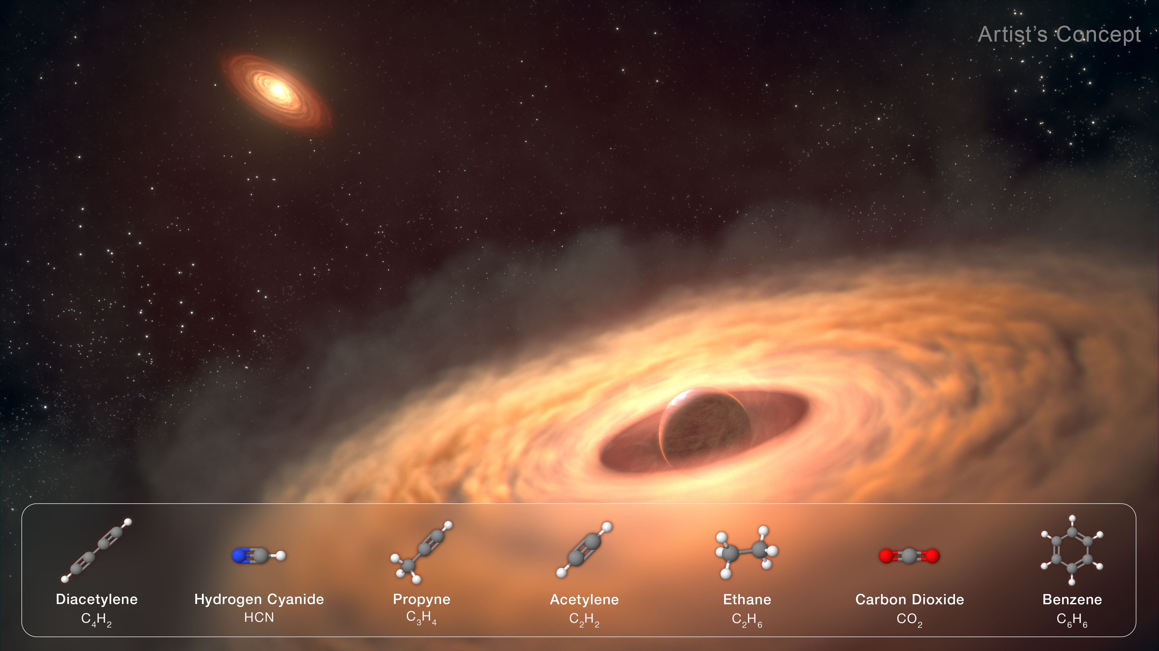
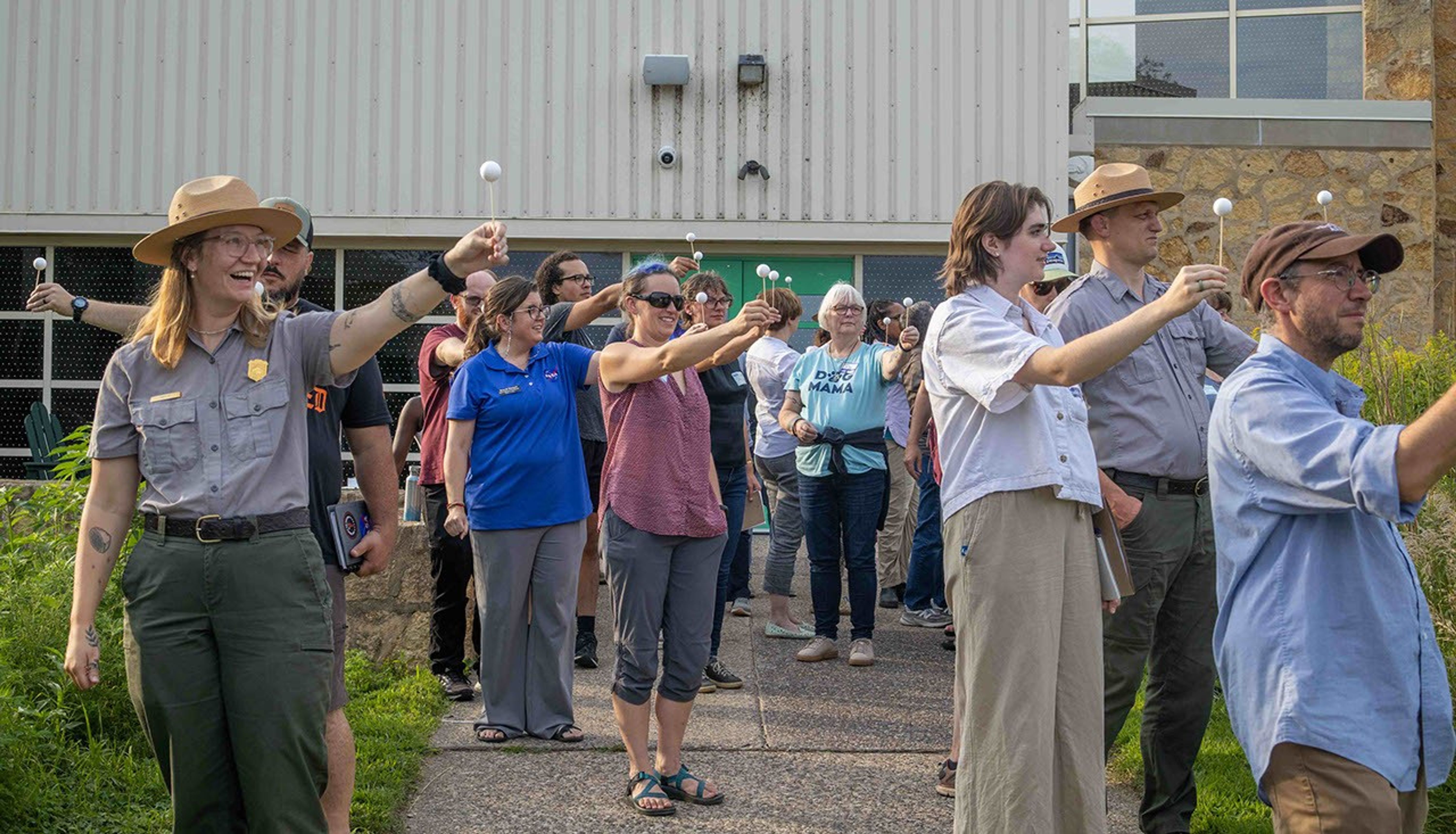
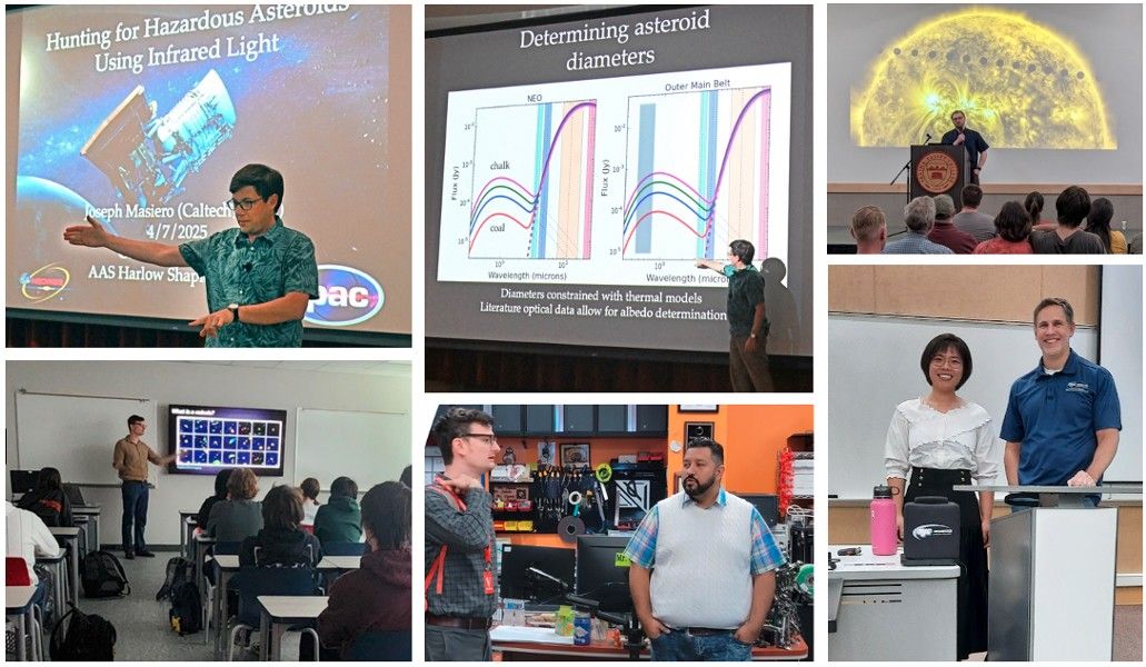
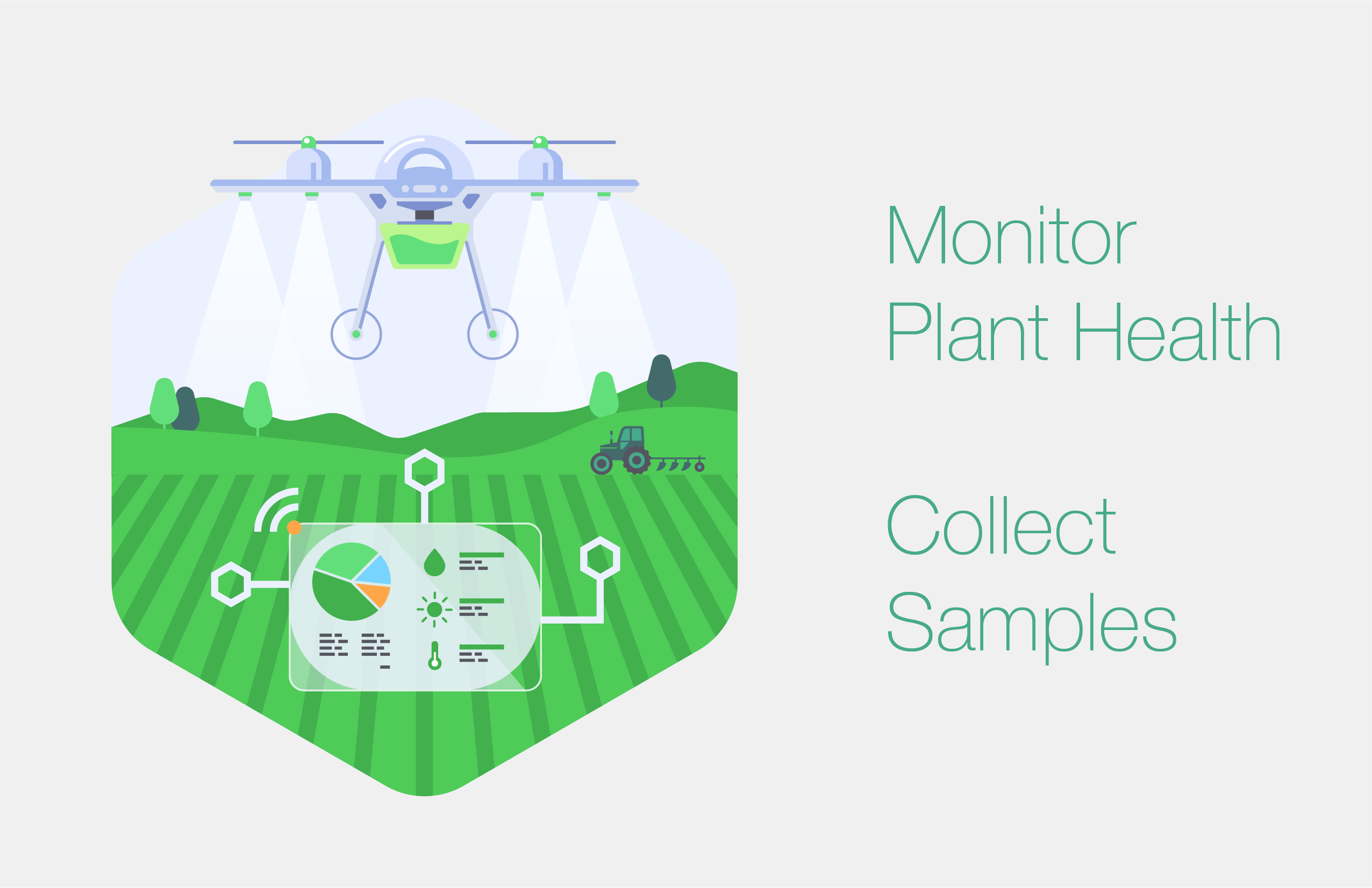
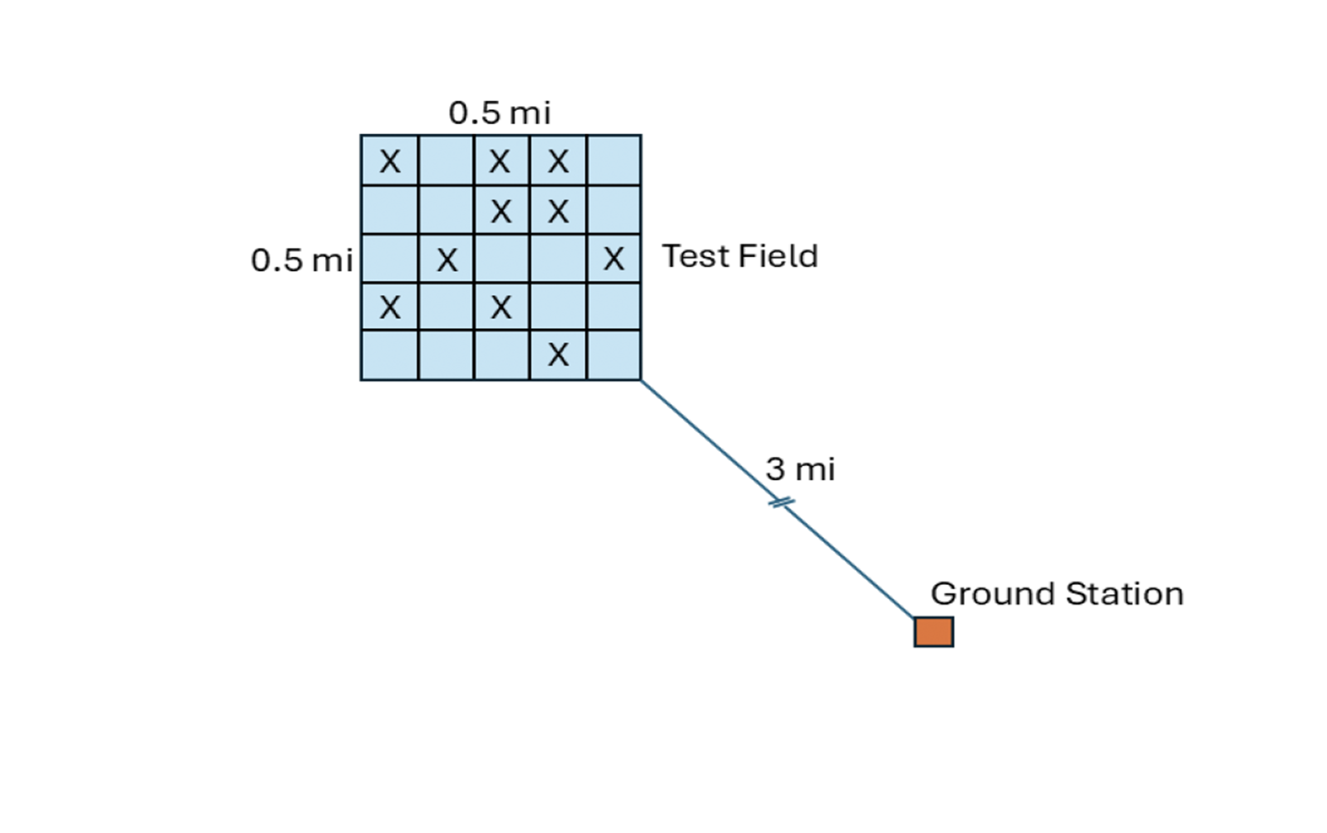
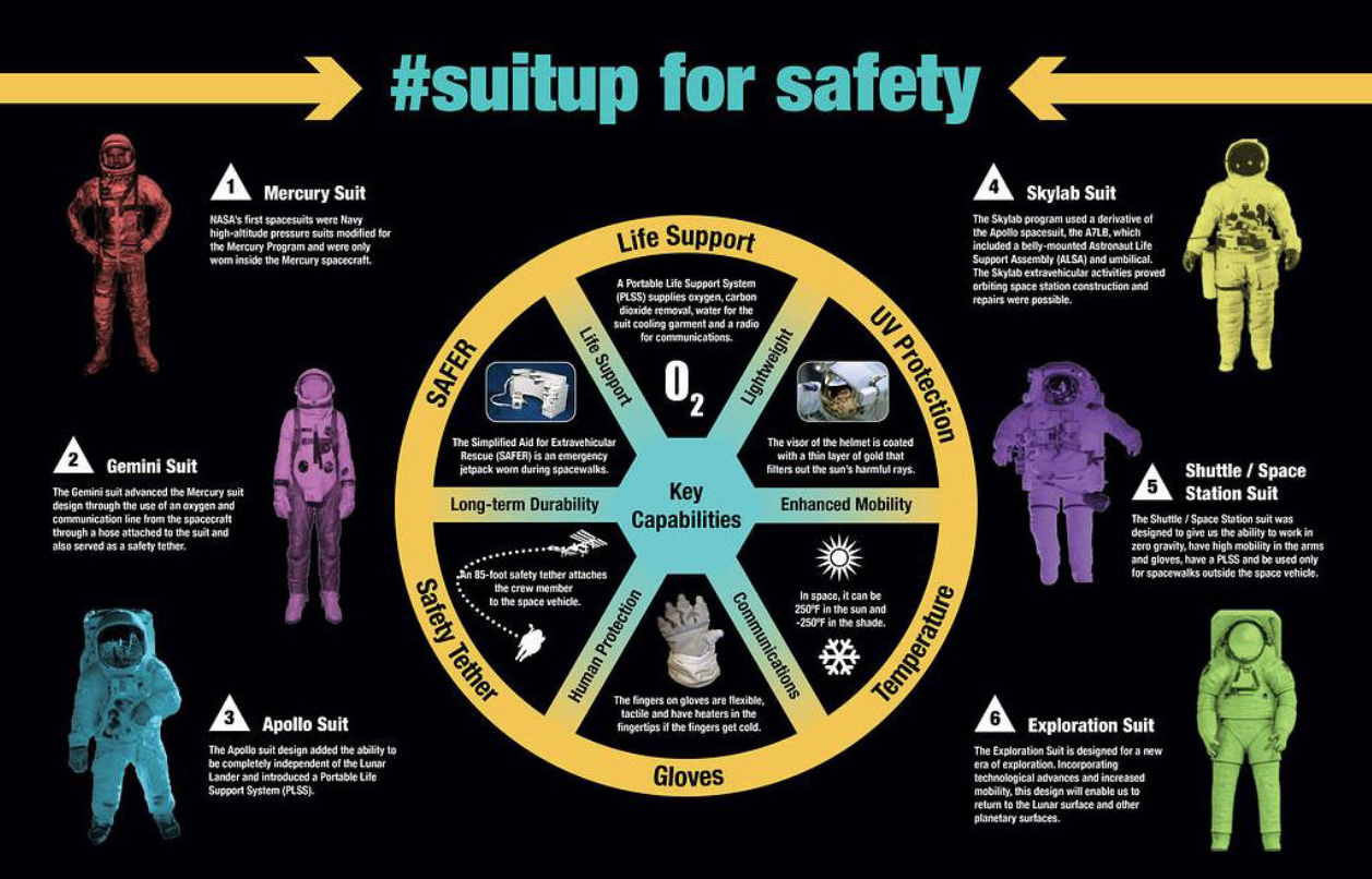
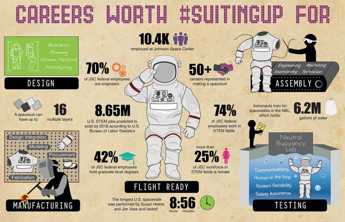
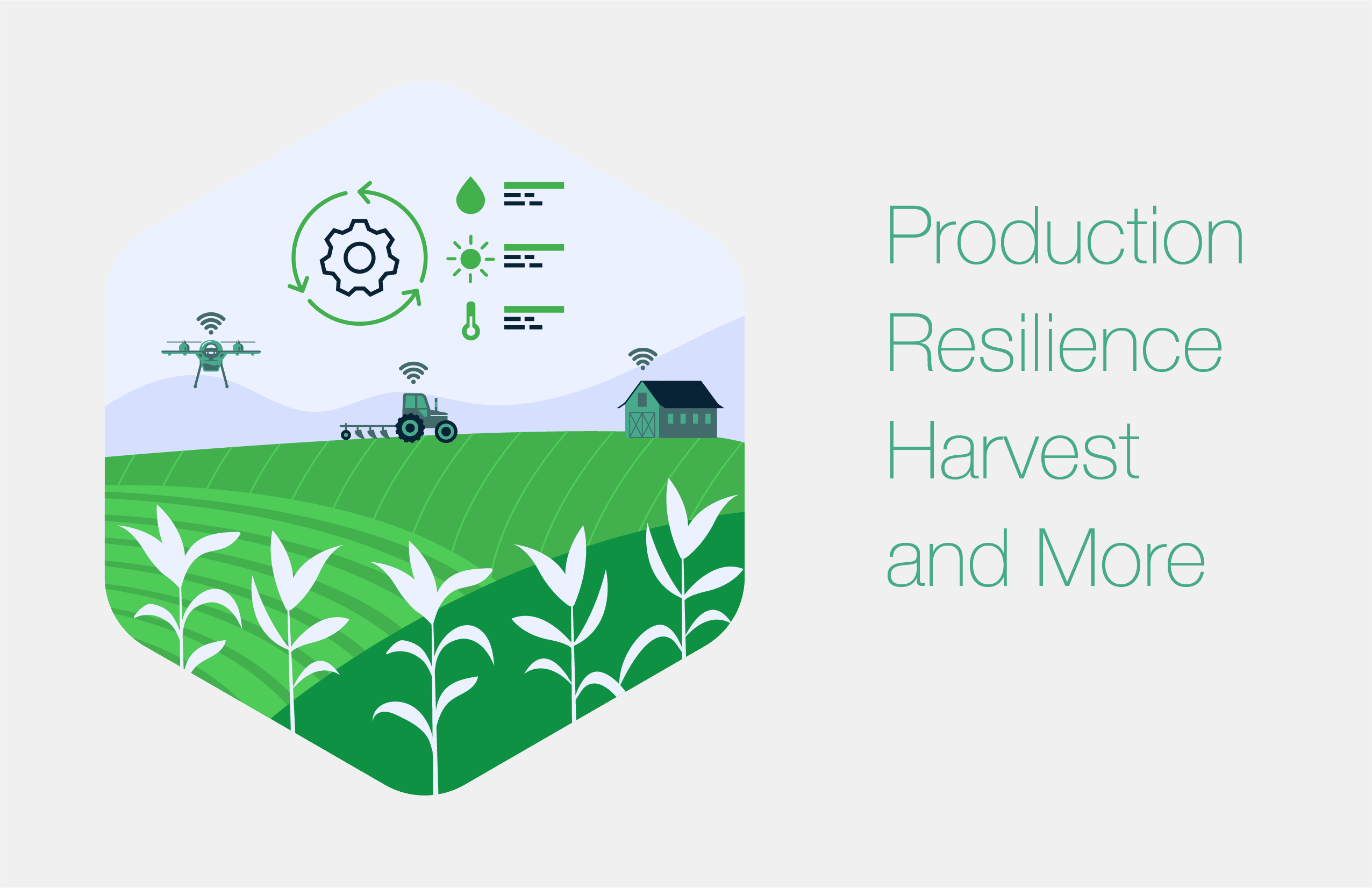
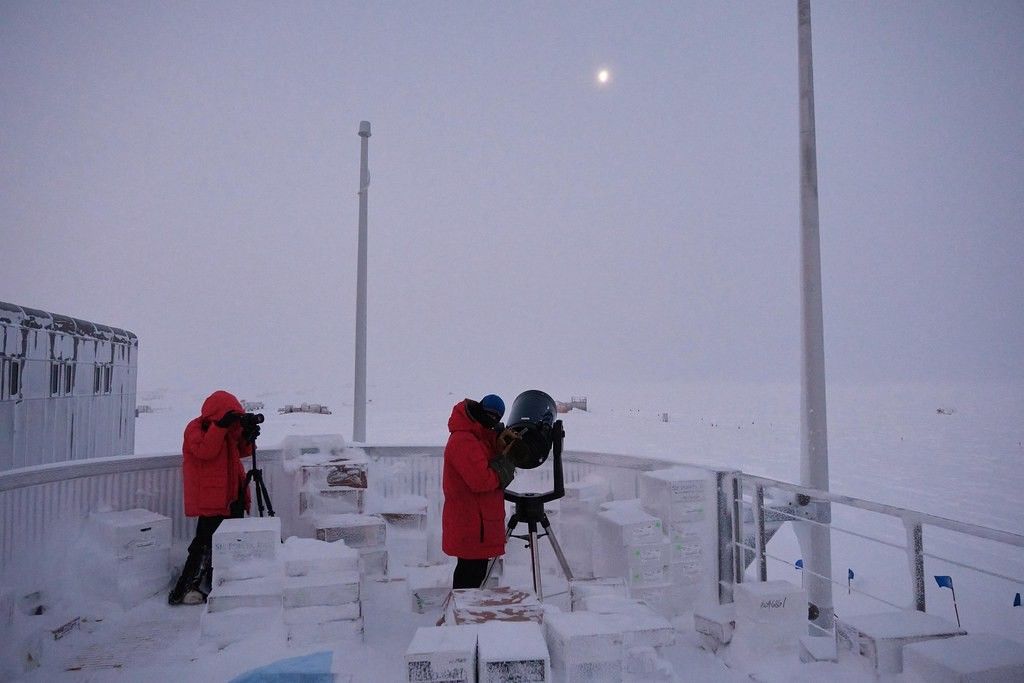