
NASA
Sols 4561-4562: Prepping to Drill at Altadena
- Curiosity Home
- Science
- News and Features
- Multimedia
- Mars Missions
- Mars Home
4 min read
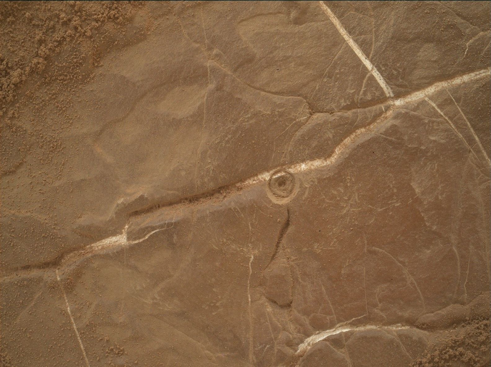
Sols 4561-4562: Prepping to Drill at Altadena NASA’s Mars rover Curiosity acquired this image of a recent DRT (Dust Removal Tool) site, showing off the marks created in the rocks by DRT — a motorized, wire-bristle brush on the turret at the end of the rover’s robotic arm — as well as a whitish vein that was revealed after the dust covering it was removed. Curiosity acquired this image using its Mars Hand Lens Imager (MAHLI), a camera mounted on the turret at the end of the robotic arm, which provides close-up views of the minerals, textures, and structures in Martian rocks and the surface layer of rocky debris and dust. Using an onboard process, MAHLI merges two to eight images to make a composite image of the same target acquired at different focus positions, to bring many features into focus in a single image. Curiosity merged this composite on June 4, 2025 — Sol 4560. Or Martian day 4,560 of the Mars Science Laboratory Mission — at 12:33:42 UTC. NASA/JPL-Caltech/MSSSWritten by Conor Hayes, Graduate Student at York University
Earth planning date: Wednesday, June 4, 2025
We are continuing to look for a suitable location to collect a drilled sample in this area. As you may recall from Monday’s plan, we performed a short “bump” of just under 4 meters (about 13 feet) hoping to find a drill target today after Monday’s analysis determined that there were no good targets in our previous workspace. Happily, today’s workspace was much more cooperative, and we were able to select the target “Altadena” as our next potential drill location. Altadena is a name that we’ve been saving for a special target, as its namesake here on Earth is a neighborhood next to JPL that was devastated by the Eaton Fire earlier this year. We’re about to enter our next mapping quadrangle, which will come with a new set of target names, so the team decided that using Altadena as the name for this drill site was an obvious choice.
The big activity in this plan is the next step in the drilling process. This activity is the “preload test,” which determines if the forces on the drill will be good while drilling, and the drill target won’t unexpectedly move or fracture. If we pass the preload test and find that the rock has the chemistry we’re looking for, we’ll be able to proceed with Altadena as our next drill site. If we don’t, we’ll have to decide whether to bump again or resume driving deeper into this potentially boxwork-bearing region.
Of course, the preload test isn’t the only thing we’re doing today. Coming in, it was looking like our time for other activities would be pretty tight due to power constraints imposed by preparations for drilling and keeping the rover warm during the cold Martian winter. However, we’ve recently implemented some new power-optimizing capabilities, which led to us having much more power today than we expected. This meant that we were able to add a whole additional hour of science time in addition to the hour that we already had scheduled.
Unsurprisingly, Altadena gets a lot of love in this plan to characterize it before we drill. This includes a ChemCam LIBS activity and a Mastcam observation, as well as some overnight observations by APXS and some MAHLI images. In addition, Mastcam will be observing some exposed stratigraphy at “Dana Point,” a light-toned vein at “Mission Trails” that will also be a ChemCam LIBS target, a few more nearby troughs, and a couple of sandy patches at “Camp Williams” to observe wind-driven sediment transport. Along with the two LIBS, ChemCam will be using its RMI camera to add to the pile of images we have of the Mishe Mokwa butte and the yardang unit off in the distance.
As the lead for the Atmosphere and Environment (ENV) group today, it looked like I was going to have a pretty light workload due to the power constraints preventing any ENV activities other than our usual REMS, RAD, and DAN observations. With the extra hour of science time, I was able to add a handful of new activities, including three Navcam cloud movies, a Navcam line-of-sight observation of dust within Gale Crater, and a Navcam survey to look for any dust devils that may be swirling around the rover. A pretty decent ENV science haul for a plan that started with nothing!
When we come into planning on Friday, we’ll hopefully have passed the preload test and will be able to turn Altadena into our 43rd drill hole in the coming sols, before we continue driving up the slopes of Mount Sharp.
Share Details Last Updated Jun 06, 2025 Related Terms Explore More 2 min read Searching for Ancient Rocks in the ‘Forlandet’ FlatsArticle
3 hours ago
3 min read Sols 4559-4560: Drill Campaign — Searching for a Boxwork Bedrock Drill Site
Article
2 days ago
2 min read Sols 4556-4558: It’s All in a Day’s (box)Work
Article
3 days ago
Keep Exploring Discover More Topics From NASA Mars
Mars is the fourth planet from the Sun, and the seventh largest. It’s the only planet we know of inhabited…
All Mars Resources
Explore this collection of Mars images, videos, resources, PDFs, and toolkits. Discover valuable content designed to inform, educate, and inspire,…
Rover Basics
Each robotic explorer sent to the Red Planet has its own unique capabilities driven by science. Many attributes of a…
Mars Exploration: Science Goals
The key to understanding the past, present or future potential for life on Mars can be found in NASA’s four…
Sols 4561-4562: Prepping to Drill at Altadena
- Curiosity Home
- Science
- News and Features
- Multimedia
- Mars Missions
- Mars Home
4 min read
Sols 4561-4562: Prepping to Drill at Altadena NASA’s Mars rover Curiosity acquired this image of a recent DRT (Dust Removal Tool) site, showing off the marks created in the rocks by DRT — a motorized, wire-bristle brush on the turret at the end of the rover’s robotic arm — as well as a whitish vein that was revealed after the dust covering it was removed. Curiosity acquired this image using its Mars Hand Lens Imager (MAHLI), a camera mounted on the turret at the end of the robotic arm, which provides close-up views of the minerals, textures, and structures in Martian rocks and the surface layer of rocky debris and dust. Using an onboard process, MAHLI merges two to eight images to make a composite image of the same target acquired at different focus positions, to bring many features into focus in a single image. Curiosity merged this composite on June 4, 2025 — Sol 4560. Or Martian day 4,560 of the Mars Science Laboratory Mission — at 12:33:42 UTC. NASA/JPL-Caltech/MSSSWritten by Conor Hayes, Graduate Student at York University
Earth planning date: Wednesday, June 4, 2025
We are continuing to look for a suitable location to collect a drilled sample in this area. As you may recall from Monday’s plan, we performed a short “bump” of just under 4 meters (about 13 feet) hoping to find a drill target today after Monday’s analysis determined that there were no good targets in our previous workspace. Happily, today’s workspace was much more cooperative, and we were able to select the target “Altadena” as our next potential drill location. Altadena is a name that we’ve been saving for a special target, as its namesake here on Earth is a neighborhood next to JPL that was devastated by the Eaton Fire earlier this year. We’re about to enter our next mapping quadrangle, which will come with a new set of target names, so the team decided that using Altadena as the name for this drill site was an obvious choice.
The big activity in this plan is the next step in the drilling process. This activity is the “preload test,” which determines if the forces on the drill will be good while drilling, and the drill target won’t unexpectedly move or fracture. If we pass the preload test and find that the rock has the chemistry we’re looking for, we’ll be able to proceed with Altadena as our next drill site. If we don’t, we’ll have to decide whether to bump again or resume driving deeper into this potentially boxwork-bearing region.
Of course, the preload test isn’t the only thing we’re doing today. Coming in, it was looking like our time for other activities would be pretty tight due to power constraints imposed by preparations for drilling and keeping the rover warm during the cold Martian winter. However, we’ve recently implemented some new power-optimizing capabilities, which led to us having much more power today than we expected. This meant that we were able to add a whole additional hour of science time in addition to the hour that we already had scheduled.
Unsurprisingly, Altadena gets a lot of love in this plan to characterize it before we drill. This includes a ChemCam LIBS activity and a Mastcam observation, as well as some overnight observations by APXS and some MAHLI images. In addition, Mastcam will be observing some exposed stratigraphy at “Dana Point,” a light-toned vein at “Mission Trails” that will also be a ChemCam LIBS target, a few more nearby troughs, and a couple of sandy patches at “Camp Williams” to observe wind-driven sediment transport. Along with the two LIBS, ChemCam will be using its RMI camera to add to the pile of images we have of the Mishe Mokwa butte and the yardang unit off in the distance.
As the lead for the Atmosphere and Environment (ENV) group today, it looked like I was going to have a pretty light workload due to the power constraints preventing any ENV activities other than our usual REMS, RAD, and DAN observations. With the extra hour of science time, I was able to add a handful of new activities, including three Navcam cloud movies, a Navcam line-of-sight observation of dust within Gale Crater, and a Navcam survey to look for any dust devils that may be swirling around the rover. A pretty decent ENV science haul for a plan that started with nothing!
When we come into planning on Friday, we’ll hopefully have passed the preload test and will be able to turn Altadena into our 43rd drill hole in the coming sols, before we continue driving up the slopes of Mount Sharp.
Share Details Last Updated Jun 06, 2025 Related Terms Explore More 2 min read Searching for Ancient Rocks in the ‘Forlandet’ FlatsArticle
3 hours ago
3 min read Sols 4559-4560: Drill Campaign — Searching for a Boxwork Bedrock Drill Site
Article
2 days ago
2 min read Sols 4556-4558: It’s All in a Day’s (box)Work
Article
3 days ago
Keep Exploring Discover More Topics From NASA Mars
Mars is the fourth planet from the Sun, and the seventh largest. It’s the only planet we know of inhabited…
All Mars Resources
Explore this collection of Mars images, videos, resources, PDFs, and toolkits. Discover valuable content designed to inform, educate, and inspire,…
Rover Basics
Each robotic explorer sent to the Red Planet has its own unique capabilities driven by science. Many attributes of a…
Mars Exploration: Science Goals
The key to understanding the past, present or future potential for life on Mars can be found in NASA’s four…
From Garment Industry to NASA: Meet Systems Engineer Daniel Eng
2 min read
Preparations for Next Moonwalk Simulations Underway (and Underwater) NASA Systems Engineer Daniel Eng serves his second year as a judge for the Aerospace Valley Robotics Competition at the Palmdale Aerospace Academy in Palmdale, California, in 2019. NASA/Lauren HughesAs a child in the 1960s, Daniel Eng spent his weekends in New York City’s garment district in Manhattan’s Lower East Side, clipping loose threads off finished clothing. He worked alongside his mother, a seamstress, and his father, a steam press operator, where he developed an eye for detail and a passion for learning. Now, he applies these capabilities at NASA, where he works as an engineer for the Air Mobility Pathfinders project.
“I often wonder whether the NASA worm magnet that someone left on my refrigerator in college, which I kept all these years, may have something to do with me ending up at NASA,” Eng said.
His route to NASA was not straightforward. Eng dropped out of high school to join the U.S. Army during the Vietnam War. He earned a GED certificate while on active duty and after his service earned a bachelor’s degree in electrical engineering from the University of Pennsylvania.
After college, Eng worked as a researcher investigating laser communications for the U.S. Navy, work which launched his career in aerospace. He then held jobs at several global corporations before landing at NASA.
NASA systems engineer, Daniel Eng, right, talks with student participants at the 2019 Aerospace Valley Robotics Competition at the Palmdale Aerospace Academy in Palmdale, California.NASA/Lauren Hughes“Looking back now, the Navy was ‘my launching point’ into the aerospace industry,” Eng said. “In more than four decades, I held various positions rising through the ranks ranging from circuit card design to systems analyst to production support to project and program management for advanced technology systems on a multitude of military and commercial aircraft projects.”
Today, he uses virtual models to plan and develop flight test requirements for piloted and automated aircraft, which will help guide future air taxi operations in cities.
“Engineers can virtually test computer models of designs, concepts, and operations before they are in place or even built, providing a safe and cost-effective way to verify the processes work the way they should,” Eng said.
He tells his grandkids to stay curious and ask a lot of questions so they can learn as much as possible.
“Be courteous, humble, kind, and respectful of people, and always remind yourself that you are just one human being among many ‘Earthlings,’” Eng said. “Teamwork is a very important aspect of success because rarely, if ever, does one person succeed on their own without help from others.”
Share Details Last Updated Jun 10, 2025 EditorDede DiniusContactLaura Mitchelllaura.a.mitchell@nasa.govLocationArmstrong Flight Research Center Related Terms Explore More 4 min read Paul Morris: Filming the Final Frontier Article 1 day ago 6 min read NASA Tests New Ways to Stick the Landing in Challenging Terrain Article 2 weeks ago 2 min read NASA Videographer Wins Top Award for Capturing Human Side of Science Article 3 weeks ago Keep Exploring Discover More Topics From NASAArmstrong Flight Research Center
Humans in Space
Climate Change
Solar System
Searching for Ancient Rocks in the ‘Forlandet’ Flats
- Perseverance Home
- Science
- News and Features
- Multimedia
- Mars Missions
- Mars Home
2 min read
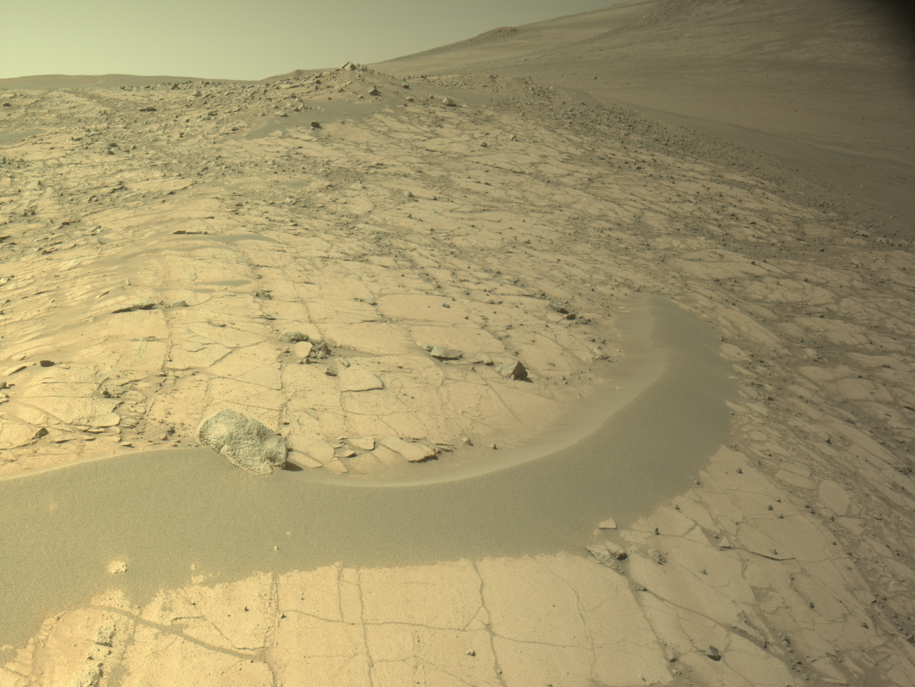
Searching for Ancient Rocks in the ‘Forlandet’ Flats NASA’s Mars Perseverance rover acquired this image of the “Fallbreen” workspace using its onboard Left Navigation Camera (Navcam). The camera is located high on the rover’s mast and aids in driving. This image was acquired on May 22, 2025 (Sol 1512, or Martian day 1,512 of the Mars 2020 mission) at the local mean solar time of 14:39:01. NASA/JPL-CaltechWritten by Henry Manelski, Ph.D. student at Purdue University
This week Perseverance continued its gradual descent into the relatively flat terrain outside of Jezero Crater. In this area, the science team expects to find rocks that could be among the oldest ever observed by the Perseverance rover — and perhaps any rover to have explored the surface of Mars — presenting a unique opportunity to understand Mars’ ancient past. Perseverance is now parked at “Fallbreen,” a light-toned bedrock exposure that the science team hopes to compare to the nearby olivine-bearing outcrop at “Copper Cove.” This could be a glimpse of the geologic unit rich in olivine and carbonate that stretches hundreds of kilometers to the west of Jezero Crater. Gaining insight into how these rocks formed could have profound implications for our constantly evolving knowledge of this region’s history. Perseverance’s recent traverses marked another notable transition. After rolling past Copper Cove, Perseverance entered the “Forlandet” quadrangle, a 1.2-square-kilometer (about 0.46 square mile, or 297-acre) area along the edge of the crater that the science team named after Forlandet National Park on the Norwegian archipelago of Svalbard. Discovered in the late 16th century by Dutch explorers, this icy set of islands captured the imagination of a generation of sailors searching for the Northwest Passage. While Perseverance is in the Forlandet quad, landforms and rock targets will be named informally after sites in and around this national park on Earth. As the rover navigates through its own narrow passes in the spirit of discovery, driving around sand dunes and breezing past buttes, we hope it channels the perseverance of the explorers who once gave these rocks their names.
Share Details Last Updated Jun 06, 2025 Related Terms Explore More 3 min read Sols 4559-4560: Drill Campaign — Searching for a Boxwork Bedrock Drill SiteArticle
2 days ago
2 min read Sols 4556-4558: It’s All in a Day’s (box)Work
Article
3 days ago
2 min read Sols 4554–4555: Let’s Try That One Again…
Article
1 week ago
Keep Exploring Discover More Topics From NASA Mars
Mars is the fourth planet from the Sun, and the seventh largest. It’s the only planet we know of inhabited…
All Mars Resources
Explore this collection of Mars images, videos, resources, PDFs, and toolkits. Discover valuable content designed to inform, educate, and inspire,…
Rover Basics
Each robotic explorer sent to the Red Planet has its own unique capabilities driven by science. Many attributes of a…
Mars Exploration: Science Goals
The key to understanding the past, present or future potential for life on Mars can be found in NASA’s four…
Searching for Ancient Rocks in the ‘Forlandet’ Flats
- Perseverance Home
- Science
- News and Features
- Multimedia
- Mars Missions
- Mars Home
2 min read
Searching for Ancient Rocks in the ‘Forlandet’ Flats NASA’s Mars Perseverance rover acquired this image of the “Fallbreen” workspace using its onboard Left Navigation Camera (Navcam). The camera is located high on the rover’s mast and aids in driving. This image was acquired on May 22, 2025 (Sol 1512, or Martian day 1,512 of the Mars 2020 mission) at the local mean solar time of 14:39:01. NASA/JPL-CaltechWritten by Henry Manelski, Ph.D. student at Purdue University
This week Perseverance continued its gradual descent into the relatively flat terrain outside of Jezero Crater. In this area, the science team expects to find rocks that could be among the oldest ever observed by the Perseverance rover — and perhaps any rover to have explored the surface of Mars — presenting a unique opportunity to understand Mars’ ancient past. Perseverance is now parked at “Fallbreen,” a light-toned bedrock exposure that the science team hopes to compare to the nearby olivine-bearing outcrop at “Copper Cove.” This could be a glimpse of the geologic unit rich in olivine and carbonate that stretches hundreds of kilometers to the west of Jezero Crater. Gaining insight into how these rocks formed could have profound implications for our constantly evolving knowledge of this region’s history. Perseverance’s recent traverses marked another notable transition. After rolling past Copper Cove, Perseverance entered the “Forlandet” quadrangle, a 1.2-square-kilometer (about 0.46 square mile, or 297-acre) area along the edge of the crater that the science team named after Forlandet National Park on the Norwegian archipelago of Svalbard. Discovered in the late 16th century by Dutch explorers, this icy set of islands captured the imagination of a generation of sailors searching for the Northwest Passage. While Perseverance is in the Forlandet quad, landforms and rock targets will be named informally after sites in and around this national park on Earth. As the rover navigates through its own narrow passes in the spirit of discovery, driving around sand dunes and breezing past buttes, we hope it channels the perseverance of the explorers who once gave these rocks their names.
Share Details Last Updated Jun 06, 2025 Related Terms Explore More 3 min read Sols 4559-4560: Drill Campaign — Searching for a Boxwork Bedrock Drill SiteArticle
2 days ago
2 min read Sols 4556-4558: It’s All in a Day’s (box)Work
Article
3 days ago
2 min read Sols 4554–4555: Let’s Try That One Again…
Article
1 week ago
Keep Exploring Discover More Topics From NASA Mars
Mars is the fourth planet from the Sun, and the seventh largest. It’s the only planet we know of inhabited…
All Mars Resources
Explore this collection of Mars images, videos, resources, PDFs, and toolkits. Discover valuable content designed to inform, educate, and inspire,…
Rover Basics
Each robotic explorer sent to the Red Planet has its own unique capabilities driven by science. Many attributes of a…
Mars Exploration: Science Goals
The key to understanding the past, present or future potential for life on Mars can be found in NASA’s four…
Dr. Natasha Schatzman Receives Vertical Flight Society (VFS) Award
In May 2025, Dr. Natasha Schatzman, aerospace engineer in the Aeromechanics Office at NASA Ames Research Center, received the inaugural Alex M. Stoll Award from the Vertical Flight Society (VFS). This award honors a professional in the field of vertical flight who “demonstrates an exceptional commitment to advancing not only the mission of their organization but makes extraordinary contributions to enhancing the well-being and happiness of their colleagues.” Dr. Schatzman began her career at Ames in 2008 as a student intern while simultaneously completing her undergraduate studies at the Georgia Institute of Technology (Georgia Tech). She stayed at Georgia Tech through graduate school and finished her Ph.D. dissertation in 2018 in the Aeronautical and Astronautical Engineering Department. Currently, Dr. Schatzman is focusing on assessments of rotorcraft performance and aeroacoustics through experimentation and modeling at Ames Research Center. The Alex M. Stoll Award is the second time she has been honored by the VFS. In 2023, Dr. Schatzman received the François-Xavier Bagnoud Vertical Flight Award which is given to a member “who is 35 years old or younger for their career-to-date outstanding contributions to vertical flight technology.” More information on Dr. Schatzman’s 2025 award is at: https://vtol.org/awards-and-contests/vertical-flight-society-award-winners?awardID=28
About the AuthorOsvaldo R. Sosa ValleOsvaldo Sosa is a dedicated and detail-oriented project coordinator at NASA Ames Research Center, where he supports operations for the Aeronautics Directorate. He is part of the Strategic Communications Team and serves as managing editor for the Aeronautics topic on the NASA website. With experience in event coordination, logistics, and stakeholder engagement, Osvaldo brings strong organizational and communication skills to every project. He is passionate about driving innovation, fostering strong leadership, and streamlining operations to enhance team collaboration and organizational impact.
Explore More 2 min read NASA Provides Hardware for Space Station DNA Repair Experiment Article 3 days ago 3 min read NASA’s Moffett Federal Airfield Hosts Boeing Digital Taxi Tests Article 3 weeks ago 3 min read Winners Announced in NASA’s 2025 Gateways to Blue Skies Competition Article 3 weeks ago Keep Exploring Discover More Topics From NASAMissions
Humans in Space
Climate Change
Solar System
Share Details Last Updated Jun 06, 2025 Related TermsDr. Natasha Schatzman Receives Vertical Flight Society (VFS) Award
In May 2025, Dr. Natasha Schatzman, aerospace engineer in the Aeromechanics Office at NASA Ames Research Center, received the inaugural Alex M. Stoll Award from the Vertical Flight Society (VFS). This award honors a professional in the field of vertical flight who “demonstrates an exceptional commitment to advancing not only the mission of their organization but makes extraordinary contributions to enhancing the well-being and happiness of their colleagues.” Dr. Schatzman began her career at Ames in 2008 as a student intern while simultaneously completing her undergraduate studies at the Georgia Institute of Technology (Georgia Tech). She stayed at Georgia Tech through graduate school and finished her Ph.D. dissertation in 2018 in the Aeronautical and Astronautical Engineering Department. Currently, Dr. Schatzman is focusing on assessments of rotorcraft performance and aeroacoustics through experimentation and modeling at Ames Research Center. The Alex M. Stoll Award is the second time she has been honored by the VFS. In 2023, Dr. Schatzman received the François-Xavier Bagnoud Vertical Flight Award which is given to a member “who is 35 years old or younger for their career-to-date outstanding contributions to vertical flight technology.” More information on Dr. Schatzman’s 2025 award is at: https://vtol.org/awards-and-contests/vertical-flight-society-award-winners?awardID=28
About the AuthorOsvaldo R. Sosa ValleOsvaldo Sosa is a dedicated and detail-oriented project coordinator at NASA Ames Research Center, where he supports operations for the Aeronautics Directorate. He is part of the Strategic Communications Team and serves as managing editor for the Aeronautics topic on the NASA website. With experience in event coordination, logistics, and stakeholder engagement, Osvaldo brings strong organizational and communication skills to every project. He is passionate about driving innovation, fostering strong leadership, and streamlining operations to enhance team collaboration and organizational impact.
Explore More 2 min read NASA Provides Hardware for Space Station DNA Repair Experiment Article 2 days ago 3 min read NASA’s Moffett Federal Airfield Hosts Boeing Digital Taxi Tests Article 2 weeks ago 3 min read Winners Announced in NASA’s 2025 Gateways to Blue Skies Competition Article 2 weeks ago Keep Exploring Discover More Topics From NASAMissions
Humans in Space
Climate Change
Solar System
Share Details Last Updated Jun 06, 2025 Related TermsWebb Sees Sombrero Galaxy in Near-Infrared
Webb Sees Sombrero Galaxy in Near-Infrared
After capturing an image of the iconic Sombrero galaxy at mid-infrared wavelengths in late 2024, NASA’s James Webb Space Telescope has now followed up with an observation in the near-infrared. In the newest image, released on June 3, 2025, the Sombrero galaxy’s tightly packed group of stars at the galaxy’s center is illuminated while the dust in the outer edges of the disk blocks some stellar light. Studying galaxies like the Sombrero at different wavelengths, including the near-infrared and mid-infrared with Webb, as well as the visible with NASA’s Hubble Space Telescope, helps astronomers understand how this complex system of stars, dust, and gas formed and evolved, along with the interplay of that material.
Learn more about the Sombrero galaxy and what this new view can tell us.
Image credit: NASA, ESA, CSA, STScI
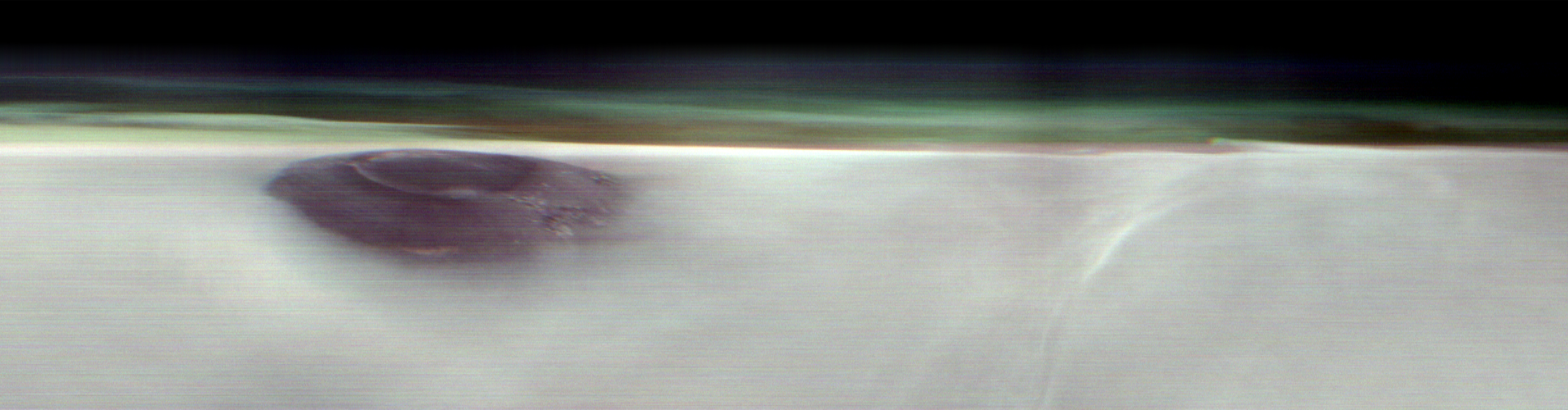
NASA Mars Orbiter Captures Volcano Peeking Above Morning Cloud Tops
The 2001 Odyssey spacecraft captured a first-of-its-kind look at Arsia Mons, which dwarfs Earth’s tallest volcanoes.
A new panorama from NASA’s 2001 Mars Odyssey orbiter shows one of the Red Planet’s biggest volcanoes, Arsia Mons, poking through a canopy of clouds just before dawn. Arsia Mons and two other volcanoes form what is known as the Tharsis Montes, or Tharsis Mountains, which are often surrounded by water ice clouds (as opposed to Mars’ equally common carbon dioxide clouds), especially in the early morning. This panorama marks the first time one of the volcanoes has been imaged on the planet’s horizon, offering the same perspective of Mars that astronauts have of the Earth when they peer down from the International Space Station.
Launched in 2001, Odyssey is the longest-running mission orbiting another planet, and this new panorama represents the kind of science the orbiter began pursuing in 2023, when it captured the first of its now four high-altitude images of the Martian horizon. To get them, the spacecraft rotates 90 degrees while in orbit so that its camera, built to study the Martian surface, can snap the image.
Arsia Mons is the southernmost of the three volcanoes that make up Tharsis Montes, shown in the center of this cropped topographic map of Mars. Olympus Mons, the solar system’s largest volcano, is at upper left. The western end of Valles Marineris begins cutting its wide swath across the planet at lower right.NASA/JPL-CaltechThe angle allows scientists to see dust and water ice cloud layers, while the series of images enables them to observe changes over the course of seasons.
“We’re seeing some really significant seasonal differences in these horizon images,” said planetary scientist Michael D. Smith of NASA’s Goddard Space Flight Center in Greenbelt, Maryland. “It’s giving us new clues to how Mars’ atmosphere evolves over time.”
Understanding Mars’ clouds is particularly important for understanding the planet’s weather and how phenomena like dust storms occur. That information, in turn, can benefit future missions, including entry, descent and landing operations.
Volcanic GiantsWhile these images focus on the upper atmosphere, the Odyssey team has tried to include interesting surface features in them, as well. In Odyssey’s latest horizon image, captured on May 2, Arsia Mons stands 12 miles (20 kilometers) high, roughly twice as tall as Earth’s largest volcano, Mauna Loa, which rises 6 miles (9 kilometers) above the seafloor.
The southernmost of the Tharsis volcanoes, Arsia Mons is the cloudiest of the three. The clouds form when air expands as it blows up the sides of the mountain and then rapidly cools. They are especially thick when Mars is farthest from the Sun, a period called aphelion. The band of clouds that forms across the planet’s equator at this time of year is called the aphelion cloud belt, and it’s on proud display in Odyssey’s new panorama.
“We picked Arsia Mons hoping we would see the summit poke above the early morning clouds. And it didn’t disappoint,” said Jonathon Hill of Arizona State University in Tempe, operations lead for Odyssey’s camera, called the Thermal Emission Imaging System, or THEMIS.
The THEMIS camera can view Mars in both visible and infrared light. The latter allows scientists to identify areas of the subsurface that contain water ice, which could be used by the first astronauts to land on Mars. The camera can also image Mars’ tiny moons, Phobos and Deimos, allowing scientists to analyze their surface composition.
More About OdysseyNASA’s Jet Propulsion Laboratory, a division of Caltech in Pasadena, California, manages the Mars Odyssey Project for the agency’s Science Mission Directorate in Washington as part of NASA’s Mars Exploration Program portfolio. Lockheed Martin Space in Denver built the spacecraft and collaborates with JPL on mission operations. THEMIS was built and is operated by Arizona State University in Tempe.
For more about Odyssey:
https://science.nasa.gov/mission/odyssey/
News Media ContactsAndrew Good
Jet Propulsion Laboratory, Pasadena, Calif.
818-393-2433
andrew.c.good@jpl.nasa.gov
Karen Fox / Molly Wasser
NASA Headquarters, Washington
202-358-1600
karen.c.fox@nasa.gov / molly.l.wasser@nasa.gov
2025-077
Share Details Last Updated Jun 06, 2025 Related Terms Explore More 6 min read NASA’s Ready-to-Use Dataset Details Land Motion Across North America Article 3 days ago 5 min read 3 Black Holes Caught Eating Massive Stars in NASA DataBlack holes are invisible to us unless they interact with something else. Some continuously eat…
Article 5 days ago 4 min read NASA’s MAVEN Makes First Observation of Atmospheric Sputtering at MarsAfter a decade of searching, NASA’s MAVEN (Mars Atmosphere Volatile Evolution) mission has, for the…
Article 2 weeks ago Keep Exploring Discover More Topics From NASAMissions
Humans in Space
Climate Change
Solar System
NASA Mars Orbiter Captures Volcano Peeking Above Morning Cloud Tops
The 2001 Odyssey spacecraft captured a first-of-its-kind look at Arsia Mons, which dwarfs Earth’s tallest volcanoes.
A new panorama from NASA’s 2001 Mars Odyssey orbiter shows one of the Red Planet’s biggest volcanoes, Arsia Mons, poking through a canopy of clouds just before dawn. Arsia Mons and two other volcanoes form what is known as the Tharsis Montes, or Tharsis Mountains, which are often surrounded by water ice clouds (as opposed to Mars’ equally common carbon dioxide clouds), especially in the early morning. This panorama marks the first time one of the volcanoes has been imaged on the planet’s horizon, offering the same perspective of Mars that astronauts have of the Earth when they peer down from the International Space Station.
Launched in 2001, Odyssey is the longest-running mission orbiting another planet, and this new panorama represents the kind of science the orbiter began pursuing in 2023, when it captured the first of its now four high-altitude images of the Martian horizon. To get them, the spacecraft rotates 90 degrees while in orbit so that its camera, built to study the Martian surface, can snap the image.
Arsia Mons is the southernmost of the three volcanoes that make up Tharsis Montes, shown in the center of this cropped topographic map of Mars. Olympus Mons, the solar system’s largest volcano, is at upper left. The western end of Valles Marineris begins cutting its wide swath across the planet at lower right.NASA/JPL-CaltechThe angle allows scientists to see dust and water ice cloud layers, while the series of images enables them to observe changes over the course of seasons.
“We’re seeing some really significant seasonal differences in these horizon images,” said planetary scientist Michael D. Smith of NASA’s Goddard Space Flight Center in Greenbelt, Maryland. “It’s giving us new clues to how Mars’ atmosphere evolves over time.”
Understanding Mars’ clouds is particularly important for understanding the planet’s weather and how phenomena like dust storms occur. That information, in turn, can benefit future missions, including entry, descent and landing operations.
Volcanic GiantsWhile these images focus on the upper atmosphere, the Odyssey team has tried to include interesting surface features in them, as well. In Odyssey’s latest horizon image, captured on May 2, Arsia Mons stands 12 miles (20 kilometers) high, roughly twice as tall as Earth’s largest volcano, Mauna Loa, which rises 6 miles (9 kilometers) above the seafloor.
The southernmost of the Tharsis volcanoes, Arsia Mons is the cloudiest of the three. The clouds form when air expands as it blows up the sides of the mountain and then rapidly cools. They are especially thick when Mars is farthest from the Sun, a period called aphelion. The band of clouds that forms across the planet’s equator at this time of year is called the aphelion cloud belt, and it’s on proud display in Odyssey’s new panorama.
“We picked Arsia Mons hoping we would see the summit poke above the early morning clouds. And it didn’t disappoint,” said Jonathon Hill of Arizona State University in Tempe, operations lead for Odyssey’s camera, called the Thermal Emission Imaging System, or THEMIS.
The THEMIS camera can view Mars in both visible and infrared light. The latter allows scientists to identify areas of the subsurface that contain water ice, which could be used by the first astronauts to land on Mars. The camera can also image Mars’ tiny moons, Phobos and Deimos, allowing scientists to analyze their surface composition.
More About OdysseyNASA’s Jet Propulsion Laboratory, a division of Caltech in Pasadena, California, manages the Mars Odyssey Project for the agency’s Science Mission Directorate in Washington as part of NASA’s Mars Exploration Program portfolio. Lockheed Martin Space in Denver built the spacecraft and collaborates with JPL on mission operations. THEMIS was built and is operated by Arizona State University in Tempe.
For more about Odyssey:
https://science.nasa.gov/mission/odyssey/
News Media ContactsAndrew Good
Jet Propulsion Laboratory, Pasadena, Calif.
818-393-2433
andrew.c.good@jpl.nasa.gov
Karen Fox / Molly Wasser
NASA Headquarters, Washington
202-358-1600
karen.c.fox@nasa.gov / molly.l.wasser@nasa.gov
2025-077
Share Details Last Updated Jun 06, 2025 Related Terms Explore More 6 min read NASA’s Ready-to-Use Dataset Details Land Motion Across North America Article 2 days ago 5 min read 3 Black Holes Caught Eating Massive Stars in NASA DataBlack holes are invisible to us unless they interact with something else. Some continuously eat…
Article 4 days ago 4 min read NASA’s MAVEN Makes First Observation of Atmospheric Sputtering at MarsAfter a decade of searching, NASA’s MAVEN (Mars Atmosphere Volatile Evolution) mission has, for the…
Article 1 week ago Keep Exploring Discover More Topics From NASAMissions
Humans in Space
Climate Change
Solar System
NASA’s Ready-to-Use Dataset Details Land Motion Across North America
An online tool maps measurements and enables non-experts to understand earthquakes, subsidence, landslides, and other types of land motion.
NASA is collaborating with the Alaska Satellite Facility in Fairbanks to create a powerful web-based tool that will show the movement of land across North America down to less than an inch. The online portal and its underlying dataset unlock a trove of satellite radar measurements that can help anyone identify where and by how much the land beneath their feet may be moving — whether from earthquakes, volcanoes, landslides, or the extraction of underground natural resources such as groundwater.
Spearheaded by NASA’s Observational Products for End-Users from Remote Sensing Analysis (OPERA) project at the agency’s Jet Propulsion Laboratory in Southern California, the effort equips users with information that would otherwise take years of training to produce. The project builds on measurements from spaceborne synthetic aperture radars, or SARs, to generate high-resolution data on how Earth’s surface is moving.
Formally called the North America Surface Displacement Product Suite, the new dataset comes ready to use with measurements dating to 2016, and the portal allows users to view those measurements at a local, state, and regional scales in a few seconds. For someone not using the dataset or website, it could take days or longer to do a similar analysis.
“You can zoom in to your country, your state, your city block, and look at how the land there is moving over time,” said David Bekaert, the OPERA project manager and a JPL radar scientist. “You can see that by a simple mouse click.”
The portal currently includes measurements for millions of pixels across the U.S. Southwest, northern Mexico, and the New York metropolitan region, each representing a 200-foot-by-200-foot (60-meter-by-60-meter) area on the ground. By the end of 2025, OPERA will add data to cover the rest of the United States, Central America, and Canada within 120 miles (200 kilometers) of the U.S. border. When a user clicks on a pixel, the system pulls measurements from hundreds of files to create a graph visualizing the land surface’s cumulative movement over time.
The OPERA portal shows how land is sinking in Freshkills Park, which is being built on the site of a former landfill on Staten Island, New York. Landfills tend to sink over time as waste decomposes and settles. The blue dot marks the spot where the portal is showing movement in the graph.Alaska Satellite Facility Land is rising at the Colorado River’s outlet to the Gulf of California, as indicated in this screenshot from the OPERA portal. The uplift is due to the sediment from the river building up over time. The graph shows that the land at the blue dot has risen about 8 inches (20 centimeters) since 2016.Alaska Satellite Facility The OPERA portal shows that land near Willcox, Arizona, subsided about 8 inches (20 centimeters) since between 2016 and 2021, in large part due to groundwater pumping. The region is part of an area being managed by state water officials.Alaska Satellite Facility“The OPERA project automated the end-to-end SAR data processing system such that users and decision-makers can focus on discovering where the land surface may be moving in their areas of interest,” said Gerald Bawden, program scientist responsible for OPERA at NASA Headquarters in Washington. “This will provide a significant advancement in identifying and understanding potential threats to the end users, while providing cost and time savings for agencies.”
For example, water-management bureaus and state geological surveys will be able to directly use the OPERA products without needing to make big investments in data storage, software engineering expertise, and computing muscle.
How It WorksTo create the displacement product, the OPERA team continuously draws data from the ESA (European Space Agency) Sentinel-1 radar satellites, the first of which launched in 2014. Data from NISAR, the NASA-ISRO (Indian Space Research Organisation) Synthetic Aperture Radar mission, will be added to the mix after that spacecraft launches later this year.
Satellite-borne radars work by emitting microwave pulses at Earth’s surface. The signals scatter when they hit land and water surfaces, buildings, and other objects. Raw data consists of the strength and time delay of the signals that echo back to the sensor.
To understand how land in a given area is moving, OPERA algorithms automate steps in an otherwise painstaking process. Without OPERA, a researcher would first download hundreds or thousands of data files, each representing a pass of the radar over the point of interest, then make sure the data aligned geographically over time and had precise coordinates.
Then they would use a computationally intensive technique called radar interferometry to gauge how much the land moved, if at all, and in which direction — towards the satellite, which would indicate the land rose, or away from the satellite, which would mean it sank.
“The OPERA project has helped bring that capability to the masses, making it more accessible to state and federal agencies, and also users wondering, ‘What’s going on around my house?’” said Franz Meyer, chief scientist of the Alaska Satellite Facility, a part of the University of Alaska Fairbanks Geophysical Institute.
Monitoring GroundwaterSinking land is a top priority to the Arizona Department of Water Resources. From the 1950s through the 1980s, it was the main form of ground movement officials saw, as groundwater pumping increased alongside growth in the state’s population and agricultural industry. In 1980, the state enacted the Groundwater Management Act, which reduced its reliance on groundwater in highly populated areas and included requirements to monitor its use.
The department began to measure this sinking, called subsidence, with radar data from various satellites in the early 2000s, using a combination of SAR, GPS-based monitoring, and traditional surveying to inform groundwater-management decisions.
Now, the OPERA dataset and portal will help the agency share subsidence information with officials and community members, said Brian Conway, the department’s principal hydrogeologist and supervisor of its geophysics unit. They won’t replace the SAR analysis he performs, but they will offer points of comparison for his calculations. Because the dataset and portal will cover the entire state, they also could identify areas not yet known to be subsiding.
“It’s a great tool to say, ‘Let’s look at those areas more intensely with our own SAR processing,’” Conway said.
The displacement product is part of a series of data products OPERA has released since 2023. The project began in 2020 with a multidisciplinary team of scientists at JPL working to address satellite data needs across different federal agencies. Through the Satellite Needs Working Group, those agencies submitted their requests, and the OPERA team worked to improve access to information to aid a range of efforts such as disaster response, deforestation tracking, and wildfire monitoring.
NASA-Led Project Tracking Changes to Water, Ecosystems, Land Surface News Media ContactsAndrew Wang / Jane J. Lee
Jet Propulsion Laboratory, Pasadena, Calif.
626-379-6874 / 818-354-0307
andrew.wang@jpl.nasa.gov / jane.j.lee@jpl.nasa.gov
2025-076
Share Details Last Updated Jun 06, 2025 Related Terms Explore More 9 min read NASA’s TROPICS Mission: Offering Detailed Images and Analysis of Tropical CyclonesIntroduction Tropical cyclones represent a danger to life, property, and the economies of communities. Researchers…
Article 4 hours ago 4 min read NASA Mars Orbiter Captures Volcano Peeking Above Morning Cloud Tops Article 3 days ago 8 min read ICESat-2 Applications Team Hosts Satellite Bathymetry WorkshopIntroduction On September 15, 2018, the NASA Ice, Cloud, and land Elevation Satellite-2 (ICESat-2) mission…
Article 4 days ago Keep Exploring Discover More Topics From NASAMissions
Humans in Space
Climate Change
Solar System
NASA’s Ready-to-Use Dataset Details Land Motion Across North America
An online tool maps measurements and enables non-experts to understand earthquakes, subsidence, landslides, and other types of land motion.
NASA is collaborating with the Alaska Satellite Facility in Fairbanks to create a powerful web-based tool that will show the movement of land across North America down to less than an inch. The online portal and its underlying dataset unlock a trove of satellite radar measurements that can help anyone identify where and by how much the land beneath their feet may be moving — whether from earthquakes, volcanoes, landslides, or the extraction of underground natural resources such as groundwater.
Spearheaded by NASA’s Observational Products for End-Users from Remote Sensing Analysis (OPERA) project at the agency’s Jet Propulsion Laboratory in Southern California, the effort equips users with information that would otherwise take years of training to produce. The project builds on measurements from spaceborne synthetic aperture radars, or SARs, to generate high-resolution data on how Earth’s surface is moving.
Formally called the North America Surface Displacement Product Suite, the new dataset comes ready to use with measurements dating to 2016, and the portal allows users to view those measurements at a local, state, and regional scales in a few seconds. For someone not using the dataset or website, it could take days or longer to do a similar analysis.
“You can zoom in to your country, your state, your city block, and look at how the land there is moving over time,” said David Bekaert, the OPERA project manager and a JPL radar scientist. “You can see that by a simple mouse click.”
The portal currently includes measurements for millions of pixels across the U.S. Southwest, northern Mexico, and the New York metropolitan region, each representing a 200-foot-by-200-foot (60-meter-by-60-meter) area on the ground. By the end of 2025, OPERA will add data to cover the rest of the United States, Central America, and Canada within 120 miles (200 kilometers) of the U.S. border. When a user clicks on a pixel, the system pulls measurements from hundreds of files to create a graph visualizing the land surface’s cumulative movement over time.
The OPERA portal shows how land is sinking in Freshkills Park, which is being built on the site of a former landfill on Staten Island, New York. Landfills tend to sink over time as waste decomposes and settles. The blue dot marks the spot where the portal is showing movement in the graph.Alaska Satellite Facility Land is rising at the Colorado River’s outlet to the Gulf of California, as indicated in this screenshot from the OPERA portal. The uplift is due to the sediment from the river building up over time. The graph shows that the land at the blue dot has risen about 8 inches (20 centimeters) since 2016.Alaska Satellite Facility The OPERA portal shows that land near Willcox, Arizona, subsided about 8 inches (20 centimeters) since between 2016 and 2021, in large part due to groundwater pumping. The region is part of an area being managed by state water officials.Alaska Satellite Facility“The OPERA project automated the end-to-end SAR data processing system such that users and decision-makers can focus on discovering where the land surface may be moving in their areas of interest,” said Gerald Bawden, program scientist responsible for OPERA at NASA Headquarters in Washington. “This will provide a significant advancement in identifying and understanding potential threats to the end users, while providing cost and time savings for agencies.”
For example, water-management bureaus and state geological surveys will be able to directly use the OPERA products without needing to make big investments in data storage, software engineering expertise, and computing muscle.
How It WorksTo create the displacement product, the OPERA team continuously draws data from the ESA (European Space Agency) Sentinel-1 radar satellites, the first of which launched in 2014. Data from NISAR, the NASA-ISRO (Indian Space Research Organisation) Synthetic Aperture Radar mission, will be added to the mix after that spacecraft launches later this year.
Satellite-borne radars work by emitting microwave pulses at Earth’s surface. The signals scatter when they hit land and water surfaces, buildings, and other objects. Raw data consists of the strength and time delay of the signals that echo back to the sensor.
To understand how land in a given area is moving, OPERA algorithms automate steps in an otherwise painstaking process. Without OPERA, a researcher would first download hundreds or thousands of data files, each representing a pass of the radar over the point of interest, then make sure the data aligned geographically over time and had precise coordinates.
Then they would use a computationally intensive technique called radar interferometry to gauge how much the land moved, if at all, and in which direction — towards the satellite, which would indicate the land rose, or away from the satellite, which would mean it sank.
“The OPERA project has helped bring that capability to the masses, making it more accessible to state and federal agencies, and also users wondering, ‘What’s going on around my house?’” said Franz Meyer, chief scientist of the Alaska Satellite Facility, a part of the University of Alaska Fairbanks Geophysical Institute.
Monitoring GroundwaterSinking land is a top priority to the Arizona Department of Water Resources. From the 1950s through the 1980s, it was the main form of ground movement officials saw, as groundwater pumping increased alongside growth in the state’s population and agricultural industry. In 1980, the state enacted the Groundwater Management Act, which reduced its reliance on groundwater in highly populated areas and included requirements to monitor its use.
The department began to measure this sinking, called subsidence, with radar data from various satellites in the early 2000s, using a combination of SAR, GPS-based monitoring, and traditional surveying to inform groundwater-management decisions.
Now, the OPERA dataset and portal will help the agency share subsidence information with officials and community members, said Brian Conway, the department’s principal hydrogeologist and supervisor of its geophysics unit. They won’t replace the SAR analysis he performs, but they will offer points of comparison for his calculations. Because the dataset and portal will cover the entire state, they also could identify areas not yet known to be subsiding.
“It’s a great tool to say, ‘Let’s look at those areas more intensely with our own SAR processing,’” Conway said.
The displacement product is part of a series of data products OPERA has released since 2023. The project began in 2020 with a multidisciplinary team of scientists at JPL working to address satellite data needs across different federal agencies. Through the Satellite Needs Working Group, those agencies submitted their requests, and the OPERA team worked to improve access to information to aid a range of efforts such as disaster response, deforestation tracking, and wildfire monitoring.
NASA-Led Project Tracking Changes to Water, Ecosystems, Land Surface News Media ContactsAndrew Wang / Jane J. Lee
Jet Propulsion Laboratory, Pasadena, Calif.
626-379-6874 / 818-354-0307
andrew.wang@jpl.nasa.gov / jane.j.lee@jpl.nasa.gov
2025-076
Share Details Last Updated Jun 06, 2025 Related Terms Explore More 4 min read NASA Mars Orbiter Captures Volcano Peeking Above Morning Cloud Tops Article 2 days ago 8 min read ICESat-2 Applications Team Hosts Satellite Bathymetry WorkshopIntroduction On September 15, 2018, the NASA Ice, Cloud, and land Elevation Satellite-2 (ICESat-2) mission…
Article 3 days ago 5 min read Jack Kaye Retires After a Storied Career at NASAJack Kaye [NASA HQ—Associate Director for Research, Earth Science Division (ESD)] has decided to retire…
Article 3 days ago Keep Exploring Discover More Topics From NASAMissions
Humans in Space
Climate Change
Solar System
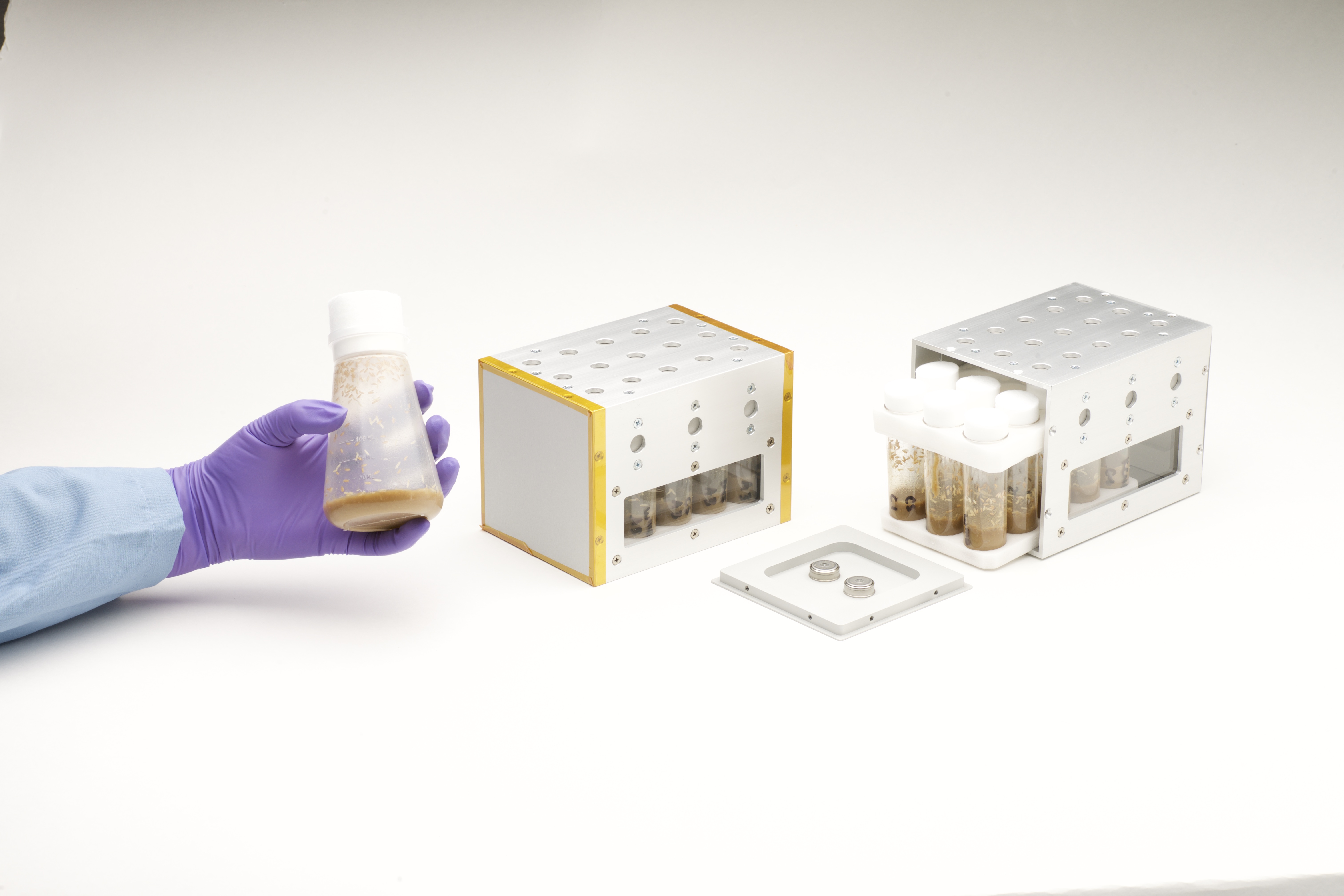
NASA Provides Hardware for Space Station DNA Repair Experiment
When it comes to helping NASA scientists better understand the effects of space travel on the human body, fruit flies are the heavyweights of experiments in weightlessness. Because humans and fruit flies share a lot of similar genetic code, they squeeze a lot of scientific value into a conveniently small, light package.
Through a new Space Act Agreement between NASA and Axiom Space, the Vented Fly Box will enable fruit flies (Drosophila melanogaster) to launch aboard a SpaceX Dragon spacecraft from NASA’s Kennedy Space Center in Florida. These tiny crew members will join the Axiom Mission 4 crew for scientific investigations on the International Space Station. The goal is to advance research into how spaceflight impacts DNA repair, a key factor in astronaut health on long-term space missions.
For decades, NASA has iterated and improved these specialized habitats to safely house generations of fruit flies for their trips to and from space. As the go-to organism for many of its studies, NASA gained unique knowledge and carefully finessed the steps astronauts take to perform the most efficient and rewarding life science experiments in space.
The study is supported by NASA’s Ames Research Center in California’s Silicon Valley and Axiom Space.
