
NASA
NASA’s Ready-to-Use Dataset Details Land Motion Across North America
An online tool maps measurements and enables non-experts to understand earthquakes, subsidence, landslides, and other types of land motion.
NASA is collaborating with the Alaska Satellite Facility in Fairbanks to create a powerful web-based tool that will show the movement of land across North America down to less than an inch. The online portal and its underlying dataset unlock a trove of satellite radar measurements that can help anyone identify where and by how much the land beneath their feet may be moving — whether from earthquakes, volcanoes, landslides, or the extraction of underground natural resources such as groundwater.
Spearheaded by NASA’s Observational Products for End-Users from Remote Sensing Analysis (OPERA) project at the agency’s Jet Propulsion Laboratory in Southern California, the effort equips users with information that would otherwise take years of training to produce. The project builds on measurements from spaceborne synthetic aperture radars, or SARs, to generate high-resolution data on how Earth’s surface is moving.
Formally called the North America Surface Displacement Product Suite, the new dataset comes ready to use with measurements dating to 2016, and the portal allows users to view those measurements at a local, state, and regional scales in a few seconds. For someone not using the dataset or website, it could take days or longer to do a similar analysis.
“You can zoom in to your country, your state, your city block, and look at how the land there is moving over time,” said David Bekaert, the OPERA project manager and a JPL radar scientist. “You can see that by a simple mouse click.”
The portal currently includes measurements for millions of pixels across the U.S. Southwest, northern Mexico, and the New York metropolitan region, each representing a 200-foot-by-200-foot (60-meter-by-60-meter) area on the ground. By the end of 2025, OPERA will add data to cover the rest of the United States, Central America, and Canada within 120 miles (200 kilometers) of the U.S. border. When a user clicks on a pixel, the system pulls measurements from hundreds of files to create a graph visualizing the land surface’s cumulative movement over time.
The OPERA portal shows how land is sinking in Freshkills Park, which is being built on the site of a former landfill on Staten Island, New York. Landfills tend to sink over time as waste decomposes and settles. The blue dot marks the spot where the portal is showing movement in the graph.Alaska Satellite Facility Land is rising at the Colorado River’s outlet to the Gulf of California, as indicated in this screenshot from the OPERA portal. The uplift is due to the sediment from the river building up over time. The graph shows that the land at the blue dot has risen about 8 inches (20 centimeters) since 2016.Alaska Satellite Facility The OPERA portal shows that land near Willcox, Arizona, subsided about 8 inches (20 centimeters) since between 2016 and 2021, in large part due to groundwater pumping. The region is part of an area being managed by state water officials.Alaska Satellite Facility“The OPERA project automated the end-to-end SAR data processing system such that users and decision-makers can focus on discovering where the land surface may be moving in their areas of interest,” said Gerald Bawden, program scientist responsible for OPERA at NASA Headquarters in Washington. “This will provide a significant advancement in identifying and understanding potential threats to the end users, while providing cost and time savings for agencies.”
For example, water-management bureaus and state geological surveys will be able to directly use the OPERA products without needing to make big investments in data storage, software engineering expertise, and computing muscle.
How It WorksTo create the displacement product, the OPERA team continuously draws data from the ESA (European Space Agency) Sentinel-1 radar satellites, the first of which launched in 2014. Data from NISAR, the NASA-ISRO (Indian Space Research Organisation) Synthetic Aperture Radar mission, will be added to the mix after that spacecraft launches later this year.
Satellite-borne radars work by emitting microwave pulses at Earth’s surface. The signals scatter when they hit land and water surfaces, buildings, and other objects. Raw data consists of the strength and time delay of the signals that echo back to the sensor.
To understand how land in a given area is moving, OPERA algorithms automate steps in an otherwise painstaking process. Without OPERA, a researcher would first download hundreds or thousands of data files, each representing a pass of the radar over the point of interest, then make sure the data aligned geographically over time and had precise coordinates.
Then they would use a computationally intensive technique called radar interferometry to gauge how much the land moved, if at all, and in which direction — towards the satellite, which would indicate the land rose, or away from the satellite, which would mean it sank.
“The OPERA project has helped bring that capability to the masses, making it more accessible to state and federal agencies, and also users wondering, ‘What’s going on around my house?’” said Franz Meyer, chief scientist of the Alaska Satellite Facility, a part of the University of Alaska Fairbanks Geophysical Institute.
Monitoring GroundwaterSinking land is a top priority to the Arizona Department of Water Resources. From the 1950s through the 1980s, it was the main form of ground movement officials saw, as groundwater pumping increased alongside growth in the state’s population and agricultural industry. In 1980, the state enacted the Groundwater Management Act, which reduced its reliance on groundwater in highly populated areas and included requirements to monitor its use.
The department began to measure this sinking, called subsidence, with radar data from various satellites in the early 2000s, using a combination of SAR, GPS-based monitoring, and traditional surveying to inform groundwater-management decisions.
Now, the OPERA dataset and portal will help the agency share subsidence information with officials and community members, said Brian Conway, the department’s principal hydrogeologist and supervisor of its geophysics unit. They won’t replace the SAR analysis he performs, but they will offer points of comparison for his calculations. Because the dataset and portal will cover the entire state, they also could identify areas not yet known to be subsiding.
“It’s a great tool to say, ‘Let’s look at those areas more intensely with our own SAR processing,’” Conway said.
The displacement product is part of a series of data products OPERA has released since 2023. The project began in 2020 with a multidisciplinary team of scientists at JPL working to address satellite data needs across different federal agencies. Through the Satellite Needs Working Group, those agencies submitted their requests, and the OPERA team worked to improve access to information to aid a range of efforts such as disaster response, deforestation tracking, and wildfire monitoring.
NASA-Led Project Tracking Changes to Water, Ecosystems, Land Surface News Media ContactsAndrew Wang / Jane J. Lee
Jet Propulsion Laboratory, Pasadena, Calif.
626-379-6874 / 818-354-0307
andrew.wang@jpl.nasa.gov / jane.j.lee@jpl.nasa.gov
2025-076
Share Details Last Updated Jun 06, 2025 Related Terms Explore More 4 min read NASA Mars Orbiter Captures Volcano Peeking Above Morning Cloud Tops Article 10 hours ago 8 min read ICESat-2 Applications Team Hosts Satellite Bathymetry WorkshopIntroduction On September 15, 2018, the NASA Ice, Cloud, and land Elevation Satellite-2 (ICESat-2) mission…
Article 1 day ago 5 min read Jack Kaye Retires After a Storied Career at NASAJack Kaye [NASA HQ—Associate Director for Research, Earth Science Division (ESD)] has decided to retire…
Article 2 days ago Keep Exploring Discover More Topics From NASAMissions
Humans in Space
Climate Change
Solar System
NASA Provides Hardware for Space Station DNA Repair Experiment
When it comes to helping NASA scientists better understand the effects of space travel on the human body, fruit flies are the heavyweights of experiments in weightlessness. Because humans and fruit flies share a lot of similar genetic code, they squeeze a lot of scientific value into a conveniently small, light package.
Through a new Space Act Agreement between NASA and Axiom Space, the Vented Fly Box will enable fruit flies (Drosophila melanogaster) to launch aboard a SpaceX Dragon spacecraft from NASA’s Kennedy Space Center in Florida. These tiny crew members will join the Axiom Mission 4 crew for scientific investigations on the International Space Station. The goal is to advance research into how spaceflight impacts DNA repair, a key factor in astronaut health on long-term space missions.
For decades, NASA has iterated and improved these specialized habitats to safely house generations of fruit flies for their trips to and from space. As the go-to organism for many of its studies, NASA gained unique knowledge and carefully finessed the steps astronauts take to perform the most efficient and rewarding life science experiments in space.
The study is supported by NASA’s Ames Research Center in California’s Silicon Valley and Axiom Space.
ARMD Research Solicitations (Updated June 6)
9 min read
Preparations for Next Moonwalk Simulations Underway (and Underwater) NASA / Lillian Gipson/Getty ImagesTHIS PAGE WAS UPDATED ON JUNE 6, 2025
(Updated Advanced Air Vehicles Program Fellowship Opportunities.)
This Aeronautics Research Mission Directorate (ARMD) solicitations page compiles the opportunities to collaborate with NASA’s aeronautical innovators and/or contribute to their research to enable new and improved air transportation systems.
Most opportunities to participate in research are officially announced through the Web-based NASA Solicitation and Proposal Integrated Review and Evaluation System, better known as NSPIRES. You are encouraged to visit the NSPIRES web site, create an account, and sign up for automated email announcements.
Other types of collaborative opportunities, such as those involving Requests for Information or academic research contests, also are included on this page.
This page has four major sections:
- Quick list of open solicitations with key dates listed.
- Current open solicitations with more details and helpful links.
- Closed solicitations in case it is helpful to see other examples of the kind of research opportunities NASA Aeronautics makes available.
- Summary of NASA’s Research Opportunities in Aeronautics (ROA) NASA Research Announcement (NRA) selection process.
Advanced Air Vehicles Program Fellowship Opportunities
Proposals are due by June 11, 2025. (NOTE important update below.)
University Leadership Initiative
Step-A proposals due by June 26, 2025.
University Student Research Challenge
Proposals for Cycle 3 are due by June 26, 2025.
Advanced Air Vehicles Program Fellowship Opportunities
(View the full ROA-2025 NRA Amendment 1 text here.)
This announcement solicits proposals from accredited U.S. institutions for research training grants to begin the academic year. This Notice of Funding Opportunity is designed to support independently conceived research projects by highly qualified graduate students in disciplines needed to help advance NASA’s mission, thus affording these students the opportunity to directly contribute to advancements in STEM-related areas of study. These opportunities are focused on innovation and the generation of measurable research results that contribute to NASA’s current and future science and technology goals.
Research proposals are sought to address the key challenges summarized in the Elements section at the end of the Amendment 1 document, and which reference NASA’s Hypersonic Technology project.
UPDATE for June 6: Reflecting the Fiscal Year 2026 budget changes, the Transformational Tools & Technologies project opportunities originally described in this announcement were cancelled. Proposals citing this project will not be evaluated.
Notices of Intent are not required.
A budget breakdown for each proposal is required, detailing the allocation of the award funds by year. The budget document may adhere to any format or template provided by the applicant’s institution. Two pre-proposal teleconferences for potential proposers will be held and meeting links will be posted on NSPIRES.
Proposals are due by 5 p.m. EDT on June 11, 2025.
uli-2025-graphicNASA / Lillian Gipson ROA-2024 NRA Amendment 2 – OPENUniversity Leadership Initiative
(View the full ROA-2024 NRA Amendment 2 text here.)
NASA’s University Leadership Initiative (ULI) provides the opportunity for university teams to exercise technical and organizational leadership in proposing unique technical challenges in aeronautics, defining multi-disciplinary solutions, establishing peer review mechanisms, and applying innovative teaming strategies to strengthen the research impact.
Research proposals are sought in six ULI topic areas in Appendix D.4.
Topic 1: Safe, Efficient Growth in Global Operations
Topic 2: Innovation in Commercial High-Speed Aircraft
Topic 3: Ultra-Efficient Subsonic Transports
Topic 4: Safe, Quiet, and Affordable Vertical Lift Air Vehicles
Topic 5: In-Time System-Wide Safety Assurance
Topic 6: Assured Autonomy for Aviation Transformation
This NASA Research Announcement will utilize a two-step proposal submission and evaluation process. The initial step is a short mandatory Step-A proposal, which is due June 26, 2025. Those offerors submitting the most highly rated Step-A proposals will be invited to submit a Step-B proposal. All proposals must be submitted electronically through NSPIRES at https://nspires.nasaprs.com. An Applicant’s Workshop will be held on Thursday April 30, 2025; 1:00-3:00 p.m. ET (https://uli.arc.nasa.gov/applicants-workshops/workshop9) (Page will be live closer to the event.)
An interested partners list for this ULI is at https://uli.arc.nasa.gov/partners. To be listed as an interested lead or partner, please send an email to hq-univpartnerships@mail.nasa.gov with “ULI Partnerships” in the subject line and include the information required for the table on that web page.
Getty Images ROA-2024 NRA Amendment 4 – OPENUniversity Student Research Challenge
(View the full ROA-2024 NRA Amendment 4 text here)
NASA’s University Student Research Challenge (USRC) seeks to challenge students to propose new ideas/concepts that are relevant to NASA Aeronautics. The challenge will provide students from accredited U.S. colleges or universities with grants for their projects, as well as the challenge of raising cost share funds through a crowdfunding campaign. The process of creating and implementing a crowdfunding campaign acts as a teaching accelerator — requiring students to act like entrepreneurs and raise awareness about their research among the public.
The solicitation goal can be accomplished through project ideas such as advancing the design, developing technology or capabilities in support of aviation, by demonstrating a novel concept, or enabling advancement of aeronautics-related technologies.
Notices of Intent are not required for this solicitation.
Proposals for Cycle 3 are due June 26, 2025.
Proposals can also be submitted later and evaluated in the second and third cycles.
The USRC Q&A/Info Session and Proposal Workshop will be held on the days/times below. Please join us on TEAMS using the Meeting Link, or call in via +1 256-715-9946,,317928116#.
USRC CycleInformation Session/Q&A DateProposal Due DateCycle 1Sept. 20, 2024 at 2 pm ETNov. 7, 2024Cycle 2Jan. 27, 2025 at 2 pm ETMarch 13, 2025Cycle 3May 12, 2025 at 2 pm ETJune 26, 2025 The Project F.I.R.E. team receives their “Future Game-Changer” award during the 2024 Gateways to Blue Skies forum held at NASA’s Ames Research Center in California. Gateways to Blue Skies is one of several Aeronautics Innovation Challenges open to the academic community.NASA / Brandon Torres Aeronautics Innovation Challenges – OPENNASA’s nationwide team of aeronautical innovators are committed to giving students of all ages opportunities to solve some of the biggest technical challenges facing the aviation community today. Through NASA-sponsored challenges and competitions, students representing multiple disciplines will put their skills to work by designing and building solutions to real-world problems.
See the Complete List of Challenges Currently Closed Solicitations Advanced Capabilities for Emergency Response Operations RFI – CLOSEDView the full ACERO RFI announcement here.
NASA’s Advanced Capabilities for Emergency Response Operations (ACERO) project used this request for information to identify technologies that addressed current challenges facing the wildland firefighting community. NASA was seeking information on data collection, airborne connectivity and communications solutions, unmanned aircraft systems traffic management, aircraft operations and autonomy, and more. This would support development of a partnership strategy for future collaborative demonstrations.
Interested parties were requested to respond to this notice with an information package submitted via https://nari.arc.nasa.gov/acero-rfi no later than 4 pm ET, October 15, 2023. Submissions were accepted only from U.S. companies.
Advanced Air Mobility Mission RFI – CLOSEDView the full AAM RFI announcement here.
This request for information is being used to gather market research for NASA to make informed decisions regarding potential partnership strategies and future research to enable Advanced Air Mobility (AAM). NASA is seeking information from public, private, and academic organizations to determine technical needs and community interests that may lead to future solicitations regarding AAM research and development.
This particular RFI is just one avenue of multiple planned opportunities for formal feedback on or participation in NASA’s AAM Mission-related efforts to develop these requirements and help enable AAM.
The respond by date for this RFI closed on Feb. 1, 2025, at 6 p.m. EST.
ROA-2024 NRA Amendment 1 – CLOSED(View the full ROA-2024 NRA Amendment 1 text here.)
The announcement solicited proposals from accredited U.S. institutions for research training grants to begin the academic year. This Notice of Funding Opportunity was designed to support independently conceived research projects by highly qualified graduate students, in disciplines needed to help advance NASA’s mission, thus affording these students the opportunity to directly contribute to advancements in STEM-related areas of study. Advanced Air Vehicle Program fellowship opportunities are focused on innovation and the generation of measurable research results that contribute to NASA’s current and future science and technology goals.
Research proposals were sought to address key challenges provided in Elements of Appendix A.8.
A budget breakdown for each proposal was required, detailing the allocation of the award funds by year. The budget document could adhere to any format or template provided by the applicant’s institution.
Proposals were due by April 30, 2024, at 5 PM ET.
ROA-2024 NRA Amendment 3 – CLOSED(View the full ROA-2024 NRA Amendment 3 text here)
NASA’s Commercial Supersonic Technology project sought proposals for a fuel injector design concept and fabrication for testing at NASA’s Glenn Research Center in Cleveland.
The proposal for the fuel injector design aimed to establish current state-of-the-art in low NOx supersonic cruise while meeting reasonable landing take-off NOx emissions. The technology application timeline is targeted for a supersonic aircraft with entry into service in the 2035+ timeframe.
Proposals were due by May 31, 2024 at 5 pm EDT.
NASA Research Opportunities in AeronauticsCompetition for NRA awards is open to both academia and industry.
The current open solicitations for ARMD Research Opportunities are ROA-2024 and ROA-2025.
Here is some general information to know about the NRA process.
- NRA solicitations are released by NASA Headquarters through the Web-based NASA Solicitation and Proposal Integrated Review and Evaluation System (NSPIRES).
- All NRA technical work is defined and managed by project teams within these four programs: Advanced Air Vehicles Program, Airspace Operations and Safety Program, Integrated Aviation Systems Program, and Transformative Aeronautics Concepts Program.
- NRA awards originate from NASA’s Langley Research Center in Virginia, Ames Research Center in California, Glenn Research Center in Cleveland, and Armstrong Flight Research Center in California.
- Competition for NRA awards is full and open.
- Participation is open to all categories of organizations, including educational institutions, industry, and nonprofits.
- Any updates or amendments to an NRA is posted on the appropriate NSPIRES web pages as noted in the Amendments detailed below.
- ARMD sends notifications of NRA updates through the NSPIRES email system. In order to receive these email notifications, you must be a Registered User of NSPIRES. However, note that NASA is not responsible for inadvertently failing to provide notification of a future NRA. Parties are responsible for regularly checking the NSPIRES website for updated NRAs.
Aeronautics STEM
Aeronautics Research Mission Directorate
The National Advisory Committee for Aeronautics (NACA)
Aeronáutica en español
Share Details Last Updated Jun 06, 2025 EditorJim BankeContactJim Bankejim.banke@nasa.gov Related TermsARMD Research Solicitations (Updated June 6)
9 min read
Preparations for Next Moonwalk Simulations Underway (and Underwater) NASA / Lillian Gipson/Getty ImagesTHIS PAGE WAS UPDATED ON JUNE 6, 2025
(Updated Advanced Air Vehicles Program Fellowship Opportunities.)
This Aeronautics Research Mission Directorate (ARMD) solicitations page compiles the opportunities to collaborate with NASA’s aeronautical innovators and/or contribute to their research to enable new and improved air transportation systems.
Most opportunities to participate in research are officially announced through the Web-based NASA Solicitation and Proposal Integrated Review and Evaluation System, better known as NSPIRES. You are encouraged to visit the NSPIRES web site, create an account, and sign up for automated email announcements.
Other types of collaborative opportunities, such as those involving Requests for Information or academic research contests, also are included on this page.
This page has four major sections:
- Quick list of open solicitations with key dates listed.
- Current open solicitations with more details and helpful links.
- Closed solicitations in case it is helpful to see other examples of the kind of research opportunities NASA Aeronautics makes available.
- Summary of NASA’s Research Opportunities in Aeronautics (ROA) NASA Research Announcement (NRA) selection process.
Advanced Air Vehicles Program Fellowship Opportunities
Proposals are due by June 11, 2025. (NOTE important update below.)
University Leadership Initiative
Step-A proposals due by June 26, 2025.
University Student Research Challenge
Proposals for Cycle 3 are due by June 26, 2025.
Advanced Air Vehicles Program Fellowship Opportunities
(View the full ROA-2025 NRA Amendment 1 text here.)
This announcement solicits proposals from accredited U.S. institutions for research training grants to begin the academic year. This Notice of Funding Opportunity is designed to support independently conceived research projects by highly qualified graduate students in disciplines needed to help advance NASA’s mission, thus affording these students the opportunity to directly contribute to advancements in STEM-related areas of study. These opportunities are focused on innovation and the generation of measurable research results that contribute to NASA’s current and future science and technology goals.
Research proposals are sought to address the key challenges summarized in the Elements section at the end of the Amendment 1 document, and which reference NASA’s Hypersonic Technology project.
UPDATE for June 6: Reflecting the Fiscal Year 2026 budget changes, the Transformational Tools & Technologies project opportunities originally described in this announcement were cancelled. Proposals citing this project will not be evaluated.
Notices of Intent are not required.
A budget breakdown for each proposal is required, detailing the allocation of the award funds by year. The budget document may adhere to any format or template provided by the applicant’s institution. Two pre-proposal teleconferences for potential proposers will be held and meeting links will be posted on NSPIRES.
Proposals are due by 5 p.m. EDT on June 11, 2025.
uli-2025-graphicNASA / Lillian Gipson ROA-2024 NRA Amendment 2 – OPENUniversity Leadership Initiative
(View the full ROA-2024 NRA Amendment 2 text here.)
NASA’s University Leadership Initiative (ULI) provides the opportunity for university teams to exercise technical and organizational leadership in proposing unique technical challenges in aeronautics, defining multi-disciplinary solutions, establishing peer review mechanisms, and applying innovative teaming strategies to strengthen the research impact.
Research proposals are sought in six ULI topic areas in Appendix D.4.
Topic 1: Safe, Efficient Growth in Global Operations
Topic 2: Innovation in Commercial High-Speed Aircraft
Topic 3: Ultra-Efficient Subsonic Transports
Topic 4: Safe, Quiet, and Affordable Vertical Lift Air Vehicles
Topic 5: In-Time System-Wide Safety Assurance
Topic 6: Assured Autonomy for Aviation Transformation
This NASA Research Announcement will utilize a two-step proposal submission and evaluation process. The initial step is a short mandatory Step-A proposal, which is due June 26, 2025. Those offerors submitting the most highly rated Step-A proposals will be invited to submit a Step-B proposal. All proposals must be submitted electronically through NSPIRES at https://nspires.nasaprs.com. An Applicant’s Workshop will be held on Thursday April 30, 2025; 1:00-3:00 p.m. ET (https://uli.arc.nasa.gov/applicants-workshops/workshop9) (Page will be live closer to the event.)
An interested partners list for this ULI is at https://uli.arc.nasa.gov/partners. To be listed as an interested lead or partner, please send an email to hq-univpartnerships@mail.nasa.gov with “ULI Partnerships” in the subject line and include the information required for the table on that web page.
Getty Images ROA-2024 NRA Amendment 4 – OPENUniversity Student Research Challenge
(View the full ROA-2024 NRA Amendment 4 text here)
NASA’s University Student Research Challenge (USRC) seeks to challenge students to propose new ideas/concepts that are relevant to NASA Aeronautics. The challenge will provide students from accredited U.S. colleges or universities with grants for their projects, as well as the challenge of raising cost share funds through a crowdfunding campaign. The process of creating and implementing a crowdfunding campaign acts as a teaching accelerator — requiring students to act like entrepreneurs and raise awareness about their research among the public.
The solicitation goal can be accomplished through project ideas such as advancing the design, developing technology or capabilities in support of aviation, by demonstrating a novel concept, or enabling advancement of aeronautics-related technologies.
Notices of Intent are not required for this solicitation.
Proposals for Cycle 3 are due June 26, 2025.
Proposals can also be submitted later and evaluated in the second and third cycles.
The USRC Q&A/Info Session and Proposal Workshop will be held on the days/times below. Please join us on TEAMS using the Meeting Link, or call in via +1 256-715-9946,,317928116#.
USRC CycleInformation Session/Q&A DateProposal Due DateCycle 1Sept. 20, 2024 at 2 pm ETNov. 7, 2024Cycle 2Jan. 27, 2025 at 2 pm ETMarch 13, 2025Cycle 3May 12, 2025 at 2 pm ETJune 26, 2025 The Project F.I.R.E. team receives their “Future Game-Changer” award during the 2024 Gateways to Blue Skies forum held at NASA’s Ames Research Center in California. Gateways to Blue Skies is one of several Aeronautics Innovation Challenges open to the academic community.NASA / Brandon Torres Aeronautics Innovation Challenges – OPENNASA’s nationwide team of aeronautical innovators are committed to giving students of all ages opportunities to solve some of the biggest technical challenges facing the aviation community today. Through NASA-sponsored challenges and competitions, students representing multiple disciplines will put their skills to work by designing and building solutions to real-world problems.
See the Complete List of Challenges Currently Closed Solicitations Advanced Capabilities for Emergency Response Operations RFI – CLOSEDView the full ACERO RFI announcement here.
NASA’s Advanced Capabilities for Emergency Response Operations (ACERO) project used this request for information to identify technologies that addressed current challenges facing the wildland firefighting community. NASA was seeking information on data collection, airborne connectivity and communications solutions, unmanned aircraft systems traffic management, aircraft operations and autonomy, and more. This would support development of a partnership strategy for future collaborative demonstrations.
Interested parties were requested to respond to this notice with an information package submitted via https://nari.arc.nasa.gov/acero-rfi no later than 4 pm ET, October 15, 2023. Submissions were accepted only from U.S. companies.
Advanced Air Mobility Mission RFI – CLOSEDView the full AAM RFI announcement here.
This request for information is being used to gather market research for NASA to make informed decisions regarding potential partnership strategies and future research to enable Advanced Air Mobility (AAM). NASA is seeking information from public, private, and academic organizations to determine technical needs and community interests that may lead to future solicitations regarding AAM research and development.
This particular RFI is just one avenue of multiple planned opportunities for formal feedback on or participation in NASA’s AAM Mission-related efforts to develop these requirements and help enable AAM.
The respond by date for this RFI closed on Feb. 1, 2025, at 6 p.m. EST.
ROA-2024 NRA Amendment 1 – CLOSED(View the full ROA-2024 NRA Amendment 1 text here.)
The announcement solicited proposals from accredited U.S. institutions for research training grants to begin the academic year. This Notice of Funding Opportunity was designed to support independently conceived research projects by highly qualified graduate students, in disciplines needed to help advance NASA’s mission, thus affording these students the opportunity to directly contribute to advancements in STEM-related areas of study. Advanced Air Vehicle Program fellowship opportunities are focused on innovation and the generation of measurable research results that contribute to NASA’s current and future science and technology goals.
Research proposals were sought to address key challenges provided in Elements of Appendix A.8.
A budget breakdown for each proposal was required, detailing the allocation of the award funds by year. The budget document could adhere to any format or template provided by the applicant’s institution.
Proposals were due by April 30, 2024, at 5 PM ET.
ROA-2024 NRA Amendment 3 – CLOSED(View the full ROA-2024 NRA Amendment 3 text here)
NASA’s Commercial Supersonic Technology project sought proposals for a fuel injector design concept and fabrication for testing at NASA’s Glenn Research Center in Cleveland.
The proposal for the fuel injector design aimed to establish current state-of-the-art in low NOx supersonic cruise while meeting reasonable landing take-off NOx emissions. The technology application timeline is targeted for a supersonic aircraft with entry into service in the 2035+ timeframe.
Proposals were due by May 31, 2024 at 5 pm EDT.
NASA Research Opportunities in AeronauticsCompetition for NRA awards is open to both academia and industry.
The current open solicitations for ARMD Research Opportunities are ROA-2024 and ROA-2025.
Here is some general information to know about the NRA process.
- NRA solicitations are released by NASA Headquarters through the Web-based NASA Solicitation and Proposal Integrated Review and Evaluation System (NSPIRES).
- All NRA technical work is defined and managed by project teams within these four programs: Advanced Air Vehicles Program, Airspace Operations and Safety Program, Integrated Aviation Systems Program, and Transformative Aeronautics Concepts Program.
- NRA awards originate from NASA’s Langley Research Center in Virginia, Ames Research Center in California, Glenn Research Center in Cleveland, and Armstrong Flight Research Center in California.
- Competition for NRA awards is full and open.
- Participation is open to all categories of organizations, including educational institutions, industry, and nonprofits.
- Any updates or amendments to an NRA is posted on the appropriate NSPIRES web pages as noted in the Amendments detailed below.
- ARMD sends notifications of NRA updates through the NSPIRES email system. In order to receive these email notifications, you must be a Registered User of NSPIRES. However, note that NASA is not responsible for inadvertently failing to provide notification of a future NRA. Parties are responsible for regularly checking the NSPIRES website for updated NRAs.
Aeronautics STEM
Aeronautics Research Mission Directorate
The National Advisory Committee for Aeronautics (NACA)
Aeronáutica en español
Share Details Last Updated Jun 06, 2025 EditorJim BankeContactJim Bankejim.banke@nasa.gov Related TermsHubble Captures Starry Spectacle
- Hubble Home
- Overview
- Impact & Benefits
- Science
- Observatory
- Team
- Multimedia
- News
- More
2 min read
Hubble Captures Starry Spectacle This NASA/ESA Hubble Space Telescope image features the barred spiral galaxy NGC 685.ESA/Hubble & NASA, J. Lee, F. BelfioreA galaxy ablaze with young stars is the subject of this NASA/ESA Hubble Space Telescope image. Named NGC 685, this galaxy is situated about 64 million light-years away in the constellation Eridanus (the River). NGC 685 is a barred spiral because its feathery spiral arms sprout from the ends of a bar of stars at the galaxy’s center. The Milky Way is also a barred spiral, but our galaxy is a little less than twice the size of NGC 685.
Astronomers used Hubble to study NGC 685 for two observing programs, both focused on star formation. It’s no surprise that NGC 685 was part of these programs: numerous patches of young, blue stars highlight the galaxy’s spiral arms. Also visible are pink gas clouds, called H II (pronounced ‘H-two’) regions, that glow for a short time when particularly hot and massive stars are born. An especially eye-catching H II region peeks out at the bottom edge of the image. Despite the dozens of star-forming regions evident in this image, NGC 685 converts an amount of gas equivalent to less than half the mass of the Sun into stars each year.
The Hubble data collected for the two observing programs will allow astronomers to catalogue 50,000 H II regions and 100,000 star clusters in nearby galaxies. By combining Hubble’s sensitive visible and ultraviolet observations with infrared data from the NASA/ESA/CSA James Webb Space Telescope and radio data from the Atacama Large Millimeter/submillimeter Array, researchers can peer into the depths of dusty stellar nurseries and illuminate the stars forming there.
Text Credit: ESA/Hubble
Facebook logo @NASAHubble @NASAHubble Instagram logo @NASAHubbleMedia Contact:
Claire Andreoli (claire.andreoli@nasa.gov)
NASA’s Goddard Space Flight Center, Greenbelt, MD
Since its 1990 launch, the Hubble Space Telescope has changed our fundamental understanding of the universe.
Hubble’s Galaxies
3D Hubble Models
Hubble’s Night Sky Challenge
Hubble Captures Starry Spectacle
- Hubble Home
- Overview
- Impact & Benefits
- Science
- Observatory
- Team
- Multimedia
- News
- More
2 min read
Hubble Captures Starry Spectacle This NASA/ESA Hubble Space Telescope image features the barred spiral galaxy NGC 685.ESA/Hubble & NASA, J. Lee, F. BelfioreA galaxy ablaze with young stars is the subject of this NASA/ESA Hubble Space Telescope image. Named NGC 685, this galaxy is situated about 64 million light-years away in the constellation Eridanus (the River). NGC 685 is a barred spiral because its feathery spiral arms sprout from the ends of a bar of stars at the galaxy’s center. The Milky Way is also a barred spiral, but our galaxy is a little less than twice the size of NGC 685.
Astronomers used Hubble to study NGC 685 for two observing programs, both focused on star formation. It’s no surprise that NGC 685 was part of these programs: numerous patches of young, blue stars highlight the galaxy’s spiral arms. Also visible are pink gas clouds, called H II (pronounced ‘H-two’) regions, that glow for a short time when particularly hot and massive stars are born. An especially eye-catching H II region peeks out at the bottom edge of the image. Despite the dozens of star-forming regions evident in this image, NGC 685 converts an amount of gas equivalent to less than half the mass of the Sun into stars each year.
The Hubble data collected for the two observing programs will allow astronomers to catalogue 50,000 H II regions and 100,000 star clusters in nearby galaxies. By combining Hubble’s sensitive visible and ultraviolet observations with infrared data from the NASA/ESA/CSA James Webb Space Telescope and radio data from the Atacama Large Millimeter/submillimeter Array, researchers can peer into the depths of dusty stellar nurseries and illuminate the stars forming there.
Text Credit: ESA/Hubble
Facebook logo @NASAHubble @NASAHubble Instagram logo @NASAHubbleMedia Contact:
Claire Andreoli (claire.andreoli@nasa.gov)
NASA’s Goddard Space Flight Center, Greenbelt, MD
Since its 1990 launch, the Hubble Space Telescope has changed our fundamental understanding of the universe.
Hubble’s Galaxies
3D Hubble Models
Hubble’s Night Sky Challenge
NASA Awards Third Crowdsourcing Contract Iteration
Editor’s note: This release was updated June 6, 2025, to correct the name of one of the awardees.
NASA continues to collaborate with global communities to solve complex challenges through crowdsourcing with a series of 25 new NASA Open Innovation Service (NOIS) contracts managed by the agency’s Johnson Space Center in Houston.
The contract aims to empower NASA’s workforce by actively engaging the public to find creative solutions to difficult space exploration challenges through rapid experimentation with new methodologies, new technologies, and unique perspectives, ensuring NASA remains at the forefront of innovation while accomplishing its missions.
This is the third NOIS contract, managed by NASA’s Center of Excellence for Collaborative Innovation (CoECI), and used by NASA and other government agencies. The NOIS3 contract will provide solutions through multiple crowdsourcing tools and methodologies, which include public prize competitions, freelance tasking, technology searches, and other crowd-based methods.
The total value of the NOIS3 contract is $475 million over 10 years. There is a guaranteed $500 minimum obligation for each contract award. The base contract spans June 5, 2025, through May 31, 2027, and there are two options, the first for three years, and the second for five years. If all options are exercised, work could continue through May 31, 2035.
The awardees are:
- Blue Clarity, Vienna, Virginia
- Capital Consulting Corp., Fairfax, Virginia
- Challenge Works, London, United Kingdom
- CrowdPlat Inc., Pleasanton, California
- Design Interactive Inc., Orlando, Florida
- DrivenData Inc., Denver
- Ensemble Government Services, Hyattsville, Maryland
- Hyperion Technologies, Arlington, Virginia
- Floor23 Digital, Jackson, Wisconsin
- Freelancer International, Sydney, Australia
- HeroX, Wilmington, Delaware
- HYVE Innovate, Munchen, Germany
- Innoget, Rockville, Maryland
- Institute of Competition Sciences, San Francisco
- Loyal Source Government Services, Orlando, Florida
- Luminary Labs, New York City
- National Institute of Aerospace Associates, Hampton, Virginia
- Randstad Federal, Duluth, Georgia
- Rios Partners, Arlington, Virginia
- SecondMuse, Bernalillo, New Mexico
- TechConnect, Summerville, South Carolina
- Toffler Associates, Arlington, Virginia
- Tongal Inc., Los Angeles
- Topcoder, Indianapolis
- yet2.com Inc., Waltham, Massachusetts
NASA’s CoECI provides guidance on open innovation initiatives, helping define challenges and requirements and formulating and evaluating potential solutions. The center’s end-to-end service allows NASA and other federal agencies to rapidly experiment with new methods and solve critical problems through innovation and collaboration.
Learn more about the NASA Center of Excellence at:
-end-
Tiernan Doyle
Headquarters, Washington
202-358-1600
tiernan.doyle@nasa.gov
Kelly Humphries
Johnson Space Center, Houston
281-483-5111
kelly.o.humphries@nasa.gov
Auburn Team Wins 2025 NASA Moon and Mars Design Competition
4 min read
Preparations for Next Moonwalk Simulations Underway (and Underwater) Auburn University’s project, “Dynamic Ecosystems for Mars ECLSS Testing, Evaluation, and Reliability (DEMETER),” won top prize in NASA’s 2025 Revolutionary Aerospace Systems – Academic Linkage (RASC-AL) Competition Forum. National Institute of AerospaceA team from Auburn University took top honors in NASA’s 2025 Revolutionary Aerospace Systems – Academic Linkage (RASC-AL) Competition Forum, where undergraduate and graduate teams competed to develop new concepts for operating on the Moon, Mars and beyond.
Auburn’s project, “Dynamic Ecosystems for Mars Environmental Control and Life Support Systems (ECLSS) Testing, Evaluation, and Reliability (DEMETER)” advised by Dr. Davide Guzzetti, took home top prize out of 14 Finalist Teams from academic institutions across the nation. Virginia Polytechnic Institute and State University took second place overall for their concept, “Adaptive Device for Assistance and Maintenance (ADAM),” advised by Dr. Kevin Shinpaugh. The University of Maryland took third place overall with their project, “Servicing Crane Outfitted Rover for Payloads, Inspection, Operations, N’stuff (SCORPION),” advised by Dr. David Akin, Nich Bolatto, and Charlie Hanner.
The first and second place overall winning teams will present their work at the 2025 AIAA Accelerating Space Commerce, Exploration, and New Discovery (ASCEND) Conference in Las Vegas, Nevada in July.
Virginia Polytechnic Institute and State University took second place overall in NASA’s 2025 Revolutionary Aerospace Systems – Academic Linkage (RASC-AL) Competition Forum for their concept, “Adaptive Device for Assistance and Maintenance (ADAM).”National Institute of AerospaceThe RASC-AL Competition, which took place from June 2-4, 2025, in Cocoa Beach, Florida, is a unique initiative designed to bridge the gap between academia and the aerospace industry, empowering undergraduate and graduate students to apply their classroom knowledge to real-world challenges in space exploration. This year’s themes included “Sustained Lunar Evolution – An Inspirational Moment,” “Advanced Science Missions and Technology Demonstrators for Human-Mars Precursor Campaign,” and “Small Lunar Servicing and Maintenance Robot.”
“The RASC-AL Competition cultivates students who bring bold, imaginative thinking to the kinds of complex challenges we tackle at NASA,” said Dan Mazanek, RASC-AL program sponsor and senior space systems engineer at NASA’s Langley Research Center in Hampton, Virginia. “These teams push the boundaries of what’s possible in space system design and offer new insights. These insights help build critical engineering capabilities, preparing the next generation of aerospace leaders to step confidently into the future of space exploration.”
As NASA continues to push the boundaries of space exploration, the RASC-AL Competition stands as an opportunity for aspiring aerospace professionals to design real-world solutions to complex problems facing the Agency. By engaging with the next generation of innovators, NASA can collaborate with the academic community to crowd-source new solutions for the challenges of tomorrow.
Additional 2025 Forum Awards include:
Best in Theme: Sustained Lunar Evolution: An Inspirational Moment
- Virginia Polytechnic Institute and State University
- Project Title: Project Aeneas
- Advisor: Dr. Kevin Shinpaugh
Best in Theme: Advanced Science Missions and Technology Demonstrators for Human-Mars Precursor Campaign
- Auburn University
- Project Title: Dynamic Ecosystems for Mars ECLSS Testing, Evaluation, and Reliability (DEMETER)
- Advisor: Dr. Davide Guzzetti
Best in Theme: Small Lunar Servicing and Maintenance Robot
- Virginia Polytechnic Institute and State University
- Project Title: Adaptive Device for Assistance and Maintenance (ADAM)
- Advisor: Dr. Kevin Shinpaugh
Best Prototype: South Dakota State University
- Project Title: Next-gen Operations and Versatile Assistant (NOVA)
- Advisor: Dr. Todd Letcher, Allea Klauenberg, Liam Murray, Alex Schaar, Nick Sieler, Dylan Stephens, Carter Waggoner
RASC-AL is open to undergraduate and graduate students studying disciplines related to human exploration, including aerospace, bio-medical, electrical, and mechanical engineering, and life, physical, and computer sciences. RASC-AL projects allow students to incorporate their coursework into space exploration objectives in a team environment and help bridge strategic knowledge gaps associated with NASA’s vision. Students have the opportunity to interact with NASA officials and industry experts and develop relationships that could lead to participation in other NASA student research programs.
RASC-AL is sponsored by the Strategies and Architectures Office within the Exploration Systems Development Mission Directorate at NASA Headquarters, and by the Space Mission Analysis Branch within the Systems Analysis and Concepts Directorate at NASA Langley. It is administered by the National Institute of Aerospace.
For more information about the RASC-AL competition, including complete theme and submission guidelines, visit: http://rascal.nianet.org.
National Institute of Aerospace
About the AuthorJoe AtkinsonPublic Affairs Officer, NASA Langley Research Center Share Details Last Updated Jun 05, 2025 Related Terms Explore More 3 min read NASA Earth Scientist Elected to National Academy of Sciences Article 18 hours ago 3 min read I Am Artemis: Lili VillarrealLili Villarreal fell in love with space exploration from an early age when her and…
Article 2 days ago 19 min read Interview with Dave Des Marais Article 3 days ago Keep Exploring Discover More Topics From NASAMissions
Humans in Space
Climate Change
Solar System
Auburn Team Wins 2025 NASA Moon and Mars Design Competition
4 min read
Preparations for Next Moonwalk Simulations Underway (and Underwater) Auburn University’s project, “Dynamic Ecosystems for Mars ECLSS Testing, Evaluation, and Reliability (DEMETER),” won top prize in NASA’s 2025 Revolutionary Aerospace Systems – Academic Linkage (RASC-AL) Competition Forum. National Institute of AerospaceA team from Auburn University took top honors in NASA’s 2025 Revolutionary Aerospace Systems – Academic Linkage (RASC-AL) Competition Forum, where undergraduate and graduate teams competed to develop new concepts for operating on the Moon, Mars and beyond.
Auburn’s project, “Dynamic Ecosystems for Mars Environmental Control and Life Support Systems (ECLSS) Testing, Evaluation, and Reliability (DEMETER)” advised by Dr. Davide Guzzetti, took home top prize out of 14 Finalist Teams from academic institutions across the nation. Virginia Polytechnic Institute and State University took second place overall for their concept, “Adaptive Device for Assistance and Maintenance (ADAM),” advised by Dr. Kevin Shinpaugh. The University of Maryland took third place overall with their project, “Servicing Crane Outfitted Rover for Payloads, Inspection, Operations, N’stuff (SCORPION),” advised by Dr. David Akin, Nich Bolatto, and Charlie Hanner.
The first and second place overall winning teams will present their work at the 2025 AIAA Accelerating Space Commerce, Exploration, and New Discovery (ASCEND) Conference in Las Vegas, Nevada in July.
Virginia Polytechnic Institute and State University took second place overall in NASA’s 2025 Revolutionary Aerospace Systems – Academic Linkage (RASC-AL) Competition Forum for their concept, “Adaptive Device for Assistance and Maintenance (ADAM).”National Institute of AerospaceThe RASC-AL Competition, which took place from June 2-4, 2025, in Cocoa Beach, Florida, is a unique initiative designed to bridge the gap between academia and the aerospace industry, empowering undergraduate and graduate students to apply their classroom knowledge to real-world challenges in space exploration. This year’s themes included “Sustained Lunar Evolution – An Inspirational Moment,” “Advanced Science Missions and Technology Demonstrators for Human-Mars Precursor Campaign,” and “Small Lunar Servicing and Maintenance Robot.”
“The RASC-AL Competition cultivates students who bring bold, imaginative thinking to the kinds of complex challenges we tackle at NASA,” said Dan Mazanek, RASC-AL program sponsor and senior space systems engineer at NASA’s Langley Research Center in Hampton, Virginia. “These teams push the boundaries of what’s possible in space system design and offer new insights. These insights help build critical engineering capabilities, preparing the next generation of aerospace leaders to step confidently into the future of space exploration.”
As NASA continues to push the boundaries of space exploration, the RASC-AL Competition stands as an opportunity for aspiring aerospace professionals to design real-world solutions to complex problems facing the Agency. By engaging with the next generation of innovators, NASA can collaborate with the academic community to crowd-source new solutions for the challenges of tomorrow.
Additional 2025 Forum Awards include:
Best in Theme: Sustained Lunar Evolution: An Inspirational Moment
- Virginia Polytechnic Institute and State University
- Project Title: Project Aeneas
- Advisor: Dr. Kevin Shinpaugh
Best in Theme: Advanced Science Missions and Technology Demonstrators for Human-Mars Precursor Campaign
- Auburn University
- Project Title: Dynamic Ecosystems for Mars ECLSS Testing, Evaluation, and Reliability (DEMETER)
- Advisor: Dr. Davide Guzzetti
Best in Theme: Small Lunar Servicing and Maintenance Robot
- Virginia Polytechnic Institute and State University
- Project Title: Adaptive Device for Assistance and Maintenance (ADAM)
- Advisor: Dr. Kevin Shinpaugh
Best Prototype: South Dakota State University
- Project Title: Next-gen Operations and Versatile Assistant (NOVA)
- Advisor: Dr. Todd Letcher, Allea Klauenberg, Liam Murray, Alex Schaar, Nick Sieler, Dylan Stephens, Carter Waggoner
RASC-AL is open to undergraduate and graduate students studying disciplines related to human exploration, including aerospace, bio-medical, electrical, and mechanical engineering, and life, physical, and computer sciences. RASC-AL projects allow students to incorporate their coursework into space exploration objectives in a team environment and help bridge strategic knowledge gaps associated with NASA’s vision. Students have the opportunity to interact with NASA officials and industry experts and develop relationships that could lead to participation in other NASA student research programs.
RASC-AL is sponsored by the Strategies and Architectures Office within the Exploration Systems Development Mission Directorate at NASA Headquarters, and by the Space Mission Analysis Branch within the Systems Analysis and Concepts Directorate at NASA Langley. It is administered by the National Institute of Aerospace.
For more information about the RASC-AL competition, including complete theme and submission guidelines, visit: http://rascal.nianet.org.
National Institute of Aerospace
About the AuthorJoe AtkinsonPublic Affairs Officer, NASA Langley Research Center Share Details Last Updated Jun 05, 2025 Related Terms Explore More 3 min read NASA Earth Scientist Elected to National Academy of Sciences Article 6 hours ago 3 min read I Am Artemis: Lili VillarrealLili Villarreal fell in love with space exploration from an early age when her and…
Article 1 day ago 19 min read Interview with Dave Des Marais Article 2 days ago Keep Exploring Discover More Topics From NASAMissions
Humans in Space
Climate Change
Solar System
NASA Earth Scientist Elected to National Academy of Sciences
3 min read
Preparations for Next Moonwalk Simulations Underway (and Underwater)Earth scientist Compton J. Tucker has been elected to the National Academy of Sciences for his work creating innovative tools to track the planet’s changing vegetation from space. It’s research that has spanned nearly 50 years at NASA’s Goddard Space Flight Center in Greenbelt, Maryland, where he is a visiting scientist after retiring in March.
Tucker’s research began with identifying wavelengths of light that are absorbed or reflected as plants undergo photosynthesis, and has evolved into calculating the health and productivity of vegetation over time with satellites.
“I’m honored and surprised,” Tucker said of his election. “There were opportunities at the Goddard Space Flight Center that have enabled this work that couldn’t be found elsewhere. There were people who built satellites, who understood satellite data, and had the computer code to process it. All the work I’ve done has been part of a team, with other people contributing in different ways. Working at NASA is a team effort of science and discovery that’s fun and intellectually rewarding.”
Earth scientist Compton Tucker, who has studied remote sensing of vegetation at NASA Goddard for 50 years, has been elected to the National Academy of Sciences.Courtesy Compton TuckerTucker earned his master’s and doctoral degrees from Colorado State University, where he worked on a National Science Foundation-funded project analyzing spectrometer data of grassland ecosystems. In 1975, he came to NASA Goddard as a postdoctoral fellow and used what he learned in his graduate work to modify the imager on National Oceanic and Atmospheric Administration (NOAA) meteorological satellites and modify Landsat’s thematic mapper instrument.
He became a civil servant at the agency in 1977, and continued work with radiometers to study vegetation – first with handheld devices, then with NOAA’s Advanced Very High Resolution Radiometer satellite instruments. He has also used data from Landsat satellites, Moderate Resolution Imaging Spectroradiometer instruments, and commercial satellites. His scientific papers have been cited 100,000 times, and one of his recent studies mapped 10 billion individual trees across Africa’s drylands to inventory carbon storage at the tree level.
“The impact of Compton Tucker’s work over the last half-century at Goddard is incredible,” said Dalia Kirschbaum, director of the Earth Sciences Division at NASA Goddard. “Among his many achievements, he essentially developed the technique of using satellites to study photosynthesis from plants, which people have used to monitor droughts, forecast crop shortages, defeat the desert locust, and even predict disease outbreaks. This is a well-deserved honor.”
Goddard scientist Compton Tucker’s work using remote sensing instruments to study vegetation involved field work in Iceland in 1976, left, graduate student research at Colorado State University in the early 1970s, top right, and analyzing satellite data stored on tape reels at Goddard.Courtesy Compton TuckerThe National Academy of Sciences was proposed by Abraham Lincoln and established by Congress in 1863, charged with advising the United States on science and technology. Each year, up to 120 new members are elected “in recognition of their distinguished and continuing achievements in original research,” according to the organization.
In addition his role as a visiting scientist at Goddard, Tucker is also an adjunct professor at the University of Maryland and a consulting scholar at the University of Pennsylvania’s University Museum. He was awarded the National Air and Space Collins Trophy for Current Achievement in 1993 and the Vega Medal by the Swedish Society of Anthropology and Geography in 2014. He is a fellow of the American Association for the Advancement of Science and the American Geophysical Union, and won the Senior Executive Service Presidential Rank Award for Meritorious Service in 2017, among other honors.
NASA’s Goddard Space Flight Center, Greenbelt, Md.
Share Details Last Updated Jun 05, 2025 EditorErica McNameeContactKate D. Ramsayerkate.d.ramsayer@nasa.govLocationNASA Goddard Space Flight Center Related TermsNASA Earth Scientist Elected to National Academy of Sciences
3 min read
Preparations for Next Moonwalk Simulations Underway (and Underwater)Earth scientist Compton J. Tucker has been elected to the National Academy of Sciences for his work creating innovative tools to track the planet’s changing vegetation from space. It’s research that has spanned nearly 50 years at NASA’s Goddard Space Flight Center in Greenbelt, Maryland, where he is a visiting scientist after retiring in March.
Tucker’s research began with identifying wavelengths of light that are absorbed or reflected as plants undergo photosynthesis, and has evolved into calculating the health and productivity of vegetation over time with satellites.
“I’m honored and surprised,” Tucker said of his election. “There were opportunities at the Goddard Space Flight Center that have enabled this work that couldn’t be found elsewhere. There were people who built satellites, who understood satellite data, and had the computer code to process it. All the work I’ve done has been part of a team, with other people contributing in different ways. Working at NASA is a team effort of science and discovery that’s fun and intellectually rewarding.”
Earth scientist Compton Tucker, who has studied remote sensing of vegetation at NASA Goddard for 50 years, has been elected to the National Academy of Sciences.Courtesy Compton TuckerTucker earned his master’s and doctoral degrees from Colorado State University, where he worked on a National Science Foundation-funded project analyzing spectrometer data of grassland ecosystems. In 1975, he came to NASA Goddard as a postdoctoral fellow and used what he learned in his graduate work to modify the imager on National Oceanic and Atmospheric Administration (NOAA) meteorological satellites and modify Landsat’s thematic mapper instrument.
He became a civil servant at the agency in 1977, and continued work with radiometers to study vegetation – first with handheld devices, then with NOAA’s Advanced Very High Resolution Radiometer satellite instruments. He has also used data from Landsat satellites, Moderate Resolution Imaging Spectroradiometer instruments, and commercial satellites. His scientific papers have been cited 100,000 times, and one of his recent studies mapped 10 billion individual trees across Africa’s drylands to inventory carbon storage at the tree level.
“The impact of Compton Tucker’s work over the last half-century at Goddard is incredible,” said Dalia Kirschbaum, director of the Earth Sciences Division at NASA Goddard. “Among his many achievements, he essentially developed the technique of using satellites to study photosynthesis from plants, which people have used to monitor droughts, forecast crop shortages, defeat the desert locust, and even predict disease outbreaks. This is a well-deserved honor.”
Goddard scientist Compton Tucker’s work using remote sensing instruments to study vegetation involved field work in Iceland in 1976, left, graduate student research at Colorado State University in the early 1970s, top right, and analyzing satellite data stored on tape reels at Goddard.Courtesy Compton TuckerThe National Academy of Sciences was proposed by Abraham Lincoln and established by Congress in 1863, charged with advising the United States on science and technology. Each year, up to 120 new members are elected “in recognition of their distinguished and continuing achievements in original research,” according to the organization.
In addition his role as a visiting scientist at Goddard, Tucker is also an adjunct professor at the University of Maryland and a consulting scholar at the University of Pennsylvania’s University Museum. He was awarded the National Air and Space Collins Trophy for Current Achievement in 1993 and the Vega Medal by the Swedish Society of Anthropology and Geography in 2014. He is a fellow of the American Association for the Advancement of Science and the American Geophysical Union, and won the Senior Executive Service Presidential Rank Award for Meritorious Service in 2017, among other honors.
NASA’s Goddard Space Flight Center, Greenbelt, Md.
Share Details Last Updated Jun 05, 2025 EditorErica McNameeContactKate D. Ramsayerkate.d.ramsayer@nasa.govLocationNASA Goddard Space Flight Center Related TermsICESat-2 Applications Team Hosts Satellite Bathymetry Workshop
8 min read
ICESat-2 Applications Team Hosts Satellite Bathymetry WorkshopIntroduction
On September 15, 2018, the NASA Ice, Cloud, and land Elevation Satellite-2 (ICESat-2) mission launched from Vandenberg Air Force Base and began its journey to provide spatially dense and fine-precision global measurements of Earth’s surface elevation. Now in Phase E of NASA’s project life cycle (where the mission is carried out, data is collected and analyzed, and the spacecraft is maintained) of the mission and with almost six years of data collection, the focus shifts to looking ahead to new applications and synergies that may be developed using data from ICESat-2’s one instrument: the Advanced Topographic Laster Altimetry System (ATLAS) – see Figure 1.
Figure 1. The ATLAS instrument onboard the ICESat-2 platform obtains data using green, photon-counting lidar that is split into six beams. Figure credit: ICESat-2 mission teamSatellite-derived bathymetry (SDB) is the process of mapping the seafloor using satellite imagery. The system uses light penetration and reflection in the water to make measurements and estimate variations in ocean floor depths. SDB provides several advantages over other bathymetry techniques (e.g., cost-effectiveness, global coverage, and faster data acquisition). On the other hand, SDB can be limited by water clarity, spatial resolution of the remote sensing measurement, and accuracy, depending on the method and satellite platform/instrument. These limitations notwithstanding, SDB can be used in a wide variety of applications (e.g., coastal zone management, navigation and safety, marine habitat monitoring, and disaster response). ICESat-2 has become a major contributor to SDB, with over 2000 journal article references to this topic to date. Now is the time to think about the state-of-the-art and additional capabilities of SDB for the future.
To help stimulate such thinking, the NASA ICESat-2 applications team hosted a one-day workshop on March 17, 2025, which focused on the principles and methods for SDB. Held in conjunction with the annual US-Hydro meeting on March 17–20, 2025 at the Wilmington Convention Center in Wilmington, NC, the meeting was hosted by the Hydrographic Society of America. During the workshop the applications team brought together SDB end-users, algorithm developers, operators, and decision makers to discuss the current state and future needs of satellite bathymetry for the community. The objective of this workshop was to provide a space to foster collaboration and conceptualization of SDB applications not yet exploited and to allow for networking to foster synergies and collaborations between different sectors.
Meeting Overview
The workshop provided an opportunity for members from government, academia, and private sectors to share their SDB research, applications, and data fusion activities to support decision making and policy support across a wide range of activities. Presenters highlighted SDB principles, methods, and tools for SDB, an introduction of the new ICESat-2 bathymetric data product (ATL24), which is now available through the National Snow and Ice Data Center (NSIDC). During the workshop, the ICESat-2 team delivered a live demonstration of a web service for science data processing. Toward the end of the day, the applications team opened an opportunity for attendees to gather and discuss various topics related to SDB. This portion of the meeting was also available to online participation via Webex webinars, which broadened the discussion.
Meeting Goal
The workshop offered a set of plenary presentations and discussions. During the plenary talks, participants provided an overview of Earth observation and SDB principles, existing methods and tools, an introduction to the newest ICESat-2 bathymetry product ATL24, a demonstration of the use of the webservice SlideRule Earth, and opportunities for open discission, asking questions and developing collaborations.
Meeting and Summary Format
The agenda of the SDB workshop was intended to bring together SDB end-users, including ICESat-2 application developers, satellite operators, and decision makers from both government and non-governmental entities to discuss the current state and future needs of the community. This report is organized according to the workshop’s six session topics with a brief narrative summary of each presentation included. The discussions that followed were not recorded and are not included in the report. The last section of this report consists of conclusions and future steps. The online meeting agenda includes links to slide decks for many of the presentations.
Welcoming Remarks
Aimee Neeley [NASA’s Goddard Space Flight Center (GSFC)/Science Systems and Applications Inc. (SSAI)—ICESat-2 Mission Applications Lead] organized the workshop and served as the host for the event. She opened the day with a brief overview of workshop goals, logistics, and the agenda.
Overview of Principles of SDB
Ross Smith [TCarta—Senior Geospatial Scientist] provided an overview of the principles of space-based bathymetry, including the concepts, capabilities, limitations, and methods. Smith began by relaying the history of satellite-derived bathymetry, which began with a collaboration between NASA and Jacques Cousteau in 1975, in which Cousteau used Landsat 1 data, as well as in situ data to calculate bathymetry to a depth of 22 m (72 ft) in the Bahama bank. Smith then described the five broad methodologies and concepts for deriving bathymetry from remote sensing: radar altimetry, bottom reflectance, wave kinematics, laser altimetry, and space-based photogrammetry – see Figure 2. He then introduced the broad methodologies, most commonly used satellite sensors, the capabilities and limitations of each sensor, and the role of ICESat-2 in satellite bathymetry.
Figure 2. Satellite platforms commonly used for SDB. Figure credit: Ross SmithReview of SDB Methods and Tools
In this grouping of plenary presentations, representatives from different organizations presented their methods and tools for creating satellite bathymetry products.
Gretchen Imahori [National Oceanic and Atmospheric Administration’s (NOAA) National Geodetic Survey, Remote Sensing Division] presented the NOAA SatBathy (beta v2.2.3) Tool Update. During this presentation, Imahori provided an overview of the NOAA SatBathy desktop tool, example imagery, updates to the latest version of the tool, and the implementation plan for ATL24. The next session included more details about ATL24.
Minsu Kim [United States Geological Survey (USGS), Earth Resource and Observation Center (EROS)/ Kellogg, Brown & Root (KBR)—Chief Scientist] presented the talk Satellite Derived Bathymetry (SDB) Using OLI/MSI Based-On Physics-Based Algorithm. He provided an overview of an SDB method based on atmospheric and oceanic optical properties. Kim also shared examples of imagery from the SDB product – see Figure 3.
Figure 3. Three-dimensional renderings of the ocean south of Key West, FL created by adding SDB Digital Elevation Model (physics-based) to a Landsat Operational Land Imager (OLI) scene [top] and a Sentinel-2 Multispectral Imager (MSI) scene [bottom]. Figure credit: Minsu KimEdward Albada [Earth Observation and Environmental Services GmbH (EOMAP)—Principal] presented the talk Satellite Lidar Bathymetry and EoappTM SLB-Online. The company EOMAP provides various services, including SDB and habitat mapping. For context, Albada provided an overview of EoappTM SDB-Online, a cloud-based software for creating SDB. (EoappTM SDB-online is one of several Eoapp apps and is based on the ICESat-2 photon data product (ATL03). Albada also provided example use cases from Eoapp – see Figure 4.
Figure 4.A display of the Marquesas Keys (part of the Florida Keys) using satellite lidar bathymetry data from the Eoapp SLB-Online tool from EOMAP. Figure credit: Edward AlbadaMonica Palaseanu-Lovejoy [USGS GMEG—Research Geographer] presented on a Satellite Triangulated Sea Depth (SaTSeaD): Bathymetry Module for NASA Ames Stereo Pipeline (ASP). She provided an overview of the shallow water bathymetry SaTSeaD module, a photogrammetric method for mapping bathymetry. Palaseanu-Lovejoy presented error statistics and validation procedures. She also shared case study results from Key West, FL; Cocos Lagoon, Guam; and Cabo Rojo, Puerto Rico – see Figure 5.
Figure 5. Photogrammetric bathymetry map of Cabo Roja, Puerto Rico created using the SatSeaD Satellite Triangulated Sea Depth (SaTSeaD): Bathymetry Module for NASA Ames Stereo Pipeline (ASP) module. Figure credit: Monica Palaseanu-LovejoyRoss Smith presented TCarta’s Trident Tools: Approachable SDB|Familiar Environment. During this presentation, Smith provided an overview of the Trident Tools Geoprocessing Toolbox deployed in Esri’s ArcPro. Smith described several use cases for the toolbox in Abu Dhabi, United Arab Emirates; Lucayan Archipelago, Bahamas; and the Red Sea.
Michael Jasinski [GSFC—Research Hydrologist] presented The ICESat-2 Inland Water Along Track Algorithm (ATL13). He provided an overview of the ICESat-2 data product ATL13 an inland water product that is distributed by NSIDC. Jasinski described the functionality of the ATL13 semi-empirical algorithm and proceeded to provide examples of its applications with lakes and shallow coastal waters – see Figure 6.
Figure 6. A graphic of the network of lakes and rivers in North America that are measured by ICESat-2. Figure credit: Michael JasinskiATL24 Data Product Update
Christopher Parrish [Oregon State University, School of Civil and Construction Engineering—Professor] presented ATL24: A New Global ICESat-2 Bathymetric Data Product. Parrish provided an overview of the recently released ATL24 product and described the ATL24 workflow, uncertainty analysis, and applications in shallow coastal waters. Parrish included a case study where ATL24 data were used for bathymetric mapping of Kiriwina Island, Papua New Guinea – see Figure 7.
Figure 7. ATL24 data observed for Kiriwina Island, Papua New Guinea. Figure credit: Christopher ParrishSlideRule Demo
J. P. Swinski [GSFC—Computer Engineer] presented SlideRule Earth: Enabling Rapid, Scalable, Open Science. Swinski explained that SlideRule Earth is a public web service that provides access to on-demand processing and visualization of ICESat-2 data. SlideRule can be used to process a subset of ICESat-2 data products, including ATL24 – see Figure 8.
Figure 8. ATL24 data observed for Sanibel, FL as viewed on the SlideRule Earth public web client. Figure credit: SlideRule EarthSDB Accuracy
Kim Lowell [University of New Hampshire—Data Analytics Research Scientist and Affiliate Professor] presented SDB Accuracy Assessment and Improvement Talking Points. During this presentation, Lowell provided examples of accuracy assessments and uncertainty through the comparison of ground measurement of coastal bathymetry to those modeled from satellite data.
Conclusion
The ICESat-2 Satellite Bathymetry workshop fostered discussion and collaboration around the topic of SDB methods. The plenary speakers presented the state-of-the-art methods used by different sectors and organizations, including government and private entities. With the release of ATL24, it was prudent to have a conversation about new and upcoming capabilities for all methods and measurements of satellite bathymetry. Both in-person and online participants were provided with the opportunity to learn, ask questions, and discuss potential applications in their own research. The ICESat-2 applications team hopes to host more events to ensure the growth of this field and to maximize the capabilities of ICESat-2 and other Earth Observing systems.
Share Details Last Updated Jun 05, 2025 Related TermsICESat-2 Applications Team Hosts Satellite Bathymetry Workshop
8 min read
ICESat-2 Applications Team Hosts Satellite Bathymetry WorkshopIntroduction
On September 15, 2018, the NASA Ice, Cloud, and land Elevation Satellite-2 (ICESat-2) mission launched from Vandenberg Air Force Base and began its journey to provide spatially dense and fine-precision global measurements of Earth’s surface elevation. Now in Phase E of NASA’s project life cycle (where the mission is carried out, data is collected and analyzed, and the spacecraft is maintained) of the mission and with almost six years of data collection, the focus shifts to looking ahead to new applications and synergies that may be developed using data from ICESat-2’s one instrument: the Advanced Topographic Laster Altimetry System (ATLAS) – see Figure 1.
Figure 1. The ATLAS instrument onboard the ICESat-2 platform obtains data using green, photon-counting lidar that is split into six beams. Figure credit: ICESat-2 mission teamSatellite-derived bathymetry (SDB) is the process of mapping the seafloor using satellite imagery. The system uses light penetration and reflection in the water to make measurements and estimate variations in ocean floor depths. SDB provides several advantages over other bathymetry techniques (e.g., cost-effectiveness, global coverage, and faster data acquisition). On the other hand, SDB can be limited by water clarity, spatial resolution of the remote sensing measurement, and accuracy, depending on the method and satellite platform/instrument. These limitations notwithstanding, SDB can be used in a wide variety of applications (e.g., coastal zone management, navigation and safety, marine habitat monitoring, and disaster response). ICESat-2 has become a major contributor to SDB, with over 2000 journal article references to this topic to date. Now is the time to think about the state-of-the-art and additional capabilities of SDB for the future.
To help stimulate such thinking, the NASA ICESat-2 applications team hosted a one-day workshop on March 17, 2025, which focused on the principles and methods for SDB. Held in conjunction with the annual US-Hydro meeting on March 17–20, 2025 at the Wilmington Convention Center in Wilmington, NC, the meeting was hosted by the Hydrographic Society of America. During the workshop the applications team brought together SDB end-users, algorithm developers, operators, and decision makers to discuss the current state and future needs of satellite bathymetry for the community. The objective of this workshop was to provide a space to foster collaboration and conceptualization of SDB applications not yet exploited and to allow for networking to foster synergies and collaborations between different sectors.
Meeting Overview
The workshop provided an opportunity for members from government, academia, and private sectors to share their SDB research, applications, and data fusion activities to support decision making and policy support across a wide range of activities. Presenters highlighted SDB principles, methods, and tools for SDB, an introduction of the new ICESat-2 bathymetric data product (ATL24), which is now available through the National Snow and Ice Data Center (NSIDC). During the workshop, the ICESat-2 team delivered a live demonstration of a web service for science data processing. Toward the end of the day, the applications team opened an opportunity for attendees to gather and discuss various topics related to SDB. This portion of the meeting was also available to online participation via Webex webinars, which broadened the discussion.
Meeting Goal
The workshop offered a set of plenary presentations and discussions. During the plenary talks, participants provided an overview of Earth observation and SDB principles, existing methods and tools, an introduction to the newest ICESat-2 bathymetry product ATL24, a demonstration of the use of the webservice SlideRule Earth, and opportunities for open discission, asking questions and developing collaborations.
Meeting and Summary Format
The agenda of the SDB workshop was intended to bring together SDB end-users, including ICESat-2 application developers, satellite operators, and decision makers from both government and non-governmental entities to discuss the current state and future needs of the community. This report is organized according to the workshop’s six session topics with a brief narrative summary of each presentation included. The discussions that followed were not recorded and are not included in the report. The last section of this report consists of conclusions and future steps. The online meeting agenda includes links to slide decks for many of the presentations.
Welcoming Remarks
Aimee Neeley [NASA’s Goddard Space Flight Center (GSFC)/Science Systems and Applications Inc. (SSAI)—ICESat-2 Mission Applications Lead] organized the workshop and served as the host for the event. She opened the day with a brief overview of workshop goals, logistics, and the agenda.
Overview of Principles of SDB
Ross Smith [TCarta—Senior Geospatial Scientist] provided an overview of the principles of space-based bathymetry, including the concepts, capabilities, limitations, and methods. Smith began by relaying the history of satellite-derived bathymetry, which began with a collaboration between NASA and Jacques Cousteau in 1975, in which Cousteau used Landsat 1 data, as well as in situ data to calculate bathymetry to a depth of 22 m (72 ft) in the Bahama bank. Smith then described the five broad methodologies and concepts for deriving bathymetry from remote sensing: radar altimetry, bottom reflectance, wave kinematics, laser altimetry, and space-based photogrammetry – see Figure 2. He then introduced the broad methodologies, most commonly used satellite sensors, the capabilities and limitations of each sensor, and the role of ICESat-2 in satellite bathymetry.
Figure 2. Satellite platforms commonly used for SDB. Figure credit: Ross SmithReview of SDB Methods and Tools
In this grouping of plenary presentations, representatives from different organizations presented their methods and tools for creating satellite bathymetry products.
Gretchen Imahori [National Oceanic and Atmospheric Administration’s (NOAA) National Geodetic Survey, Remote Sensing Division] presented the NOAA SatBathy (beta v2.2.3) Tool Update. During this presentation, Imahori provided an overview of the NOAA SatBathy desktop tool, example imagery, updates to the latest version of the tool, and the implementation plan for ATL24. The next session included more details about ATL24.
Minsu Kim [United States Geological Survey (USGS), Earth Resource and Observation Center (EROS)/ Kellogg, Brown & Root (KBR)—Chief Scientist] presented the talk Satellite Derived Bathymetry (SDB) Using OLI/MSI Based-On Physics-Based Algorithm. He provided an overview of an SDB method based on atmospheric and oceanic optical properties. Kim also shared examples of imagery from the SDB product – see Figure 3.
Figure 3. Three-dimensional renderings of the ocean south of Key West, FL created by adding SDB Digital Elevation Model (physics-based) to a Landsat Operational Land Imager (OLI) scene [top] and a Sentinel-2 Multispectral Imager (MSI) scene [bottom]. Figure credit: Minsu KimEdward Albada [Earth Observation and Environmental Services GmbH (EOMAP)—Principal] presented the talk Satellite Lidar Bathymetry and EoappTM SLB-Online. The company EOMAP provides various services, including SDB and habitat mapping. For context, Albada provided an overview of EoappTM SDB-Online, a cloud-based software for creating SDB. (EoappTM SDB-online is one of several Eoapp apps and is based on the ICESat-2 photon data product (ATL03). Albada also provided example use cases from Eoapp – see Figure 4.
Figure 4.A display of the Marquesas Keys (part of the Florida Keys) using satellite lidar bathymetry data from the Eoapp SLB-Online tool from EOMAP. Figure credit: Edward AlbadaMonica Palaseanu-Lovejoy [USGS GMEG—Research Geographer] presented on a Satellite Triangulated Sea Depth (SaTSeaD): Bathymetry Module for NASA Ames Stereo Pipeline (ASP). She provided an overview of the shallow water bathymetry SaTSeaD module, a photogrammetric method for mapping bathymetry. Palaseanu-Lovejoy presented error statistics and validation procedures. She also shared case study results from Key West, FL; Cocos Lagoon, Guam; and Cabo Rojo, Puerto Rico – see Figure 5.
Figure 5. Photogrammetric bathymetry map of Cabo Roja, Puerto Rico created using the SatSeaD Satellite Triangulated Sea Depth (SaTSeaD): Bathymetry Module for NASA Ames Stereo Pipeline (ASP) module. Figure credit: Monica Palaseanu-LovejoyRoss Smith presented TCarta’s Trident Tools: Approachable SDB|Familiar Environment. During this presentation, Smith provided an overview of the Trident Tools Geoprocessing Toolbox deployed in Esri’s ArcPro. Smith described several use cases for the toolbox in Abu Dhabi, United Arab Emirates; Lucayan Archipelago, Bahamas; and the Red Sea.
Michael Jasinski [GSFC—Research Hydrologist] presented The ICESat-2 Inland Water Along Track Algorithm (ATL13). He provided an overview of the ICESat-2 data product ATL13 an inland water product that is distributed by NSIDC. Jasinski described the functionality of the ATL13 semi-empirical algorithm and proceeded to provide examples of its applications with lakes and shallow coastal waters – see Figure 6.
Figure 6. A graphic of the network of lakes and rivers in North America that are measured by ICESat-2. Figure credit: Michael JasinskiATL24 Data Product Update
Christopher Parrish [Oregon State University, School of Civil and Construction Engineering—Professor] presented ATL24: A New Global ICESat-2 Bathymetric Data Product. Parrish provided an overview of the recently released ATL24 product and described the ATL24 workflow, uncertainty analysis, and applications in shallow coastal waters. Parrish included a case study where ATL24 data were used for bathymetric mapping of Kiriwina Island, Papua New Guinea – see Figure 7.
Figure 7. ATL24 data observed for Kiriwina Island, Papua New Guinea. Figure credit: Christopher ParrishSlideRule Demo
J. P. Swinski [GSFC—Computer Engineer] presented SlideRule Earth: Enabling Rapid, Scalable, Open Science. Swinski explained that SlideRule Earth is a public web service that provides access to on-demand processing and visualization of ICESat-2 data. SlideRule can be used to process a subset of ICESat-2 data products, including ATL24 – see Figure 8.
Figure 8. ATL24 data observed for Sanibel, FL as viewed on the SlideRule Earth public web client. Figure credit: SlideRule EarthSDB Accuracy
Kim Lowell [University of New Hampshire—Data Analytics Research Scientist and Affiliate Professor] presented SDB Accuracy Assessment and Improvement Talking Points. During this presentation, Lowell provided examples of accuracy assessments and uncertainty through the comparison of ground measurement of coastal bathymetry to those modeled from satellite data.
Conclusion
The ICESat-2 Satellite Bathymetry workshop fostered discussion and collaboration around the topic of SDB methods. The plenary speakers presented the state-of-the-art methods used by different sectors and organizations, including government and private entities. With the release of ATL24, it was prudent to have a conversation about new and upcoming capabilities for all methods and measurements of satellite bathymetry. Both in-person and online participants were provided with the opportunity to learn, ask questions, and discuss potential applications in their own research. The ICESat-2 applications team hopes to host more events to ensure the growth of this field and to maximize the capabilities of ICESat-2 and other Earth Observing systems.
Share Details Last Updated Jun 05, 2025 Related TermsNASA’s IXPE Obtains First X-ray Polarization Measurement of Magnetar Outburst
4 min read
Preparations for Next Moonwalk Simulations Underway (and Underwater)What happens when the universe’s most magnetic object shines with the power of 1,000 Suns in a matter of seconds? Thanks to NASA’s IXPE (Imaging X-ray Polarimetry Explorer), a mission in collaboration with ASI (Italian Space Agency), scientists are one step closer to understanding this extreme event.
Magnetars are a type of young neutron star — a stellar remnant formed when a massive star reaches the end of its life and collapses in on itself, leaving behind a dense core roughly the mass of the Sun, but squashed down to the size of a city. Neutron stars display some of the most extreme physics in the observable universe and present unique opportunities to study conditions that would otherwise be impossible to replicate in a laboratory on Earth.
To view this video please enable JavaScript, and consider upgrading to a web browser that supports HTML5 video
Illustrated magnetar flyby sequence showing magnetic field lines. A magnetar is a type of isolated neutron star, the crushed, city-size remains of a star many times more massive than our Sun. Their magnetic fields can be 10 trillion times stronger than a refrigerator magnet's and up to a thousand times stronger than a typical neutron star's. This represents an enormous storehouse of energy that astronomers suspect powers magnetar outbursts.NASAs Goddard Space Flight Center/Chris Smith (USRA)The magnetar 1E 1841-045, located in the remnants of a supernova (SNR Kes 73) nearly 28,000 light-years from Earth, was observed to be in a state of outburst by NASA’s Swift, Fermi, and NICER telescopes on August 21, 2024.
A few times a year, the IXPE team approves requests to interrupt the telescope’s scheduled observations to instead focus on unique and unexpected celestial events. When magnetar 1E 1841-045 entered this brighter, active state, scientists decided to redirect IXPE to obtain the first-ever polarization measurements of a flaring magnetar.
Magnetars have magnetic fields several thousand times stronger than most neutron stars and host the strongest magnetic fields of any known object in the universe. Disturbances to their extreme magnetic fields can cause a magnetar to release up to a thousand times more X-ray energy than it normally would for several weeks. This enhanced state is called an outburst, but the mechanisms behind them are still not well understood.
Through IXPE’s X-ray polarization measurements, scientists may be able to get closer to uncovering the mysteries of these events. Polarization carries information about the orientation and alignment of the emitted X-ray light waves; the higher the degree of polarization, the more the X-ray waves are traveling in sync, akin to a tightly choreographed dance performance. Examining the polarization characteristics of magnetars reveals clues about the energetic processes producing the observed photons as well as the direction and geometry of the magnetar magnetic fields.
The IXPE results, aided by observations from NASA’s NuSTAR and NICER telescopes, show that the X-ray emissions from 1E 1841-045 become more polarized at higher energy levels while still maintaining the same direction of propagation. A significant contribution to this high polarization degree comes from the hard X-ray tail of 1E 1841-045, an energetic magnetospheric component dominating the highest photon energies observed by IXPE. “Hard X-rays” refer to X-rays with shorter wavelengths and higher energies than “soft X-rays.” Although prevalent in magnetars, the mechanics driving the production of these high energy X-ray photons are still largely unknown. Several theories have been proposed to explain this emission, but now the high polarization associated with these hard X-rays provide further clues into their origin.
This illustration depicts IXPE’s measurements of X-ray polarization emitting from magnetar 1E 1841-045 located within the Supernova Remnant Kes 73. At the time of observation, the magnetar was in a state of outburst and emitting the luminosity equivalent to 1000 suns. By studying the X-ray polarization of magnetars experiencing an outburst scientists may be able to get closer to uncovering the mysteries of these events. Michela Rigoselli/Italian National Institute of AstrophysicsThe results are presented in two papers published in The Astrophysical Journal Letters, one led by Rachael Stewart, a PhD student at George Washington University, and the other by Michela Rigoselli of the Italian National Institute of Astrophysics. The papers represent the collective effort of large international teams across several countries.
“This unique observation will help advance the existing models aiming to explain magnetar hard X-ray emission by requiring them to account for this very high level of synchronization we see among these hard X-ray photons,” said Stewart. “This really showcases the power of polarization measurements in constraining physics in the extreme environments of magnetars.”
Rigoselli, lead author of the companion paper, added, “It will be interesting to observe 1E 1841-045 once it has returned to its quiescent, baseline state to follow the evolution of its polarimetric properties.”
IXPE is a space observatory built to discover the secrets of some of the most extreme objects in the universe. Launched in December 2021 from NASA’s Kennedy Space Center on a Falcon 9 rocket, the IXPE mission is part of NASA’s Small Explorer series.
IXPE, which continues to provide unprecedented data enabling groundbreaking discoveries about celestial objects across the universe, is a joint NASA and Italian Space Agency mission with partners and science collaborators in 12 countries. IXPE is led by NASA’s Marshall Space Flight Center in Huntsville, Alabama. BAE Systems, headquartered in Falls Church, Virginia, manages spacecraft operations together with the University of Colorado’s Laboratory for Atmospheric and Space Physics in Boulder.
Learn more about IXPE’s ongoing mission here:
Media ContactElizabeth Landau
NASA Headquarters
elizabeth.r.landau@nasa.gov
202-358-0845
Lane Figueroa
Marshall Space Flight Center, Huntsville, Ala.
lane.e.figueroa@nasa.gov
256.544.0034
A galaxy ablaze with young stars is the subject of this NASA/ESA Hubble Space Telescope…
Article 37 mins ago 5 min read 3 Black Holes Caught Eating Massive Stars in NASA DataBlack holes are invisible to us unless they interact with something else. Some continuously eat…
Article 2 days ago 4 min read Core Components for NASA’s Roman Space Telescope Pass Major Shake Test Article 2 days ago Keep Exploring Discover More Topics From NASAMissions
Humans in Space
Climate Change
Solar System
NASA’s IXPE Obtains First X-ray Polarization Measurement of Magnetar Outburst
4 min read
Preparations for Next Moonwalk Simulations Underway (and Underwater)What happens when the universe’s most magnetic object shines with the power of 1,000 Suns in a matter of seconds? Thanks to NASA’s IXPE (Imaging X-ray Polarimetry Explorer), a mission in collaboration with ASI (Italian Space Agency), scientists are one step closer to understanding this extreme event.
Magnetars are a type of young neutron star — a stellar remnant formed when a massive star reaches the end of its life and collapses in on itself, leaving behind a dense core roughly the mass of the Sun, but squashed down to the size of a city. Neutron stars display some of the most extreme physics in the observable universe and present unique opportunities to study conditions that would otherwise be impossible to replicate in a laboratory on Earth.
To view this video please enable JavaScript, and consider upgrading to a web browser that supports HTML5 video
Illustrated magnetar flyby sequence showing magnetic field lines. A magnetar is a type of isolated neutron star, the crushed, city-size remains of a star many times more massive than our Sun. Their magnetic fields can be 10 trillion times stronger than a refrigerator magnet's and up to a thousand times stronger than a typical neutron star's. This represents an enormous storehouse of energy that astronomers suspect powers magnetar outbursts.NASAs Goddard Space Flight Center/Chris Smith (USRA)The magnetar 1E 1841-045, located in the remnants of a supernova (SNR Kes 73) nearly 28,000 light-years from Earth, was observed to be in a state of outburst by NASA’s Swift, Fermi, and NICER telescopes on August 21, 2024.
A few times a year, the IXPE team approves requests to interrupt the telescope’s scheduled observations to instead focus on unique and unexpected celestial events. When magnetar 1E 1841-045 entered this brighter, active state, scientists decided to redirect IXPE to obtain the first-ever polarization measurements of a flaring magnetar.
Magnetars have magnetic fields several thousand times stronger than most neutron stars and host the strongest magnetic fields of any known object in the universe. Disturbances to their extreme magnetic fields can cause a magnetar to release up to a thousand times more X-ray energy than it normally would for several weeks. This enhanced state is called an outburst, but the mechanisms behind them are still not well understood.
Through IXPE’s X-ray polarization measurements, scientists may be able to get closer to uncovering the mysteries of these events. Polarization carries information about the orientation and alignment of the emitted X-ray light waves; the higher the degree of polarization, the more the X-ray waves are traveling in sync, akin to a tightly choreographed dance performance. Examining the polarization characteristics of magnetars reveals clues about the energetic processes producing the observed photons as well as the direction and geometry of the magnetar magnetic fields.
The IXPE results, aided by observations from NASA’s NuSTAR and NICER telescopes, show that the X-ray emissions from 1E 1841-045 become more polarized at higher energy levels while still maintaining the same direction of propagation. A significant contribution to this high polarization degree comes from the hard X-ray tail of 1E 1841-045, an energetic magnetospheric component dominating the highest photon energies observed by IXPE. “Hard X-rays” refer to X-rays with shorter wavelengths and higher energies than “soft X-rays.” Although prevalent in magnetars, the mechanics driving the production of these high energy X-ray photons are still largely unknown. Several theories have been proposed to explain this emission, but now the high polarization associated with these hard X-rays provide further clues into their origin.
This illustration depicts IXPE’s measurements of X-ray polarization emitting from magnetar 1E 1841-045 located within the Supernova Remnant Kes 73. At the time of observation, the magnetar was in a state of outburst and emitting the luminosity equivalent to 1000 suns. By studying the X-ray polarization of magnetars experiencing an outburst scientists may be able to get closer to uncovering the mysteries of these events. Michela Rigoselli/Italian National Institute of AstrophysicsThe results are presented in two papers published in The Astrophysical Journal Letters, one led by Rachael Stewart, a PhD student at George Washington University, and the other by Michela Rigoselli of the Italian National Institute of Astrophysics. The papers represent the collective effort of large international teams across several countries.
“This unique observation will help advance the existing models aiming to explain magnetar hard X-ray emission by requiring them to account for this very high level of synchronization we see among these hard X-ray photons,” said Stewart. “This really showcases the power of polarization measurements in constraining physics in the extreme environments of magnetars.”
Rigoselli, lead author of the companion paper, added, “It will be interesting to observe 1E 1841-045 once it has returned to its quiescent, baseline state to follow the evolution of its polarimetric properties.”
IXPE is a space observatory built to discover the secrets of some of the most extreme objects in the universe. Launched in December 2021 from NASA’s Kennedy Space Center on a Falcon 9 rocket, the IXPE mission is part of NASA’s Small Explorer series.
IXPE, which continues to provide unprecedented data enabling groundbreaking discoveries about celestial objects across the universe, is a joint NASA and Italian Space Agency mission with partners and science collaborators in 12 countries. IXPE is led by NASA’s Marshall Space Flight Center in Huntsville, Alabama. BAE Systems, headquartered in Falls Church, Virginia, manages spacecraft operations together with the University of Colorado’s Laboratory for Atmospheric and Space Physics in Boulder.
Learn more about IXPE’s ongoing mission here:
Media ContactElizabeth Landau
NASA Headquarters
elizabeth.r.landau@nasa.gov
202-358-0845
Lane Figueroa
Marshall Space Flight Center, Huntsville, Ala.
lane.e.figueroa@nasa.gov
256.544.0034
Black holes are invisible to us unless they interact with something else. Some continuously eat…
Article 1 day ago 4 min read Core Components for NASA’s Roman Space Telescope Pass Major Shake Test Article 1 day ago 5 min read NASA’s Webb Rounds Out Picture of Sombrero Galaxy’s DiskAfter capturing an image of the iconic Sombrero galaxy at mid-infrared wavelengths in late 2024,…
Article 2 days ago Keep Exploring Discover More Topics From NASAMissions
Humans in Space
Climate Change
Solar System
Hubble Captures Cotton Candy Clouds
NASA’s PACE Mission Reveals a Year of Terrestrial Data on Plant Health
4 min read
Preparations for Next Moonwalk Simulations Underway (and Underwater)A lot can change in a year for Earth’s forests and vegetation, as springtime and rainy seasons can bring new growth, while cooling temperatures and dry weather can bring a dieback of those green colors. And now, a novel type of NASA visualization illustrates those changes in a full complement of colors as seen from space.
Researchers have now gathered a complete year of PACE data to tell a story about the health of land vegetation by detecting slight variations in leaf colors. Previous missions allowed scientists to observe broad changes in chlorophyll, the pigment that gives plants their green color and also allows them to perform photosynthesis. But PACE now allows scientists to see three different pigments in vegetation: chlorophyll, anthocyanins, and carotenoids. The combination of these three pigments helps scientists pinpoint even more information about plant health. Credit: NASA’s Goddard Space Flight CenterNASA’s Plankton, Aerosol, Cloud, ocean Ecosystem (PACE) satellite is designed to view Earth’s microscopic ocean plants in a new lens, but researchers have proved its hyperspectral use over land, as well.
Previous missions measured broad changes in chlorophyll, the pigment that gives plants their green color and also allows them to perform photosynthesis. Now, for the first time, PACE measurements have allowed NASA scientists and visualizers to show a complete year of global vegetation data using three pigments: chlorophyll, anthocyanins, and carotenoids. That multicolor imagery tells a clearer story about the health of land vegetation by detecting the smallest of variations in leaf colors.
“Earth is amazing. It’s humbling, being able to see life pulsing in colors across the whole globe,” said Morgaine McKibben, PACE applications lead at NASA’s Goddard Space Flight Center in Greenbelt, Maryland. “It’s like the overview effect that astronauts describe when they look down at Earth, except we are looking through our technology and data.”
Anthocyanins, carotenoids, and chlorophyll data light up North America, highlighting vegetation and its health. For the full visualization, visit: https://svs.gsfc.nasa.gov/5548/Credit: NASA’s Scientific Visualization StudioAnthocyanins are the red pigments in leaves, while carotenoids are the yellow pigments – both of which we see when autumn changes the colors of trees. Plants use these pigments to protect themselves from fluctuations in the weather, adapting to the environment through chemical changes in their leaves. For example, leaves can turn more yellow when they have too much sunlight but not enough of the other necessities, like water and nutrients. If they didn’t adjust their color, it would damage the mechanisms they have to perform photosynthesis.
In the visualization, the data is highlighted in bright colors: magenta represents anthocyanins, green represents chlorophyll, and cyan represents carotenoids. The brighter the colors are, the more leaves there are in that area. The movement of these colors across the land areas show the seasonal changes over time.
In areas like the evergreen forests of the Pacific Northwest, plants undergo less seasonal change. The data highlights this, showing comparatively steadier colors as the year progresses.
The combination of these three pigments helps scientists pinpoint even more information about plant health.
“Shifts in these pigments, as detected by PACE, give novel information that may better describe vegetation growth, or when vegetation changes from flourishing to stressed,” said McKibben. “It’s just one of many ways the mission will drive increased understanding of our home planet and enable innovative, practical solutions that serve society.”
The Ocean Color Instrument on PACE collects hyperspectral data, which means it observes the planet in 100 different wavelengths of visible and near infrared light. It is the only instrument – in space or elsewhere – that provides hyperspectral coverage around the globe every one to two days. The PACE mission builds on the legacy of earlier missions, such as Landsat, which gathers higher resolution data but observes a fraction of those wavelengths.
In a paper recently published in Remote Sensing Letters, scientists introduced the mission’s first terrestrial data products.
“This PACE data provides a new view of Earth that will improve our understanding of ecosystem dynamics and function,” said Fred Huemmrich, research professor at the University of Maryland, Baltimore County, member of the PACE science and applications team, and first author of the paper. “With the PACE data, it’s like we’re looking at a whole new world of color. It allows us to describe pigment characteristics at the leaf level that we weren’t able to do before.”
As scientists continue to work with these new data, available on the PACE website, they’ll be able to incorporate it into future science applications, which may include forest monitoring or early detection of drought effects.
NASA’s Goddard Space Flight Center, Greenbelt, Md.
Share Details Last Updated Jun 05, 2025 EditorKate D. RamsayerContactKate D. Ramsayerkate.d.ramsayer@nasa.gov Related Terms Explore More 4 min read Tundra Vegetation to Grow Taller, Greener Through 2100, NASA Study Finds Article 10 months ago 8 min read NASA Researchers Study Coastal Wetlands, Champions of Carbon CaptureIn the Florida Everglades, NASA’s BlueFlux Campaign investigates the relationship between tropical wetlands and greenhouse…
Article 3 months ago 5 min read NASA Takes to the Air to Study Wildflowers Article 2 months ago
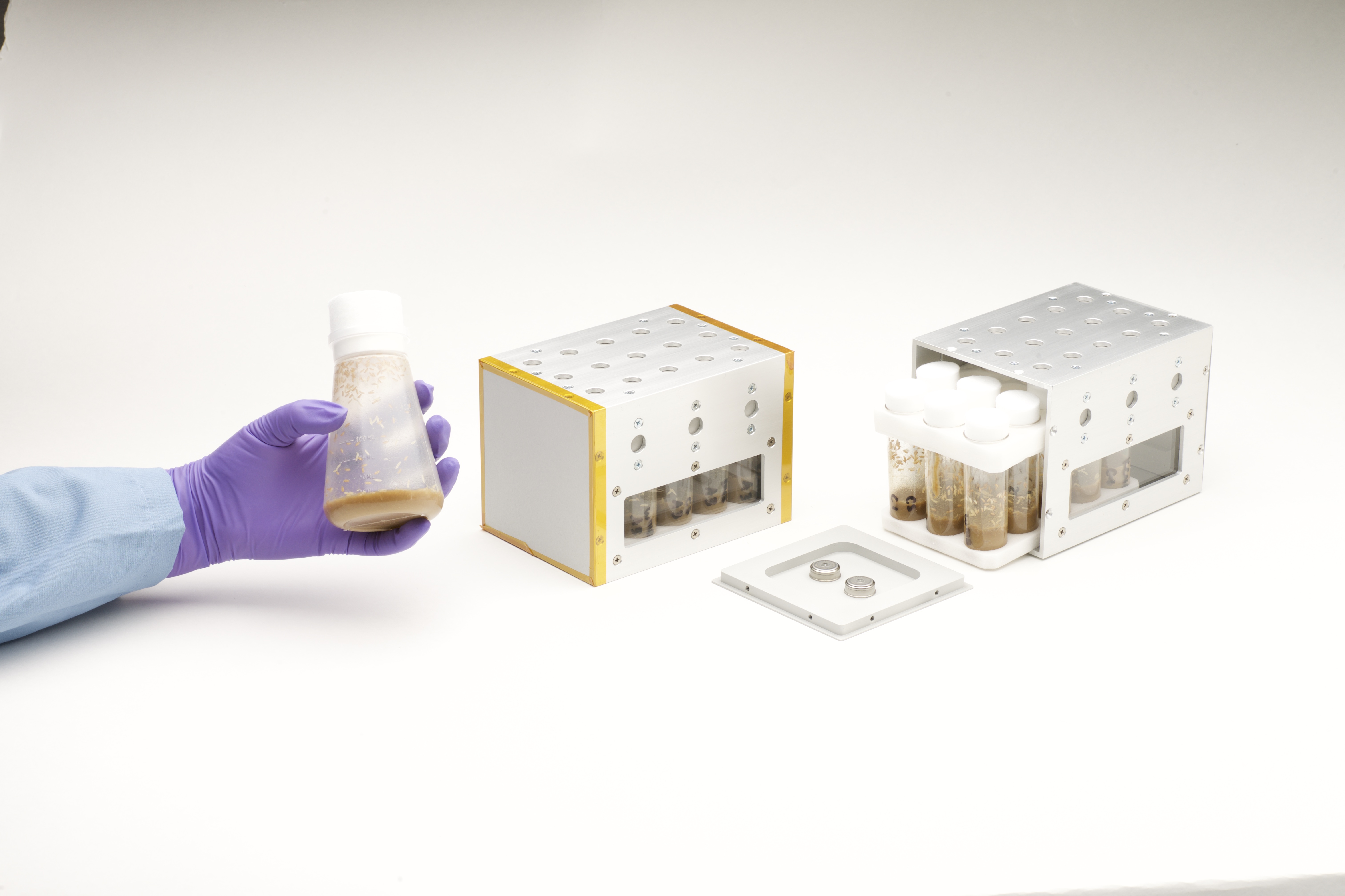
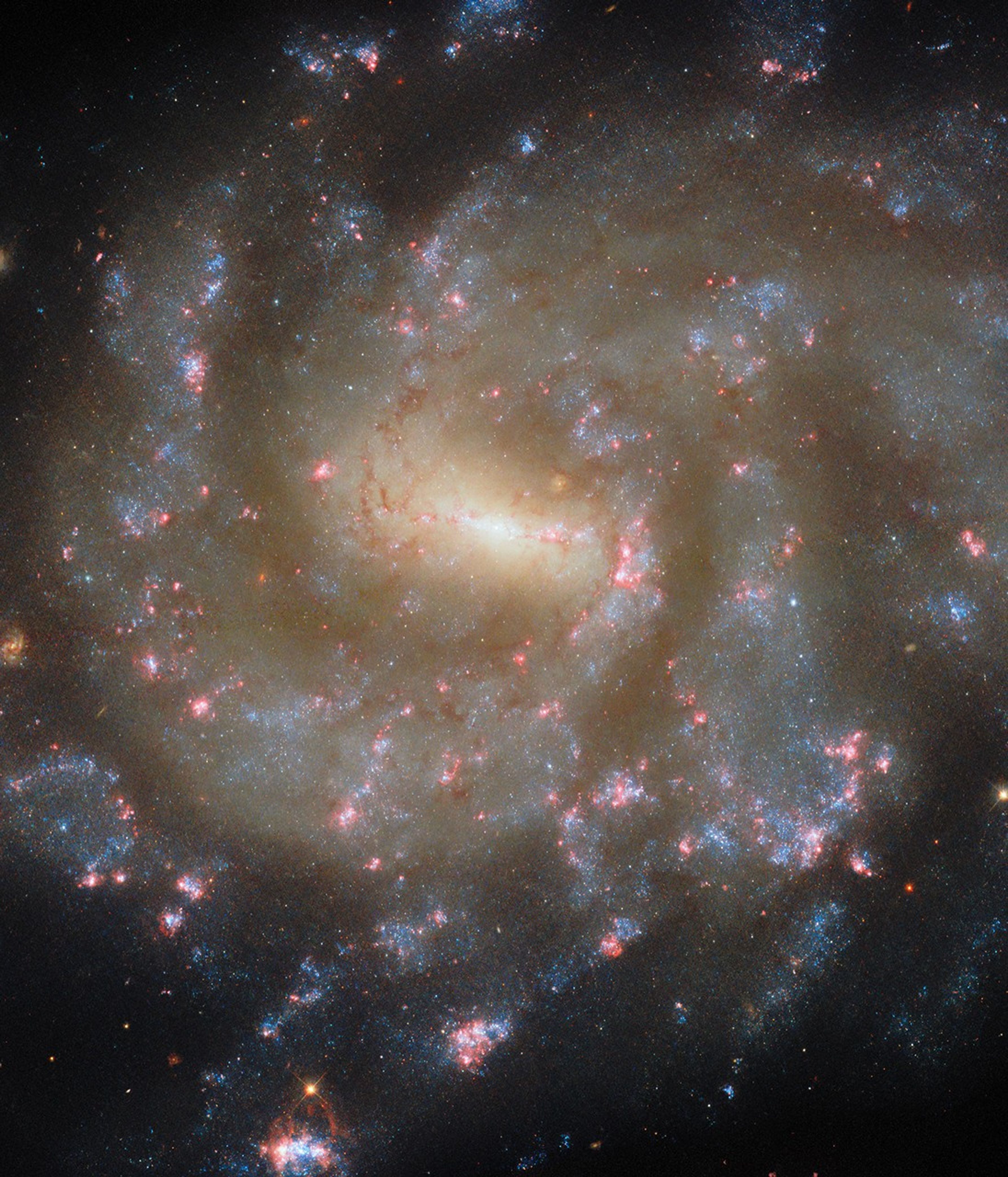
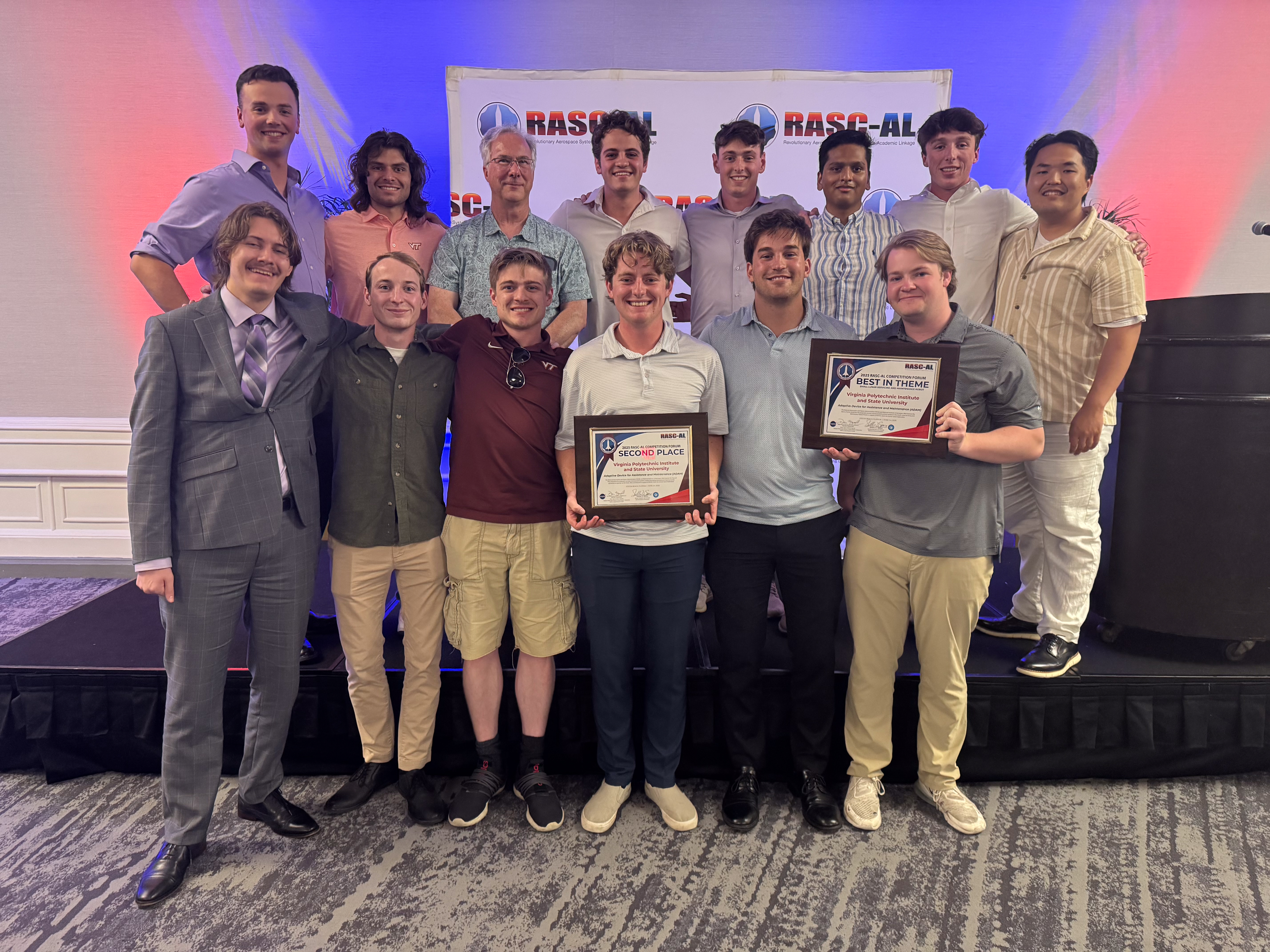
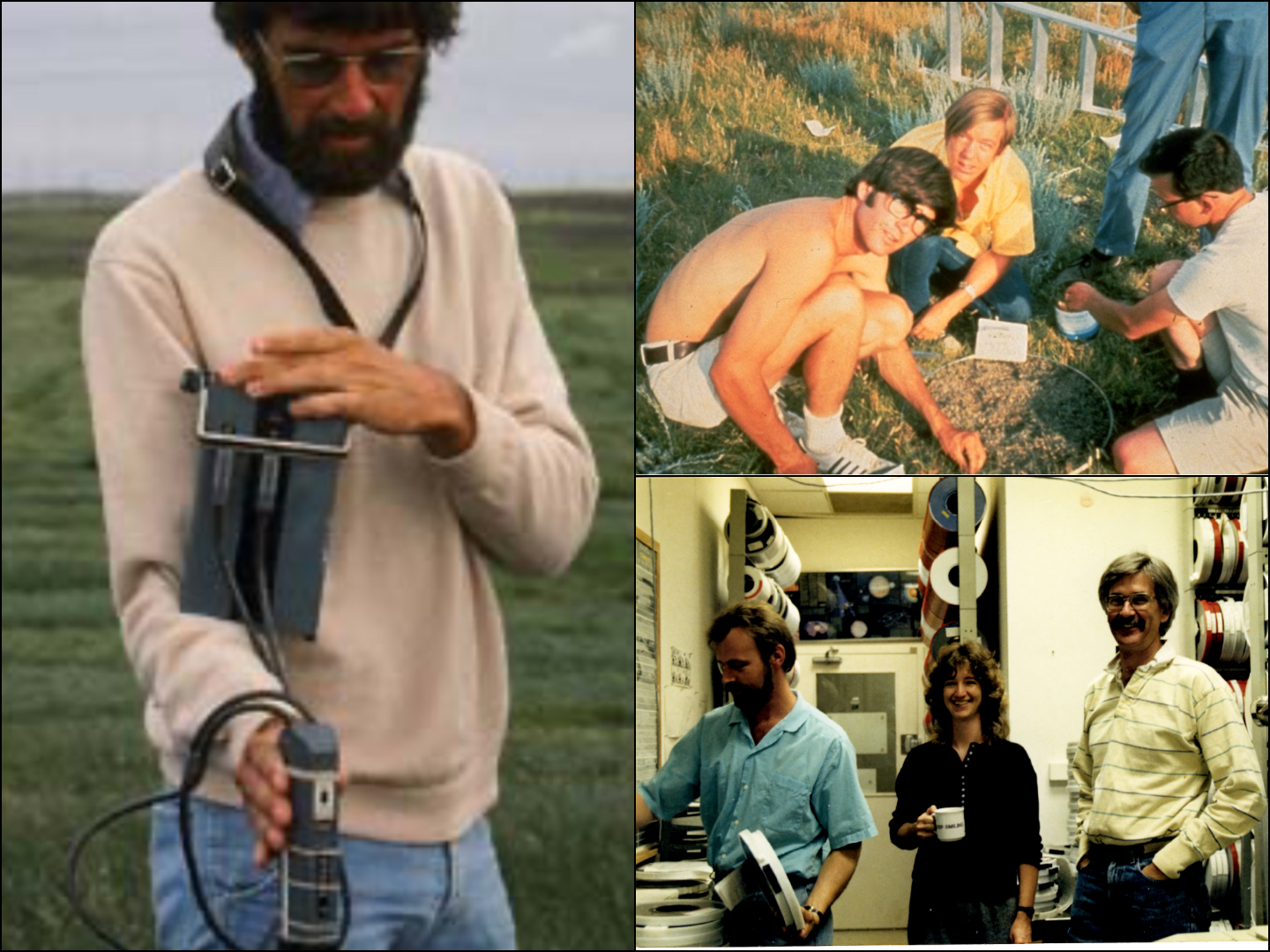
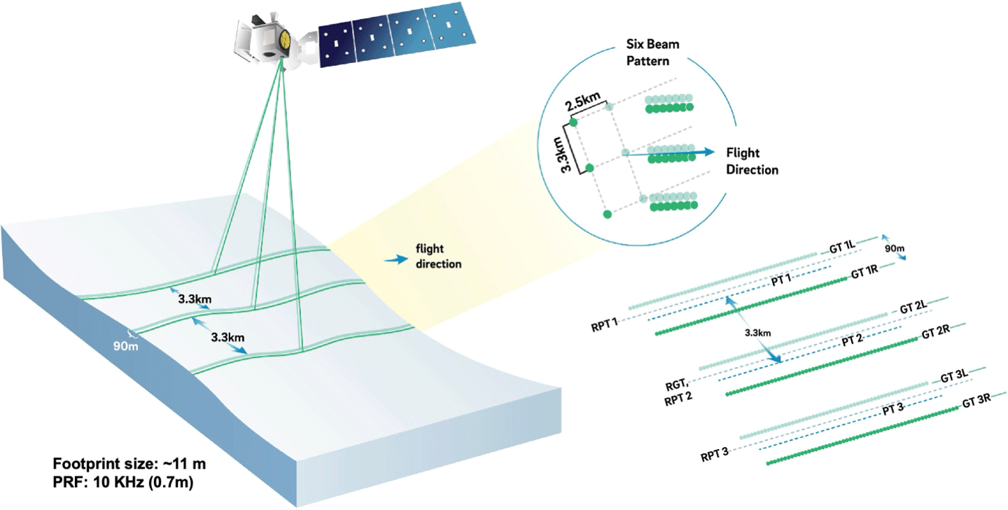
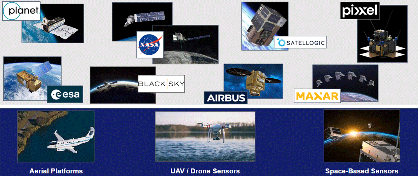
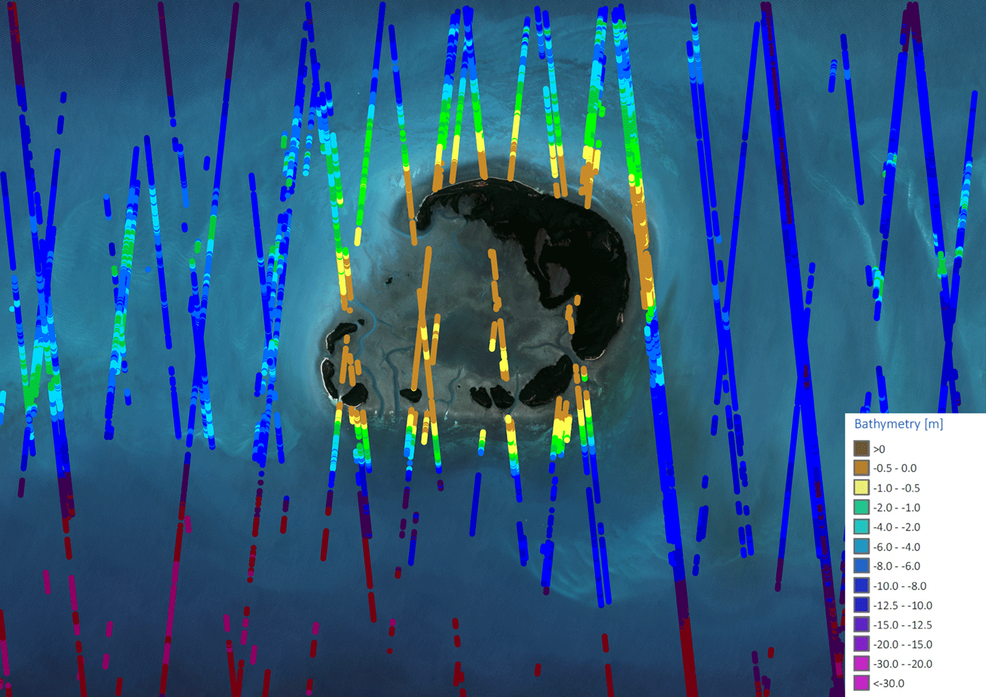
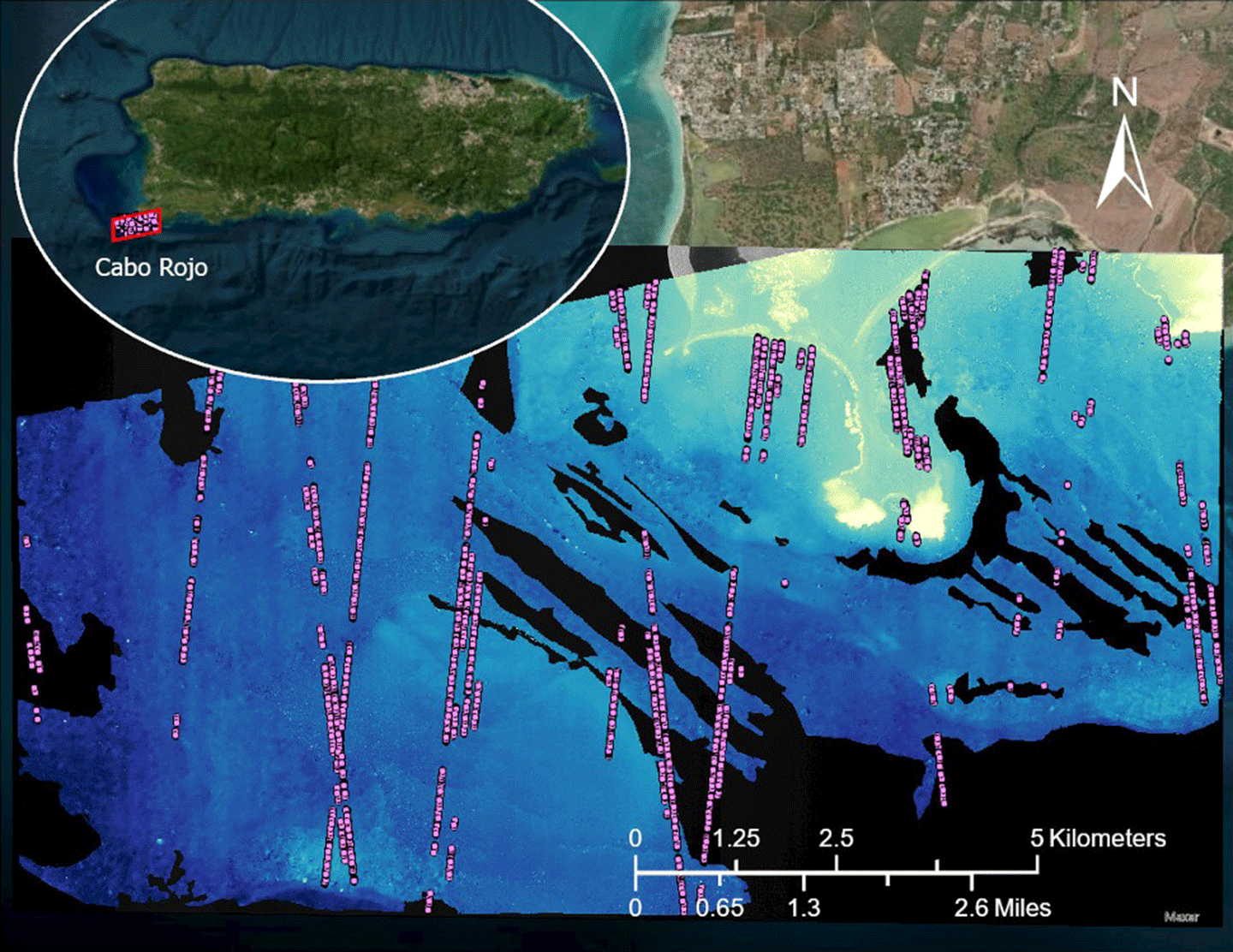
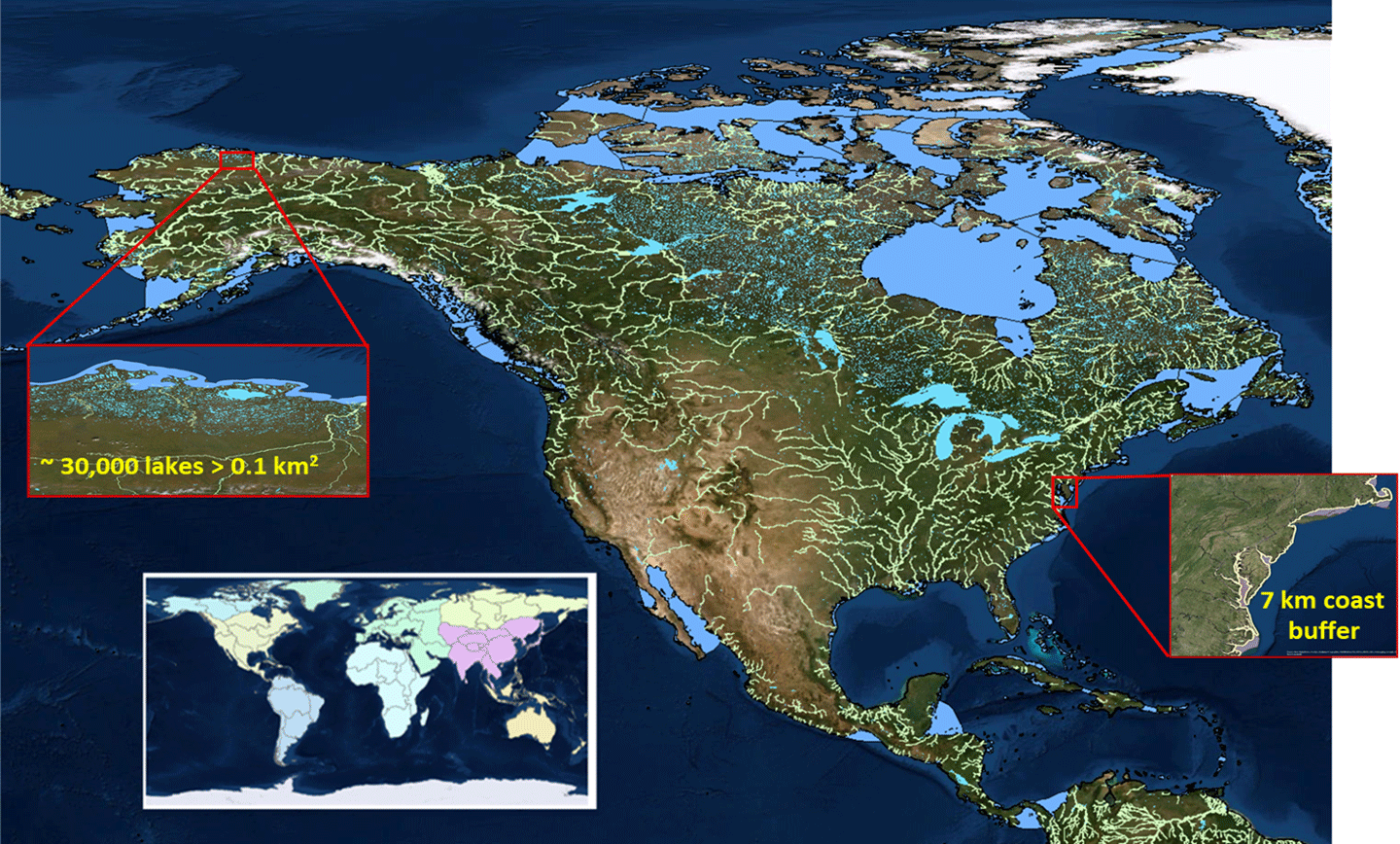
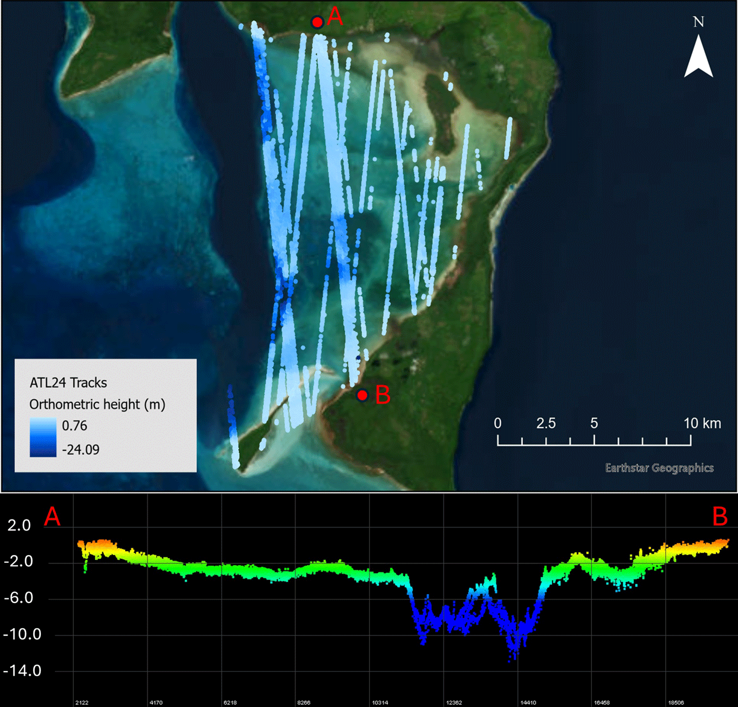
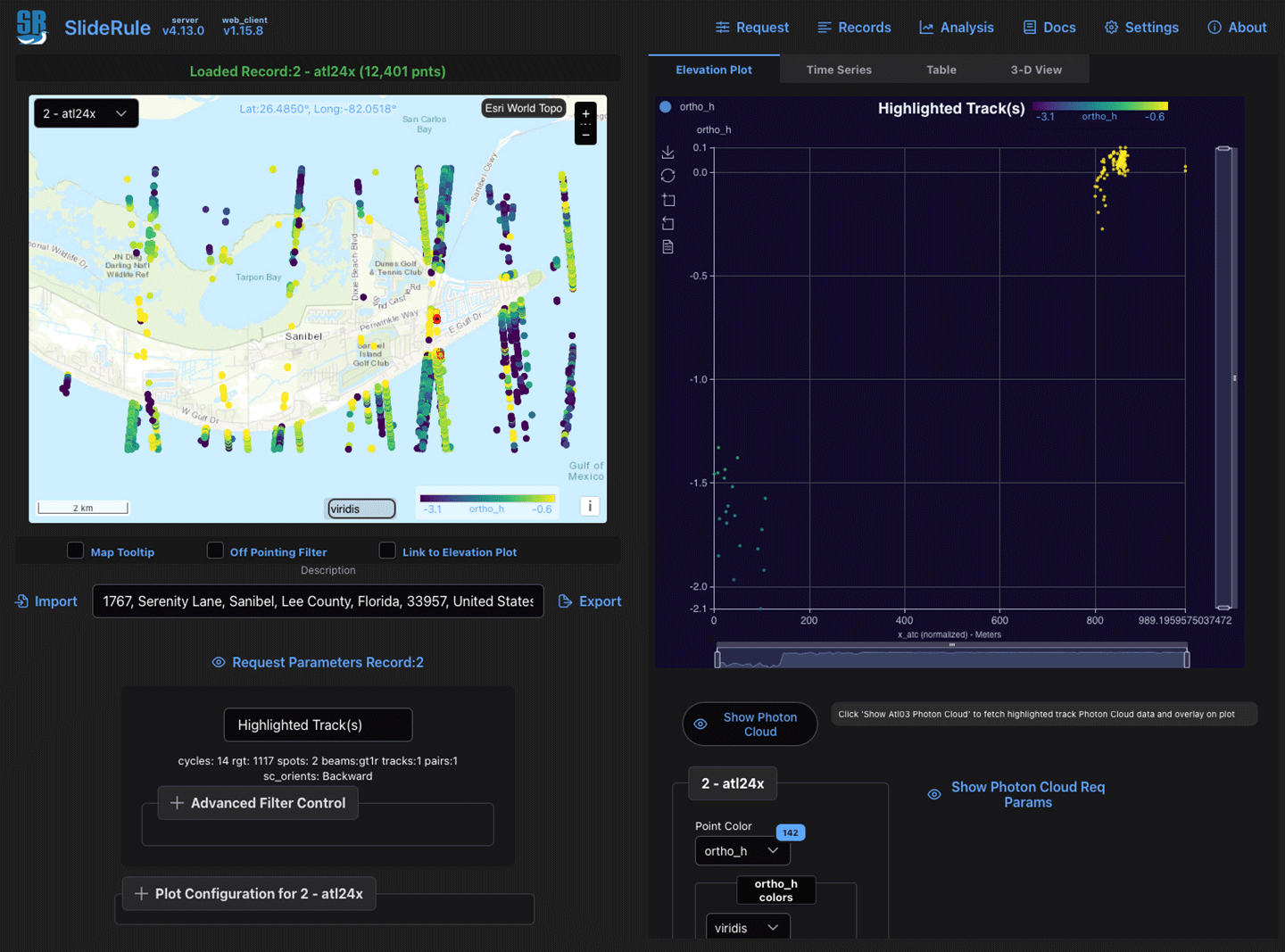
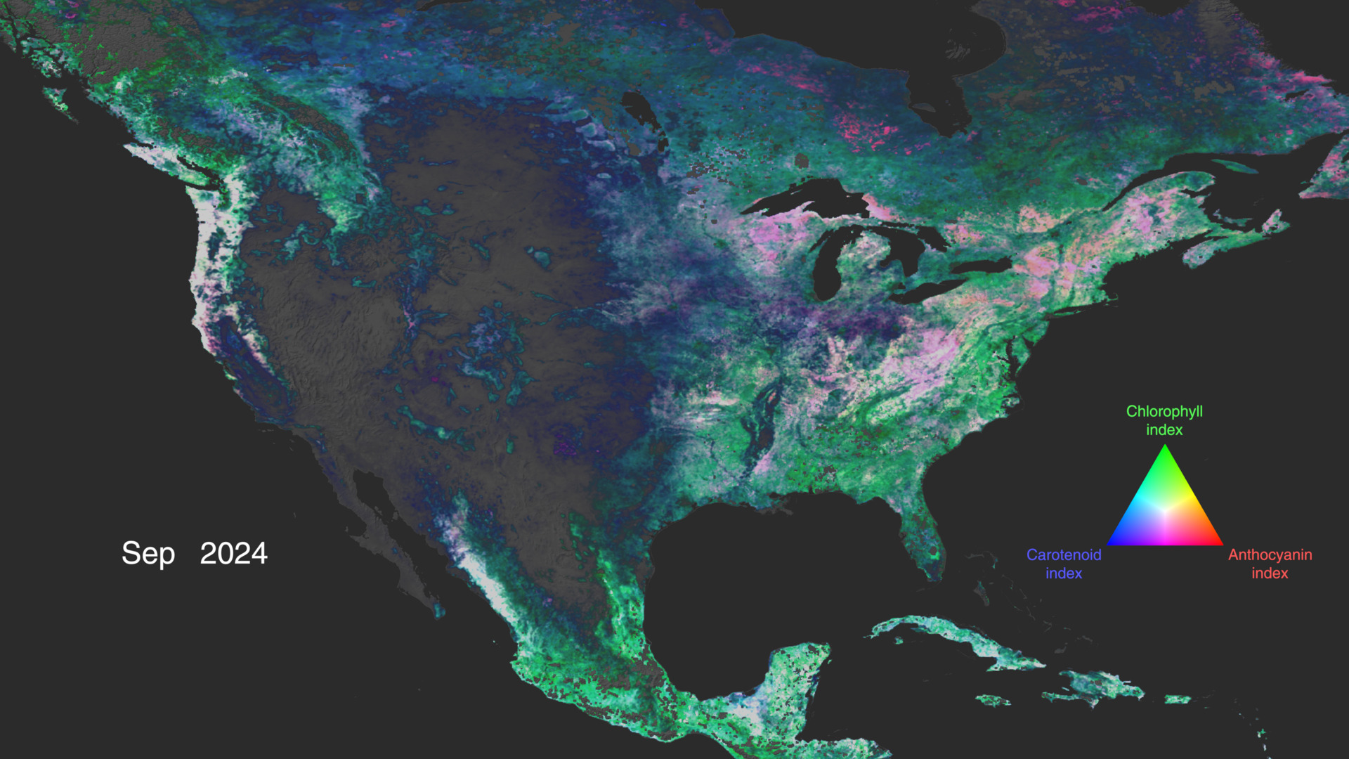