
NASA
General Law
As part of the legal functional management team, the General Law Practice Group provides leadership in the areas of ethics, fiscal law, environmental law, personnel and labor law, civil rights and equal employment law, information disclosure law, safety and security law, alien residence issues, memoranda of understanding and other agreements, and other administrative law matters in furtherance of NASA’s strategic goals.
The Practice Group provides staff to the Administrator by providing legal advice, representing the Administrator in litigation and administrative hearings, and performing special projects.
Finally, the Practice Group provides central services in the areas of legislation, litigation, adjudicating claims, and providing legal advice and review for Headquarters’ clients. In the area of legislation, we draft annual NASA authorization bills and other legislative proposals, review legislative proposals developed externally for legal sufficiency and agency-wide impacts, and review testimony and statements of Administration position for consistency with NASA policy and strategic goals. Staff of the Practice Group represents NASA in administrative and judicial litigation that arises from a Headquarters’ activity within our substantive areas of expertise. We also adjudicate claims arising from Headquarters’ activities. The Practice Group is responsible for managing NASA’s ethics program and at Headquarters we provide ethics training, review both public and confidential financial disclosure reports, and provide ethics counseling to employees.
ContactsAssociate General Counsel:
Katie Spear
Agency Counsel for Ethics:
Adam Greenstone
Paralegal Specialists:
Olivia Acosta
Victor Robinson
Attorney Staff:
Curtis Borland
Lawana Bryant
Bryan Diederich
Douglas Edgecomb
Griffin Farris
Shari Feinberg
Clevette Lee
Katie Spear
Gretchen Sosbee
Kathleen Teale
Dan Thomas
Headquarters OGC Organization
OGC Leadership Directory— Contact Information for the Headquarters Leadership and Center Chief Counsels
- How do I do this
OGC Disclaimer: The materials within this website do not constitute legal advice. For details read our disclaimer.
Summary of the 2023 Ocean Surface Topography Science Team Meeting
16 min read
Summary of the 2023 Ocean Surface Topography Science Team MeetingSeverine Fournier, NASA/Jet Propulsion Laboratory, severine.fournier@jpl.nasa.gov
Joshua Willis, NASA/Jet Propulsion Laboratory, joshua.k.willis@jpl.nasa.gov
Introduction
The annual Ocean Surface Topography (OST) Science Team Meeting (STM) provides a forum for the international altimetry community to foster collaboration, address specific issues, and highlight scientific results and applications every year. The meeting location alternates between Europe and the U.S. The 2023 meeting was held in San Juan, Puerto Rico, from November 7–11, 2023. About 130 registrants from more than a dozen different countries attended the meeting.
During this meeting the OST Science Team addressed specific technical issues related to the reference altimetry missions, which include the Ocean Topography Experiment (TOPEX)–Poseidon (1992–2006), Jason-1 (2001–2013), Ocean Surface Topography Mission (OSTM)/Jason-2 (2008–2019), Jason-3 (2016–present), and Sentinel-6 Michael Freilich (S6MF; 2020–present) missions. There was also discussion about the upcoming Sentinel-6B mission (scheduled for launch in 2025), which will be a successor to S6MF. The technical issues addressed included algorithm and model improvement, calibration/validation (cal/val) activities, merging TOPEX–Poseidon–Jason–S6MF data with those from other altimetric satellites, initial results from the Surface Water and Ocean Topography (SWOT) mission (2022–present), and preparation for future OST missions (e.g., Sentinel-6B).
The remainder of this article provides an overview of the meeting content, then presents an update on the status of current and planned OST missions, followed by a summary of the opening plenary and a couple of the most relevant science highlights from the splinter sessions. More details are available in the full report from the OST STM. The full OST STM program lists all of the presentations from the plenary, splinter, and poster sessions as well as links to many of the presentations and abstracts for the posters.
Meeting Overview
The meeting began with an opening plenary session, followed by an invited presentation, a series of splinter sessions, and a closing plenary session. The splinter session topics spanned a variety of algorithm improvements and measurement uncertainties, as well as sessions on coastal altimetry, the Chinese–French Oceanography Satellite (CFOSAT) mission (2019–present), and science topics ranging from climate and oceanography to hydrology and cryosphere science. A complete list of splinters is available online. Some of these are described in more detail in the sections that follow.
Status Report on Current OST Missions
This section reports on the status of several current and planned OST-related satellite missions. Each is described in its own subsection.
Sentinel-6 Michael Freilich
S6MF, launched on November 21, 2020, from Vandenberg Space Force Base, successfully completed its commissioning and subsequent entry into routine operations on schedule, one year later. S6MF succeeded Jason-3 as the Reference Mission (i.e., the mission that other altimetry missions are compared to) on April 7, 2022, at which point Jason-3 vacated the reference orbit. The first full mission reprocessing of products was released in July 2022, and another full reprocessing was completed in July 2023.
Jason-3
Jason-3, launched on January 17, 2016, continues its extended mission and is fully operational with all redundant systems available. It completed a longer than initially planned 15-month tandem phase with S6MF, which allowed for calibrations of both the primary and redundant instruments. On April 25, 2022, it began operations in an orbit that optimally interleaves ground tracks with S6MF. A second tandem phase with S6MF has been requested for early 2025. The second tandem phase aims to place an uncertainty bound on any long-term drift between the two missions.
Copernicus Copernicus Sentinel-3A and -3B
Sentinel-3A and -3B are identical satellites that were launched in February 16, 2016 and April 25, 2018, respectively. Similar to past missions in the reference orbit, a tandem phase with a separation of 30 seconds between the two satellites was performed to provide cross-calibration. Subsequently, Sentinel-3B was placed in a nominal orbit 140° out of phase with Sentinel-3A. Both missions now provide sea level measurements along high inclination tracks as part of their routine operations. A full mission reprocessing of land altimetry Level-2 (L2) products was completed in 2023.
Copernicus Sentinel-6B and 6C Missions and Beyond
Identical to S6MF, Sentinel-6B is planned as its successor. The spacecraft and instrument have been completed and is now in storage awaiting launch in 2025. Sentinel-6B will assure operational continuity through the end of 2030. An additional satellite, Sentinel-6C, is under consideration by NASA, the National Oceanic and Atmospheric Administration (NOAA), the European Organization for the Exploitation of Meteorological Satellites (EUMETSAT), the European Space Agency (ESA), and the Centre National d’Études Spatiale (CNES) [French Space Agency] to continue observations through 2035.
Surface Water Ocean Topography
SWOT launched on December 16, 2022. The primary instrument on SWOT, Ka-band radar interferometer (KaRIn), is the first space-borne, wide-swath altimetry instrument, capable of high-resolution measurements of the water height in the ocean and freshwater bodies. After commissioning and initial calibration, beta products became available to the science team in August 2023. The first images from SWOT were released, and the first results are showing great promise for the instrument capabilities (see NASA and CNES news).
Discussion of Future Missions Relevant to OST
The meeting continued with presentations on several existing and upcoming missions in various stages of development, each with applications relevant to OST. Each presentation included information on the mission’s status and development plans, as described below.
Copernicus Polar Ice and Snow Topography Altimeter (CRISTAL)
Copernicus Polar Ice and Snow Topography Altimeter (CRISTAL) is one of six, high-priority candidate Copernicus Sentinel Expansion missions that are being studied to address the European Union’s needs, as well as to extend the current capabilities of the Copernicus space components. CRISTAL will carry a multifrequency radar altimeter and microwave radiometer to ensure continuity and improve the quality of sea ice thickness measurements compared to its predecessor, Cryosat-2, and provide the first space-based measurements of overlying snow depth.
Recommendations from the OST Science Team
After discussing these missions and other issues concerning altimetry, the OST STM adopted several recommendations to particular topics relating to these missions, which are named and described in the subsections that follow:
S6MF Extended Operations Phase Orbit.
In light of that fact that user needs remain very high for altimetry observations complementary to the reference mission, the OST ST recommends extending operations of S6MF – assuming it remains in good health – beyond the time when Sentinel-6B has become the reference mission. Specifically, the OST ST recommends:
- Moving S6MF to an exact repeat orbit with the same characteristics as the reference orbit – except for a phase difference of 163° along the orbit, either ahead or behind Sentinel-6B – resulting in an interleaved ground-track to the reference orbit. (For reference, Jason-3 currently flies 163° behind S6MF.)
- Adopting the same data availability requirements as expressed in the End-User Requirements Document (EURD) (R-U- 00460/490/500/515/520/570/573/576) for the extended operations phase of S6MF, with the understanding that Sentinel-6B operations will be prioritized over S6MF.
Jason-3 Orbit Change.
The OST ST endorses the current plan to move Jason-3 to a Long Repeat Orbit (LRO) immediately after the conclusion of second tandem with S6MF. This 371-nodal-day LRO should be the same as the one occupied by Jason-2. The first two LRO cycles should be phased such that Jason-3 will interleave the two Jason-2 LRO cycles, each shifted by 2 km (1.2 mi). This will result in a systematic 2-km global grid combining Jason-2 and Jason-3 LRO data. The OST ST also recommends two additional LRO cycles that revisit the Jason-2 LRO ground tracks to fill in gaps and reduce mean sea surface errors.
Climate Quality Accuracy in Future Mission
To achieve accuracy in global and regional sea level change as detailed in the Global Climate Observing System (GCOS) requirements, the OST ST noted that it will be necessary to maintain and continue to improve the accuracy of orbital determination systems, such as those achieved using a combination of three tracking systems – Satellite Laser Ranging [SLR], Doppler Orbitography and Radiopositioning Integrated by Satellite (DORIS), and Global Navigation Satellite System [GNSS]). The OST ST has demonstrated that these tracking systems are necessary to achieve maximum accuracy on the determination of regional sea level trends and strongly recommends that such accuracy be maintained in the design of Sentinel-6C. The OST ST also noted that accuracy of the Climate Data Record requires continued maintenance or improvement of the terrestrial reference frame, which also relies on these tracking systems. Finally, requirements on other aspects of the altimetric measurement system must also be maintained or continue to improve.
Synergies with Argo and GRACE
Argo (which is an international fleet of robotic instruments that drift with the ocean currents and measure the temperature and salinity of the ocean) plays a critical role in collecting data related to numerous cross-cutting, climate-related science topics important to altimetry measurements (missions discussed earlier in this article), to gravity measurements [e.g., the Gravity Recovery and Climate Experiment (GRACE) and GRACE-Follow-On missions], and to broader science communities. The recent implementation of the Deep Argo mission has rapidly expanded observations of the ocean below 2000 m (~6500 ft). Data collected at these depths has helped to resolve questions about variations of temperature and salinity over the full depth of the ocean and to close regional and global sea level budgets. The OST ST recommends substantially increasing support for the OneArgo Program (which has been part of Argo’s design plan since 2020), including adding resources to expand the array to include global implementation of Deep Argo and increase coverage by Core Argo (the fleet of shallower floats) in polar regions and marginal seas.
Altimetry Product Evolution
OST ST recommends that agencies study the performance of the three latency products – Near Real-Time (NRT), Short Time-Critical (STC), and Non-Time Critical (NTC) – to ensure each continues to meet user needs or determine if their performance and latencies be redefined or adjusted. This should be considered across all platforms.
Potential Gap between CryoSat-2 and CRISTAL
The OST ST recommends studies to address which satellites, airborne operations, or other assets might help fulfill scientific needs for high-latitude ocean and ice elevation measurements during a potential gap between CryoSat-2 and CRISTAL. The OST ST also recommends minimizing the probability of a gap by extending CryoSat-2 operations through at least 2028 and avoiding delays in the launch of CRISTAL to the extent possible.
Integrity of the Altimetry Constellation and Instrument Function
In light of ongoing efforts to launch a large number of communications satellites in orbits close to the 1336 km (830 mi) altimetry constellation, the OST ST recommends that agencies take steps to determine and establish sufficient margins that will safeguard altimetry missions in both reference and polar orbits from collision, debris, and interference with their passive and active instruments.
Opening Plenary Session Highlights
Severine Fournier [NASA/Jet Propulsion Laboratory (JPL)] began with welcoming remarks on behalf of all of the project scientists, who (in addition to herself) include Josh Willis [NASA/JPL], Pascal Bonnefond [CNES], Eric Leuliette [NOAA], Remko Scharroo [EUMETSAT], and Alejandro Egido [ESA]. In particular, Fournier reminded the participants of the addition of online forums, available until the next OST STM that can be accessed after logging into the site. In addition, Fournier announced that Egido will replace Craig Donlon as the ESA Project Scientist.
Program managers gave presentations on the status of altimetry and oceanographic programs at their respective institutions including: Nadya Vinogradova-Shiffer [NASA Headquarters], Annick Sylvestre-Baron [CNES], Estelle Obligis [EUMETSAT], Eric Leuliette, and Jérôme Bouffard [ESA].
In addition, Josh Willis presented Space Stories, a think tank for U.S.-based creatives and technologists to develop new storytelling approaches to sea level rise. This initiative is organized by Garage Stories and consists of masterclasses that were held in November 2023 with 15 participants across 5 teams. The winning team will have the opportunity to present their concept at JPL in 2024.
Finally, Fernando E. Pabón [Caribbean Center for Rising Seas—Director] spoke about climate issues that impact Puerto Rico. The island has about three million inhabitants and faces several climatic issues, including devastating impacts from hurricanes (with a hurricane season stretching over six months every year), sea level rise, and droughts. While Puerto Rico has a lot of outdated infrastructures, the territory has the most advanced regulatory environment in the Caribbeans. Pabón explained the economic, social, and geographical urgency of making good decisions to help the communities facing climatic challenges with a long-term vision. One of the goals of the Caribbean Center for Rising Seas is to work with practitioners and the public to change urban development practices, update building codes, zoning, and land-use regulations and spread the knowledge and understanding of sea level rise and flooding to the public.
Science Highlights
This section provides two scientifically compelling results that were shown during the splinter sessions. Complete coverage of the results shared during these sessions can be found at the website at the start of the article.
Synergies between Argo, GRACE, and Altimetry
Human activities are increasing the concentration of greenhouse gases, which have increased global temperature since the beginning of the twentieth century. Greenhouse gases trap energy within the Earth system. The ocean absorbs much of this excess energy in the form of heat (> 90%), acting as a huge heat reservoir. Global ocean heat content (GOHC) is therefore a key component in the Earth’s energy budget. Accurate knowledge of the GOHC change allows us to assess the Earth Energy Imbalance (EEI), which refers to the difference between the amount of energy the Earth receives from the Sun and the amount of energy it radiates back into space.
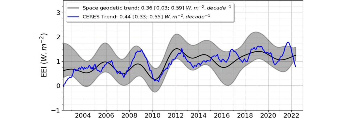
Various methodologies exist to estimate EEI from the GOHC. A 2022 article in Earth System Science Data describes the space geodetic approach, which relies on satellite altimetry and gravimetry measurements. Satellite altimetry is used to measure sea level rise, which is caused by both the expansion of warming ocean waters and the addition of freshwater to the ocean from melting land ice (Greenland and Antarctic ice sheets and mountain glaciers). Gravimetric measurements are used to measure ocean mass change, which can be used to estimate the contribution to sea level rise from freshwater ice melt on land. By combining gravimetry and altimetry, it is possible to estimate the thermal expansion of the entire ocean and scale it to estimate EEI – see Figure 1. The magnitude of EEI is small (0.5–1.0 W/m2) compared to the total amount of energy entering and leaving the climate system (~340 W/m2). Therefore, a high level of precision and accuracy are required to estimate the EEI mean (< 0.3 W/m2) and its time variations at decadal scales (< 0.1 W/m2). In this regard, the space geodetic approach emerges as a promising candidate capable of complementing other observing system elements aimed at measuring EEI.
Figure 1. This graph shows the decadal variations of the Earth Energy Imbalance (EEI) estimated from the space geodetic method that combines altimetry and gravimetric measurements (black) and direct measurements of solar radiation at the top of the atmosphere from the Clouds and the Earth’s Radiant Energy System (CERES) instrument (blue). The grey shaded area corresponds to the space geodetic method’s uncertainty. Image credit: Michael Ablain/Collect Localisation Services (CLS), FranceLarge-scale Ocean Circulation Variability and Change
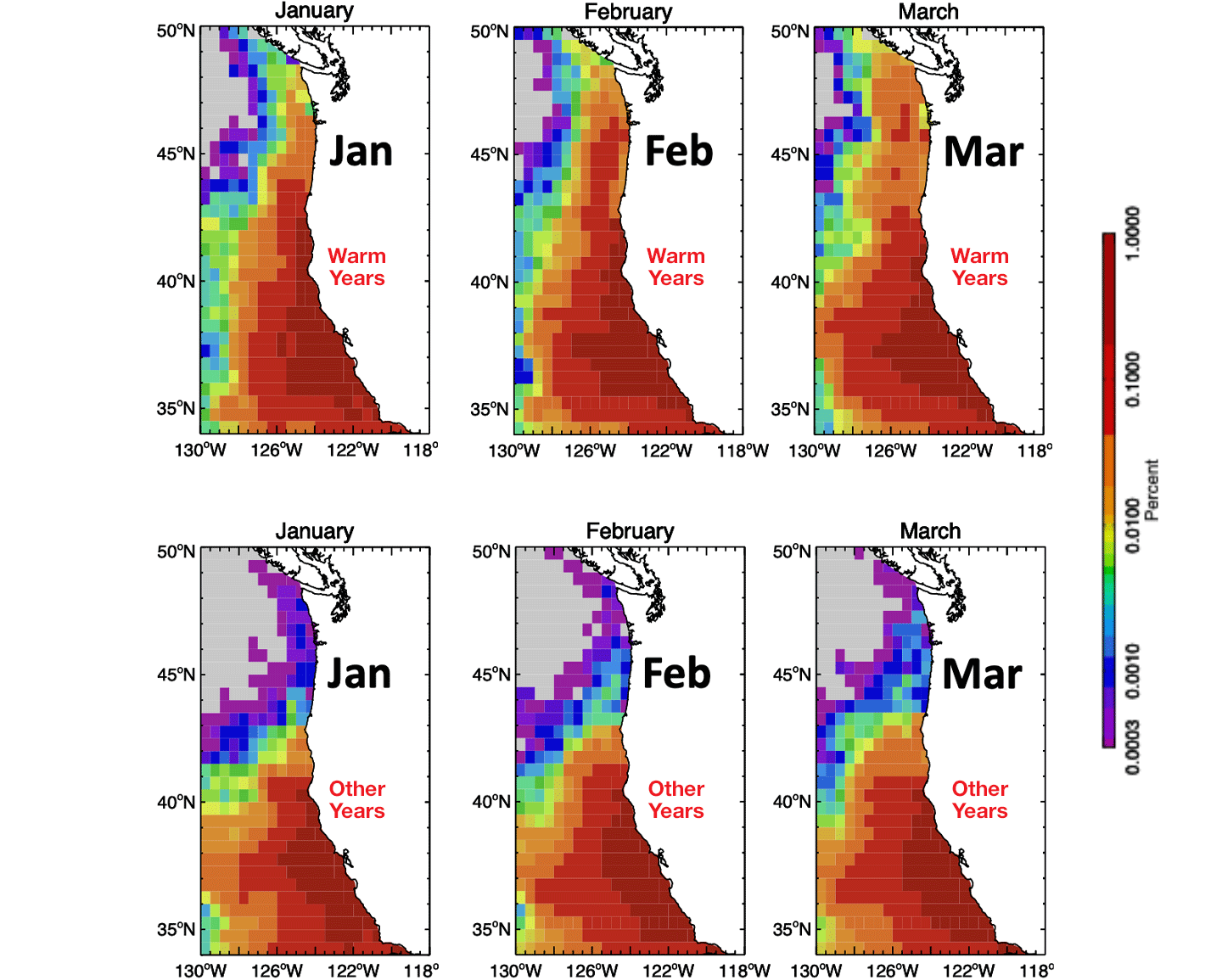
The year-to-year circulation changes along the coast of the western U.S. can have significant impact on the transport of nutrients that affect fisheries. A 2021 article published in the journal Limnology and Oceanography described a study that used ocean currents derived from satellite altimetry to understand the trajectory of water masses from the southern coast of California to the Pacific Northwest. The results show that after a year, subtropical/tropical water masses can reach the Oregon coast from the Southern California Bight (30 °N), and in multiple years from even further south (~26 °N–27 °N) and west. During warmer than average years associated with El Niño Southern Oscillation (1997–1998, 2002–2003, 2004–2005, 2005–2006, 2009–2010, 2014–2015, 2015–2016, 2016–2017), these subtropical/tropical waters masses reached further north compared to other years – see Figure 2. This shift is due to the increase poleward wind stress observed in the California Current. The research team also showed that these tropical warm waters tend to transport “warm water” zooplankton species with a lower fat content. The shift in zooplankton species can impact the young salmon population, which prefer fatty cold-water zooplankton, entering the ocean off the Oregon coast.
Figure 2. This graph shows the density of the water mass traveling northward from the tropics and sub-tropics toward the Pacific Northwest coast during [first three panels] the average of Warm Years (1997–1998, 2002–2003, 2004–2005, 2005–2006, 2009–2010, 2014–2015, 2015–2016, 2016–2017) for January, February, and March, and [last three panels] normal, or Other Years (remaining 15 years excluded from the ‘warm year episodes’ between 1997–2020) for January, February, and March. Off the coast of Oregon, warm water masses are denser during warm years. Image credit: Ted Strub/Oregon State UniversityClosing Plenary Session Highlights
The closing plenary session included discussions, notably about the key points that were addressed during the opening session and splinter sessions.
Cristina Martin-Puig [EUMETSAT] gave a presentation on the definition of the new Geophysical Data Record (GDR) standards (GDR-G) in a multimission context. There are currently 11 altimeters operating with data quality that continues to undergo improvement. While agencies have been coordinating to homogenize processing baselines across missions, a full harmonization between missions was never discussed in detail until now. All agencies are now working in full collaboration to define a set of common standards and the best data processing practices to ensure full harmony between missions.
Conclusion
During the closing session, the OST ST adopted several recommendations – see “Recommendations from the OST Science Team” above for details.
The OST STM expressed strong support for the continuation of the joint Indo–French Satellite AltiKa (SARAL) drifting period for as long as possible, with its altimeter being the most important for future improvements in mean sea surface and gravity.
The OST STM ended with acknowledgements and kudos, several of which refer to recommendations made by the OST ST. The team expressed its appreciation to NASA and CNES for the successful launch and commissioning of the SWOT mission and its revolutionary new wide-swath altimeter for ocean and surface water. Additional acknowledgements can be found in the full OST STM report link referenced in the introduction of this article.
Overall, the meeting fulfilled all of its objectives. It provided a forum for updates on the status of Jason-3, S6MF, and other relevant missions and programs. It also offered detailed analyses of mission observations by the splinter groups. The team concluded that data from the Jason-3 and S6MF altimeters continue to meet the accuracy and availability requirements of the science community.
An international altimetry meeting to celebrate the 30-year anniversary of altimetry will be held in Montpellier, France on September 2–7, 2024.
Acknowledgment: This article is based on the official meeting report, referenced in the introduction of this article and prepared in cooperation with all of the OST STM chairs: Severine Fournier [JPL]; Josh Willis [JPL]; Pascal Bonnefond [Observatoire de Paris, Laboratoire Systèmes de Référence Temps-Espace (SYRTE)/CNES]; Eric Leuliette [NOAA]; Remko Scharroo [EUMETSAT]; and Alejandro Egido [ESA].
Share Details Last Updated May 31, 2024 Related TermsEvery Day is Earth Day for OSI’s Environmental Program
To view this video please enable JavaScript, and consider upgrading to a web browser that supports HTML5 video
In OSI’s Environmental Management Division, we believe every day is Earth Day as we enable environmentally sound mission success through leadership of NASA efforts to comply with environmental laws and advance stewardship and sustainability. See more about what we do for the environment in the Office of Strategic Infrastructure’s (OSI) Earth Day video and nasa.gov/emd where we showcase our programs. Thank you for all you do for protecting our environment.
Headquarters and Center Chief Counsel Contacts
General Counsel
Iris Lan
Deputy General Counsel
Christine Pham (Acting)
Director of Legal Operations
Bryan R. Diederich (Acting)
Associate General Counsel for Commercial and Intellectual Property Law Practice Group, Headquarters
Karen Reilley
Associate General Counsel for Contracts and Acquisition Integrity Law Practice Group, Headquarters
Scott Barber
Associate General Counsel for General Law Practice Group, Headquarters
Katie Spear
Associate General Counsel for International and Space Law Practice Group, Headquarters
Rebecca Bresnik
Agency Counsel for Ethics, Headquarters
Adam F. Greenstone
Director of the NASA Acquisition Integrity Program (Fraud Remedies) and the Agency Counsel for Acquisition Integrity, Headquarters
Monica Aquino-Thieman
Agency Counsel for Intellectual Property, Headquarters
Trenton Roche
Chief Counsel, Ames Research Center
Dan Hymer (Acting)
Chief Counsel, Armstrong Flight Research Center
Brett Swanson
Chief Counsel, Glenn Research Center
Callista M. Puchmeyer
Chief Counsel, Goddard Space Flight Center
Dave G. Barrett
Chief Counsel, Johnson Space Center
Randall T. Suratt (Acting)
Chief Counsel, Kennedy Space Center
Alex Vinson
Chief Counsel, Langley Research Center
Andrea Z. Warmbier
Chief Counsel, Marshall Space Flight Center
Pam A. Bourque
Chief Counsel, NASA Management Office at JPL
James T. Mahoney
Chief Counsel, NASA Shared Service Center
Ron Bald
Chief Counsel, Stennis Space Center
Ron Bald
General Counsel Organization – Headquarters
General Counsel
Iris Lan
Deputy General Counsel
Christine Pham (Acting)
Director of Legal Operations
Bryan R. Diederich (Acting)
Associate General Counsel for Contracts and Acquisition Integrity Law Practice Group
Scott Barber
Associate General Counsel for General Law Practice Group
Katie Spear
Associate General Counsel for Commercial and Intellectual Property Law Group
Karen M. Reilley
Associate General Counsel for International and Space Law Practice Group
Rebecca Bresnik
Agency Counsel for Ethics
Adam F. Greenstone
Director, Acquisition Integrity Program
Monica Aquino-Thieman
Parachute Engineer Anh Nguyen
“[My proudest moment] was deciding post-college what to do [in my life] and not asking for advice anymore. It’s one of those things where I love asking for advice but sometimes almost too much where I feel like it over influences what I want to do. And in my career, it was the same way. People would keep telling me, ‘Oh, you’re really good at this. You should probably go into this position, or you should try this.’ Now, I sit in certain moments and decide, is this a position I want to take and pursue, or do I really want to do [something else] instead? And then, if I fail or succeed, at least it was my choice.
“So, that moment, that first time [post-college], I realized I had built enough confidence to pursue and do things I wanted to do, whether or not it was something that other people could see me succeed at. I am the type of person where I can succeed at a lot of things because I work hard. I’ll put in my effort, but if I don’t have that interest in it or if it doesn’t align with my current values, I’m not going to get very far in it, and I’m going to be miserable, so I don’t know why I kept trying to entertain that idea.
“These days, I can still take advice from people but not let it totally dictate or control the path that I want to go down or the decisions I want to make because it’s my choice. Much of my path stemmed from my confidence in making the decision, filtering out the judgment of certain people, and realizing that someone might think differently about me this way, but does that really matter?”
– Anh Nguyen, Parachute Engineer, Commercial Crew Program, NASA’s Kennedy Space Center
Image Credit: NASA/Glenn Benson
Interviewer: NASA/Tahira Allen
NASA’s Europa Clipper Unpacks in Florida
Crews rotated to vertical then lifted NASA’s Europa Clipper spacecraft from its protective shipping container after it arrived at the Payload Hazardous Servicing Facility (PHSF) at the agency’s Kennedy Space Center in Florida on May 28.
The spacecraft, which will collect data to help scientists determine if Jupiter’s icy moon Europa could support life, arrived in a United States Air Force C-17 Globemaster III cargo plane at Kennedy’s Launch and Landing Facility on May 23. The hardware traveled more than 2,500 miles from NASA’s Jet Propulsion Lab in Southern California where it was assembled. The team transported Europa Clipper to the PHSF and will perform a number of activities to prepare it for launch, including attaching the high gain antenna, affixing solar arrays to power the spacecraft, and loading propellants that will help guide the spacecraft to its destination.
On board are nine science instruments to gather detailed measurements while Europa Clipper performs approximately 50 close flybys of the Jovian moon. Research suggests an ocean twice the volume of all the Earth’s oceans exists under Europa’s icy crust.
The Europa Clipper spacecraft will launch on a SpaceX Falcon Heavy rocket from NASA Kennedy’s Launch Complex 39A. The launch period opens Thursday, Oct. 10.
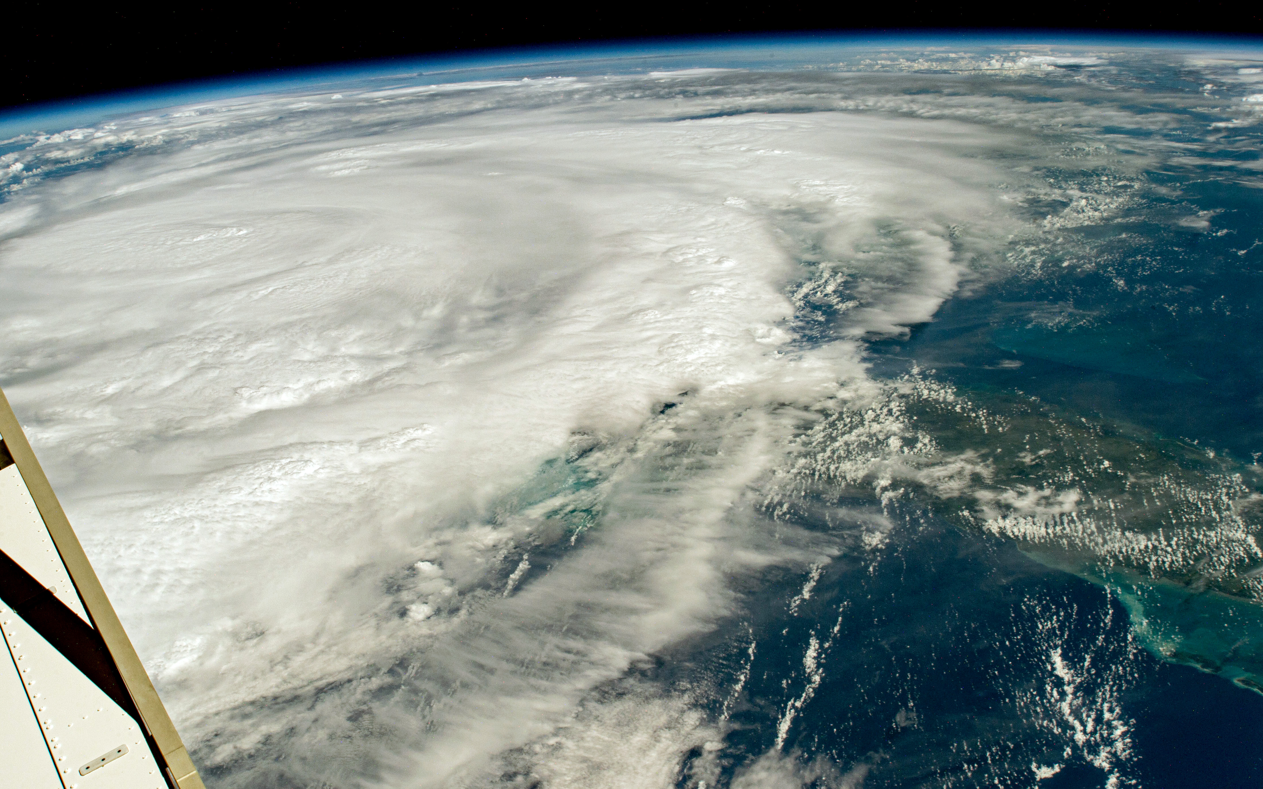
Hurricane Season Begins
Hurricane Season Begins
June 1 marks the beginning of the 2024 hurricane season in the Atlantic Ocean. NASA observes and studies hurricanes from space, both with views from the space station and with satellites. This vantage point helps scientists understand how climate change impacts hurricanes and learn how communities can better prepare for tropical cyclones in a warmer world.
On Aug. 29, 2023, one of the International Space Station’s external high-definition cameras captured Hurricane Idalia in the Gulf of Mexico. Idalia was a category 1 storm over the Gulf of Mexico with sustained winds of 140 kilometers (85 miles) per hour. As the storm moved north over the Gulf, it quickly strengthened and made landfall over the Big Bend region of Florida on the morning of August 30, 2023, as a category 3 storm.
Image Credit: NASA
Winners Named in NASA Space Tech Art Challenge
2 min read
Preparations for Next Moonwalk Simulations Underway (and Underwater) An illustration created by Luis Rivera Hernandez depicting his interpretation of the Mars Aerial and Ground Global Intelligent Explorer (MAGGIE), a novel aerospace concept study led by Ge-Cheng Zha with Coflow Jet, LLCSpace technology might look a bit different decades from now. The NASA Innovative Advanced Concepts (NIAC) program studies innovative, technically credible, advanced projects that could one day “change the possible” in aerospace. To help people understand what these innovations might look like, NIAC has turned to artists and graphic designers in a global contest to create posters to visualize future technologies under development.
The NASA Space Tech Art Challenge: Imagine Tomorrow received 480 entries from 39 countries. Nine submissions were awarded an even share of the $3,000 prize. The winning submissions from the following individuals depict what the technology might look like, and how and where the concepts might be used in future exploration.
- Rizky Irawan, Indonesia
- Luis Rivera, USA
- Yi Cai, USA
- Holly Pascal, USA
- Beatriz Bronoski, Brazil
- Matthew Turner, United Kingdom
- Joseph Henney, USA
- Bertrand Dano, USA
- Hadley Nicole D., USA
The NASA Tournament Lab – part of the Prizes, Challenges, and Crowdsourcing program within the agency’s Space Technology Mission Directorate – managed the challenge. The NASA Tournament Lab facilitates crowdsourcing to tackle agency science and technology challenges, engaging the global community to seek new ideas and approaches that will ultimately benefit all of humanity. Freelancer.com administered the challenge for NASA.
To learn more about NASA prizes and challenges opportunities, visit:
Facebook logo @NASATechnology @NASA_Technology Keep Exploring Discover More Topics From NASASpace Technology Mission Directorate
NASA Innovative Advanced Concepts
Get Involved
NASA Prizes, Challenges, and Crowdsourcing
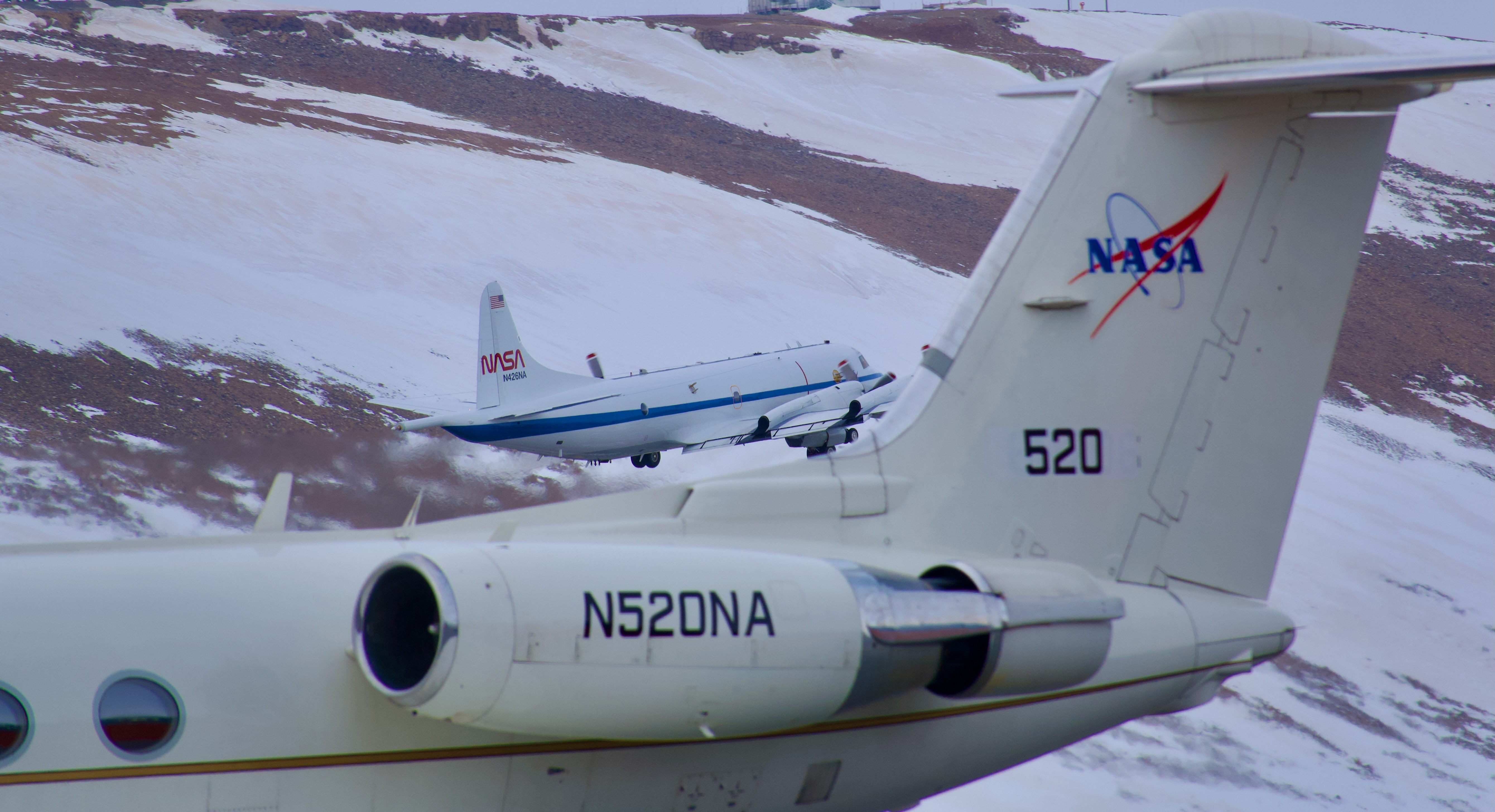
Share Details Last Updated May 31, 2024 EditorLoura Hall Related TermsNASA Mission Flies Over Arctic to Study Sea Ice Melt Causes
4 min read
Preparations for Next Moonwalk Simulations Underway (and Underwater)It’s not just rising air and water temperatures influencing the decades-long decline of Arctic sea ice. Clouds, aerosols, even the bumps and dips on the ice itself can play a role. To explore how these factors interact and impact sea ice melting, NASA is flying two aircraft equipped with scientific instruments over the Arctic Ocean north of Greenland this summer. The first flights of the field campaign, called ARCSIX (Arctic Radiation Cloud Aerosol Surface Interaction Experiment), successfully began taking measurements on May 28.
Two NASA aircraft are taking coordinated measurements of clouds, aerosols and sea ice in the Arctic this summer as part of the ARCSIX field campaign. In this image from Thursday, May 30, NASA’s P-3 aircraft takes off from Pituffik Space Base in northwest Greenland behind the agency’s Gulfstream III aircraft.Credit: NASA/Dan Chirica“The ARCSIX mission aims to measure the evolution of the sea ice pack over the course of an entire summer,” said Patrick Taylor, deputy science lead with the campaign from NASA’s Langley Research Center in Hampton, Virginia. “There are many different factors that influence the sea ice. We’re measuring them to determine which were most important to melting ice this summer.”
On a completely clear day over smooth sea ice, most sunlight would reflect back into the atmosphere, which is one way that sea ice cools the planet. But when the ice has ridges or darker melt ponds — or is dotted with pollutants — it can change the equation, increasing the amount of ice melt. In the atmosphere, cloudy conditions and drifting aerosols also impact the rate of melt.
“An important goal of ARCSIX is to better understand the surface radiation budget — the energy interacting with the ice and the atmosphere,” said Rachel Tilling, a campaign scientist from NASA’s Goddard Space Flight Center in Greenbelt, Maryland.
About 75 scientists, instrument operators, and flight crew are participating in ARCSIX’s two segments based out of Pituffik Space Base in northwest Greenland. The first three-week deployment, in May and June of this year, is timed to document the start of the ice melt season. The second deployment will occur in July and August to monitor late summer conditions and the start of the freeze-up period.
“Scientists from three key disciplines came together for ARCSIX: sea ice surface researchers, aerosol researchers, and cloud researchers,” Tilling said. “Each of us has been working to understand the radiation budget in our specific area, but we’ve brought all three areas together for this campaign.”
Two aircraft will fly over the Arctic during each deployment. NASA’s P-3 Orion aircraft from the agency’s Wallops Flight Facility in Virginia, will fly below the clouds at times to document the surface properties of the ice and the amount of energy radiating off it. The team will also fly the aircraft through the clouds to sample aerosol particles, cloud optical properties, chemistry, and other atmospheric components.
A Gulfstream III aircraft, managed by NASA Langley, will fly higher in the atmosphere to observe properties of the tops of the clouds, take profiles of the atmosphere above the ice, and add a perspective similar to that of orbiting satellites.
The teams will also compare airborne data with satellite data. Satellite instruments like the Multi-angle Imaging Spectroradiometer and the Moderate Resolution Imaging Spectroradiometer will provide additional information about clouds and aerosol particles, while the Ice, Cloud, and land Elevation Satellite 2 will provide insights into the ice topography below both satellites and aircraft.
The aircraft will fly coordinated routes to take measurements of the atmosphere above ice in three-dimensional space, said Sebastian Schmidt, the mission’s science lead with the University of Colorado Boulder.
“The area off the northern coast of Greenland can be considered the last bastion of multi-year sea ice, as the Arctic transitions to a seasonally ice-free ocean,” Schmidt said. “By observing here, we will gain insight into cloud-aerosol-sea ice-interaction processes of the ‘old’ and ‘new’ Arctic — all while improving satellite-based remote sensing by comparing what we’re seeing with the airborne and satellite instruments.”
NASA’s Goddard Space Flight Center, Greenbelt, Md.
Share Details Last Updated May 31, 2024 EditorKate D. RamsayerContactKate D. Ramsayerkate.d.ramsayer@nasa.govLocationGoddard Space Flight Center Related Terms Explore More 5 min read Antarctic Sea Ice Near Historic Lows; Arctic Ice Continues Decline Article 2 months ago 5 min read Arctic Sea Ice 6th Lowest on Record; Antarctic Sees Record Low GrowthArctic sea ice likely reached its annual minimum extent on September 19, 2023, making it…
Article 8 months ago 4 min read NASA Ice Scientists Take Flight from Greenland to Study Melting Arctic Ice Article 2 years agoSpace Station Research Advances NASA’s Plans to Explore the Moon, Mars
Space, the saying goes, is hard. And the farther humans go, the harder it can get.
Some of the challenges on missions to explore the Moon and Mars include preventing microbial contamination of these destinations, navigating there safely, protecting crew members and hardware from radiation, and maintaining and repairing equipment.
Research on the International Space Station is helping NASA scientists develop tools and processes to ensure success on these important missions. Here are highlights from some of the investigations making space a little easier.
Tracking Tiny StowawaysBacteria and fungi live in and on all humans and all around us on Earth. Most of these microorganisms are beneficial or harmless but introducing them to other celestial bodies could adversely affect our ability to study ecosystems on those other worlds.
Crew members will conduct a spacewalk to collect samples near space station life support system vents for ISS External Microorganisms, an investigation to assess whether the orbiting laboratory releases microorganisms into space. Results could provide insight into the potential for organisms to survive and reproduce in space and help researchers determine which microbes would most likely contaminate other planetary bodies visited by crewed missions.
NASA astronaut Victor Glover trains for the ISS External Microorganisms spacewalk in the Neutral Buoyancy Laboratory pool at NASA’s Johnson Space Center in Houston.NASAA miniature, hand-held digital microscope designed to make in-flight medical diagnoses, the Moon Microscope, also can test water, food, and surfaces for contamination. The device images samples at high resolution and processes data on web-enabled devices such as phones or tablets. Multiple users can access the microscope simultaneously, and some applications run autonomously.
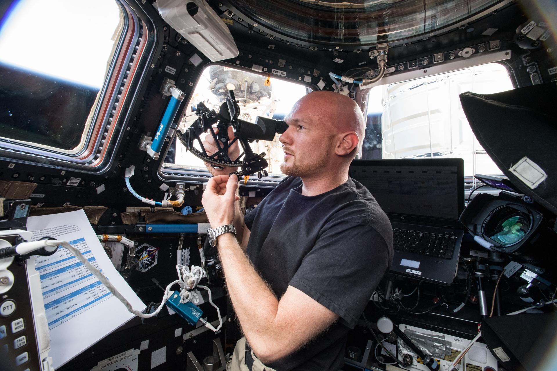
Getting There and BackSpacecraft must have sophisticated high-tech systems for navigating. Sextant Navigation tests the function of sextants in microgravity as an emergency backup navigation technique for Artemis and other future exploration missions. These mechanical devices have guided navigators for centuries, and Gemini and Apollo missions demonstrated they were useful for astronauts.
Astronaut Alexander Gerst of ESA (European Space Agency) tests the Sextant Navigation device.NASA Refining Radiation DetectionMissions beyond low Earth orbit increase exposure to radiation, which can pose a hazard to human health and interfere with equipment operation. As NASA prepares for future missions, providing adequate protection is vital.
The Hybrid Electronic Radiation Assessor, or HERA, was built to serve as a primary radiation detection system for the Orion spacecraft, which will carry crews into orbit around the Moon. The International Space Station Hybrid Electronic Radiation Assessor investigation modified the system to operate on the space station to provide researchers input for use on future exploration missions.
Artemis HERA on Space Station further modified the radiation detection system so researchers could continue to evaluate the hardware in the space radiation environment prior to Artemis II.
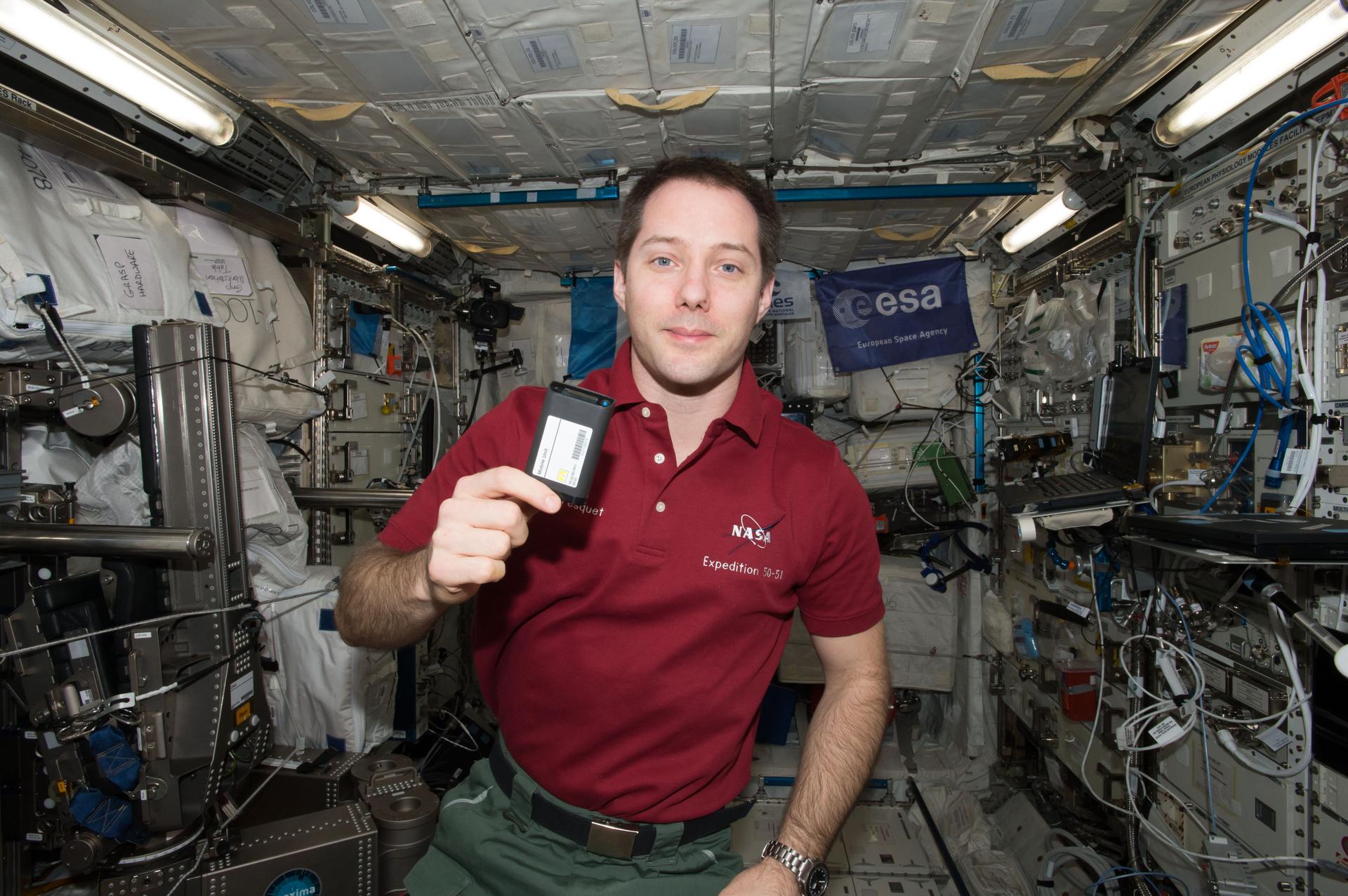
ESA (European Space Agency) astronaut Thomas Pesquet holds a mobile unit for the ESA-Active-Dosimeters experiment.NASAActive-Dosimeters, an investigation led by ESA (European Space Agency), tested a wearable system to measure radiation exposure to crew members on the space station and how it changes with the station’s orbit and altitude. Data from the wearable dosimeter improved radiation risk assessments and could lead to better protection for astronauts, including the ability to quickly respond to changes in exposure throughout future exploration missions.
Robot HelpersOn future exploration missions, robotic technology can help crew members with basic tasks, monitor and maintain equipment, and conduct operations such as sample collection, reducing the need to expose astronauts to harsh environments. Integrated System for Autonomous and Adaptive Caretaking demonstrates using autonomous robots to transfer and unpack cargo and to track and respond to maintenance issues such as leaks and fires, which could protect valuable equipment and reduce costly repairs on future missions. The investigation uses the space station’s Astrobee and Robonaut robots.
NASA astronaut Chris Cassidy sets up a test with an Astrobee robotic assistant.NASAMulti-Resolution Scanning uses the station’s Astrobees to test sensors and robotics to support automated 3D sensing, mapping, and situational awareness functions. On future Gateway and lunar surface missions, such systems could automatically detect defects and conduct remote maintenance and autonomous operation of vehicles such as rovers.
ESA (European Space Agency) astronaut Samantha Cristoforetti practices maneuvers for the Surface Avatar investigation.NASASurface Avatar evaluates crew operation of multiple autonomous robots in space. The investigation also assesses crew member responsiveness to feedback on the consoles used to operate robots remotely, which supports design of effective setups for operating robots on the ground from a spacecraft orbiting above. Results contribute to the development of other uses of robotic assistance such as returning samples from Mars and asteroids.
Melissa Gaskill
International Space Station Research Communications Team
NASA’s Johnson Space Center
Search this database of scientific experiments to learn more about those mentioned above.
Keep Exploring Discover More TopicsSpace Station Research and Technology
Station Science 101: Biology and Biotechnology
Living in Space
Artemis
Share Details Last Updated May 30, 2024 Related TermsHubble Views the Lights of a Galactic Bar
2 min read
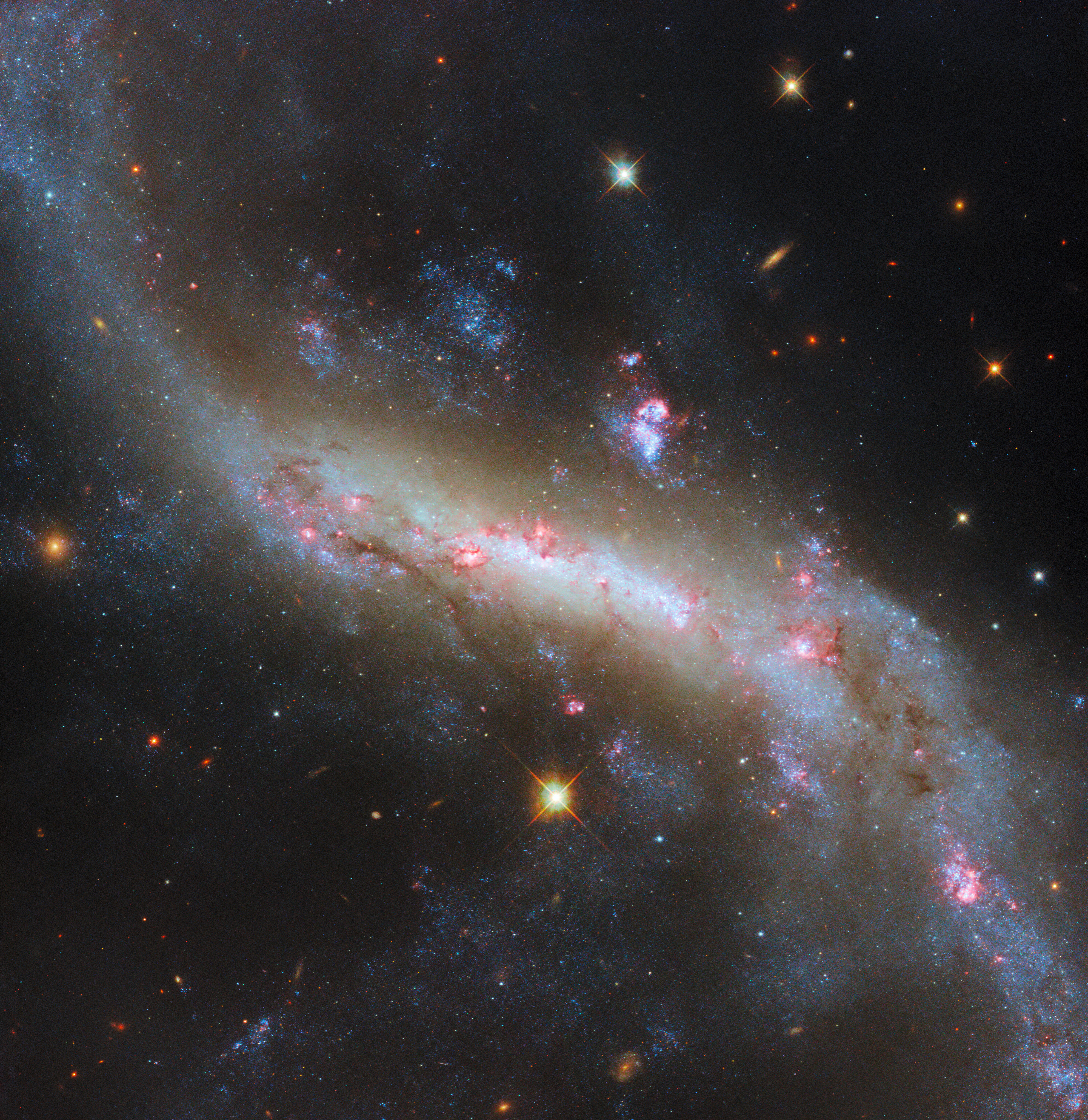
Hubble Views the Lights of a Galactic Bar This Hubble Space Telescope image reveals details in the barred spiral galaxy NGC 4731. ESA/Hubble & NASA, D. ThilkerThis new image from the NASA/ESA Hubble Space Telescope shows the broad and sweeping spiral galaxy NGC 4731. It lies in the constellation Virgo and is located 43 million light-years from Earth. This highly detailed image uses data collected from six different filters. The abundance of color illustrates the galaxy’s billowing clouds of gas, dark dust bands, bright pink star-forming regions and, most obviously, the long, glowing bar with trailing arms.
Barred spiral galaxies outnumber both regular spirals and elliptical galaxies put together, numbering around 60% of all galaxies. The visible bar structure is a result of orbits of stars and gas in the galaxy lining up, forming a dense region that individual stars move in and out of over time. This is the same process that maintains a galaxy’s spiral arms, but it is somewhat more mysterious for bars: spiral galaxies seem to form bars in their centers as they mature, which helps explain the large number of bars we see today, but they can also lose them if the accumulated mass along the bar grows unstable. The orbital patterns and the gravitational interactions within a galaxy that sustain the bar also transport matter and energy into it, fueling star formation. Indeed, the observing program studying NGC 4731 seeks to investigate this flow of matter in galaxies.
Beyond the bar, the spiral arms of NGC 4731 stretch out far past the confines of this close-in Hubble view. Astronomers think the galaxy’s elongated arms are the result of gravitational interactions with other, nearby galaxies in the Virgo cluster.
Text Credit: European Space Agency (ESA)
Download this image
Explore More
Hubble Space Telescope
Tracing the Growth of Galaxies
Galaxy Details and Mergers
Facebook logo @NASAHubble @NASAHubble Instagram logo @NASAHubble
Media Contact:
Claire Andreoli
NASA’s Goddard Space Flight Center, Greenbelt, MD
claire.andreoli@nasa.gov
Since its 1990 launch, the Hubble Space Telescope has changed our fundamental understanding of the universe.
Galaxies Stories
Stars Stories
Dark Matter & Dark Energy
June’s Night Sky Notes: Constant Companions: Circumpolar Constellations, Part III
2 min read
June’s Night Sky Notes: Constant Companions: Circumpolar Constellations, Part IIIby Kat Troche of the Astronomical Society of the Pacific
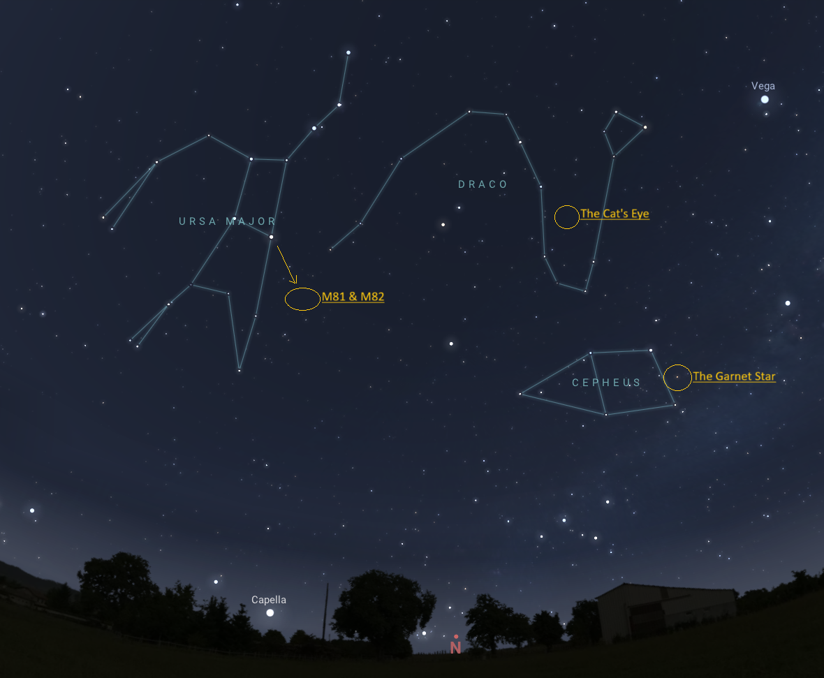
In our final installment of the stars around the North Star, we look ahead to the summer months, where depending on your latitude, the items in these circumpolar constellations are nice and high. Today, we’ll discuss Cepheus, Draco, and Ursa Major. These objects can all be spotted with a medium to large-sized telescope under dark skies.
From left to right: Ursa Major, Draco, and Cepheus. Credit: Stellarium WebHerschel’s Garnet Star: Mu Cephei is a deep-red hypergiant known as The Garnet Star, or Erakis. While the star is not part of the constellation pattern, it sits within the constellation boundary of Cepheus, and is more than 1,000 times the size of our Sun. Like its neighbor Delta Cephei, this star is variable, but is not a reliable Cepheid variable. Rather, its brightness can vary anywhere between 3.4 to 5.1 in visible magnitude, over the course of 2-12 years.
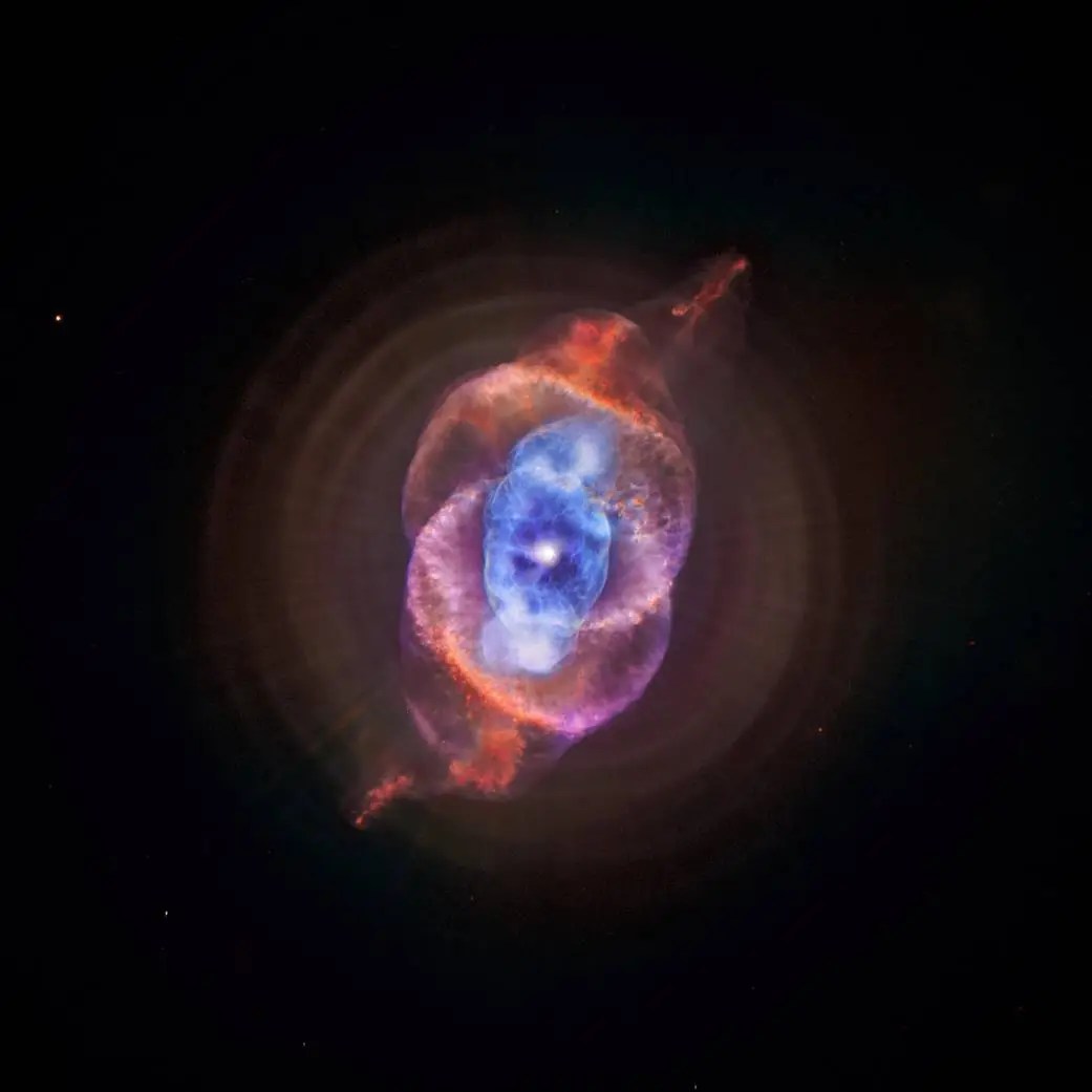
This composite of data from NASA’s Chandra X-ray Observatory and Hubble Space Telescope gives astronomers a new look for NGC 6543, better known as the Cat’s Eye nebula. This planetary nebula represents a phase of stellar evolution that our sun may well experience several billion years from now. Credit: X-ray: NASA/CXC/SAO; Optical: NASA/STScIThe Cat’s Eye Nebula: Labeled a planetary nebula, there are no planets to be found at the center of this object. Observations taken with NASA’s Chandra X-ray Observatory and Hubble Space Telescopes give astronomers a better understanding of this complex, potential binary star, and how its core ejected enough mass to produce the rings of dust. When searching for this object, look towards the ‘belly’ of Draco with a medium-sized telescope.
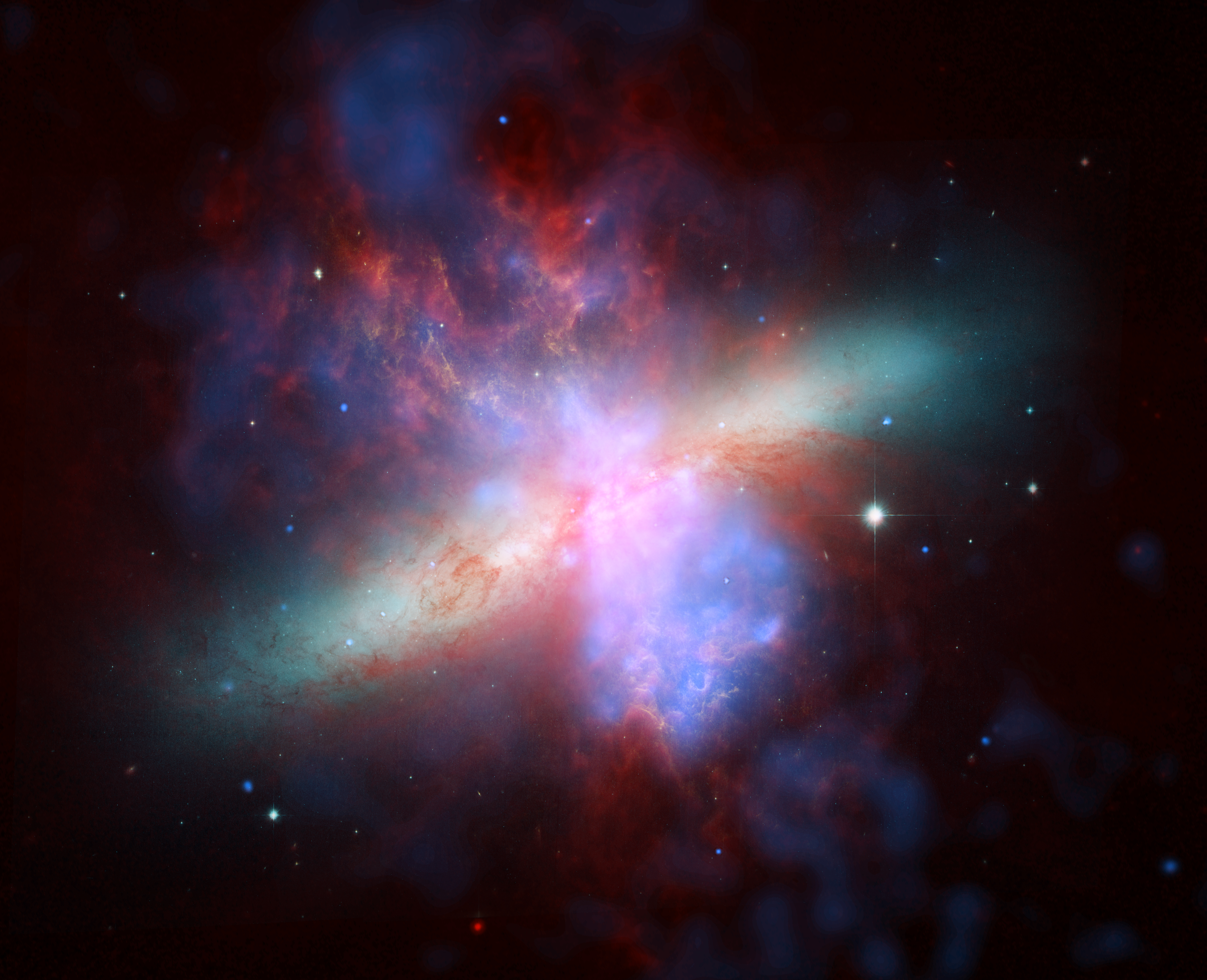
NASA’s Spitzer, Hubble, and Chandra space observatories teamed up to create this multi-wavelength view of the M82 galaxy. The lively portrait celebrates Hubble’s “sweet sixteen” birthday .X-ray data recorded by Chandra appears in blue; infrared light recorded by Spitzer appears in red; Hubble’s observations of hydrogen emission appear in orange, and the bluest visible light appears in yellow-green. Credit: NASA, ESA, CXC, and JPL-CaltechBode’s Galaxy and the Cigar Galaxy: Using the arrow on the star map, look diagonal from the star Dubhe in Ursa Major. There you will find Bode’s Galaxy (Messier 81) and the Cigar Galaxy (Messier 82). Sometimes referred to as Bode’s Nebula, these two galaxies can be spotted with a small to medium-sized telescope. Bode’s Galaxy is a classic spiral shape, similar to our own Milky Way galaxy and our neighbor, Andromeda. The Cigar Galaxy, however, is known as a starburst galaxy type, known to have a high star formation rate and incredible shapes. This image composite from 2006 combines the power of three great observatories: the Hubble Space Telescope imaged hydrogen in orange, and visible light in yellow green; Chandra X-Ray Observatory portrayed X-ray in blue; Spitzer Space Telescope captured infrared light in red.
Up next, we celebrate the solstice with our upcoming mid-month article on the Night Sky Network page through NASA’s website!
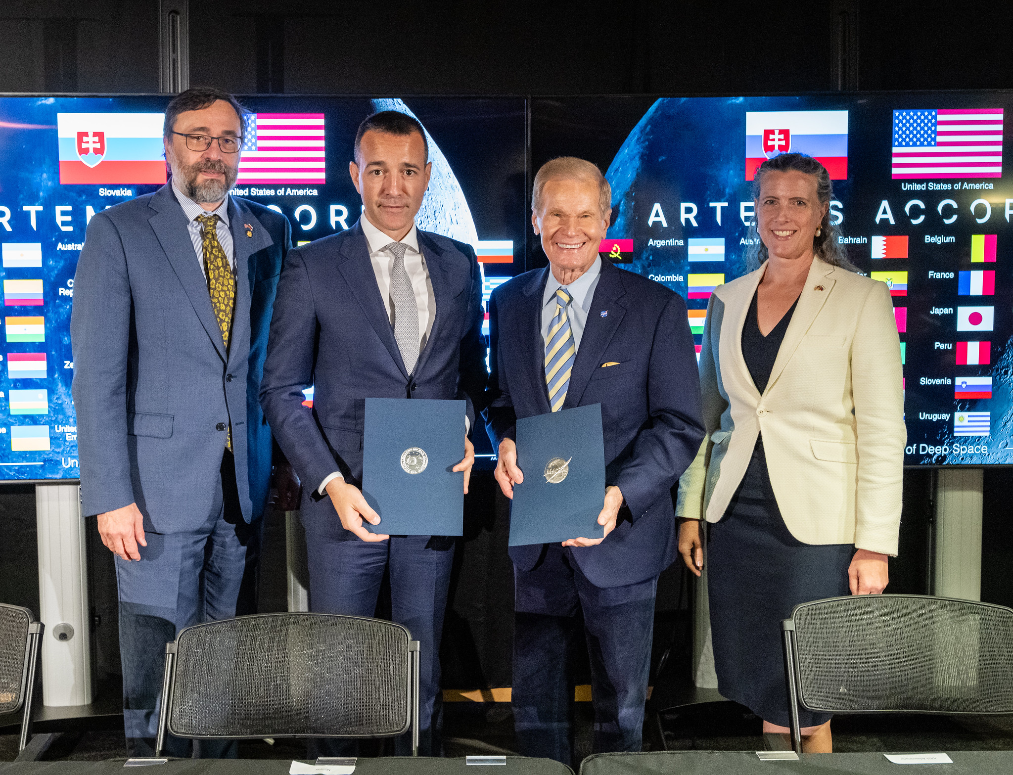
NASA Welcomes Slovakia as New Artemis Accords Signatory
Slovakia signed the Artemis Accords Thursday during a ceremony hosted by NASA Administrator Bill Nelson at the agency’s headquarters in Washington, becoming the 42nd nation to join an international community in a commitment to peaceful, transparent, and responsible exploration of space for the benefit of all.
“NASA welcomes Slovakia as the newest signatory of the Artemis Accords,” said Nelson. “The United States and Slovakia share a deep understanding of the power of exploration. Through this new chapter in our nations’ partnership, we will further this global coalition to explore the cosmos openly, responsibly, in peace.”
Tomáš Drucker, Minister of Education, Research, Development, and Youth signed the Accords on behalf of Slovakia. Sonata Coulter, deputy assistant secretary for the Bureau of European and Eurasian Affairs, U.S. State Department, and Radovan Javorcik, ambassador of the Slovak Republic to the U.S., also participated in the signing ceremony.
“Slovakia perceives the Artemis Accords as a great opportunity for this generation to positively define guidelines and principles for the responsible and sustainable exploration and use of outer space,” said Drucker.
Earlier Thursday, Peru became the 41st country to sign the Artemis Accords. The United States and seven other nations were the first to sign the Artemis Accords in 2020, which identified an early set of principles promoting the beneficial use of space for all humanity. The accords are grounded in the Outer Space Treaty and other agreements including the Registration Convention, the Rescue and Return Agreement, as well as best practices and norms of responsible behavior that NASA and its partners have supported, including the public release of scientific data.
Several accords signatories also met face-to-face for a workshop in May to continue implementing the principles. The commitments of the Artemis Accords, and the efforts by the signatories to advance implementation of these principles, support NASA’s Artemis campaign with its partners, as well as for the success of the safe and sustainable exploration activities of the other Accords signatories.
For more information on the Artemis Accords, visit:
https://www.nasa.gov/artemis-accords
-end-
Faith McKie / Jennifer Dooren
Headquarters, Washington
202-358-1600
faith.d.mckie@nasa.gov / jennifer.m.dooren@nasa.gov
What’s Up: June 2024 Skywatching Tips from NASA
Planets rule the a.m., and what’s that bright light?
Saturn and Mars meet up with the Moon, Jupiter returns at dawn, and tips for identifying some common objects seen in the sky.
Highlights- All month – All the planetary action continues to be in the morning sky, with Saturn and Mars rising in the early morning hours. They are joined later in the month by Jupiter.
- June 2 – In the hour before sunrise, reddish Mars hangs just beneath the crescent Moon. Find the pair low in the east with Saturn lurking nearby, toward the south.
- June 3 – The crescent Moon sits beneath Mars in morning twilight. Look for them low in the eastern sky.
- June 6 – New moon
- June 21 – Full moon
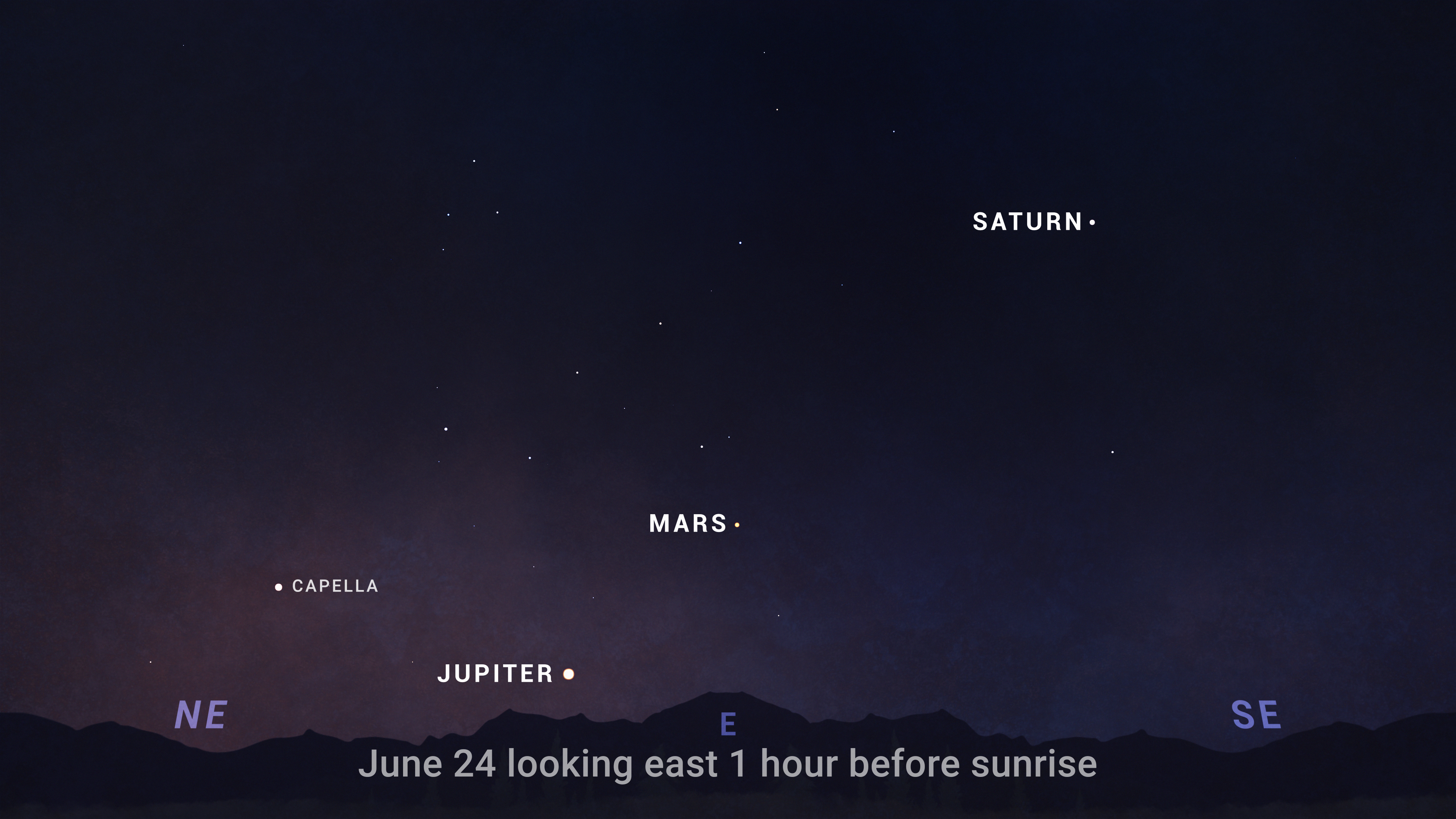
- June 24 – Jupiter is now visible low in the east before sunrise. Look for the bright planet around 10 degrees above the horizon this final week of June, forming a line with Mars and Saturn that stretches toward the south.
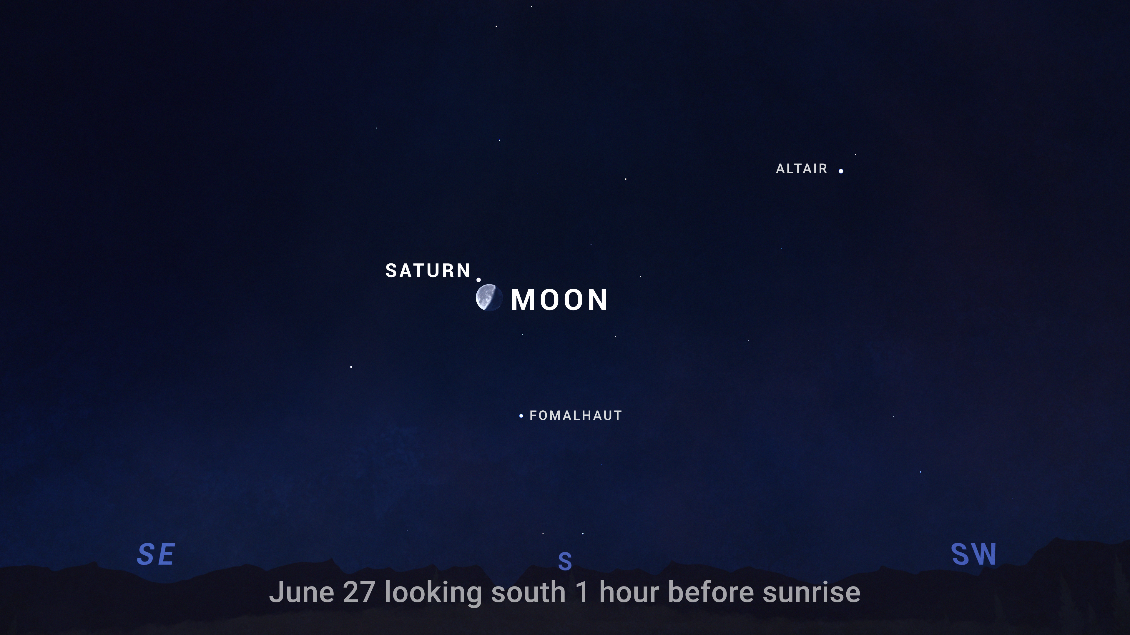
- June 27 – Look for the Moon rising in the east with Saturn around midnight. By dawn this morning, you’ll find them high in the southern sky. They appear super close together – close enough to appear in the same field of view through binoculars.
“Planet Parade” note: Some online sources have shared excitement about a “parade of planets” visible in the morning sky in early June (June 3 in particular). In reality, only two of the six planets supposedly on display (Saturn and Mars) will actually be visible. In early June, Jupiter and Mercury will be at or below the horizon in morning twilight and not visible; Uranus and Neptune are far too faint to see without a telescope, especially as the morning sky brightens. The closest thing to a planet parade will be June 29, when Saturn, the Moon, Mars, and Jupiter will line up across the morning sky. This arrangement persists into July, and we’ll talk more about that lineup in the next “What’s Up” video.
Sky chart showing the planets’ Saturn, Mars, and Jupiter forming a diagonal line across the morning sky in late June. TranscriptWhat’s Up for June? Saturn and Mars meet up with the Moon, Jupiter returns at dawn, and tips for identifying some common objects seen in the sky.
On June 2nd in the hour before sunrise, reddish Mars hangs beneath the crescent Moon. Find the pair low in the east with Saturn lurking nearby. The following morning, on June 3rd, the Moon has moved so that it sits beneath Mars.
During the last week of June, giant Jupiter re-emerges as a morning planet, after passing behind the Sun, from our point of view on Earth, over the past couple of months. By June 24th, you can find it about 10 degrees above the horizon as the morning sky begins to brighten. It climbs a little higher each morning after that as July approaches.
Then on June 27th, look for the Moon with Saturn. The pair rise around midnight, and by dawn you’ll find them high in the southern sky. They appear super close together this morning – close enough to appear in the same field of view through binoculars.
Sky chart showing the pre-dawn sky on June 3, with Saturn, Mars, and the crescent Moon. NASA/JPL-CaltechWhen you spot bright or moving objects in the night sky, it might not be immediately clear what you’re looking at. Is that a planet, or just a bright star? Is it a satellite, or maybe just an airplane? Here are a few quick tips on how to tell the difference.
First, there are five planets that are easily observed with the unaided eye. Of these, two planets – Venus and Jupiter – can sometimes appear incredibly bright, like shining beacons in the sky. The other planets are much less bright, but still generally shine as brightly as bright stars.
The big tipoff that you’re looking at a star and not a planet is that planets tend to shine steadily, whereas stars twinkle. Stars are so far away that they’re just points of light,
and ripples in our atmosphere easily distort them, causing the familiar flicker. The planets are relatively closeby, being here in our solar system. Through binoculars or a telescope, instead of a single point, planets show us a tiny disk or crescent that’s illuminated by the Sun. So even though they appear star-like to the eye, the light from a planet is coming from a slightly more spread-out area, making planets appear more constant in brightness. Both planets and stars rise in the east and set in the west, and they move very slowly across the sky during the night.
But what if you see an object that’s moving? Distant aircraft are usually pretty easy to identify, because they follow a slow, steady path that’s straight or gently curving. They have exterior lights that flash in a regular pattern, often including a red beacon.
Satellites tend to be most visible in the hour or so after dark or before dawn, when it’s night here on the surface, but the satellites are high enough in the sky to be illuminated by sunlight. They’re generally fainter than aircraft, and move in slow, very steady, very straight paths. They might briefly flare in brightness, but they don’t have lights that blink.
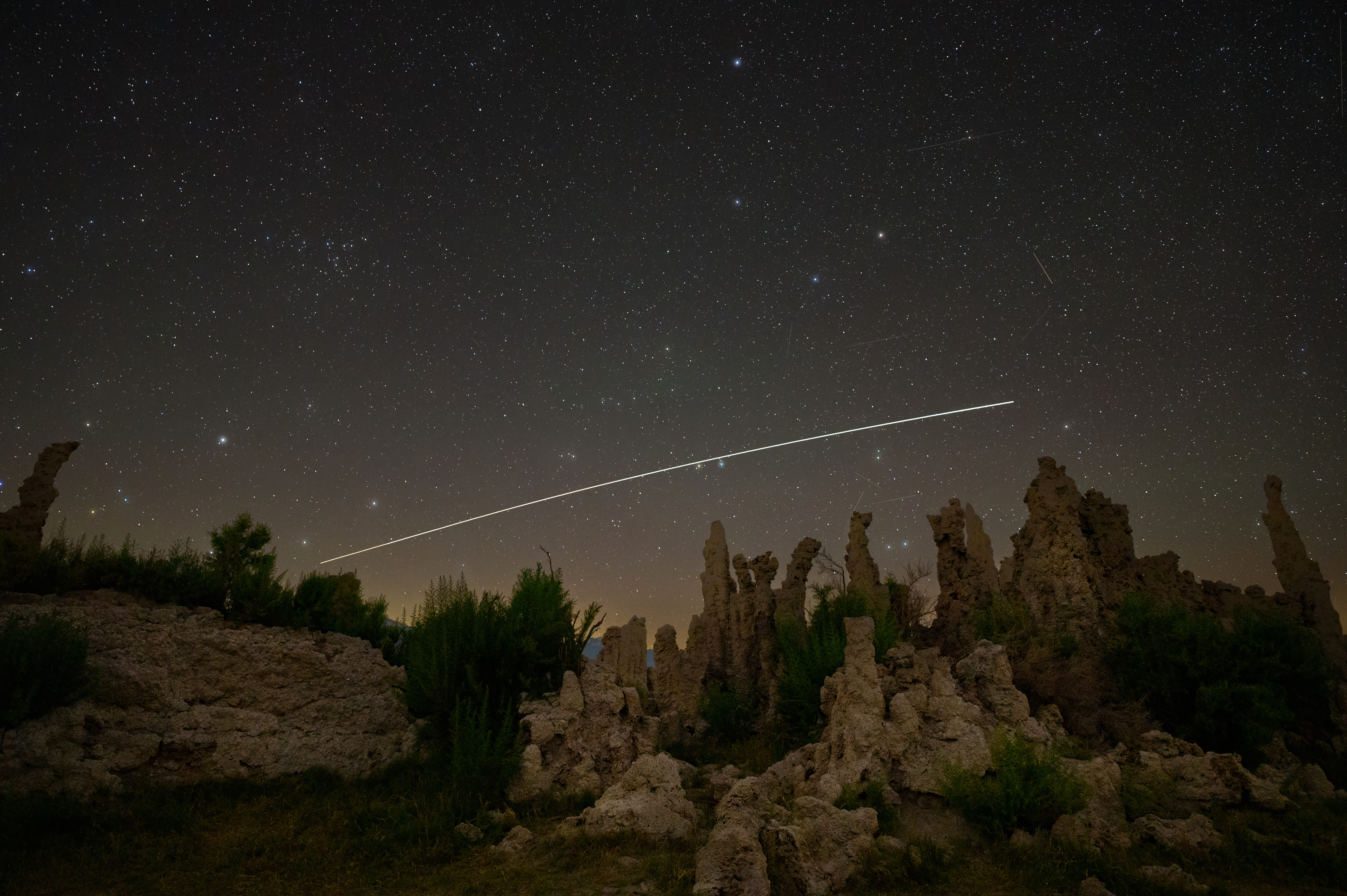
The International Space Station traces its path across the twilight sky over a California desert landscape. NASA/Preston DychesThe International Space Station is an exception, because it’s very bright, and is often visible for long enough to observe the curving path of its orbit. But it doesn’t have flashing lights you can see from the ground, and it does something else satellites do: Satellites often fade out of view as they travel into Earth’s shadow, or fade into view as they emerge. And occasionally you might see a train of satellites moving slowly and silently in formation.
One other sight that’s sometimes confusing is rocket launches that happen soon after sunset or before sunrise. Similar to spotting satellites, this is when it’s darker here on the ground, but launching rockets climb high enough to be illuminated by sunlight. When rockets launching at these times of day get really high in altitude, their exhaust can be brilliantly illuminated, and sometimes you might even see spiral or circular shapes that slowly grow and then dissipate, as a spent rocket stage empties its propellant into space.
With so much to see in the night sky, it’s helpful to be familiar with some of these common sights, so you can get on with your skywatching and investigate whatever mysteries and wonders you’re in search of.
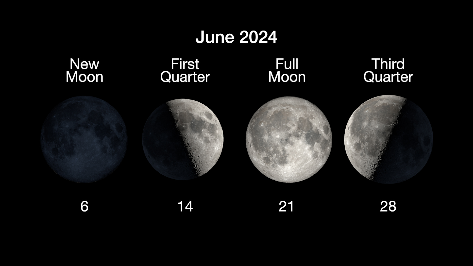
Here are the phases of the Moon for June.
The phases of the Moon for June 2024. NASA/JPL-CaltechStay up to date on NASA’s missions exploring the solar system and beyond at science.nasa.gov. I’m Preston Dyches from NASA’s Jet Propulsion Laboratory, and that’s What’s Up for this month.
NASA Releases New High-Quality, Near Real-Time Air Quality Data
NASA has made new data available that can provide air pollution observations at unprecedented resolutions – down to the scale of individual neighborhoods. The near real-time data comes from the agency’s TEMPO (Tropospheric Emissions: Monitoring of Pollution) instrument, which launched last year to improve life on Earth by revolutionizing the way scientists observe air quality from space. This new data is available from the Atmospheric Science Data Center at NASA’s Langley Research Center in Hampton, Virginia.
“TEMPO is one of NASA’s Earth observing instruments making giant leaps to improve life on our home planet,” said NASA Administrator Bill Nelson. “NASA and the Biden-Harris Administration are committed to addressing the climate crisis and making climate data more open and available to all. The air we breathe affects everyone, and this new data is revolutionizing the way we track air quality for the benefit of humanity.”
To view this video please enable JavaScript, and consider upgrading to a web browser that supports HTML5 video
The TEMPO instrument measured elevated levels of nitrogen dioxide (NO2) from a number of different areas and emission sources throughout the daytime on March 28, 2024. Yellow, red, purple, and black clusters represent increased levels of pollutants from TEMPO’s data and show drift over time. Credit: Trent Schindler/NASA’s Scientific Visualization StudioThe TEMPO mission gathers hourly daytime scans of the atmosphere over North America from the Atlantic Ocean to the Pacific Coast, and from Mexico City to central Canada. The instrument detects pollution by observing how sunlight is absorbed and scattered by gases and particles in the troposphere, the lowest layer of Earth’s atmosphere.
“All the pollutants that TEMPO is measuring cause health issues,” said Hazem Mahmoud, science lead at NASA Langley’s Atmospheric Science Data Center. “We have more than 500 early adopters using these datasets right away. We expect to see epidemiologists and health experts using this data in the near future. Researchers studying the respiratory system and the impact of these pollutants on people’s health will find TEMPO’s measurements invaluable.”
To view this video please enable JavaScript, and consider upgrading to a web browser that supports HTML5 video
NO2 levels are elevated along major traffic corridors including I-35 in Texas with the highest levels between 9:00 a.m. and 12:00 p.m. Elevated NO2 levels are shown across cities including Houston, Dallas, and San Antonio, with the highest levels persisting across Houston from morning to evening. Credit: Trent Schindler/NASA’s Scientific Visualization StudioAn early adopter program has allowed policymakers and other air quality stakeholders to understand the capabilities and benefits of TEMPO’s measurements. Since October 2023, the TEMPO calibration and validation team has been working to evaluate and improve TEMPO data products.
We have more than 500 early adopters that will be using these datasets right away.hazem mahmoud
NASA Data Scientist
“Data gathered by TEMPO will play an important role in the scientific analysis of pollution,” said Xiong Liu, senior physicist at the Smithsonian Astrophysical Observatory and principal investigator for the mission. “For example, we will be able to conduct studies of rush hour pollution, linkages of diseases and health issues to acute exposure of air pollution, how air pollution disproportionately impacts underserved communities, the potential for improved air quality alerts, the effects of lightning on ozone, and the movement of pollution from forest fires and volcanoes.”
Measurements by TEMPO include air pollutants such as nitrogen dioxide, formaldehyde, and ground-level ozone.
To view this video please enable JavaScript, and consider upgrading to a web browser that supports HTML5 video
High NO2 levels associated with prescribed burns are seen popping up across East Texas, Oklahoma, Louisiana, Arkansas, and Mississippi, beginning around 1:00 p.m. and extending into the evening. Elevated NO2 levels are visible in cities from El Paso to Memphis.Credit: Trent Schindler/NASA’s Scientific Visualization Studio“Poor air quality exacerbates pre-existing health issues, which leads to more hospitalizations,” said Jesse Bell, executive director at the University of Nebraska Medical Center’s Water, Climate, and Health Program. Bell is an early adopter of TEMPO’s data.
Bell noted that there is a lack of air quality data in rural areas since monitoring stations are often hundreds of miles apart. There is also an observable disparity in air quality from neighborhood to neighborhood.
“Low-income communities, on average, have poorer air quality than more affluent communities,” said Bell. “For example, we’ve conducted studies and found that in Douglas County, which surrounds Omaha, the eastern side of the county has higher rates of pediatric asthma hospitalizations. When we identify what populations are going to the hospital at a higher rate than others, it’s communities of color and people with indicators of poverty. Data gathered by TEMPO is going to be incredibly important because you can get better spatial and temporal resolution of air quality across places like Douglas County.”
Determining sources of air pollution can be difficult as smoke from wildfires or pollutants from industry and traffic congestion drift on winds. The TEMPO instrument will make it easier to trace the origin of some pollutants.
To view this video please enable JavaScript, and consider upgrading to a web browser that supports HTML5 video
TEMPO observes the northerly transport of NO2 from the Permian basin, a large oil and natural gas producing area spanning parts of West Texas and southeastern New Mexico, with the highest levels measured during the morning over the basin. NO2 plumes from coal-fired power plants are visible in the rural areas far west and northwest of Houston and far east of Dallas between 8:00 a.m. and 2:00 p.m.Credit: Trent Schindler/NASA’s Scientific Visualization Studio“The National Park Service is using TEMPO data to gain new insight into emerging air quality issues at parks in southeast New Mexico,” explained National Park Service chemist, Barkley Sive. “Oil and gas emissions from the Permian Basin have affected air quality at Carlsbad Caverns and other parks and their surrounding communities. While pollution control strategies have successfully decreased ozone levels across most of the United States, the data helps us understand degrading air quality in the region.”
The TEMPO instrument was built by BAE Systems, Inc., Space & Mission Systems (formerly Ball Aerospace) and flies aboard the Intelsat 40e satellite built by Maxar Technologies. The TEMPO Ground System, including the Instrument Operations Center and the Science Data Processing Center, are operated by the Smithsonian Astrophysical Organization, part of the Center for Astrophysics | Harvard & Smithsonian.
Read MoreTo learn more about TEMPO visit: https://nasa.gov/tempo
Facebook logo @NASA@nasalarc @NASA@NASA_Langley Instagram logo @NASA@NASA_Langley Linkedin logo @NASA@company/nasa-langley-research-center Share Details Last Updated May 31, 2024 Related Terms Explore More 4 min read NASA Mission Flies Over Arctic to Study Sea Ice Melt Causes Article 35 mins ago 5 min read Twin NASA Satellites Ready to Help Gauge Earth’s Energy Balance Article 24 hours ago 2 min read Tech Today: Measuring the Buzz, Hum, and RattleNASA-supported wireless microphone array quickly, cheaply, and accurately maps noise from aircraft, animals, and more.
Article 2 days agoNASA Updates Coverage for Boeing’s Starliner Launch, Docking
NASA will provide live coverage of prelaunch and launch activities for the agency’s Boeing Crew Flight Test, which will carry NASA astronauts Butch Wilmore and Suni Williams to and from the International Space Station.
Launch of the ULA (United Launch Alliance) Atlas V rocket and Boeing Starliner spacecraft is targeted for 12:25 p.m. EDT Saturday, June 1, from Space Launch Complex-41 at Cape Canaveral Space Force Station in Florida. Starliner will dock to the forward-facing port of the station’s Harmony module at approximately 1:50 p.m., Sunday, June 2.
Wilmore and Williams will remain at the space station for about a week to test the Starliner spacecraft and its subsystems before NASA works to complete final certification of the transportation system for rotational missions to the orbiting laboratory as part of the agency’s Commercial Crew Program.
NASA, Boeing, and ULA scrubbed the previous launch opportunity on May 6 due to a suspect oxygen relief valve on the Atlas V rocket’s Centaur second stage. Since, teams have removed and replaced the valve, and completed an assessment of Starliner’s performance and redundancy after discovering a small helium leak in the spacecraft’s service module.
As part of the helium leak investigation, NASA and Boeing conducted a follow-on propulsion system assessment to understand potential helium system impacts to some Starliner return scenarios. NASA also completed a Delta-Agency Flight Test Readiness Review on May 29 to evaluate all work performed and flight rationale before proceeding toward launch.
The deadline for media accreditation for in-person coverage of this launch has passed. The agency’s media credentialing policy is available online. For questions about media accreditation, please email: ksc-media-accreditat@mail.nasa.gov.
NASA’s mission coverage is as follows (all times Eastern and subject to change based on real-time operations):
Friday, May 31
1 p.m. – Prelaunch briefing with the following participants:
- NASA Associate Administrator Jim Free
- Steve Stich, manager, NASA’s Commercial Crew Program
- Dana Weigel, manager, NASA’s International Space Station Program
- NASA astronaut Mike Fincke
- Mark Nappi, vice president and program manager, Commercial Crew Program, Boeing
- Gary Wentz, vice president, Government and Commercial Programs, ULA
- Mark Burger, launch weather officer, 45th Weather Squadron, Cape Canaveral Space Force Station
Coverage of the briefing will stream live on NASA+, NASA Television, the NASA app, YouTube, and the agency’s website.
Media may ask questions in person and via phone. Limited auditorium space will be available for in-person participation. For the dial-in number and passcode, media should contact the newsroom at NASA’s Kennedy Space Center in Florida no later than one hour before the start of the event at ksc-newsroom@mail.nasa.gov.
Saturday, June 1
8:15 a.m. – Launch coverage begins on NASA+, NASA Television, the NASA app, YouTube, and the agency’s website.
12:25 p.m. – Launch
Launch coverage on NASA+ will end shortly after Starliner orbital insertion. NASA Television will provide continuous coverage leading up to docking and through hatch opening and welcome remarks.
2 p.m. – Postlaunch news conference with the following participants:
- NASA Administrator Bill Nelson
- Ken Bowersox, associate administrator, NASA’s Space Operations Mission Directorate
- Steve Stich, manager, NASA’s Commercial Crew Program
- Dana Weigel, manager, NASA’s International Space Station Program
- Mark Nappi, vice president and program manager, Commercial Crew Program, Boeing
- Tory Bruno, president and CEO, ULA
Coverage of the postlaunch news conference will air live on NASA+, NASA Television, the NASA app, YouTube, and the agency’s website.
Media may ask questions in person and via phone. Limited auditorium space will be available for in-person participation. For the dial-in number and passcode, media should contact the Kennedy newsroom no later than three hours before the start of the event at ksc-newsroom@mail.nasa.gov.
NASA+ will resume coverage and NASA Television’s public channel will break from in-orbit coverage to carry the postlaunch news conference. Mission operational coverage will continue on NASA Television’s media channel and the agency’s website. Once the postlaunch news conference is complete, NASA+ coverage will end, and mission coverage will continue on both NASA channels.
Sunday, June 2
11:15 a.m. – Arrival coverage resumes on NASA+, the NASA app, and YouTube, and continues on NASA Television and the agency’s website.
1:50 p.m. – Targeted docking to the forward-facing port of the station’s Harmony module
3:35 p.m. – Hatch opening
3:55 p.m. – Welcome remarks
5 p.m. – Post-docking news conference at NASA’s Johnson Space Center with the following participants:
- NASA Associate Administrator Jim Free
- Steve Stich, manager, NASA’s Commercial Crew Program
- Dana Weigel, manager, NASA’s International Space Station Program
- Mark Nappi, vice president and program manager, Commercial Crew Program, Boeing
Coverage of the post-docking news conference will air live on NASA+, NASA Television, the NASA app, YouTube, and the agency’s website.
All times are estimates and could be adjusted based on operations after launch. Follow the space station blog for the most up-to-date operations information.
Audio Only Coverage
Audio only of the news conferences and launch coverage will be carried on the NASA “V” circuits, which may be accessed by dialing 321-867-1220, -1240 or -7135. On launch day, “mission audio,” countdown activities without NASA Television launch commentary, will be carried on 321-867-7135.
Launch audio also will be available on Launch Information Service and Amateur Television System’s VHF radio frequency 146.940 MHz and KSC Amateur Radio Club’s UHF radio frequency 444.925 MHz, FM mode, heard within Brevard County on the Space Coast.
Live Video Coverage Prior to Launch
NASA will provide a live video feed of Space Launch Complex-41 approximately 48 hours prior to the planned liftoff of the mission. Pending unlikely technical issues, the feed will be uninterrupted until the prelaunch broadcast begins on NASA Television, approximately four hours prior to launch. Once the feed is live, find it on NASA Kennedy’s YouTube: http://youtube.com/kscnewsroom.
NASA Website Launch Coverage
Launch day coverage of the mission will be available on the agency’s website. Coverage will include live streaming and blog updates beginning no earlier than 8:15 a.m., June 1, as the countdown milestones occur. On-demand streaming video and photos of the launch will be available shortly after liftoff.
For questions about countdown coverage, contact the Kennedy newsroom at 321-867-2468. Follow countdown coverage on the commercial crew or the Crew Flight Test blog.
Attend Launch Virtually
Members of the public can register to attend this launch virtually. NASA’s virtual guest program for this mission also includes curated launch resources, notifications about related opportunities or changes, and a stamp for the NASA virtual guest passport following launch.
Watch, Engage on Social Media
Let people know you’re following the mission on X, Facebook, and Instagram by using the hashtags #Starliner and #NASASocial. You can also stay connected by following and tagging these accounts:
X: @NASA, @NASAKennedy, @NASASocial, @Space_Station, @ISS_Research, @ISS National Lab, @BoeingSpace, @Commercial_Crew
Facebook: NASA, NASAKennedy, ISS, ISS National Lab
Instagram: @NASA, @NASAKennedy, @ISS, @ISSNationalLab
Coverage en Espanol
Did you know NASA has a Spanish section called NASA en Espanol? Check out NASA en Espanol on X, Instagram, Facebook, and YouTube for additional mission coverage.
Para obtener información sobre cobertura en español en el Centro Espacial Kennedy o si desea solicitar entrevistas en español, comuníquese con Antonia Jaramillo: 321-501-8425;antonia.jaramillobotero@nasa.gov.
NASA’s Commercial Crew Program has delivered on its goal of safe, reliable, and cost-effective transportation to and from the International Space Station from the United States through a partnership with American private industry. This partnership is changing the arc of human spaceflight history by opening access to low-Earth orbit and the International Space Station to more people, science, and commercial opportunities. The space station remains the springboard to NASA’s next great leap in space exploration, including future missions to the Moon and, eventually, to Mars.
For NASA’s launch blog and more information about the mission, visit:
https://www.nasa.gov/commercialcrew
-end-
Jimi Russell / Claire O’Shea
Headquarters, Washington
202-358-1100
james.j.russell@nasa.gov / claire.a.o’shea@nasa.gov
Steven Siceloff / Danielle Sempsrott / Stephanie Plucinsky
Kennedy Space Center, Florida
321-867-2468
steven.p.siceloff@nasa.gov / danielle.c.sempsrott@nasa.gov / stephanie.n.plucinsky@nasa.gov
Leah Cheshier
Johnson Space Center, Houston
281-483-5111
leah.d.cheshier@nasa.gov
