
NASA
NASA Goddard Center Director Makenzie Lystrup Set to Depart
On Monday, NASA announced Dr. Makenzie Lystrup, director of NASA’s Goddard Space Flight Center in Greenbelt, Maryland, is set to leave the agency on Friday, Aug. 1.
As center director of Goddard, a role she has held since April 2023, Lystrup also was responsible for guiding the direction and management of multiple other NASA field installations including Wallops Flight Facility in Virginia, Katherine Johnson Independent Verification & Validation Facility in West Virginia, the White Sands Complex in New Mexico, and the Columbia Scientific Balloon Facility in Texas.
“Having served in a variety of science and aerospace civilian and government roles in her career, Makenzie has led development of, and/or contributed to a variety of NASA’s priority science missions including successful operations of our James Webb Space Telescope and Imaging X-Ray Polarimetry Explorer, as well as development of the agency’s Roman Space Telescope, and more,” said Vanessa Wyche, acting NASA associate administrator. “We’re grateful to Makenzie for her leadership at NASA Goddard for more than two years, including her work to inspire a Golden Age of explorers, scientists, and engineers.”
Throughout her time at NASA, Lystrup led Goddard’s workforce, which consists of more than 8,000 civil servants and contractors. Before joining the agency, Lystrup served as senior director for Ball’s Civil Space Advanced Systems and Business Development, where she managed new business activities for NASA, National Oceanic and Atmospheric Administration (NOAA), and other civilian U.S. government agencies as well as for academia and other science organizations. In addition, she served in the company’s Strategic Operations organization, based in Washington where she led Ball’s space sciences portfolio.
Prior to joining Ball, Lystrup worked as an American Institute of Physics – Acoustical Society of American Congressional Fellow from 2011 to 2012 where she managed a portfolio including technology, national defense, nuclear energy, and nuclear nonproliferation.
Lystrup also has served on boards and committees for several organizations to include the University Corporation for Atmospheric Research, International Society for Optics and Photonic, the University of Colorado, and the American Astronomical Society. She was named an American Association for the Advancement of Science fellow in 2019 for her distinguished record in the fields of planetary science and infrared astronomy, science policy and advocacy, and aerospace leadership. Lystrup also served as an AmeriCorps volunteer focusing on STEM education.
Lystrup holds a bachelor’s in physics from Portland State University and attended graduate school at University College London earning her doctorate in astrophysics. She was a National Science Foundation Astronomy & Astrophysics Postdoctoral Research Fellow spending time at the Laboratory for Atmospheric & Space Physics in Boulder, Colorado, and University of Liege in Belgium. As a planetary scientist and astronomer, Lystrup’s scientific work has been in using ground- and space-based astronomical observatories to understand the interactions and dynamics of planetary atmospheres and magnetospheres – the relationships between planets and their surrounding space environments.
Following Lystrup’s departure, NASA’s Cynthia Simmons will serve as acting center director. Simmons is the current deputy center director.
For more information about NASA’s work, visit:
-end-
Cheryl Warner / Kathryn Hambleton
Headquarters, Washington
202-358-1600
cheryl.m.warner@nasa.gov / kathryn.hambleton@nasa.gov
Katy Mersmann
Goddard Space Flight Center, Greenbelt, Md.
301-377-1724
katy.mersmann@nasa.gov
NASA Shares How to Save Camera 370-Million-Miles Away Near Jupiter
5 min read
Preparations for Next Moonwalk Simulations Underway (and Underwater) The north polar region of Jupiter’s volcanic moon Io was captured by the JunoCam imager aboard NASA’s Juno during the spacecraft’s 57th close pass of the gas giant on Dec. 30, 2023. A technique called annealing was used to help repair radiation damage to the camera in time to capture this image. Image data: NASA/JPL-Caltech/SwRI/MSSS Image processing by Gerald EichstädtAn experimental technique rescued a camera aboard the agency’s Juno spacecraft, offering lessons that will benefit other space systems that experience high radiation.
The mission team of NASA’s Jupiter-orbiting Juno spacecraft executed a deep-space move in December 2023 to repair its JunoCam imager to capture photos of the Jovian moon Io. Results from the long-distance save were presented during a technical session on July 16 at the Institute of Electrical and Electronics Engineers Nuclear & Space Radiation Effects Conference in Nashville.
JunoCam is a color, visible-light camera. The optical unit for the camera is located outside a titanium-walled radiation vault, which protects sensitive electronic components for many of Juno’s engineering and science instruments.
This is a challenging location because Juno’s travels carry it through the most intense planetary radiation fields in the solar system. While mission designers were confident JunoCam could operate through the first eight orbits of Jupiter, no one knew how long the instrument would last after that.
Throughout Juno’s first 34 orbits (its prime mission), JunoCam operated normally, returning images the team routinely incorporated into the mission’s science papers. Then, during its 47th orbit, the imager began showing hints of radiation damage. By orbit 56, nearly all the images were corrupted.
The graininess and horizontal lines seen in this JunoCam image show evidence that the camera aboard NASA’s Juno mission suffered radiation damage. The image, which captures one of the circumpolar cyclones on Jupiter’s north pole, was taken Nov. 22, 2023. NASA/JPL-Caltech/SwRI/MSSS Long Distance Microscopic RepairWhile the team knew the issue may be tied to radiation, pinpointing what, specifically, was damaged within JunoCam was difficult from hundreds of millions of miles away. Clues pointed to a damaged voltage regulator that is vital to JunoCam’s power supply. With few options for recovery, the team turned to a process called annealing, where a material is heated for a specified period before slowly cooling. Although the process is not well understood, the idea is that the heating can reduce defects in the material.
“We knew annealing can sometimes alter a material like silicon at a microscopic level but didn’t know if this would fix the damage,” said JunoCam imaging engineer Jacob Schaffner of Malin Space Science Systems in San Diego, which designed and developed JunoCam and is part of the team that operates it. “We commanded JunoCam’s one heater to raise the camera’s temperature to 77 degrees Fahrenheit — much warmer than typical for JunoCam — and waited with bated breath to see the results.”
Soon after the annealing process finished, JunoCam began cranking out crisp images for the next several orbits. But Juno was flying deeper and deeper into the heart of Jupiter’s radiation fields with each pass. By orbit 55, the imagery had again begun showing problems.
“After orbit 55, our images were full of streaks and noise,” said JunoCam instrument lead Michael Ravine of Malin Space Science Systems. “We tried different schemes for processing the images to improve the quality, but nothing worked. With the close encounter of Io bearing down on us in a few weeks, it was Hail Mary time: The only thing left we hadn’t tried was to crank JunoCam’s heater all the way up and see if more extreme annealing would save us.”
Test images sent back to Earth during the annealing showed little improvement the first week. Then, with the close approach of Io only days away, the images began to improve dramatically. By the time Juno came within 930 miles (1,500 kilometers) of the volcanic moon’s surface on Dec. 30, 2023, the images were almost as good as the day the camera launched, capturing detailed views of Io’s north polar region that revealed mountain blocks covered in sulfur dioxide frosts rising sharply from the plains and previously uncharted volcanos with extensive flow fields of lava.
Testing LimitsTo date, the solar-powered spacecraft has orbited Jupiter 74 times. Recently, the image noise returned during Juno’s 74th orbit.
Since first experimenting with JunoCam, the Juno team has applied derivations of this annealing technique on several Juno instruments and engineering subsystems.
“Juno is teaching us how to create and maintain spacecraft tolerant to radiation, providing insights that will benefit satellites in orbit around Earth,” said Scott Bolton, Juno’s principal investigator from the Southwest Research Institute in San Antonio. “I expect the lessons learned from Juno will be applicable to both defense and commercial satellites as well as other NASA missions.”
More About JunoNASA’s Jet Propulsion Laboratory, a division of Caltech in Pasadena, California, manages the Juno mission for the principal investigator, Scott Bolton, of the Southwest Research Institute in San Antonio. Juno is part of NASA’s New Frontiers Program, which is managed at NASA’s Marshall Space Flight Center in Huntsville, Alabama, for the agency’s Science Mission Directorate in Washington. The Italian Space Agency, Agenzia Spaziale Italiana, funded the Jovian InfraRed Auroral Mapper. Lockheed Martin Space in Denver built and operates the spacecraft. Various other institutions around the U.S. provided several of the other scientific instruments on Juno.
More information about Juno is at:
News Media ContactDC Agle
Jet Propulsion Laboratory, Pasadena, Calif.
818-393-9011
agle@jpl.nasa.gov
Karen Fox / Molly Wasser
NASA Headquarters, Washington
202-358-1600
karen.c.fox@nasa.gov / molly.l.wasser@nasa.gov
Deb Schmid
Southwest Research Institute, San Antonio
210-522-2254
dschmid@swri.org
2025-091
Share Details Last Updated Jul 21, 2025 Related Terms Explore More 6 min read 5 Things to Know About Powerful New U.S.-India Satellite, NISAR Article 1 day ago 6 min read Meet Mineral Mappers Flying NASA Tech Out West Article 2 weeks ago 3 min read NASA Aircraft, Sensor Technology, Aid in Texas Flood Recovery Efforts Article 2 weeks ago Keep Exploring Discover Related TopicsMissions
Humans in Space
Climate Change
Solar System
NASA Shares How to Save Camera 370-Million-Miles Away Near Jupiter
5 min read
Preparations for Next Moonwalk Simulations Underway (and Underwater) The north polar region of Jupiter’s volcanic moon Io was captured by the JunoCam imager aboard NASA’s Juno during the spacecraft’s 57th close pass of the gas giant on Dec. 30, 2023. A technique called annealing was used to help repair radiation damage to the camera in time to capture this image. Image data: NASA/JPL-Caltech/SwRI/MSSS Image processing by Gerald EichstädtAn experimental technique rescued a camera aboard the agency’s Juno spacecraft, offering lessons that will benefit other space systems that experience high radiation.
The mission team of NASA’s Jupiter-orbiting Juno spacecraft executed a deep-space move in December 2023 to repair its JunoCam imager to capture photos of the Jovian moon Io. Results from the long-distance save were presented during a technical session on July 16 at the Institute of Electrical and Electronics Engineers Nuclear & Space Radiation Effects Conference in Nashville.
JunoCam is a color, visible-light camera. The optical unit for the camera is located outside a titanium-walled radiation vault, which protects sensitive electronic components for many of Juno’s engineering and science instruments.
This is a challenging location because Juno’s travels carry it through the most intense planetary radiation fields in the solar system. While mission designers were confident JunoCam could operate through the first eight orbits of Jupiter, no one knew how long the instrument would last after that.
Throughout Juno’s first 34 orbits (its prime mission), JunoCam operated normally, returning images the team routinely incorporated into the mission’s science papers. Then, during its 47th orbit, the imager began showing hints of radiation damage. By orbit 56, nearly all the images were corrupted.
The graininess and horizontal lines seen in this JunoCam image show evidence that the camera aboard NASA’s Juno mission suffered radiation damage. The image, which captures one of the circumpolar cyclones on Jupiter’s north pole, was taken Nov. 22, 2023. NASA/JPL-Caltech/SwRI/MSSS Long Distance Microscopic RepairWhile the team knew the issue may be tied to radiation, pinpointing what, specifically, was damaged within JunoCam was difficult from hundreds of millions of miles away. Clues pointed to a damaged voltage regulator that is vital to JunoCam’s power supply. With few options for recovery, the team turned to a process called annealing, where a material is heated for a specified period before slowly cooling. Although the process is not well understood, the idea is that the heating can reduce defects in the material.
“We knew annealing can sometimes alter a material like silicon at a microscopic level but didn’t know if this would fix the damage,” said JunoCam imaging engineer Jacob Schaffner of Malin Space Science Systems in San Diego, which designed and developed JunoCam and is part of the team that operates it. “We commanded JunoCam’s one heater to raise the camera’s temperature to 77 degrees Fahrenheit — much warmer than typical for JunoCam — and waited with bated breath to see the results.”
Soon after the annealing process finished, JunoCam began cranking out crisp images for the next several orbits. But Juno was flying deeper and deeper into the heart of Jupiter’s radiation fields with each pass. By orbit 55, the imagery had again begun showing problems.
“After orbit 55, our images were full of streaks and noise,” said JunoCam instrument lead Michael Ravine of Malin Space Science Systems. “We tried different schemes for processing the images to improve the quality, but nothing worked. With the close encounter of Io bearing down on us in a few weeks, it was Hail Mary time: The only thing left we hadn’t tried was to crank JunoCam’s heater all the way up and see if more extreme annealing would save us.”
Test images sent back to Earth during the annealing showed little improvement the first week. Then, with the close approach of Io only days away, the images began to improve dramatically. By the time Juno came within 930 miles (1,500 kilometers) of the volcanic moon’s surface on Dec. 30, 2023, the images were almost as good as the day the camera launched, capturing detailed views of Io’s north polar region that revealed mountain blocks covered in sulfur dioxide frosts rising sharply from the plains and previously uncharted volcanos with extensive flow fields of lava.
Testing LimitsTo date, the solar-powered spacecraft has orbited Jupiter 74 times. Recently, the image noise returned during Juno’s 74th orbit.
Since first experimenting with JunoCam, the Juno team has applied derivations of this annealing technique on several Juno instruments and engineering subsystems.
“Juno is teaching us how to create and maintain spacecraft tolerant to radiation, providing insights that will benefit satellites in orbit around Earth,” said Scott Bolton, Juno’s principal investigator from the Southwest Research Institute in San Antonio. “I expect the lessons learned from Juno will be applicable to both defense and commercial satellites as well as other NASA missions.”
More About JunoNASA’s Jet Propulsion Laboratory, a division of Caltech in Pasadena, California, manages the Juno mission for the principal investigator, Scott Bolton, of the Southwest Research Institute in San Antonio. Juno is part of NASA’s New Frontiers Program, which is managed at NASA’s Marshall Space Flight Center in Huntsville, Alabama, for the agency’s Science Mission Directorate in Washington. The Italian Space Agency, Agenzia Spaziale Italiana, funded the Jovian InfraRed Auroral Mapper. Lockheed Martin Space in Denver built and operates the spacecraft. Various other institutions around the U.S. provided several of the other scientific instruments on Juno.
More information about Juno is at:
News Media ContactDC Agle
Jet Propulsion Laboratory, Pasadena, Calif.
818-393-9011
agle@jpl.nasa.gov
Karen Fox / Molly Wasser
NASA Headquarters, Washington
202-358-1600
karen.c.fox@nasa.gov / molly.l.wasser@nasa.gov
Deb Schmid
Southwest Research Institute, San Antonio
210-522-2254
dschmid@swri.org
2025-091
Share Details Last Updated Jul 21, 2025 Related Terms Explore More 6 min read 5 Things to Know About Powerful New U.S.-India Satellite, NISAR Article 16 hours ago 6 min read Meet Mineral Mappers Flying NASA Tech Out West Article 2 weeks ago 3 min read NASA Aircraft, Sensor Technology, Aid in Texas Flood Recovery Efforts Article 2 weeks ago Keep Exploring Discover Related TopicsMissions
Humans in Space
Climate Change
Solar System
GLOBE-Trotting Science Lands in Chesapeake with NASA eClips
2 min read
GLOBE-Trotting Science Lands in Chesapeake with NASA eClipsOn June 16-17, 2025, 50 students at Camp Young in Chesapeake, Virginia traded their usual summer routines for microscopes. The NASA eClips team from the National Institute of Aerospace Center for Integrative STEM Education (NIA-CISE) taught two engaging lessons focused on macroinvertebrates and plankton, with a surprising star of the show – mosquitoes!
Camp Young, a Title I camp program serving students from Norfolk Public Schools, provides year-round, environmental science-based learning. The NASA eClips’ visit reinforced their mission to help students explore their environment on the Elizabeth River while seeing its place in the Earth System.
The lessons, designed for students in grades 3 through 8, were inspired by NASA’s GLOBE (Global Learning and Observations to Benefit the Environment) program, which encourages people around the world to collect and share environmental data as ‘citizen scientists’. This is where mosquitos stole the show! The lesson focuses on how these tiny insects can serve as indicators of climate and habitat change. By identifying mosquito larvae and understanding their breeding environments, students contributed to the bigger picture of global health and environmental monitoring, right from their own backyard.
During this experience, Camp Young’s stunning waterfront on the Elizabeth River was turned into a living laboratory. With phytoplankton nets, petri dishes, and sample jars in hand, campers ventured into the field to collect real environmental data, bringing their findings back to a cabin-turned-classroom to analyze them with scientific tools, including microscopes provided by the NASA eClips team.
Rather than just reading about ecosystems and the kinds of scientific questions that arise within them, students got to experience them firsthand and experience real science in the field. “It’s one thing to talk about microscopic marine organisms,” one instructor noted, “but it’s another thing entirely when students can actually see them swimming in a droplet from the river.”
The NASA eClips project provides educators with standards-based videos, activities, and lessons to increase STEM literacy through the lens of NASA. It is supported by NASA under cooperative agreement award number NNX16AB91A and is part of NASA’s Science Activation Portfolio. Learn more about how Science Activation connects NASA science experts, real content, and experiences with community leaders to do science in ways that activate minds and promote deeper understanding of our world and beyond: https://science.nasa.gov/learn
A student collects a stagnant water sample, looking for mosquito eggs and larvae. Share Details Last Updated Jul 21, 2025 Editor NASA Science Editorial Team Related Terms Explore More 3 min read NASA Citizen Science and Your Career: Stories of Exoplanet Watch VolunteersDoing NASA Science brings many rewards. But can taking part in NASA citizen science help…
Article
5 days ago
4 min read NASA SCoPE Summer Symposium Celebrates Early Career Scientists and Cross-Team Collaboration
Article
6 days ago
4 min read Linking Satellite Data and Community Knowledge to Advance Alaskan Snow Science
Article
1 week ago
Keep Exploring Discover More Topics From NASA James Webb Space Telescope
Webb is the premier observatory of the next decade, serving thousands of astronomers worldwide. It studies every phase in the…
Perseverance Rover
This rover and its aerial sidekick were assigned to study the geology of Mars and seek signs of ancient microbial…
Parker Solar Probe
On a mission to “touch the Sun,” NASA’s Parker Solar Probe became the first spacecraft to fly through the corona…
Juno
NASA’s Juno spacecraft entered orbit around Jupiter in 2016, the first explorer to peer below the planet’s dense clouds to…
The Day Earth Smiled
On July 19, 2013, NASA’s Cassini spacecraft had a rare opportunity to image Saturn and, far in the background, Earth. This image spans about 404,880 miles (651,591 kilometers) across.
With the Sun’s powerful and potentially damaging rays eclipsed by Saturn itself, Cassini’s onboard cameras were able to take advantage of this unique viewing geometry. They acquired a panoramic mosaic of the Saturn system that allows scientists to see details in the rings and throughout the system as they are backlit by the sun. This mosaic is special as it marks the third time our home planet was imaged from the outer solar system; the second time it was imaged by Cassini from Saturn’s orbit; and the first time ever that inhabitants of Earth were made aware in advance that their photo would be taken from such a great distance.
Before the mission ended in 2017, Cassini was already a powerful influence on future exploration. Lessons learned during Cassini’s mission are being applied in NASA’s Europa Clipper mission. The mission uses an orbital tour design derived from the way Cassini explored Saturn. Launched in 2024, Europa Clipper will reach Jupiter in April 2030 and make dozens of flybys of the planet’s icy moon to determine whether there are places below the surface that could support life.
Learn more about this unique image.
Image credit: NASA/JPL-Caltech/SSI
The Day Earth Smiled
5 Things to Know About Powerful New U.S.-India Satellite, NISAR
6 min read
Preparations for Next Moonwalk Simulations Underway (and Underwater) Information provided by the NASA-ISRO Synthetic Aperture Radar mission (NISAR) will help to protect and inform communities around the world. The data will aid in managing agricultural fields, monitoring volcanoes, and tracking land-based ice including glaciers.NASA/JPL-CaltechLee esta historia en español aquí.
Data from NISAR will map changes to Earth’s surface, helping improve crop management, natural hazard monitoring, and tracking of sea ice and glaciers.
A new U.S.-India satellite called NISAR (NASA-ISRO Synthetic Aperture Radar) will provide high-resolution data enabling scientists to comprehensively monitor the planet’s land and ice surfaces like never before, building a detailed record of how they shift over time. Hailed as a critical part of a pioneering year for U.S.-India civil space cooperation by President Trump and Prime Minister Modi during their visit in Washington in February, the NISAR launch will advance U.S.-India cooperation and benefit the U.S. in the areas of disaster response and agriculture.
As the first joint satellite mission between NASA and the Indian Space Research Organisation (ISRO), NISAR marks a new chapter in the growing collaboration between the two space agencies. Years in the making, the launch of NISAR builds on a strong heritage of successful programs, including Chandrayaan-1 and the recent Axiom Mission 4, which saw ISRO and NASA astronauts living and working together aboard the International Space Station for the first time.
The information NISAR provides will help decision-makers, communities, and scientists monitor agricultural fields, refine understanding of natural hazards such as landslides and earthquakes, and help teams prepare for and respond to disasters like hurricanes, floods, and volcanic eruptions. The satellite will also provide key global observations of changes to ice sheets, glaciers, and permafrost, as well as forests and wetlands.
The NISAR mission is slated to launch no earlier than July 30 from Satish Dhawan Space Centre on India’s southeastern coast aboard an ISRO Geosynchronous Satellite Launch Vehicle.
Here are five things to know about NISAR:
1. The NISAR satellite will provide a 3D view of Earth’s land and ice.
Two synthetic aperture radars (SARs) aboard NISAR will detect changes in the planet’s surface down to fractions of an inch. The spacecraft will bounce microwave signals off Earth’s surface and receive the return signals on a radar antenna reflector measuring 39 feet (12 meters) across. The satellite’s ability to “see” through clouds and light rain, day and night, will enable data users to continuously monitor earthquake- and landslide-prone areas and determine how quickly glaciers and ice sheets are changing. It also will offer unprecedented coverage of Antarctica, information that will help with studying how the continent’s ice sheet changes over time.
2. Data from NISAR will provide critical insights to help governments and decision-makers plan for natural and human-caused hazards.
Earthquakes, volcanoes, and aging infrastructure can pose risks to lives and property. Able to see subtle changes in Earth’s surface, NISAR can help with hazard-monitoring efforts and potentially give decision-makers more time to prepare for a possible disaster. For earthquakes, NISAR will provide insights into which parts of a fault slowly move without producing quakes and which are locked together and could potentially slip. The satellite will be able to monitor the area around thousands of volcanoes, detecting land movement that could be a precursor to an eruption. When it comes to infrastructure such as levees, aqueducts, and dams, NISAR data collected over time can help managers detect if nearby land motion could jeopardize key structures, and then assess the integrity of those facilities.
3. The most advanced radar system ever launched as part of a NASA or ISRO mission, NISAR will generate more data on a daily basis than any previous Earth satellite from either agency.
About the length of a pickup truck, NISAR’s main body contains a dual-radar payload — an L-band system with a 10-inch (25-centimeter) wavelength and an S-band system with a 4-inch (10-centimeter) wavelength. Each system is sensitive to land and ice features of different sizes and specializes in detecting certain attributes, such as moisture content, surface roughness, and motion. By including both radars on one spacecraft — a first — NISAR will be more capable than previous SAR missions. These two radars, one from NASA and one from ISRO, and the data they will produce, exemplify how collaboration between spacefaring allies can achieve more than either would alone.
NISAR press kitThe radars will generate about 80 terabytes of data products per day over the course of NISAR’s prime mission. That’s roughly enough data to fill about 150 512-gigabyte hard drives each day. The information will be processed, stored, and distributed via the cloud — and accessible to all.
This artist’s concept depicts the NISAR satellite in orbit over central and Northern California. The spacecraft will survey all of Earth’s land and ice-covered surfaces twice every 12 days.NASA/JPL-Caltech4. The NISAR mission will help monitor ecosystems around the world.
The mission’s two radars will monitor Earth’s land and ice-covered surfaces twice every 12 days. Their near-comprehensive coverage will include areas not previously covered by other Earth-observing radar satellites with such frequency. The NISAR satellite’s L-band radar penetrates deep into forest canopies, providing insights into forest structure, while the S-band radar is ideal for monitoring crops. The NISAR data will help researchers assess how forests, wetlands, agricultural areas, and permafrost change over time.
5. The NISAR mission marks the first collaboration between NASA and ISRO on a project of this scale and marks the next step in a long line of Earth-observing SAR missions.
The NISAR satellite features components developed on opposite sides of the planet by engineers from ISRO and NASA’s Jet Propulsion Laboratory working together. The S-band radar was built at ISRO’s Space Applications Centre in Ahmedabad, while JPL built the L-band radar in Southern California. After engineers from JPL and ISRO integrated NISAR’s instruments with a modified ISRO I3K spacecraft bus and tested the satellite, ISRO transported NISAR to Satish Dhawan Space Centre in May 2025 to prepare it for launch.
The SAR technique was invented in the U.S. in 1952 and now countries around the globe have SAR satellites for a variety of missions. NASA first used the technique with a space-based satellite in 1978 on the ocean-observing Seasat, which included the first spaceborne SAR instrument for scientific observations. In 2012, ISRO began launching SAR missions starting with Radar Imaging Satellite (RISAT-1), followed by RISAT-1A in 2022, to support a wide range of applications in India.
More About NISARManaged by Caltech in Pasadena, JPL leads the U.S. component of the project and provided the L-band SAR. JPL also provided the radar reflector antenna, the deployable boom, a high-rate communication subsystem for science data, GPS receivers, a solid-state recorder, and payload data subsystem. NASA’s Goddard Space Flight Center manages the Near Space Network, which will receive NISAR’s L-band data.
The ISRO Space Applications Centre is providing the mission’s S-band SAR. The U R Rao Satellite Centre is providing the spacecraft bus. The rocket is from Vikram Sarabhai Space Centre, launch services are through Satish Dhawan Space Centre, and satellite mission operations are by the ISRO Telemetry Tracking and Command Network. The National Remote Sensing Centre is responsible for S-band data reception, operational products generation, and dissemination.
To learn more about NISAR, visit:
How New NASA, India Satellite NISAR Will See Earth Powerful New US-Indian Satellite Will Track Earth’s Changing Surface NASA-ISRO Radar Mission to Provide Dynamic View of Forests, Wetlands NASA-ISRO Mission Will Map Farmland From Planting to Harvest News Media ContactsAndrew Wang / Jane J. Lee
Jet Propulsion Laboratory, Pasadena, Calif.
626-379-6874 / 626-491-1943
andrew.wang@jpl.nasa.gov / jane.j.lee@jpl.nasa.gov
2025-090
Share Details Last Updated Jul 21, 2025 Related Terms Explore More 5 min read NASA Shares How to Save Camera 370-Million-Miles Away Near Jupiter Article 22 hours ago 2 min read GLOBE-Trotting Science Lands in Chesapeake with NASA eClipsOn June 16-17, 2025, 50 students at Camp Young in Chesapeake, Virginia traded their usual…
Article 22 hours ago 4 min read Linking Satellite Data and Community Knowledge to Advance Alaskan Snow ScienceSeasonal snow plays a significant role in global water and energy cycles, and billions of…
Article 1 week ago Keep Exploring Discover Related TopicsMissions
Humans in Space
Climate Change
Solar System
5 Things to Know About Powerful New U.S.-India Satellite, NISAR
6 min read
Preparations for Next Moonwalk Simulations Underway (and Underwater) Information provided by the NASA-ISRO Synthetic Aperture Radar mission (NISAR) will help to protect and inform communities around the world. The data will aid in managing agricultural fields, monitoring volcanoes, and tracking land-based ice including glaciers.NASA/JPL-CaltechLee esta historia en español aquí.
Data from NISAR will map changes to Earth’s surface, helping improve crop management, natural hazard monitoring, and tracking of sea ice and glaciers.
A new U.S.-India satellite called NISAR (NASA-ISRO Synthetic Aperture Radar) will provide high-resolution data enabling scientists to comprehensively monitor the planet’s land and ice surfaces like never before, building a detailed record of how they shift over time. Hailed as a critical part of a pioneering year for U.S.-India civil space cooperation by President Trump and Prime Minister Modi during their visit in Washington in February, the NISAR launch will advance U.S.-India cooperation and benefit the U.S. in the areas of disaster response and agriculture.
As the first joint satellite mission between NASA and the Indian Space Research Organisation (ISRO), NISAR marks a new chapter in the growing collaboration between the two space agencies. Years in the making, the launch of NISAR builds on a strong heritage of successful programs, including Chandrayaan-1 and the recent Axiom Mission 4, which saw ISRO and NASA astronauts living and working together aboard the International Space Station for the first time.
The information NISAR provides will help decision-makers, communities, and scientists monitor agricultural fields, refine understanding of natural hazards such as landslides and earthquakes, and help teams prepare for and respond to disasters like hurricanes, floods, and volcanic eruptions. The satellite will also provide key global observations of changes to ice sheets, glaciers, and permafrost, as well as forests and wetlands.
The NISAR mission is slated to launch no earlier than July 30 from Satish Dhawan Space Centre on India’s southeastern coast aboard an ISRO Geosynchronous Satellite Launch Vehicle.
Here are five things to know about NISAR:
1. The NISAR satellite will provide a 3D view of Earth’s land and ice.
Two synthetic aperture radars (SARs) aboard NISAR will detect changes in the planet’s surface down to fractions of an inch. The spacecraft will bounce microwave signals off Earth’s surface and receive the return signals on a radar antenna reflector measuring 39 feet (12 meters) across. The satellite’s ability to “see” through clouds and light rain, day and night, will enable data users to continuously monitor earthquake- and landslide-prone areas and determine how quickly glaciers and ice sheets are changing. It also will offer unprecedented coverage of Antarctica, information that will help with studying how the continent’s ice sheet changes over time.
2. Data from NISAR will provide critical insights to help governments and decision-makers plan for natural and human-caused hazards.
Earthquakes, volcanoes, and aging infrastructure can pose risks to lives and property. Able to see subtle changes in Earth’s surface, NISAR can help with hazard-monitoring efforts and potentially give decision-makers more time to prepare for a possible disaster. For earthquakes, NISAR will provide insights into which parts of a fault slowly move without producing quakes and which are locked together and could potentially slip. The satellite will be able to monitor the area around thousands of volcanoes, detecting land movement that could be a precursor to an eruption. When it comes to infrastructure such as levees, aqueducts, and dams, NISAR data collected over time can help managers detect if nearby land motion could jeopardize key structures, and then assess the integrity of those facilities.
3. The most advanced radar system ever launched as part of a NASA or ISRO mission, NISAR will generate more data on a daily basis than any previous Earth satellite from either agency.
About the length of a pickup truck, NISAR’s main body contains a dual-radar payload — an L-band system with a 10-inch (25-centimeter) wavelength and an S-band system with a 4-inch (10-centimeter) wavelength. Each system is sensitive to land and ice features of different sizes and specializes in detecting certain attributes, such as moisture content, surface roughness, and motion. By including both radars on one spacecraft — a first — NISAR will be more capable than previous SAR missions. These two radars, one from NASA and one from ISRO, and the data they will produce, exemplify how collaboration between spacefaring allies can achieve more than either would alone.
NISAR press kitThe radars will generate about 80 terabytes of data products per day over the course of NISAR’s prime mission. That’s roughly enough data to fill about 150 512-gigabyte hard drives each day. The information will be processed, stored, and distributed via the cloud — and accessible to all.
This artist’s concept depicts the NISAR satellite in orbit over central and Northern California. The spacecraft will survey all of Earth’s land and ice-covered surfaces twice every 12 days.NASA/JPL-Caltech4. The NISAR mission will help monitor ecosystems around the world.
The mission’s two radars will monitor Earth’s land and ice-covered surfaces twice every 12 days. Their near-comprehensive coverage will include areas not previously covered by other Earth-observing radar satellites with such frequency. The NISAR satellite’s L-band radar penetrates deep into forest canopies, providing insights into forest structure, while the S-band radar is ideal for monitoring crops. The NISAR data will help researchers assess how forests, wetlands, agricultural areas, and permafrost change over time.
5. The NISAR mission marks the first collaboration between NASA and ISRO on a project of this scale and marks the next step in a long line of Earth-observing SAR missions.
The NISAR satellite features components developed on opposite sides of the planet by engineers from ISRO and NASA’s Jet Propulsion Laboratory working together. The S-band radar was built at ISRO’s Space Applications Centre in Ahmedabad, while JPL built the L-band radar in Southern California. After engineers from JPL and ISRO integrated NISAR’s instruments with a modified ISRO I3K spacecraft bus and tested the satellite, ISRO transported NISAR to Satish Dhawan Space Centre in May 2025 to prepare it for launch.
The SAR technique was invented in the U.S. in 1952 and now countries around the globe have SAR satellites for a variety of missions. NASA first used the technique with a space-based satellite in 1978 on the ocean-observing Seasat, which included the first spaceborne SAR instrument for scientific observations. In 2012, ISRO began launching SAR missions starting with Radar Imaging Satellite (RISAT-1), followed by RISAT-1A in 2022, to support a wide range of applications in India.
More About NISARManaged by Caltech in Pasadena, JPL leads the U.S. component of the project and provided the L-band SAR. JPL also provided the radar reflector antenna, the deployable boom, a high-rate communication subsystem for science data, GPS receivers, a solid-state recorder, and payload data subsystem. NASA’s Goddard Space Flight Center manages the Near Space Network, which will receive NISAR’s L-band data.
The ISRO Space Applications Centre is providing the mission’s S-band SAR. The U R Rao Satellite Centre is providing the spacecraft bus. The rocket is from Vikram Sarabhai Space Centre, launch services are through Satish Dhawan Space Centre, and satellite mission operations are by the ISRO Telemetry Tracking and Command Network. The National Remote Sensing Centre is responsible for S-band data reception, operational products generation, and dissemination.
To learn more about NISAR, visit:
How New NASA, India Satellite NISAR Will See Earth Powerful New US-Indian Satellite Will Track Earth’s Changing Surface NASA-ISRO Radar Mission to Provide Dynamic View of Forests, Wetlands NASA-ISRO Mission Will Map Farmland From Planting to Harvest News Media ContactsAndrew Wang / Jane J. Lee
Jet Propulsion Laboratory, Pasadena, Calif.
626-379-6874 / 626-491-1943
andrew.wang@jpl.nasa.gov / jane.j.lee@jpl.nasa.gov
2025-090
Share Details Last Updated Jul 21, 2025 Related Terms Explore More 5 min read NASA Shares How to Save Camera 370-Million-Miles Away Near Jupiter Article 14 hours ago 2 min read GLOBE-Trotting Science Lands in Chesapeake with NASA eClipsOn June 16-17, 2025, 50 students at Camp Young in Chesapeake, Virginia traded their usual…
Article 14 hours ago 4 min read Linking Satellite Data and Community Knowledge to Advance Alaskan Snow ScienceSeasonal snow plays a significant role in global water and energy cycles, and billions of…
Article 1 week ago Keep Exploring Discover Related TopicsMissions
Humans in Space
Climate Change
Solar System
Bring NASA Science into Your Library!
2 min read
Bring NASA Science into Your Library!Calling all librarians! NASA sponsors dozens of research projects that need help from you and the people in your community. These projects invite everyone who’s interested to collaborate with scientists, investigating mysteries from how star systems form to how our planet sustains life. You can help by making observations with your cell phone or by studying fresh data on your laptop from spacecraft like the James Webb Space Telescope. You might discover a near-Earth asteroid or a new food option for astronauts. Participants learn new skills and meet scientists and other people around the world with similar interests.
Interested in sharing these opportunities with your patrons? Join us on August 26, 2025 at 1 p.m. EST for a 1-hour online information session. A librarian and a participatory science professional will provide you with a NASA Citizen Science Librarian Starter Kit and answer all your questions. The kit includes everything you need to host a NASA Science Program for patrons of all ages.
- Editable poster to advertise event
- Event prep guide (for the host and for the space)
- Community connection ideas
- Editable event agenda
- Handout for participants
Scan the QR code above or go to https://shorturl.at/tKfTt to register for the session.
Kara Reiman, Librarian and Educator (Left) and Sarah Kirn, Participatory Science Strategist, NASA (Right) Share Details Last Updated Jul 21, 2025 Related Terms Explore More 3 min read NASA Citizen Science and Your Career: Stories of Exoplanet Watch VolunteersDoing NASA Science brings many rewards. But can taking part in NASA citizen science help…
Article
5 days ago
2 min read Polar Tourists Give Positive Reviews to NASA Citizen Science in Antarctica
Article
2 weeks ago
2 min read NASA Citizen Scientists Find New Eclipsing Binary Stars
Article
4 weeks ago
Catherine Staggs: Advancing Artemis Through Contracting Expertise
A lifelong baseball fan, Catherine Staggs set out with her family to visit all 30 Major League Baseball stadiums across the United States. That love of the game eventually led them to settle in Houston about eight years ago – a choice that helped lead Staggs to NASA’s Johnson Space Center, where she is a contracting officer for the agency’s Commercial Lunar Payload Services (CLPS) initiative. Through CLPS, she helps manage the contracts with commercial companies delivering science and technology to the Moon. These efforts support NASA’s Artemis campaign and lay the groundwork for continuous human presence on the lunar surface.
Official portrait of Catherine Staggs.NASAShe joined NASA as a civil servant in 2018, but Staggs’ career in the federal government stretches back to her college days. She completed an accounting co-op with the Department of Defense as a student at Clemson University in Clemson, South Carolina, and secured a full-time accounting position with the agency following her graduation. She transitioned to a business financial manager position supporting U.S. Marine Corps projects while earning an MBA from The Citadel in Charleston, South Carolina. “That position is where I started to dabble in contracting,” she said.
Staggs moved to Texas in 2014 to be closer to her boyfriend – now husband – who was stationed at Fort Hood in Killeen. She was hired as a contract compliance manager for a small, Killeen-based business that specialized in government contracts, officially launching her career in contracting. When Staggs’ husband retired from the Army, the couple decided to move to Houston because they loved to watch the Houston Astros play ball. Staggs continued working for the contracting company from her new home but missed meeting new people and collaborating with colleagues in person.
“I applied for a contract specialist job with NASA to get back into the office, and the rest is history,” she said.
Her current role at Johnson involves managing the administrative contract functions for the 13 base contracts that support CLPS, which are valued at $2.6 billion. She is also the contracting officer for Firefly’s Blue Ghost Mission-3 and helps to train and develop up-and-coming contract specialists. “I love to see the development each contract specialist has over their career,” she said. “My first Pathways intern is now working full-time for NASA as a contract specialist, and they are working to become a limited warrant contracting officer.”
The Commercial Lunar Payload Services (CLPS) procurement team celebrates the lunar landing of Intuitive Machines’ second CLPS flight at Ellington Field on March 6, 2025. Front row, from left: Doug York, Josh Smith, Tasha Beasley, Aubrie Henspeter, Jennifer Ariens, Catherine Staggs, and Shayla Martin. Back row: John Trahan.NASAHer training experience provides valuable perspective on new team members. “Everyone starts at the bottom, not knowing what they don’t know,” she said. “We all have a beginning, and we need to remember that as we welcome new employees.”
Staggs said that navigating change has at times been difficult in her career, but she strives to remain flexible and open to adjusting work and life to meet the needs of the mission. “My time at NASA has helped develop my leadership skills through confidence in myself and my team,” she said.
Catherine Staggs received a 2023 Johnson Space Center Director’s Commendation Award. From left: Johnson Acting Center Director Steve Koerner, Jeremy Staggs, AJ Staggs, Catherine Staggs, NASA Acting Associate Administrator Vanessa Wyche. NASAShe looks forward to mentoring the Artemis Generation and sharing her contracting knowledge with new team members. She also anticipates crossing more baseball stadiums off her family’s list this summer.
Explore More 6 min read NASA Program Builds Bridge From Military to Civilian Careers for Johnson Team Members Article 5 days ago 2 min read NASA Sees Key Progress on Starlab Commercial Space Station Article 6 days ago 3 min read Melissa Harris: Shaping NASA’s Vision for a Future in Low Earth Orbit Article 7 days agoCatherine Staggs: Advancing Artemis Through Contracting Expertise
A lifelong baseball fan, Catherine Staggs set out with her family to visit all 30 Major League Baseball stadiums across the United States. That love of the game eventually led them to settle in Houston about eight years ago – a choice that helped lead Staggs to NASA’s Johnson Space Center, where she is a contracting officer for the agency’s Commercial Lunar Payload Services (CLPS) initiative. Through CLPS, she helps manage the contracts with commercial companies delivering science and technology to the Moon. These efforts support NASA’s Artemis campaign and lay the groundwork for continuous human presence on the lunar surface.
Official portrait of Catherine Staggs.NASAShe joined NASA as a civil servant in 2018, but Staggs’ career in the federal government stretches back to her college days. She completed an accounting co-op with the Department of Defense as a student at Clemson University in Clemson, South Carolina, and secured a full-time accounting position with the agency following her graduation. She transitioned to a business financial manager position supporting U.S. Marine Corps projects while earning an MBA from The Citadel in Charleston, South Carolina. “That position is where I started to dabble in contracting,” she said.
Staggs moved to Texas in 2014 to be closer to her boyfriend – now husband – who was stationed at Fort Hood in Killeen. She was hired as a contract compliance manager for a small, Killeen-based business that specialized in government contracts, officially launching her career in contracting. When Staggs’ husband retired from the Army, the couple decided to move to Houston because they loved to watch the Houston Astros play ball. Staggs continued working for the contracting company from her new home but missed meeting new people and collaborating with colleagues in person.
“I applied for a contract specialist job with NASA to get back into the office, and the rest is history,” she said.
Her current role at Johnson involves managing the administrative contract functions for the 13 base contracts that support CLPS, which are valued at $2.6 billion. She is also the contracting officer for Firefly’s Blue Ghost Mission-3 and helps to train and develop up-and-coming contract specialists. “I love to see the development each contract specialist has over their career,” she said. “My first Pathways intern is now working full-time for NASA as a contract specialist, and they are working to become a limited warrant contracting officer.”
The Commercial Lunar Payload Services (CLPS) procurement team celebrates the lunar landing of Intuitive Machines’ second CLPS flight at Ellington Field on March 6, 2025. Front row, from left: Doug York, Josh Smith, Tasha Beasley, Aubrie Henspeter, Jennifer Ariens, Catherine Staggs, and Shayla Martin. Back row: John Trahan.NASAHer training experience provides valuable perspective on new team members. “Everyone starts at the bottom, not knowing what they don’t know,” she said. “We all have a beginning, and we need to remember that as we welcome new employees.”
Staggs said that navigating change has at times been difficult in her career, but she strives to remain flexible and open to adjusting work and life to meet the needs of the mission. “My time at NASA has helped develop my leadership skills through confidence in myself and my team,” she said.
Catherine Staggs received a 2023 Johnson Space Center Director’s Commendation Award. From left: Johnson Acting Center Director Steve Koerner, Jeremy Staggs, AJ Staggs, Catherine Staggs, NASA Acting Associate Administrator Vanessa Wyche. NASAShe looks forward to mentoring the Artemis Generation and sharing her contracting knowledge with new team members. She also anticipates crossing more baseball stadiums off her family’s list this summer.
Explore More 6 min read NASA Program Builds Bridge From Military to Civilian Careers for Johnson Team Members Article 5 days ago 2 min read NASA Sees Key Progress on Starlab Commercial Space Station Article 6 days ago 3 min read Melissa Harris: Shaping NASA’s Vision for a Future in Low Earth Orbit Article 1 week agoNASA Tests Scalable Satellite Tech to Launch Sensors Quicker
4 min read
Preparations for Next Moonwalk Simulations Underway (and Underwater)NASA’s Athena Economical Payload Integration Cost mission, or Athena EPIC, is a test launch for an innovative, scalable space vehicle design to support future missions. The small satellite platform is engineered to share resources among the payloads onboard by managing routine functions so the individual payloads don’t have to.
This technology results in lower costs to taxpayers and a quicker path to launch.
Fully integrated, the Athena EPIC satellite undergoes performance testing in a NovaWurks cleanroom to prepare the sensor for launch. The optical module payload element may be seen near the top of the instrument with the single small telescope.NovaWurks“Increasing the speed of discovery is foundational to NASA. Our ability to leverage access to innovative space technologies across federal agencies through industry partners is the future,” said Clayton Turner, Associate Administrator for Space Technology Mission Directorate at NASA headquarters in Washington. “Athena EPIC is a valuable demonstration of the government at its best — serving humankind to advance knowledge with existing hardware configured to operate with new technologies.”
NOAA (National Oceanic and Atmospheric Administration) and the U.S. Space Force are government partners for this demo mission. Athena EPIC’s industry partner, NovaWurks, provided the space vehicle, which utilizes a small satellite platform assembled with a Hyper-Integrated Satlet, or HISat.
Engineers at NovaWurks in Long Beach prepare to mount the optical payload subassembly (center, silver) consisting of the payload optical module and single telescope mounted between gimbals on each of two HISats on either side of the module which will allow scanning across the Earth’s surface.NovaWurksThe HISat instruments are similar in nature to a child’s toy interlocking building blocks. They’re engineered to be built into larger structures called SensorCraft. Those SensorCraft can share resources with multiple payloads and conform to different sizes and shapes to accommodate them. This easily configurable, building-block architecture allows a lot of flexibility with payload designs and concepts, ultimately giving payload providers easier, less expensive access to space and increased maneuverability between multiple orbits.
Scientists at NASA’s Langley Research Center in Hampton, Virginia, designed and built the Athena sensor payload, which consists of an optical module, a calibration module, and a newly developed sensor electronics assembly. Athena EPIC’s sensor was built with spare parts from NASA’s CERES (Clouds and the Earth’s Radiant Energy System) mission. Several different generations of CERES satellite and space station instruments have tracked Earth’s radiation budget.
“Instead of Athena carrying its own processor, we’re using the processors on the HISats to control things like our heaters and do some of the control functions that typically would be done by a processor on our payload,” said Kory Priestley, principal investigator for Athena EPIC from NASA Langley. “So, this is merging an instrument and a satellite platform into what we are calling a SensorCraft. It’s a more integrated approach. We don’t need as many capabilities built into our key instrument because it’s being brought to us by the satellite host. We obtain greater redundancy, and it simplifies our payload.”
The fully assembled and tested Athena EPIC satellite which incorporates eight HISats mounted on a mock-up of a SpaceX provided launch pedestal which will hold Athena during launch.NovaWurksThis is the first HISat mission led by NASA. Traditional satellites, like the ones that host the CERES instruments — are large, sometimes the size of a school bus, and carry multiple instruments. They tend to be custom units built with all of their own hardware and software to manage control, propulsion, cameras, carousels, processors, batteries, and more, and sometimes even require two of everything to guard against failures in the system. All of these factors, plus the need for a larger launch vehicle, significantly increase costs.
This transformational approach to getting instruments into space can reduce the cost from billions to millions per mission. “Now we are talking about something much smaller — SensorCraft the size of a mini refrigerator,” said Priestley. “If you do have failures on orbit, you can replace these much more economically. It’s a very different approach moving forward for Earth observation.”
The Athena EPIC satellite is shown here mounted onto a vibration table during pre-launch environmental testing. The optical payload is located at the top in this picture with the two solar arrays, stowed for launch, flanking the lower half sides of the satellite.NovaWurksAthena EPIC is scheduled to launch July 22 as a rideshare on a SpaceX Falcon 9 rocket from Vandenberg Space Force Base, California. The primary NASA payload on the launch will be the TRACERS (Tandem Reconnection and Cusp Electrodynamics Reconnaissance Satellites) mission. The TRACERS mission is led by the University of Iowa for NASA’s Heliophysics Division within the Science Mission Directorate. NASA’s Earth Science Division also provided funding for Athena EPIC.
“Langley Research Center has long been a leader in developing remote sensing instruments for in-orbit satellites. As satellites become smaller, a less traditional, more efficient path to launch is needed in order to decrease complexity while simultaneously increasing the value of exploration, science, and technology measurements for the Nation,” added Turner.
For more information on NASA’s Athena EPIC mission:
https://science.nasa.gov/mission/athena/
About the AuthorCharles G. HatfieldScience Public Affairs Officer, NASA Langley Research Center Share Details Last Updated Jul 20, 2025 ContactCharles G. Hatfieldcharles.g.hatfield@nasa.govLocationNASA Langley Research Center Related Terms Explore More 6 min read What You Need to Know About NASA’s SpaceX Crew-11 MissionFour crew members are preparing to launch to the International Space Station as part of…
Article 3 days ago 2 min read Hubble Digs Up Galactic Time CapsuleThis NASA/ESA Hubble Space Telescope image features the field of stars that is NGC 1786.…
Article 3 days ago 4 min read NASA to Launch SNIFS, Sun’s Next Trailblazing SpectatorJuly will see the launch of the groundbreaking Solar EruptioN Integral Field Spectrograph mission, or…
Article 4 days ago Keep Exploring Discover More Topics From NASAMissions
Humans in Space
Climate Change
Solar System
NASA Tests Scalable Satellite Tech to Launch Sensors Quicker
4 min read
Preparations for Next Moonwalk Simulations Underway (and Underwater)NASA’s Athena Economical Payload Integration Cost mission, or Athena EPIC, is a test launch for an innovative, scalable space vehicle design to support future missions. The small satellite platform is engineered to share resources among the payloads onboard by managing routine functions so the individual payloads don’t have to.
This technology results in lower costs to taxpayers and a quicker path to launch.
Fully integrated, the Athena EPIC satellite undergoes performance testing in a NovaWurks cleanroom to prepare the sensor for launch. The optical module payload element may be seen near the top of the instrument with the single small telescope.NovaWurks“Increasing the speed of discovery is foundational to NASA. Our ability to leverage access to innovative space technologies across federal agencies through industry partners is the future,” said Clayton Turner, Associate Administrator for Space Technology Mission Directorate at NASA headquarters in Washington. “Athena EPIC is a valuable demonstration of the government at its best — serving humankind to advance knowledge with existing hardware configured to operate with new technologies.”
NOAA (National Oceanic and Atmospheric Administration) and the U.S. Space Force are government partners for this demo mission. Athena EPIC’s industry partner, NovaWurks, provided the space vehicle, which utilizes a small satellite platform assembled with a Hyper-Integrated Satlet, or HISat.
Engineers at NovaWurks in Long Beach prepare to mount the optical payload subassembly (center, silver) consisting of the payload optical module and single telescope mounted between gimbals on each of two HISats on either side of the module which will allow scanning across the Earth’s surface.NovaWurksThe HISat instruments are similar in nature to a child’s toy interlocking building blocks. They’re engineered to be built into larger structures called SensorCraft. Those SensorCraft can share resources with multiple payloads and conform to different sizes and shapes to accommodate them. This easily configurable, building-block architecture allows a lot of flexibility with payload designs and concepts, ultimately giving payload providers easier, less expensive access to space and increased maneuverability between multiple orbits.
Scientists at NASA’s Langley Research Center in Hampton, Virginia, designed and built the Athena sensor payload, which consists of an optical module, a calibration module, and a newly developed sensor electronics assembly. Athena EPIC’s sensor was built with spare parts from NASA’s CERES (Clouds and the Earth’s Radiant Energy System) mission. Several different generations of CERES satellite and space station instruments have tracked Earth’s radiation budget.
“Instead of Athena carrying its own processor, we’re using the processors on the HISats to control things like our heaters and do some of the control functions that typically would be done by a processor on our payload,” said Kory Priestley, principal investigator for Athena EPIC from NASA Langley. “So, this is merging an instrument and a satellite platform into what we are calling a SensorCraft. It’s a more integrated approach. We don’t need as many capabilities built into our key instrument because it’s being brought to us by the satellite host. We obtain greater redundancy, and it simplifies our payload.”
The fully assembled and tested Athena EPIC satellite which incorporates eight HISats mounted on a mock-up of a SpaceX provided launch pedestal which will hold Athena during launch.NovaWurksThis is the first HISat mission led by NASA. Traditional satellites, like the ones that host the CERES instruments — are large, sometimes the size of a school bus, and carry multiple instruments. They tend to be custom units built with all of their own hardware and software to manage control, propulsion, cameras, carousels, processors, batteries, and more, and sometimes even require two of everything to guard against failures in the system. All of these factors, plus the need for a larger launch vehicle, significantly increase costs.
This transformational approach to getting instruments into space can reduce the cost from billions to millions per mission. “Now we are talking about something much smaller — SensorCraft the size of a mini refrigerator,” said Priestley. “If you do have failures on orbit, you can replace these much more economically. It’s a very different approach moving forward for Earth observation.”
The Athena EPIC satellite is shown here mounted onto a vibration table during pre-launch environmental testing. The optical payload is located at the top in this picture with the two solar arrays, stowed for launch, flanking the lower half sides of the satellite.NovaWurksAthena EPIC is scheduled to launch July 22 as a rideshare on a SpaceX Falcon 9 rocket from Vandenberg Space Force Base, California. The primary NASA payload on the launch will be the TRACERS (Tandem Reconnection and Cusp Electrodynamics Reconnaissance Satellites) mission. The TRACERS mission is led by the University of Iowa for NASA’s Heliophysics Division within the Science Mission Directorate. NASA’s Earth Science Division also provided funding for Athena EPIC.
“Langley Research Center has long been a leader in developing remote sensing instruments for in-orbit satellites. As satellites become smaller, a less traditional, more efficient path to launch is needed in order to decrease complexity while simultaneously increasing the value of exploration, science, and technology measurements for the Nation,” added Turner.
For more information on NASA’s Athena EPIC mission:
https://science.nasa.gov/mission/athena/
About the AuthorCharles G. HatfieldScience Public Affairs Officer, NASA Langley Research Center Share Details Last Updated Jul 20, 2025 ContactCharles G. Hatfieldcharles.g.hatfield@nasa.govLocationNASA Langley Research Center Related Terms Explore More 6 min read What You Need to Know About NASA’s SpaceX Crew-11 MissionFour crew members are preparing to launch to the International Space Station as part of…
Article 4 days ago 2 min read Hubble Digs Up Galactic Time CapsuleThis NASA/ESA Hubble Space Telescope image features the field of stars that is NGC 1786.…
Article 4 days ago 4 min read NASA to Launch SNIFS, Sun’s Next Trailblazing SpectatorJuly will see the launch of the groundbreaking Solar EruptioN Integral Field Spectrograph mission, or…
Article 5 days ago Keep Exploring Discover More Topics From NASAMissions
Humans in Space
Climate Change
Solar System
Curiosity Blog, Sols 4602-4603: On Top of the Ridge
- Curiosity Home
- Science
- News and Features
- Multimedia
- Mars Missions
- Mars Home
2 min read
Curiosity Blog, Sols 4602-4603: On Top of the Ridge NASA’s Mars rover Curiosity acquired this image looking along the ridge it is exploring during its planned activities for July 16, 2025. Curiosity acquired this image using its Left Navigation Camera on July 15 — Sol 4600, or Martian day 4,600 of the Mars Science Laboratory mission — at 17:12:14 UTC. NASA/JPL-CaltechWritten by Alex Innanen, Atmospheric Scientist at York University
Earth planning date: Wednesday, July 16, 2025
As we hoped, we successfully climbed the 11-meter ramp (about 36 feet) and have arrived at the top of the ridge and the start of the main boxwork region. This means we’re moving into the next phase of the boxwork campaign, which is all about assessing these features and how we can navigate our way through them, and learning everything we can about their composition.
In support of that, we’re taking a good look around at the boxwork ridges with both ChemCam and Mastcam. Both instruments are taking mosaics of the more distant ridges to get a broader view of their features. A bit closer in, Mastcam has three more mosaics: two looking at different views of “El Corral” and “Chapare,” both of which we saw in Monday’s plan, and “Meson,” which is the ridge we’ll be heading for in today’s 15-meter drive (about 49 feet).
It’s not all looking ahead, though. The workspace in front of us has a lot to offer as well. Mastcam will be turning its sights to some nearby linear features. Our workspace is also full of nodular bedrock, which is getting lots of up-close attention. ChemCam will be turning its LIBS laser on a target called “Altamora,” and MAHLI and APXS will be examining another target called “Nocarane.”
With all the geological excitement, we can still manage to squeeze in some time to keep an eye on the environment. Though we don’t always mention them, REMS, RAD, and DAN are always there working steadily away to build up our understanding of Mars’ environment. We’ll also round out the plan with a suprahorizon cloud movie and a 360-degree dust-devil survey.
For more Curiosity blog posts, visit MSL Mission Updates
Learn more about Curiosity’s science instruments
Share Details Last Updated Jul 18, 2025 Related Terms Explore More 2 min read Curiosity Blog, Sols 4600-4601: Up and Over the Sand Covered Ramp
Article
3 days ago
2 min read Curiosity Blog, Sols 4597-4599: Wide Open Spaces
Article
3 days ago
3 min read Curiosity Blog, Sols 4595-4596: Just Another Beautiful Day on Mars
Article
3 days ago
Keep Exploring Discover More Topics From NASA Mars
Mars is the fourth planet from the Sun, and the seventh largest. It’s the only planet we know of inhabited…
All Mars Resources
Explore this collection of Mars images, videos, resources, PDFs, and toolkits. Discover valuable content designed to inform, educate, and inspire,…
Rover Basics
Each robotic explorer sent to the Red Planet has its own unique capabilities driven by science. Many attributes of a…
Mars Exploration: Science Goals
The key to understanding the past, present or future potential for life on Mars can be found in NASA’s four…

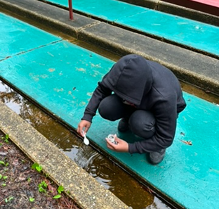
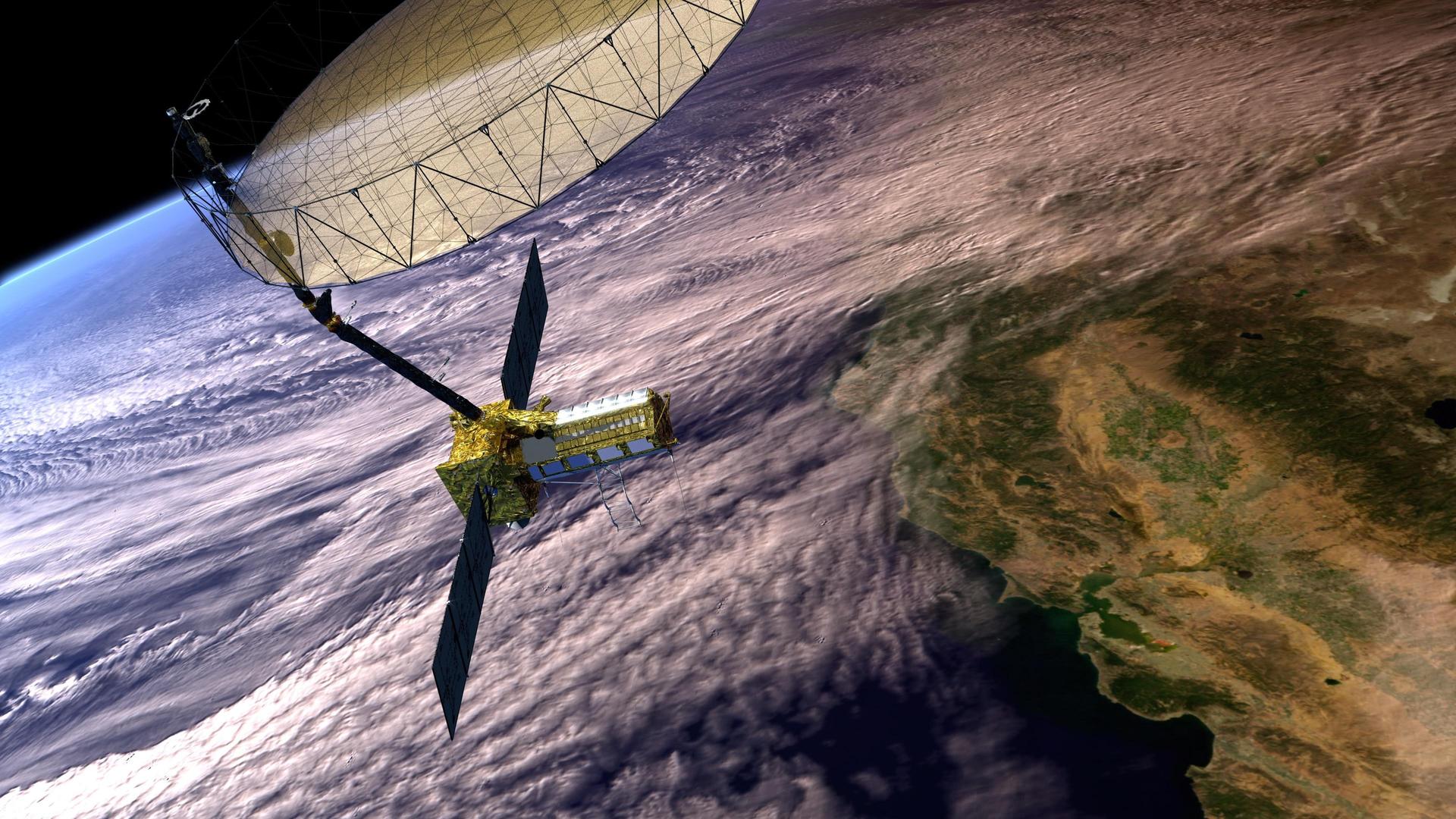
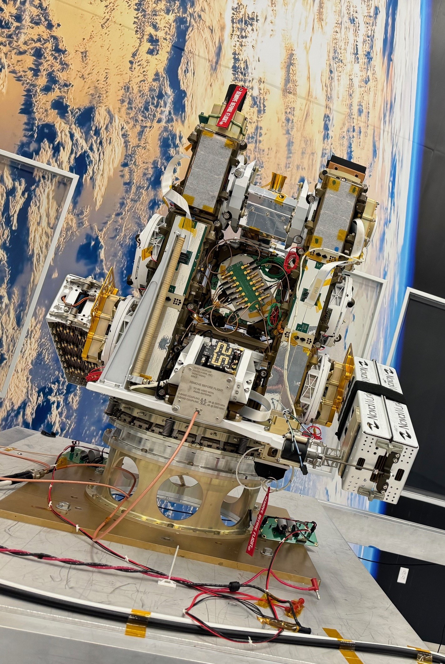
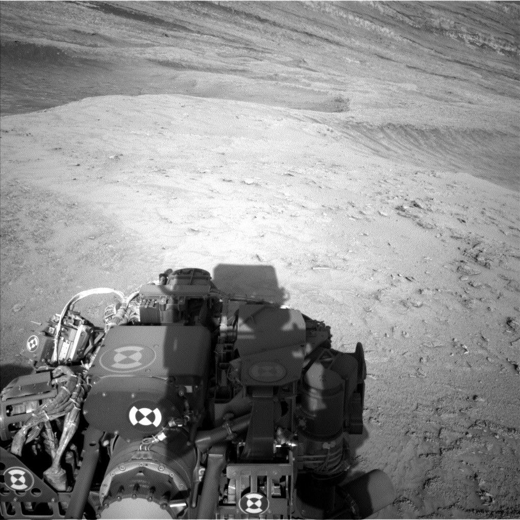