
NASA
NASA Releases Opportunity to Boost Commercial Space Tech Development
5 min read
Preparations for Next Moonwalk Simulations Underway (and Underwater) Credit: NASANASA has released a new proposal opportunity for industry to tap into agency know-how, resources, and expertise. The Announcement of Collaboration Opportunity (ACO), managed by the Space Technology Mission Directorate, enables valuable collaboration without financial exchanges between NASA and industry partners. Instead, companies leverage NASA subject matter experts, facilities, software, and hardware to accelerate their technologies and prepare them for future commercial and government use.
On Wednesday, NASA issued a standing ACO announcement for partnership proposals which will be available for five years and will serve as the umbrella opportunity for topic-specific appendix releases. NASA intends to issue appendices every six to 12 months to address evolving space technology needs. The 2025 ACO appendix is open for proposals until Sept. 24.
NASA will host an informational webinar about the opportunity and appendix at 2 p.m. EDT on Wednesday, Aug. 6. Interested proposers are encouraged to submit questions which will be answered during the webinar and will be available online after the webinar.
NASA teaming with industry isn’t new – decades of partnerships have resulted in ambitious missions that benefit all of humanity. But in recent years, NASA has also played a key role as a technology enabler, providing one-of-a-kind tools, resources, and infrastructure to help commercial aerospace companies achieve their goals.
Since 2015, NASA has collaborated with industry on approximately 80 ACO projects. Here are some ways the collaborations have advanced space technology:
Lunar lander systemsBlue Origin and NASA worked together on several ACOs to mature the company’s lunar lander design. NASA provided technical reports and assessments and conducted tests at multiple centers to help Blue Origin advance a stacked fuel cell system for a lander’s primary power source. Other Blue Origin ACO projects evaluated high-temperature engine materials and advanced a landing navigation and guidance system.
Blue Origin’s Blue Moon Mark 1 (MK1) lander is delivering NASA science and technology to the Moon through the agency’s Commercial Lunar Payload Services initiative. In 2023, NASA selected Blue Origin as a Human Landing System provider to develop its Blue Moon MK2 lander for future crewed lunar exploration.
Artist concept of Blue Origin’s Blue Moon Mark 1 (MK1) lander.Credit: Blue Origin Cryogenic fluid transferThroughout a year-long ACO, NASA and SpaceX engineers worked together to perform in-depth computational fluid analysis of proposed propellant transfer methods between two SpaceX Starship spacecraft in low-Earth orbit. The SpaceX-specific analysis utilized Starship flight data and data from previous NASA research and development to identify potential risks and help mitigate them during the early stages of commercial development. NASA also provided inputs as SpaceX developed an initial concept of operations for its orbital propellant transfer missions.
SpaceX used the ACO analyses to inform the design of its Starship Human Landing System, which NASA selected in 2021 to put the first Artemis astronauts on the Moon.
This artist’s concept depicts a SpaceX Starship tanker (bottom) transferring propellant to a Starship depot (top) in low Earth orbit. Before astronauts launch in Orion atop the agency’s SLS (Space Launch System) rocket, SpaceX will launch a storage depot to Earth orbit. For the Artemis III and Artemis IV missions, SpaceX plans to complete propellant loading operations in Earth orbit to send a fully fueled Starship Human Landing System (HLS) to the Moon.Credit: SpaceX Autonomous spacecraft navigation solutionAdvanced Space and NASA partnered to advance the company’s Cislunar Autonomous Positioning System – software that allows lunar spacecraft to determine their location without relying exclusively on tracking from Earth.
Dylan Schmidt, CAPSTONE assembly integration and test lead, installs solar panels onto the CAPSTONE spacecraft at Tyvak Nano-Satellite Systems, Inc., in Irvine, California.NASA/Dominic HartThe CAPSTONE (Cislunar Autonomous Positioning System Technology Operations and Navigation Experiment) spacecraft launched to the Moon in 2022 and continues to operate and collect critical data to refine the software. Under the ACO, Advanced Space was able to use NASA’s Lunar Reconnaissance Orbiter to conduct crosslink experiments with CAPSTONE, helping mature the navigation solution for future missions. The mission’s Cislunar Autonomous Positioning System technology was initially supported through the NASA Small Business Innovation Research program.
Multi-purpose laser sensing systemSensuron and NASA matured a miniature, rugged fiber optic sensing system capable of taking thermal and shape measurements for multiple applications. Throughout the ACO, Sensuron benefitted from NASA’s expertise in fiber optics and electrical, mechanical, and system testing engineering to design, fabricate, and “shake and bake” its prototype laser.
Sensuron Ruggedized Fiber Optics Sensing System.SensuronSpace missions could use the technology to monitor cryogenic propellant levels and determine a fuel tank’s structural integrity throughout an extended mission. The laser technology also has medical applications on Earth, which ultimately resulted in the Sensuron spinoff company, The Shape Sensing Company.
Flexible lunar tiresIn 2023, Venturi Astrolab began work with NASA under an ACO to test its flexible lunar tire design. The company tapped into testing capabilities unique to NASA, including heat transfer to cold lunar soil, traction, and life testing. The data validated the performance of tire prototypes, helping ready the design to support future NASA missions.
In 2024, NASA selected three companies, including Venturi Astrolab, to advance capabilities for a lunar terrain vehicle that astronauts could use to travel around the lunar surface, conducting scientific research on the Moon and preparing for human missions to Mars.
Venturi Lab designed and developed a durable, robust, and hyper-deformable lunar wheel.Venturi LabThe Announcement of Collaboration Opportunity (ACO) is one of many ways NASA enables commercial industry to develop, build, own, and eventually operate space systems. To learn more about these technology projects and more, visit: https://techport.nasa.gov/.
Facebook logo @NASATechnology @NASA_Technology Explore More 2 min read NASA Seeks Industry Concepts on Moon, Mars Communications Article 1 week ago 1 min read USBR Seal Team Fix Challenge Article 1 week ago 4 min read NASA Tests New Heat Source Fuel for Deep Space Exploration Article 1 week ago Share Details Last Updated Jul 31, 2025 EditorJennifer M. Dooren Related TermsNASA Tests Epic Solution for Supersonic Parachute Deliveries
2 min read
Preparations for Next Moonwalk Simulations Underway (and Underwater)NASA/Lori Losey
The best way to solve a mystery is by gathering evidence and building a case. That’s exactly what NASA researchers are doing with a series of research flights aimed at advancing a sensor for supersonic parachutes. The clues they find could help make these parachutes more reliable and safer for delivering scientific instruments and payloads to Mars.
These investigative research flights are led by the EPIC (Enhancing Parachutes by Instrumenting the Canopy) team at NASA’s Armstrong Fight Research Center in Edwards, California. During a June flight test, a quadrotor aircraft, or drone, air-launched a capsule that deployed a parachute equipped with a sensor. The flexible, strain-measuring sensor attached to the parachute did not interfere with the canopy material, just as the EPIC team had predicted. The sensors also provided data, a bonus for planning upcoming tests.
“Reviewing the research flights will help inform our next steps,” said Matt Kearns, project manager for EPIC at NASA Armstrong. “We are speaking with potential partners to come up with a framework to obtain the data that they are interested in pursuing. Our team members are developing methods for temperature testing the flexible sensors, data analysis, and looking into instrumentation for future tests.”
The flight tests were a first step toward filling gaps in computer models to improve supersonic parachutes. This work could also open the door to future partnerships, including with the aerospace and auto racing industries.
NASA’s Space Technology Mission Directorate (STMD) funds the EPIC work through its Entry Systems Modeling project at NASA’s Ames Research Center in California’s Silicon Valley. The capsule and parachute system were developed by NASA’s Langley Research Center in Hampton, Virginia. NASA Armstrong interns worked with Langley to build and integrate a similar system for testing at NASA Armstrong. An earlier phase of the work focused on finding commercially available flexible strain sensors and developing a bonding method as part of an STMD Early Career Initiative project.
NASA researchers Paul Bean, center, and Mark Hagiwara, right, attach the capsule with parachute system to the Enhancing Parachutes by Instrumenting the Canopy test experiment on June 4, 2025, at NASA’s Armstong Flight Research Center in Edwards, California. NASA researchers are developing technology to make supersonic parachutes safer and more reliable for delivering science instruments and payloads to Mars.NASA/Christopher LC Clark Derek Abramson, left, and Justin Link, right, attach an Alta X drone to the Enhancing Parachutes by Instrumenting the Canopy test experiment on June 4, 2025, at NASA’s Armstong Flight Research Center in Edwards, California. Abramson is NASA chief engineer at the center’s Dale Reed Subscale Flight Research Laboratory, where Link also works as a pilot for small uncrewed aircraft systems. NASA researchers are developing technology to make supersonic parachutes safer and more reliable for delivering science instruments and payloads to Mars.NASA/Christopher LC Clark An Alta X drone is positioned at altitude for an air launch of the Enhancing Parachutes by Instrumenting the Canopy test experiment on June 4, 2025, at NASA’s Armstong Flight Research Center in Edwards, California. NASA researchers are developing technology to make supersonic parachutes safer and more reliable for delivering science instruments and payloads to Mars.NASA/Christopher LC Clark The parachute of the Enhancing Parachutes by Instrumenting the Canopy test experiment deploys following an air launch from an Alta X drone on June 4, 2025, at NASA’s Armstong Flight Research Center in Edwards, California. NASA researchers are developing technology to make supersonic parachutes safer and more reliable for delivering science instruments and payloads to Mars.NASA/Christopher LC Clark The Enhancing Parachutes by Instrumenting the Canopy project team examines a capsule and parachute following an air launch from an Alta X drone on June 4, 2025, at NASA’s Armstong Flight Research Center in Edwards, California. NASA researchers are developing technology to make supersonic parachutes safer and more reliable for delivering science instruments and payloads to Mars.NASA/Christopher LC Clark Share Details Last Updated Jul 29, 2025 EditorDede DiniusContactJay Levinejay.levine-1@nasa.gov Related Terms Explore More 5 min read NASA Releases Opportunity to Boost Commercial Space Tech Development Article 1 day ago 3 min read NASA Drop Test Supports Safer Air Taxi Design and Certification Article 3 days ago 3 min read NASA Rehearses How to Measure X-59’s Noise Levels Article 6 days ago Keep Exploring Discover More Topics From NASAArmstrong Flight Research Center
Humans in Space
Climate Change
Solar System
NASA Tests Epic Solution for Supersonic Parachute Deliveries
2 min read
Preparations for Next Moonwalk Simulations Underway (and Underwater)NASA/Lori Losey
The best way to solve a mystery is by gathering evidence and building a case. That’s exactly what NASA researchers are doing with a series of research flights aimed at advancing a sensor for supersonic parachutes. The clues they find could help make these parachutes more reliable and safer for delivering scientific instruments and payloads to Mars.
These investigative research flights are led by the EPIC (Enhancing Parachutes by Instrumenting the Canopy) team at NASA’s Armstrong Fight Research Center in Edwards, California. During a June flight test, a quadrotor aircraft, or drone, air-launched a capsule that deployed a parachute equipped with a sensor. The flexible, strain-measuring sensor attached to the parachute did not interfere with the canopy material, just as the EPIC team had predicted. The sensors also provided data, a bonus for planning upcoming tests.
“Reviewing the research flights will help inform our next steps,” said Matt Kearns, project manager for EPIC at NASA Armstrong. “We are speaking with potential partners to come up with a framework to obtain the data that they are interested in pursuing. Our team members are developing methods for temperature testing the flexible sensors, data analysis, and looking into instrumentation for future tests.”
The flight tests were a first step toward filling gaps in computer models to improve supersonic parachutes. This work could also open the door to future partnerships, including with the aerospace and auto racing industries.
NASA’s Space Technology Mission Directorate (STMD) funds the EPIC work through its Entry Systems Modeling project at NASA’s Ames Research Center in California’s Silicon Valley. The capsule and parachute system were developed by NASA’s Langley Research Center in Hampton, Virginia. NASA Armstrong interns worked with Langley to build and integrate a similar system for testing at NASA Armstrong. An earlier phase of the work focused on finding commercially available flexible strain sensors and developing a bonding method as part of an STMD Early Career Initiative project.
NASA researchers Paul Bean, center, and Mark Hagiwara, right, attach the capsule with parachute system to the Enhancing Parachutes by Instrumenting the Canopy test experiment on June 4, 2025, at NASA’s Armstong Flight Research Center in Edwards, California. NASA researchers are developing technology to make supersonic parachutes safer and more reliable for delivering science instruments and payloads to Mars.NASA/Christopher LC Clark Derek Abramson, left, and Justin Link, right, attach an Alta X drone to the Enhancing Parachutes by Instrumenting the Canopy test experiment on June 4, 2025, at NASA’s Armstong Flight Research Center in Edwards, California. Abramson is NASA chief engineer at the center’s Dale Reed Subscale Flight Research Laboratory, where Link also works as a pilot for small uncrewed aircraft systems. NASA researchers are developing technology to make supersonic parachutes safer and more reliable for delivering science instruments and payloads to Mars.NASA/Christopher LC Clark An Alta X drone is positioned at altitude for an air launch of the Enhancing Parachutes by Instrumenting the Canopy test experiment on June 4, 2025, at NASA’s Armstong Flight Research Center in Edwards, California. NASA researchers are developing technology to make supersonic parachutes safer and more reliable for delivering science instruments and payloads to Mars.NASA/Christopher LC Clark The parachute of the Enhancing Parachutes by Instrumenting the Canopy test experiment deploys following an air launch from an Alta X drone on June 4, 2025, at NASA’s Armstong Flight Research Center in Edwards, California. NASA researchers are developing technology to make supersonic parachutes safer and more reliable for delivering science instruments and payloads to Mars.NASA/Christopher LC Clark The Enhancing Parachutes by Instrumenting the Canopy project team examines a capsule and parachute following an air launch from an Alta X drone on June 4, 2025, at NASA’s Armstong Flight Research Center in Edwards, California. NASA researchers are developing technology to make supersonic parachutes safer and more reliable for delivering science instruments and payloads to Mars.NASA/Christopher LC Clark Share Details Last Updated Jul 29, 2025 EditorDede DiniusContactJay Levinejay.levine-1@nasa.gov Related Terms Explore More 5 min read NASA Releases Opportunity to Boost Commercial Space Tech Development Article 1 day ago 3 min read NASA Drop Test Supports Safer Air Taxi Design and Certification Article 3 days ago 3 min read NASA Rehearses How to Measure X-59’s Noise Levels Article 6 days ago Keep Exploring Discover More Topics From NASAArmstrong Flight Research Center
Humans in Space
Climate Change
Solar System
NASA-ISRO Satellite Lifts Off to Track Earth’s Changing Surfaces
Editor’s Note: This release was edited on July 30, 2025, to correct the mission launch time in the IST time zone.
Carrying an advanced radar system that will produce a dynamic, three-dimensional view of Earth in unprecedented detail, the NISAR (NASA-ISRO Synthetic Aperture Radar) satellite has launched from Satish Dhawan Space Centre in Sriharikota, Andhra Pradesh, India.
Jointly developed by NASA and the Indian Space Research Organisation (ISRO), and a critical part of the United States – India civil-space cooperation highlighted by President Trump and Prime Minister Modi earlier this year, the satellite can detect the movement of land and ice surfaces down to the centimeter. The mission will help protect communities by providing unique, actionable information to decision-makers in a diverse range of areas, including disaster response, infrastructure monitoring, and agricultural management.
The satellite lifted off aboard an ISRO Geosynchronous Satellite Launch Vehicle (GSLV) rocket at 5:40 p.m. IST (8:10 a.m. EDT), Wednesday. The ISRO ground controllers began communicating with NISAR about 20 minutes after launch, at just after 8:29 a.m. EDT, and confirmed it is operating as expected.
“Congratulations to the entire NISAR mission team on a successful launch that spanned across multiple time zones and continents in the first-ever partnership between NASA and ISRO on a mission of this sheer magnitude,” said Nicky Fox, associate administrator, Science Mission Directorate at NASA Headquarters in Washington. “Where moments are most critical, NISAR’s data will help ensure the health and safety of those impacted on Earth, as well as the infrastructure that supports them, for the benefit of all.”
From 464 miles (747 kilometers) above Earth, NISAR will use two advanced radar instruments to track changes in Earth’s forests and wetland ecosystems, monitor deformation and motion of the planet’s frozen surfaces, and detect the movement of Earth’s crust down to fractions of an inch — a key measurement in understanding how the land surface moves before, during, and after earthquakes, volcanic eruptions, and landslides.
“ISRO’s GSLV has precisely injected NISAR satellite into the intended orbit, 747 kilometers. I am happy to inform that this is GSLV’s first mission to Sun-synchronous polar orbit. With this successful launch, we are at the threshold of fulfilling the immense scientific potential NASA and ISRO envisioned for the NISAR mission more than 10 years ago,” said ISRO Chairman V Narayanan. “The powerful capability of this radar mission will help us study Earth’s dynamic land and ice surfaces in greater detail than ever before.”
The mission’s two radars will monitor nearly all the planet’s land- and ice-covered surfaces twice every 12 days, including areas of the polar Southern Hemisphere rarely covered by other Earth-observing radar satellites. The data NISAR collects also can help researchers assess how forests, wetlands, agricultural areas, and permafrost change over time.
“Observations from NISAR will provide new knowledge and tangible benefits for communities both in the U.S. and around the world,” said Karen St. Germain, director, Earth Science division at NASA Headquarters. “This launch marks the beginning of a new way of seeing the surface of our planet so that we can understand and foresee natural disasters and other changes in our Earth system that affect lives and property.”
The NISAR satellite is the first free-flying space mission to feature two radar instruments — an L-band system and an S-band system. Each system is sensitive to features of different sizes and specializes in detecting certain attributes. The L-band radar excels at measuring soil moisture, forest biomass, and motion of land and ice surfaces, while S-band radar excels at monitoring agriculture, grassland ecosystems, and infrastructure movement.
Together, the radar instruments will enhance all of the satellite’s observations, making NISAR more capable than previous synthetic aperture radar missions. Unlike optical sensors, NISAR will be able to “see” through clouds, making it possible to monitor the surface during storms, as well as in darkness and light.
NASA’s Jet Propulsion Laboratory in Southern California provided the L-band radar, and ISRO’s Space Applications Centre in Ahmedabad developed the S-band radar. The NISAR mission marks the first time the two agencies have co-developed hardware for an Earth-observing mission.
“We’re proud of the international team behind this remarkable satellite. The mission’s measurements will be global but its applications deeply local, as people everywhere will use its data to plan for a resilient future,” said Dave Gallagher, director, NASA JPL, which manages the U.S. portion of the mission for NASA. “At its core is synthetic aperture radar, a technology pioneered at NASA JPL that enables us to study Earth night and day, through all kinds of weather.”
Including L-band and S-band radars on one satellite is an evolution in SAR airborne and space-based missions that, for NASA, started in 1978 with the launch of Seasat. In 2012, ISRO began launching SAR missions starting with Radar Imaging Satellite (RISAT-1), followed by RISAT-1A in 2022, to support a wide range of applications in India.
In the coming weeks, the spacecraft will begin a roughly 90-day commissioning phase during which it will deploy its 39-foot (12-meter) radar antenna reflector. This reflector will direct and receive microwave signals from the two radars. By interpreting the differences between the two, researchers can discern characteristics about the surface below. As NISAR passes over the same locations twice every 12 days, scientists can evaluate how those characteristics have changed over time to reveal new insights about Earth’s dynamic surfaces.
The NISAR mission is an equal collaboration between NASA and ISRO. Managed for the agency by Caltech, NASA JPL leads the U.S. component of the project and is providing the mission’s L-band SAR. NASA also is providing the radar reflector antenna, the deployable boom, a high-rate communication subsystem for science data, GPS receivers, a solid-state recorder, and payload data subsystem.
Space Applications Centre Ahmedabad, ISRO’s lead center for payload development, is providing the mission’s S-band SAR instrument and is responsible for its calibration, data processing, and development of science algorithms to address the scientific goals of the mission. U R Rao Satellite Centre in Bengaluru, which leads the ISRO components of the mission, is providing the spacecraft bus. The launch vehicle is from ISRO’s Vikram Sarabhai Space Centre, launch services are through ISRO’s Satish Dhawan Space Centre, and satellite operations are by ISRO Telemetry Tracking and Command Network. National Remote Sensing Centre in Hyderabad is responsible for S-band data reception, operational products generation, and dissemination.
To learn more about NISAR, visit:
-end-
Karen Fox / Elizabeth Vlock
Headquarters, Washington
202-358-1600
karen.c.fox@nasa.gov / elizabeth.a.vlock@nasa.gov
Andrew Wang / Jane J. Lee
Jet Propulsion Laboratory, Pasadena, Calif.
626-379-6874 / 818-354-0307
andrew.wang@jpl.nasa.gov / jane.j.lee@jpl.nasa.gov
NASA’s Webb Traces Details of Complex Planetary Nebula
- Webb
- News
- Overview
- Science
- Observatory
- Multimedia
- Team
- More
NASA, ESA, CSA, STScI
Since their discovery in the late 1700s, astronomers have learned that planetary nebulae, or the expanding shell of glowing gas expelled by a low-intermediate mass star late in its life, can come in all shapes and sizes. Most planetary nebula present as circular, elliptical, or bi-polar, but some stray from the norm, as seen in new high-resolution images of planetary nebulae by NASA’s James Webb Space Telescope.
Webb’s newest look at planetary nebula NGC 6072 in the near- and mid-infrared shows what may appear as a very messy scene resembling splattered paint. However, the unusual, asymmetrical appearance hints at more complicated mechanisms underway, as the star central to the scene approaches the very final stages of its life and expels shells of material, losing up to 80 percent of its mass. Astronomers are using Webb to study planetary nebulae to learn more about the full life cycle of stars and how they impact their surrounding environments.
Image A: NGC 6072 (NIRCam Image) NASA’s James Webb Space Telescope’s view of planetary nebula NGC 6072 in the near-infrared shows a complex scene of multiple outflows expanding out at different angles from a dying star at the center of the scene. In this image, the red areas represent cool molecular gas, for example, molecular hydrogen. NASA, ESA, CSA, STScIFirst, taking a look at the image from Webb’s NIRCam (Near-Infrared Camera), it’s readily apparent that this nebula is multi-polar. This means there are several different elliptical outflows jetting out either way from the center, one from 11 o’clock to 5 o’clock, another from 1 o’clock to 7 o’clock, and possibly a third from 12 o’clock to 6 o’clock. The outflows may compress material as they go, resulting in a disk seen perpendicular to it.
Astronomers say this is evidence that there are likely at least two stars at the center of this scene. Specifically, a companion star is interacting with an aging star that had already begun to shed some of its outer layers of gas and dust.
The central region of the planetary nebula glows from the hot stellar core, seen as a light blue hue in near-infrared light. The dark orange material, which is made up of gas and dust, follows pockets or open areas that appear dark blue. This clumpiness could be created when dense molecular clouds formed while being shielded from hot radiation from the central star. There could also be a time element at play. Over thousands of years, inner fast winds could be ploughing through the halo cast off from the main star when it first started to lose mass.
Image B: NGC 6072 (MIRI Image) The mid-infrared view of planetary nebula NGC 6072 from NASA’s James Webb Space Telescope show expanding circular shells around the outflows from the dying central star. In this image, the blue represents cool molecular gas seen in red in the image from Webb’s NIRCam (Near-Infrared Camera) due to color mapping. NASA, ESA, CSA, STScIThe longer wavelengths captured by Webb’s MIRI (Mid-Infrared Instrument) are highlighting dust, revealing the star researchers suspect could be central to this scene. It appears as a small pinkish-whitish dot in this image.
Webb’s look in the mid-infrared wavelengths also reveals concentric rings expanding from the central region, the most obvious circling just past the edges of the lobes.
This may be additional evidence of a secondary star at the center of the scene hidden from our view. The secondary star, as it circles repeatedly around the original star, could have carved out rings of material in a bullseye pattern as the main star was expelling mass during an earlier stage of its life.
The rings may also hint at some kind of pulsation that resulted in gas or dust being expelled uniformly in all directions separated by say, thousands of years.
The red areas in NIRCam and blue areas in MIRI both trace cool molecular gas (likely molecular hydrogen) while central regions trace hot ionized gas.
As the star at the center of a planetary nebula cools and fades, the nebula will gradually dissipate into the interstellar medium — contributing enriched material that helps form new stars and planetary systems, now containing those heavier elements.
Webb’s imaging of NGC 6072 opens the door to studying how the planetary nebulae with more complex shapes contribute to this process.
The James Webb Space Telescope is the world’s premier space science observatory. Webb is solving mysteries in our solar system, looking beyond to distant worlds around other stars, and probing the mysterious structures and origins of our universe and our place in it. Webb is an international program led by NASA with its partners, ESA (European Space Agency) and CSA (Canadian Space Agency).
To learn more about Webb, visit:
DownloadsView/Download all image products at all resolutions for this article from the Space Telescope Science Institute.
Media ContactsLaura Betz – laura.e.betz@nasa.gov
NASA’s Goddard Space Flight Center, Greenbelt, Md.
Hannah Braun – hbraun@stsci.edu
Space Telescope Science Institute, Baltimore, Md.
View more Webb planetary nebula images
Learn more about planetary nebula
Interactive: Explore the Helix Nebula planetary nebula
Watch ViewSpace videos about planetary nebulas
Related For Kids En Español Keep Exploring Related Topics James Webb Space TelescopeWebb is the premier observatory of the next decade, serving thousands of astronomers worldwide. It studies every phase in the…
Stars
Stars Stories
Universe
Share Details Last Updated Jul 30, 2025 Editor Marty McCoy Contact Laura Betz laura.e.betz@nasa.gov Related Terms
Looking Forward to the Moon
Looking Forward to the Moon
On May 8, 2022, NASA’s Exploration Ground Systems’ Program Manager Shawn Quinn captured this crop of a full frame image of the Hadley–Apennine region of Earth’s Moon including the Apollo 15 landing site (very near the edge of the shadow of one of the lunar mountains in the area). Building upon the pioneers from the Apollo Program, Artemis crews will plan to verify capabilities for humans to explore deep space and pave the way for long-term exploration and science on the lunar surface.
Read the Artemis blog for the latest mission updates.
Image credit: NASA/Shawn Quinn
Laine Havens: Melding Science and Storytelling
Laine Havens — now a senior at Cornell University and three-time NASA intern — grew up with a deep curiosity about how the universe works and a family that encouraged her to explore it. Throughout her childhood, Laine was immersed in science and exposed to wonderful science communicators by her mother and grandfather.
Her grandfather, a retired Kodak engineer, encouraged inquisition into all matters — whether it be the inner workings of a telescope or an abandoned hornet’s nest. Laine spent summer evenings watching Mythbusters or Cosmos, and her mother’s favorite science podcast soundtracked car trips. Inspired by the likes of Carl Sagan, Laine originally intended to become a scientist.
“I fell in love with physics in high school,” she says. “I figured I would study it in college all the way through to a Ph.D.”
As a three-time NASA communications intern, Laine Havens has translated science for an audience of millions of people around the globe through science writing, social media, and video production.Credit: Kristin Rutkowski PhotographyLaine enrolled at Cornell and originally majored in physics as planned. But then she discovered an even more exciting option serendipitously while browsing an academic catalog: science and technology studies.
“I was scrolling through looking for a different class, but then I saw science and technology studies and began reading more about what it involved,” Laine says. “It was all about studying science — the philosophy of what it is, and how it interacts with social, political, ethical, and historical dimensions.”
Seeing the new program made Laine realize she could connect her love for critical analysis with her interest in science. She changed her program to a double-major in science and technology studies and astronomy, resolving to not only study and communicate science but to better understand the factors that influence it.
Laine (left) is a senior at Cornell University, where she double-majors in astronomy and science and technology studies. She served as the student newspaper’s science editor and president of the Pants Improv Comedy group. Laine channeled her comedic skills for some of her NASA projects, including a reel that used puns to discuss the agency’s upcoming Nancy Grace Roman Space Telescope.Credit: Courtesy of Laine HavensLaine began by working as a science writer at her university’s student-run newspaper, The Cornell Daily Sun, where she later became the science editor. Meanwhile, she volunteered with The Physics Bus — basically a mini science museum on wheels with experiments for kids — and the Free Science Workshop, an after school program offering kids an opportunity to build things or craft using all sorts of materials and gadgets.
“When you first hear about physics there’s a huge stigma, so we aimed to expose kids to it at a young age so they would associate it with fun,” Laine says.
Laine volunteered with The Physics Bus to introduce kids to the subject in a fun environment, helping them see the magic of how the world works before they learn to associate physics with boredom or intimidation.Credit: Courtesy of Laine HavensDuring her junior year, Laine started searching for science communication internships and found one at NASA’s Goddard Space Flight Center in Greenbelt, Maryland. She applied and was accepted to one focusing on NASA’s upcoming Nancy Grace Roman Space Telescope. Following her first internship, Laine came back for two more with the same team.
“Every day here at NASA is inspiring,” Laine says. “I’ve learned so much about both hard and soft skills involved in science communication.”
During her first internship, Laine leaned into her background as a science writer to cover engineering milestones and craft a Tumblr post that walks readers through the universe’s different stages. She also produced videos, including one about Goddard’s biggest clean room.
“Everybody let me take that and run,” Laine says. “I got to write the script, host the video, and edit it.” The video, which garnered millions of views on social media, was the first of several Laine created to engage NASA’s traditional audience while drawing in others who don’t typically follow NASA or science very closely.
In addition to her usual assigned tasks, Laine took opportunities to be involved in many different aspects of science storytelling. This photo was taken while Laine worked as a drone spotter, helping to ensure a camera-equipped drone wouldn’t damage sensitive space hardware.Credit: NASA/Sophia RobertsThroughout her internships, Laine also led tours to teach people more about Roman, helped manage a celebrity visit with John Rhys-Davies, wrote Roman team member profiles, helped gather drone footage, contributed to the release of the NASA documentary Cosmic Dawn, emceed an intern day event, and supported Live Shots — short, live TV interviews with NASA experts.
“It’s been cool to see a different side of things,” Laine says. “I ultimately want to keep doing what I’ve been doing, but also become engaged in how to make it better — the science of science communication.”
To others who are interested in interning at NASA, Laine recommends speaking up.
“Just ask people things, whether it’s for help or an opportunity,” she says. “Sometimes you don’t want to impose or risk looking dumb, but for the most part everyone wants to help you and see you succeed. I’m very grateful to the Roman team for making it feel like a safe space where I could speak up.”
In preparation for a clean room “Get Ready With Me” video, Laine shadowed NASA videographer Sophia Roberts in the clean room at the agency’s Goddard Space Flight Center, where she supported documentation of integration milestones for NASA’s Nancy Grace Roman Space Telescope. Credit: NASA/Sophia RobertsSometimes that meant pitching ideas that were ultimately rejected, but that still provided an opportunity for discussion. “Not everything works, but in talking about it you might think of something else that does work,” she says. “There’s no consequence to it, because either way you’re learning something from it — either from the process of seeing it through or figuring out why you can’t do it.”
The same advice applies to securing an internship in the first place.
“Don’t be afraid to advocate for yourself,” Laine says. “If you find something you love, you can’t wait for it to happen on its own — you have to decide to go for it and find a way to make it happen.”
By Ashley Balzer
NASA’s Goddard Space Flight Center, Greenbelt, Md.
Curiosity Blog, Sols 4614-4615: Driving Along the Boxwork
- Curiosity Home
- Science
- News and Features
- Multimedia
- Mars Missions
- Mars Home
2 min read
Curiosity Blog, Sols 4614-4615: Driving Along the Boxwork NASA’s Mars rover Curiosity acquired this image, looking out in the direction from where it came, with the rover’s tracks visible through the dust and sand covering the ground. Curiosity acquired this image using its Left Navigation Camera on July 28, 2025 — Sol 4612, or Martian day 4,612 of the Mars Science Laboratory mission — at 00:27:23 UTC. NASA/JPL-CaltechWritten by Conor Hayes, Graduate Student at York University
Earth planning date: Monday, July 28, 2025
Today was a pretty straightforward day of planning. Our drive over the weekend completed successfully, and we quickly confirmed that we are parked in a stable position. Thus, we were able to unstow the rover’s arm to poke around in our new workspace, which features a large sand-filled fracture. Aside from all of the good geology work to be done, the view from our current location is quite spectacular.
We’re still in the time of year where the atmosphere at Gale is reasonably dust-free (at least, compared to later in the year), allowing us to look all the way out to and beyond the Gale crater rim. The upper slopes of Mount Sharp have also re-emerged to our east after spending months hidden behind the walls of Gediz Vallis. There’s a bit more sand and dust in this location than we’ve seen recently, so we can also see the trail left behind by the rover’s wheels as we drove to this location (see the image above).
We’re still deep in our examination of the boxwork structures that we’re now driving through, so most of Curiosity’s attention in this plan is focused much closer to the rover than any of the scenic vista surrounding us. APXS, DRT, and MAHLI will all take a look at “Cañón de Palca,” some bedrock close to the large fracture in this workspace. Mastcam and ChemCam RMI will image some boxwork ridges at “Caine,” and will also collaborate on imaging of the weekend’s post-drive AEGIS target and a LIBS bedrock target “Doña Ines.” Mastcam’s solo activities include taking a look at some layering at “Paniri butte” and at MAHLI to examine a speck of dust that may have fallen on the lens.
We’ll be driving away from this location along one of the boxwork ridges, which, at about 5 meters (about 16 feet) wide, is more than large enough to fit our car-sized rover. Post-drive activities are largely focused on environmental monitoring, including Navcam line-of-sight and dust-devil surveys to look at dust, and several Navcam cloud movies. As usual, ChemCam will also join the post-drive fun with an AEGIS observation. More environmental monitoring by REMS, RAD, and DAN fill out the remainder of this plan.
Learn more about Curiosity’s science instruments
For more Curiosity blog posts, visit MSL Mission Updates
Share Details Last Updated Jul 29, 2025 Related Terms Explore More 3 min read Spheres in the Sand
Article
3 hours ago
2 min read Curiosity Blog, Sols 4611-4613: Scenic Overlook
Article
1 day ago
3 min read Curiosity Blog, Sols 4609–4610: Recharged and Ready To Roll Onwards
Article
1 day ago
Keep Exploring Discover More Topics From NASA Mars
Mars is the fourth planet from the Sun, and the seventh largest. It’s the only planet we know of inhabited…
All Mars Resources
Explore this collection of Mars images, videos, resources, PDFs, and toolkits. Discover valuable content designed to inform, educate, and inspire,…
Rover Basics
Each robotic explorer sent to the Red Planet has its own unique capabilities driven by science. Many attributes of a…
Mars Exploration: Science Goals
The key to understanding the past, present or future potential for life on Mars can be found in NASA’s four…
Spheres in the Sand
- Perseverance Home
- Science
- News and Features
- Multimedia
- Mars Missions
- Mars Home
3 min read
Spheres in the Sand NASA’s Perseverance rover captured this image of spherule-bearing regolith at Rowsell Hill using its arm-mounted WATSON camera on July 5, 2025 — Sol 1555, or Martian day 1,555 of the Mars 2020 mission — at the local mean solar time of 12:46:29. WATSON (Wide Angle Topographic Sensor for Operations and eNgineering) is a close-range color camera that works with the rover’s SHERLOC instrument (Scanning Habitable Environments with Raman and Luminescence for Organics and Chemicals); both are located on the turret at the end of the rover’s robotic arm. NASA/JPL-CaltechWritten by Andrew Shumway, Postdoctoral Researcher at the University of Washington
It is not common for a rover to spot nearly perfect spheres in the soil beneath its wheels. Over two decades ago, the Opportunity rover famously discovered spherules made of hematite (nicknamed “blueberries”) near its landing site in Meridiani Planum. More recently, the Perseverance rover has similarly encountered spherules embedded in bedrock and loosely scattered throughout the region informally called “Witch Hazel Hill.” In a previous blog post, we described Perseverance’s investigations of a spherule-bearing outcrop at the “Hare Bay” abrasion patch, where the team later collected a core. With the “Bell Island” sample added to the rover’s collection, the science team next decided to take a closer look at loose spherules in the area, which appear to have eroded out of the nearby bedrock.
On Sol 1555, while the United States was celebrating the Fourth of July with hotdogs and fireworks, Perseverance was hard at work studying spherule-rich regolith at the target “Rowsell Hill” using the proximity instruments on its robotic arm. SHERLOC’s Autofocus and Context Imager and WATSON camera both captured high resolution pictures of the target (shown above), while PIXL measured the elemental makeup of the spherules and surrounding grains.
Despite their superficial similarity to Opportunity’s “blueberries”, the spherules at “Rowsell Hill” have a very different composition and likely origin. In Meridiani Planum, the spherules were composed of the mineral hematite and were interpreted to have formed in groundwater-saturated sediments in Mars’ distant past. By comparison, the spherules in “Rowsell Hill” have a basaltic composition and likely formed during a meteoroid impact or volcanic eruption. When a meteoroid crashes into the surface of Mars, it can melt rock and send molten droplets spraying into the air. Those droplets can then rapidly cool, solidifying into spherules that rain down on the surrounding area. Alternatively, the spherules may have formed from molten lava during a volcanic eruption.
With these new data in hand, the Perseverance science team continues to search for answers about where these spherules came from. If they formed during an ancient impact, they may be able to tell us about the composition of the meteoroid and the importance of impact cratering in early Mars’s history. If they instead formed during a volcanic eruption, they could preserve clues about past volcanism in the region around Jezero crater. Either way, these spherules are a remnant of an energetic and dynamic period in Mars’ history!
Learn more about Perseverance’s science instruments
For more Perseverance blog posts, visit Mars 2020 Mission Updates
Share Details Last Updated Jul 29, 2025 Related Terms Explore More 2 min read Curiosity Blog, Sols 4611-4613: Scenic Overlook
Article
1 day ago
3 min read Curiosity Blog, Sols 4609–4610: Recharged and Ready To Roll Onwards
Article
1 day ago
2 min read Feeling the Heat: Perseverance Looks for Evidence of Contact Metamorphism
Article
7 days ago
Keep Exploring Discover More Topics From NASA Mars
Mars is the fourth planet from the Sun, and the seventh largest. It’s the only planet we know of inhabited…
All Mars Resources
Explore this collection of Mars images, videos, resources, PDFs, and toolkits. Discover valuable content designed to inform, educate, and inspire,…
Rover Basics
Each robotic explorer sent to the Red Planet has its own unique capabilities driven by science. Many attributes of a…
Mars Exploration: Science Goals
The key to understanding the past, present or future potential for life on Mars can be found in NASA’s four…
NASA Selects Firefly for New Artemis Science, Tech Delivery to Moon
NASA has awarded Firefly Aerospace of Cedar Park, Texas, $176.7 million to deliver two rovers and three scientific instruments to the lunar surface as part of the agency’s CLPS (Commercial Lunar Payload Services) initiative and Artemis campaign to explore more of the Moon than ever before.
This delivery is the first time NASA will use multiple rovers and a variety of stationary instruments, in a collaborative effort with the CSA (Canadian Space Agency) and the University of Bern, to help us understand the chemical composition of the lunar South Pole region and discover the potential for using resources available in permanently shadowed regions of the Moon.
“Through CLPS, NASA is embracing a new era of lunar exploration, with commercial companies leading the way,” said Joel Kearns, deputy associate administrator for exploration, Science Mission Directorate, NASA Headquarters in Washington. “These investigations will produce critical knowledge required for long-term sustainability and contribute to a deeper understanding of the lunar surface, allowing us to meet our scientific and exploration goals for the South Pole region of the Moon for the benefit of all.”
Under the new CLPS task order, Firefly is tasked with delivering end-to-end payload services to the lunar surface, with a period of performance from Tuesday to March 29, 2030. The company’s lunar lander is targeted to land at the Moon’s South Pole region in 2029.
This is Firefly’s fifth task order award and fourth lunar mission through CLPS. Firefly’s first delivery successfully landed on the Moon’s near side in March 2025 with 10 NASA payloads. The company’s second mission, targeting a launch in 2026, includes a lunar orbit drop-off of a satellite combined with a delivery to the lunar surface on the far side. Firefly’s third lunar mission will target landing in the Gruithuisen Domes on the near side of the Moon in 2028, delivering six experiments to study that enigmatic lunar volcanic terrain.
“As NASA sends both humans and robots to further explore the Moon, CLPS deliveries to the lunar South Pole region will provide a better understanding of the exploration environment, accelerating progress toward establishing a long-term human presence on the Moon, as well as eventual human missions to Mars,” said Adam Schlesinger, manager of the CLPS initiative at NASA’s Johnson Space Center in Houston.
The rovers and instruments that are part of this newly awarded flight include:
- MoonRanger is an autonomous microrover that will explore the lunar surface. MoonRanger will collect images and telemetry data while demonstrating autonomous capabilities for lunar polar exploration. Its onboard Neutron Spectrometer System instrument will study hydrogen-bearing volatiles and the composition of lunar regolith, or soil.
Lead development organizations: NASA’s Ames Research Center in California’s Silicon Valley, and Carnegie Mellon University and Astrobotic, both in Pittsburgh. - Stereo Cameras for Lunar Plume Surface Studies will use enhanced stereo imaging photogrammetry, active illumination, and ejecta impact detection sensors to capture the impact of the rocket exhaust plume on lunar regolith as the lander descends on the Moon’s surface. The high-resolution stereo images will help predict lunar regolith erosion and ejecta characteristics, as bigger, heavier spacecraft and hardware are delivered to the Moon near each other in the future.
Lead development organization: NASA’s Langley Research Center in Hampton, Virginia. - Laser Retroreflector Array is an array of eight retroreflectors on an aluminum support structure that enables precision laser ranging, a measurement of the distance between the orbiting or landing spacecraft to the reflector on the lander. The array is a passive optical instrument, which functions without power, and will serve as a permanent location marker on the Moon for decades to come.
Lead development organization: NASA’s Goddard Space Flight Center in Greenbelt, Maryland. - A CSA Rover is designed to access and explore remote South Pole areas of interest, including permanently shadowed regions, and to survive at least one lunar night. The CSA rover has stereo cameras, a neutron spectrometer, two imagers (visible to near-infrared), a radiation micro-dosimeter, and a NASA-contributed thermal imaging radiometer developed by the Applied Physics Laboratory. These instruments will advance our understanding of the physical and chemical properties of the lunar surface, the geological history of the Moon, and potential resources such as water ice. It will also improve our understanding of the environmental challenges that await future astronauts and their life support systems.
Lead development organization: CSA. - Laser Ionization Mass Spectrometer is a mass spectrometer that will analyze the element and isotope composition of lunar regolith. The instrument will utilize a Firefly-built robotic arm and Titanium shovel that will deploy to the lunar surface and support regolith excavation. The system will then funnel the sample into its collection unit and use a pulsed laser beam to identify differences in chemistry compared to samples studied in the past, like those collected during the Apollo program. Grain-by-grain analyses will provide a better understanding of the chemical complexity of the landing site and the surrounding area, offering insights into the evolution of the Moon.
Lead development organization: University of Bern in Switzerland.
Through the CLPS initiative, NASA purchases lunar landing and surface operations services from American companies. The agency uses CLPS to send scientific instruments and technology demonstrations to advance capabilities for science, exploration, or commercial development of the Moon, and to support human exploration beyond to Mars. By supporting a robust cadence of lunar deliveries, NASA will continue to enable a growing lunar economy while leveraging the entrepreneurial innovation of the commercial space industry.
To learn more about CLPS and Artemis, visit:
-end-
Alise Fisher
Headquarters, Washington
202-358-2546
alise.m.fisher@nasa.gov
Nilufar Ramji
Johnson Space Center, Houston
281-483-5111
nilufar.ramji@nasa.gov
Adam and Hirsa Present Research on the Ring-Sheared Drop
3 min read
Adam and Hirsa Present Research on the Ring-Sheared Drop Abnormal fibrous, extracellular, proteinaceous deposits found in organs and tissues are associated with neurodegenerative diseases such as Alzheimer’s. (“Amyloid fibril formation in microgravity: Distinguishing interfacial and flow effects” NNX13AQ22G). The Ring Sheared Drop investigation studies the biophysics of protein amyloidogenesis in the absence of gravity in order to study fibril formation at fluid interfaces, in the absence of solid walls. NASAResearchers across Space Biology and Physical Sciences come together for a special presentation at the May PSI Users Group.
The Ring-Sheared Drop (RSD) is a Microgravity Science Glovebox experiment that launched in July 2019 to the ISS to study shearing flow in the absence of solid walls. The major goals of this project were to adapt and use the RSD module to develop and test predictive models of non-Newtonian flow of high-concentration proteins at the interface.
At the May Physical Sciences Informatics (PSI) User Group, Dr. Joe Adam, Research Scientist at Rensselaer Polytechnic Institute and University Payload Director of the RSD module, presented, “Protein Solution Hydrodynamic Studies in the Ring-Sheared Drop” detailing the history of RSD, research campaigns and data to be released in PSI. This investigation was led by Principal Investigator, Prof. Amir Hirsa of Rensselaer Polytechnic Institute.
The ring-sheared drop interfacial bioprocessing of pharmaceuticals-I (RSD-IBP-I) campaign aimed to study non-Newtonian interfacial hydrodynamics of the blood transport proteins bovine serum albumin (BSA) and human serum albumin (HSA) in microgravity. Specifically, scientific aims focus on the effects of protein primary structure (BSA or HSA), protein concentration and interfacial shear rate on microgravity fluid flow, measured using velocimetry of hollow glass microsphere tracer particles within protein samples. This campaign intended to confer improved understanding of interfacial protein flows in relation to physiology, the environment, and industry relevant to both spaceflight and Earth. Results from this line of research could have applications to in situ pharmaceutical production, tissue engineering, and diseases such as Alzheimer’s, Parkinson’s, infectious prions, and type 2 diabetes.
To encourage collaboration across common areas of BPS’s Physical Sciences and Biology research, PSI invited Ryan Scott, ALSDA lead Scientist, and members of the ADBR (Alz Disease & Brain Resilience) and Parkinson’s AWG subgroups to attendee this month’s meeting which fueled discussions and led to several connections. During the discussions the two relevant collaborative publications that were shared are:
- McMackin, P., Adam, J., Griffin, S. et al. Amyloidogenesis via interfacial shear in a containerless biochemical reactor aboard the International Space Station. npj Microgravity 8, 41 (2022). https://doi.org/10.1038/s41526-022-00227-2
- Nilufar Ali paper resulting in part from a collaboration within the Parkison’s AWG subgroup
Ali, N., Beheshti, A. & Hampikian, G. Space exploration and risk of Parkinson’s disease: a perspective review. npj Microgravity 11, 1 (2025). https://doi.org/10.1038/s41526-024-00457-6
Ring-Sheared Drop – Interfacial Bioprocessing of Pharmaceuticals(RSD-IBP-I) is now accessible in PSI. http://doi.org/10.60555/smat-bb74
Share Details Last Updated Jul 29, 2025 Related Terms Explore More 1 min read 2025 NASA Space Apps ChallengeArticle
1 day ago
2 min read OSDR Chats with Begum Mathyk
Article
1 day ago
4 min read Helio Highlights: June 2025
Article
2 weeks ago
Keep Exploring Discover Related Topics
Missions
Humans in Space
Climate Change
Solar System

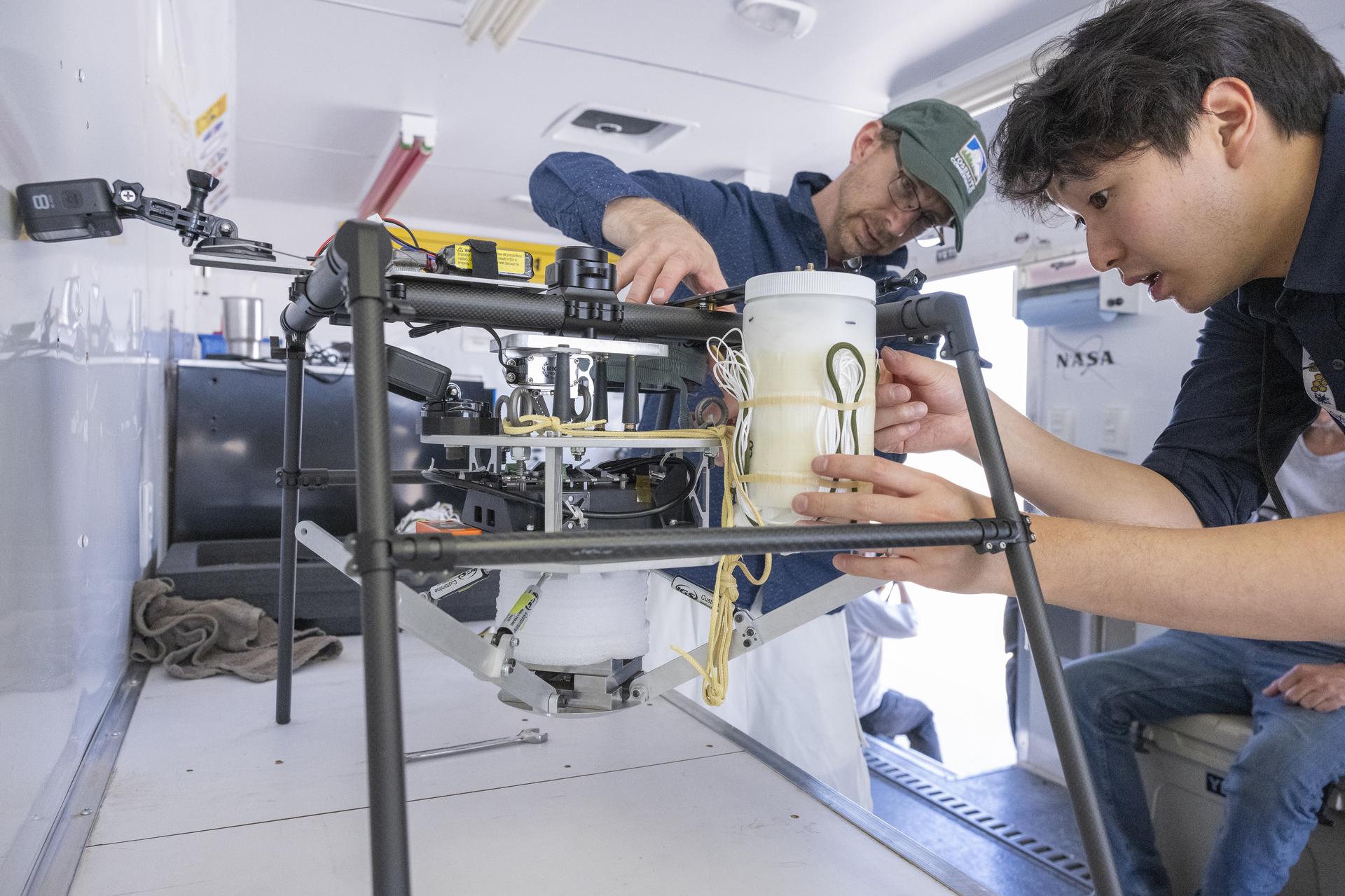
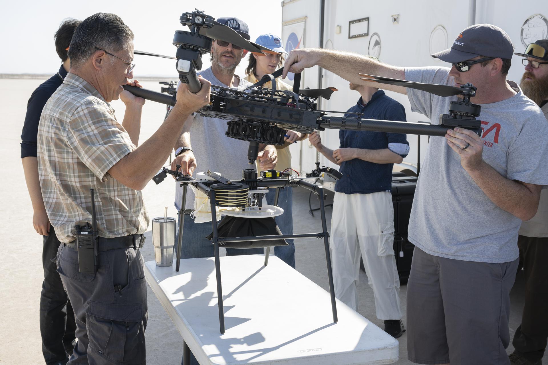
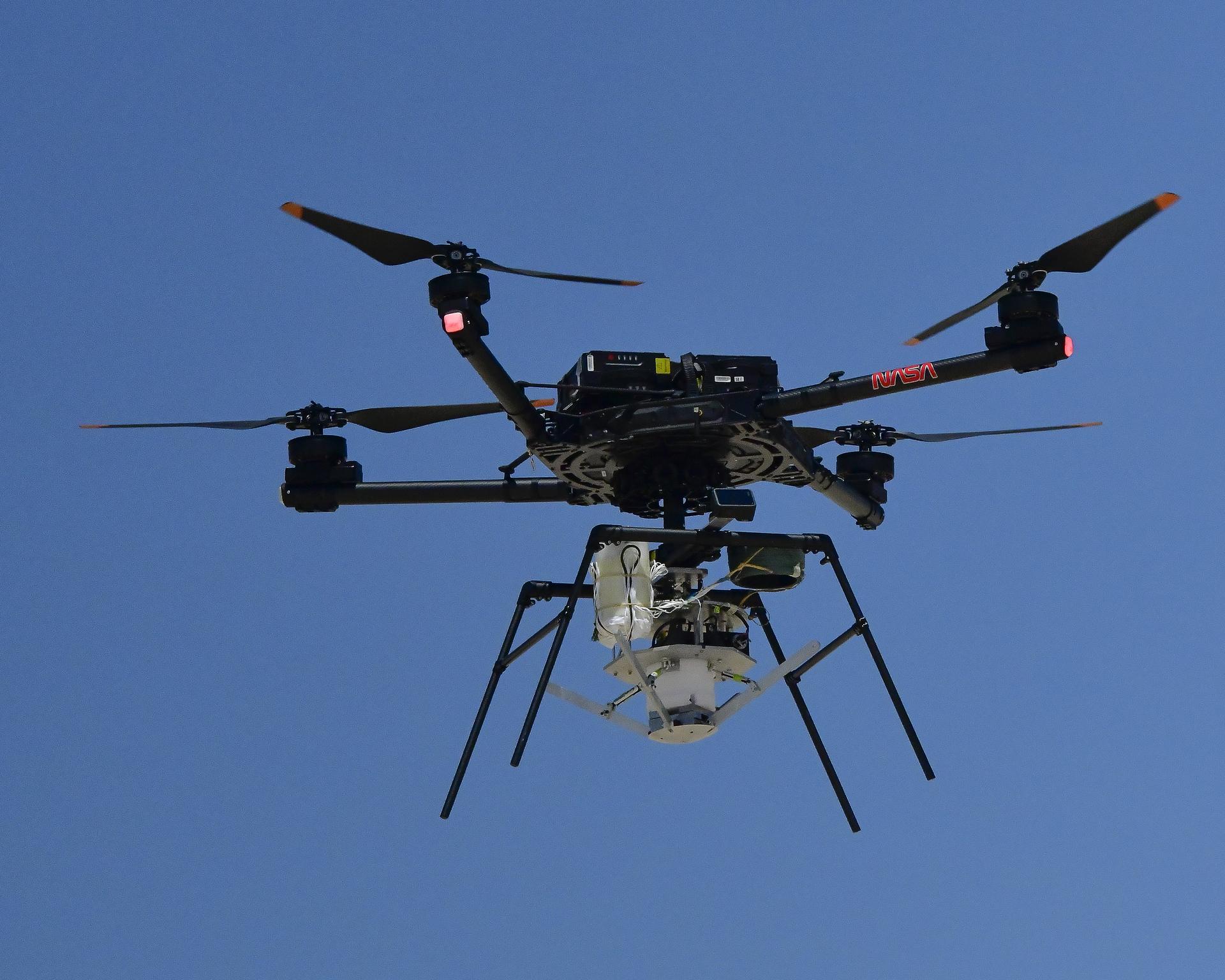
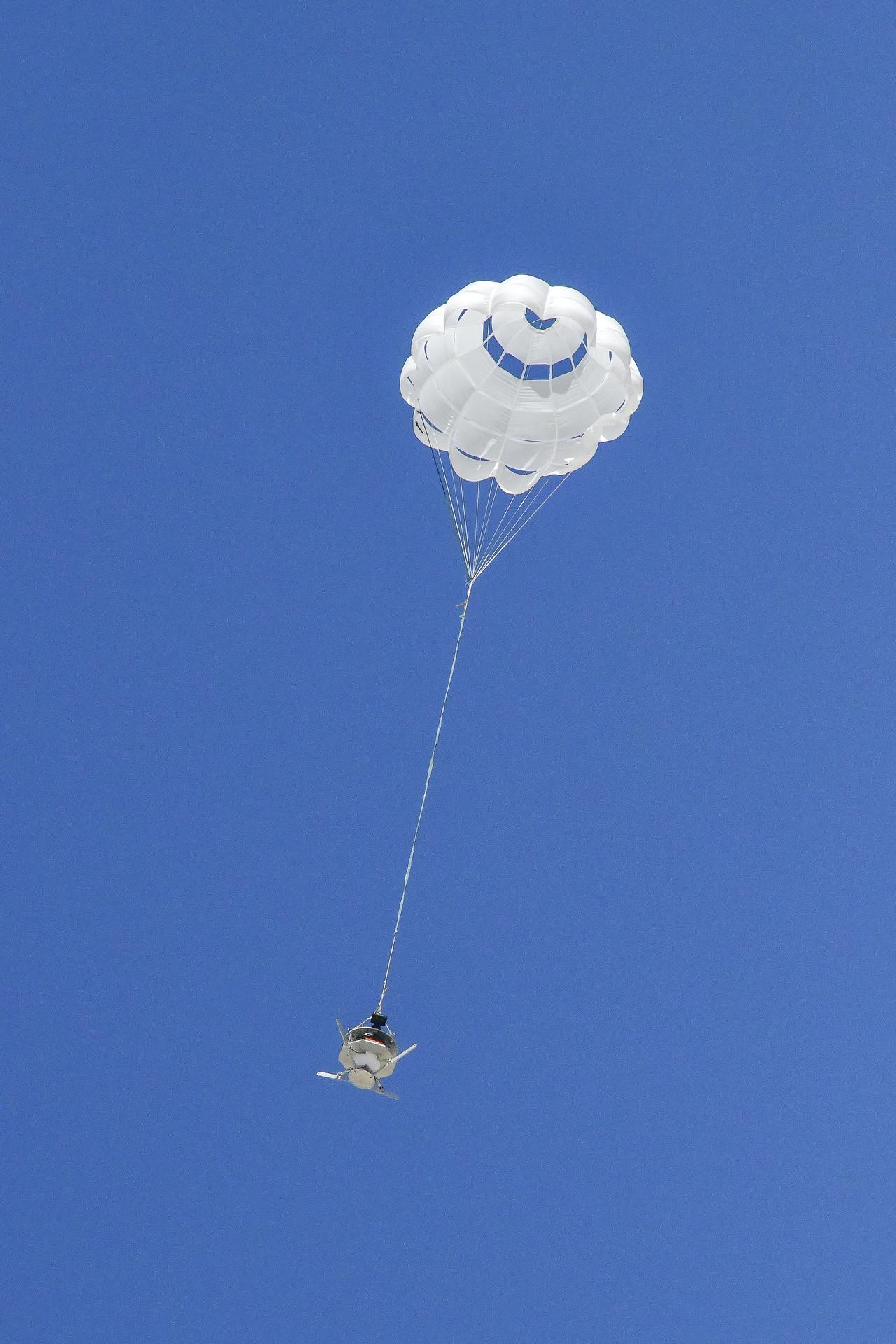
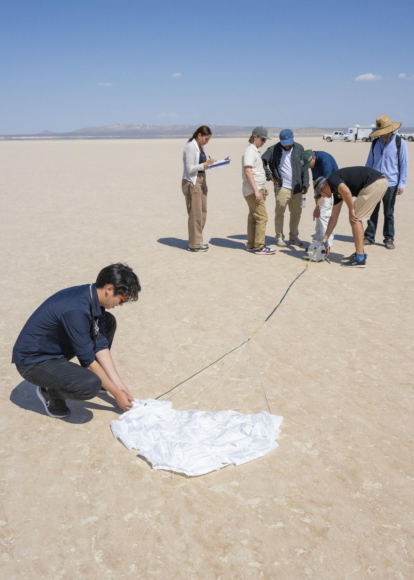
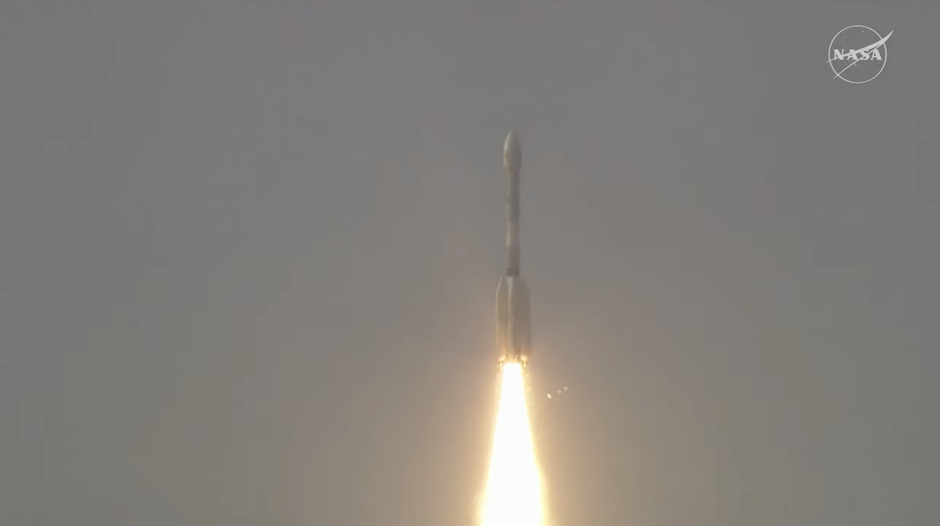
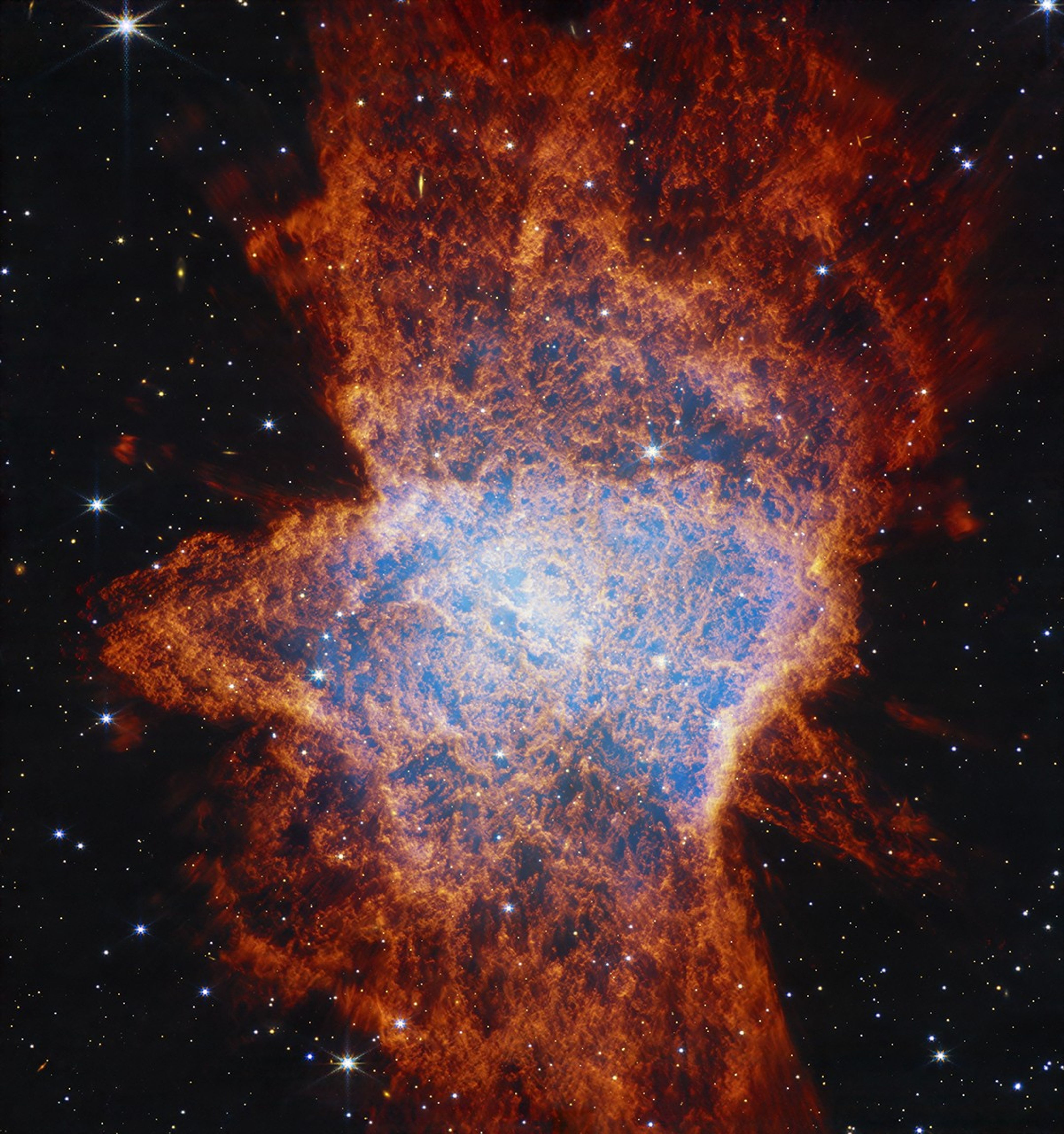
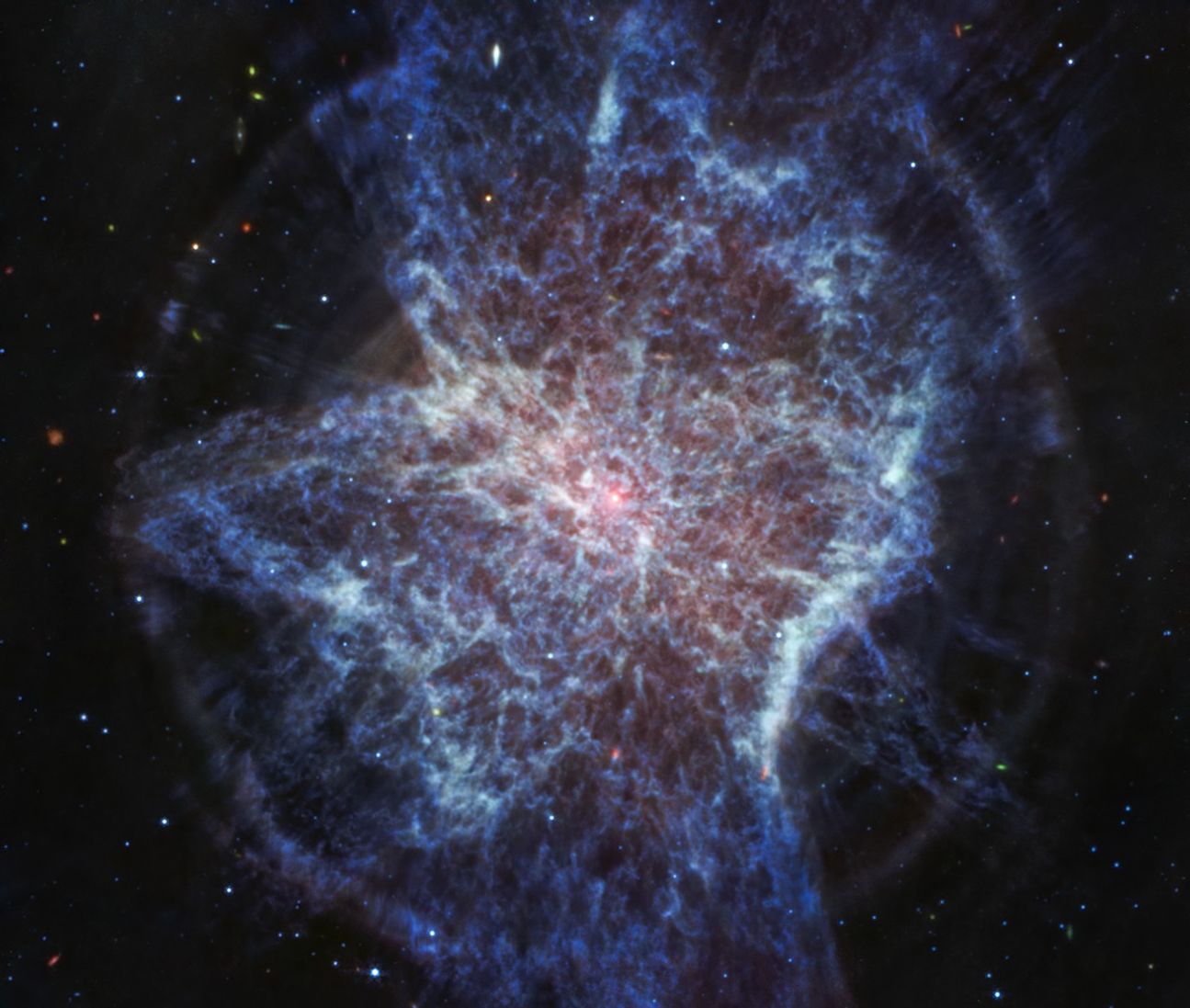
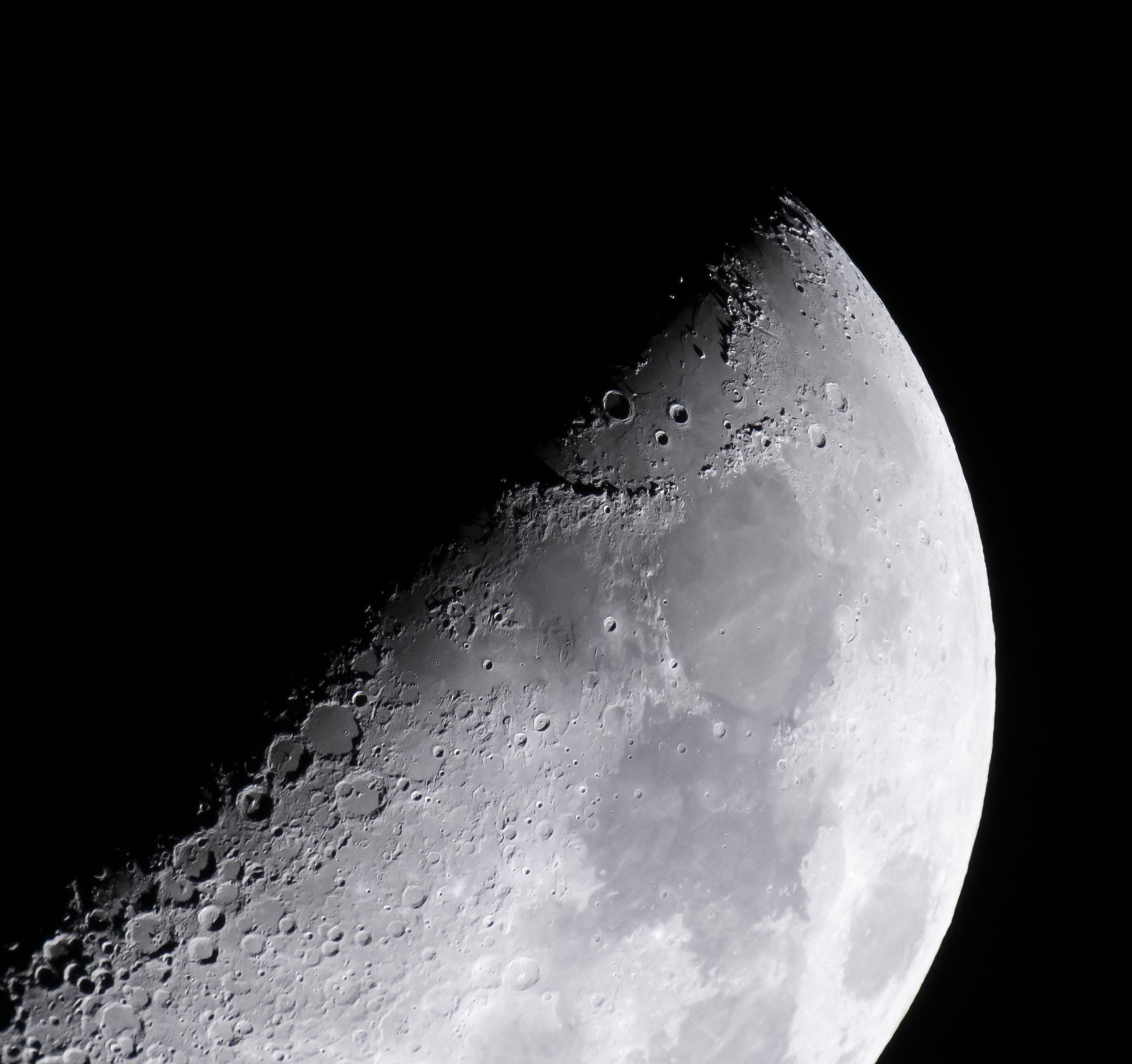
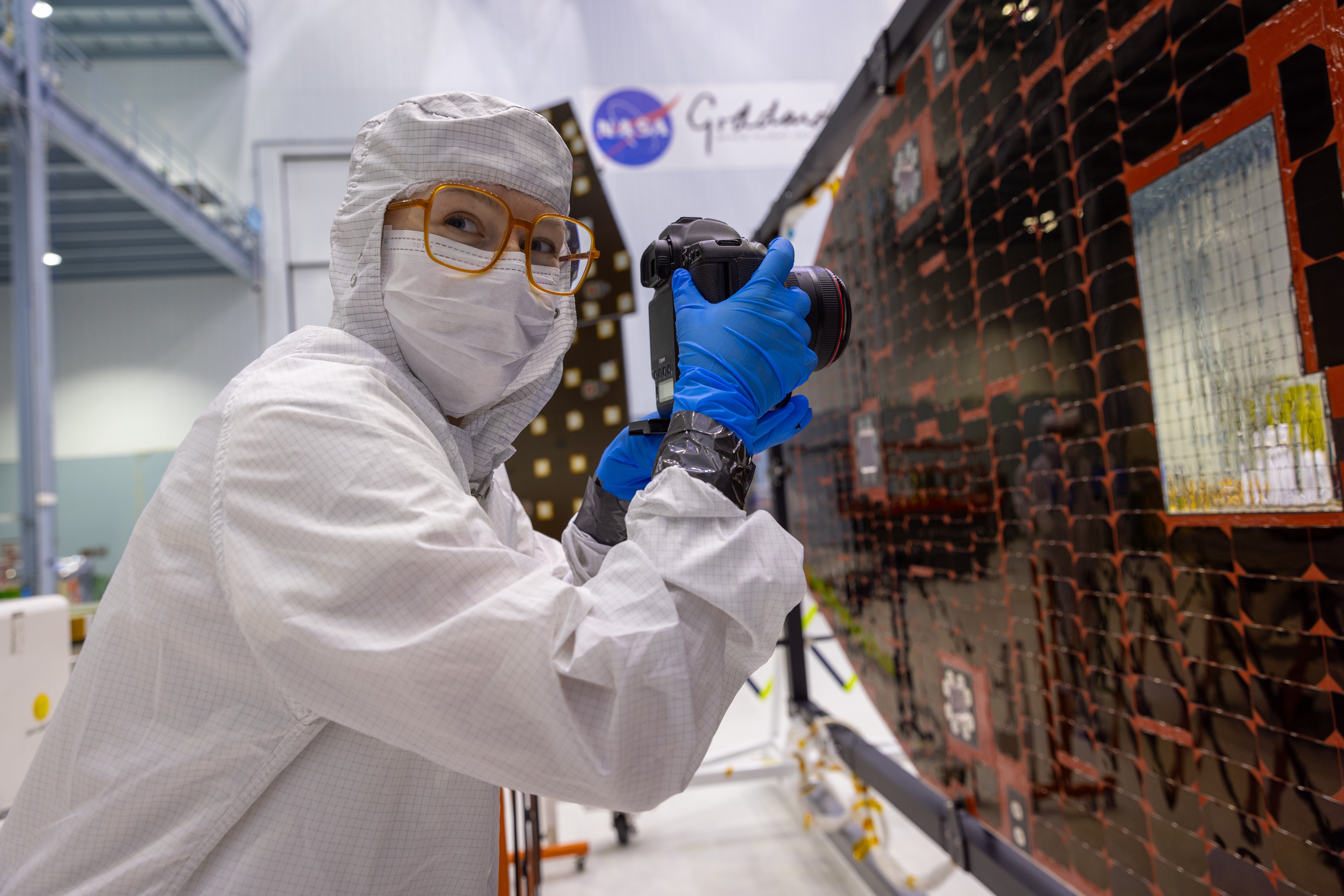
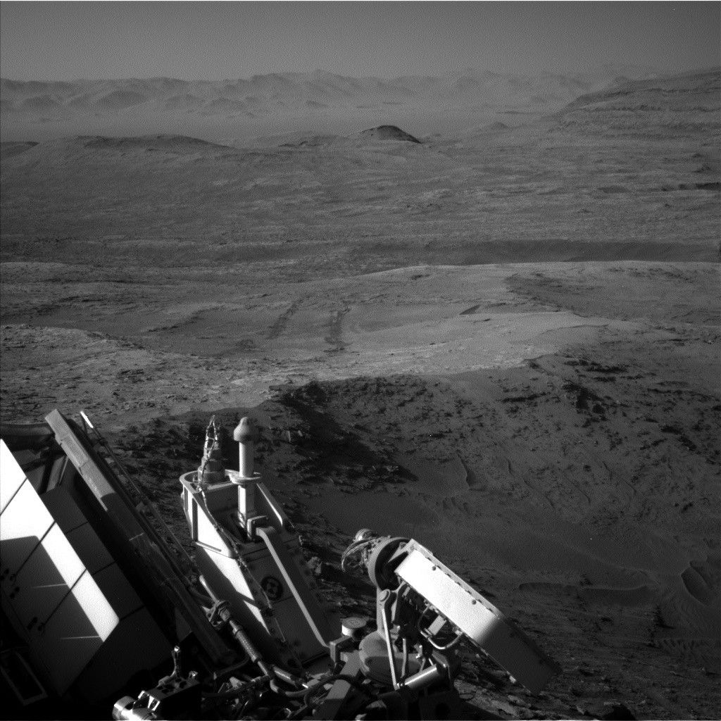
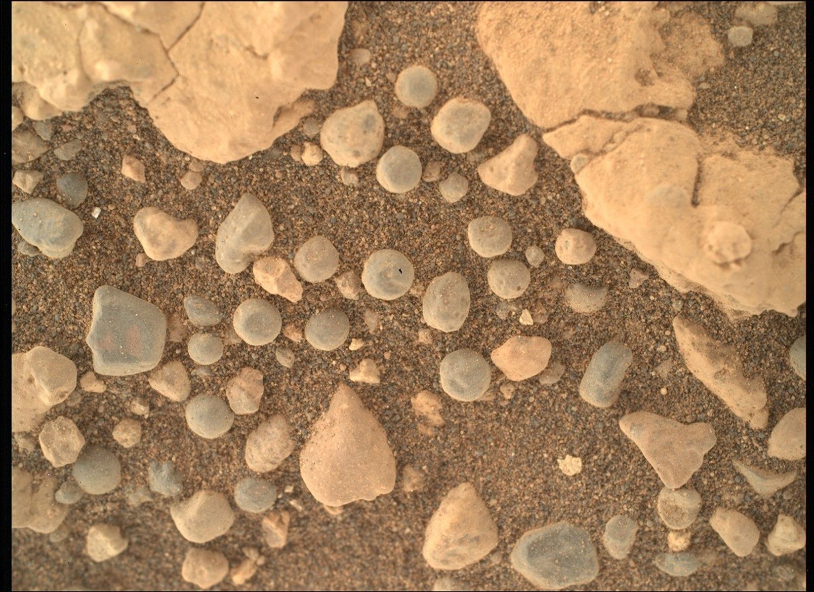