
NASA
Curiosity Blog, Sols 4595-4596: Just Another Beautiful Day on Mars
- Curiosity Home
- Science
- News and Features
- Multimedia
- Mars Missions
- Mars Home
3 min read
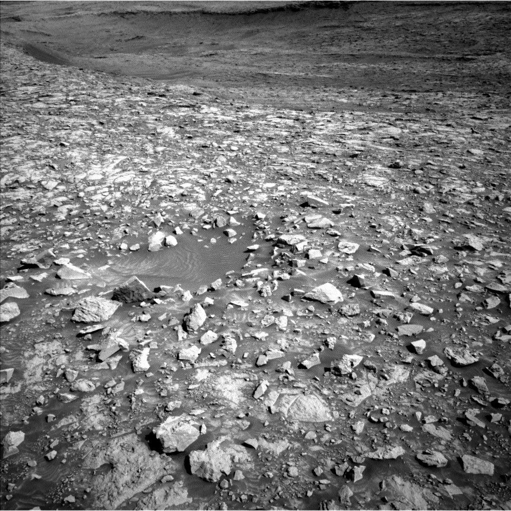
Curiosity Blog, Sols 4595-4596: Just Another Beautiful Day on Mars NASA’s Mars rover Curiosity acquired this image using its Left Navigation Camera on July 9, 2025 — Sol 4594, or Martian day 4,594 of the Mars Science Laboratory mission — at 11:03:48 UTC. NASA/JPL-CaltechWritten by Ashley Stroupe, Mission Operations Engineer at NASA’s Jet Propulsion Laboratory
Earth planning date: Wednesday, July 9, 2025
In today’s plan, we have a little bit of everything. With it being winter still, we are taking advantage of the ability to let the rover sleep in, doing most of the activities in the afternoon when it is warmer and we need less heating. As the Systems Engineer (Engineering Uplink Lead) today, I sequenced the needed heating and some other engineering housekeeping activities.
We start off with an extensive remote science block with Mastcam imaging of a nearby trough to look for potential sand activity. There is color imaging of a displaced block, “Ouro,” near a circular depression — could this be a small crater? Mastcam also takes a look at a ridge “Volcán Peña Blanca” to look at the sedimentary structures, which may provide insights into its formation. ChemCam LIBS and Mastcam team up to look at the “Los Andes” target, which is the dark face of a nearby piece of exposed bedrock. ChemCam RMI and Mastcam check out a distant small outcrop to examine the geometry of the layers. We also throw in environmental observations, a Mastcam solar Tau and a Navcam line-of-site looking at dust in the atmosphere. After a nap, Curiosity will be doing some contact science activities on “Cataratas del Jardín” and “Rio Ivirizu” bedrock targets. Looking at two nearby targets for variability can help us understand the local geology. Cataratas del Jardín gets a brushing to clear away the dust before both targets are examined by MAHLI and APXS. Fortunately for the Arm Rover Planner, both of these targets are fairly flat and easy to reach. Before going to sleep for the night, Curiosity will stow the arm to be ready for driving on the next sol.On the second sol, there is more remote science. ChemCam LIBS and Mastcam will examine “Torotoro,” another piece of layered bedrock. ChemCam RMI will take a mosaic of “Paniri,” which is an interesting incision in the rock that is filled with another material. There are also environmental observations, a Navcam dust devil survey and a suprahorizon movie. After another nap, Curiosity is getting on the road. We’re heading southwest (direction shown in the image) about 50 meters (about 164 feet), but we need to sneak between sandy pits and skirt around some terrain that we can’t see behind. The terrain here provides pretty nice driving, though, without a lot of big boulders, steep slopes, or pointy rocks that can poke holes in our wheels. After the standard post-drive imaging for our next plan, there are some Navcam observations to look for clouds and our normal look under the rover with MARDI before Curiosity goes to sleep for the night.
For more Curiosity blog posts, visit MSL Mission Updates
Learn more about Curiosity’s science instruments
Share Details Last Updated Jul 15, 2025 Related Terms Explore More 4 min read Curiosity Blog, Sols 4593-4594: Three Layers and a Lot of Structure at Volcán Peña Blanca
Article
4 days ago
3 min read Continuing the Quest for Clays
Article
7 days ago
2 min read Curiosity Blog, Sols 4589–4592: Setting up to explore Volcán Peña Blanca
Article
1 week ago
Keep Exploring Discover More Topics From NASA Mars
Mars is the fourth planet from the Sun, and the seventh largest. It’s the only planet we know of inhabited…
All Mars Resources
Explore this collection of Mars images, videos, resources, PDFs, and toolkits. Discover valuable content designed to inform, educate, and inspire,…
Rover Basics
Each robotic explorer sent to the Red Planet has its own unique capabilities driven by science. Many attributes of a…
Mars Exploration: Science Goals
The key to understanding the past, present or future potential for life on Mars can be found in NASA’s four…
Curiosity Blog, Sols 4595-4596: Just Another Beautiful Day on Mars
- Curiosity Home
- Science
- News and Features
- Multimedia
- Mars Missions
- Mars Home
3 min read
Curiosity Blog, Sols 4595-4596: Just Another Beautiful Day on Mars NASA’s Mars rover Curiosity acquired this image using its Left Navigation Camera on July 9, 2025 — Sol 4594, or Martian day 4,594 of the Mars Science Laboratory mission — at 11:03:48 UTC. NASA/JPL-CaltechWritten by Ashley Stroupe, Mission Operations Engineer at NASA’s Jet Propulsion Laboratory
Earth planning date: Wednesday, July 9, 2025
In today’s plan, we have a little bit of everything. With it being winter still, we are taking advantage of the ability to let the rover sleep in, doing most of the activities in the afternoon when it is warmer and we need less heating. As the Systems Engineer (Engineering Uplink Lead) today, I sequenced the needed heating and some other engineering housekeeping activities.
We start off with an extensive remote science block with Mastcam imaging of a nearby trough to look for potential sand activity. There is color imaging of a displaced block, “Ouro,” near a circular depression — could this be a small crater? Mastcam also takes a look at a ridge “Volcán Peña Blanca” to look at the sedimentary structures, which may provide insights into its formation. ChemCam LIBS and Mastcam team up to look at the “Los Andes” target, which is the dark face of a nearby piece of exposed bedrock. ChemCam RMI and Mastcam check out a distant small outcrop to examine the geometry of the layers. We also throw in environmental observations, a Mastcam solar Tau and a Navcam line-of-site looking at dust in the atmosphere. After a nap, Curiosity will be doing some contact science activities on “Cataratas del Jardín” and “Rio Ivirizu” bedrock targets. Looking at two nearby targets for variability can help us understand the local geology. Cataratas del Jardín gets a brushing to clear away the dust before both targets are examined by MAHLI and APXS. Fortunately for the Arm Rover Planner, both of these targets are fairly flat and easy to reach. Before going to sleep for the night, Curiosity will stow the arm to be ready for driving on the next sol.On the second sol, there is more remote science. ChemCam LIBS and Mastcam will examine “Torotoro,” another piece of layered bedrock. ChemCam RMI will take a mosaic of “Paniri,” which is an interesting incision in the rock that is filled with another material. There are also environmental observations, a Navcam dust devil survey and a suprahorizon movie. After another nap, Curiosity is getting on the road. We’re heading southwest (direction shown in the image) about 50 meters (about 164 feet), but we need to sneak between sandy pits and skirt around some terrain that we can’t see behind. The terrain here provides pretty nice driving, though, without a lot of big boulders, steep slopes, or pointy rocks that can poke holes in our wheels. After the standard post-drive imaging for our next plan, there are some Navcam observations to look for clouds and our normal look under the rover with MARDI before Curiosity goes to sleep for the night.
For more Curiosity blog posts, visit MSL Mission Updates
Learn more about Curiosity’s science instruments
Share Details Last Updated Jul 15, 2025 Related Terms Explore More 4 min read Curiosity Blog, Sols 4593-4594: Three Layers and a Lot of Structure at Volcán Peña Blanca
Article
4 days ago
3 min read Continuing the Quest for Clays
Article
7 days ago
2 min read Curiosity Blog, Sols 4589–4592: Setting up to explore Volcán Peña Blanca
Article
1 week ago
Keep Exploring Discover More Topics From NASA Mars
Mars is the fourth planet from the Sun, and the seventh largest. It’s the only planet we know of inhabited…
All Mars Resources
Explore this collection of Mars images, videos, resources, PDFs, and toolkits. Discover valuable content designed to inform, educate, and inspire,…
Rover Basics
Each robotic explorer sent to the Red Planet has its own unique capabilities driven by science. Many attributes of a…
Mars Exploration: Science Goals
The key to understanding the past, present or future potential for life on Mars can be found in NASA’s four…
Protected: Glenn Extreme Environments Rig (GEER)
This content is password protected. To view it please enter your password below:
Password:
Protected: Glenn Extreme Environments Rig (GEER)
This content is password protected. To view it please enter your password below:
Password:
Linking Satellite Data and Community Knowledge to Advance Alaskan Snow Science
4 min read
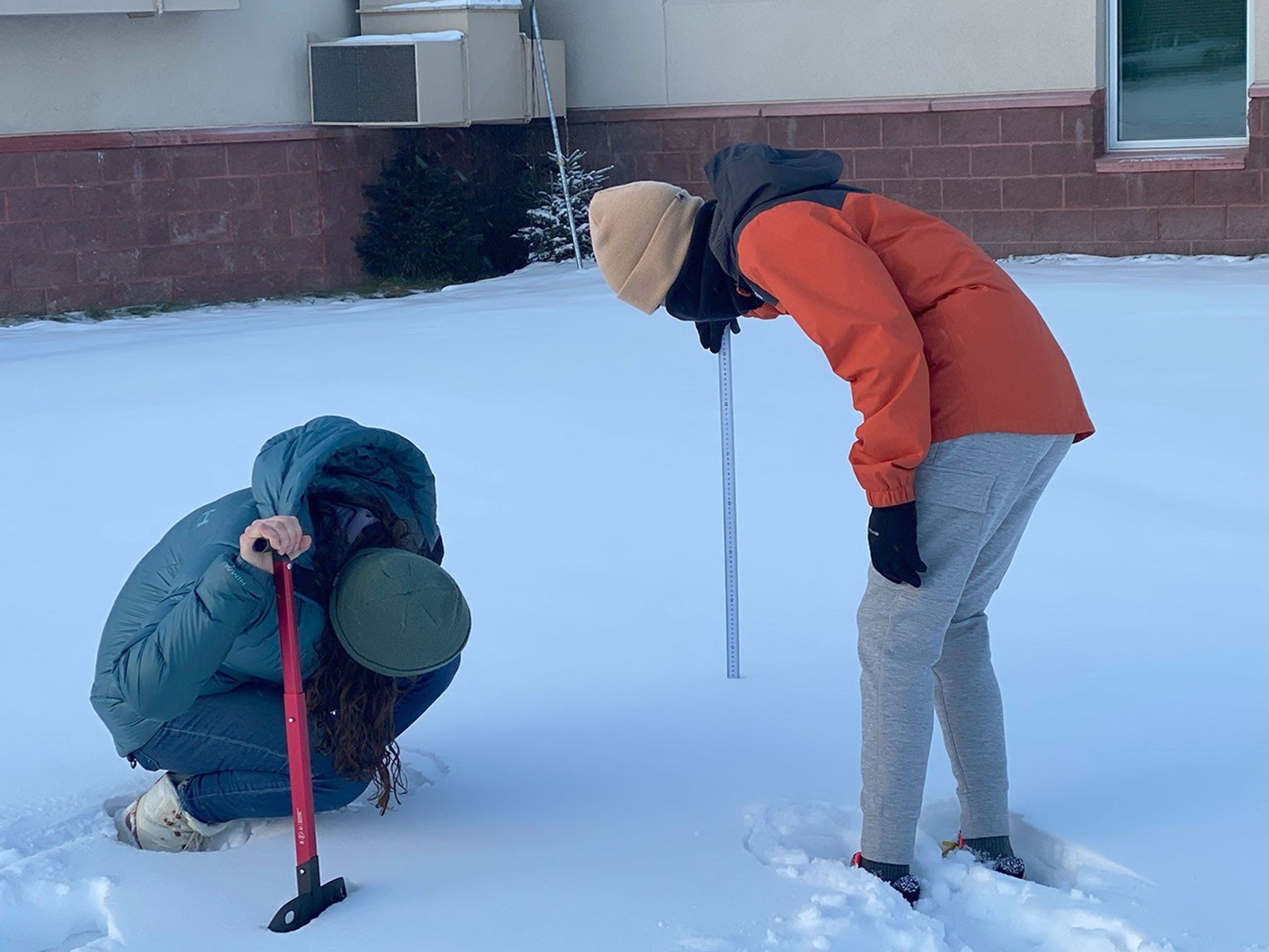
Linking Satellite Data and Community Knowledge to Advance Alaskan Snow ScienceSeasonal snow plays a significant role in global water and energy cycles, and billions of people worldwide rely on snowmelt for water resources needs, including water supply, hydropower, agriculture, and more. Monitoring snow water equivalent (SWE) is critical for supporting these applications and for mitigating damages caused by snowmelt flooding, avalanches, and other snow-related disasters. However, our ability to measure SWE remains a challenge, particularly in northern latitudes where in situ SWE observations are sparse and satellite observations are impacted by the boreal forest and environmental conditions. Despite limited in situ SWE measurements, local residents in Arctic and sub-Arctic regions provide a vast and valuable body of place-based knowledge and observations that are essential for understanding snowpack behavior in northern regions.
As part of a joint NASA SnowEx, NASA’s Minority University Research and Education Project (MUREP) for American Indian and Alaska Native STEM (Science, Technology, Engineering, & Mathematics) Engagement (MAIANSE), and Global Learning & Observations to Benefit the Environment (GLOBE) Program partnership, a team of scientists including NASA intern Julia White (NASA Goddard Space Flight Center, University of Alaska Fairbanks), Carrie Vuyovich (NASA Goddard Space Flight Center), Alicia Joseph (NASA Goddard Space Flight Center), and Christi Buffington (University of Alaska Fairbanks, GLOBE Implementation Office) is studying snow water equivalent (SWE) across Interior Alaska. This project combines satellite-based interferometric synthetic aperture radar (InSAR) data, primarily from the Sentinel-1 satellite, with ground-based observations from the Snow Telemetry (SNOTEL) network and GLOBE (Global Learning Observations to Benefit the Environment). Together, these data sources help the team investigate how SWE varies across the landscape and how it affects local ecosystems and communities. The team is also preparing for future integration of data from NASA’s upcoming NISAR (NASA ISRO Synthetic Aperture Radar) mission, which is expected to enhance SWE retrieval capabilities.
After a collaborative visit to the classroom of Tammie Kovalenko in November 2024, Delta Junction junior and senior high school students in vocational agriculture (Vo Ag) classes, including members of Future Farmers of America (FFA), began collecting GLOBE data on a snowdrift located just outside their classroom. As the project progressed, students developed their own research questions. One student, Fianna Rooney, took the project even further — presenting research posters at both the GLOBE International Virtual Science Symposium (IVSS) and both the FFA Regional and National Conventions. Her work highlights the growing role of Alaskan youth in science, and how student-led inquiry can enrich both education and research outcomes. (This trip was funded by the NASA Science Activation Program’s Arctic and Earth SIGNs – STEM Integrating GLOBE & NASA – project at the University of Alaska Fairbanks.)
In February 2025, the team collaborated with Delta Junction Junior High and High School students, along with the Delta Junction Trails Association, to conduct a GLOBE Intensive Observation Period (IOP), “Delta Junction Snowdrifts,” to collect Landcover photos, snow depth, and snow water equivalent data. Thanks to aligned interests and research goals at the Alaska Satellite Facility (ASF), the project was further expanded into Spring 2025. Collaborators from ASF and the Alaska Center for Unmanned Aircraft Systems Integration (ACUASI) collected high resolution airborne data over the snowdrift at the Delta Junction Junior and Senior High School. This complementary dataset helped strengthen connections between satellite observations and ground-based student measurements.
This effort, led by a NASA intern, scientists, students, and Alaskan community members, highlights the power of collaboration in advancing science and education. Next steps will include collaboration with Native Alaskan communities near Delta Junction, including the Healy Lake Tribe, whose vast, generational knowledge will be of great value to deepening our understanding of Alaskan snow dynamics.
Learn more about how NASA’s Science Activation program connects NASA science experts, real content, and experiences with community leaders to do science in ways that activate minds and promote deeper understanding of our world and beyond: https://science.nasa.gov/learn/about-science-activation/
Julia White and Delta Junction student following GLOBE protocols for snow depth. Tori Brannan Share Details Last Updated Jul 14, 2025 Editor NASA Science Editorial Team Location Goddard Space Flight Center Related Terms Explore More 2 min read Hubble Snaps Galaxy Cluster’s PortraitArticle
3 days ago
7 min read NASA’s Parker Solar Probe Snaps Closest-Ever Images to Sun
On its record-breaking pass by the Sun late last year, NASA’s Parker Solar Probe captured…
Article
4 days ago
8 min read NASA’s Webb Scratches Beyond Surface of Cat’s Paw for 3rd Anniversary
Article
4 days ago
Keep Exploring Discover More Topics From NASA James Webb Space Telescope
Webb is the premier observatory of the next decade, serving thousands of astronomers worldwide. It studies every phase in the…
Perseverance Rover
This rover and its aerial sidekick were assigned to study the geology of Mars and seek signs of ancient microbial…
Parker Solar Probe
On a mission to “touch the Sun,” NASA’s Parker Solar Probe became the first spacecraft to fly through the corona…
Juno
NASA’s Juno spacecraft entered orbit around Jupiter in 2016, the first explorer to peer below the planet’s dense clouds to…
Linking Satellite Data and Community Knowledge to Advance Alaskan Snow Science
4 min read
Linking Satellite Data and Community Knowledge to Advance Alaskan Snow ScienceSeasonal snow plays a significant role in global water and energy cycles, and billions of people worldwide rely on snowmelt for water resources needs, including water supply, hydropower, agriculture, and more. Monitoring snow water equivalent (SWE) is critical for supporting these applications and for mitigating damages caused by snowmelt flooding, avalanches, and other snow-related disasters. However, our ability to measure SWE remains a challenge, particularly in northern latitudes where in situ SWE observations are sparse and satellite observations are impacted by the boreal forest and environmental conditions. Despite limited in situ SWE measurements, local residents in Arctic and sub-Arctic regions provide a vast and valuable body of place-based knowledge and observations that are essential for understanding snowpack behavior in northern regions.
As part of a joint NASA SnowEx, NASA’s Minority University Research and Education Project (MUREP) for American Indian and Alaska Native STEM (Science, Technology, Engineering, & Mathematics) Engagement (MAIANSE), and Global Learning & Observations to Benefit the Environment (GLOBE) Program partnership, a team of scientists including NASA intern Julia White (NASA Goddard Space Flight Center, University of Alaska Fairbanks), Carrie Vuyovich (NASA Goddard Space Flight Center), Alicia Joseph (NASA Goddard Space Flight Center), and Christi Buffington (University of Alaska Fairbanks, GLOBE Implementation Office) is studying snow water equivalent (SWE) across Interior Alaska. This project combines satellite-based interferometric synthetic aperture radar (InSAR) data, primarily from the Sentinel-1 satellite, with ground-based observations from the Snow Telemetry (SNOTEL) network and GLOBE (Global Learning Observations to Benefit the Environment). Together, these data sources help the team investigate how SWE varies across the landscape and how it affects local ecosystems and communities. The team is also preparing for future integration of data from NASA’s upcoming NISAR (NASA ISRO Synthetic Aperture Radar) mission, which is expected to enhance SWE retrieval capabilities.
After a collaborative visit to the classroom of Tammie Kovalenko in November 2024, Delta Junction junior and senior high school students in vocational agriculture (Vo Ag) classes, including members of Future Farmers of America (FFA), began collecting GLOBE data on a snowdrift located just outside their classroom. As the project progressed, students developed their own research questions. One student, Fianna Rooney, took the project even further — presenting research posters at both the GLOBE International Virtual Science Symposium (IVSS) and both the FFA Regional and National Conventions. Her work highlights the growing role of Alaskan youth in science, and how student-led inquiry can enrich both education and research outcomes. (This trip was funded by the NASA Science Activation Program’s Arctic and Earth SIGNs – STEM Integrating GLOBE & NASA – project at the University of Alaska Fairbanks.)
In February 2025, the team collaborated with Delta Junction Junior High and High School students, along with the Delta Junction Trails Association, to conduct a GLOBE Intensive Observation Period (IOP), “Delta Junction Snowdrifts,” to collect Landcover photos, snow depth, and snow water equivalent data. Thanks to aligned interests and research goals at the Alaska Satellite Facility (ASF), the project was further expanded into Spring 2025. Collaborators from ASF and the Alaska Center for Unmanned Aircraft Systems Integration (ACUASI) collected high resolution airborne data over the snowdrift at the Delta Junction Junior and Senior High School. This complementary dataset helped strengthen connections between satellite observations and ground-based student measurements.
This effort, led by a NASA intern, scientists, students, and Alaskan community members, highlights the power of collaboration in advancing science and education. Next steps will include collaboration with Native Alaskan communities near Delta Junction, including the Healy Lake Tribe, whose vast, generational knowledge will be of great value to deepening our understanding of Alaskan snow dynamics.
Learn more about how NASA’s Science Activation program connects NASA science experts, real content, and experiences with community leaders to do science in ways that activate minds and promote deeper understanding of our world and beyond: https://science.nasa.gov/learn/about-science-activation/
Julia White and Delta Junction student following GLOBE protocols for snow depth. Tori Brannan Share Details Last Updated Jul 14, 2025 Editor NASA Science Editorial Team Location Goddard Space Flight Center Related Terms Explore More 2 min read Hubble Snaps Galaxy Cluster’s PortraitArticle
3 days ago
7 min read NASA’s Parker Solar Probe Snaps Closest-Ever Images to Sun
On its record-breaking pass by the Sun late last year, NASA’s Parker Solar Probe captured…
Article
4 days ago
8 min read NASA’s Webb Scratches Beyond Surface of Cat’s Paw for 3rd Anniversary
Article
4 days ago
Keep Exploring Discover More Topics From NASA James Webb Space Telescope
Webb is the premier observatory of the next decade, serving thousands of astronomers worldwide. It studies every phase in the…
Perseverance Rover
This rover and its aerial sidekick were assigned to study the geology of Mars and seek signs of ancient microbial…
Parker Solar Probe
On a mission to “touch the Sun,” NASA’s Parker Solar Probe became the first spacecraft to fly through the corona…
Juno
NASA’s Juno spacecraft entered orbit around Jupiter in 2016, the first explorer to peer below the planet’s dense clouds to…
10 Years Ago: NASA’s New Horizons Captures Pluto’s Heart
10 Years Ago: NASA’s New Horizons Captures Pluto’s Heart
This image, taken by NASA’s New Horizons spacecraft on July 14, 2015, is the most accurate natural color image of Pluto. This natural-color image results from refined calibration of data gathered by New Horizons’ color Multispectral Visible Imaging Camera (MVIC). The processing creates images that would approximate the colors that the human eye would perceive, bringing them closer to “true color” than the images released near the encounter. This single color MVIC scan includes no data from other New Horizons imagers or instruments added. The striking features on Pluto are clearly visible, including the bright expanse of Pluto’s icy, nitrogen-and-methane rich “heart,” Sputnik Planitia.
Image credit: NASA/Johns Hopkins University Applied Physics Laboratory/Southwest Research Institute/Alex Parker
Chief Training Officer Teresa Sindelar Touches the Future of Human Spaceflight
Teresa Sindelar always knew she wanted to be a part of human spaceflight, but she was unsure how to make that dream a reality until a chance encounter with former NASA astronaut Tom Stafford when she was 11 years old.
The pair met in a local jewelry shop near Sindelar’s Nebraska home, where Gen. Stafford was signing autographs. In addition to his photo, Gen. Stafford gave Sindelar a valuable tip – she should check out the Kansas Cosmosphere, a space museum in Hutchinson, Kansas. “I proceeded to attend every camp the Cosmosphere offered as a student, interned during college, and worked there full time while earning my graduate degree,” Sindelar said.
Official portrait of Teresa Sindelar.NASAShe discovered a passion for teaching and mentoring young students through her work in the museum’s education department and a stint as a high school science teacher. When she began looking for opportunities at NASA, she sought a position that melded instruction with technical work. “I like pouring into others and watching them grow,” she said.
Today, Sindelar is a chief training officer (CTO) within the Flight Operations Directorate at NASA’s Johnson Space Center in Houston. Along with her fellow CTOs, Sindelar oversees the correct and complete training of NASA astronauts, crew members representing international partners, and all flight controllers. “I put the pieces together,” she said. “It is my job to make sure instructors, schedulers, outside partners, facility managers, and others are all in sync.” She added that CTOs have a unique position because they see the big picture of a training flow and understand the long-term training goals and objectives.
Teresa Sindelar received a 2025 Space Flight Awareness Program Honoree Award, presented by NASA astronaut Randy Bresnik.NASA“I get to do a lot of cool things and go to a lot of cool places,” she said, noting that the training facilities at Johnson and other NASA centers, as well as facilities managed by international partners, are top-notch. While she does enjoy watching astronauts work through problems and learn new systems, she has a special fondness for flight controller training and mentoring young professionals. “What fills my cup the most is seeing a brand-new employee right out of college blossom into a confident flight controller, do their job well, and make our missions better,” she said. “I like knowing that I had something to do with that.”
Sindelar has been part of the Johnson team since 2010 and worked as an educator in what was then called the center’s Office of Education and as a crew training instructor in the Space Medicine Operations Directorate before becoming a CTO. In March 2025, Sindelar received a Space Flight Awareness Program Honoree Award for her outstanding leadership in the Private Astronaut Mission (PAM) program, which is an important component of NASA’s strategy for enabling a robust and competitive commercial economy in low Earth orbit. As the lead CTO for the third PAM, Axiom Mission 3, Sindelar managed training while identifying critical inefficiencies, enhancing mission safety and performance. She spearheaded a key stakeholder retreat to streamline operations, reorganized training resources for improved accessibility, and implemented efficiency improvements that optimized mission support. Sindelar’s work was recognized during an award ceremony at NASA’s Kennedy Space Center in Florida, and she got to attend the launch of NASA’s SpaceX Crew-10 mission as a special guest.
In her 15 years with the agency, she has learned the importance of leading by example. “My team needs to see that I meet the bar I set,” she said. “Leading is about motivating your people so they are committed, not just compliant.”
Teresa Sindelar (front row, third from left) and her Space Medicine Operations crew training team with the crew members of Expedition 48.NASAKeeping a team motivated and on track is particularly important to training success and safety. “We only get a matter of months to train astronauts to do the most hazardous activities that humans have done, or to train flight controllers who literally have the mission and the lives of astronauts in their hands,” Sindelar said, adding that they cannot afford to have an unfocused or indifferent team.
Sindelar observed that Johnson’s training team is acutely aware of their responsibilities. “We live and work in the same communities as the crew members,” she said. “We see them at school functions, at the grocery store, at the park. We know their families are counting on us to bring their loved ones home safely.”
She has also learned that her voice matters. “When I was a young professional, I just never felt I could be influential, but the only person holding me back was me,” she said. “I had to learn to trust in my own instincts. That was definitely outside of my comfort zone.” She credits her mentors with helping her build confidence and knowing when and how to speak up. “I have had many giants of the spaceflight community mold and shape me in my career, from my counselors at the Cosmosphere all the way to flight directors and astronauts,” she said. “It is my privilege to learn from them, and I am grateful to each of them.”
Outside of work, Sindelar uses her voice in a different way – as part of her church choir. She also plays piano, stating that she is as passionate about music and volunteerism as she is about human spaceflight. She is a member of the Friendswood Volunteer Fire Department, as well, serving on its rehab team and as the department’s chaplain
Teresa Sindelar (second from right) and her family with a Friendswood Volunteer Fire Department fire engine. Image courtesy of Teresa SindelarAs NASA prepares to return humans to the Moon and journey on to Mars, Sindelar hopes she has taught the next generation of explorers enough so they can show the world the wonders of the universe. “This next generation will see and do things my generation never even thought of,” she said, adding that it is time for them to start leading. “Use your voice. Take care of each other along the way. Reach out and help the next one in line.”
Sindelar keeps a reminder of that important message on her desk: the picture Gen. Stafford signed all those years ago.
Explore More 3 min read Melissa Harris: Shaping NASA’s Vision for a Future in Low Earth Orbit Article 6 hours ago 5 min read Protected: Glenn Extreme Environments Rig (GEER) Article 21 hours ago 3 min read NASA Aircraft, Sensor Technology, Aid in Texas Flood Recovery Efforts Article 6 days agoChief Training Officer Teresa Sindelar Touches the Future of Human Spaceflight
Teresa Sindelar always knew she wanted to be a part of human spaceflight, but she was unsure how to make that dream a reality until a chance encounter with former NASA astronaut Tom Stafford when she was 11 years old.
The pair met in a local jewelry shop near Sindelar’s Nebraska home, where Gen. Stafford was signing autographs. In addition to his photo, Gen. Stafford gave Sindelar a valuable tip – she should check out the Kansas Cosmosphere, a space museum in Hutchinson, Kansas. “I proceeded to attend every camp the Cosmosphere offered as a student, interned during college, and worked there full time while earning my graduate degree,” Sindelar said.
Official portrait of Teresa Sindelar.NASAShe discovered a passion for teaching and mentoring young students through her work in the museum’s education department and a stint as a high school science teacher. When she began looking for opportunities at NASA, she sought a position that melded instruction with technical work. “I like pouring into others and watching them grow,” she said.
Today, Sindelar is a chief training officer (CTO) within the Flight Operations Directorate at NASA’s Johnson Space Center in Houston. Along with her fellow CTOs, Sindelar oversees the correct and complete training of NASA astronauts, crew members representing international partners, and all flight controllers. “I put the pieces together,” she said. “It is my job to make sure instructors, schedulers, outside partners, facility managers, and others are all in sync.” She added that CTOs have a unique position because they see the big picture of a training flow and understand the long-term training goals and objectives.
Teresa Sindelar received a 2025 Space Flight Awareness Program Honoree Award, presented by NASA astronaut Randy Bresnik.NASA“I get to do a lot of cool things and go to a lot of cool places,” she said, noting that the training facilities at Johnson and other NASA centers, as well as facilities managed by international partners, are top-notch. While she does enjoy watching astronauts work through problems and learn new systems, she has a special fondness for flight controller training and mentoring young professionals. “What fills my cup the most is seeing a brand-new employee right out of college blossom into a confident flight controller, do their job well, and make our missions better,” she said. “I like knowing that I had something to do with that.”
Sindelar has been part of the Johnson team since 2010 and worked as an educator in what was then called the center’s Office of Education and as a crew training instructor in the Space Medicine Operations Directorate before becoming a CTO. In March 2025, Sindelar received a Space Flight Awareness Program Honoree Award for her outstanding leadership in the Private Astronaut Mission (PAM) program, which is an important component of NASA’s strategy for enabling a robust and competitive commercial economy in low Earth orbit. As the lead CTO for the third PAM, Axiom Mission 3, Sindelar managed training while identifying critical inefficiencies, enhancing mission safety and performance. She spearheaded a key stakeholder retreat to streamline operations, reorganized training resources for improved accessibility, and implemented efficiency improvements that optimized mission support. Sindelar’s work was recognized during an award ceremony at NASA’s Kennedy Space Center in Florida, and she got to attend the launch of NASA’s SpaceX Crew-10 mission as a special guest.
In her 15 years with the agency, she has learned the importance of leading by example. “My team needs to see that I meet the bar I set,” she said. “Leading is about motivating your people so they are committed, not just compliant.”
Teresa Sindelar (front row, third from left) and her Space Medicine Operations crew training team with the crew members of Expedition 48.NASAKeeping a team motivated and on track is particularly important to training success and safety. “We only get a matter of months to train astronauts to do the most hazardous activities that humans have done, or to train flight controllers who literally have the mission and the lives of astronauts in their hands,” Sindelar said, adding that they cannot afford to have an unfocused or indifferent team.
Sindelar observed that Johnson’s training team is acutely aware of their responsibilities. “We live and work in the same communities as the crew members,” she said. “We see them at school functions, at the grocery store, at the park. We know their families are counting on us to bring their loved ones home safely.”
She has also learned that her voice matters. “When I was a young professional, I just never felt I could be influential, but the only person holding me back was me,” she said. “I had to learn to trust in my own instincts. That was definitely outside of my comfort zone.” She credits her mentors with helping her build confidence and knowing when and how to speak up. “I have had many giants of the spaceflight community mold and shape me in my career, from my counselors at the Cosmosphere all the way to flight directors and astronauts,” she said. “It is my privilege to learn from them, and I am grateful to each of them.”
Outside of work, Sindelar uses her voice in a different way – as part of her church choir. She also plays piano, stating that she is as passionate about music and volunteerism as she is about human spaceflight. She is a member of the Friendswood Volunteer Fire Department, as well, serving on its rehab team and as the department’s chaplain
Teresa Sindelar (second from right) and her family with a Friendswood Volunteer Fire Department fire engine. Image courtesy of Teresa SindelarAs NASA prepares to return humans to the Moon and journey on to Mars, Sindelar hopes she has taught the next generation of explorers enough so they can show the world the wonders of the universe. “This next generation will see and do things my generation never even thought of,” she said, adding that it is time for them to start leading. “Use your voice. Take care of each other along the way. Reach out and help the next one in line.”
Sindelar keeps a reminder of that important message on her desk: the picture Gen. Stafford signed all those years ago.
Explore More 3 min read Melissa Harris: Shaping NASA’s Vision for a Future in Low Earth Orbit Article 6 hours ago 5 min read Protected: Glenn Extreme Environments Rig (GEER) Article 21 hours ago 3 min read NASA Aircraft, Sensor Technology, Aid in Texas Flood Recovery Efforts Article 6 days agoAdvances in NASA Imaging Changed How World Sees Mars
6 min read
Preparations for Next Moonwalk Simulations Underway (and Underwater) NASA’s Mariner 4 captured the first-ever close-up image of Mars on July 14, 1965. While waiting for the data to be processed into the image (inset at right), team members hand-colored strips of paper that the data was printed on, assigning hues to value ranges. The result is on display at JPL.NASA/JPL-CaltechSixty years ago, NASA’s Mariner 4 captured groundbreaking views of the Red Planet, leading to a steady stream of advances in the cameras used to study other worlds.
In 1965, NASA’s Mariner 4 mission brought Mars into American living rooms, where TV sets showed fuzzy black-and-white images of a cratered landscape. The spacecraft took 21 complete pictures — the first ever captured of another planet — as it flew by as close as 6,118 miles (9,846 kilometers) above the surface.
The mission team couldn’t wait to see what the camera aboard the spacecraft would return. When the actual images were delayed, they went so far as to create a color-by-numbers image, assigning hues to specific values in the data.
Their handiwork wasn’t far off, and the barren landscape Mariner 4 captured ignited the imaginations of future scientists and engineers who would go on to work on a succession of missions, each revealing Mars in a way it had never been seen before.
Millions of Mars images have been taken since then, many of which are captivating in their own way. The images that follow highlight some of the “firsts” in the way the agency has used imaging to help unlock the secrets of Mars.
Viking 1 Sets Foot on MarsJuly 20, 1976
This historic image — the first from the surface of Mars — confirmed that NASA’s Viking 1 lander had become the first spacecraft to touch down on the Red Planet on July 20, 1976. NASA/JPL-CaltechViking 1 became the first spacecraft to touch down on Mars on July 20, 1976. The first high-resolution image it sent to Earth captured a dry, rocky landscape that dashed any hope among scientists of discovering life on the surface. But the crisp images that followed from the lander’s 360-degree cylindrical scan camera underscored the scientific value of seeing Mars from the ground and generated excitement for a more ambitious visit: a robotic spacecraft that could drive across this alien world.
Portrait of Mars by Viking 1 Orbiter1980
NASA’s twin Viking landers didn’t travel alone. Two accompanying orbiters circled Mars to study it from above. The Viking 1 orbiter captured many images in 1980 that were combined to produce this view of Valles Marineris, the “Grand Canyon of Mars.”NASA/JPL-Caltech/USGSWhen the twin Viking landers arrived at Mars, each descended from an orbiter that used cameras to map Mars in a way Earth-based telescopes couldn’t. They began capturing images before the landers even touched down, continuing until 1980. That year, the Viking 1 orbiter captured images that were later stitched into a defining portrait of Valles Marineris — the “Grand Canyon of Mars.”
Sojourner Starts to ExploreJuly 5, 1997
The size of a microwave oven, NASA’s Sojourner rover was the first spacecraft to drive on Mars, as seen in this image taken by NASA’s Pathfinder lander on July 5, 1997. The rover explored the Martian surface for 83 days, well beyond its planned seven-day mission.NASA/JPL-CaltechBy the time NASA returned to the Martian surface in 1997 with the Pathfinder lander and its microwave-oven-size Sojourner rover, much had changed on Earth since Mariner 4’s images beamed to TV viewers: Now, the internet was bringing around-the-clock news to personal computers, allowing a young generation of space fans to witness the tentative first steps of a new form of planetary exploration. The panoramic images from the ground were the first since Viking and, as part of NASA’s “faster, better, cheaper” initiative, offered more detail and a comparatively lower cost.
Opportunity Spots Passing Dust DevilMarch 31, 2016
NASA’s Spirit and Opportunity rovers crossed many miles of Martian terrain, capturing stunning vistas and passing dust devils along the way. The twins far outlasted their planned mission of 90 days: Spirit traveled the Red Planet for more than six years, while Opportunity journeyed for almost 15.NASA/JPL-CaltechIn 2004, NASA’s golf-cart-size twin rovers Spirit and Opportunity set down on the Red Planet, beginning a new phase of Martian exploration. Equipped with both mast-mounted panoramic and arm-mounted microscopic imagers, the roving spacecraft let scientists, engineers, and the world discover new terrain each day. They captured colorful views of Martian vistas and revealed details of pebble-size “blueberries.” Mars was beginning to feel less like an unfamiliar world than a place with recognizable landmarks.
MRO’s HiRISE Views Victoria CraterJuly 18, 2009
More advanced orbiters have brought a different perspective of the Red Planet — especially NASA’s Mars Reconnaissance Orbiter, which uses its HiRISE camera to see surface features that appeared blurry in earlier images. Here, HiRISE views Victoria Crater.NASA/JPL-Caltech/University of ArizonaSince Viking, a series of increasingly advanced orbiters have arrived at Mars with new science tools and cameras. Using increasingly sophisticated imagers, they have mapped the planet’s hills and valleys, identified significant minerals, and found buried glaciers. A camera that has been in operation aboard NASA’s Mars Reconnaissance Orbiter since 2006, the High-Resolution Imaging Science Experiment (HiRISE) frequently captures individual dunes, boulders, and craters, as with this picture of Victoria Crater, revealing features that had been blurry in previous images. The camera has also identified landing sites and places where future rovers (perhaps even astronauts) could explore.
Curiosity, Perseverance Bring More Cameras and ColorAug. 5, 2012 and Feb. 18, 2021
Curiosity Perseverance NASA/JPL-Caltech NASA/JPL-Caltech CuriosityPerseverance NASA/JPL-Caltech NASA/JPL-Caltech Curiosity Perseverance More Cameras, More Color CurtainToggle2-Up Image Details NASA’s Curiosity and Perseverance rovers each brought more cameras — and more color — to the Martian surface. One example are the hazard-avoidance cameras, which are black-and-white on Curiosity, left, and higher-resolution color on Perseverance. NASA/JPL-CaltechBoth Curiosity and Perseverance arrived at Mars (in 2012 and 2021, respectively) loaded with cameras that pack millions of pixels into their images and peer farther into the distance than Spirit or Opportunity ever could. They also feature upgraded arm-mounted cameras for studying fine details like sand particles and rock textures. Perseverance took a step beyond Curiosity in several ways, including with high-speed cameras that showed its parachute deploying and its rocket-powered jetpack flying away during entry, descent, and landing on Mars. Another advance can be seen in each vehicle’s hazard-avoidance cameras, which help rover drivers spot rocks they might bump into. As seen in the first images each rover sent back, Curiosity’s black-and-white cameras were upgraded to color and higher resolution for Perseverance, providing clearer views of the surface.
Ingenuity Spots Perseverance at Belva CraterAug. 22, 2023
NASA’s Perseverance landed along with the Ingenuity helicopter, which proved flight in Mars’ thin atmosphere was possible. This view from Ingenuity — taken from an altitude of about 40 feet (12 meters) during its 51st flight — includes the rover, visible as a whitish speck at upper left.NASA/JPL-CaltechJust as Pathfinder brought the tiny Sojourner rover to Mars, NASA’s next-generation Perseverance rover carried the Ingenuity helicopter. Along with proving flight in Mars’ thin air was possible, Ingenuity used a commercial, off-the-shelf color camera to take aerial views over the course of 72 flights. During one of those flights, Ingenuity even spotted Perseverance in the distance — another first on the Red Planet. Future Mars helicopters might be able to scout paths ahead and find scientifically interesting sites for robots and astronauts alike.
More About These MissionsNASA JPL, which is managed for the agency by Caltech in Pasadena, California, built Mariner 4, the Viking 1 and 2 orbiters, Pathfinder, Sojourner, Spirit and Opportunity, Curiosity, Perseverance, and Ingenuity. It continues to operate Curiosity and Perseverance.
Lockheed Martin Space in Denver built MRO and supports its operations, while JPL manages the mission. The University of Arizona, in Tucson, operates HiRISE, which was built by BAE Systems, in Boulder, Colorado.
The Viking 1 and 2 landers were built by Martin Marietta; the Viking program was managed by NASA’s Langley Research Center in Hampton, Virginia. JPL led operations for the Viking landers and orbiters.
Mariner 4 Mars Flyby 60th Anniversary Media Reel News Media ContactsAndrew Good
Jet Propulsion Laboratory, Pasadena, Calif.
818-393-2433
andrew.c.good@jpl.nasa.gov
Karen Fox / Molly Wasser
NASA Headquarters, Washington
202-358-1600
karen.c.fox@nasa.gov / molly.l.wasser@nasa.gov
2025-088
Share Details Last Updated Jul 12, 2025 Related Terms Explore More 6 min read NASA Mars Orbiter Learns New Moves After Nearly 20 Years in Space Article 3 weeks ago 6 min read NASA’s Perseverance Rover Scours Mars for Science Article 3 weeks ago 5 min read NASA’s Curiosity Mars Rover Starts Unpacking Boxwork Formations Article 3 weeks ago Keep Exploring Discover Related TopicsMissions
Humans in Space
Climate Change
Solar System
Advances in NASA Imaging Changed How World Sees Mars
6 min read
Preparations for Next Moonwalk Simulations Underway (and Underwater) NASA’s Mariner 4 captured the first-ever close-up image of Mars on July 14, 1965. While waiting for the data to be processed into the image (inset at right), team members hand-colored strips of paper that the data was printed on, assigning hues to value ranges. The result is on display at JPL.NASA/JPL-CaltechSixty years ago, NASA’s Mariner 4 captured groundbreaking views of the Red Planet, leading to a steady stream of advances in the cameras used to study other worlds.
In 1965, NASA’s Mariner 4 mission brought Mars into American living rooms, where TV sets showed fuzzy black-and-white images of a cratered landscape. The spacecraft took 21 complete pictures — the first ever captured of another planet — as it flew by as close as 6,118 miles (9,846 kilometers) above the surface.
The mission team couldn’t wait to see what the camera aboard the spacecraft would return. When the actual images were delayed, they went so far as to create a color-by-numbers image, assigning hues to specific values in the data.
Their handiwork wasn’t far off, and the barren landscape Mariner 4 captured ignited the imaginations of future scientists and engineers who would go on to work on a succession of missions, each revealing Mars in a way it had never been seen before.
Millions of Mars images have been taken since then, many of which are captivating in their own way. The images that follow highlight some of the “firsts” in the way the agency has used imaging to help unlock the secrets of Mars.
Viking 1 Sets Foot on MarsJuly 20, 1976
This historic image — the first from the surface of Mars — confirmed that NASA’s Viking 1 lander had become the first spacecraft to touch down on the Red Planet on July 20, 1976. NASA/JPL-CaltechViking 1 became the first spacecraft to touch down on Mars on July 20, 1976. The first high-resolution image it sent to Earth captured a dry, rocky landscape that dashed any hope among scientists of discovering life on the surface. But the crisp images that followed from the lander’s 360-degree cylindrical scan camera underscored the scientific value of seeing Mars from the ground and generated excitement for a more ambitious visit: a robotic spacecraft that could drive across this alien world.
Portrait of Mars by Viking 1 Orbiter1980
NASA’s twin Viking landers didn’t travel alone. Two accompanying orbiters circled Mars to study it from above. The Viking 1 orbiter captured many images in 1980 that were combined to produce this view of Valles Marineris, the “Grand Canyon of Mars.”NASA/JPL-Caltech/USGSWhen the twin Viking landers arrived at Mars, each descended from an orbiter that used cameras to map Mars in a way Earth-based telescopes couldn’t. They began capturing images before the landers even touched down, continuing until 1980. That year, the Viking 1 orbiter captured images that were later stitched into a defining portrait of Valles Marineris — the “Grand Canyon of Mars.”
Sojourner Starts to ExploreJuly 5, 1997
The size of a microwave oven, NASA’s Sojourner rover was the first spacecraft to drive on Mars, as seen in this image taken by NASA’s Pathfinder lander on July 5, 1997. The rover explored the Martian surface for 83 days, well beyond its planned seven-day mission.NASA/JPL-CaltechBy the time NASA returned to the Martian surface in 1997 with the Pathfinder lander and its microwave-oven-size Sojourner rover, much had changed on Earth since Mariner 4’s images beamed to TV viewers: Now, the internet was bringing around-the-clock news to personal computers, allowing a young generation of space fans to witness the tentative first steps of a new form of planetary exploration. The panoramic images from the ground were the first since Viking and, as part of NASA’s “faster, better, cheaper” initiative, offered more detail and a comparatively lower cost.
Opportunity Spots Passing Dust DevilMarch 31, 2016
NASA’s Spirit and Opportunity rovers crossed many miles of Martian terrain, capturing stunning vistas and passing dust devils along the way. The twins far outlasted their planned mission of 90 days: Spirit traveled the Red Planet for more than six years, while Opportunity journeyed for almost 15.NASA/JPL-CaltechIn 2004, NASA’s golf-cart-size twin rovers Spirit and Opportunity set down on the Red Planet, beginning a new phase of Martian exploration. Equipped with both mast-mounted panoramic and arm-mounted microscopic imagers, the roving spacecraft let scientists, engineers, and the world discover new terrain each day. They captured colorful views of Martian vistas and revealed details of pebble-size “blueberries.” Mars was beginning to feel less like an unfamiliar world than a place with recognizable landmarks.
MRO’s HiRISE Views Victoria CraterJuly 18, 2009
More advanced orbiters have brought a different perspective of the Red Planet — especially NASA’s Mars Reconnaissance Orbiter, which uses its HiRISE camera to see surface features that appeared blurry in earlier images. Here, HiRISE views Victoria Crater.NASA/JPL-Caltech/University of ArizonaSince Viking, a series of increasingly advanced orbiters have arrived at Mars with new science tools and cameras. Using increasingly sophisticated imagers, they have mapped the planet’s hills and valleys, identified significant minerals, and found buried glaciers. A camera that has been in operation aboard NASA’s Mars Reconnaissance Orbiter since 2006, the High-Resolution Imaging Science Experiment (HiRISE) frequently captures individual dunes, boulders, and craters, as with this picture of Victoria Crater, revealing features that had been blurry in previous images. The camera has also identified landing sites and places where future rovers (perhaps even astronauts) could explore.
Curiosity, Perseverance Bring More Cameras and ColorAug. 5, 2012 and Feb. 18, 2021
Curiosity Perseverance NASA/JPL-Caltech NASA/JPL-Caltech CuriosityPerseverance NASA/JPL-Caltech NASA/JPL-Caltech Curiosity Perseverance More Cameras, More Color CurtainToggle2-Up Image Details NASA’s Curiosity and Perseverance rovers each brought more cameras — and more color — to the Martian surface. One example are the hazard-avoidance cameras, which are black-and-white on Curiosity, left, and higher-resolution color on Perseverance. NASA/JPL-CaltechBoth Curiosity and Perseverance arrived at Mars (in 2012 and 2021, respectively) loaded with cameras that pack millions of pixels into their images and peer farther into the distance than Spirit or Opportunity ever could. They also feature upgraded arm-mounted cameras for studying fine details like sand particles and rock textures. Perseverance took a step beyond Curiosity in several ways, including with high-speed cameras that showed its parachute deploying and its rocket-powered jetpack flying away during entry, descent, and landing on Mars. Another advance can be seen in each vehicle’s hazard-avoidance cameras, which help rover drivers spot rocks they might bump into. As seen in the first images each rover sent back, Curiosity’s black-and-white cameras were upgraded to color and higher resolution for Perseverance, providing clearer views of the surface.
Ingenuity Spots Perseverance at Belva CraterAug. 22, 2023
NASA’s Perseverance landed along with the Ingenuity helicopter, which proved flight in Mars’ thin atmosphere was possible. This view from Ingenuity — taken from an altitude of about 40 feet (12 meters) during its 51st flight — includes the rover, visible as a whitish speck at upper left.NASA/JPL-CaltechJust as Pathfinder brought the tiny Sojourner rover to Mars, NASA’s next-generation Perseverance rover carried the Ingenuity helicopter. Along with proving flight in Mars’ thin air was possible, Ingenuity used a commercial, off-the-shelf color camera to take aerial views over the course of 72 flights. During one of those flights, Ingenuity even spotted Perseverance in the distance — another first on the Red Planet. Future Mars helicopters might be able to scout paths ahead and find scientifically interesting sites for robots and astronauts alike.
More About These MissionsNASA JPL, which is managed for the agency by Caltech in Pasadena, California, built Mariner 4, the Viking 1 and 2 orbiters, Pathfinder, Sojourner, Spirit and Opportunity, Curiosity, Perseverance, and Ingenuity. It continues to operate Curiosity and Perseverance.
Lockheed Martin Space in Denver built MRO and supports its operations, while JPL manages the mission. The University of Arizona, in Tucson, operates HiRISE, which was built by BAE Systems, in Boulder, Colorado.
The Viking 1 and 2 landers were built by Martin Marietta; the Viking program was managed by NASA’s Langley Research Center in Hampton, Virginia. JPL led operations for the Viking landers and orbiters.
Mariner 4 Mars Flyby 60th Anniversary Media Reel News Media ContactsAndrew Good
Jet Propulsion Laboratory, Pasadena, Calif.
818-393-2433
andrew.c.good@jpl.nasa.gov
Karen Fox / Molly Wasser
NASA Headquarters, Washington
202-358-1600
karen.c.fox@nasa.gov / molly.l.wasser@nasa.gov
2025-088
Share Details Last Updated Jul 12, 2025 Related Terms Explore More 6 min read NASA Mars Orbiter Learns New Moves After Nearly 20 Years in Space Article 3 weeks ago 6 min read NASA’s Perseverance Rover Scours Mars for Science Article 3 weeks ago 5 min read NASA’s Curiosity Mars Rover Starts Unpacking Boxwork Formations Article 3 weeks ago Keep Exploring Discover Related TopicsMissions
Humans in Space
Climate Change
Solar System
NASA Astronaut Shannon Walker Retires
NASA astronaut Shannon Walker retired July 10, concluding a career that spanned 38 years, including 30 years of federal service and more than 21 years as an astronaut. During two spaceflights, she spent 330 days in orbit, contributing to hundreds of scientific experiments and technology demonstrations for the benefit of humanity.
Walker served as a mission specialist during NASA’s SpaceX Crew-1 mission to the International Space Station in 2020, the first crewed operational Dragon spacecraft flight. She also was the first woman to fly aboard a Dragon spacecraft. Once aboard the orbiting laboratory, Walker joined the Expedition 64/65 crew and briefly commanded Expedition 65, logging 167 days in space before returning to Earth in May 2021.
She spent 163 days in space during her first spaceflight in 2010 as a member of the space station’s Expedition 24/25 crew. She was the pilot of the Soyuz TMA-19, which became the first crew to dock with the station’s Rassvet module.
“Shannon’s dedication to human space exploration has left an incredible impact, not just here in Houston, but across the industry,” said Steve Koerner, acting director of NASA’s Johnson Space Center in Houston. “Her leadership and guidance will be missed immensely, but she leaves behind a legacy of excellence that will continue to inspire the next generation of explorers for decades to come.”
Most recently, Walker served as the deputy chief of the Astronaut Office. She also oversaw the 2021 class of astronaut candidates, supervising their training and graduation in 2024.
“Shannon and I were a part of the same astronaut class back when we first started,” said Joe Acaba, chief of the Astronaut Office at NASA Johnson. “She has been a great friend to me ever since and a great leader within the Astronaut Office. I could not imagine a better partner by my side when, nearly 20 years later, we’d become chief and deputy chief. She has undoubtedly been a positive influence on this office, and her retirement is well-deserved.”
Walker began her career as a flight controller in the Mission Control Center at NASA Johnson, supporting several shuttle missions. She next worked in the International Space Station Program Office, helping to develop, build, and integrate hardware for the space station. In the early days of the space station, she returned to mission control, leading the engineering team responsible for the space station’s technical health.
She was selected as an astronaut in 2004. After completing her initial two years of training, she served as a crew support astronaut and worked as a capsule communicator, or capcom. She also held leadership positions within the several branches of the Astronaut Office focused on International Space Station operations, crew Soyuz missions, and supporting astronauts with flight assignments. She also commanded the NASA Extreme Environment Mission Operations project, or NEEMO 15 underwater mission.
“I had always known I wanted to be an astronaut when I grew up, but looking back on the past 38 years, I never would have imagined how many adventures my career would take me on,” said Walker. “I feel fortunate to have been able to work with people all over the world in the pursuit of space exploration. I have seen a lot of change in the evolution of human spaceflight, and I know the future is in good hands with all the talented people we have here and the generations yet to come.”
The Houston native attended Rice University in her hometown, where she earned a bachelor’s degree in physics, followed by a master’s degree and doctorate in space physics.
Learn more about how NASA explores the unknown and innovates for the benefit of humanity at: https://www.nasa.gov/
-end-
Chelsey Ballarte
Johnson Space Center, Houston
281-483-5111
Chelsey.n.ballarte@nasa.gov
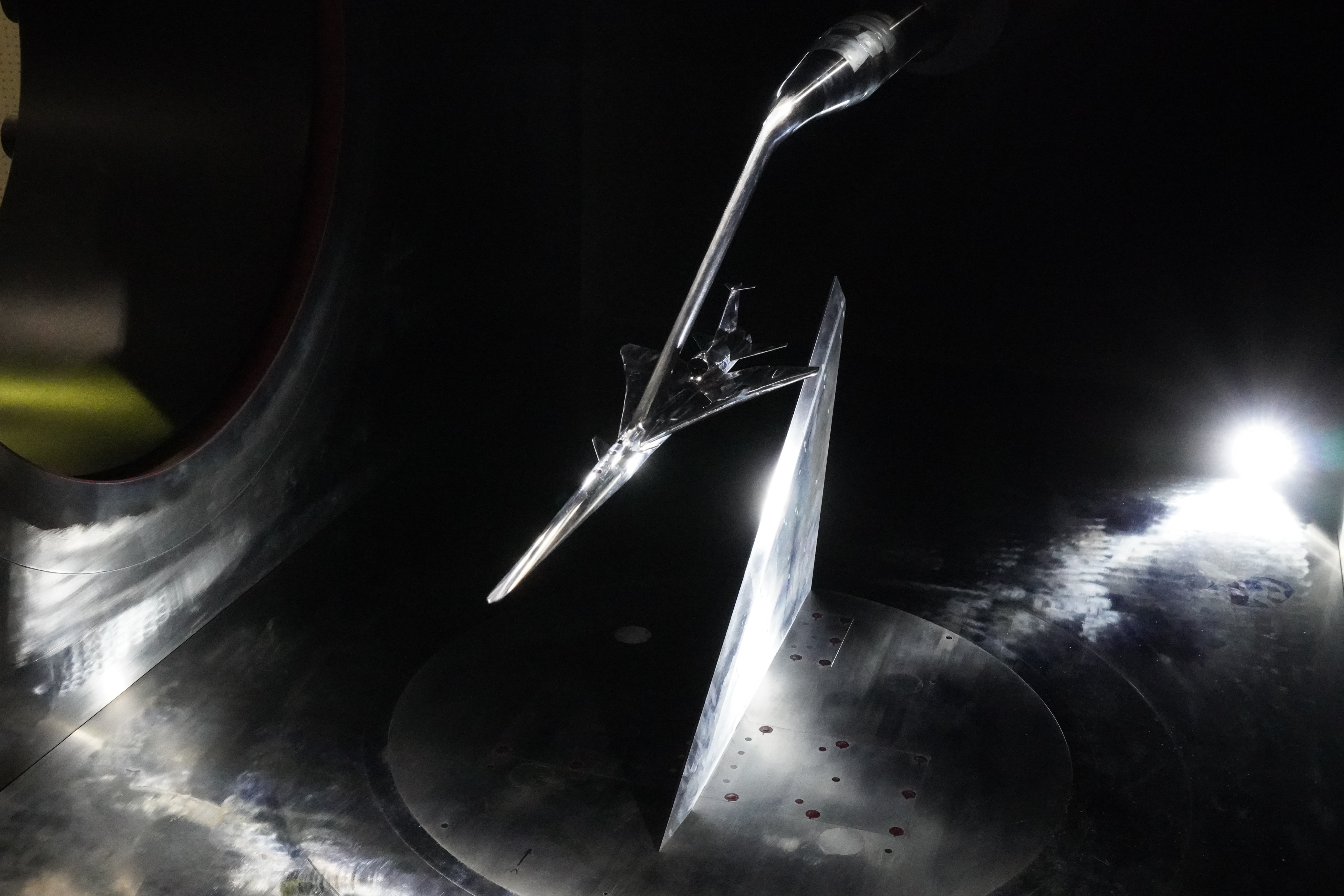
Putting the X-59 to the Test
Putting the X-59 to the Test
Researchers from NASA and the Japanese Aerospace Exploration Agency (JAXA) recently tested a scale model of the X-59 experimental aircraft in a supersonic wind tunnel located in Chofu, Japan, to assess the noise audible underneath the aircraft. The model can be seen in the wind tunnel in this image released on July 11, 2025.
The test was an important milestone for NASA’s one-of-a-kind X-59, which is designed to fly faster than the speed of sound without causing a loud sonic boom. When the X-59 flies, sound underneath it – a result of its pressure signature – will be a critical factor for what people hear on the ground.
This marked the third round of wind tunnel tests for the X-59 model, following a previous test at JAXA and at NASA’s Glenn Research Center in Cleveland. The data will help researchers understand the noise level that will be created by the shock waves the X-59 produces at supersonic speeds.
Image credit: JAXA
