
NASA
Newly Found Organics in Enceladus’ Plumes
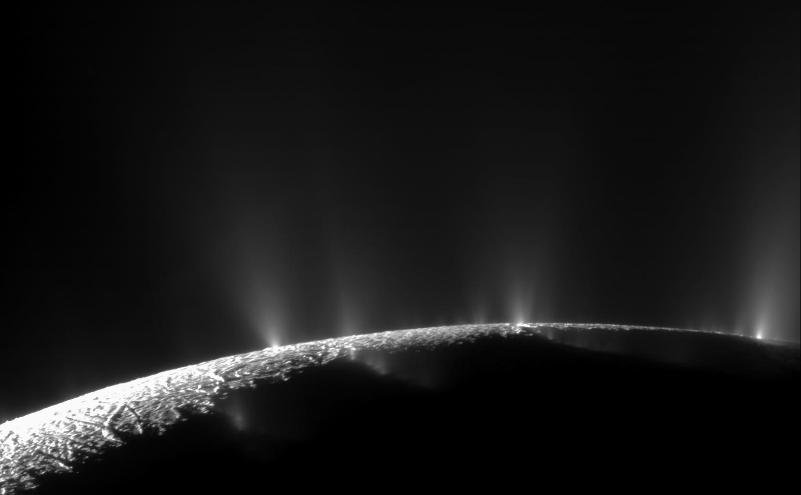
Dramatic plumes, both large and small, spray water ice out from many locations along the famed tiger stripes near the south pole of Saturn’s moon Enceladus in this image released on Feb. 23, 2010. A study published in October 2025 analyzed data from NASA’s Cassini mission and found evidence of previously undetected organic compounds in a plume of ice particles like the ones seen here. The ice particles were ejected from the ocean that lies under Enceladus’ frozen shell. Researchers spotted not only molecules they’ve found before but also new ones that lay a potential path to chemical or biochemical activity.
Learn more about what they discovered.
Image credit: NASA/JPL-Caltech/Space Science Institute
Newly Found Organics in Enceladus’ Plumes
Dramatic plumes, both large and small, spray water ice out from many locations along the famed tiger stripes near the south pole of Saturn’s moon Enceladus in this image released on Feb. 23, 2010. A study published in October 2025 analyzed data from NASA’s Cassini mission and found evidence of previously undetected organic compounds in a plume of ice particles like the ones seen here. The ice particles were ejected from the ocean that lies under Enceladus’ frozen shell. Researchers spotted not only molecules they’ve found before but also new ones that lay a potential path to chemical or biochemical activity.
Learn more about what they discovered.
Image credit: NASA/JPL-Caltech/Space Science Institute
Rings of Rock in the Sahara
In northeastern Africa, within the driest part of the Sahara, dark rocky outcrops rise above pale desert sands. Several of these formations, including Jabal Arakanū, display striking ring-shaped structures.
Jabal Arkanū (also spelled Arkenu) lies in southeastern Libya, near the border with Egypt. Several other massifs are clustered nearby, including Jabal Al Awaynat (or Uweinat), located about 20 kilometers (12 miles) to the southeast. Roughly 90 kilometers to the west are the similarly named Arkenu structures. These circular features were once thought to have formed by meteorite impacts, but later fieldwork suggested they resulted from terrestrial geological processes.
Arkanū’s ring-shaped structures also have an earthly origin. They are thought to have formed as magma rose toward the surface and intruded into the surrounding rock. Repeated intrusion events produced a series of overlapping rings, their centers roughly aligned toward the southwest. The resulting ring complex—composed of igneous basalt and granite—is bordered to the north by a hat-shaped formation made of sandstone, limestone, and quartz layers.
This photograph, taken by an astronaut aboard the International Space Station on September 13, 2025, shows the massif casting long shadows across the desert. The ridges stand nearly 1,400 meters above sea level, or about 800 meters above the surrounding sandy plains. Notice several outwash fans of boulders, gravel, and sand spreading from the mountain’s base toward the bordering longitudinal dunes.
Two wadis, or typically dry riverbeds, wind through the structure. However, water is scarce in this part of the Sahara. Past research using data from NASA and JAXA’s now-completed Tropical Rainfall Measuring Mission (TRMM) indicated that southeastern Libya, along with adjacent regions of Egypt and northern Sudan, receives only about 1 to 5 millimeters of rain per year. Slightly higher accumulations, around 5 to 10 millimeters per year, occur near Jabal Arkanū and neighboring massifs, suggesting a modest orographic effect from the mountains.
Astronaut photograph ISS073-E-698446 was acquired on September 13, 2025, with a Nikon Z9 digital camera using a focal length of 800 millimeters. It is provided by the ISS Crew Earth Observations Facility and the Earth Science and Remote Sensing Unit, Johnson Space Center. The image was taken by a member of the Expedition 73 crew. The image has been cropped and enhanced to improve contrast, and lens artifacts have been removed. The International Space Station Program supports the laboratory as part of the ISS National Lab to help astronauts take pictures of Earth that will be of the greatest value to scientists and the public, and to make those images freely available on the Internet. Additional images taken by astronauts and cosmonauts can be viewed at the NASA/JSC Gateway to Astronaut Photography of Earth. Story by Kathryn Hansen.
References & Resources- Afkareen, M. M., et al. (2022) Lineament Mapping of Jabal Arkenu in Southern Libya. The Scientific Journal of University of Benghazi, 35(1).
- Alghariani, M. (2020) Applications of Remote Sensing for Exploration of Mineral Deposits and Gold in Jabal Arkenu. Fourth International Conference on Geospatial Technologies Libya GeoTec4 in Tripoli – Libya.
- Cigolini, C., et al. (2012) Endogenous and nonimpact origin of the Arkenu circular structures (al-Kufrah basin—SE Libya). Meteoritics & Planetary Science, 47(11), 1772-1788.
- Kelley, O. A. (2014) Where the Least Rainfall Occurs in the Sahara Desert, the TRMM Radar Reveals a Different Pattern of Rainfall Each Season. Journal of Climate, 27(18), 6919–6939.
- NASA Earth Observatory (2024, January 23) Water Beneath the Sand. Accessed October 30, 2025.
- NASA Earth Observatory (2013, March 9) Jebel Uweinat. Accessed October 30, 2025.
- NASA Earth Observatory (2008, November 10) Arkenu Craters, Libya. Accessed October 30, 2025.
JPEG (4.54 MB)
You may also be interested in:
Stay up-to-date with the latest content from NASA as we explore the universe and discover more about our home planet.
Nighttime Over the Eastern Pacific
2 min read
A long-exposure photo taken from low Earth orbit captured the brilliant illumination coming from airglow, lightning, and stars.
ArticleA Northwest Night Awash in Light
3 min read
The glow of city lights, the aurora, and a rising Moon illuminate the night along the northwest coast of North…
ArticleA Halo Above the Horizon
3 min read
A subtle arc, formed by the bending of light through high-altitude ice crystals, cradles the Moon above the darkened Earth.
Article1
2
3
4
Next
Keep Exploring Discover More from NASA Earth Science Subscribe to Earth Observatory Newsletters
Subscribe to the Earth Observatory and get the Earth in your inbox.
Earth Observatory Image of the Day
NASA’s Earth Observatory brings you the Earth, every day, with in-depth stories and stunning imagery.
Explore Earth Science
Earth Science Data
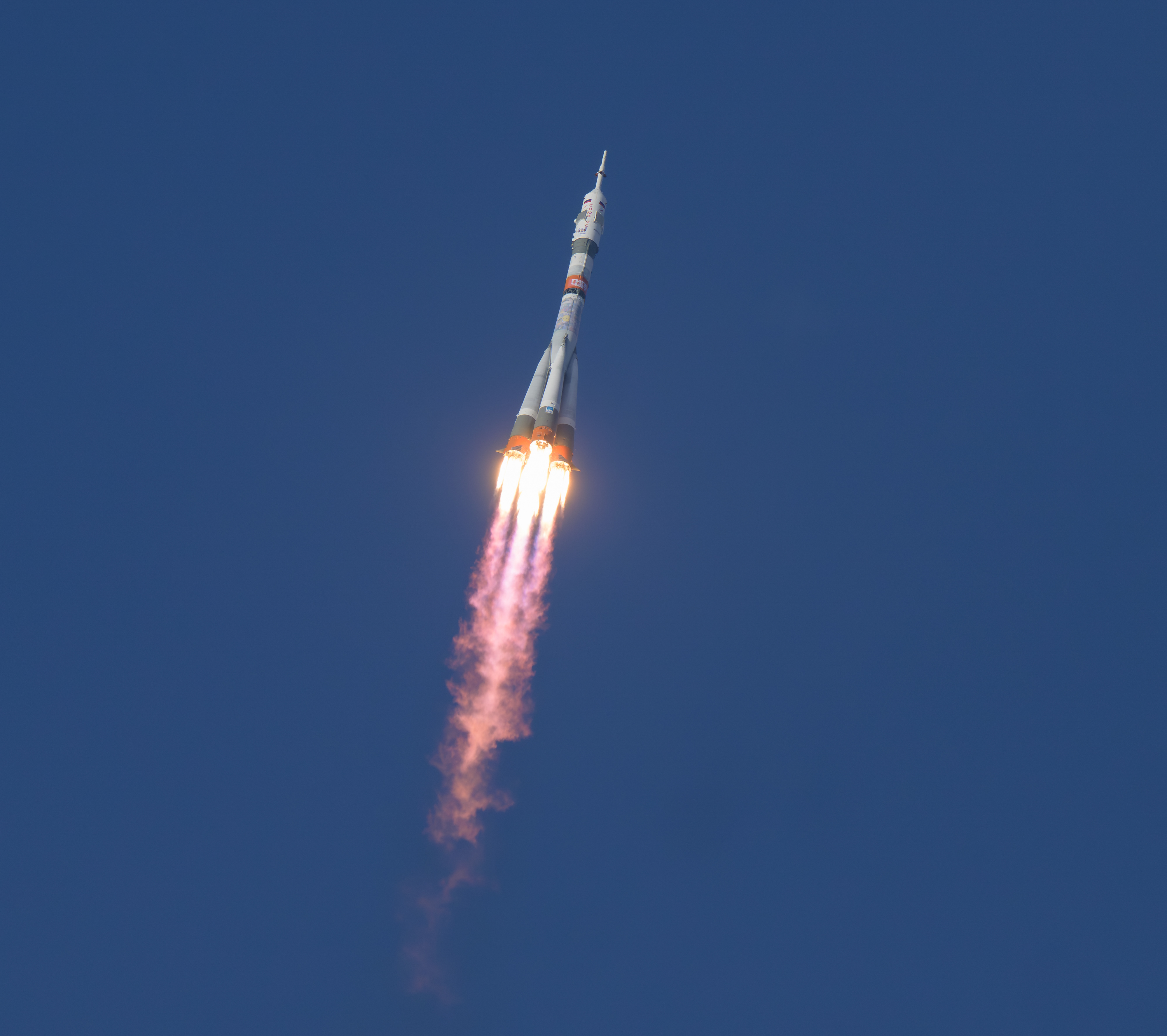
NASA Astronaut Chris Williams, Crewmates Arrive at Space Station
NASA astronaut Chris Williams, accompanied by Roscosmos cosmonauts Sergey Kud-Sverchkov and Sergei Mikaev, safely arrived at the International Space Station on Thursday, expanding the orbiting laboratory’s crew to 10 for the next two weeks.
The trio launched aboard the Soyuz MS-28 spacecraft at 4:27 a.m. EST (2:27 p.m. Baikonur time) from the Baikonur Cosmodrome in Kazakhstan. After a three-hour, two-orbit journey, the spacecraft docked at 7:34 a.m. to the space station’s Rassvet module.
Following hatch opening, expected about 10:10 a.m., the new arrivals will be welcomed by the Expedition 73 crew, including NASA astronauts Mike Fincke, Zena Cardman, and Jonny Kim; JAXA (Japan Aerospace Exploration Agency) astronaut Kimiya Yui; and Roscosmos cosmonauts Sergey Ryzhikov, Alexey Zubritsky, and Oleg Platonov.
NASA’s live coverage of hatch opening begins at 9:50 a.m. on NASA+, Amazon Prime, and YouTube. Learn how to watch NASA content through a variety of platforms, including social media.
During his stay aboard the space station, Williams will conduct scientific research and technology demonstrations aimed at advancing human space exploration and benefiting life on Earth. He will help install and test a new modular workout system for long-duration missions, support experiments to improve cryogenic fuel efficiency and grow semiconductor crystals in space, as well as assist NASA in designing new re-entry safety protocols to protect crews during future missions.
Expedition 74 is scheduled to begin on Monday, Dec. 8, following the departure of Kim, Ryzhikov, and Zubritsky, as they conclude an eight-month science mission aboard the orbital outpost.
Watch the change of command ceremony at 10:25 a.m. on Sunday, Dec. 7, as station leadership transfers from Ryzhikov to Fincke, live on NASA+.
Learn more about International Space Station, crews, research, and operations at:
-end-
Jimi Russell
Headquarters, Washington
202-358-1100
james.j.russell@nasa.gov
Sandra Jones / Joseph Zakrzewski
Johnson Space Center, Houston
281-483-5111
sandra.p.jones@nasa.gov / joseph.a.zakrzewski@nasa.gov
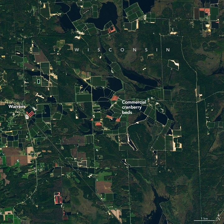
Cranberry Country, Wisconsin
Known as America’s Dairyland, Wisconsin produces the most cheese of any state and trails only California in the production of milk. Less famously, the state outpaces all others in a key part of many Thanksgiving menus. Wisconsin is the leading producer of cranberries in the U.S., with its annual hauls accounting for more than half of the country’s total yield.
The wetlands, cool climate, and sandy, acidic soils of central and northern Wisconsin provide the foundation for raising the tart berry successfully. This satellite image shows geometric networks of cranberry beds alongside small lakes near the town of Warrens, the “Cranberry Capital of Wisconsin.” It was acquired with the OLI-2 (Operational Land Imager-2) on Landsat 9 on October 13, 2025, during the autumn harvest season.
When berries are ripe, growers flood fields with up to a foot of water and then use specialized machines to knock fruit off the vines. Because cranberries contain pockets of air, they float to the surface—turning entire fields red—to be corralled and removed. Beds are not all flooded at once; satellite images acquired throughout the fall show different areas appearing red at different times.
Cranberries are native to Wisconsin marshes, and Native Americans have harvested the fruit for centuries. Commercial production in Wisconsin began in the mid-19th century and expanded as technology and cultivation methods improved. Around 1950, harvesting largely shifted from hand rakes to machines. By 1956, Wisconsin was the second-largest cranberry producer in the U.S. after Massachusetts, and in 1994 it took over the top spot. Today, cranberries in Wisconsin are an approximately $1 billion industry that employs nearly 4,000 people.
In mid-November, as Thanksgiving approaches, the brilliant red berries are on their way to be sold in markets or processed for use in sauces, juices, and other products. Meanwhile, the vines turn deep purple and go dormant. Growers prepare the beds for winter by again flooding the fields to cover plants in a protective layer of ice. They also coat the ice in sand, which will become part of the substrate and rejuvenate growth in the spring. With the right care, a cranberry plant can produce fruit for 50 years or more.
NASA Earth Observatory image by Lauren Dauphin, using Landsat data from the U.S. Geological Survey. Story by Lindsey Doermann.
References & Resources- Esri StoryMaps Mapping the Thanksgiving Harvest. Accessed November 26, 2025.
- NASA Earth Observatory (2022, November 24) Cranberry Bogs in Plymouth County. Accessed November 26, 2025.
- The Old Farmer’s Almanac (2025, October 1) How Cranberries Are Grown, Plus More Fun Facts. Accessed November 26, 2025.
- US Cranberries Cultivation. Accessed November 26, 2025.
- Wisconsin Historical Society Cranberry Farming in Wisconsin – Image Gallery Essay. Accessed November 26, 2025.
- Wisconsin State Cranberry Growers Association (2025) Wisconsin Cranberries. Accessed November 26, 2025.
- Wisconsin State Cranberry Growers Association (2018, May 21) Wisconsin Cranberries: Growing Strong. Accessed November 26, 2025.
JPEG (4.09 MB)
You may also be interested in:
Stay up-to-date with the latest content from NASA as we explore the universe and discover more about our home planet.
Flooding Along the Uruguay and Ibicuí Rivers
3 min read
Astronaut photos captured the aftermath of torrential rainfall in Rio Grande do Sul, Brazil’s southernmost state.
ArticleGreenland Ice Sheet Gets a Refresh
3 min read
A moderately intense season of surface melting left part of the ice sheet dirty gray in summer 2025, but snowfall…
ArticleGreenland’s Bejeweled Ice Sheet
2 min read
In early July 2025, around halfway through the island’s annual melting season, blue meltwater ponds dotted the western side of…
Article1
2
3
4
Next
Keep Exploring Discover More from NASA Earth Science Subscribe to Earth Observatory Newsletters
Subscribe to the Earth Observatory and get the Earth in your inbox.
Earth Observatory Image of the Day
NASA’s Earth Observatory brings you the Earth, every day, with in-depth stories and stunning imagery.
Explore Earth Science
Earth Science Data
PLANETS Units Have Landed – Free NASA-Funded Out-of-School Time Resources
4 min read
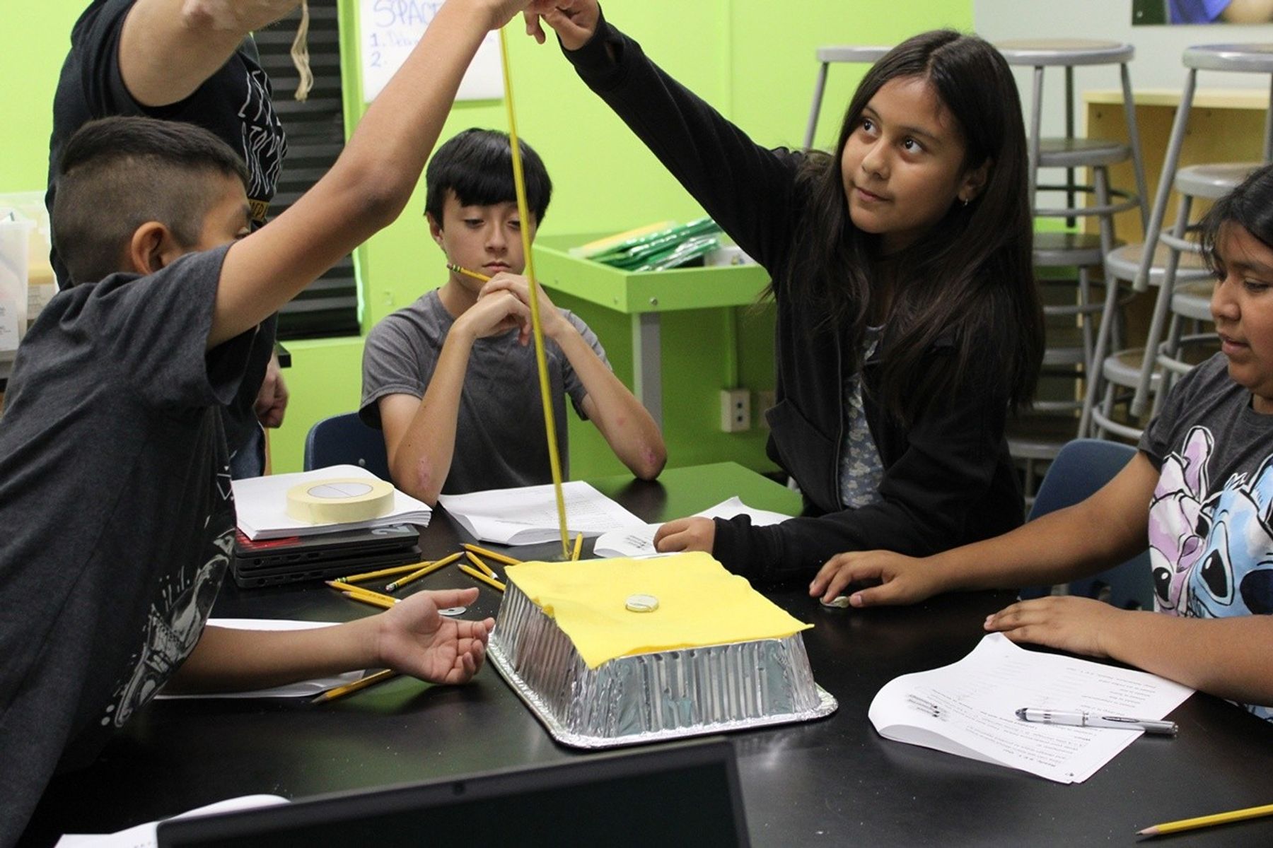
PLANETS Units Have Landed – Free NASA-Funded Out-of-School Time Resources Constructing a three dimensional topographic map from the Remote Sensing Science Pathway.The NASA Science Activation program’s PLANETS (Planetary Learning that Advances the Nexus of Engineering, Technology, and Science) project, led by Northern Arizona University (NAU), is pleased to announce the official launch of three free out-of-school (OST) time units that give all learners in grades 3-5 and 6-8 the chance to do real planetary science and engineering. These units are supported by comprehensive educator guides, videos, and resources.
These three units – Space Hazards, Water in Extreme Environments, and Remote Sensing – have complementary engineering and science pathways that can be taught on their own or together. Subject matter experts in planetary science from the USGS Astrogeology Science Center were involved in every part of developing the activities, working with STEM (Science, Technology, Engineering, & Mathematics) education experts from Northern Arizona University Center for STEM Teaching & Learning, the Boston Museum of Science, and WestEd to ensure the activities are educational, engaging, and accurate.
PLANETS intentionally designed the units to benefit all learners. The curriculum reflects research-based pedagogical strategies, including those for multilingual learners, Indigenous learners, and learners with differing physical abilities. The units have been tested extensively in out-of-school time programs across the country and revised based on their feedback to ensure the needs of all learners are met. PLANETS provides a practical guide for out-of-school time educators with useful advice to effectively teach all students. All units also include educator background on the subject matter, as well as videos, and many useful tips and links to relevant NASA projects and resources.
“PLANETS is one of the most thoughtfully designed STEM resources I’ve used in an out-of-school setting. The hands-on activities are engaging, accessible, and grounded in real-world challenges that spark curiosity in every learner. What sets it apart is the intentional support for diverse learners and the clear, practical guidance for facilitators—making it truly turnkey for OST educators at any experience level. If you’re looking to build STEM identity, teamwork, and creative problem-solving in your program, PLANETS is a must.” ~ Kara Branch, CEO & Founder, Black Girls Do Engineer
In the Space Hazards unit, intended for learners in grades 3-5, students play a card game to learn about how to protect against the different hazards that people face on Earth and that astronauts and robotic probes face in space. The engineering pathway for this unit presents students with a challenge: design a space glove that will keep astronauts safe while still allowing them to do their work.
The Water in Extreme Environments unit is designed for grades 6-8. In the science pathway, students use planet “water cards” to learn where there is the most water in our solar system (hint: it’s not Earth!). The engineering pathway introduces learners to the scarcity of fresh water, both in extreme environments on Earth and for astronauts in space. Students design a filtration system to purify water for reuse.
The engineering pathway for the Remote sensing unit, also designed for grades 6-8, puts students into the shoes of NASA spacecraft engineers, designing remote sensing devices to learn about the surface of planets, like Mars. The science pathway then uses real NASA remote sensing data from Mars landing site candidates to choose the best place to land a rover on Mars.
All PLANETS materials are available at no cost on the website: planets-stem.org. Check them out and empower every learner to see themselves as scientists and engineers.
PLANETS is supported by NASA under cooperative agreement award number NNX16AC53 and is part of NASA’s Science Activation Portfolio. Learn more about how Science Activation connects NASA science experts, real content, and experiences with community leaders to do science in ways that activate minds and promote deeper understanding of our world and beyond: https://science.nasa.gov/learn/about-science-activation/.
Share Details Last Updated Nov 26, 2025 Editor NASA Science Editorial Team Related Terms Explore More 4 min read NASA & GLOBE Connect People, Land, and SpaceArticle
1 day ago
3 min read New NASA HEAT and My NASA Data Resources Bring Space Weather Science into Classrooms
Article
2 days ago
3 min read 10 Years of Students Helping NASA Grow Space Food with Growing Beyond Earth
Article
5 days ago
Keep Exploring Discover More Topics From NASA James Webb Space Telescope
Webb is the premier observatory of the next decade, serving thousands of astronomers worldwide. It studies every phase in the…
Perseverance Rover
This rover and its aerial sidekick were assigned to study the geology of Mars and seek signs of ancient microbial…
Parker Solar Probe
On a mission to “touch the Sun,” NASA’s Parker Solar Probe became the first spacecraft to fly through the corona…
Juno
NASA’s Juno spacecraft entered orbit around Jupiter in 2016, the first explorer to peer below the planet’s dense clouds to…
PLANETS Units Have Landed – Free NASA-Funded Out-of-School Time Resources
4 min read
PLANETS Units Have Landed – Free NASA-Funded Out-of-School Time Resources Constructing a three dimensional topographic map from the Remote Sensing Science Pathway.The NASA Science Activation program’s PLANETS (Planetary Learning that Advances the Nexus of Engineering, Technology, and Science) project, led by Northern Arizona University (NAU), is pleased to announce the official launch of three free out-of-school (OST) time units that give all learners in grades 3-5 and 6-8 the chance to do real planetary science and engineering. These units are supported by comprehensive educator guides, videos, and resources.
These three units – Space Hazards, Water in Extreme Environments, and Remote Sensing – have complementary engineering and science pathways that can be taught on their own or together. Subject matter experts in planetary science from the USGS Astrogeology Science Center were involved in every part of developing the activities, working with STEM (Science, Technology, Engineering, & Mathematics) education experts from Northern Arizona University Center for STEM Teaching & Learning, the Boston Museum of Science, and WestEd to ensure the activities are educational, engaging, and accurate.
PLANETS intentionally designed the units to benefit all learners. The curriculum reflects research-based pedagogical strategies, including those for multilingual learners, Indigenous learners, and learners with differing physical abilities. The units have been tested extensively in out-of-school time programs across the country and revised based on their feedback to ensure the needs of all learners are met. PLANETS provides a practical guide for out-of-school time educators with useful advice to effectively teach all students. All units also include educator background on the subject matter, as well as videos, and many useful tips and links to relevant NASA projects and resources.
“PLANETS is one of the most thoughtfully designed STEM resources I’ve used in an out-of-school setting. The hands-on activities are engaging, accessible, and grounded in real-world challenges that spark curiosity in every learner. What sets it apart is the intentional support for diverse learners and the clear, practical guidance for facilitators—making it truly turnkey for OST educators at any experience level. If you’re looking to build STEM identity, teamwork, and creative problem-solving in your program, PLANETS is a must.” ~ Kara Branch, CEO & Founder, Black Girls Do Engineer
In the Space Hazards unit, intended for learners in grades 3-5, students play a card game to learn about how to protect against the different hazards that people face on Earth and that astronauts and robotic probes face in space. The engineering pathway for this unit presents students with a challenge: design a space glove that will keep astronauts safe while still allowing them to do their work.
The Water in Extreme Environments unit is designed for grades 6-8. In the science pathway, students use planet “water cards” to learn where there is the most water in our solar system (hint: it’s not Earth!). The engineering pathway introduces learners to the scarcity of fresh water, both in extreme environments on Earth and for astronauts in space. Students design a filtration system to purify water for reuse.
The engineering pathway for the Remote sensing unit, also designed for grades 6-8, puts students into the shoes of NASA spacecraft engineers, designing remote sensing devices to learn about the surface of planets, like Mars. The science pathway then uses real NASA remote sensing data from Mars landing site candidates to choose the best place to land a rover on Mars.
All PLANETS materials are available at no cost on the website: planets-stem.org. Check them out and empower every learner to see themselves as scientists and engineers.
PLANETS is supported by NASA under cooperative agreement award number NNX16AC53 and is part of NASA’s Science Activation Portfolio. Learn more about how Science Activation connects NASA science experts, real content, and experiences with community leaders to do science in ways that activate minds and promote deeper understanding of our world and beyond: https://science.nasa.gov/learn/about-science-activation/.
Share Details Last Updated Nov 26, 2025 Editor NASA Science Editorial Team Related Terms Explore More 4 min read NASA & GLOBE Connect People, Land, and SpaceArticle
1 day ago
3 min read New NASA HEAT and My NASA Data Resources Bring Space Weather Science into Classrooms
Article
2 days ago
3 min read 10 Years of Students Helping NASA Grow Space Food with Growing Beyond Earth
Article
5 days ago
Keep Exploring Discover More Topics From NASA James Webb Space Telescope
Webb is the premier observatory of the next decade, serving thousands of astronomers worldwide. It studies every phase in the…
Perseverance Rover
This rover and its aerial sidekick were assigned to study the geology of Mars and seek signs of ancient microbial…
Parker Solar Probe
On a mission to “touch the Sun,” NASA’s Parker Solar Probe became the first spacecraft to fly through the corona…
Juno
NASA’s Juno spacecraft entered orbit around Jupiter in 2016, the first explorer to peer below the planet’s dense clouds to…
Artemis II Orion Spacecraft Stacked
Artemis II Orion Spacecraft Stacked
In this Oct. 20, 2025, photo, NASA’s Artemis II Orion spacecraft with its launch abort system is stacked atop the agency’s SLS (Space Launch System) rocket in the Vehicle Assembly Building at NASA’s Kennedy Space Center in Florida.
Orion will carry NASA astronauts Reid Wiseman, Victor Glover, Christina Koch, and CSA (Canadian Space Agency) astronaut Jeremy Hansen on a 10-day mission around the Moon and back in early 2026.
Follow along with the mission on the NASA Artemis blog.
Image credit: NASA/Kim Shiflett
LSAH Newsletter
1 min read
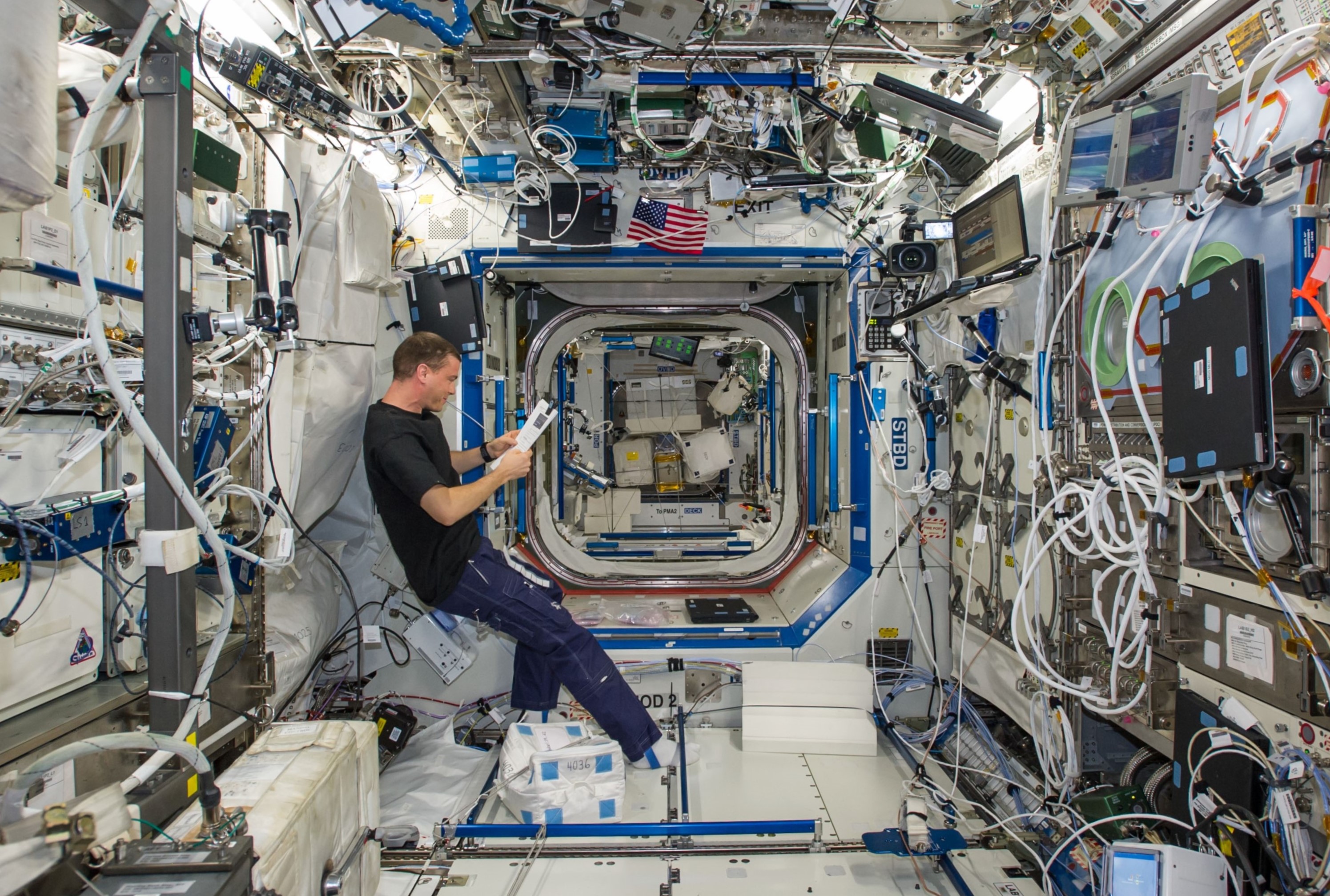
Preparations for Next Moonwalk Simulations Underway (and Underwater) Reid Wiseman finds a little peace and quiet in the station’s Destiny lab.NASAThe Lifetime Surveillance of Astronaut Health (LSAH) program collects, analyzes, and interprets medical, physiological, hazard exposure, and environmental data for the purpose of maintaining astronaut health and safety as well as preventing occupationally induced injuries or disease related to space flight or space flight training. It allows NASA to effectively understand and mitigate the long-term health risks of human spaceflight, as well as support the physical and mental well-being of astronauts during future exploration missions.
The LSAH Newsletter serves to inform and update former astronauts on how their medical data is being utilized by the LSAH team. It is published and distributed bi-annually.
+ October 2025 | Vol 30 Issue 2 – LSAH Newsletter
+ Past LSAH Newsletters and Publications
TREAT Astronauts Act Share Details Last Updated Nov 25, 2025 EditorRobert E. LewisLocationJohnson Space Center Related Terms Explore More 9 min read Medical Examination Requirements (MER) for Former Astronauts Article 3 years ago 1 min read Historical Resources Article 3 years ago 1 min read March Updates for Interim Final Rule, NID, and TAAB Article 3 years ago Keep Exploring Discover More Topics From NASAHumans In Space
Missions
International Space Station
Solar System
LSAH Newsletter
1 min read
Preparations for Next Moonwalk Simulations Underway (and Underwater) Reid Wiseman finds a little peace and quiet in the station’s Destiny lab.NASAThe Lifetime Surveillance of Astronaut Health (LSAH) program collects, analyzes, and interprets medical, physiological, hazard exposure, and environmental data for the purpose of maintaining astronaut health and safety as well as preventing occupationally induced injuries or disease related to space flight or space flight training. It allows NASA to effectively understand and mitigate the long-term health risks of human spaceflight, as well as support the physical and mental well-being of astronauts during future exploration missions.
The LSAH Newsletter serves to inform and update former astronauts on how their medical data is being utilized by the LSAH team. It is published and distributed bi-annually.
+ October 2025 | Vol 30 Issue 2 – LSAH Newsletter
+ Past LSAH Newsletters and Publications
TREAT Astronauts Act Share Details Last Updated Nov 25, 2025 EditorRobert E. LewisLocationJohnson Space Center Related Terms Explore More 9 min read Medical Examination Requirements (MER) for Former Astronauts Article 3 years ago 1 min read Historical Resources Article 3 years ago 1 min read March Updates for Interim Final Rule, NID, and TAAB Article 3 years ago Keep Exploring Discover More Topics From NASAHumans In Space
Missions
International Space Station
Solar System
NASA & GLOBE Connect People, Land, and Space
4 min read
NASA & GLOBE Connect People, Land, and Space The GLOBE Land Cover satellite comparison table is generated weekly for every GLOBE Land Cover observation. GLOBE volunteers receive an email with a link to the table. Information about the table may be found on the GLOBE Observer website.A group of elementary-aged students gather outside of Oldham County Public Library in La Grange, Kentucky, United States to look at clouds in the sky. “If anyone asks what you are doing, tell them, ‘I am a citizen scientist and I am helping NASA,’” Children’s Programming Librarian, Cheri Grinnell, tells the kids. Grinnell supports an afterschool program called Leopard Spot where she engages K-5 students in collecting environmental data with the GLOBE (Global Learning & Observations to Benefit the Environment) Program.
“One little boy really got excited about that, and I heard him tell his mom he was working for NASA as they were leaving,” says Grinnell. That idea is reinforced when the program receives an email from NASA with satellite data that align with the cloud data the students submitted. “I forwarded the NASA satellite response to the after-school coordinator, and she read it to them. That really excited them because it was evidence this is the real deal.”
This experience is one the GLOBE Observer Team (part of the NASA Science Activation program’s NASA Earth Science Education Collaborative, NESEC) hears often: GLOBE volunteers of all ages love getting an email from NASA that compares satellite data with their cloud observations. “Feedback from NASA is huge. It’s the hook,” says Tina Rogerson, the programmer at NASA Langley Research Center who manages the satellite comparison emails. “It ties NASA science into what they saw when they did the observation.”
Now, volunteers will have more opportunities to receive a satellite comparison email from NASA. GLOBE recently announced that, in addition to sending emails about satellite data that align with the cloud observations made by learners, they will now also be sending emails that compare the GLOBE Observer Land Cover observations made by learners with satellite data. The new satellite comparison for land cover builds on the system used to create cloud comparisons at NASA Langley Research Center.
When a volunteer receives the email, they will see a link for each observation they have submitted. The link will open a website with a satellite comparison table. Their observation is at the top, followed by a satellite-based assessment of the land cover at that location. The last row of the table shows the most recent Landsat and Sentinel-2 satellite images of the observation site. Rogerson pulls GLOBE land cover data from the public GLOBE database to generate and send the comparison tables on a weekly basis. While users may opt out of receiving these emails, most participants will be excited to review their data from the space perspective.
These new collocated land cover observations are expected to raise greater awareness of how NASA and its interagency partners observe our changing home planet from space in order to inform societal needs. They will help every GLOBE volunteer see how their observations of the land fit in with the wider space-based view and how they are participating in the process of science. Based on the response to cloud satellite emails, seeing that bigger, impactful perspective via the satellite comparison email is motivating. The hope is to encourage volunteers to continue being NASA citizen scientists, collecting Earth system observations for GLOBE’s long-term environmental record.
“I’m excited that land cover is finally becoming part of the operational satellite comparison system,” says Rogerson. This means that GLOBE volunteers will routinely receive satellite data for both land cover and clouds. “We are bringing real science right into your world.”
NESEC, led by the Institute for Global Environmental Strategies (IGES) and supported by NASA under cooperative agreement award number NNX16AE28A, is part of NASA’s Science Activation Portfolio. Learn more about how Science Activation connects NASA science experts, real content, and experiences with community leaders to do science in ways that activate minds and promote deeper understanding of our world and beyond: https://science.nasa.gov/learn/about-science-activation/.
Share Details Last Updated Nov 25, 2025 Editor NASA Science Editorial Team Related Terms Explore More 3 min read New NASA HEAT and My NASA Data Resources Bring Space Weather Science into ClassroomsArticle
1 day ago
2 min read NASA Citizen Science Toolkit for Librarians
NASA’s Toolkit for Librarians can help you share NASA citizen science opportunities with your patrons…
Article
1 day ago
3 min read 10 Years of Students Helping NASA Grow Space Food with Growing Beyond Earth
Article
4 days ago
Keep Exploring Discover More Topics From NASA James Webb Space Telescope
Webb is the premier observatory of the next decade, serving thousands of astronomers worldwide. It studies every phase in the…
Perseverance Rover
This rover and its aerial sidekick were assigned to study the geology of Mars and seek signs of ancient microbial…
Parker Solar Probe
On a mission to “touch the Sun,” NASA’s Parker Solar Probe became the first spacecraft to fly through the corona…
Juno
NASA’s Juno spacecraft entered orbit around Jupiter in 2016, the first explorer to peer below the planet’s dense clouds to…
