
NASA
Continuing the Quest for Clays
- Perseverance Home
- Science
- News and Features
- Multimedia
- Mars Missions
- Mars Home
3 min read
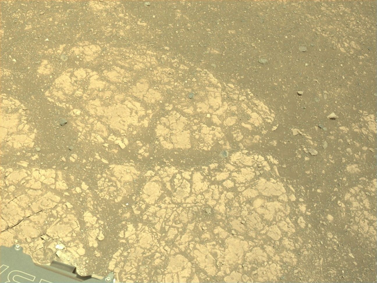
Continuing the Quest for Clays NASA’s Mars Perseverance rover acquired this image showing the target “Jigging Cove,” named by Make-A-Wish participant Madeline, located in the center of the image. Perseverance used its Left Mastcam-Z camera, one of a pair of cameras located high on the rover’s mast, to capture the image on June 27, 2025 (Sol 1547, or Martian day 1,547 of the Mars 2020 mission) at the local mean solar time of 11:26:04. NASA/JPL-Caltech/ASUWritten by Eleanor Moreland, Ph.D. Student Collaborator at Rice University
For the past month and a half, Perseverance has been exploring the Krokodillen plateau in search of clay-bearing rocks. An earlier blog discussed that these rocks could hold clues to Mars’ watery past, and Perseverance has been exploring multiple potential locations to find a suitable target to sample. When a coring target could not be found at the previous outcrop, the Science Team decided to return to the “Main Topsail” locality. In a single drive to this area, Perseverance drove 411.7 meters (1,350.7 feet, or just over a quarter mile) — the longest driving distance ever accomplished by a robotic vehicle on another planet. Go, Percy, go!
Back in the region near “Main Topsail” and “Salmon Point,” the team attempted to abrade and sample the clay-bearing rocks at a few different targets. These rocks, however, are proving very breakable and difficult to sample and abrade. Perseverance has experienced challenging fine-grained rocks before, such as during the fan front campaign inside Jezero crater. In that scenario and this one, the Science and Engineering teams work together diligently to find the highest priority targets and find rocks that could withstand the abrasion and coring processes. In this case, the team has decided to return to the site of a previous abrasion, “Strong Island,” to sample the rock we have already abraded and analyzed. This abrasion showed the strong clay signature the team is looking to sample, and we will make another coring attempt this week.
NASA’s Mars Perseverance rover acquired this image of the target “Gallants,” named by Make-A-Wish participant Joshua, located in the lower left quadrant of the image. Perseverance used its onboard Left Navigation Camera (Navcam), which is located high on the rover’s mast and aids in driving, to capture the image on July 1, 2025 (Sol 1551 or Martian day 1,551 of the Mars 2020 mission), at the local mean solar time of 13:10:08. NASA/JPL-CaltechThis past week, the Perseverance team hosted two very special visitors, Madeline and Joshua, and had the unique honor of fulfilling their wishes through the Make-A-Wish foundation. During their visits to JPL, Madeline and Joshua were named honorary Mars 2020 Operations Team Members. They visited the test rovers in the JPL Mars Yard, watched data arrive from the rover with the Perseverance operations team, and attended a rover planning meeting, collaborating with the science and engineering team members on campus. Madeline and Joshua will forever be connected to the Mars 2020 mission, as each selected the name of one of our planning targets. Madeline’s target, “Jigging Cove,” was a target for Mastcam-Z and SuperCam “all techniques” analysis, including LIBS, VISIR, and RMI. Joshua’s selection, “Gallants,” will be used for the next coring target. Carrying forward the resilience shown by Madeline and Joshua, Perseverance will attempt to sample this clay-rich bedrock before continuing the investigation along the Jezero crater rim.
Share Details Last Updated Jul 08, 2025 Related Terms Explore More 2 min read Curiosity Blog, Sols 4589 – 4592: Setting up to explore Volcán Peña BlancaArticle
21 hours ago
2 min read Curiosity Blog, Sol 4588: Ridges and troughs
Article
22 hours ago
2 min read Curiosity Blog, Sols 4586-4587: Straight Drive, Strategic Science
Article
7 days ago
Keep Exploring Discover More Topics From NASA Mars
Mars is the fourth planet from the Sun, and the seventh largest. It’s the only planet we know of inhabited…
All Mars Resources
Explore this collection of Mars images, videos, resources, PDFs, and toolkits. Discover valuable content designed to inform, educate, and inspire,…
Rover Basics
Each robotic explorer sent to the Red Planet has its own unique capabilities driven by science. Many attributes of a…
Mars Exploration: Science Goals
The key to understanding the past, present or future potential for life on Mars can be found in NASA’s four…
Helio Highlights: May 2025
- Home
- Framework for Heliophysics Education
- Resource Database
- About NASA HEAT
- More
3 min read
Helio Highlights: May 2025 3 Min Read Helio Highlights: May 2025 A satellite image showing the extent of the Northern Lights during part of the Mother’s Day 2024 solar storms. Credits:NOAA One year ago, solar storms lit up the night sky. Why?
The Sun is 93 million miles away from Earth, on average. Even though it’s far away, we can still see and feel its effects here. One of the most beautiful effects are the auroras – colorful lights that dance across the sky near the North and South Poles. These are also called the Northern and Southern Lights. They happen when tiny particles from the Sun hit gas molecules in our atmosphere and give off energy.
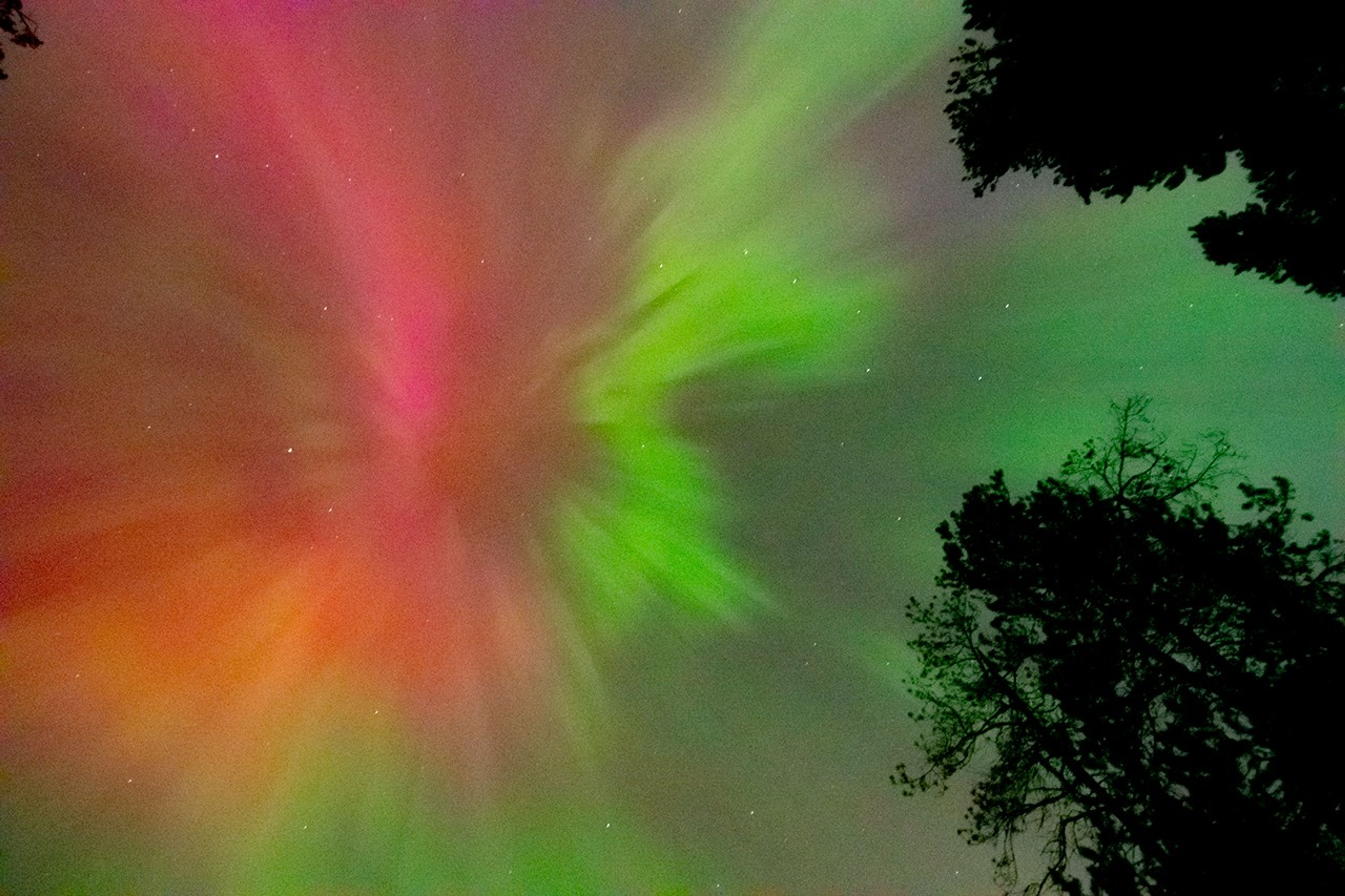
Sometimes the Sun becomes very active and sends out a lot more energy than normal. When this happens, we can see auroras in places much farther from the poles than normal. In May 2024, around Mother’s Day, the Sun sent powerful solar storms in the direction of Earth. These storms were also called the Gannon Storms, named after Jennifer Gannon, a scientist who studied space weather. The Northern Lights could be seen as far south as Puerto Rico, Hawaii, Mexico, Jamaica, and the Bahamas. The Southern Lights were also visible as far north as South Africa and New Zealand.
Aurora Borealis seen from British Columbia, Canada on May 10, 2024. NASA/Mara Johnson-GrohScientists who study the Sun and its effects on our solar system work in a field called heliophysics. Their studies of the Sun have shown that it goes through cycles of being more active and less active. Each one of these cycles lasts about 11 years, but can be anywhere from 8 to 14 years long. This is called the Solar Cycle.
The middle of each cycle is called Solar Maximum. During this time, the Sun has more dark spots (called sunspots) and creates more space weather events. The big storms in May 2024 happened during the Solar Maximum for Solar Cycle 25.
On May 8 and 9, 2024, an active area on the Sun called AR3664 shot out powerful solar flares and several huge bursts of energy called coronal mass ejections (CMEs). These CMEs headed straight for Earth. The first CME pushed aside the normal solar wind, making a clear path for the others to reach us faster. When all this energy hit our atmosphere, it created auroras much farther from the poles than usual. It was like the Sun gave the auroras a huge power boost!
Eruptions of Solar material into space as seen on May 7 (right) and May 8 (left), 2024. These types of eruptions often come just before a larger Coronal Mass Ejection (CME), including the ones which caused the Mother’s Day solar storms. NASA/SDOAuroras are beautiful to watch, but the space weather that creates them can also cause problems. Space weather can mess up radio signals, power grids, GPS systems, and satellites. During the May 2024 storms, GPS systems used by farmers were disrupted. Many farmers use GPS to guide their self-driving tractors. Since this happened during peak planting season, it may have cost billions of dollars in lost profit.
Because space weather can cause so many problems, scientists at NASA and around the world watch the Sun closely to predict when these events will happen. You can help too! Join local science projects at schools, teach others about the Sun, and help make observations in your area. All of this helps us to learn more about the Sun and how it affects our planet.
Here are some resources to connect you to the Sun and auroras Lesson Plans & Educator Guides Magnetic Mysteries: Sun-Earth InteractionsA 5E lesson for high school students to investigate the question of what causes aurora by using Helioviewer to examine solar activity.
Aurora Research and Heliophysics
Learn about aurora, how they form, and the different phases they go through, as well as heliophysics missions that study them.
How Earth’s Magnetic Field Causes Auroras
A 5E middle school lesson where students explore why our planet has a magnetic field (and other planets don’t) and what it is like.
Interactive Resources Magnetic Earth
Introductory activity where users learn about the magnetic field that surrounds Earth and its role in creating the Northern Lights.
NOAA Aurora
30-Minute Forecast
An interactive aurora map for both hemispheres which allows users to predict the likelihood of auroras at different latitudes.
Webinars and Slide Decks Space Weather
Basics
A slide deck (41 slides) that offers an elementary introduction to the basic features of space weather and its interactions with Earth’s magnetosphere and various technologies.
Stellar Duo
Stellar Duo
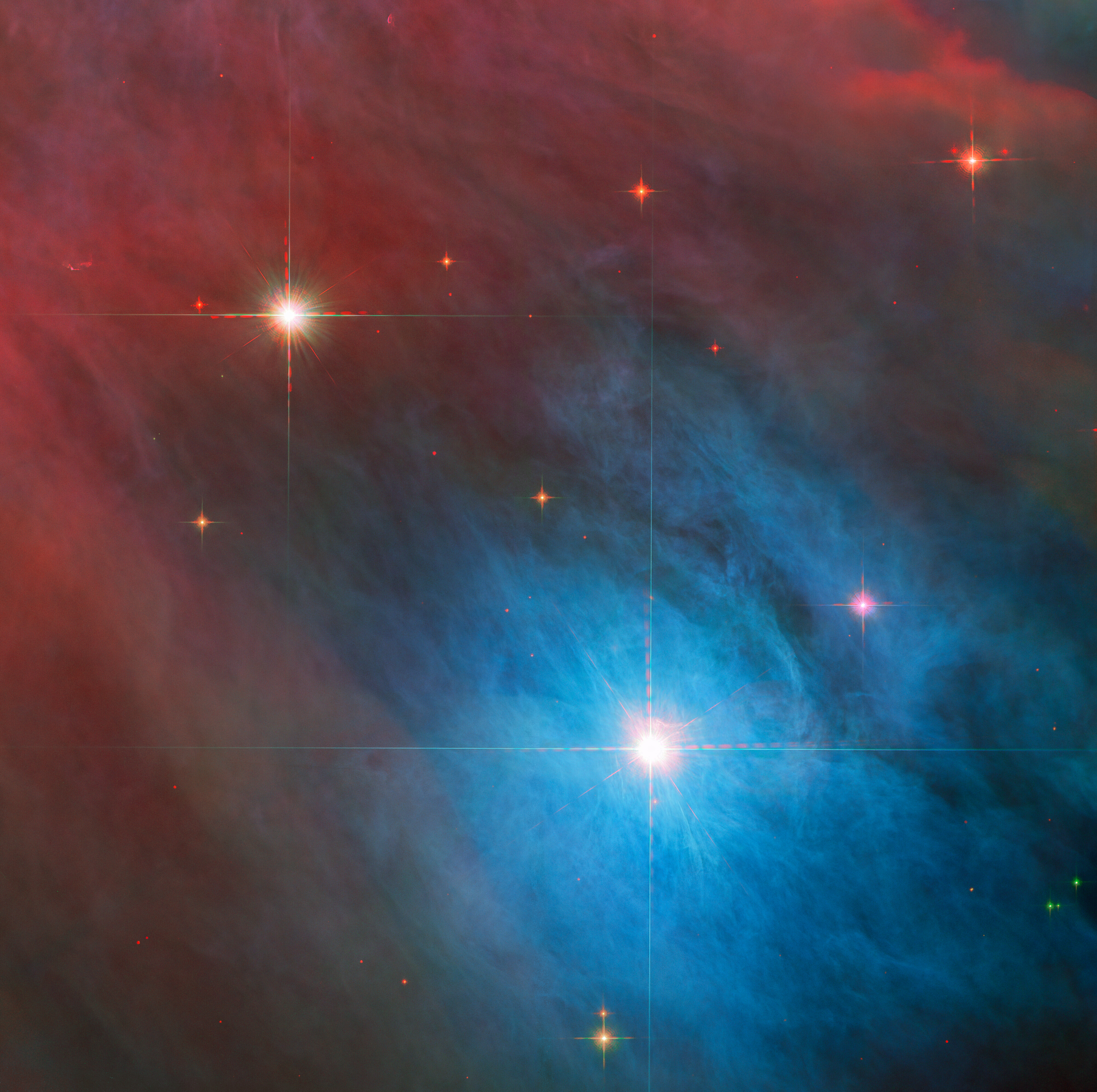
NASA’s Hubble Space Telescope captured a bright variable star, V 372 Orionis, and its companion in this festive image in this image released on Jan. 27, 2023. The pair lie in the Orion Nebula, a colossal region of star formation roughly 1,450 light-years from Earth.
V 372 Orionis is a particular type of variable star known as an Orion Variable. These young stars experience some tempestuous moods and growing pains, which are visible to astronomers as irregular variations in luminosity. Orion Variables are often associated with diffuse nebulae, and V 372 Orionis is no exception; the patchy gas and dust of the Orion Nebula pervade this scene.
Text credit: European Space Agency (ESA)
Image credit: ESA/Hubble & NASA, J. Bally, M. Robberto
Stellar Duo
NASA’s Hubble Space Telescope captured a bright variable star, V 372 Orionis, and its companion in this festive image in this image released on Jan. 27, 2023. The pair lie in the Orion Nebula, a colossal region of star formation roughly 1,450 light-years from Earth.
V 372 Orionis is a particular type of variable star known as an Orion Variable. These young stars experience some tempestuous moods and growing pains, which are visible to astronomers as irregular variations in luminosity. Orion Variables are often associated with diffuse nebulae, and V 372 Orionis is no exception; the patchy gas and dust of the Orion Nebula pervade this scene.
Text credit: European Space Agency (ESA)
Image credit: ESA/Hubble & NASA, J. Bally, M. Robberto
Curiosity Blog, Sols 4589 – 4592: Setting up to explore Volcán Peña Blanca
- Curiosity Home
- Science
- News and Features
- Multimedia
- Mars Missions
- Mars Home
Written by Abigail Fraeman, Deputy Project Scientist at NASA’s Jet Propulsion Laboratory
Earth planning date: Thursday, July 3, 2025
The team was delighted this morning to learn that Wednesday’s drive had completed flawlessly, placing us in a stable position facing a ~3 foot high ridge located ~35 feet away. This ridge is the eastern edge of a feature the team has informally named “Volcán Peña Blanca.” This feature certainly looked intriguing in orbital images, but once we saw Curiosity’s pictures of it from the ground, we decided it was cool enough to spend the time to investigate it closer. The images from the ground show a lot more detail than is visible in orbit, including clear sedimentary structures exposed along the ridge face which could provide important clues about how the rocks in the boxwork-bearing terrain were initially deposited – dunes? Rivers? Lakes? The team picked their favorite spot to approach the ridge and take a closer look during Wednesday’s planning, so Curiosity made a sharp right turn to take us in that direction. Using today’s images, we refined our plan for the exact location to approach and planned a drive to take us there, setting us up for contact science on Monday.
We had the opportunity to plan four sols today, to cover the U.S. 4th of July holiday weekend, so there was lots of time for activities besides the drive. Curiosity is currently sitting right in front of some light toned rocks, including one we gave the evocative name “Huellas de Dinosaurios.” It’s extremely unlikely we’ll see dinosaur footprints in the rock, but we will get the chance to investigate it with APXS, MAHLI, and ChemCam. We also have a pair of ChemCam only targets on a more typical bedrock target named “Amboro” and some pebbles named “Tunari.” Mastcam will take a high resolution of mosaic covering Volcán Peña Blanca, some nearby rocks named “Laguna Verde,” a small light colored rock named “Suruto,” and various patterns in the ground. Two ChemCam RMI mosaics of features in the distant Mishe Mokwa face and environment monitoring activities round out the plan.
For more Curiosity blog posts, visit MSL Mission Updates
Learn more about Curiosity’s science instruments
Explore More 2 min read Curiosity Blog, Sol 4588: Ridges and troughs
Article
2 hours ago
2 min read Curiosity Blog, Sols 4586-4587: Straight Drive, Strategic Science
Article
6 days ago
3 min read An Update From the 2025 Mars 2020 Science Team Meeting
Article
6 days ago
Keep Exploring Discover More Topics From NASA
Mars
Mars Resources
Explore this page for a curated collection of Mars resources.
Rover Basics
Each robotic explorer sent to the Red Planet has its own unique capabilities driven by science. Many attributes of a…
Mars Exploration: Science Goals
The key to understanding the past, present or future potential for life on Mars can be found in NASA’s four…
Curiosity Blog, Sol 4588: Ridges and troughs
- Curiosity Home
- Science
- News and Features
- Multimedia
- Mars Missions
- Mars Home
Written by Lucy Thompson, APXS Collaborator and Senior Research Scientist at the University of New Brunswick, Canada
Earth planning date: Wednesday, July 2, 2025
As we traverse the boxwork terrain, we are encountering a series of more resistant ridges/bedrock patches, and areas that are more rubbly and tend to form lower relief polygonal or trough-like features. We came into planning this morning in one of the trough-like features after another successful drive. The science team is interested in determining why we see these different geomorphological and erosional expressions. Is the rock that comprises the more resistant ridges and patches a different composition to the rock in the troughs and low relief areas? How do the rocks vary texturally? Might the resistant bedrock be an indicator of what we will encounter when we reach the large boxworks that we are driving towards?
We managed to find a large enough area of rock to safely brush (target – “Guapay”), after which we will place APXS and MAHLI to determine the composition and texture. ChemCam will also analyze a different rock target, “Taltal” for chemistry and texture, and we will also acquire an accompanying Mastcam documentation image. The resistant ridge that we are planning to drive towards (“Volcan Pena Blanca”) and eventually investigate will be captured in a Mastcam mosaic. ChemCam will utilize their long-distance imaging capabilities to image the “Mishe Mokwa” butte off to the southeast of our current location, which likely contains bedrock layers that we will eventually pass through as we continue our climb up Mount Sharp.
After a planned drive, taking us closer to the “Volcan Pena Blanca” ridge, MARDI will image the new terrain beneath the wheels, before we execute some atmospheric observations. Mastcam will make a tau observation to monitor dust in the atmosphere and Navcam will acquire a zenith movie. Standard DAN, RAD and REMS activities round out the plan.
For more Curiosity blog posts, visit MSL Mission Updates
Learn more about Curiosity’s science instruments
Explore More 2 min read Curiosity Blog, Sols 4589 – 4592: Setting up to explore Volcán Peña Blanca
Article
44 minutes ago
2 min read Curiosity Blog, Sols 4586-4587: Straight Drive, Strategic Science
Article
6 days ago
3 min read An Update From the 2025 Mars 2020 Science Team Meeting
Article
6 days ago
Keep Exploring Discover More Topics From NASA
Mars
Mars Resources
Explore this page for a curated collection of Mars resources.
Rover Basics
Each robotic explorer sent to the Red Planet has its own unique capabilities driven by science. Many attributes of a…
Mars Exploration: Science Goals
The key to understanding the past, present or future potential for life on Mars can be found in NASA’s four…
Working in Space
Working in Space
In this May 23, 2025, image, NASA astronaut Jonny Kim works inside the SpaceX Dragon cargo spacecraft completing cargo operations before it undocked from the International Space Station’s Harmony module several hours later. Kim launched to the International Space Station on April 8, 2025; this is his first mission.
See what Kim and other space station crew do aboard the orbital lab.
Image credit: NASA; JAXA (Japan Aerospace Exploration Agency)/Takuya Onishi
