
Feed aggregator
Is the bar higher for scientific claims of alien life?
The ups and downs of life in space | On the ISS this week June 23 - 27, 2025
Japan launches GOSAT-GW on 50th and final liftoff of the H-2A rocket (video)
Satellites keep breaking up in space. Insurance won't cover them.
SpaceX sends two batches of Starlink satellites on Saturday doubleheader (video)
A New Way to Detect Primordial Black Holes Through Their Hawking Radiation
Scientists propose a revolutionary new method to detect primordial black holes by hunting for their Hawking radiation. Instead of searching for faint background signals, researchers suggest using the Alpha Magnetic Spectrometer on the International Space Station to watch for distinctive spikes in positron particles as these ancient black holes pass through our solar system, emitting Hawking radiation.
A Statistical Analysis of Exoplanet Habitability Turns Up One Great Candidate - And Significant Observational Bias
The search for life beyond our planet continues, and one of the most underappreciated tools in an astrobiologists' toolkit is statistics. While it might not be as glamorous as directly imaging a planet’s atmosphere or finding a system with seven planets in it, statistics is absolutely critical if we want to be sure that what we’re seeing is real and not just an artifact of the data, or of our observational techniques themselves. A new paper by Caleb Traxler and their co-authors at the Department of Information and Computer Science at UC Irvine takes on that challenge head-on by statistically analyzing a set of about 10% of the total number of exoplanets found and judging their habitability.
The Galactic Center Isn't Spitting Out Stars. What Does This Mean?
Sometimes a non-detection can tell you a lot. For example, astronomers recently searched through data containing around 5 million stars captured by the Dark Energy Spectroscopic Instrument. They were looking for stars that had been ejected from the center of the Milky Way galaxy, through the gravitational interaction of the supermassive black hole Sgr A*. They failed to find any obvious candidates, which suggests that Sgr A* hasn't merged with another black hole recently.
NASA Just Launched A Mission To Calibrate Space-Based Instruments With Moonlight
Calibration is a necessary, if typically invisible, step in the successful operation of any scientific telescope. Without a known value to compare its readings against, data from telescopes could suffer from biases or transients that could completely misdirect scientists analyzing it. However, those same scientists also struggle to find good sources of data to calibrate against. Enter Arcstone - a technology demonstration mission that launched earlier this week that plans to use one particular source as a calibration dataset - moonlight.
Weather Forecasters Lose Crucial Hurricane Detection Microwave Satellite Data
Microwave satellite data are key to capturing major changes in a hurricane’s strength, such as when a storm undergoes rapid intensification. But a main source of those data is being abruptly shut off
Look for the 'Other Dipper' this summer: How to find Ursa Minor, the Little Bear with a little help from the North Star
NASA Welcomes Axiom Mission 4 to the International Space Station
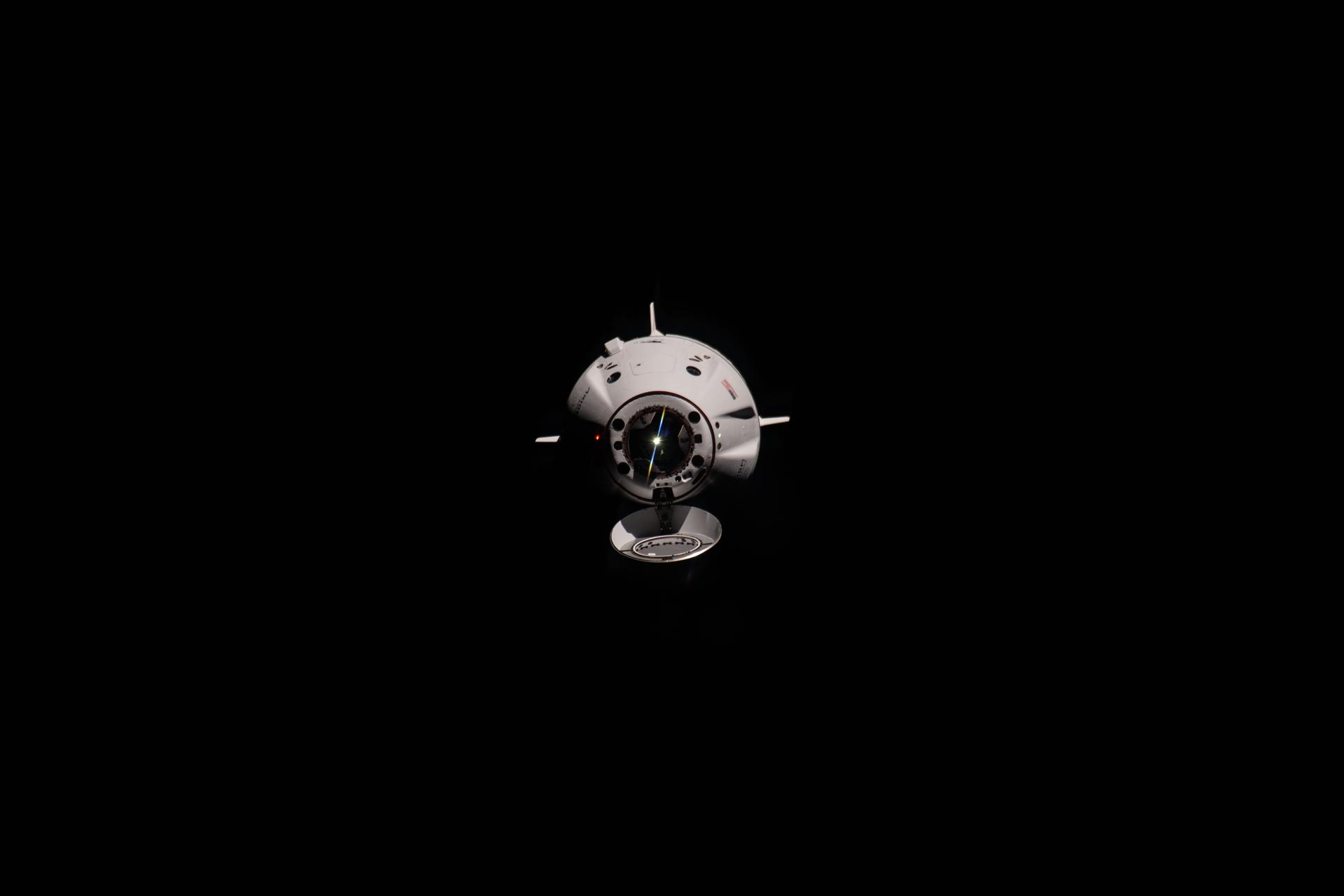
A SpaceX Dragon spacecraft carrying the Axiom Mission 4 crew docks to the space-facing port of the International Space Station’s Harmony module on June 26. Axiom Mission 4 is the fourth all-private astronaut mission to the orbiting laboratory, welcoming commander Peggy Whitson, former NASA astronaut and director of human spaceflight at Axiom Space, ISRO (Indian Space Research Organisation) astronaut and pilot Shubhanshu Shukla, and mission specialists ESA (European Space Agency) project astronaut Sławosz Uznański-Wiśniewski of Poland and HUNOR (Hungarian to Orbit) astronaut Tibor Kapu of Hungary.
The crew is scheduled to remain at the space station, conducting microgravity research, educational outreach, and commercial activities, for about two weeks. This mission serves as an example of the success derived from collaboration between NASA’s international partners and American commercial space companies.
Keep Exploring Discover More Topics From NASALow Earth Orbit Economy
Humans in Space
Commercial Space
Private Astronaut Missions
NASA Welcomes Axiom Mission 4 to the International Space Station
A SpaceX Dragon spacecraft carrying the Axiom Mission 4 crew docks to the space-facing port of the International Space Station’s Harmony module on June 26. Axiom Mission 4 is the fourth all-private astronaut mission to the orbiting laboratory, welcoming commander Peggy Whitson, former NASA astronaut and director of human spaceflight at Axiom Space, ISRO (Indian Space Research Organisation) astronaut and pilot Shubhanshu Shukla, and mission specialists ESA (European Space Agency) project astronaut Sławosz Uznański-Wiśniewski of Poland and HUNOR (Hungarian to Orbit) astronaut Tibor Kapu of Hungary.
The crew is scheduled to remain at the space station, conducting microgravity research, educational outreach, and commercial activities, for about two weeks. This mission serves as an example of the success derived from collaboration between NASA’s international partners and American commercial space companies.
Keep Exploring Discover More Topics From NASALow Earth Orbit Economy
Humans in Space
Commercial Space
Private Astronaut Missions
15 years before Helldivers 2, Lost Planet 2 taught us that the only good bug was a dead bug
NASA Announces Winners of 2025 Human Lander Challenge
NASA’s Human Lander Challenge marked its second year on June 26, awarding $18,000 in prize money to three university teams for their solutions for long-duration cryogenic, or super chilled, liquid storage and transfer systems for spaceflight.
Building on the crewed Artemis II flight test, NASA’s Artemis III mission will send astronauts to explore the lunar South Pole region with a human landing system and advanced spacesuits, preparing humanity to ultimately go to Mars. In-space propulsion systems that use cryogenic liquids as propellants must stay extremely cold to remain in a liquid state and are critical to mission success. The Artemis mission architecture will need these systems to function for several weeks or even months.
Students and advisors with the 12 finalist teams for the 2025 Human Lander Challenge competed in Huntsville, Alabama, near the agency’s Marshall Space Flight Center between June 24-26. NASA/Charles Beason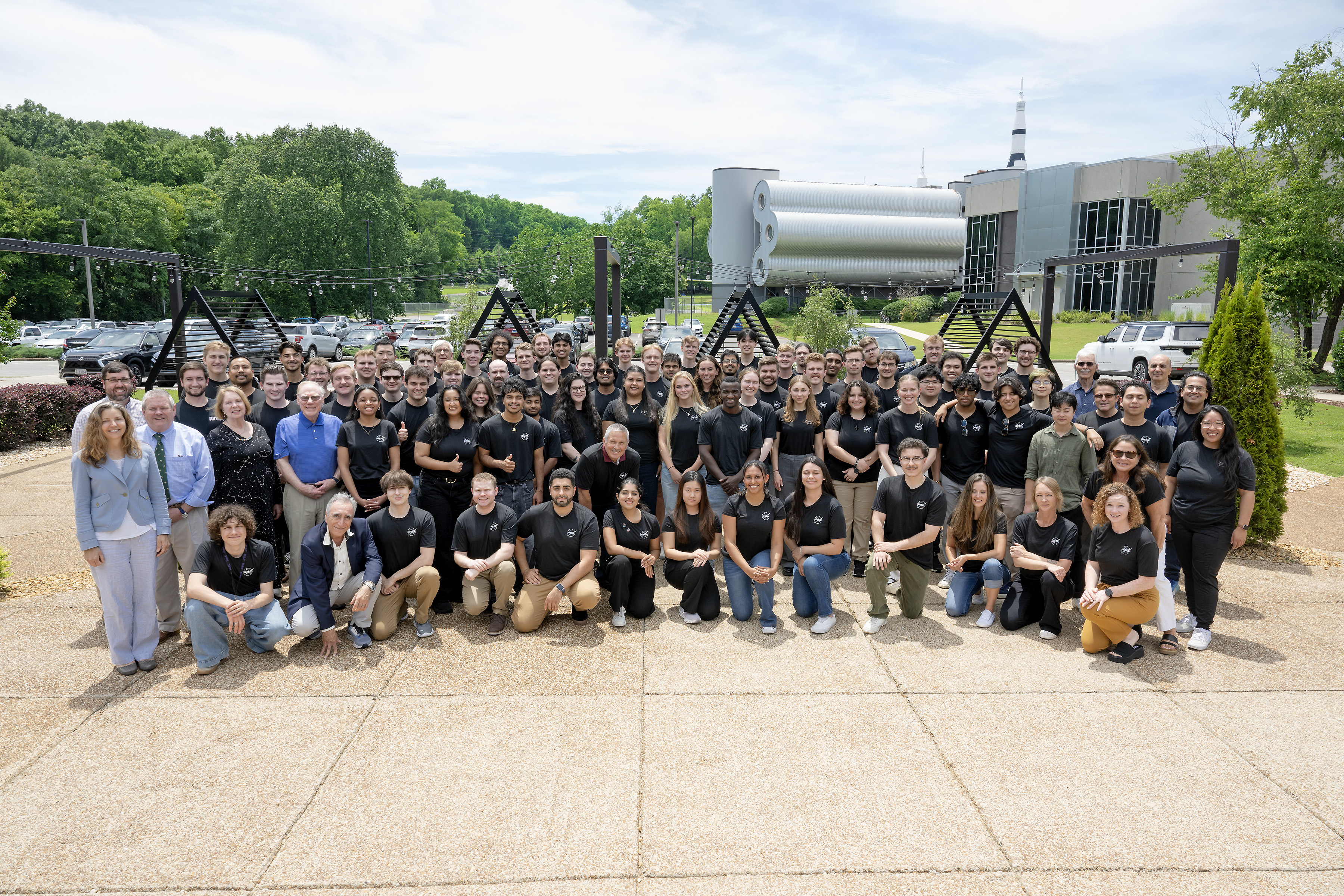
NASA announced Embry-Riddle Aeronautical University, Prescott as the overall winner and recipient of the $10,000 top prize award. Old Dominion University won second place and a $5,000 award, followed by Massachusetts Institute of Technology in third place and a $3,000 award.
Before the winners were announced, 12 finalist teams selected in April gave their presentations to a panel of NASA and industry judges as part of the final competition in Huntsville. As part of the 2025 Human Lander Challenge, university teams developed systems-level solutions that could be used within the next 3-5 years for Artemis.
NASA selected Embry-Riddle Aeronautical University, Prescott as the overall winner of NASA’s 2025 Human Lander Challenge Forum June 26. Lisa Watson-Morgan, manager of NASA’s Human Landing System Program, presented the awards at the ceremony. NASA/Charles Beason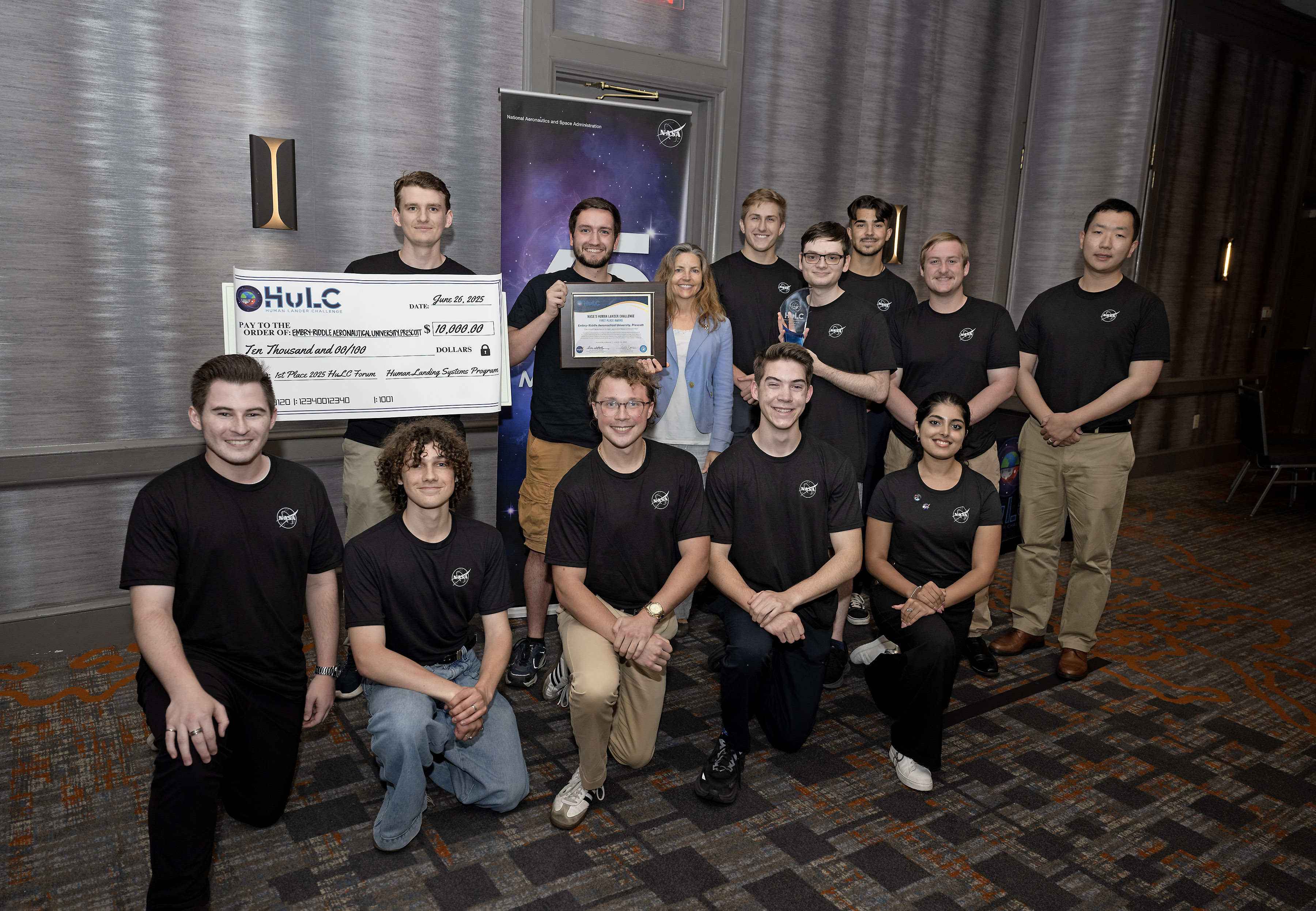
“Today’s Golden Age of Innovation and Exploration students are tomorrow’s mission designers, systems engineers, and explorers,” said Juan Valenzuela, main propulsion systems and cryogenic fluid management subsystems lead for NASA’s Human Landing System Program at NASA’s Marshall Space Flight Center in Huntsville, Alabama. “The Human Lander Challenge concepts at this year’s forum demonstrate the ingenuity, passion, and determination NASA and industry need to help solve long-duration cryogenic storage challenges to advance human exploration to deep space.”
The challenge is sponsored by the agency’s Human Landing System Program within the Exploration Systems Development Mission Directorate and managed by the National Institute of Aerospace.
Through the Artemis campaign, NASA will send astronauts to explore the Moon for scientific discovery, economic benefits, and to build the foundation for the first crewed missions to Mars – for the benefit of all.
For more information about Artemis missions, visit:
News Media ContactCorinne Beckinger
Marshall Space Flight Center, Huntsville, Ala.
256.544.0034
corinne.m.beckinger@nasa.gov
Human Landing System
Space Launch System (SLS)Marshall Space Flight Center manages the Space Launch System (SLS), an integrated super heavy lift launch platform enabling a new…
Humans In Space
Orion CapsuleNASA’s Orion spacecraft is built to take humans farther than they’ve ever gone before. Orion will serve as the exploration…
NASA Announces Winners of 2025 Human Lander Challenge
NASA’s Human Lander Challenge marked its second year on June 26, awarding $18,000 in prize money to three university teams for their solutions for long-duration cryogenic, or super chilled, liquid storage and transfer systems for spaceflight.
Building on the crewed Artemis II flight test, NASA’s Artemis III mission will send astronauts to explore the lunar South Pole region with a human landing system and advanced spacesuits, preparing humanity to ultimately go to Mars. In-space propulsion systems that use cryogenic liquids as propellants must stay extremely cold to remain in a liquid state and are critical to mission success. The Artemis mission architecture will need these systems to function for several weeks or even months.
Students and advisors with the 12 finalist teams for the 2025 Human Lander Challenge competed in Huntsville, Alabama, near the agency’s Marshall Space Flight Center between June 24-26. NASA/Charles BeasonNASA announced Embry-Riddle Aeronautical University, Prescott as the overall winner and recipient of the $10,000 top prize award. Old Dominion University won second place and a $5,000 award, followed by Massachusetts Institute of Technology in third place and a $3,000 award.
Before the winners were announced, 12 finalist teams selected in April gave their presentations to a panel of NASA and industry judges as part of the final competition in Huntsville. As part of the 2025 Human Lander Challenge, university teams developed systems-level solutions that could be used within the next 3-5 years for Artemis.
NASA selected Embry-Riddle Aeronautical University, Prescott as the overall winner of NASA’s 2025 Human Lander Challenge Forum June 26. Lisa Watson-Morgan, manager of NASA’s Human Landing System Program, presented the awards at the ceremony. NASA/Charles Beason“Today’s Golden Age of Innovation and Exploration students are tomorrow’s mission designers, systems engineers, and explorers,” said Juan Valenzuela, main propulsion systems and cryogenic fluid management subsystems lead for NASA’s Human Landing System Program at NASA’s Marshall Space Flight Center in Huntsville, Alabama. “The Human Lander Challenge concepts at this year’s forum demonstrate the ingenuity, passion, and determination NASA and industry need to help solve long-duration cryogenic storage challenges to advance human exploration to deep space.”
The challenge is sponsored by the agency’s Human Landing System Program within the Exploration Systems Development Mission Directorate and managed by the National Institute of Aerospace.
Through the Artemis campaign, NASA will send astronauts to explore the Moon for scientific discovery, economic benefits, and to build the foundation for the first crewed missions to Mars – for the benefit of all.
For more information about Artemis missions, visit:
News Media ContactCorinne Beckinger
Marshall Space Flight Center, Huntsville, Ala.
256.544.0034
corinne.m.beckinger@nasa.gov
Human Landing System
Space Launch System (SLS)Marshall Space Flight Center manages the Space Launch System (SLS), an integrated super heavy lift launch platform enabling a new…
Humans In Space
Orion CapsuleNASA’s Orion spacecraft is built to take humans farther than they’ve ever gone before. Orion will serve as the exploration…
Schweickart Prize Goes to a Plan for Managing Asteroid Mining Risks
This year's $10,000 Schweickart Prize is going to a team of students who are proposing a panel to address the risks that could arise when we start tinkering with asteroids.
Webb Should Be Able to Detect Exo-Jupiters and Exo-Saturns
JWST is a powerful telescope and has directly observed a handful of exoplanets. But according to a new paper, it could set its sights higher, way higher. Astronomers suggest that Webb's MIRI and NIRCam instruments have the capabilities to detect planets around nearby stars as cold (or colder) than Saturn, at the same orbital separation, mass, and age as Saturn and Jupiter. They also found that clouds can have a big impact on their ability to study the planets, but it's easier for MIRI.