
Feed aggregator
SpaceX Falcon 9 rocket launches Starlink satellites on record-breaking 30th flight (video)
Izaña-2 joins the laser game to track space debris
In Tenerife, Spain, stands a unique duo: ESA’s Izaña-1 and Izaña-2 laser-ranging stations. Together, they form an optical technology testbed of the European Space Agency that takes the monitoring of space debris and satellites to a new level while maturing new technologies for commercialisation.
Space debris is a threat to satellites and is rapidly becoming a daily concern for satellite operators. The Space Safety Programme, part of ESA Operations, managed from ESOC in Germany, helps develop new technologies to detect and track debris, and to prevent collisions in orbit in new and innovative ways.
One of these efforts takes place at the Izaña station in Tenerife. There, ESA and partner companies are testing how to deliver precise orbit data on demand with laser-based technologies. The Izaña-2 station was recently finalised by the German company DiGOS and is now in use.
To perform space debris laser ranging, Izaña-2 operates as a laser transmitter, emitting high-power laser pulses towards objects in space. Izaña-1 then acts as the receiver of the few photons that are reflected back. The precision of the laser technology enables highly accurate data for precise orbit determination, which in turn is crucial for actionable collision avoidance systems and sustainable space traffic management.
With the OMLET (Orbital Maintenance via Laser momEntum Transfer) project, ESA combines different development streams and possibilities for automation to support European industry with getting two innovative services market-ready: on-demand ephemeris provision and laser-based collision avoidance services for end users such as satellite operators.
A future goal is to achieve collision avoidance by laser momentum transfer, where instead of the operational satellite, the piece of debris will be moved out of the way. This involves altering the orbit of a piece of space debris slightly by applying a small force to the object through laser illumination.
The European Space Agency actively supports European industry in capitalising on the business opportunities that not only safeguard our satellites but also pave the way for the sustainable use of space.
A Promising New Method for Detecting Supernovae at Record Speed
A new study led by the Institute of Space Sciences (ICE-CSIC) in Barcelona presents a new method and protocol for detecting supernovae within days. Their findings are crucial to astronomers hoping to learn more about these powerful events and the life cycles of stars.
New Study Rocks Jupiter's Giant Impact Theory
Scientists thought they had Jupiter figured out until NASA's Juno spacecraft peered inside our Solar System’s largest planet and discovered something completely unexpected. Jupiter doesn't have the solid, well defined core that researchers had imagined, instead, Jupiter's core is mysteriously fuzzy and blurred, defying everything we thought we knew about how giant planets form. Now, powerful computer simulations are overturning the leading theory about how this strange structure came to be, suggesting that Jupiter's secrets run deeper than anyone realised.
Space Rocks Tell Tale of Shared Ancient Past
Asteroids floating through our Solar System are debris left over from when our planetary neighbourhood formed 4.6 billion years ago. Scientists study these ancient fragments as time capsules that reveal secrets about our Solar System's earliest days. Now, new research has uncovered a surprising connection between two completely different types of asteroids that may actually share the same dramatic origin story.
Roman Space Telescope Joins Earth's Asteroid Defence Team
When NASA's Nancy Grace Roman Space Telescope launches in October 2026, it won't just be peering into the distant universe to study dark energy and exoplanets. This powerful observatory will also serve as Earth's newest guardian, helping scientists track and understand potentially dangerous asteroids and comets that could threaten our planet.
Over Soroya Ridge & Onward!
- Perseverance Home
- Science
- News and Features
- Multimedia
- Mars Missions
- Mars Home
Written by Eleanor Moreland, Ph.D. Student Collaborator at Rice University
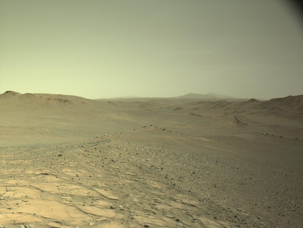
Perseverance has continued exploring beyond the rim of Jezero crater, spending time last week at Parnasset conducting a mini-campaign on aeolian bedforms. After wrapping up that work, three separate drives brought Perseverance further southeast to an outcrop named Soroya.
Soroya was first picked out from orbital images as a target of interest because, as can be seen in the above image, it appears as a much lighter color compared to the surroundings. In previous landscape images from the surface, Mars 2020 scientists have been able to pick out the light-toned Soryoa outcrop, and they noted it forms a ridge-like structure, protruding above the surface. Soroya was easily identifiable from rover images (below) as Perseverance approached since it indeed rises above the surrounding low-lying terrain.
The Perseverance rover acquired this image looking at Soroya using the onboard Left Navigation Camera (Navcam). This image was acquired on Aug. 15, 2025 (Sol 1595) at the local mean solar time of 16:34:53. NASA/JPL-Caltech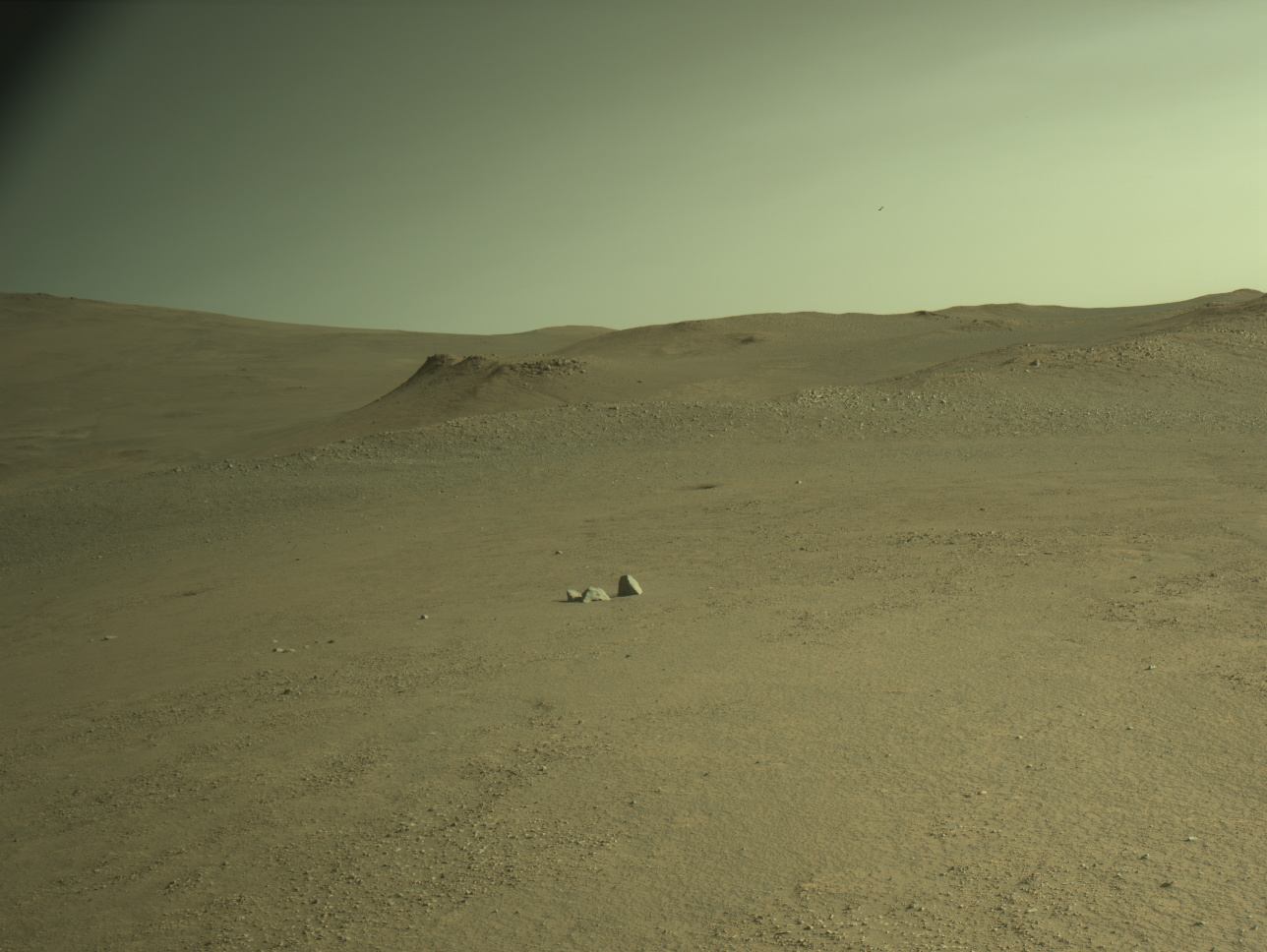
From Parnasset to Soroya, the team planned a series of drives so that Perseverance would arrive at Soroya in a great workspace, and the plan was successful. As shown in the first image, we arrived at an area with flat, exposed bedrock – great for proximity science instruments.
The WATSON and SHERLOC ACI cameras plan to acquire many high-resolution images to investigate textures and surface features. For chemistry, SCAM LIBS and ZCAM multispectral activities will give important contextual data for the outcrop while PIXL will acquire a high-resolution chemical map scan of a dust-cleared part of the bedrock. While parked, MEDA will continue monitoring environmental conditions and ZCAM will image the surrounding terrain to inform the next drive location. Take a look at where Perseverance is now – where would you explore next?
-
Want to read more posts from the Perseverance team?
-
Want to learn more about Perseverance’s science instruments?
Article
2 days ago
3 min read To See the World in a Grain of Sand: Investigating Megaripples at ‘Kerrlaguna’
Article
6 days ago
2 min read Curiosity Blog, Sols 4636-4637: Up Against a Wall
Article
7 days ago
Keep Exploring Discover More Topics From NASA Current Mars Investigations
Current Mars Investigations The weather and climate of Mars are controlled by the coupled seasonal cycles of CO2, dust, and…
All Mars Resources
Explore this collection of Mars images, videos, resources, PDFs, and toolkits. Discover valuable content designed to inform, educate, and inspire,…
Rover Basics
Each robotic explorer sent to the Red Planet has its own unique capabilities driven by science. Many attributes of a…
Mars Exploration: Science Goals
The key to understanding the past, present or future potential for life on Mars can be found in NASA’s four…
Over Soroya Ridge & Onward!
- Perseverance Home
- Science
- News and Features
- Multimedia
- Mars Missions
- Mars Home
Written by Eleanor Moreland, Ph.D. Student Collaborator at Rice University
Perseverance has continued exploring beyond the rim of Jezero crater, spending time last week at Parnasset conducting a mini-campaign on aeolian bedforms. After wrapping up that work, three separate drives brought Perseverance further southeast to an outcrop named Soroya.
Soroya was first picked out from orbital images as a target of interest because, as can be seen in the above image, it appears as a much lighter color compared to the surroundings. In previous landscape images from the surface, Mars 2020 scientists have been able to pick out the light-toned Soryoa outcrop, and they noted it forms a ridge-like structure, protruding above the surface. Soroya was easily identifiable from rover images (below) as Perseverance approached since it indeed rises above the surrounding low-lying terrain.
The Perseverance rover acquired this image looking at Soroya using the onboard Left Navigation Camera (Navcam). This image was acquired on Aug. 15, 2025 (Sol 1595) at the local mean solar time of 16:34:53. NASA/JPL-CaltechFrom Parnasset to Soroya, the team planned a series of drives so that Perseverance would arrive at Soroya in a great workspace, and the plan was successful. As shown in the first image, we arrived at an area with flat, exposed bedrock – great for proximity science instruments.
The WATSON and SHERLOC ACI cameras plan to acquire many high-resolution images to investigate textures and surface features. For chemistry, SCAM LIBS and ZCAM multispectral activities will give important contextual data for the outcrop while PIXL will acquire a high-resolution chemical map scan of a dust-cleared part of the bedrock. While parked, MEDA will continue monitoring environmental conditions and ZCAM will image the surrounding terrain to inform the next drive location. Take a look at where Perseverance is now – where would you explore next?
-
Want to read more posts from the Perseverance team?
-
Want to learn more about Perseverance’s science instruments?
Article
2 days ago
3 min read To See the World in a Grain of Sand: Investigating Megaripples at ‘Kerrlaguna’
Article
6 days ago
2 min read Curiosity Blog, Sols 4636-4637: Up Against a Wall
Article
7 days ago
Keep Exploring Discover More Topics From NASA Current Mars Investigations
Current Mars Investigations The weather and climate of Mars are controlled by the coupled seasonal cycles of CO2, dust, and…
All Mars Resources
Explore this collection of Mars images, videos, resources, PDFs, and toolkits. Discover valuable content designed to inform, educate, and inspire,…
Rover Basics
Each robotic explorer sent to the Red Planet has its own unique capabilities driven by science. Many attributes of a…
Mars Exploration: Science Goals
The key to understanding the past, present or future potential for life on Mars can be found in NASA’s four…
Who Is Eligible for the COVID Vaccine in 2025, and How to Get It
Many questions still surround COVID vaccine access this fall, but here’s what we know so far
'A remarkable discovery': Astronomers find 1st exoplanet in multi-ring disk around star
'If ever there's a movie where I got everything right, it was 'Alien': How Oscar winner Roger Christian made 'Alien: Earth' feel like a classic (exclusive)
See the First Complete Map of a Mammal’s Peripheral Nervous System in Stunning Detail
This new “connectome” could bring researchers one step closer to understanding how nerves connect to organs throughout the body
Patagonia Glacier retreat, Chile
- Earth
- Explore
- Science at Work
- Multimedia
- Data
- For Researchers
- About Us
before after
Patagonia, Chile. Left: September 18, 1986. Right: August 5, 2002. The 1986 image shows the region prior to a major retreat of the glaciers. The 2002 image shows a retreat of nearly 10 kilometers (6.2 miles) of the glacier on the left side. The smaller glacier on the right has receded more than 2 kilometers (1.2 miles). In front of the smaller glacier, two ribbon lakes have formed behind the debris left by the glacier’s advance. Scientists and government managers are using satellite imagery like this to monitor the retreat of the glaciers and the impact on water bodies caused by the changes in the glaciers’ size and direction. Left image taken by the Thematic Mapper sensor onboard Landsat 5. Right image taken by the Enhanced Thematic Mapper Plus sensor onboard Landsat 7. Source: USGS Landsat Missions Gallery, “Patagonia Region – Retreating Glaciers,” U.S. Department of the Interior / U.S. Geological Survey. NASA/USGS
Patagonia, Chile. Left: September 18, 1986. Right: August 5, 2002. The 1986 image shows the region prior to a major retreat of the glaciers. The 2002 image shows a retreat of nearly 10 kilometers (6.2 miles) of the glacier on the left side. The smaller glacier on the right has receded more than 2 kilometers (1.2 miles). In front of the smaller glacier, two ribbon lakes have formed behind the debris left by the glacier’s advance. Scientists and government managers are using satellite imagery like this to monitor the retreat of the glaciers and the impact on water bodies caused by the changes in the glaciers’ size and direction. Left image taken by the Thematic Mapper sensor onboard Landsat 5. Right image taken by the Enhanced Thematic Mapper Plus sensor onboard Landsat 7. Source: USGS Landsat Missions Gallery, “Patagonia Region – Retreating Glaciers,” U.S. Department of the Interior / U.S. Geological Survey. NASA/USGS beforeafter
Before and After
Patagonia Glacier retreat, ChileSeptember 18, 1986 – August 5, 2002
CurtainToggle
Image Details
Patagonia, Chile. Left: September 18, 1986. Right: August 5, 2002. The 1986 image shows the region prior to a major retreat of the glaciers. The 2002 image shows a retreat of nearly 10 kilometers (6.2 miles) of the glacier on the left side. The smaller glacier on the right has receded more than 2 kilometers (1.2 miles). In front of the smaller glacier, two ribbon lakes have formed behind the debris left by the glacier’s advance. Scientists and government managers are using satellite imagery like this to monitor the retreat of the glaciers and the impact on water bodies caused by the changes in the glaciers’ size and direction. Left image taken by the Thematic Mapper sensor onboard Landsat 5. Right image taken by the Enhanced Thematic Mapper Plus sensor onboard Landsat 7. Source: USGS Landsat Missions Gallery, “Patagonia Region – Retreating Glaciers,” U.S. Department of the Interior / U.S. Geological Survey.
Downloads
Image 1
JPEG
(3 MB)
Image 2
JPEG
(3 MB)
Keep Exploring
Explore Earth Science
Earth Science Missions
In order to study the Earth as a whole system and understand how it is changing, NASA develops and supports…
Earth Science at Work
NASA Earth Science helps Americans respond to challenges and societal needs — such as wildland fires, hurricanes, and water supplies…
Earth Science Data