
Feed aggregator
A single dose of LSD seems to reduce anxiety
A single dose of LSD seems to reduce anxiety
SpaceX Dragon cargo capsule boosts ISS higher above Earth in key test
NASA, Northrop Grumman to Send Medical, Technology Studies to Space
NASA and Northrop Grumman are preparing to send the company’s next cargo mission to the International Space Station, flying research to support Artemis missions to the Moon and human exploration of Mars and beyond, while improving life on Earth. SpaceX’s Falcon 9 rocket will launch Northrop Grumman’s 23rd commercial resupply services mission to the orbiting laboratory.
The investigations aboard the Cygnus spacecraft aim to refine semiconductor crystals for next-generation technologies, reduce harmful microbes, improve medication production, and manage fuel pressure.
NASA, Northrop Grumman, and SpaceX are targeting launch in mid-September from Space Launch Complex 40 at Cape Canaveral Space Force Station in Florida.
Read about some of the investigations traveling to the space station:
Better semiconductor crystals Optical micrograph of a semiconductor composite wafer with embedded semimetal phases extracted from a space grown crystal in the SUBSA facility during Mission 1United Semiconductors LLC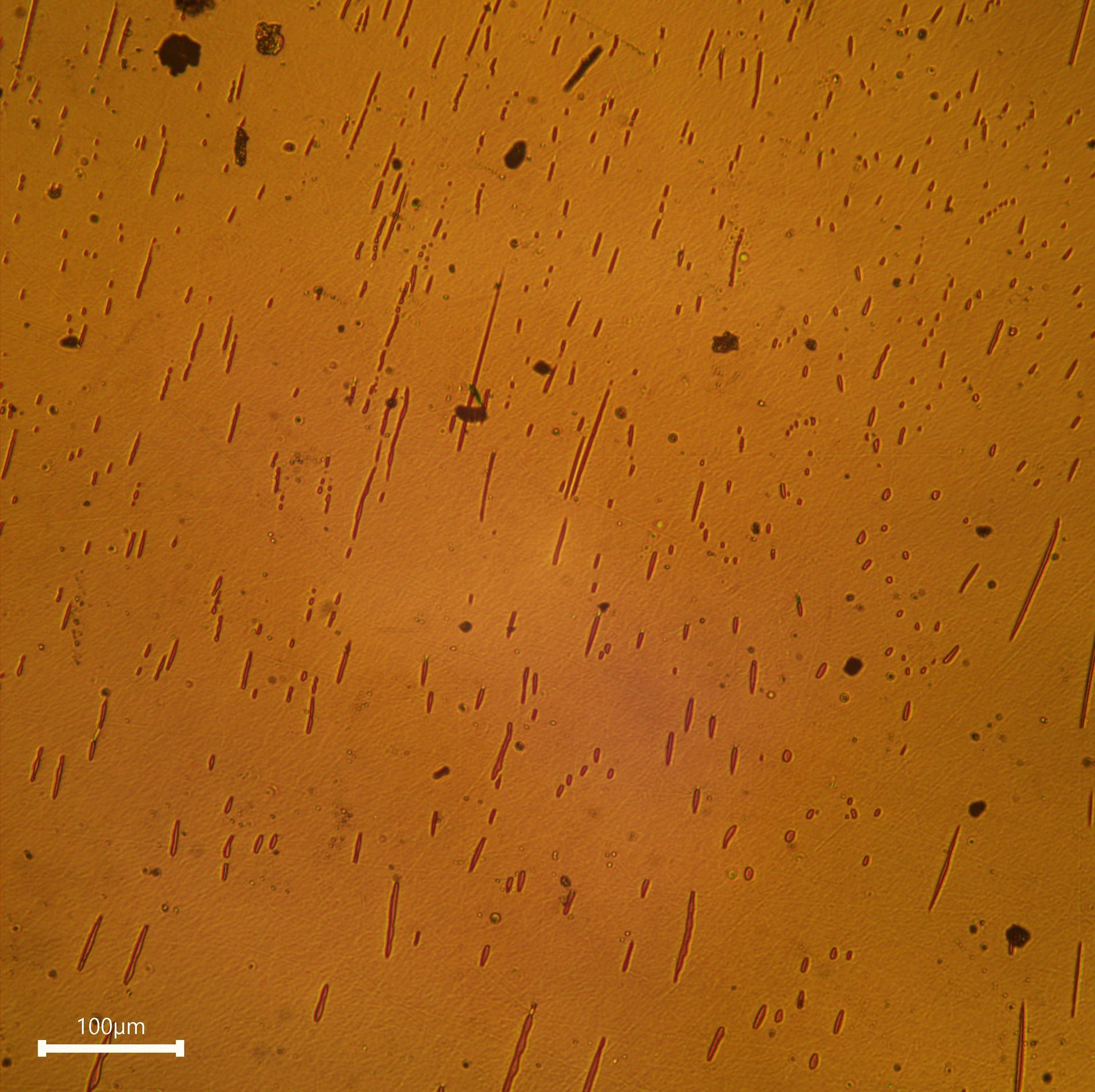
Researchers are continuing to fine-tune in-space production of semiconductor crystals, which are critical for modern devices like cellphones and computers.
The space station’s microgravity environment could enable large-scale manufacturing of complex materials, and leveraging the orbiting platform for crystal production is expected to lead to next-generation semiconductor technologies with higher performance, chip yield, and reliability.
“Semiconductor devices fabricated using crystals from a previous mission demonstrated performance gain by a factor of two and device yield enhanced by a factor of 10 compared to Earth-based counterparts,” said Partha S. Dutta, principal investigator, United Semiconductors LLC in Los Alamitos, California.
Dutta highlighted that three independent parties validated microgravity’s benefits for growing semiconductor crystals and that the commercial value of microgravity-enhanced crystals could be worth more than $1 million per kilogram (2.2 pounds).
Space-manufactured crystals could help meet the need for radiation-hardened, low-power, high-speed electronics and sensors for space systems. They also could provide reduced power use, increased speed, and improved safety. The technology also has ground applications, including electric vehicles, waste heat recovery, and medical tools.
Learn more about the SUBSA-InSPA-SSCug experiment.
Lethal light Germicidal Ultraviolet (UV) light is emitted by an optical fiber running through the center of an agar plateArizona State University
Researchers are examining how microgravity affects ultraviolet (UV) light’s ability to prevent the formation of biofilms — communities of microbes that form in water systems. Investigators developed special optical fibers to deliver the UV light, which could provide targeted, long-lasting, and chemical-free disinfection in space and on Earth.
“In any water-based system, bacterial biofilms can form on surfaces like pipes, valves, and sensors,” said co-investigator Paul Westerhoff, a professor at Arizona State University in Tempe. “This can cause serious problems like corrosion and equipment failure, and affect human health.”
The UV light breaks up DNA in microorganisms, preventing them from reproducing and forming biofilms. Preliminary evidence suggests biofilms behave differently in microgravity, which may affect how the UV light reaches and damages bacterial DNA.
“What we’ll learn about biofilms and UV light in microgravity could help us design safer water and air systems not just for space exploration, but for hospitals, homes, and industries back on Earth,” Westerhoff said.
Learn more about the GULBI experiment.
Sowing seeds for pharmaceuticals NASA astronaut Loral O’Hara displays the specialized sample processor used for pharmaceutical research aboard the International Space StationNASA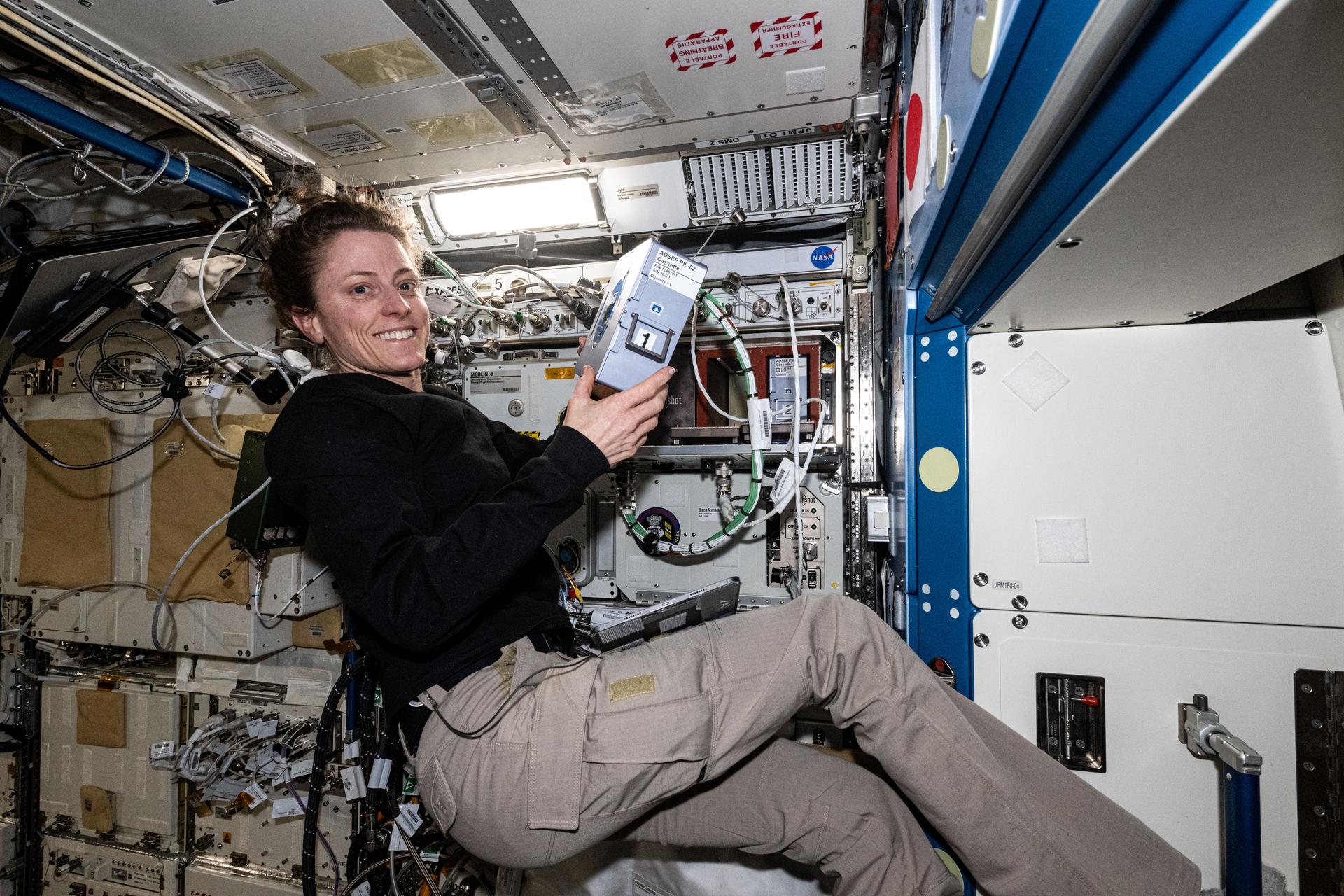
An investigation using a specialized pharmaceutical laboratory aboard the space station examines how microgravity may alter and enhance crystal structures of drug molecules. Crystal structure can affect the production, storage, effectiveness, and administration of medications.
“We are exploring drugs with applications in cardiovascular, immunologic, and neurodegenerative disease as well as cancer,” said principal investigator Ken Savin of Redwire Space Technologies in Greenville, Indiana. “We expect microgravity to yield larger, more uniform crystals.”
Once the samples return to Earth, researchers at Purdue University in West Lafayette, Indiana, will examine the crystal structures.
The investigators hope to use the space-made crystals as seeds to produce significant numbers of crystals on Earth.
“We have demonstrated this technique with a few examples, but need to see if it works in many examples,” Savin said. “It’s like being on a treasure hunt with every experiment.”
This research also helps enhance and expand commercial use of the space station for next-generation biotechnology research and in-space production of medications.
Learn more about the ADSEP PIL-11 experiment.
Keeping fuel cool iss0NASA astronaut Joe Acaba installs hardware for the first effort in 2017 aboard the International Space Station to test controlling pressure in cryogenic fuel tanksNASA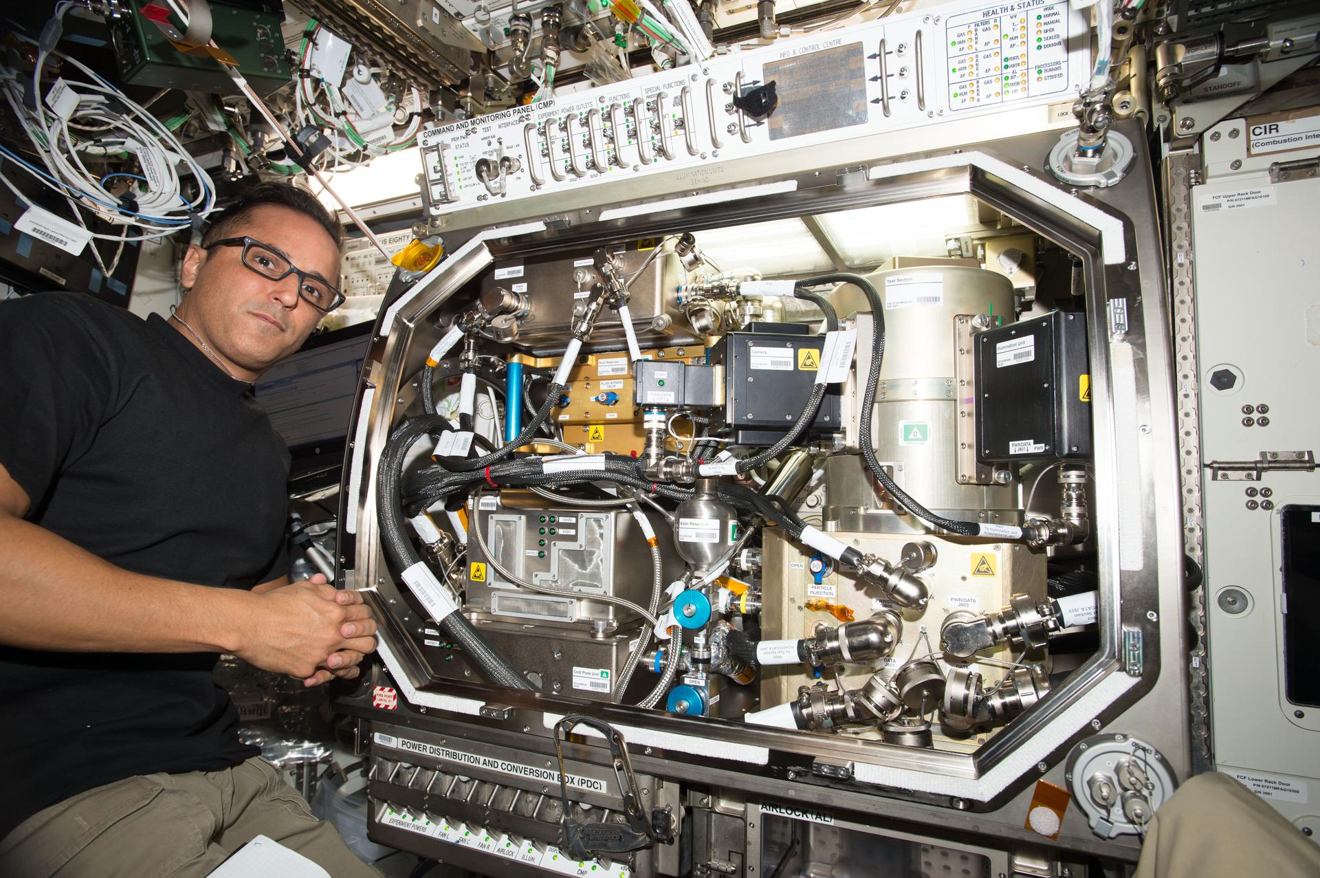
Many spacecraft use cryogenic or extremely cold fluids as fuel for propulsion systems. These fluids are kept at hundreds of degrees below zero to remain in a liquid state, making them difficult to use in space where ambient temperatures can vary significantly. If these fluids get too warm, they turn into gas and boiloff, or slowly evaporate and escape the tank, affecting fuel efficiency and mission planning.
A current practice to prevent this uses onboard fuel to cool systems before transferring fuel, but this practice is wasteful and not feasible for Artemis missions to the Moon and future exploration of Mars and beyond. A potential alternative is using special gases that do not turn into liquids at cold temperatures to act as a barrier in the tank and control the movement of the fuel.
Researchers are testing this method to control fuel tank pressure in microgravity. It could save an estimated 42% of propellant mass per year, according to Mohammad Kassemi, a researcher at NASA’s National Center for Space Exploration Research and Case Western Reserve University in Cleveland.
The test could provide insights that help improve the design of lightweight, efficient, long-term in-space cryogenic storage systems for future deep space exploration missions.
Learn more about the ZBOT-NC experiment.
Download high-resolution photos and videos of the research highlighted in this feature.
Learn more about the research aboard the International Space Station at:
Keep Exploring Discover More Topics From NASALatest News from Space Station Research
Space Station Research and Technology Resources
Space Station Research Results
Humans In Space
NASA, Northrop Grumman to Send Medical, Technology Studies to Space
NASA and Northrop Grumman are preparing to send the company’s next cargo mission to the International Space Station, flying research to support Artemis missions to the Moon and human exploration of Mars and beyond, while improving life on Earth. SpaceX’s Falcon 9 rocket will launch Northrop Grumman’s 23rd commercial resupply services mission to the orbiting laboratory.
The investigations aboard the Cygnus spacecraft aim to refine semiconductor crystals for next-generation technologies, reduce harmful microbes, improve medication production, and manage fuel pressure.
NASA, Northrop Grumman, and SpaceX are targeting launch in mid-September from Space Launch Complex 40 at Cape Canaveral Space Force Station in Florida.
Read about some of the investigations traveling to the space station:
Better semiconductor crystals Optical micrograph of a semiconductor composite wafer with embedded semimetal phases extracted from a space grown crystal in the SUBSA facility during Mission 1United Semiconductors LLCResearchers are continuing to fine-tune in-space production of semiconductor crystals, which are critical for modern devices like cellphones and computers.
The space station’s microgravity environment could enable large-scale manufacturing of complex materials, and leveraging the orbiting platform for crystal production is expected to lead to next-generation semiconductor technologies with higher performance, chip yield, and reliability.
“Semiconductor devices fabricated using crystals from a previous mission demonstrated performance gain by a factor of two and device yield enhanced by a factor of 10 compared to Earth-based counterparts,” said Partha S. Dutta, principal investigator, United Semiconductors LLC in Los Alamitos, California.
Dutta highlighted that three independent parties validated microgravity’s benefits for growing semiconductor crystals and that the commercial value of microgravity-enhanced crystals could be worth more than $1 million per kilogram (2.2 pounds).
Space-manufactured crystals could help meet the need for radiation-hardened, low-power, high-speed electronics and sensors for space systems. They also could provide reduced power use, increased speed, and improved safety. The technology also has ground applications, including electric vehicles, waste heat recovery, and medical tools.
Learn more about the SUBSA-InSPA-SSCug experiment.
Lethal light Germicidal Ultraviolet (UV) light is emitted by an optical fiber running through the center of an agar plateArizona State UniversityResearchers are examining how microgravity affects ultraviolet (UV) light’s ability to prevent the formation of biofilms — communities of microbes that form in water systems. Investigators developed special optical fibers to deliver the UV light, which could provide targeted, long-lasting, and chemical-free disinfection in space and on Earth.
“In any water-based system, bacterial biofilms can form on surfaces like pipes, valves, and sensors,” said co-investigator Paul Westerhoff, a professor at Arizona State University in Tempe. “This can cause serious problems like corrosion and equipment failure, and affect human health.”
The UV light breaks up DNA in microorganisms, preventing them from reproducing and forming biofilms. Preliminary evidence suggests biofilms behave differently in microgravity, which may affect how the UV light reaches and damages bacterial DNA.
“What we’ll learn about biofilms and UV light in microgravity could help us design safer water and air systems not just for space exploration, but for hospitals, homes, and industries back on Earth,” Westerhoff said.
Learn more about the GULBI experiment.
Sowing seeds for pharmaceuticals NASA astronaut Loral O’Hara displays the specialized sample processor used for pharmaceutical research aboard the International Space StationNASAAn investigation using a specialized pharmaceutical laboratory aboard the space station examines how microgravity may alter and enhance crystal structures of drug molecules. Crystal structure can affect the production, storage, effectiveness, and administration of medications.
“We are exploring drugs with applications in cardiovascular, immunologic, and neurodegenerative disease as well as cancer,” said principal investigator Ken Savin of Redwire Space Technologies in Greenville, Indiana. “We expect microgravity to yield larger, more uniform crystals.”
Once the samples return to Earth, researchers at Purdue University in West Lafayette, Indiana, will examine the crystal structures.
The investigators hope to use the space-made crystals as seeds to produce significant numbers of crystals on Earth.
“We have demonstrated this technique with a few examples, but need to see if it works in many examples,” Savin said. “It’s like being on a treasure hunt with every experiment.”
This research also helps enhance and expand commercial use of the space station for next-generation biotechnology research and in-space production of medications.
Learn more about the ADSEP PIL-11 experiment.
Keeping fuel cool iss0NASA astronaut Joe Acaba installs hardware for the first effort in 2017 aboard the International Space Station to test controlling pressure in cryogenic fuel tanksNASAMany spacecraft use cryogenic or extremely cold fluids as fuel for propulsion systems. These fluids are kept at hundreds of degrees below zero to remain in a liquid state, making them difficult to use in space where ambient temperatures can vary significantly. If these fluids get too warm, they turn into gas and boiloff, or slowly evaporate and escape the tank, affecting fuel efficiency and mission planning.
A current practice to prevent this uses onboard fuel to cool systems before transferring fuel, but this practice is wasteful and not feasible for Artemis missions to the Moon and future exploration of Mars and beyond. A potential alternative is using special gases that do not turn into liquids at cold temperatures to act as a barrier in the tank and control the movement of the fuel.
Researchers are testing this method to control fuel tank pressure in microgravity. It could save an estimated 42% of propellant mass per year, according to Mohammad Kassemi, a researcher at NASA’s National Center for Space Exploration Research and Case Western Reserve University in Cleveland.
The test could provide insights that help improve the design of lightweight, efficient, long-term in-space cryogenic storage systems for future deep space exploration missions.
Learn more about the ZBOT-NC experiment.
Download high-resolution photos and videos of the research highlighted in this feature.
Learn more about the research aboard the International Space Station at:
Keep Exploring Discover More Topics From NASALatest News from Space Station Research
Space Station Research and Technology Resources
Space Station Research Results
Humans In Space
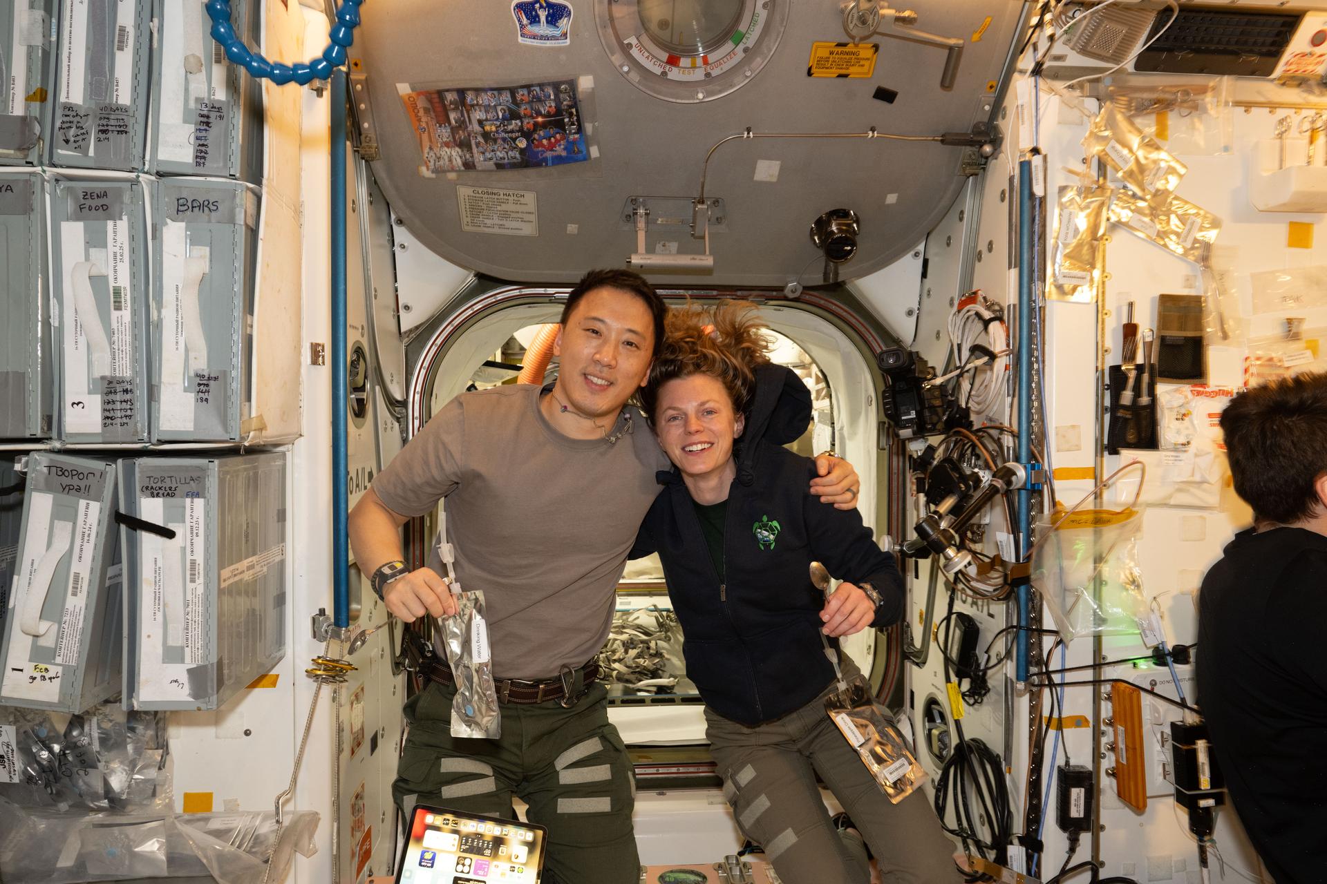
NASA astronauts Jonny Kim and Zena Cardman pose for a portrait in the Unity module
NASA astronauts Jonny Kim and Zena Cardman pose for a portrait in the Unity module
NASA astronauts Jonny Kim and Zena Cardman, both Expedition 73 Flight Engineers, pose for a portrait inside the International Space Station‘s Unity module during a break in weekend housecleaning and maintenance activities. Kim and Cardman are both part of NASA Astronaut Group 22 selected in June 2017 with 12 other astronauts, including two Canadian Space Agency astronauts, and affectionately nicknamed “The Turtles.”
In its third decade of continuous human presence, the space station has a far-reaching impact as a microgravity lab hosting technology, demonstrations, and scientific investigations from a range of fields. The research done by astronauts on the orbiting laboratory will inform long-duration missions like Artemis and future human expeditions to Mars.
Learn more about station activities by following the space station blog.
See The Coolest Moon Features Tonight!
NASA Contract Officer Helps Power Journey Back to the Moon
When NASA’s Artemis II mission launches in 2026, it will inspire the world through discovery in a new Golden Age of innovation and exploration.
It will be another inspiring NASA moment Patricia White can add to her growing list.
White supports the Artemis program to send astronauts to the Moon to prepare for future human exploration of Mars as a contracting officer at NASA’s Stennis Space Center near Bay St. Louis, Mississippi.
White takes special pride in the test operations contract she helped draft. The contract provides support to the Fred Haise Test Stand, which tests the RS-25 engines that will help power NASA’s SLS (Space Launch System) rocket on Artemis missions.
“I was awestruck the first time I witnessed an engine test,” White said. “I remember how small I felt in comparison to this big and fascinating world, and I wondered what that engine would see that I would never be able to see.”
Four RS-25 engines tested at NASA Stennis will help launch Artemis II with four astronauts to venture around the Moon. As the first crewed Artemis mission, it will represent another milestone for the nation’s human space exploration effort.
From Interstate Signs to NASA CareerWhite describes NASA Stennis as a hidden gem. Growing up in nearby Slidell, Louisiana, she had driven by the interstate signs pointing toward NASA Stennis her entire life.
When she heard about a job opportunity at the center, she immediately applied. Initially hired as a contractor with only a high school diploma in February 2008, White found her motivation among NASA’s ranks.
“I work with very inspiring people, and it only took one person to say, ‘You should go to college’ to give me the courage to go so late in life,” she said.
Hard But Worth ItWhite began college classes in her 40s and finished at 50. She balanced a marriage, full-time job, academic studies, and household responsibilities. When she started her educational journey, her children were either toddlers or newborns. They were growing up as she stayed in school for nine years while meeting life’s challenges.
“It was hard, but it was so worth it,” she said. “I love my job and what I do, and even though it is crazy busy, I look forward to working at NASA every single day.”
She joined NASA officially in 2013, going from contractor to civil servant.
Setting an ExampleWhite’s proudest work moment came when she brought home the NASA Early Career Achievement award and medal. It served as a tangible symbol of her success she could share with her family.
“It was a long road from being hired as an intern, and we all made extraordinary sacrifices,” she said. “I wanted to share it with them and set a good example for my children.”
As Artemis II prepares to carry humans back to lunar orbit for the first time in over 50 years, White takes pride knowing her work helps power humanity’s return to deep space exploration. Her work is proof that sometimes the most important journeys begin right in one’s own backyard.
Learn More About Careers at NASA Stennis Explore More 4 min read NASA Stennis Provides Ideal Setting for Range Operations Article 1 week ago 10 min read NASA’s Stennis Space Center Employees Receive NASA Honor Awards Article 3 weeks ago 6 min read A Defining Era: NASA Stennis and Space Shuttle Main Engine Testing Article 4 months agoGlittering Glimpse of Star Birth From NASA’s Webb Telescope
- Webb
- News
- Overview
- Science
- Observatory
- Multimedia
- Team
- More
Image: NASA, ESA, CSA, STScI; Image Processing: A. Pagan (STScI)
This is a sparkling scene of star birth captured by NASA’s James Webb Space Telescope. What appears to be a craggy, starlit mountaintop kissed by wispy clouds is actually a cosmic dust-scape being eaten away by the blistering winds and radiation of nearby, massive, infant stars.
Called Pismis 24, this young star cluster resides in the core of the nearby Lobster Nebula, approximately 5,500 light-years from Earth in the constellation Scorpius. Home to a vibrant stellar nursery and one of the closest sites of massive star birth, Pismis 24 provides rare insight into large and massive stars. Its proximity makes this region one of the best places to explore the properties of hot young stars and how they evolve.
At the heart of this glittering cluster is the brilliant Pismis 24-1. It is at the center of a clump of stars above the jagged orange peaks, and the tallest spire is pointing directly toward it. Pismis 24-1 appears as a gigantic single star, and it was once thought to be the most massive known star. Scientists have since learned that it is composed of at least two stars, though they cannot be resolved in this image. At 74 and 66 solar masses, respectively, the two known stars are still among the most massive and luminous stars ever seen.
Image A: Pismis 24 (NIRCam Image) Webb captured this sparkling scene of star birth in Pismis 24, a young star cluster about 5,500 light-years from Earth in the constellation Scorpius. This region is one of the best places to explore the properties of hot young stars and how they evolve. Image: NASA, ESA, CSA, STScI; Image Processing: A. Pagan (STScI)Captured in infrared light by Webb’s NIRCam (Near-Infrared Camera), this image reveals thousands of jewel-like stars of varying sizes and colors. The largest and most brilliant ones with the six-point diffraction spikes are the most massive stars in the cluster. Hundreds to thousands of smaller members of the cluster appear as white, yellow, and red, depending on their stellar type and the amount of dust enshrouding them. Webb also shows us tens of thousands of stars behind the cluster that are part of the Milky Way galaxy.
Super-hot, infant stars –some almost 8 times the temperature of the Sun – blast out scorching radiation and punishing winds that are sculpting a cavity into the wall of the star-forming nebula. That nebula extends far beyond NIRCam’s field of view. Only small portions of it are visible at the bottom and top right of the image. Streamers of hot, ionized gas flow off the ridges of the nebula, and wispy veils of gas and dust, illuminated by starlight, float around its towering peaks.
Dramatic spires jut from the glowing wall of gas, resisting the relentless radiation and winds. They are like fingers pointing toward the hot, young stars that have sculpted them. The fierce forces shaping and compressing these spires cause new stars to form within them. The tallest spire spans about 5.4 light-years from its tip to the bottom of the image. More than 200 of our solar systems out to Neptune’s orbit could fit into the width its tip, which is 0.14 lightyears.
In this image, the color cyan indicates hot or ionized hydrogen gas being heated up by the massive young stars. Dust molecules similar to smoke here on Earth are represented in orange. Red signifies cooler, denser molecular hydrogen. The darker the red, the denser the gas. Black denotes the densest gas, which is not emitting light. The wispy white features are dust and gas that are scattering starlight.
Video A: Expedition to Star Cluster Pismis 24To view this video please enable JavaScript, and consider upgrading to a web browser that
supports HTML5 video
Video: NASA, ESA, CSA, STScI, Alyssa Pagan (STScI); Narration: Frank Summers (STScI); Script Writer: Frank Summers (STScI); Music: Christian Nieves (STScI); Audio: Danielle Kirshenblat (STScI); Producer: Greg Bacon (STScI); Acknowledgment: VISTA, Akira Fujii, DSS
The James Webb Space Telescope is the world’s premier space science observatory. Webb is solving mysteries in our solar system, looking beyond to distant worlds around other stars, and probing the mysterious structures and origins of our universe and our place in it. Webb is an international program led by NASA with its partners, ESA (European Space Agency) and CSA (Canadian Space Agency).
To learn more about Webb, visit:
DownloadsClick any image to open a larger version.
View/Download all image products at all resolutions for this article from the Space Telescope Science Institute.
Media ContactsLaura Betz – laura.e.betz@nasa.gov
NASA’s Goddard Space Flight Center, Greenbelt, Md.
Ann Jenkins – jenkins@stsci.edu
Space Telescope Science Institute, Baltimore, Md.
Read more about Hubble’s view of Pismis 24
Listen to a sonification of Hubble’s view of Pismis 24
Animation Video: “How Dense Pillars Form in Molecular Clouds”
Read more: Webb’s Star Formation Discoveries
Related For Kids En Español Keep Exploring Related Topics James Webb Space TelescopeWebb is the premier observatory of the next decade, serving thousands of astronomers worldwide. It studies every phase in the…
Stars
Stars Stories
Universe
Share Details Last Updated Sep 04, 2025 Related Terms
Glittering glimpse of star birth
Early penguins may have used dagger-like beaks to skewer prey
Early penguins may have used dagger-like beaks to skewer prey
Galileo ‘daughter mission’ name revealed: Celeste
Following the announcement of the upcoming launch of LEO-PNT’s first satellites, ESA has now unveiled the name of the mission. Celeste, as it has been officially designated, will test the potential of a new, low Earth orbit layer of satellites to enhance Galileo’s resilience and complement its capabilities.
NASA Glenn Tests Mini-X-Ray Technology to Advance Space Health Care
4 min read
Preparations for Next Moonwalk Simulations Underway (and Underwater) Researchers Kelly Gilkey, Cy Peverill, Daniel Phan, Chase Haddix, and Ariel Tokarz test portable, handheld X-ray systems for use during future long-duration space missions at NASA’s Glenn Research Center in Cleveland on Friday, March 21, 2025. Credit: NASA/Sara Lowthian-Hanna
As NASA plans future human exploration missions to the Moon, Mars, and beyond, new and unique challenges emerge — like communication delays and limited return-to-Earth options — so enhanced medical care capabilities are critical. Crews will need non-invasive imaging technology to diagnose medical conditions, like broken bones or dental injuries.
Scientists at NASA’s Glenn Research Center in Cleveland are testing portable, handheld X-ray systems for use during future extended space missions. Having portable X-ray capabilities aboard spacecraft would allow astronauts to immediately assess and treat potential injuries or identify equipment issues without having to disassemble the gear.
“Technological innovations like that of the mini-X-ray will help keep our astronauts healthy as we endeavor farther into space than ever before,” said acting NASA Administrator Sean Duffy. “Future missions to the Moon and Mars will be safer due to the research of our scientists at NASA Glenn.”
NASA reviewed more than 200 commercial systems — analyzing size, weight, image quality, ease-of-use, cost, and safety — and selected three systems for further testing: MinXray, Remedi, and Fujifilm.
“We’re working to provide evidence on why a mini-X-ray system should be included in future space exploration,” said Dr. Chase Haddix, a senior biomedical engineering research contractor working for Universities Space Research Association at NASA Glenn. “These X-rays could be used to detect both clinical and non-clinical diagnostics, meaning they can check an astronaut’s body or identify the location of a tear in an astronaut suit.”
Researchers capture X-ray images of a shape memory alloy rover tire at NASA’s Glenn Research Center in Cleveland on Friday, March 21, 2025. Credit: NASA/Sara Lowthian-Hanna
NASA Glenn is collaborating with other centers, including NASA’s Johnson Space Center in Houston and NASA’s Langley Research Center in Hampton, Virginia, and radiography experts at University Hospitals and Cuyahoga Community College in Cleveland.
“We’re fortunate to have enthusiastic medical and radiography experts right here in our community,” said Dr. Cy Peverill, project task lead at NASA Glenn. “Their knowledge and experience are invaluable as we work to test medical technologies that could significantly improve management of astronaut health on future missions to the Moon or Mars.”
Cuyahoga Community College contributed anatomical phantoms, which are lifelike models of the human body, in its radiography laboratory on the Western Campus and dental hygiene clinical facility at the Metropolitan Campus. Faculty and students consulted with NASA researchers on essential imaging principles, including patient positioning, image acquisition, and image quality.
University Hospitals is partnering with NASA Glenn on a medical study with real patients to compare the performance of the X-ray systems against hospital-grade equipment, focusing on usability, image clarity, and diagnostic accuracy.
“Astronauts live and work in small quarters, much smaller spaces than in a hospital,” Haddix said. “The system must be easy to use since astronauts may not be experienced in radiography. The data from these tests will guide the selection of the most suitable system for future missions.”
Researchers capture X-ray images of an astronaut spacesuit at NASA’s Glenn Research Center in Cleveland on Friday, March 21, 2025. Credit: NASA/Sara Lowthian-Hanna
Using portable X-rays to improve health care in inaccessible areas is not new, with systems deployed to diagnose medical issues in places such as base camps in Nepal and remote villages in South Africa. NASA researchers theorize that if these systems are successful in high elevations and extreme temperatures on Earth, perhaps they are durable enough for space missions.
Glenn researchers will continue to collect data from all collaborators, including from an X-ray system sourced by SpaceX that launched in April during the Fram2 mission. The crew captured the first human X-ray images in space during their four-day mission to low Earth orbit. NASA plans to select a device near the end of 2025 and will test the chosen system aboard the International Space Station in 2026 or early 2027.
The Mars Campaign Office at NASA Headquarters in Washington and the agency’s Human Research Program at NASA Johnson fund this work as both organizations focus on pursuing technologies and methods to support safe, productive human space travel.
Explore More 5 min read Glittering Glimpse of Star Birth From NASA’s Webb TelescopeThis is a sparkling scene of star birth captured by NASA’s James Webb Space Telescope.…
Article 15 hours ago 2 min read Lydia Rodriguez Builds a Career of Service and Support at NASA Article 2 days ago 3 min read What’s Up: September 2025 Skywatching Tips from NASASaturn’s spectacle, a Conjunction, and the Autumnal Equinox Saturn shines throughout the month, a conjunction…
Article 3 days agoNASA Glenn Tests Mini-X-Ray Technology to Advance Space Health Care
4 min read
Preparations for Next Moonwalk Simulations Underway (and Underwater) Researchers Kelly Gilkey, Cy Peverill, Daniel Phan, Chase Haddix, and Ariel Tokarz test portable, handheld X-ray systems for use during future long-duration space missions at NASA’s Glenn Research Center in Cleveland on Friday, March 21, 2025. Credit: NASA/Sara Lowthian-HannaAs NASA plans future human exploration missions to the Moon, Mars, and beyond, new and unique challenges emerge — like communication delays and limited return-to-Earth options — so enhanced medical care capabilities are critical. Crews will need non-invasive imaging technology to diagnose medical conditions, like broken bones or dental injuries.
Scientists at NASA’s Glenn Research Center in Cleveland are testing portable, handheld X-ray systems for use during future extended space missions. Having portable X-ray capabilities aboard spacecraft would allow astronauts to immediately assess and treat potential injuries or identify equipment issues without having to disassemble the gear.
“Technological innovations like that of the mini-X-ray will help keep our astronauts healthy as we endeavor farther into space than ever before,” said acting NASA Administrator Sean Duffy. “Future missions to the Moon and Mars will be safer due to the research of our scientists at NASA Glenn.”
NASA reviewed more than 200 commercial systems — analyzing size, weight, image quality, ease-of-use, cost, and safety — and selected three systems for further testing: MinXray, Remedi, and Fujifilm.
“We’re working to provide evidence on why a mini-X-ray system should be included in future space exploration,” said Dr. Chase Haddix, a senior biomedical engineering research contractor working for Universities Space Research Association at NASA Glenn. “These X-rays could be used to detect both clinical and non-clinical diagnostics, meaning they can check an astronaut’s body or identify the location of a tear in an astronaut suit.”
Researchers capture X-ray images of a shape memory alloy rover tire at NASA’s Glenn Research Center in Cleveland on Friday, March 21, 2025. Credit: NASA/Sara Lowthian-HannaNASA Glenn is collaborating with other centers, including NASA’s Johnson Space Center in Houston and NASA’s Langley Research Center in Hampton, Virginia, and radiography experts at University Hospitals and Cuyahoga Community College in Cleveland.
“We’re fortunate to have enthusiastic medical and radiography experts right here in our community,” said Dr. Cy Peverill, project task lead at NASA Glenn. “Their knowledge and experience are invaluable as we work to test medical technologies that could significantly improve management of astronaut health on future missions to the Moon or Mars.”
Cuyahoga Community College contributed anatomical phantoms, which are lifelike models of the human body, in its radiography laboratory on the Western Campus and dental hygiene clinical facility at the Metropolitan Campus. Faculty and students consulted with NASA researchers on essential imaging principles, including patient positioning, image acquisition, and image quality.
University Hospitals is partnering with NASA Glenn on a medical study with real patients to compare the performance of the X-ray systems against hospital-grade equipment, focusing on usability, image clarity, and diagnostic accuracy.
“Astronauts live and work in small quarters, much smaller spaces than in a hospital,” Haddix said. “The system must be easy to use since astronauts may not be experienced in radiography. The data from these tests will guide the selection of the most suitable system for future missions.”
Researchers capture X-ray images of an astronaut spacesuit at NASA’s Glenn Research Center in Cleveland on Friday, March 21, 2025. Credit: NASA/Sara Lowthian-HannaUsing portable X-rays to improve health care in inaccessible areas is not new, with systems deployed to diagnose medical issues in places such as base camps in Nepal and remote villages in South Africa. NASA researchers theorize that if these systems are successful in high elevations and extreme temperatures on Earth, perhaps they are durable enough for space missions.
Glenn researchers will continue to collect data from all collaborators, including from an X-ray system sourced by SpaceX that launched in April during the Fram2 mission. The crew captured the first human X-ray images in space during their four-day mission to low Earth orbit. NASA plans to select a device near the end of 2025 and will test the chosen system aboard the International Space Station in 2026 or early 2027.
The Mars Campaign Office at NASA Headquarters in Washington and the agency’s Human Research Program at NASA Johnson fund this work as both organizations focus on pursuing technologies and methods to support safe, productive human space travel.
Explore More 5 min read Glittering Glimpse of Star Birth From NASA’s Webb TelescopeThis is a sparkling scene of star birth captured by NASA’s James Webb Space Telescope.…
Article 10 hours ago 2 min read Lydia Rodriguez Builds a Career of Service and Support at NASA Article 2 days ago 3 min read What’s Up: September 2025 Skywatching Tips from NASASaturn’s spectacle, a Conjunction, and the Autumnal Equinox Saturn shines throughout the month, a conjunction…
Article 2 days agoThe ESA Restores Communications with JUICE at Venus
The European Space Agency’s Jupiter Icy Moons Explorer (Juice) suffered a communications anomaly on its way Venus for a gravity-assist maneuver. Thanks to swift and coordinated action by the teams at ESA’s European Space Operations Centre (ESOC) and Airbus, communications were restored in time to prepare for its upcoming flyby with Venus.