
Feed aggregator
‘Touchy-feely’ dark matter is having a moment
Models giving dark matter more complex behavior could help solve multiple cosmic mysteries
Read the winner of this year’s Young Science Writer Award
Read the winner of this year’s Young Science Writer Award
What are AI agents? Inside a real experiment where AI ran a start‑up
Journalist Evan Ratliff explores what happens when AI agents are given real autonomy to build and run a start‑up from scratch
Webb & Hubble find massive star clusters emerge faster
Astronomers using the NASA/ESA/CSA James Webb Space Telescope together with the NASA/ESA Hubble Space Telescope have looked deeply at thousands of young star clusters in four nearby galaxies, studying clusters at different stages of evolution. Their findings show that more massive star clusters emerge more quickly from the clouds they are born in, clearing away gas and filling the galaxy with ultraviolet light. The result gives us a better understanding of star formation in galaxies, as well as how and where planets can form.
ESA and DON’T NOD team up on a journey to the planet Persephone in Aphelion
The European Space Agency (ESA) has partnered with French video game studio DON’T NOD Entertainment on the development of Aphelion, a narrative science‑fiction game inspired by space exploration and scientific expertise.
Melting Snow Off Shivelyuch
- Earth
- Earth Observatory
- Image of the Day
- EO Explorer
- Topics
- More Content
- About
Melting Snow Off Shivelyuch
- Earth
- Earth Observatory
- Image of the Day
- EO Explorer
- Topics
- More Content
- About
Extinct relative of koalas discovered in Western Australia
Extinct relative of koalas discovered in Western Australia
NASA eClips and GLOBE Educators Strengthen a Regional STEM Ecosystem in Coastal Virginia
3 min read
NASA eClips and GLOBE Educators Strengthen a Regional STEM Ecosystem in Coastal Virginia Jessica Taylor, Physical Scientist at NASA Langley Research Center and Principle Investigator for GLOBE Clouds and the My NASA Data project, explains calibration of an infrared thermometer.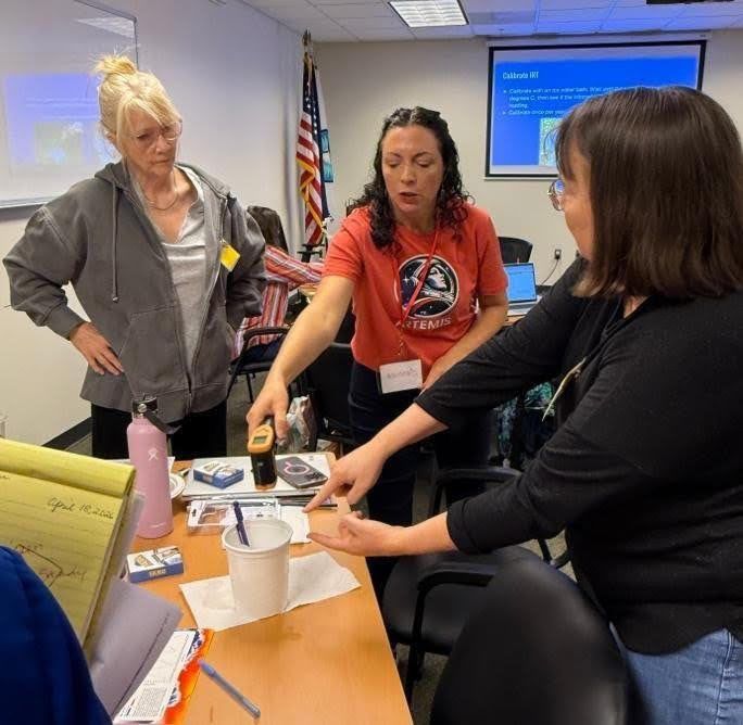
Thirty-eight science educators representing seven school districts across Virginia’s Tidewater region joined forces with community organizations, such as the Elizabeth River Project, to deepen their instructional practice through a dynamic collaboration between NASA eClips and the GLOBE (Global Learning and Observation to Benefit the Environment) Program. Together, these groups are cultivating a regional STEM ecosystem that connects classrooms, community science, and NASA resources in meaningful and lasting ways.
As part of NASA’s Science Activation Program, NASA eClips engages educators and learners with standards-aligned resources grounded in authentic NASA science. Complementing this work, the GLOBE Program empowers participants to contribute to citizen science through environmental data collection and analysis. The partnership between these two programs creates a powerful bridge between content knowledge and real-world application – bringing Earth Systems science to life for both educators and learners.
Educators gathered for a three-hour professional learning experience on March 7 or April 18, 2026 at the National Institute of Aerospace in Hampton, Virginia. Through hands-on investigations, participants explored how land cover influences surface temperature, how clouds impact atmospheric conditions, and how soil plays a critical role in environmental systems. These experiences were anchored in NASA eClips resources and GLOBE protocols, offering practical strategies for teaching key Virginia Science Standards of Learning related to weather, climate, land covering, and Earth’s energy budget.
Participants calibrated and used scientific instruments such as infrared thermometers and multi-day minimum/maximum thermometers, gaining confidence in collecting accurate environmental data. They examined the urban heat island effect, engaged in interactive activities including an energetic cloud dance and a cloud opacity demonstration, and learned how to contribute observations through practice of using the GLOBE Observer app. These immersive experiences not only strengthened content knowledge but also modeled how authentic science practices can be integrated into classroom instruction.
This initiative builds on two years of intentional collaboration among the NASA eClips Educators from the National Institute of Aerospace’s Center for Integrative STEM Education (NIA-CISE); GLOBE scientists from NASA Langley Research Center; and regional school divisions and community organizations that laid the foundation for a sustainable regional STEM ecosystem. Support from the Coastal Virginia STEM Hub, funded through the Virginia General Assembly, has been instrumental in expanding access to these opportunities. Grant funding provided educator stipends and enabled the purchase of essential equipment, including weather instrument shelters and soil kits. In a powerful example of cross-sector collaboration, the instrument shelters were constructed by Career and Technical Education (CTE) students in Hampton City Schools and Norfolk Public Schools using GLOBE specifications, further connecting students to the scientific process while supporting their peers’ learning.
As participating school divisions and community organizations integrate NASA eClips and GLOBE resources into their curricula and outreach efforts, they are ensuring that all learners have access to authentic, data-driven science experiences. Together, this network of educators, students, and partners is not only enhancing science education, but also building a connected, collaborative STEM ecosystem where learning extends beyond the classroom and into the community.
NASA eClips, led by NIA-CISE, is supported by NASA under cooperative agreement award number NNX16AB91A and is part of NASA’s Science Activation Portfolio. Learn more about how Science Activation connects NASA science experts, real content, and experiences with community leaders to do science in ways that activate minds and promote deeper understanding of our world and beyond: https://science.nasa.gov/learn/about-science-activation/
Share Details Last Updated May 05, 2026 Editor NASA Science Editorial Team Related Terms Explore More 3 min read New NASA HEAT Coloring Book Blends Art, Science, and Cultural PerspectivesA new Sun-centered and science-focused coloring book produced by NASA in partnership with the University…
Article
7 hours ago
4 min read Breaking Barriers at 3rd Annual Findings from the Field Symposium
This year’s Findings from the Field Student Research Symposium welcomed 106 students, grades four through…
Article
1 day ago
4 min read Artemis Moon Tree Dedicated in Honor of Mary W. Jackson
Article
1 month ago
Keep Exploring Discover More Topics From NASA James Webb Space Telescope
Webb is the premier observatory of the next decade, serving thousands of astronomers worldwide. It studies every phase in the…
Perseverance Rover
This rover and its aerial sidekick were assigned to study the geology of Mars and seek signs of ancient microbial…
Parker Solar Probe
On a mission to “touch the Sun,” NASA’s Parker Solar Probe became the first spacecraft to fly through the corona…
Juno
NASA’s Juno spacecraft entered orbit around Jupiter in 2016, the first explorer to peer below the planet’s dense clouds to…
NASA eClips and GLOBE Educators Strengthen a Regional STEM Ecosystem in Coastal Virginia
3 min read
NASA eClips and GLOBE Educators Strengthen a Regional STEM Ecosystem in Coastal Virginia Jessica Taylor, Physical Scientist at NASA Langley Research Center and Principle Investigator for GLOBE Clouds and the My NASA Data project, explains calibration of an infrared thermometer.Thirty-eight science educators representing seven school districts across Virginia’s Tidewater region joined forces with community organizations, such as the Elizabeth River Project, to deepen their instructional practice through a dynamic collaboration between NASA eClips and the GLOBE (Global Learning and Observation to Benefit the Environment) Program. Together, these groups are cultivating a regional STEM ecosystem that connects classrooms, community science, and NASA resources in meaningful and lasting ways.
As part of NASA’s Science Activation Program, NASA eClips engages educators and learners with standards-aligned resources grounded in authentic NASA science. Complementing this work, the GLOBE Program empowers participants to contribute to citizen science through environmental data collection and analysis. The partnership between these two programs creates a powerful bridge between content knowledge and real-world application – bringing Earth Systems science to life for both educators and learners.
Educators gathered for a three-hour professional learning experience on March 7 or April 18, 2026 at the National Institute of Aerospace in Hampton, Virginia. Through hands-on investigations, participants explored how land cover influences surface temperature, how clouds impact atmospheric conditions, and how soil plays a critical role in environmental systems. These experiences were anchored in NASA eClips resources and GLOBE protocols, offering practical strategies for teaching key Virginia Science Standards of Learning related to weather, climate, land covering, and Earth’s energy budget.
Participants calibrated and used scientific instruments such as infrared thermometers and multi-day minimum/maximum thermometers, gaining confidence in collecting accurate environmental data. They examined the urban heat island effect, engaged in interactive activities including an energetic cloud dance and a cloud opacity demonstration, and learned how to contribute observations through practice of using the GLOBE Observer app. These immersive experiences not only strengthened content knowledge but also modeled how authentic science practices can be integrated into classroom instruction.
This initiative builds on two years of intentional collaboration among the NASA eClips Educators from the National Institute of Aerospace’s Center for Integrative STEM Education (NIA-CISE); GLOBE scientists from NASA Langley Research Center; and regional school divisions and community organizations that laid the foundation for a sustainable regional STEM ecosystem. Support from the Coastal Virginia STEM Hub, funded through the Virginia General Assembly, has been instrumental in expanding access to these opportunities. Grant funding provided educator stipends and enabled the purchase of essential equipment, including weather instrument shelters and soil kits. In a powerful example of cross-sector collaboration, the instrument shelters were constructed by Career and Technical Education (CTE) students in Hampton City Schools and Norfolk Public Schools using GLOBE specifications, further connecting students to the scientific process while supporting their peers’ learning.
As participating school divisions and community organizations integrate NASA eClips and GLOBE resources into their curricula and outreach efforts, they are ensuring that all learners have access to authentic, data-driven science experiences. Together, this network of educators, students, and partners is not only enhancing science education, but also building a connected, collaborative STEM ecosystem where learning extends beyond the classroom and into the community.
NASA eClips, led by NIA-CISE, is supported by NASA under cooperative agreement award number NNX16AB91A and is part of NASA’s Science Activation Portfolio. Learn more about how Science Activation connects NASA science experts, real content, and experiences with community leaders to do science in ways that activate minds and promote deeper understanding of our world and beyond: https://science.nasa.gov/learn/about-science-activation/
Share Details Last Updated May 05, 2026 Editor NASA Science Editorial Team Related Terms Explore More 3 min read New NASA HEAT Coloring Book Blends Art, Science, and Cultural PerspectivesA new Sun-centered and science-focused coloring book produced by NASA in partnership with the University…
Article
7 hours ago
4 min read Breaking Barriers at 3rd Annual Findings from the Field Symposium
This year’s Findings from the Field Student Research Symposium welcomed 106 students, grades four through…
Article
1 day ago
4 min read Artemis Moon Tree Dedicated in Honor of Mary W. Jackson
Article
1 month ago
Keep Exploring Discover More Topics From NASA James Webb Space Telescope
Webb is the premier observatory of the next decade, serving thousands of astronomers worldwide. It studies every phase in the…
Perseverance Rover
This rover and its aerial sidekick were assigned to study the geology of Mars and seek signs of ancient microbial…
Parker Solar Probe
On a mission to “touch the Sun,” NASA’s Parker Solar Probe became the first spacecraft to fly through the corona…
Juno
NASA’s Juno spacecraft entered orbit around Jupiter in 2016, the first explorer to peer below the planet’s dense clouds to…
Carbon dioxide levels in the atmosphere just hit a ‘depressing’ record high
These data come from the National Oceanic and Atmospheric Administration’s Mauna Loa Observatory, which may soon be shut down because of proposed government budget cuts
NASA’s Perseverance Mars Rover Surveys ‘Crocodile Bridge’
NASA/JPL-Caltech/ASU/MSSS Description
NASA’s Perseverance Mars rover used its Mastcam-Z camera system to capture this 360-degree panorama of a region nicknamed “Crocodile Bridge” on Jezero Crater’s rim. The panorama is made up of 980 images, 971 of which were taken on Dec. 18, 2025, the 1,717th Martian day, or sol, of the mission. An additional nine were taken on Jan. 25, 2026, Sol 1,754. This natural-color view has been processed to show the landscape as the human eye would see it.
Jezero Crater’s rim and the regions around it hold some of the oldest rocks anywhere in the solar system; they serve as time capsules of the Red Planet’s early history, when its crust and atmosphere were still forming. No terrain this ancient exists on Earth, where tectonic plates constantly recycle the surface. (Mars lacks tectonic plates, allowing some of this very old material to be preserved.)
“Crocodile Bridge” represents a transition into an area nicknamed “Lac de Charmes,” which Perseverance will explore for several months later this year.
[Full-resolution image versions of figures A through E can be downloaded at the bottom of this page.]
Figure A (low resolution)
Figure A is the natural-color view panorama.
Figure B (low resolution)
Figure B is the same panorama in an enhanced-color view, which brings out subtle details.
Figure C (low resolution)
Figure C is an anaglyph (3D) version of the natural-color view of the panorama.
Figure D (low resolution)
Figure D is an anaglyph red-color view of the enhanced version of the panorama.
Figure E (low resolution)
Figure E is an anaglyph blue-color view of the enhanced version of the panorama.
Managed for NASA by Caltech, NASA’s Jet Propulsion Laboratory in Southern California built and manages operations of the Perseverance rover on behalf of the agency’s Science Mission Directorate as part of NASA’s Mars Exploration Program portfolio.
Arizona State University leads the operations of the Mastcam-Z instrument, working in collaboration with Malin Space Science Systems in San Diego, on the design, fabrication, testing, and operation of the cameras, and in collaboration with the Niels Bohr Institute of the University of Copenhagen on the design, fabrication, and testing of the calibration targets.
To learn more about Perseverance, visit:
science.nasa.gov/mission/mars-2020-perseverance
Downloads PIA26699 Figure A
TIFF (4.13 GB)
PIA26699 Figure B
TIFF (4.16 GB)
PIA26699 Figure C
TIFF (4.42 GB)
PIA26699 Figure D
TIFF (3.66 GB)
PIA26699 Figure E
TIFF (3.53 GB)
Keep Exploring Discover More Topics From Photojournal
Photojournal
Search Photojournal
Photojournal’s Latest Content
Feedback
NASA’s Perseverance Mars Rover Surveys ‘Crocodile Bridge’
NASA/JPL-Caltech/ASU/MSSS Description
NASA’s Perseverance Mars rover used its Mastcam-Z camera system to capture this 360-degree panorama of a region nicknamed “Crocodile Bridge” on Jezero Crater’s rim. The panorama is made up of 980 images, 971 of which were taken on Dec. 18, 2025, the 1,717th Martian day, or sol, of the mission. An additional nine were taken on Jan. 25, 2026, Sol 1,754. This natural-color view has been processed to show the landscape as the human eye would see it.
Jezero Crater’s rim and the regions around it hold some of the oldest rocks anywhere in the solar system; they serve as time capsules of the Red Planet’s early history, when its crust and atmosphere were still forming. No terrain this ancient exists on Earth, where tectonic plates constantly recycle the surface. (Mars lacks tectonic plates, allowing some of this very old material to be preserved.)
“Crocodile Bridge” represents a transition into an area nicknamed “Lac de Charmes,” which Perseverance will explore for several months later this year.
[Full-resolution image versions of figures A through E can be downloaded at the bottom of this page.]
Figure A (low resolution)Figure A is the natural-color view panorama.
Figure B (low resolution)Figure B is the same panorama in an enhanced-color view, which brings out subtle details.
Figure C (low resolution)Figure C is an anaglyph (3D) version of the natural-color view of the panorama.
Figure D (low resolution)Figure D is an anaglyph red-color view of the enhanced version of the panorama.
Figure E (low resolution)Figure E is an anaglyph blue-color view of the enhanced version of the panorama.
Managed for NASA by Caltech, NASA’s Jet Propulsion Laboratory in Southern California built and manages operations of the Perseverance rover on behalf of the agency’s Science Mission Directorate as part of NASA’s Mars Exploration Program portfolio.
Arizona State University leads the operations of the Mastcam-Z instrument, working in collaboration with Malin Space Science Systems in San Diego, on the design, fabrication, testing, and operation of the cameras, and in collaboration with the Niels Bohr Institute of the University of Copenhagen on the design, fabrication, and testing of the calibration targets.
To learn more about Perseverance, visit:
science.nasa.gov/mission/mars-2020-perseverance
Downloads PIA26699 Figure A
TIFF (4.13 GB)
PIA26699 Figure B
TIFF (4.16 GB)
PIA26699 Figure C
TIFF (4.42 GB)
PIA26699 Figure D
TIFF (3.66 GB)
PIA26699 Figure E
TIFF (3.53 GB)
Keep Exploring Discover More Topics From Photojournal
Photojournal
Search Photojournal
Photojournal’s Latest Content
Feedback
Curiosity Blog, Sols 4879-4885: Struggle at Atacama
- Curiosity Home
- Science
- News and Features
- Multimedia
- Mars Missions
- Mars Home
3 min read
Curiosity Blog, Sols 4879-4885: Struggle at Atacama NASA’s Mars rover Curiosity acquired this image, of its drill (above, now free of the Atacama block) and the stubborn stone block, again back on the surface (below), on May 2, 2026. Curiosity captured the image using its Mast Camera (Mastcam) on Sol 4883, or Martian day 4,883 of the Mars Science Laboratory mission, at 09:14:58 UTC. NASA/JPL-Caltech/MSSS
Written by William Farrand, Senior Research Scientist, Space Science Institute
Earth planning date: Friday, May 1, 2026
Chile’s Atacama desert is the driest mid-latitude desert in the world, receiving only 15 millimeters (0.59 inches) of precipitation per year. Only the dry valleys of Antarctica receive less precipitation. These environmental conditions have made the Atacama a challenging place to survive in. Like its namesake, the Atacama drill target on Mars presented a challenge to the Curiosity rover and to the rover team.
The planning week began with the downlinked data indicating that a successful drill hole was made in the Atacama target, but the rock being drilled into was a detached block and as the arm was raised to extract the drill, the rock came along with it! Not being in the sample collection business, like her twin rover Perseverance, Curiosity’s rover planners went to work to develop a plan to extract the drill bit from the rock. These included efforts at changing the orientation of the drill bit, and attached block, as well as carrying out percussion to try to vibrate the rock off. Ultimately, as a result of activities like these in the Sol 4883-4885 plan, we freed the drill from the Atacama block.
With in-situ science activities precluded due to the efforts to free the drill bit from the Atacama block, the science at that time instead focused on remote sensing. The Sol 4879-4880 plan included ChemCam LIBS measurements of a dark cobble, “Pichiacani,” and a dark pebble, “Poco a Poco.” ChemCam also attempted passive reflectance measurements of white blocks on the slope of the distant Paniri butte and RMI imaging of Valle Grande. Mastcam collected documentation images of the ChemCam targets and also carried out change detection imaging of the target “Playa los Metales.”
The Sol 4881-4882 plan consisted of LIBS scanning of bedrock targets “El Plomo” and “El Turbio.” Mastcam change detection on the Playa los Metales regions continued. Mastcam also extended the previously collected “Kimsa Chata” mosaic. In the Sol 4883-4885 plan, the team was able to take advantage of the efforts to remove the Atacama block by carrying out ChemCam LIBS observations of the granular material below where the block had been. This included the target “Cuturipa,” below where the block had been, and a profile of the wall of the cavity where the block had been, which was given the target name “Chaitén.” ChemCam also observed a light-toned block, “Chiloé,” that had been covered by the Atacama block. ChemCam RMI imaging was planned for the layering of the Mishe Mokwa butte and of “Azul Pampa,” a rock with prominent polygonal patterns. The plan also included a Navcam dust-devil survey, ChemCam passive-sky measurements, and an APXS atmospheric observation.
Future activities involve wrapping up the drill campaign on Atacama and, nominally, seeking a more firmly rooted drill target in order to collect drill tailings for analysis, which were lost from Atacama as part of the effort to dislodge the drill bit from the rock.
Learn more, and watch as the Atacama target rock gets stuck and unstuck
-
Want to read more posts from the Curiosity team?
-
Want to learn more about Curiosity’s science instruments?
Article
6 days ago
3 min read Curiosity Blog, Sols 4867-4872: Sand Fill In Antofagasta Crater and Finding Our Next Drill Target
Article
2 weeks ago
3 min read Curiosity Blog, Sols 4859-4866: One Small Crater and Thousands of Polygons
Article
3 weeks ago
Keep Exploring Discover More Topics From NASA Mars
Mars is the fourth planet from the Sun, and the seventh largest. It’s the only planet we know of inhabited…
All Mars Resources
Explore this collection of Mars images, videos, resources, PDFs, and toolkits. Discover valuable content designed to inform, educate, and inspire,…
Rover Basics
Each robotic explorer sent to the Red Planet has its own unique capabilities driven by science. Many attributes of a…
Mars Exploration: Science Goals
The key to understanding the past, present or future potential for life on Mars can be found in NASA’s four…
Curiosity Blog, Sols 4879-4885: Struggle at Atacama
- Curiosity Home
- Science
- News and Features
- Multimedia
- Mars Missions
- Mars Home
3 min read
Curiosity Blog, Sols 4879-4885: Struggle at Atacama NASA’s Mars rover Curiosity acquired this image, of its drill (above, now free of the Atacama block) and the stubborn stone block, again back on the surface (below), on May 2, 2026. Curiosity captured the image using its Mast Camera (Mastcam) on Sol 4883, or Martian day 4,883 of the Mars Science Laboratory mission, at 09:14:58 UTC. NASA/JPL-Caltech/MSSSWritten by William Farrand, Senior Research Scientist, Space Science Institute
Earth planning date: Friday, May 1, 2026
Chile’s Atacama desert is the driest mid-latitude desert in the world, receiving only 15 millimeters (0.59 inches) of precipitation per year. Only the dry valleys of Antarctica receive less precipitation. These environmental conditions have made the Atacama a challenging place to survive in. Like its namesake, the Atacama drill target on Mars presented a challenge to the Curiosity rover and to the rover team.
The planning week began with the downlinked data indicating that a successful drill hole was made in the Atacama target, but the rock being drilled into was a detached block and as the arm was raised to extract the drill, the rock came along with it! Not being in the sample collection business, like her twin rover Perseverance, Curiosity’s rover planners went to work to develop a plan to extract the drill bit from the rock. These included efforts at changing the orientation of the drill bit, and attached block, as well as carrying out percussion to try to vibrate the rock off. Ultimately, as a result of activities like these in the Sol 4883-4885 plan, we freed the drill from the Atacama block.
With in-situ science activities precluded due to the efforts to free the drill bit from the Atacama block, the science at that time instead focused on remote sensing. The Sol 4879-4880 plan included ChemCam LIBS measurements of a dark cobble, “Pichiacani,” and a dark pebble, “Poco a Poco.” ChemCam also attempted passive reflectance measurements of white blocks on the slope of the distant Paniri butte and RMI imaging of Valle Grande. Mastcam collected documentation images of the ChemCam targets and also carried out change detection imaging of the target “Playa los Metales.”
The Sol 4881-4882 plan consisted of LIBS scanning of bedrock targets “El Plomo” and “El Turbio.” Mastcam change detection on the Playa los Metales regions continued. Mastcam also extended the previously collected “Kimsa Chata” mosaic. In the Sol 4883-4885 plan, the team was able to take advantage of the efforts to remove the Atacama block by carrying out ChemCam LIBS observations of the granular material below where the block had been. This included the target “Cuturipa,” below where the block had been, and a profile of the wall of the cavity where the block had been, which was given the target name “Chaitén.” ChemCam also observed a light-toned block, “Chiloé,” that had been covered by the Atacama block. ChemCam RMI imaging was planned for the layering of the Mishe Mokwa butte and of “Azul Pampa,” a rock with prominent polygonal patterns. The plan also included a Navcam dust-devil survey, ChemCam passive-sky measurements, and an APXS atmospheric observation.
Future activities involve wrapping up the drill campaign on Atacama and, nominally, seeking a more firmly rooted drill target in order to collect drill tailings for analysis, which were lost from Atacama as part of the effort to dislodge the drill bit from the rock.
Learn more, and watch as the Atacama target rock gets stuck and unstuck
-
Want to read more posts from the Curiosity team?
-
Want to learn more about Curiosity’s science instruments?
Article
6 days ago
3 min read Curiosity Blog, Sols 4867-4872: Sand Fill In Antofagasta Crater and Finding Our Next Drill Target
Article
2 weeks ago
3 min read Curiosity Blog, Sols 4859-4866: One Small Crater and Thousands of Polygons
Article
3 weeks ago
Keep Exploring Discover More Topics From NASA Mars
Mars is the fourth planet from the Sun, and the seventh largest. It’s the only planet we know of inhabited…
All Mars Resources
Explore this collection of Mars images, videos, resources, PDFs, and toolkits. Discover valuable content designed to inform, educate, and inspire,…
Rover Basics
Each robotic explorer sent to the Red Planet has its own unique capabilities driven by science. Many attributes of a…
Mars Exploration: Science Goals
The key to understanding the past, present or future potential for life on Mars can be found in NASA’s four…
Subaru Telescope Reveals New Data on the Interior Composition of 3I/ATLAS
The Subaru Telescope observed the interstellar comet 3I/ATLAS (C/2025 N1) on January 7, 2026 (UT), after it made its closest approach to the Sun. By observing colors in the coma around the comet, astronomers could estimate the ratio of carbon dioxide to water. This ratio is much lower than that inferred from earlier observations by space telescopes. These findings suggest that the chemistry of the coma is evolving over time and offers clues to the structure of comet 3I/ATLAS.
Babies may ‘catch’ yawns from their mother in the womb, new study finds
Researchers found that fetuses were more likely to yawn when their mother did, suggesting humans may experience yawn contagion throughout their life