
Feed aggregator
How to tackle environmental issues when the world can't agree
'It's not over!' — 'Invasion' Season 3 clip carries an ominous warning from Trevante (exclusive)
NASA’s Artemis II Lunar Science Operations to Inform Future Missions
4 min read
NASA’s Artemis II Lunar Science Operations to Inform Future Missions An image of the eastern hemisphere of the Moon as the Artemis II astronauts would see it from an altitude of about 7,000 kilometers. The Moon’s far side is mostly dark in this image, which is based on a simulated trajectory. The dark patches near the center of the sunlit portion are plains of ancient lava: Mare Marginis to the north and Mare Smythii to the south. NASA Goddard/Ernie Wright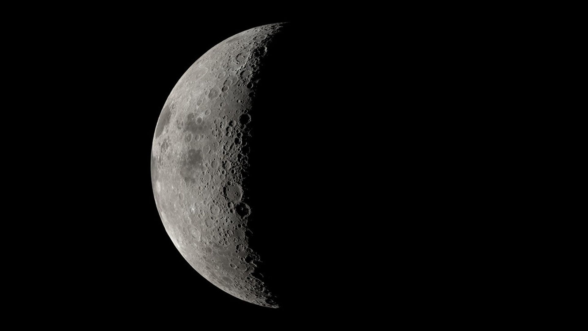
NASA’s Artemis II mission, set to send four astronauts on a nearly 10-day mission around the Moon and back, will advance the agency’s goal to land astronauts at the Moon’s south polar region and will help set the stage for future crewed Mars missions.
While the Artemis II crew will be the first humans to test NASA’s Orion spacecraft in space, they will also conduct science investigations that will inform future deep space missions, including a lunar science investigation as Orion flies about 4,000 to 6,000 miles from the Moon’s surface. From this distance, the Moon will appear to be the size of a basketball held at arm’s length and will provide a unique opportunity for scientific observations.
Artemis II is a chance for astronauts to implement the lunar science skills they’ve developed in training. It’s also an opportunity for scientists and the engineers in mission control to collaborate during real-time operations …Kelsey Young
Artemis II lunar science lead at NASA’s Goddard Space Flight Center in Greenbelt, Maryland.
As Orion passes on the far side of the Moon — the side that always faces away from Earth — the crew will analyze and photograph geologic features on the surface, such as impact craters and ancient lava flows, relying on their extensive geology training in the classroom and in Moon-like places on Earth. The astronauts will also practice describing nuances in shapes, textures, and colors of surface features. This type of information reveals the geologic history of an area and will be critical to collect when Artemis III astronauts explore the surface.
“Artemis II is a chance for astronauts to implement the lunar science skills they’ve developed in training,” said Kelsey Young, Artemis II lunar science lead at NASA’s Goddard Space Flight Center in Greenbelt, Maryland. “It’s also an opportunity for scientists and the engineers in mission control to collaborate during real-time operations, building on the years of testing and simulations that our teams have done together.”
In this May 2024 photo, lunar scientists are working in a mock Science Evaluation Room on the upper floor of the Mission Control Center building at NASA’s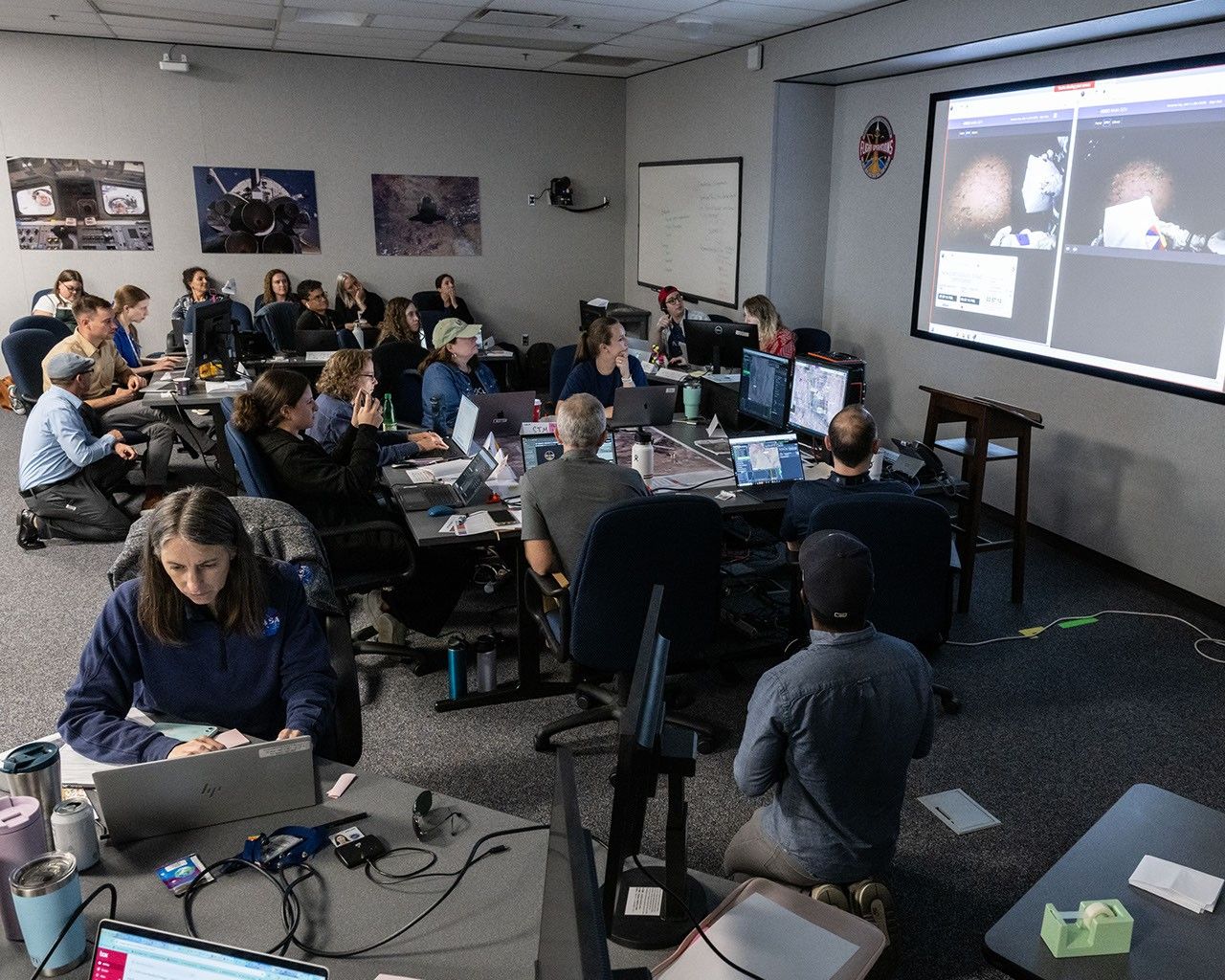
Johnson Space Center in Houston. On the large screens in the background, they are following live as NASA astronauts Kate Rubins and Andre Douglas simulate a moonwalk, in the dark, in northern Arizona’s San Francisco Volcanic Field to help NASA prepare for its Artemis III mission. Scheduled to launch in 2027, Artemis III will land two astronauts at the Moon’s South Pole region. As they did during the 2024 moonwalk simulation, scientists will develop detailed science plans for South Pole moonwalks and provide geology expertise to mission control. NASA/Robert Markowitz
The four Artemis II astronauts, NASA’s Reid Wiseman, Victor Glover, and Christina Koch, and CSA’s (Canadian Space Agency) Jeremy Hansen, could be the first humans to see some parts of the Moon’s far side with the naked eye, depending on the spacecraft’s final trajectory as determined upon launch. During the nine Apollo missions that left Earth’s orbit, astronauts saw parts of the Moon’s far side, but not all of it, as they were limited by which sections were lit during their orbits.
One previously unlit region they may see is the Orientale Basin, a 600-mile-wide crater that serves as a transition point between the near and far side and is sometimes partly visible along the Moon’s western edge.
The astronauts may also get to observe flashes of light from space rocks striking the surface—clues that help reveal how often the Moon gets hit—or dust floating above the edge of the Moon, a mysterious phenomenon scientists want to understand.
To view this video please enable JavaScript, and consider upgrading to a web browser that
supports HTML5 video
The crew’s observations will help pave the way for lunar science activities on future Artemis missions to the Moon’s surface, including Artemis III. Artemis III astronauts will investigate the land forms, rocks, and other features around their landing site. They will also collect rock samples for generations of analyses in Earth labs and set up several instruments to investigate lunar properties and resources — information critical to future human exploration efforts.
“Whether they’re looking out the spacecraft’s windows or walking the surface, Artemis astronauts will be working on behalf of all scientists to collect clues to the ancient geologic processes that shaped the Moon and our solar system,” said Cindy Evans, NASA’s Artemis geology training and strategic integration lead, based at NASA Johnson.
In addition to lunar science observations, the crew will gather data on the effects of the space environment on the crew’s health and performance. These experiments will be managed through the Payload Mission Operations Directorate at NASA’s Marshall Space Flight Center, in Huntsville, Alabama, in tight coordination with mission control. This data could inform long-term lunar exploration and future human missions to Mars.
For more information on Artemis II, visit:
https://www.nasa.gov/mission/artemis-ii/
Related: NASA to Announce New Astronaut Class, Preview Artemis II Moon Mission
Karen Fox / Molly Wasser
Headquarters, Washington
202-358-1600
karen.c.fox@nasa.gov / molly.l.wasser@nasa.gov
Lonnie Shekhtman
NASA’s Goddard Space Flight Center, Greenbelt, Md.
About the Author Lonnie ShekhtmanShare
Details Last Updated Aug 21, 2025 Related Terms Explore More 5 min read Close-Up Views of NASA’s DART Impact to Inform Planetary DefenseArticle
4 hours ago
6 min read Steve Platnick Steps Down from NASA After 34 Years of Service
Article
1 day ago
6 min read NASA, IBM’s ‘Hot’ New AI Model Unlocks Secrets of Sun
Article
1 day ago
Keep Exploring Discover More Topics From NASA
Missions
Humans in Space
Climate Change
Solar System
NASA’s Artemis II Lunar Science Operations to Inform Future Missions
4 min read
NASA’s Artemis II Lunar Science Operations to Inform Future Missions An image of the eastern hemisphere of the Moon as the Artemis II astronauts would see it from an altitude of about 7,000 kilometers. The Moon’s far side is mostly dark in this image, which is based on a simulated trajectory. The dark patches near the center of the sunlit portion are plains of ancient lava: Mare Marginis to the north and Mare Smythii to the south. NASA Goddard/Ernie WrightNASA’s Artemis II mission, set to send four astronauts on a nearly 10-day mission around the Moon and back, will advance the agency’s goal to land astronauts at the Moon’s south polar region and will help set the stage for future crewed Mars missions.
While the Artemis II crew will be the first humans to test NASA’s Orion spacecraft in space, they will also conduct science investigations that will inform future deep space missions, including a lunar science investigation as Orion flies about 4,000 to 6,000 miles from the Moon’s surface. From this distance, the Moon will appear to be the size of a basketball held at arm’s length and will provide a unique opportunity for scientific observations.
Artemis II is a chance for astronauts to implement the lunar science skills they’ve developed in training. It’s also an opportunity for scientists and the engineers in mission control to collaborate during real-time operations …Kelsey Young
Artemis II lunar science lead at NASA’s Goddard Space Flight Center in Greenbelt, Maryland.
As Orion passes on the far side of the Moon — the side that always faces away from Earth — the crew will analyze and photograph geologic features on the surface, such as impact craters and ancient lava flows, relying on their extensive geology training in the classroom and in Moon-like places on Earth. The astronauts will also practice describing nuances in shapes, textures, and colors of surface features. This type of information reveals the geologic history of an area and will be critical to collect when Artemis III astronauts explore the surface.
“Artemis II is a chance for astronauts to implement the lunar science skills they’ve developed in training,” said Kelsey Young, Artemis II lunar science lead at NASA’s Goddard Space Flight Center in Greenbelt, Maryland. “It’s also an opportunity for scientists and the engineers in mission control to collaborate during real-time operations, building on the years of testing and simulations that our teams have done together.”
In this May 2024 photo, lunar scientists are working in a mock Science Evaluation Room on the upper floor of the Mission Control Center building at NASA’sJohnson Space Center in Houston. On the large screens in the background, they are following live as NASA astronauts Kate Rubins and Andre Douglas simulate a moonwalk, in the dark, in northern Arizona’s San Francisco Volcanic Field to help NASA prepare for its Artemis III mission. Scheduled to launch in 2027, Artemis III will land two astronauts at the Moon’s South Pole region. As they did during the 2024 moonwalk simulation, scientists will develop detailed science plans for South Pole moonwalks and provide geology expertise to mission control. NASA/Robert Markowitz
The four Artemis II astronauts, NASA’s Reid Wiseman, Victor Glover, and Christina Koch, and CSA’s (Canadian Space Agency) Jeremy Hansen, could be the first humans to see some parts of the Moon’s far side with the naked eye, depending on the spacecraft’s final trajectory as determined upon launch. During the nine Apollo missions that left Earth’s orbit, astronauts saw parts of the Moon’s far side, but not all of it, as they were limited by which sections were lit during their orbits.
One previously unlit region they may see is the Orientale Basin, a 600-mile-wide crater that serves as a transition point between the near and far side and is sometimes partly visible along the Moon’s western edge.
The astronauts may also get to observe flashes of light from space rocks striking the surface—clues that help reveal how often the Moon gets hit—or dust floating above the edge of the Moon, a mysterious phenomenon scientists want to understand.
To view this video please enable JavaScript, and consider upgrading to a web browser that
supports HTML5 video
The crew’s observations will help pave the way for lunar science activities on future Artemis missions to the Moon’s surface, including Artemis III. Artemis III astronauts will investigate the land forms, rocks, and other features around their landing site. They will also collect rock samples for generations of analyses in Earth labs and set up several instruments to investigate lunar properties and resources — information critical to future human exploration efforts.
“Whether they’re looking out the spacecraft’s windows or walking the surface, Artemis astronauts will be working on behalf of all scientists to collect clues to the ancient geologic processes that shaped the Moon and our solar system,” said Cindy Evans, NASA’s Artemis geology training and strategic integration lead, based at NASA Johnson.
In addition to lunar science observations, the crew will gather data on the effects of the space environment on the crew’s health and performance. These experiments will be managed through the Payload Mission Operations Directorate at NASA’s Marshall Space Flight Center, in Huntsville, Alabama, in tight coordination with mission control. This data could inform long-term lunar exploration and future human missions to Mars.
For more information on Artemis II, visit:
https://www.nasa.gov/mission/artemis-ii/
Related: NASA to Announce New Astronaut Class, Preview Artemis II Moon Mission
Karen Fox / Molly Wasser
Headquarters, Washington
202-358-1600
karen.c.fox@nasa.gov / molly.l.wasser@nasa.gov
Lonnie Shekhtman
NASA’s Goddard Space Flight Center, Greenbelt, Md.
About the Author Lonnie ShekhtmanShare
Details Last Updated Aug 21, 2025 Related Terms Explore More 5 min read Close-Up Views of NASA’s DART Impact to Inform Planetary DefenseArticle
4 hours ago
6 min read Steve Platnick Steps Down from NASA After 34 Years of Service
Article
1 day ago
6 min read NASA, IBM’s ‘Hot’ New AI Model Unlocks Secrets of Sun
Article
1 day ago
Keep Exploring Discover More Topics From NASA
Missions
Humans in Space
Climate Change
Solar System
La NASA invita a los medios al lanzamiento conjunto de misiones sobre el Sol y la meteorología espacial
Read this release in English here.
La NASA ha abierto el plazo para la acreditación de los medios para el lanzamiento de tres observatorios que estudiarán el Sol y mejorarán nuestra capacidad de hacer pronósticos precisos de meteorología espacial, ayudando a proteger los sistemas tecnológicos que impactan la vida en la Tierra.
La NASA tiene previsto lanzar, no antes del martes 23 de septiembre, la sonda IMAP (por las siglas en inglés de Sonda de Cartografía y Aceleración Interestelar) de la agencia, el Observatorio Carruthers de la Geocorona y el observatorio Seguimiento de la Meteorología Espacial–Lagrange 1 (SWFO-L1, por su acrónimo en inglés) de la Administración Nacional Oceánica y Atmosférica (NOAA, por sus siglas en inglés). Los observatorios se lanzarán a bordo de un cohete SpaceX Falcon 9 desde el Complejo de Lanzamiento 39A del Centro Espacial Kennedy de la NASA en Florida.
Los medios acreditados tendrán la oportunidad de participar en sesiones informativas previas al lanzamiento y entrevistas con miembros clave de la misión antes del lanzamiento, así como de cubrir el lanzamiento. La NASA comunicará más detalles sobre el calendario de eventos para los medios de comunicación a medida que se acerque la fecha del lanzamiento.
Las fechas límites de acreditación de medios para el lanzamiento son:
- Los miembros de medios de comunicación sin ciudadanía estadounidense deben enviar su solicitud a más tardar a las 11:59 p.m. EDT del domingo, 31 de agosto.
- Los miembros de medios de comunicación con ciudadanía estadounidense deben enviar su solicitud a más tardar a las 11:59 p.m. EDT del jueves, 4 de septiembre.
Todas las solicitudes de acreditación deben enviarse en línea en:
La política de acreditación de medios de la NASA está disponible en línea. Si tiene preguntas sobre el proceso de acreditación, por favor envíelas a: ksc-media-accreditat@mail.nasa.gov. Para otras preguntas, por favor póngase en contacto con el centro de prensa del centro Kennedy de la NASA: +1 321-867-2468.
Para obtener información en español en sobre el Centro Espacial Kennedy, comuníquese con Antonia Jaramillo: 321-501-8425. Si desea solicitar entrevistas en español sobre IMAP, póngase en contacto con María-José Viñas: maria-jose.vinasgarcia@nasa.gov.
La sonda IMAP de la NASA utilizará diez instrumentos científicos para estudiar y mapear la heliosfera, una vasta burbuja magnética que rodea al Sol y protege nuestro sistema solar de la radiación proveniente del espacio interestelar. Esta misión y sus dos compañeros de viaje orbitarán el Sol cerca del punto de Lagrange 1, a aproximadamente 1,6 millones de kilómetros (un millón de millas) de la Tierra, donde escaneará la heliosfera, analizará la composición de partículas cargadas e investigará cómo esas partículas se mueven a través del sistema solar. Esto proporcionará información sobre cómo el Sol acelera las partículas cargadas, aportando información esencial para comprender el entorno meteorológico espacial en todo el sistema solar. IMAP también monitoreará continuamente el viento solar y la radiación cósmica. La comunidad científica podrá usar estos datos para evaluar capacidades nuevas y mejoradas para herramientas y modelos de predicción de la meteorología espacial, que son vitales para la salud de los humanos que exploran el espacio y la longevidad de sistemas tecnológicos, como satélites y redes eléctricas, que pueden afectar la vida en la Tierra.
El Observatorio Carruthers de la Geocorona de la agencia es un pequeño satélite concebido para estudiar la exosfera, la parte más externa de la atmósfera de la Tierra. Utilizando cámaras ultravioletas, monitoreará cómo la meteorología espacial del Sol impacta la exosfera, la cual juega un papel crucial en la protección de la Tierra contra eventos de meteorología espacial que pueden afectar satélites, comunicaciones y líneas eléctricas. La exosfera, una nube de hidrógeno neutro que se extiende hasta la Luna y posiblemente más allá, se crea por la descomposición del agua y el metano por la luz ultravioleta del Sol, y su brillo, conocido como la geocorona, solo se ha observado a nivel mundial cuatro veces antes de esta misión.
La misión SWFO-L1, gestionada por la NOAA y desarrollada con el Centro de Vuelo Espacial Goddard de NASA en Greenbelt, Maryland, y socios comerciales, utilizará un conjunto de instrumentos para proporcionar mediciones en tiempo real del viento solar, junto con un coronógrafo compacto para detectar eyecciones de masa coronal del Sol. El observatorio, que sirve como baliza de alerta temprana para fenómenos meteorológicos espaciales potencialmente destructivos, permitirá pronósticos más rápidos y precisos. Sus datos, disponibles las 24 horas del día, los 7 días de la semana, ayudarán al Centro de Predicción Meteorológica Espacial de la NOAA a proteger infraestructuras vitales, intereses económicos y la seguridad nacional, tanto en la Tierra como en el espacio.
David McComas, profesor de la Universidad de Princeton, lidera la misión IMAP con un equipo internacional de 25 instituciones asociadas. El Laboratorio de Física Aplicada Johns Hopkins en Laurel, Maryland, construyó la nave espacial y opera la misión. IMAP de la NASA es la quinta misión en el portafolio del programa de Sondas Solares Terrestres de la NASA. La División de Exploradores y Proyectos de Heliofísica en el centro Goddard de la NASA gestiona el programa para la División de Heliofísica de la Dirección de Misiones Científicas de la NASA.
Para más detalles (en inglés) sobre la misión IMAP y actualizaciones sobre los preparativos de lanzamiento, visite:
https://science.nasa.gov/mission/imap/
-fin-
Abbey Interrante / María José Viñas
Sede central de la NASA, Washington
301-201-0124
abbey.a.interrante@nasa.gov / maria-jose.vinasgarcia@nasa.gov
Sarah Frazier
Centro de Vuelo Espacial Goddard, Greenbelt, Md.
202-853-7191
sarah.frazier@nasa.gov
Leejay Lockhart
Centro Espacial Kennedy, Fla.
321-747-8310
leejay.lockhart@nasa.gov
John Jones-Bateman
Servicio de Satélites e Información de la NOAA, Silver Spring, Md.
202-242-0929
john.jones-bateman@noaa.gov
Black Moon darkens August skies — here's how to hunt sparking wonders in the Milky Way this weekend
Cities by the Bay
Cities by the Bay
NASA astronaut Nichole Ayers took this photo of California’s San Francisco Bay Area surrounded by the cities of San Francisco, Oakland, and San Jose, and their suburbs on Aug. 3, 2025. At the time, the International Space Station orbited 260 miles above the Golden State.
The International Space Station serves as a unique platform for observing Earth with both hands-on and automated equipment. Station crew members have produced hundreds of thousands of images, recording phenomena such as storms in real time, observing natural events such as volcanic eruptions as they happen, and providing input to ground personnel for programming automated Earth-sensing systems.
In its third decade of continuous human presence, the space station has a far-reaching impact as a microgravity lab hosting technology, demonstrations, and scientific investigations from a range of fields. The research done on the orbiting laboratory will inform long-duration missions like Artemis and future human expeditions to Mars.
Learn more about Earth observation from the space station.
Image credit: NASA/Nichole Ayers
JWST Discovers New Moon of Uranus
Astronomers have spotted a new small moon for Uranus in images from earlier this year.
The post JWST Discovers New Moon of Uranus appeared first on Sky & Telescope.
Astronomers trace massive cosmic explosion back 12 billion years. 'This is the most distant event where we can directly see light escaping from around stars'
Close-Up Views of NASA’s DART Impact to Inform Planetary Defense
5 min read
Close-Up Views of NASA’s DART Impact to Inform Planetary Defense Photos taken by the Italian LICIACube, short for the LICIA CubeSat for Imaging of Asteroids. These offer the closest, most detailed observations of NASA’s DART (Double Asteroid Redirection Test) impact aftermath to date. The photo on the left was taken roughly 2 minutes and 40 seconds after impact, as the satellite flew past the Didymos system. The photo on the right was taken 20 seconds later, as LICIACube was leaving the scene. The larger body, near the top of each image is Didymos. The smaller body in the lower half of each image is Dimorphos, enveloped by the cloud of rocky debris created by DART’s impact. NASA/ASI/University of Maryland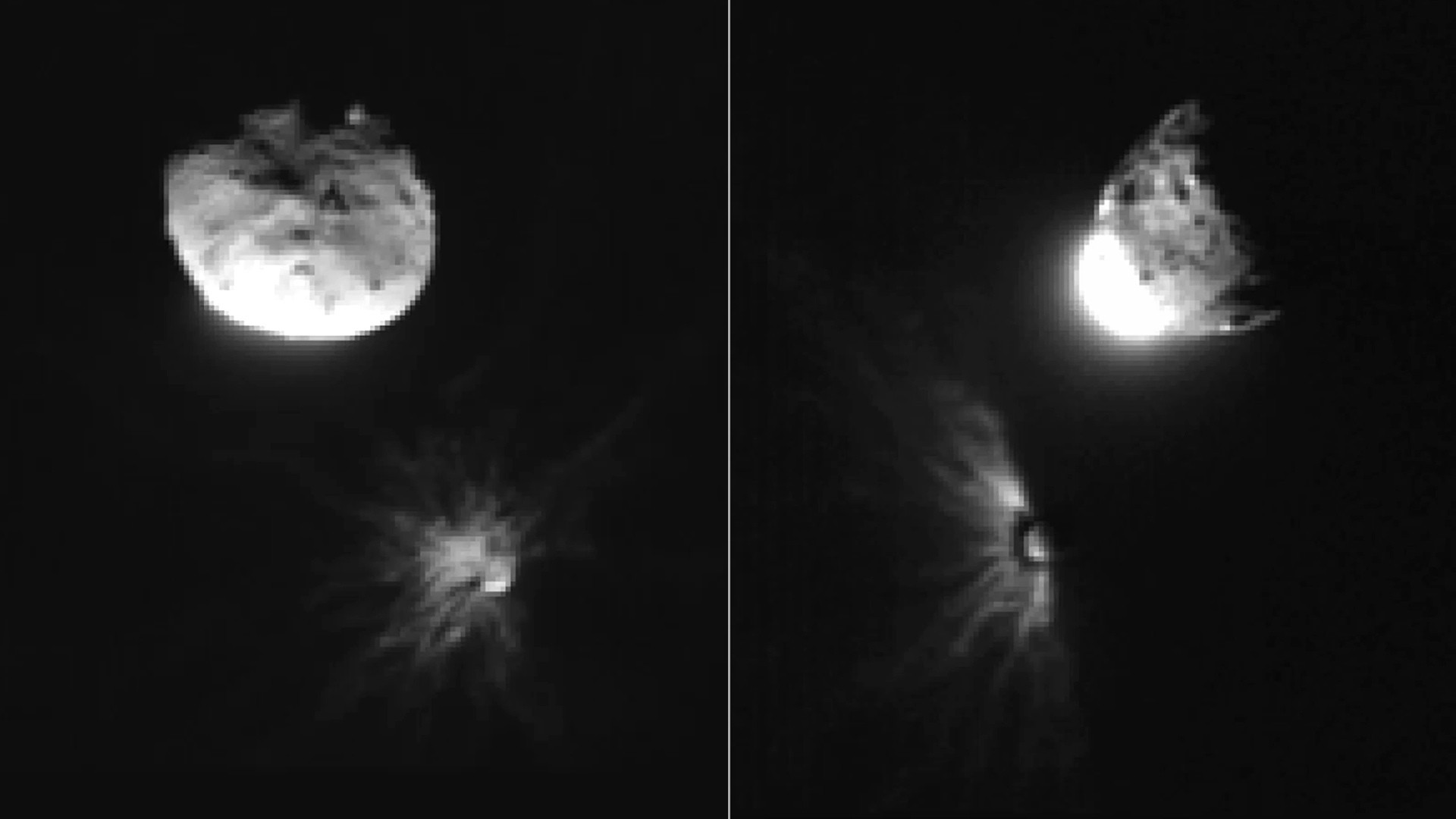
On Sept. 11, 2022, engineers at a flight control center in Turin, Italy, sent a radio signal into deep space. Its destination was NASA’s DART (Double Asteroid Redirection Test) spacecraft flying toward an asteroid more than 5 million miles away.
The message prompted the spacecraft to execute a series of pre-programmed commands that caused a small, shoebox-sized satellite contributed by the Italian Space Agency (ASI), called LICIACube, to detach from DART.
Fifteen days later, when DART’s journey ended in an intentional head-on collision with near-Earth asteroid Dimorphos, LICIACube flew past the asteroid to snap a series of photos, providing researchers with the only on-site observations of the world’s first demonstration of an asteroid deflection.
After analyzing LICIACube’s images, NASA and ASI scientists report on Aug. 21 in the Planetary Science Journal that an estimated 35.3 million pounds (16 million kilograms) of dust and rocks spewed from the asteroid as a result of the crash, refining previous estimates that were based on data from ground and space-based observations.
While the debris shed from the asteroid amounted to less than 0.5% of its total mass, it was still 30,000 times greater than the mass of the spacecraft. The impact of the debris on Dimorphos’ trajectory was dramatic: shortly after the collision, the DART team determined that the flying rubble gave Dimorphos a shove several times stronger than the hit from the spacecraft itself.
“The plume of material released from the asteroid was like a short burst from a rocket engine,” said Ramin Lolachi, a research scientist who led the study from NASA’s Goddard Space Flight Center in Greenbelt, Maryland.
The important takeaway from the DART mission is that a small, lightweight spacecraft can dramatically alter the path of an asteroid of similar size and composition to Dimorphos, which is a “rubble-pile” asteroid — or a loose, porous collection of rocky material bound together weakly by gravity.
“We expect that a lot of near-Earth asteroids have a similar structure to Dimorphos,” said Dave Glenar, a planetary scientist at the University of Maryland, Baltimore County, who participated in the study. “So, this extra push from the debris plume is critical to consider when building future spacecraft to deflect asteroids from Earth.”
NASA chose Dimorphos, which poses no threat to Earth, as the mission target due to its relationship with another, larger asteroid named Didymos. Dimorphos orbits Didymos in a binary asteroid system, much like the Moon orbits Earth. Critically, the pair’s position relative to Earth allowed astronomers to measure the duration of the moonlet’s orbit before and after the collision.
Ground and space-based observations revealed that DART shortened Dimorphos’ orbit by 33 minutes. But these long-range observations, made from 6.8 million miles (10.9 million kilometers) away, were too distant to support a detailed study of the impact debris. That was LICIACube’s job.
After DART’s impact, LICIACube had just 60 seconds to make its most critical observations. Barreling past the asteroid at 15,000 miles (21,140 kilometers) per hour, the spacecraft took a snapshot of the debris roughly once every three seconds. Its closest image was taken just 53 miles (85.3 km) from Dimorphos’ surface.
The short distance between LICIACube and Dimorphos provided a unique advantage, allowing the cubesat to capture detailed images of the dusty debris from multiple angles.
The research team studied a series of 18 LICIAcube images. The first images in the sequence showed LICIACube’s head-on approach. From this angle, the plume was brightly illuminated by direct sunlight. As the spacecraft glided past the asteroid, its camera pivoted to keep the plume in view.
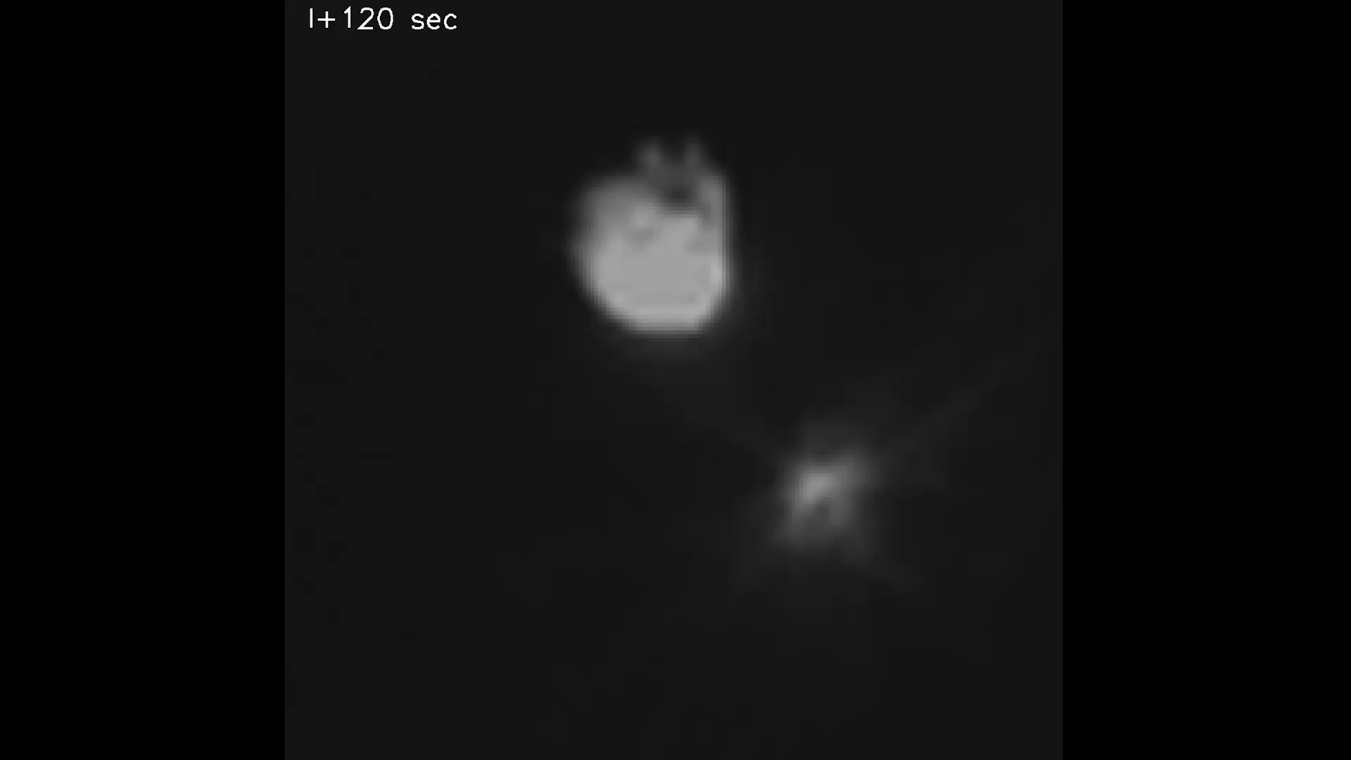
As LICIACube looked back at the asteroid, sunlight filtered through the dense cloud of debris, and the plume’s brightness faded. This suggested the plume was made of mostly large particles — about a millimeter or more across — which reflect less light than tiny dust grains.
Since the innermost parts of the plume were so thick with debris that they were completely opaque, the scientists used models to estimate the number of particles that were hidden from view. Data from other rubble-pile asteroids, including pieces of Bennu delivered to Earth in 2023 by NASA’s OSIRIS-REx spacecraft, and laboratory experiments helped refine the estimate.
“We estimated that this hidden material accounted for almost 45% of the plume’s total mass,” said Timothy Stubbs, a planetary scientist at NASA Goddard who was involved with the study.
While DART showed that a high-speed collision with a spacecraft can change an asteroid’s trajectory, Stubbs and his colleagues note that different asteroid types, such as those made of stronger, more tightly packed material, might respond differently to a DART-like impact. “Every time we interact with an asteroid, we find something that surprises us, so there’s a lot more work to do,” said Stubbs. “But DART is a big step forward for planetary defense.”
The Johns Hopkins Applied Physics Laboratory in Laurel, Maryland, managed the DART mission and operated the spacecraft for NASA’s Planetary Defense Coordination Office as a project of the agency’s Planetary Missions Program Office.
By Nathan Marder, nathan.marder@nasa.gov
NASA’s Goddard Space Flight Center, Greenbelt, Md.
While the Artemis II crew will be the first humans to test NASA’s Orion spacecraft…
Article
3 hours ago
6 min read NASA, IBM’s ‘Hot’ New AI Model Unlocks Secrets of Sun
Article
1 day ago
3 min read Summer Triangle Corner: Altair
Article
6 days ago
Keep Exploring Discover Related Topics
Double Asteroid Redirection Test (DART)
Asteroids, Comets & Meteors
Our Solar System
For Planetary Science Researchers
Resources specifically curated to help planetary science researchers, whether new to the field or seasoned professionals.
Close-Up Views of NASA’s DART Impact to Inform Planetary Defense
5 min read
Close-Up Views of NASA’s DART Impact to Inform Planetary Defense Photos taken by the Italian LICIACube, short for the LICIA CubeSat for Imaging of Asteroids. These offer the closest, most detailed observations of NASA’s DART (Double Asteroid Redirection Test) impact aftermath to date. The photo on the left was taken roughly 2 minutes and 40 seconds after impact, as the satellite flew past the Didymos system. The photo on the right was taken 20 seconds later, as LICIACube was leaving the scene. The larger body, near the top of each image is Didymos. The smaller body in the lower half of each image is Dimorphos, enveloped by the cloud of rocky debris created by DART’s impact. NASA/ASI/University of MarylandOn Sept. 11, 2022, engineers at a flight control center in Turin, Italy, sent a radio signal into deep space. Its destination was NASA’s DART (Double Asteroid Redirection Test) spacecraft flying toward an asteroid more than 5 million miles away.
The message prompted the spacecraft to execute a series of pre-programmed commands that caused a small, shoebox-sized satellite contributed by the Italian Space Agency (ASI), called LICIACube, to detach from DART.
Fifteen days later, when DART’s journey ended in an intentional head-on collision with near-Earth asteroid Dimorphos, LICIACube flew past the asteroid to snap a series of photos, providing researchers with the only on-site observations of the world’s first demonstration of an asteroid deflection.
After analyzing LICIACube’s images, NASA and ASI scientists report on Aug. 21 in the Planetary Science Journal that an estimated 35.3 million pounds (16 million kilograms) of dust and rocks spewed from the asteroid as a result of the crash, refining previous estimates that were based on data from ground and space-based observations.
While the debris shed from the asteroid amounted to less than 0.5% of its total mass, it was still 30,000 times greater than the mass of the spacecraft. The impact of the debris on Dimorphos’ trajectory was dramatic: shortly after the collision, the DART team determined that the flying rubble gave Dimorphos a shove several times stronger than the hit from the spacecraft itself.
“The plume of material released from the asteroid was like a short burst from a rocket engine,” said Ramin Lolachi, a research scientist who led the study from NASA’s Goddard Space Flight Center in Greenbelt, Maryland.
The important takeaway from the DART mission is that a small, lightweight spacecraft can dramatically alter the path of an asteroid of similar size and composition to Dimorphos, which is a “rubble-pile” asteroid — or a loose, porous collection of rocky material bound together weakly by gravity.
“We expect that a lot of near-Earth asteroids have a similar structure to Dimorphos,” said Dave Glenar, a planetary scientist at the University of Maryland, Baltimore County, who participated in the study. “So, this extra push from the debris plume is critical to consider when building future spacecraft to deflect asteroids from Earth.”
NASA chose Dimorphos, which poses no threat to Earth, as the mission target due to its relationship with another, larger asteroid named Didymos. Dimorphos orbits Didymos in a binary asteroid system, much like the Moon orbits Earth. Critically, the pair’s position relative to Earth allowed astronomers to measure the duration of the moonlet’s orbit before and after the collision.
Ground and space-based observations revealed that DART shortened Dimorphos’ orbit by 33 minutes. But these long-range observations, made from 6.8 million miles (10.9 million kilometers) away, were too distant to support a detailed study of the impact debris. That was LICIACube’s job.
After DART’s impact, LICIACube had just 60 seconds to make its most critical observations. Barreling past the asteroid at 15,000 miles (21,140 kilometers) per hour, the spacecraft took a snapshot of the debris roughly once every three seconds. Its closest image was taken just 53 miles (85.3 km) from Dimorphos’ surface.
The short distance between LICIACube and Dimorphos provided a unique advantage, allowing the cubesat to capture detailed images of the dusty debris from multiple angles.
The research team studied a series of 18 LICIAcube images. The first images in the sequence showed LICIACube’s head-on approach. From this angle, the plume was brightly illuminated by direct sunlight. As the spacecraft glided past the asteroid, its camera pivoted to keep the plume in view.
As LICIACube looked back at the asteroid, sunlight filtered through the dense cloud of debris, and the plume’s brightness faded. This suggested the plume was made of mostly large particles — about a millimeter or more across — which reflect less light than tiny dust grains.
Since the innermost parts of the plume were so thick with debris that they were completely opaque, the scientists used models to estimate the number of particles that were hidden from view. Data from other rubble-pile asteroids, including pieces of Bennu delivered to Earth in 2023 by NASA’s OSIRIS-REx spacecraft, and laboratory experiments helped refine the estimate.
“We estimated that this hidden material accounted for almost 45% of the plume’s total mass,” said Timothy Stubbs, a planetary scientist at NASA Goddard who was involved with the study.
While DART showed that a high-speed collision with a spacecraft can change an asteroid’s trajectory, Stubbs and his colleagues note that different asteroid types, such as those made of stronger, more tightly packed material, might respond differently to a DART-like impact. “Every time we interact with an asteroid, we find something that surprises us, so there’s a lot more work to do,” said Stubbs. “But DART is a big step forward for planetary defense.”
The Johns Hopkins Applied Physics Laboratory in Laurel, Maryland, managed the DART mission and operated the spacecraft for NASA’s Planetary Defense Coordination Office as a project of the agency’s Planetary Missions Program Office.
By Nathan Marder, nathan.marder@nasa.gov
NASA’s Goddard Space Flight Center, Greenbelt, Md.
While the Artemis II crew will be the first humans to test NASA’s Orion spacecraft…
Article
3 hours ago
6 min read NASA, IBM’s ‘Hot’ New AI Model Unlocks Secrets of Sun
Article
1 day ago
3 min read Summer Triangle Corner: Altair
Article
6 days ago
Keep Exploring Discover Related Topics
Double Asteroid Redirection Test (DART)
Asteroids, Comets & Meteors
Our Solar System
For Planetary Science Researchers
Resources specifically curated to help planetary science researchers, whether new to the field or seasoned professionals.
There might be a 'Planet Y' hiding in the outer solar system
There might be a 'Planet Y' hiding in the outer solar system
NASA Invites Media to Joint Launch of Sun, Space Weather Missions
Lee esta nota de prensa en español aquí.
Media accreditation is open for the launch of three observatories that will study the Sun and enhance the ability to make accurate space weather forecasts, helping protect technology systems that affect life on Earth.
NASA is targeting no earlier than Tuesday, Sept. 23, for the launch of the agency’s IMAP (Interstellar Mapping and Acceleration Probe), the Carruthers Geocorona Observatory, and National Oceanic and Atmospheric Administration’s (NOAA) Space Weather Follow On–Lagrange 1 (SWFO-L1) observatory. The observatories will launch aboard a SpaceX Falcon 9 rocket from Launch Complex 39A at NASA’s Kennedy Space Center in Florida.
Accredited media will have the opportunity to participate in prelaunch briefings and interviews with key mission personnel prior to launch, as well as cover the launch. NASA will communicate additional details regarding the media event schedule as the launch date approaches.
Media accreditation deadlines for the launch are as follows:
- International media without U.S. citizenship must apply by 11:59 p.m. EDT on Sunday, Aug. 31.
- U.S. media and U.S. citizens representing international media organizations must apply by 11:59 p.m. on Thursday, Sept. 4.
All accreditation requests must be submitted online at:
NASA’s media accreditation policy is available online. For questions about accreditation, please email: ksc-media-accreditat@mail.nasa.gov. For other mission questions, please contact the NASA Kennedy newsroom at 321-867-2468.
Para obtener información en español en sobre el Centro Espacial Kennedy, comuníquese con Antonia Jaramillo: 321-501-8425. Si desea solicitar entrevistas en español sobre IMAP, póngase en contacto con María-José Viñas: maria-jose.vinasgarcia@nasa.gov.
NASA’s IMAP will use 10 science instruments to study and map the heliosphere, a vast magnetic bubble surrounding the Sun protecting our solar system from radiation incoming from interstellar space. This mission and its two rideshares will orbit the Sun near Lagrange point 1, about one million miles from Earth, where it will scan the heliosphere, analyze the composition of charged particles, and investigate how those particles move through the solar system. This will provide information on how the Sun accelerates charged particles, filling in essential puzzle pieces to understand the space weather environment across the solar system. The IMAP spacecraft also will continuously monitor solar wind and cosmic radiation. Scientists can use this information to evaluate new and improved capabilities for space weather prediction tools and models, which are vital for the health of human space explorers and the longevity of technological systems, like satellites and power grids, that can affect life on Earth.
The agency’s Carruthers Geocorona Observatory is a small satellite set to study the exosphere, the outermost part of Earth’s atmosphere. Using ultraviolet cameras, it will monitor how space weather from the Sun impacts the exosphere, which plays a crucial role in protecting Earth from space weather events that can affect satellites, communications, and power lines. The exosphere, a cloud of neutral hydrogen extending to the Moon and possibly beyond, is created by the breakdown of water and methane by ultraviolet light from the Sun, and its glow, known as the geocorona, has been observed globally only four times before this mission.
The SWFO-L1 mission, managed by NOAA and developed with NASA’s Goddard Space Flight Center in Greenbelt, Maryland, and commercial partners, will use a suite of instruments to provide real-time measurements of solar wind, along with a compact coronagraph to detect coronal mass ejections from the Sun. The observatory, serving as an early warning beacon for potentially destructive space weather events, will enable faster and more accurate forecasts. Its 24/7 data will support NOAA’s Space Weather Prediction Center in protecting vital infrastructure, economic interests, and national security, both on Earth and in space.
David McComas, professor, Princeton University, leads the IMAP mission with an international team of 25 partner institutions. The Johns Hopkins Applied Physics Laboratory in Laurel, Maryland, built the spacecraft and operates the mission. NASA’s IMAP is the fifth mission in NASA’s Solar Terrestrial Probes program portfolio. The Explorers and Heliophysics Project Division at NASA Goddard manages the program for the agency’s Heliophysics Division of NASA’s Science Mission Directorate.
NASA’s Launch Services Program, based at NASA Kennedy, manages the launch service for the mission.
For more details about the IMAP mission and updates on launch preparations, visit:
https://science.nasa.gov/mission/imap/
-end-
Abbey Interrante
Headquarters, Washington
301-201-0124
abbey.a.interrante@nasa.gov
Sarah Frazier
Goddard Space Flight Center, Greenbelt, Md.
202-853-7191
sarah.frazier@nasa.gov
Leejay Lockhart
Kennedy Space Center, Fla.
321-747-8310
leejay.lockhart@nasa.gov
John Jones-Bateman
NOAA’s Satellite and Information Service, Silver Spring, Md.
202-242-0929
john.jones-bateman@noaa.gov
Reining in the sun: Venus, Earth and Jupiter may work together to reduce the risk of extreme solar storms
The Serpentine Apep Nebula, Imaged by the Webb Telescope
The James Webb Space Telescope shows intriguing new details in the Apep Nebula, created by the colliding winds of two dying stars.
The post The Serpentine Apep Nebula, Imaged by the Webb Telescope appeared first on Sky & Telescope.