
Feed aggregator
Ancient humans were seafaring far earlier than we realised
Huge fossil bonanza preserves 512-million-year-old ecosystem
Huge fossil bonanza preserves 512-million-year-old ecosystem
NASA Webb Pushes Boundaries of Observable Universe Closer to Big Bang
- Webb
- News
- Overview
- Science
- Observatory
- Multimedia
- Team
- More
NASA’s James Webb Space Telescope has topped itself once again, delivering on its promise to push the boundaries of the observable universe closer to cosmic dawn with the confirmation of a bright galaxy that existed 280 million years after the big bang. By now Webb has established that it will eventually surpass virtually every benchmark it sets in these early years, but the newly confirmed galaxy, MoM-z14, holds intriguing clues to the universe’s historical timeline and just how different a place the early universe was than astronomers expected.
“With Webb, we are able to see farther than humans ever have before, and it looks nothing like what we predicted, which is both challenging and exciting,” said Rohan Naidu of the Massachusetts Institute of Technology’s (MIT) Kavli Institute for Astrophysics and Space Research, lead author of a paper on galaxy MoM-z14 published in the Open Journal of Astrophysics.
Due to the expansion of the universe that is driven by dark energy, discussion of physical distances and “years ago” becomes tricky when looking this far. Using Webb’s NIRSpec (Near-Infrared Spectrograph) instrument, astronomers confirmed that MoM-z14 has a cosmological redshift of 14.44, meaning that its light has been travelling through (expanding) space, being stretched and “shifted” to longer, redder wavelengths, for about 13.5 of the universe’s estimated 13.8 billion years of existence.
“We can estimate the distance of galaxies from images, but it’s really important to follow up and confirm with more detailed spectroscopy so that we know exactly what we are seeing, and when,” said Pascal Oesch of the University of Geneva, co-principal investigator of the survey.
Image: COSMOS Field MoM-z14 Galaxy (NIRCam Image) NASA’s James Webb Space Telescope shows galaxy MoM-z14 as it appeared in the distant past, only 280 million years after the universe began in the big bang. Image: NASA, ESA, CSA, STScI, Rohan Naidu (MIT); Image Processing: Joseph DePasquale (STScI) Intriguing Features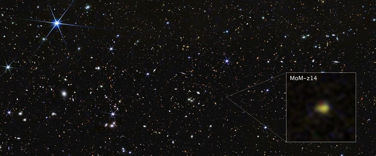
MoM-z14 is one of a growing group of surprisingly bright galaxies in the early universe – 100 times more than theoretical studies predicted before the launch of Webb, according to the research team.
“There is a growing chasm between theory and observation related to the early universe, which presents compelling questions to be explored going forward,” said Jacob Shen, a postdoctoral researcher at MIT and a member of the research team.
One place researchers and theorists can look for answers is the oldest population of stars in the Milky Way galaxy. A small percentage of these stars have shown high amounts of nitrogen, which is also showing up in some of Webb’s observations of early galaxies, including MoM-z14.
“We can take a page from archeology and look at these ancient stars in our own galaxy like fossils from the early universe, except in astronomy we are lucky enough to have Webb seeing so far that we also have direct information about galaxies during that time. It turns out we are seeing some of the same features, like this unusual nitrogen enrichment,” said Naidu.
With galaxy MoM-z14 existing only 280 million years after the big bang, there was not enough time for generations of stars to produce such high amounts of nitrogen in the way that astronomers would expect. One theory the researchers note is that the dense environment of the early universe resulted in supermassive stars capable of producing more nitrogen than any stars observed in the local universe.
The galaxy MoM-z14 also shows signs of clearing out the thick, primordial hydrogen fog of the early universe in the space around itself. One of the reasons Webb was originally built was to define the timeline for this “clearing” period of cosmic history, which astronomers call reionization. This is when early stars produced light of high enough energy to break through the dense hydrogen gas of the early universe and begin travelling through space, eventually making its way to Webb, and us. Galaxy MoM-z14 provides another clue for mapping out the timeline of reionization, work that was not possible until Webb lifted the veil on this era of the universe.
Legacy of Discovery ContinuesEven before Webb’s launch, there were hints that something very unanticipated happened in the early universe, when NASA’s Hubble Space Telescope discovered the bright galaxy GN-z11 400 million years after the big bang. Webb confirmed the galaxy’s distance — at the time the most distant ever. From there Webb has continued to push back farther and farther in space and time, finding more surprisingly bright galaxies like GN-z11.
As Webb continues to uncover more of these unexpectedly luminous galaxies, it’s clear that the first few were not a fluke. Astronomers are eagerly anticipating that NASA’s upcoming Nancy Grace Roman Space Telescope, with its combination of high-resolution infrared imaging and extremely wide field of view, will boost the sample of these bright, compact, chemically enriched early galaxies into the thousands.
“To figure out what is going on in the early universe, we really need more information —more detailed observations with Webb, and more galaxies to see where the common features are, which Roman will be able to provide,” said Yijia Li, a graduate student at the Pennsylvania State University and a member of the research team. “It’s an incredibly exciting time, with Webb revealing the early universe like never before and showing us how much there still is to discover.”
The James Webb Space Telescope is the world’s premier space science observatory. Webb is solving mysteries in our solar system, looking beyond to distant worlds around other stars, and probing the mysterious structures and origins of our universe and our place in it. Webb is an international program led by NASA with its partners, ESA (European Space Agency) and CSA (Canadian Space Agency).
To learn more about Webb, visit:
Downloads & Related InformationThe following sections contain links to download this article’s images and videos in all available resolutions followed by related information links, media contacts, and if available, research paper and Spanish translation links.
Related Images & Videos COSMOS Field MoM-z14 Galaxy (NIRCam Image)NASA’s James Webb Space Telescope shows galaxy MoM-z14 as it appeared in the distant past, only 280 million years after the universe began in the big bang.
COSMOS Field MoM-z14 Galaxy (NIRCam Compass Image)NASA’s James Webb Space Telescope shows galaxy MoM-z14 as it appeared in the distant past, only 280 million years after the universe began in the big bang.
Related LinksRead more: Webb Science: Galaxies Through Time
Explore more: ViewSpace Seeing Farther: Hubble Ultra Deep Field
Video: JADES: GOODS South Fly-Through Visualization
Video: Ultra Deep Field: Looking Out into Space, Looking Back into Time
Explore more: ViewSpace Gathering Light: Hubble Ultra Deep Field
Share Details Last Updated Jan 28, 2026 LocationNASA Goddard Space Flight Center Contact MediaLaura Betz
NASA’s Goddard Space Flight Center
Greenbelt, Maryland
laura.e.betz@nasa.gov
Leah Ramsay
Space Telescope Science Institute
Baltimore, Maryland
Christine Pulliam
Space Telescope Science Institute
Baltimore, Maryland
Webb is the premier observatory of the next decade, serving thousands of astronomers worldwide. It studies every phase in the…
Galaxies
Galaxies Stories
Universe
NASA Webb Pushes Boundaries of Observable Universe Closer to Big Bang
- Webb
- News
- Overview
- Science
- Observatory
- Multimedia
- Team
- More
NASA’s James Webb Space Telescope has topped itself once again, delivering on its promise to push the boundaries of the observable universe closer to cosmic dawn with the confirmation of a bright galaxy that existed 280 million years after the big bang. By now Webb has established that it will eventually surpass virtually every benchmark it sets in these early years, but the newly confirmed galaxy, MoM-z14, holds intriguing clues to the universe’s historical timeline and just how different a place the early universe was than astronomers expected.
“With Webb, we are able to see farther than humans ever have before, and it looks nothing like what we predicted, which is both challenging and exciting,” said Rohan Naidu of the Massachusetts Institute of Technology’s (MIT) Kavli Institute for Astrophysics and Space Research, lead author of a paper on galaxy MoM-z14 published in the Open Journal of Astrophysics.
Due to the expansion of the universe that is driven by dark energy, discussion of physical distances and “years ago” becomes tricky when looking this far. Using Webb’s NIRSpec (Near-Infrared Spectrograph) instrument, astronomers confirmed that MoM-z14 has a cosmological redshift of 14.44, meaning that its light has been travelling through (expanding) space, being stretched and “shifted” to longer, redder wavelengths, for about 13.5 of the universe’s estimated 13.8 billion years of existence.
“We can estimate the distance of galaxies from images, but it’s really important to follow up and confirm with more detailed spectroscopy so that we know exactly what we are seeing, and when,” said Pascal Oesch of the University of Geneva, co-principal investigator of the survey.
Image: COSMOS Field MoM-z14 Galaxy (NIRCam Image) NASA’s James Webb Space Telescope shows galaxy MoM-z14 as it appeared in the distant past, only 280 million years after the universe began in the big bang. Image: NASA, ESA, CSA, STScI, Rohan Naidu (MIT); Image Processing: Joseph DePasquale (STScI) Intriguing FeaturesMoM-z14 is one of a growing group of surprisingly bright galaxies in the early universe – 100 times more than theoretical studies predicted before the launch of Webb, according to the research team.
“There is a growing chasm between theory and observation related to the early universe, which presents compelling questions to be explored going forward,” said Jacob Shen, a postdoctoral researcher at MIT and a member of the research team.
One place researchers and theorists can look for answers is the oldest population of stars in the Milky Way galaxy. A small percentage of these stars have shown high amounts of nitrogen, which is also showing up in some of Webb’s observations of early galaxies, including MoM-z14.
“We can take a page from archeology and look at these ancient stars in our own galaxy like fossils from the early universe, except in astronomy we are lucky enough to have Webb seeing so far that we also have direct information about galaxies during that time. It turns out we are seeing some of the same features, like this unusual nitrogen enrichment,” said Naidu.
With galaxy MoM-z14 existing only 280 million years after the big bang, there was not enough time for generations of stars to produce such high amounts of nitrogen in the way that astronomers would expect. One theory the researchers note is that the dense environment of the early universe resulted in supermassive stars capable of producing more nitrogen than any stars observed in the local universe.
The galaxy MoM-z14 also shows signs of clearing out the thick, primordial hydrogen fog of the early universe in the space around itself. One of the reasons Webb was originally built was to define the timeline for this “clearing” period of cosmic history, which astronomers call reionization. This is when early stars produced light of high enough energy to break through the dense hydrogen gas of the early universe and begin travelling through space, eventually making its way to Webb, and us. Galaxy MoM-z14 provides another clue for mapping out the timeline of reionization, work that was not possible until Webb lifted the veil on this era of the universe.
Legacy of Discovery ContinuesEven before Webb’s launch, there were hints that something very unanticipated happened in the early universe, when NASA’s Hubble Space Telescope discovered the bright galaxy GN-z11 400 million years after the big bang. Webb confirmed the galaxy’s distance — at the time the most distant ever. From there Webb has continued to push back farther and farther in space and time, finding more surprisingly bright galaxies like GN-z11.
As Webb continues to uncover more of these unexpectedly luminous galaxies, it’s clear that the first few were not a fluke. Astronomers are eagerly anticipating that NASA’s upcoming Nancy Grace Roman Space Telescope, with its combination of high-resolution infrared imaging and extremely wide field of view, will boost the sample of these bright, compact, chemically enriched early galaxies into the thousands.
“To figure out what is going on in the early universe, we really need more information —more detailed observations with Webb, and more galaxies to see where the common features are, which Roman will be able to provide,” said Yijia Li, a graduate student at the Pennsylvania State University and a member of the research team. “It’s an incredibly exciting time, with Webb revealing the early universe like never before and showing us how much there still is to discover.”
The James Webb Space Telescope is the world’s premier space science observatory. Webb is solving mysteries in our solar system, looking beyond to distant worlds around other stars, and probing the mysterious structures and origins of our universe and our place in it. Webb is an international program led by NASA with its partners, ESA (European Space Agency) and CSA (Canadian Space Agency).
To learn more about Webb, visit:
Downloads & Related InformationThe following sections contain links to download this article’s images and videos in all available resolutions followed by related information links, media contacts, and if available, research paper and Spanish translation links.
Related Images & Videos COSMOS Field MoM-z14 Galaxy (NIRCam Image)NASA’s James Webb Space Telescope shows galaxy MoM-z14 as it appeared in the distant past, only 280 million years after the universe began in the big bang.
COSMOS Field MoM-z14 Galaxy (NIRCam Compass Image)NASA’s James Webb Space Telescope shows galaxy MoM-z14 as it appeared in the distant past, only 280 million years after the universe began in the big bang.
Related LinksRead more: Webb Science: Galaxies Through Time
Explore more: ViewSpace Seeing Farther: Hubble Ultra Deep Field
Video: JADES: GOODS South Fly-Through Visualization
Video: Ultra Deep Field: Looking Out into Space, Looking Back into Time
Explore more: ViewSpace Gathering Light: Hubble Ultra Deep Field
Share Details Last Updated Jan 28, 2026 LocationNASA Goddard Space Flight Center Contact MediaLaura Betz
NASA’s Goddard Space Flight Center
Greenbelt, Maryland
laura.e.betz@nasa.gov
Leah Ramsay
Space Telescope Science Institute
Baltimore, Maryland
Christine Pulliam
Space Telescope Science Institute
Baltimore, Maryland
Webb is the premier observatory of the next decade, serving thousands of astronomers worldwide. It studies every phase in the…
Galaxies
Galaxies Stories
Universe
European Space Conference in Bruxelles: ESA DG keynote address on the second day
Watch the keynote address by ESA Director General Josef Aschbacher on the second day of the 18th European Space Conference in Brussels.
The European Space Conference is a key strategic event bringing together representatives from ESA, the European Commission, industry, national space agencies and other European institutions to discuss the future of Europe in space.
40 years after Challenger disaster, NASA faces safety fears on Artemis II
Many of the team behind NASA’s Artemis II mission were children 40 years ago, when the space shuttle Challenger disaster reshaped spaceflight
The Magnetic "Birdsong" of the Smallest Planet
BepiColombo is slowly uncovering more and more fun facts about Mercury as it continues its preliminary mission. One of the more interesting things found so far is a magnetic “chorus” that appears similar to a phenomenon found in Earth’s much larger magnetic field. A new paper in Nature Communications from the researchers responsible for the probe’s Mio instrument that is studying Mercury’s magnetic field describes what could be thought of as a form of magnetic birdsong.
We're getting closer to growing a brain in a lab dish
We're getting closer to growing a brain in a lab dish
The surprising science behind how certain foods can make you smell more attractive
Beneath fancy perfumes and deodorants, our food choices may be quietly shaping our natural scent in unexpected ways
Most complex time crystal yet has been made inside a quantum computer
Most complex time crystal yet has been made inside a quantum computer
Biofilms May Have Sparked Life on Earth—and Could Sustain It in Space
It's 2041 and an astronaut on Mars Station 1 orbiting the Red Planet is inspecting life support systems in the bowels of the habitat. They open a compartment and are aghast to discover a mysterious goop clinging to the walls in microgravity that definitely shouldn't be there. In their shock, they immediately have flashbacks from every alien-based science fiction movie they've ever seen, and are convinced they not only just discovered the first signs of alien life, but they won't live to tell about it. After telling the rest of the crew in a heated panic, they calmly explain it's not an alien menace, but a substance called biofilm, which has been present on Earth for billions of years.
Snow Buries the U.S. Interior and East
- Earth
- Earth Observatory
- Image of the Day
- EO Explorer
- Topics
- More Content
- About
Snow Buries the U.S. Interior and East
- Earth
- Earth Observatory
- Image of the Day
- EO Explorer
- Topics
- More Content
- About
The "China Sky Eye" Traces Fast Radio Bursts to a Binary Star System
An international team of astronomers has uncovered the first definitive evidence that at least some fast radio bursts (FRBs) originate in binary stellar systems.
Intermittent Black Hole Jets Are Like A 'Cosmic Volcano'
Supermassive black holes grow larger by accreting matter. When they're actively accreting matter they're called active galactic nuclei (AGN). AGN are the most luminous sources of persistent radiation in the Universe, yet they turn on and off as the SMBH passes through quiet and active phases. Astronomers have found one that is just turning on its powerful jets after a long period of dormancy.
Stellar Fireworks at the Heart of the Milky Way
Using the South Pole Telescope, astronomers have detected powerful stellar flares erupting from stars near the supermassive black hole at the centre of the Milky Way. Operating at millimetre wavelengths that can penetrate the dust obscuring our view of the core of the Galaxy, the telescope caught these dramatic magnetic energy releases in one of the most extreme environments in our Galaxy. The discovery opens a new observational window for studying stellar behaviour in regions previously hidden from view and provides insights into how stars survive and behave in the intense gravitational and radiation environment surrounding the Milky Way's central black hole.
The Monk Who Recognised Halley's Comet First
The comet bearing Edmond Halley's name may have been misnamed! New research from Leiden University reveals that an 11th Century English monk recognised the famous comet's periodicity centuries before the British astronomer. Eilmer of Malmesbury witnessed the comet's appearances in both 989 and 1066, linking the two observations and understanding they represented the same celestial visitor returning after decades, a realisation documented by the medieval chronicler William of Malmesbury but overlooked by scholars until now. The discovery challenges whether history's most famous comet should continue bearing Halley's name when a Benedictine monk beat him to the discovery by more than 600 years.