
Feed aggregator
Russia’s Magnitude 8.8 Earthquake Ranks among 10 Strongest
Russia’s earthquake was estimated at magnitude 8.8, among the strongest since scientists began monitoring
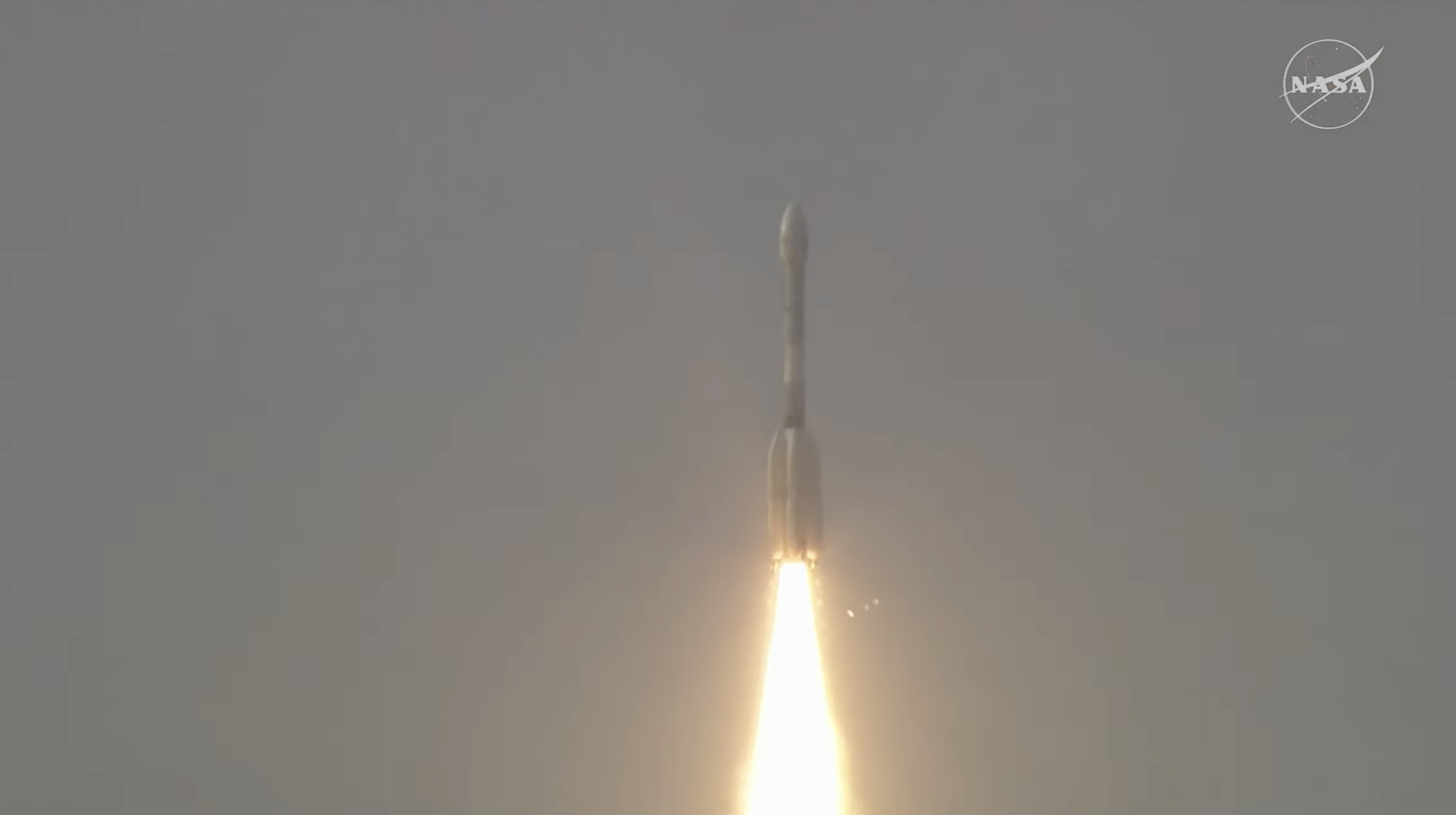
NASA-ISRO Satellite Lifts Off to Track Earth’s Changing Surfaces
Editor’s Note: This release was edited on July 30, 2025, to correct the mission launch time in the IST time zone.
Carrying an advanced radar system that will produce a dynamic, three-dimensional view of Earth in unprecedented detail, the NISAR (NASA-ISRO Synthetic Aperture Radar) satellite has launched from Satish Dhawan Space Centre in Sriharikota, Andhra Pradesh, India.
Jointly developed by NASA and the Indian Space Research Organisation (ISRO), and a critical part of the United States – India civil-space cooperation highlighted by President Trump and Prime Minister Modi earlier this year, the satellite can detect the movement of land and ice surfaces down to the centimeter. The mission will help protect communities by providing unique, actionable information to decision-makers in a diverse range of areas, including disaster response, infrastructure monitoring, and agricultural management.
The satellite lifted off aboard an ISRO Geosynchronous Satellite Launch Vehicle (GSLV) rocket at 5:40 p.m. IST (8:10 a.m. EDT), Wednesday. The ISRO ground controllers began communicating with NISAR about 20 minutes after launch, at just after 8:29 a.m. EDT, and confirmed it is operating as expected.
“Congratulations to the entire NISAR mission team on a successful launch that spanned across multiple time zones and continents in the first-ever partnership between NASA and ISRO on a mission of this sheer magnitude,” said Nicky Fox, associate administrator, Science Mission Directorate at NASA Headquarters in Washington. “Where moments are most critical, NISAR’s data will help ensure the health and safety of those impacted on Earth, as well as the infrastructure that supports them, for the benefit of all.”
From 464 miles (747 kilometers) above Earth, NISAR will use two advanced radar instruments to track changes in Earth’s forests and wetland ecosystems, monitor deformation and motion of the planet’s frozen surfaces, and detect the movement of Earth’s crust down to fractions of an inch — a key measurement in understanding how the land surface moves before, during, and after earthquakes, volcanic eruptions, and landslides.
“ISRO’s GSLV has precisely injected NISAR satellite into the intended orbit, 747 kilometers. I am happy to inform that this is GSLV’s first mission to Sun-synchronous polar orbit. With this successful launch, we are at the threshold of fulfilling the immense scientific potential NASA and ISRO envisioned for the NISAR mission more than 10 years ago,” said ISRO Chairman V Narayanan. “The powerful capability of this radar mission will help us study Earth’s dynamic land and ice surfaces in greater detail than ever before.”
The mission’s two radars will monitor nearly all the planet’s land- and ice-covered surfaces twice every 12 days, including areas of the polar Southern Hemisphere rarely covered by other Earth-observing radar satellites. The data NISAR collects also can help researchers assess how forests, wetlands, agricultural areas, and permafrost change over time.
“Observations from NISAR will provide new knowledge and tangible benefits for communities both in the U.S. and around the world,” said Karen St. Germain, director, Earth Science division at NASA Headquarters. “This launch marks the beginning of a new way of seeing the surface of our planet so that we can understand and foresee natural disasters and other changes in our Earth system that affect lives and property.”
The NISAR satellite is the first free-flying space mission to feature two radar instruments — an L-band system and an S-band system. Each system is sensitive to features of different sizes and specializes in detecting certain attributes. The L-band radar excels at measuring soil moisture, forest biomass, and motion of land and ice surfaces, while S-band radar excels at monitoring agriculture, grassland ecosystems, and infrastructure movement.
Together, the radar instruments will enhance all of the satellite’s observations, making NISAR more capable than previous synthetic aperture radar missions. Unlike optical sensors, NISAR will be able to “see” through clouds, making it possible to monitor the surface during storms, as well as in darkness and light.
NASA’s Jet Propulsion Laboratory in Southern California provided the L-band radar, and ISRO’s Space Applications Centre in Ahmedabad developed the S-band radar. The NISAR mission marks the first time the two agencies have co-developed hardware for an Earth-observing mission.
“We’re proud of the international team behind this remarkable satellite. The mission’s measurements will be global but its applications deeply local, as people everywhere will use its data to plan for a resilient future,” said Dave Gallagher, director, NASA JPL, which manages the U.S. portion of the mission for NASA. “At its core is synthetic aperture radar, a technology pioneered at NASA JPL that enables us to study Earth night and day, through all kinds of weather.”
Including L-band and S-band radars on one satellite is an evolution in SAR airborne and space-based missions that, for NASA, started in 1978 with the launch of Seasat. In 2012, ISRO began launching SAR missions starting with Radar Imaging Satellite (RISAT-1), followed by RISAT-1A in 2022, to support a wide range of applications in India.
In the coming weeks, the spacecraft will begin a roughly 90-day commissioning phase during which it will deploy its 39-foot (12-meter) radar antenna reflector. This reflector will direct and receive microwave signals from the two radars. By interpreting the differences between the two, researchers can discern characteristics about the surface below. As NISAR passes over the same locations twice every 12 days, scientists can evaluate how those characteristics have changed over time to reveal new insights about Earth’s dynamic surfaces.
The NISAR mission is an equal collaboration between NASA and ISRO. Managed for the agency by Caltech, NASA JPL leads the U.S. component of the project and is providing the mission’s L-band SAR. NASA also is providing the radar reflector antenna, the deployable boom, a high-rate communication subsystem for science data, GPS receivers, a solid-state recorder, and payload data subsystem.
Space Applications Centre Ahmedabad, ISRO’s lead center for payload development, is providing the mission’s S-band SAR instrument and is responsible for its calibration, data processing, and development of science algorithms to address the scientific goals of the mission. U R Rao Satellite Centre in Bengaluru, which leads the ISRO components of the mission, is providing the spacecraft bus. The launch vehicle is from ISRO’s Vikram Sarabhai Space Centre, launch services are through ISRO’s Satish Dhawan Space Centre, and satellite operations are by ISRO Telemetry Tracking and Command Network. National Remote Sensing Centre in Hyderabad is responsible for S-band data reception, operational products generation, and dissemination.
To learn more about NISAR, visit:
-end-
Karen Fox / Elizabeth Vlock
Headquarters, Washington
202-358-1600
karen.c.fox@nasa.gov / elizabeth.a.vlock@nasa.gov
Andrew Wang / Jane J. Lee
Jet Propulsion Laboratory, Pasadena, Calif.
626-379-6874 / 818-354-0307
andrew.wang@jpl.nasa.gov / jane.j.lee@jpl.nasa.gov
Webb traces details of complex planetary nebula
More than one star contributes to the irregular shape of NGC 6072 – Webb’s newest look at this planetary nebula in the near- and mid-infrared shows what may appear as a very messy scene resembling splattered paint. However, the unusual, asymmetrical scene hints at more complicated mechanisms underway, as the star central to the scene approaches the very final stages of its life and expels shells of material, losing up to 80 percent of its mass.
Powerful NISAR Earth-observing satellite loaded up for launch in India | Space photo of the day for July 30, 2025
NASA’s Webb Traces Details of Complex Planetary Nebula
- Webb
- News
- Overview
- Science
- Observatory
- Multimedia
- Team
- More
NASA, ESA, CSA, STScI
Since their discovery in the late 1700s, astronomers have learned that planetary nebulae, or the expanding shell of glowing gas expelled by a low-intermediate mass star late in its life, can come in all shapes and sizes. Most planetary nebula present as circular, elliptical, or bi-polar, but some stray from the norm, as seen in new high-resolution images of planetary nebulae by NASA’s James Webb Space Telescope.
Webb’s newest look at planetary nebula NGC 6072 in the near- and mid-infrared shows what may appear as a very messy scene resembling splattered paint. However, the unusual, asymmetrical appearance hints at more complicated mechanisms underway, as the star central to the scene approaches the very final stages of its life and expels shells of material, losing up to 80 percent of its mass. Astronomers are using Webb to study planetary nebulae to learn more about the full life cycle of stars and how they impact their surrounding environments.
Image A: NGC 6072 (NIRCam Image) NASA’s James Webb Space Telescope’s view of planetary nebula NGC 6072 in the near-infrared shows a complex scene of multiple outflows expanding out at different angles from a dying star at the center of the scene. In this image, the red areas represent cool molecular gas, for example, molecular hydrogen. NASA, ESA, CSA, STScI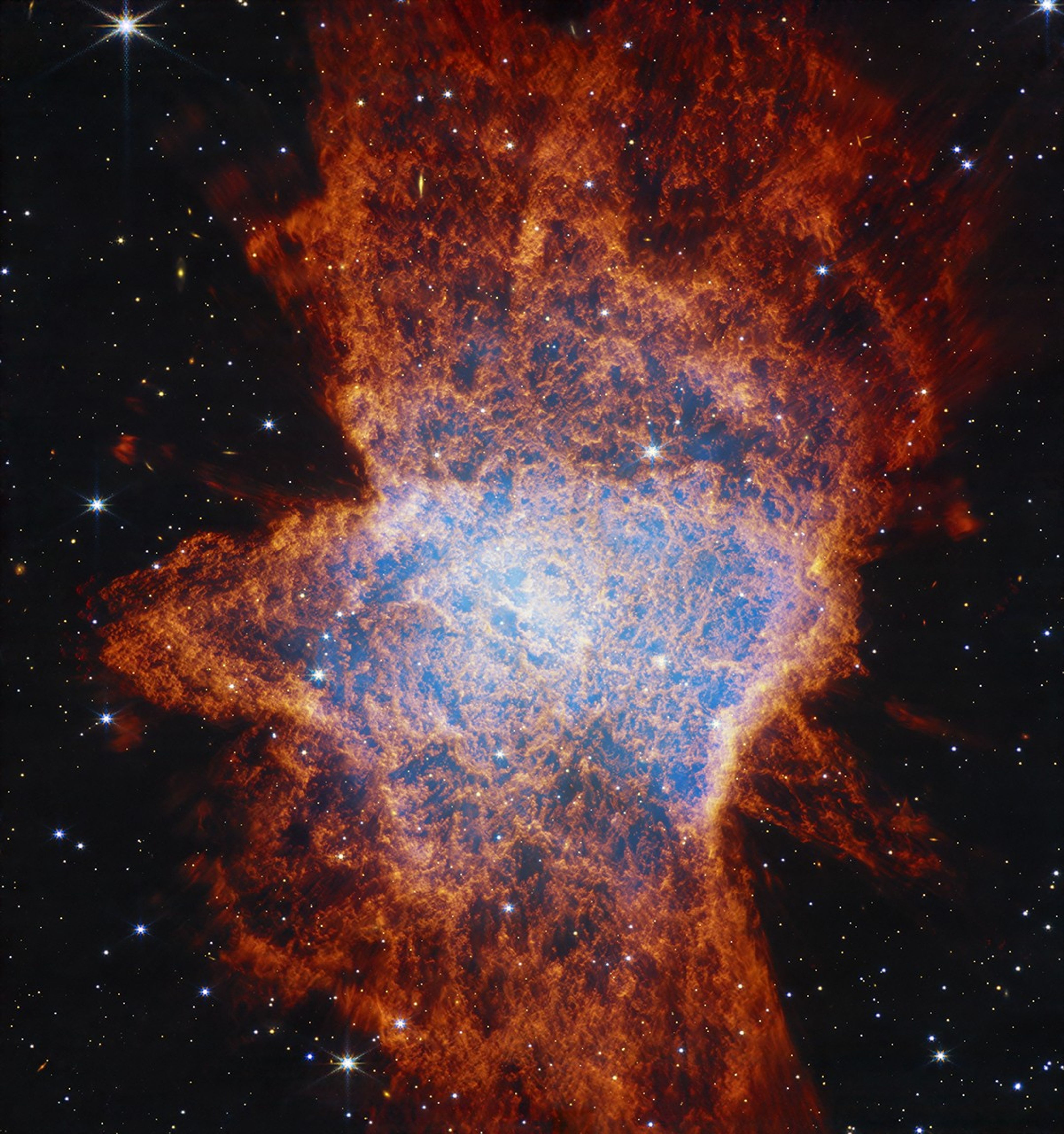
First, taking a look at the image from Webb’s NIRCam (Near-Infrared Camera), it’s readily apparent that this nebula is multi-polar. This means there are several different elliptical outflows jetting out either way from the center, one from 11 o’clock to 5 o’clock, another from 1 o’clock to 7 o’clock, and possibly a third from 12 o’clock to 6 o’clock. The outflows may compress material as they go, resulting in a disk seen perpendicular to it.
Astronomers say this is evidence that there are likely at least two stars at the center of this scene. Specifically, a companion star is interacting with an aging star that had already begun to shed some of its outer layers of gas and dust.
The central region of the planetary nebula glows from the hot stellar core, seen as a light blue hue in near-infrared light. The dark orange material, which is made up of gas and dust, follows pockets or open areas that appear dark blue. This clumpiness could be created when dense molecular clouds formed while being shielded from hot radiation from the central star. There could also be a time element at play. Over thousands of years, inner fast winds could be ploughing through the halo cast off from the main star when it first started to lose mass.
Image B: NGC 6072 (MIRI Image) The mid-infrared view of planetary nebula NGC 6072 from NASA’s James Webb Space Telescope show expanding circular shells around the outflows from the dying central star. In this image, the blue represents cool molecular gas seen in red in the image from Webb’s NIRCam (Near-Infrared Camera) due to color mapping. NASA, ESA, CSA, STScI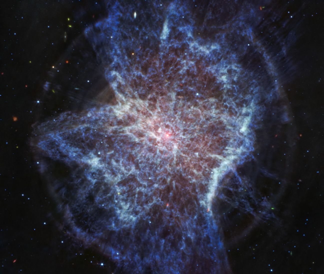
The longer wavelengths captured by Webb’s MIRI (Mid-Infrared Instrument) are highlighting dust, revealing the star researchers suspect could be central to this scene. It appears as a small pinkish-whitish dot in this image.
Webb’s look in the mid-infrared wavelengths also reveals concentric rings expanding from the central region, the most obvious circling just past the edges of the lobes.
This may be additional evidence of a secondary star at the center of the scene hidden from our view. The secondary star, as it circles repeatedly around the original star, could have carved out rings of material in a bullseye pattern as the main star was expelling mass during an earlier stage of its life.
The rings may also hint at some kind of pulsation that resulted in gas or dust being expelled uniformly in all directions separated by say, thousands of years.
The red areas in NIRCam and blue areas in MIRI both trace cool molecular gas (likely molecular hydrogen) while central regions trace hot ionized gas.
As the star at the center of a planetary nebula cools and fades, the nebula will gradually dissipate into the interstellar medium — contributing enriched material that helps form new stars and planetary systems, now containing those heavier elements.
Webb’s imaging of NGC 6072 opens the door to studying how the planetary nebulae with more complex shapes contribute to this process.
The James Webb Space Telescope is the world’s premier space science observatory. Webb is solving mysteries in our solar system, looking beyond to distant worlds around other stars, and probing the mysterious structures and origins of our universe and our place in it. Webb is an international program led by NASA with its partners, ESA (European Space Agency) and CSA (Canadian Space Agency).
To learn more about Webb, visit:
DownloadsView/Download all image products at all resolutions for this article from the Space Telescope Science Institute.
Media ContactsLaura Betz – laura.e.betz@nasa.gov
NASA’s Goddard Space Flight Center, Greenbelt, Md.
Hannah Braun – hbraun@stsci.edu
Space Telescope Science Institute, Baltimore, Md.
View more Webb planetary nebula images
Learn more about planetary nebula
Interactive: Explore the Helix Nebula planetary nebula
Watch ViewSpace videos about planetary nebulas
Related For Kids En Español Keep Exploring Related Topics James Webb Space TelescopeWebb is the premier observatory of the next decade, serving thousands of astronomers worldwide. It studies every phase in the…
Stars
Stars Stories
Universe
Share Details Last Updated Jul 30, 2025 Editor Marty McCoy Contact Laura Betz laura.e.betz@nasa.gov Related Terms
NASA’s Webb Traces Details of Complex Planetary Nebula
- Webb
- News
- Overview
- Science
- Observatory
- Multimedia
- Team
- More
NASA, ESA, CSA, STScI
Since their discovery in the late 1700s, astronomers have learned that planetary nebulae, or the expanding shell of glowing gas expelled by a low-intermediate mass star late in its life, can come in all shapes and sizes. Most planetary nebula present as circular, elliptical, or bi-polar, but some stray from the norm, as seen in new high-resolution images of planetary nebulae by NASA’s James Webb Space Telescope.
Webb’s newest look at planetary nebula NGC 6072 in the near- and mid-infrared shows what may appear as a very messy scene resembling splattered paint. However, the unusual, asymmetrical appearance hints at more complicated mechanisms underway, as the star central to the scene approaches the very final stages of its life and expels shells of material, losing up to 80 percent of its mass. Astronomers are using Webb to study planetary nebulae to learn more about the full life cycle of stars and how they impact their surrounding environments.
Image A: NGC 6072 (NIRCam Image) NASA’s James Webb Space Telescope’s view of planetary nebula NGC 6072 in the near-infrared shows a complex scene of multiple outflows expanding out at different angles from a dying star at the center of the scene. In this image, the red areas represent cool molecular gas, for example, molecular hydrogen. NASA, ESA, CSA, STScIFirst, taking a look at the image from Webb’s NIRCam (Near-Infrared Camera), it’s readily apparent that this nebula is multi-polar. This means there are several different elliptical outflows jetting out either way from the center, one from 11 o’clock to 5 o’clock, another from 1 o’clock to 7 o’clock, and possibly a third from 12 o’clock to 6 o’clock. The outflows may compress material as they go, resulting in a disk seen perpendicular to it.
Astronomers say this is evidence that there are likely at least two stars at the center of this scene. Specifically, a companion star is interacting with an aging star that had already begun to shed some of its outer layers of gas and dust.
The central region of the planetary nebula glows from the hot stellar core, seen as a light blue hue in near-infrared light. The dark orange material, which is made up of gas and dust, follows pockets or open areas that appear dark blue. This clumpiness could be created when dense molecular clouds formed while being shielded from hot radiation from the central star. There could also be a time element at play. Over thousands of years, inner fast winds could be ploughing through the halo cast off from the main star when it first started to lose mass.
Image B: NGC 6072 (MIRI Image) The mid-infrared view of planetary nebula NGC 6072 from NASA’s James Webb Space Telescope show expanding circular shells around the outflows from the dying central star. In this image, the blue represents cool molecular gas seen in red in the image from Webb’s NIRCam (Near-Infrared Camera) due to color mapping. NASA, ESA, CSA, STScIThe longer wavelengths captured by Webb’s MIRI (Mid-Infrared Instrument) are highlighting dust, revealing the star researchers suspect could be central to this scene. It appears as a small pinkish-whitish dot in this image.
Webb’s look in the mid-infrared wavelengths also reveals concentric rings expanding from the central region, the most obvious circling just past the edges of the lobes.
This may be additional evidence of a secondary star at the center of the scene hidden from our view. The secondary star, as it circles repeatedly around the original star, could have carved out rings of material in a bullseye pattern as the main star was expelling mass during an earlier stage of its life.
The rings may also hint at some kind of pulsation that resulted in gas or dust being expelled uniformly in all directions separated by say, thousands of years.
The red areas in NIRCam and blue areas in MIRI both trace cool molecular gas (likely molecular hydrogen) while central regions trace hot ionized gas.
As the star at the center of a planetary nebula cools and fades, the nebula will gradually dissipate into the interstellar medium — contributing enriched material that helps form new stars and planetary systems, now containing those heavier elements.
Webb’s imaging of NGC 6072 opens the door to studying how the planetary nebulae with more complex shapes contribute to this process.
The James Webb Space Telescope is the world’s premier space science observatory. Webb is solving mysteries in our solar system, looking beyond to distant worlds around other stars, and probing the mysterious structures and origins of our universe and our place in it. Webb is an international program led by NASA with its partners, ESA (European Space Agency) and CSA (Canadian Space Agency).
To learn more about Webb, visit:
DownloadsView/Download all image products at all resolutions for this article from the Space Telescope Science Institute.
Media ContactsLaura Betz – laura.e.betz@nasa.gov
NASA’s Goddard Space Flight Center, Greenbelt, Md.
Hannah Braun – hbraun@stsci.edu
Space Telescope Science Institute, Baltimore, Md.
View more Webb planetary nebula images
Learn more about planetary nebula
Interactive: Explore the Helix Nebula planetary nebula
Watch ViewSpace videos about planetary nebulas
Related For Kids En Español Keep Exploring Related Topics James Webb Space TelescopeWebb is the premier observatory of the next decade, serving thousands of astronomers worldwide. It studies every phase in the…
Stars
Stars Stories
Universe
Share Details Last Updated Jul 30, 2025 Editor Marty McCoy Contact Laura Betz laura.e.betz@nasa.gov Related Terms
U.S. Nuclear Energy Policy Could Accelerate Weapons Proliferation
The White House has now fully embraced bomb-prone nuclear fuel technology. This should stop before an arms race, atomic terrorism or even nuclear war results
Hidden Greenland Lake Punches through Giant Blocks of Ice in ‘Extremely Surprising’ Event
Water usually flows downward, but something strange happened under Greenland’s ice sheet when a deluge punched through the surface to scour an area nearly twice the size of New York’s Central Park
Looking Forward to the Moon
Looking Forward to the Moon
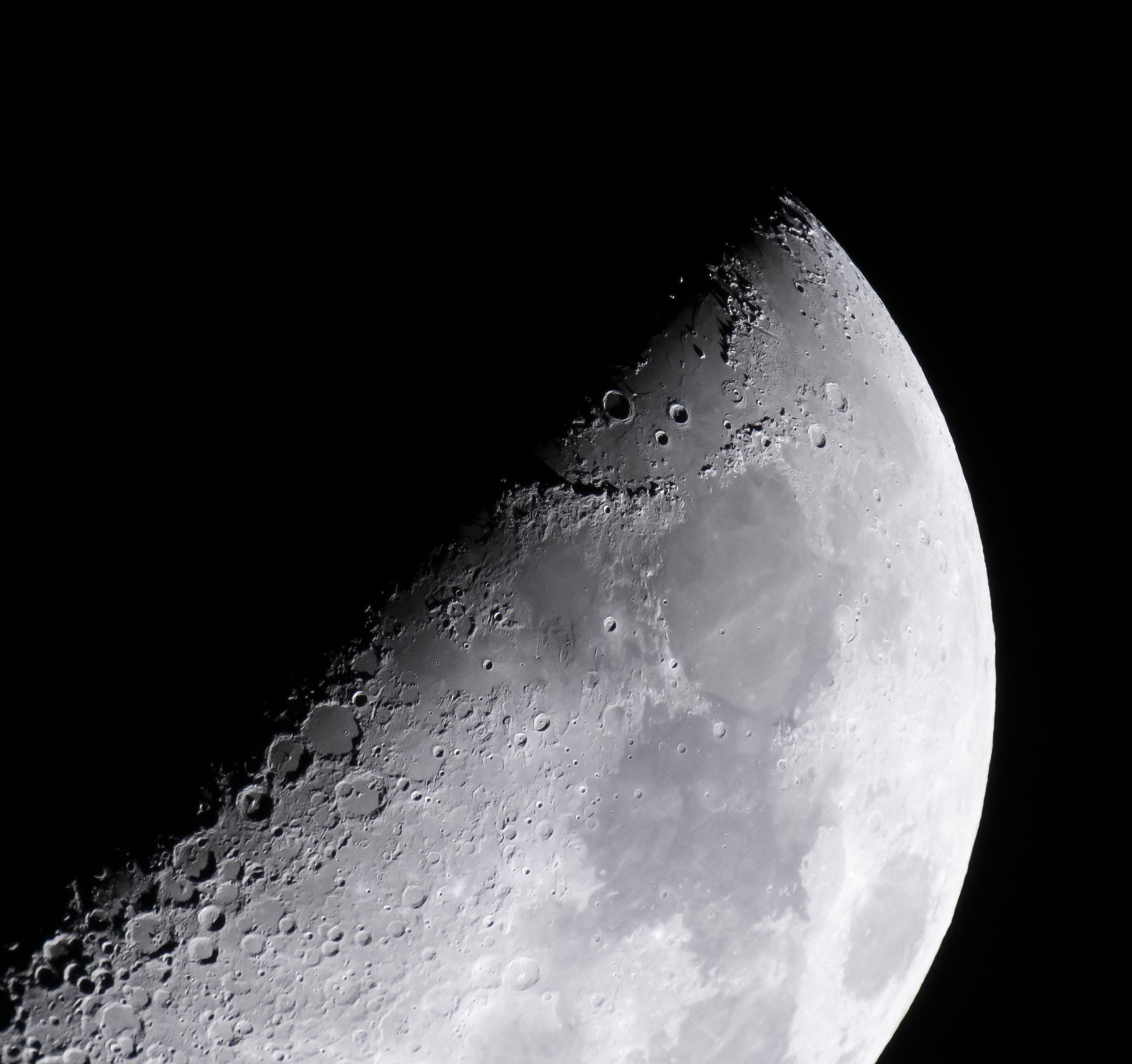
On May 8, 2022, NASA’s Exploration Ground Systems’ Program Manager Shawn Quinn captured this crop of a full frame image of the Hadley–Apennine region of Earth’s Moon including the Apollo 15 landing site (very near the edge of the shadow of one of the lunar mountains in the area). Building upon the pioneers from the Apollo Program, Artemis crews will plan to verify capabilities for humans to explore deep space and pave the way for long-term exploration and science on the lunar surface.
Read the Artemis blog for the latest mission updates.
Image credit: NASA/Shawn Quinn
Looking Forward to the Moon
On May 8, 2022, NASA’s Exploration Ground Systems’ Program Manager Shawn Quinn captured this crop of a full frame image of the Hadley–Apennine region of Earth’s Moon including the Apollo 15 landing site (very near the edge of the shadow of one of the lunar mountains in the area). Building upon the pioneers from the Apollo Program, Artemis crews will plan to verify capabilities for humans to explore deep space and pave the way for long-term exploration and science on the lunar surface.
Read the Artemis blog for the latest mission updates.
Image credit: NASA/Shawn Quinn
Ancient pots found near Pompeii contain 2500-year-old honey
Ancient pots found near Pompeii contain 2500-year-old honey
Jigsaws: SciAm Cover Art
Explore Scientific American’s most fascinating magazine covers
Science Quiz: Doing a 180
Put your science knowledge to the test with this week’s news quiz. Play now.
Neurotic Cats, One-Eyed Aliens and Hypnosis for Liars Are among the Historical Gems Reported in Scientific American
Dive into the quirkiest and most fascinating tales from Scientific American’s 180-year archive
Satellite Constellations Are Too Bright for Astronomy
The International Astronomical Union has recommended brightness limits for satellites, but companies aren't abiding by them.
The post Satellite Constellations Are Too Bright for Astronomy appeared first on Sky & Telescope.