
Feed aggregator
Ocean Temperatures Just Hit a Dire New Record
The world’s ocean absorbed more heat in 2025 than in any other year on record
Ganges Delta Under a Winter Shroud of Fog
- Earth
- Earth Observatory
- Image of the Day
- EO Explorer
- Topics
- More Content
- About
Ganges Delta Under a Winter Shroud of Fog
- Earth
- Earth Observatory
- Image of the Day
- EO Explorer
- Topics
- More Content
- About
Does Free Will Exist? Part 4: An Emergent Universe
But we’re not going for one thing or another, are we? We’re here to explore ideas – that’s most of the fun anyway. And there’s one more aspect of physics that takes part in the free will discussion, and that’s the concept of emergence.
NASA to Rush Astronauts Home after Medical Incident on ISS in Unprecedented Move
NASA on Thursday announced it would take the extraordinary step of bringing four crewmembers back to Earth from the space station before their official mission end
LIVE: Exploring the Universe
To Keep Water Liquid, the Red Planet Needed to Freeze
Mars has a curious past. Rovers have shown unequivocal evidence that liquid water existed on its surface, for probably at least 100 years. But climate models haven’t come up with how exactly that happened with what we currently understand about what the Martian climate was like back then. A new paper, published in the journal AGU Advances by Eleanor Moreland, a graduate student at Rice University, and her co-authors, has a potential explanation for what might have happened - liquid lakes on the Red Planet would have hid under small, seasonal ice sheets similar to the way they do in Antarctica on Earth.
What Happens after You Quit Weight-Loss Drugs? A New Study Offers Some Clues
A new study finds that people who quit weight-loss medications, including GLP-1 drugs, regain weight four times faster than people who stop dieting or exercising
Some Dogs Learn New Words Just Like Toddlers Do
A new study reveals that some smart dogs can learn words just by overhearing humans’ conversations
NASA to Provide Media with International Space Station Update Today
NASA will host a live news conference at 5 p.m. EST on Thursday from the agency’s headquarters in Washington to discuss the International Space Station and its crew.
On Jan. 7, the agency announced it was postponing a planned spacewalk originally scheduled for Jan. 8 while teams monitored a medical concern with a crew member currently living and working aboard the orbital laboratory.
The matter involved a single crew member, who is stable. Due to medical privacy, it is not appropriate for NASA to share more details about the crew member.
Participants in the news conference include:
- NASA Administrator Jared Isaacman
- Amit Kshatriya, associate administrator
- Dr. James Polk, chief health and medical officer, NASA Headquarters
NASA will provide live coverage of the news conference on NASA+, Amazon Prime, and the agency’s YouTube channel. Learn how to stream NASA content through a variety of online platforms, including social media.
To participate in the news conference virtually or in-person, media must RSVP for details no later than one hour before the start of the event to the NASA Newsroom at: hq-media@mail.nasa.gov. NASA’s media credentialing policy is online.
To learn more about the International Space Station, visit:
-end-
Bethany Stevens / Cheryl Warner
Headquarters, Washington
202-358-1600
bethany.c.stevens@nasa.gov / cheryl.m.warner@nasa.gov
Why a January Heat Wave Is Breaking Records across the South
An area of high pressure is bringing record-high heat to some parts of the U.S., with an added boost from climate change
Tree bark microbiome has important overlooked role in climate
Tree bark microbiome has important overlooked role in climate
Do Monkeys Make Faces on Purpose?
A new study suggests that primate facial expressions may not just be reflex
This Newly Discovered Asteroid, Almost Half a Mile Wide, Just Set a New Space Record
A giant asteroid has sent astronomers into a spin, setting a record for how fast it rotates on its axis
Supermassive Black Hole ‘Snowplows’ Can Stifle Star Formation in Spiral Galaxies
A wobbling jet from a giant, voracious black hole is suppressing star formation in a distant galaxy—and astronomers have never seen anything quite like it before
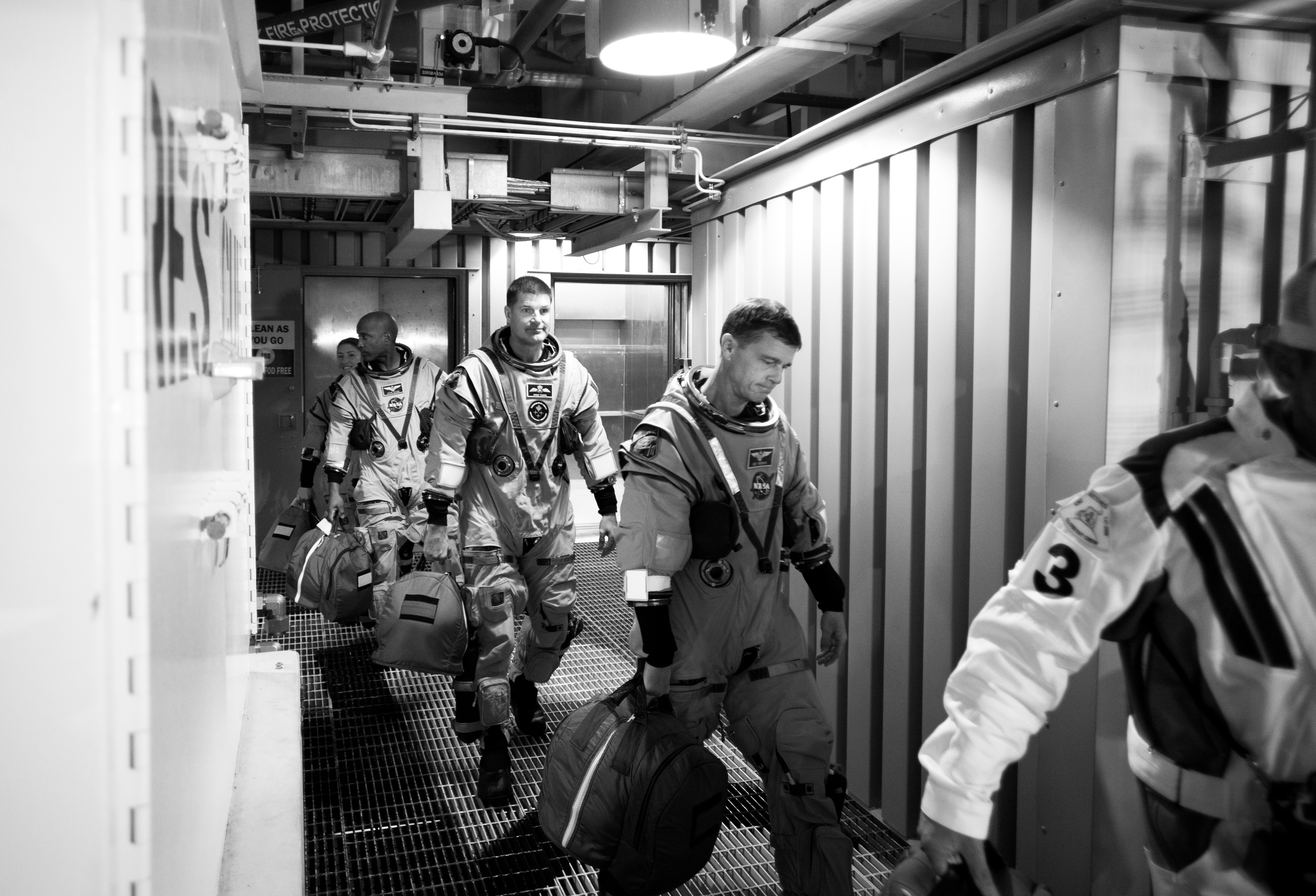
Best of 2025: Artemis II Countdown Demonstration Test
Best of 2025: Artemis II Countdown Demonstration Test
Artemis II crewmembers (left to right) NASA astronauts Christina Koch, mission specialist; and Victor Glover, pilot; CSA (Canadian Space Agency) astronaut Jeremy Hansen, mission specialist; and NASA astronaut Reid Wiseman, commander are led by Bill Owens of the Closeout Crew from the elevator at the 275-foot level of the mobile launcher to the crew access arm as they prepare to board their Orion spacecraft atop NASA’s Space Launch System rocket during the Artemis II countdown demonstration test, Saturday, Dec. 20, 2025, inside the Vehicle Assembly Building at NASA’s Kennedy Space Center in Florida. For this operation, the Artemis II crew and launch teams are simulating the launch day timeline including suit-up, walkout, and spacecraft ingress and egress.
Through the Artemis campaign, NASA will send astronauts to explore the Moon for scientific discovery, economic benefits, and to build the foundation for the first crewed missions to Mars, for the benefit of all.
This image was chosen by NASA’s Headquarters photo team as one of the best of 2025.
Image credit: NASA/Joel Kowsky