
Feed aggregator
How Sleep Cleans the Brain and Keeps You Healthy
Washing waste from the brain is an essential function of sleep—and it could help ward off dementia
How Scientists Finally Learned That Nerves Regrow—Even in the Adult Brain
Long dismissed as impossible, nerve regrowth is offering new hope for healing injuries and treating neurodegeneration
The Universe Keeps Rewriting Cosmology
The universe has a habit of disproving “unassailable” facts
We Thought DNA Ran Our Lives until We Discovered RNA Is in Charge
DNA holds our genetic blueprints, but its cousin, RNA, conducts our daily lives
NASA Invites You to Celebrate National Aviation Day 2025
5 min read
Preparations for Next Moonwalk Simulations Underway (and Underwater) This National Aviation Day graphic shows Orville Wright surrounded by the faces of some of NASA’s aeronautical innovators.NASA / Maria Werries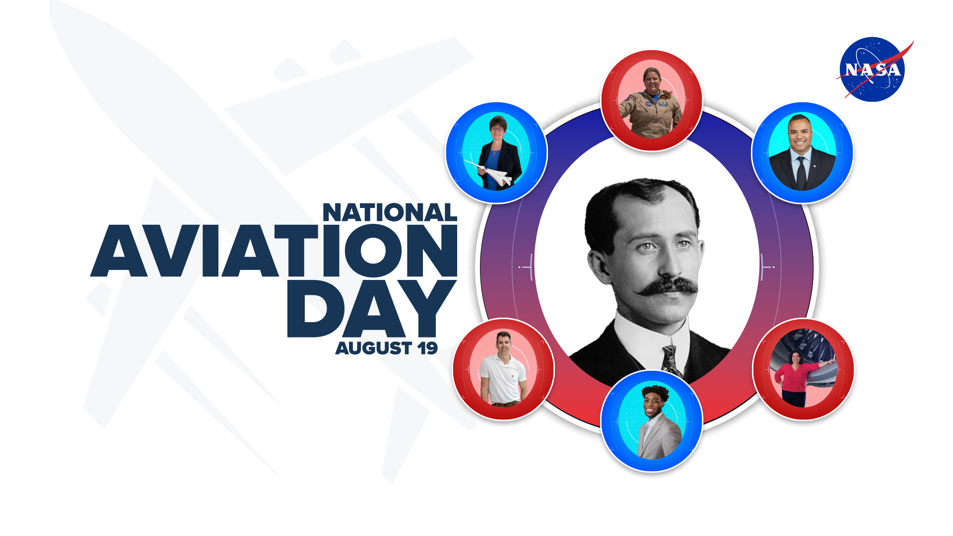
The first “A” in NASA stands for Aeronautics – so naturally that means today, Aug. 19, National Aviation Day, is one of our favorite days all year!
National Aviation Day was first proclaimed in 1939 by President Franklin Roosevelt to celebrate the birthday of aviation pioneer Orville Wright, who, with his brother Wilbur, in 1903, were the first humans to achieve powered flight.
Each year since the President first marked the occasion, sky-faring Americans have come together on this date in an annual celebration of flight – a time to revel in spreading our wings and slipping the surly bonds of Earth.
All of us at NASA share in that celebration. We love everything about flight, whether it’s into space or within Earth’s atmosphere.
Our aeronautical innovators are dedicated to improving the design of airplanes to carry on pioneering new technologies in high-speed flight, airframes and propulsion methods, aerospace engineering modelling, and automating airspace and safety management.
Our heritage in aviation research goes back more than 100 years. We’ve helped air travel become a safe, efficient, reliable form of transportation. If you’re heading to an airport, keep an eye out for these NASA-developed aviation technologies you might see on your flight:
WINGLETSNASA studies led to development of vertical extensions that can be attached to wing tips in order to reduce aerodynamic drag without having to increase wingspan. Winglets help increase an airplane’s range, decrease fuel use, and today can be seen on airplanes everywhere.NASA CHEVRON NOZZLESWorking with its industry partners, NASA researchers determined an effective way to reduce noise levels on the ground and in the passenger cabin was to add saw tooth-shaped cut outs, or chevrons, to structures such as exhaust nozzles and cowlings of jet engines.NASA / The Boeing Company GLASS COCKPITS NASA created and tested the concept of replacing dial and gauge instruments with flat panel digital displays. The displays present information more efficiently and provide the flight crew with a more easily understood picture of the aircraft’s health and position.NASA Langley / Sean Smith How Will You Celebrate?How else can you celebrate National Aviation Day? Here are seven ideas:
Visit your local science museum or NASA visitor centerExplore your local science center for exhibits about aviation and how an airplane flies. And if you live within a short drive from Norfolk, Virginia; Cleveland, or San Francisco, you might consider checking out the visitor centers associated with NASA’s Langley Research Center, Glenn Research Center, or Ames Research Center, respectively. These major NASA field centers play host to the majority of NASA’s aeronautics research. (NASA’s Armstrong Flight Research Center, the fourth of NASA’s aeronautics centers, is located within the restricted area of Edwards Air Force Base in California so they do not have a public visitor’s center.)
Watch an aviation-themed movieThere’s no shortage of classic aviation-themed movies available to watch in any format (streaming, DVD, cinema, library rentals, etc.), and with any snacks (popcorn, nachos, gummies, etc.). We dare not attempt a comprehensive list, but a good place to start is our documentary “X-59: NASA’s “Quesst” for Quiet Supersonic Flight” available to stream on NASA+.
Build an airplaneWhy not? It doesn’t have to be big enough to actually fly in – plastic model kits of the world’s most historic aircraft can be just as rewarding and just as educational, especially for kids who might be thinking about a career as an engineer or technician. In fact, many astronauts will tell you their love of aviation and space began with putting models together as a child. Another idea: Grab some LEGO bricks and build the airplane of your dreams. Or make it easy on yourself, fold a paper airplane and shoot it across the room.
Take an introductory flight lessonPilots will tell you there is a wonderful sense of freedom in flying, not to mention the incredible views and the personal sense of accomplishment. At the same time, being a pilot is not for everyone, but you won’t know unless you try! Many general aviation airports in the nation have a flight school that may offer an introductory flight lesson at a discounted price. And if you want a taste of flight without leaving the ground, computer desktop flight simulators such as Microsoft Flight Simulator or X-Plane are popular choices and can get you into the virtual sky in short order.
Visit your local library or download a NASA e-bookAviation-themed books, whether fact or fiction, are all over the shelves of your local library – literally. That’s because there’s no single Dewey Decimal number for aviation. A book about aviation history will be in a different section of the library than a book about how to design an airplane. And creative nonfiction books such as the Mark Vanhoenacker’s “Skyfaring,” or autobiographies such as Eileen Collins’ “Through the Glass Ceiling to the Stars,” are off on yet another shelf. Don’t hesitate to ask your librarian for help. And when you get back from the library, or while still there, jump online and check out the NASA e-books you can download and own for free.
Have a plane spotting picnic near an airportAt Washington’s National Airport, it’s Gravelly Point. In Tampa, Florida it’s International Mall. If you live near a major international airport, chances are you know the best place where the locals can go to watch aircraft take off and land up close. Be sure to take heed of any security restrictions about where you can and can’t go. But once you have your spot picked out, then load up your picnic basket and camp out for an evening of plane spotting. See how many different types of airplanes you can count or identify.
Follow what we’re doing to transform aviationNASA’s aeronautical innovators are working to transform air transportation to meet the future needs of the global aviation community. Sounds like a big job, right? It is and there are many ways in which NASA is doing this. Improving an airplane’s aerodynamics, making airplanes more efficient and quieter, working with the Federal Aviation Administration to improve air traffic control – the list could go on for many thousands of more words. Bookmark our NASA Aeronautics topic page and follow us on social media @NASAaero.
So remember this National Aviation Day, NASA is with you when you fly!
About the AuthorJohn GouldAeronautics Research Mission DirectorateJohn Gould is a member of NASA Aeronautics' Strategic Communications team at NASA Headquarters in Washington, DC. He is dedicated to public service and NASA’s leading role in scientific exploration. Prior to working for NASA Aeronautics, he was a spaceflight historian and writer, having a lifelong passion for space and aviation.
Facebook logo @NASA@NASAaero@NASA_es @NASA@NASAaero@NASA_es Instagram logo @NASA@NASAaero@NASA_es Linkedin logo @NASA Explore More 5 min read National Aviation Day: Celebrating NASA’s Heritage While Charting Our Future Article 12 hours ago 4 min read NASA Tests Research Aircraft to Improve Air Taxi Flight Controls Article 6 days ago 3 min read NASA Uses Wind Tunnel to Test Advanced Air Mobility Aircraft Wing Article 2 weeks ago Keep Exploring Discover More Topics From NASAMissions
Artemis
Aeronautics STEM
Explore NASA’s History
Share Details Last Updated Aug 19, 2025 Related TermsNASA Invites You to Celebrate National Aviation Day 2025
5 min read
Preparations for Next Moonwalk Simulations Underway (and Underwater) This National Aviation Day graphic shows Orville Wright surrounded by the faces of some of NASA’s aeronautical innovators.NASA / Maria WerriesThe first “A” in NASA stands for Aeronautics – so naturally that means today, Aug. 19, National Aviation Day, is one of our favorite days all year!
National Aviation Day was first proclaimed in 1939 by President Franklin Roosevelt to celebrate the birthday of aviation pioneer Orville Wright, who, with his brother Wilbur, in 1903, were the first humans to achieve powered flight.
Each year since the President first marked the occasion, sky-faring Americans have come together on this date in an annual celebration of flight – a time to revel in spreading our wings and slipping the surly bonds of Earth.
All of us at NASA share in that celebration. We love everything about flight, whether it’s into space or within Earth’s atmosphere.
Our aeronautical innovators are dedicated to improving the design of airplanes to carry on pioneering new technologies in high-speed flight, airframes and propulsion methods, aerospace engineering modelling, and automating airspace and safety management.
Our heritage in aviation research goes back more than 100 years. We’ve helped air travel become a safe, efficient, reliable form of transportation. If you’re heading to an airport, keep an eye out for these NASA-developed aviation technologies you might see on your flight:
WINGLETSNASA studies led to development of vertical extensions that can be attached to wing tips in order to reduce aerodynamic drag without having to increase wingspan. Winglets help increase an airplane’s range, decrease fuel use, and today can be seen on airplanes everywhere.NASA CHEVRON NOZZLESWorking with its industry partners, NASA researchers determined an effective way to reduce noise levels on the ground and in the passenger cabin was to add saw tooth-shaped cut outs, or chevrons, to structures such as exhaust nozzles and cowlings of jet engines.NASA / The Boeing Company GLASS COCKPITS NASA created and tested the concept of replacing dial and gauge instruments with flat panel digital displays. The displays present information more efficiently and provide the flight crew with a more easily understood picture of the aircraft’s health and position.NASA Langley / Sean Smith How Will You Celebrate?How else can you celebrate National Aviation Day? Here are seven ideas:
Visit your local science museum or NASA visitor centerExplore your local science center for exhibits about aviation and how an airplane flies. And if you live within a short drive from Norfolk, Virginia; Cleveland, or San Francisco, you might consider checking out the visitor centers associated with NASA’s Langley Research Center, Glenn Research Center, or Ames Research Center, respectively. These major NASA field centers play host to the majority of NASA’s aeronautics research. (NASA’s Armstrong Flight Research Center, the fourth of NASA’s aeronautics centers, is located within the restricted area of Edwards Air Force Base in California so they do not have a public visitor’s center.)
Watch an aviation-themed movieThere’s no shortage of classic aviation-themed movies available to watch in any format (streaming, DVD, cinema, library rentals, etc.), and with any snacks (popcorn, nachos, gummies, etc.). We dare not attempt a comprehensive list, but a good place to start is our documentary “X-59: NASA’s “Quesst” for Quiet Supersonic Flight” available to stream on NASA+.
Build an airplaneWhy not? It doesn’t have to be big enough to actually fly in – plastic model kits of the world’s most historic aircraft can be just as rewarding and just as educational, especially for kids who might be thinking about a career as an engineer or technician. In fact, many astronauts will tell you their love of aviation and space began with putting models together as a child. Another idea: Grab some LEGO bricks and build the airplane of your dreams. Or make it easy on yourself, fold a paper airplane and shoot it across the room.
Take an introductory flight lessonPilots will tell you there is a wonderful sense of freedom in flying, not to mention the incredible views and the personal sense of accomplishment. At the same time, being a pilot is not for everyone, but you won’t know unless you try! Many general aviation airports in the nation have a flight school that may offer an introductory flight lesson at a discounted price. And if you want a taste of flight without leaving the ground, computer desktop flight simulators such as Microsoft Flight Simulator or X-Plane are popular choices and can get you into the virtual sky in short order.
Visit your local library or download a NASA e-bookAviation-themed books, whether fact or fiction, are all over the shelves of your local library – literally. That’s because there’s no single Dewey Decimal number for aviation. A book about aviation history will be in a different section of the library than a book about how to design an airplane. And creative nonfiction books such as the Mark Vanhoenacker’s “Skyfaring,” or autobiographies such as Eileen Collins’ “Through the Glass Ceiling to the Stars,” are off on yet another shelf. Don’t hesitate to ask your librarian for help. And when you get back from the library, or while still there, jump online and check out the NASA e-books you can download and own for free.
Have a plane spotting picnic near an airportAt Washington’s National Airport, it’s Gravelly Point. In Tampa, Florida it’s International Mall. If you live near a major international airport, chances are you know the best place where the locals can go to watch aircraft take off and land up close. Be sure to take heed of any security restrictions about where you can and can’t go. But once you have your spot picked out, then load up your picnic basket and camp out for an evening of plane spotting. See how many different types of airplanes you can count or identify.
Follow what we’re doing to transform aviationNASA’s aeronautical innovators are working to transform air transportation to meet the future needs of the global aviation community. Sounds like a big job, right? It is and there are many ways in which NASA is doing this. Improving an airplane’s aerodynamics, making airplanes more efficient and quieter, working with the Federal Aviation Administration to improve air traffic control – the list could go on for many thousands of more words. Bookmark our NASA Aeronautics topic page and follow us on social media @NASAaero.
So remember this National Aviation Day, NASA is with you when you fly!
About the AuthorJohn GouldAeronautics Research Mission DirectorateJohn Gould is a member of NASA Aeronautics' Strategic Communications team at NASA Headquarters in Washington, DC. He is dedicated to public service and NASA’s leading role in scientific exploration. Prior to working for NASA Aeronautics, he was a spaceflight historian and writer, having a lifelong passion for space and aviation.
Facebook logo @NASA@NASAaero@NASA_es @NASA@NASAaero@NASA_es Instagram logo @NASA@NASAaero@NASA_es Linkedin logo @NASA Explore More 5 min read National Aviation Day: Celebrating NASA’s Heritage While Charting Our Future Article 2 hours ago 4 min read NASA Tests Research Aircraft to Improve Air Taxi Flight Controls Article 5 days ago 3 min read NASA Uses Wind Tunnel to Test Advanced Air Mobility Aircraft Wing Article 2 weeks ago Keep Exploring Discover More Topics From NASAMissions
Artemis
Aeronautics STEM
Explore NASA’s History
Share Details Last Updated Aug 19, 2025 Related Terms'Devil Comet' contains 'strongest evidence yet' that comets delivered water to Earth
AI-generated responses are undermining crowdsourced research studies
AI-generated responses are undermining crowdsourced research studies
How Are AI Chatbots Affecting Teen Development?
More and more kids are turning to artificial intelligence chatbots for social interaction. We are scrambling to understand the pros and cons of their use
More Teens Are Getting Vaccines
Bucking national trends in childhood vaccination rates, more teens are getting recommended shots, including for measles and whooping cough
SpaceX completes investigation into recent Starship failures, clears the way for Flight 10
Where the Wild Things Are: Wildlife Management with Johnson’s Matt Strausser
If you asked someone what they expected to see during a visit to NASA’s Johnson Space Center, they would probably list things like astronauts, engineers, and maybe a spacecraft or two. It might be a surprise to learn you can also spy hundreds of species of animals – from geckos and snakes to white-tailed deer and red-tailed hawks.
Ensuring those species and Johnson’s workforce can safely coexist is the main job of Matt Strausser, Johnson’s senior biologist for wildlife management. Strausser works to reduce the negative impacts animals can have on Johnson’s operations as well as the negative impact humans might have on native wildlife and their habitats.
NASA’s Johnson Space Center Senior Biologist Matt Strausser leads a nature hike to Johnson staff that detailed the native plant species and wildlife onsite, invasive species, and mitigation efforts.NASA/Lauren Harnett
Strausser joined NASA in 2012, fresh out of graduate school, when he was hired on a six-month contract to write Johnson’s first Wildlife Management Plan. “My contract was extended a couple of times until I became a regular part of the facilities service contract, which is where I still am today,” he said.
Strausser remembers being interested in natural resources from a young age. “I spent a lot of my childhood poring through copies of National Geographic, hiking, and camping,” he said. When it was time for college, Strausser decided to study biology and natural resource management. He spent his summers in jobs or internships that mostly involved endangered wildlife species, including Attwater’s prairie chickens, which are bred at Johnson through a partnership with the Houston Zoo. Strausser noted that he conducted research across the country while he was a student, and even studied fish for a short time in the South Pacific.
“After all of those adventures in faraway places, I find it ironic that I ended up about 20 miles from where I grew up,” he said. “Once I got onsite, it did not take me long to find that this property has great remnant native plant communities, a fascinating land use history, and some unique natural resource challenges that come from the work done here. Those factors really drew me in and helped motivate me to build a career at Johnson.”
Matthew Strausser received a Silver Snoopy Award through NASA’s Space Flight Awareness Program in 2018, in recognition of his efforts to prevent and mitigate ant-inflicted damage to critical infrastructure electrical systems. From left: NASA astronaut Reid Weissman, Strausser, Strausser’s wife Kayla, NASA Acting Associate Administrator Vanessa Wyche. NASA
Strausser’s work involves a variety of activities. First, he gathers data about Johnson’s wildlife populations and their habitats. “I use population counts, conflict records, satellite and aerial imagery, nest surveys, outside reports, and even historical data to get an understanding of what’s on the landscape and what problems we have to tackle,” he said.
With that information, Strausser works to engage project and facility managers and provide recommendations on how to prevent or reduce the impact of wildlife problems onsite. Strausser works with Johnson’s facilities maintenance group to modify buildings to keep animals on the outside, and he gets support from the Johnson veterinarian on animal health issues. He also works closely with Johnson’s pest control and groundskeeping contracts, as their work is often adjacent to wildlife management.
He supports the safety team, as well. “Our security contractors are a great resource for reporting wildlife issues as well as helping address them,” Strausser said, adding that some of Johnson’s safety groups “have been really helpful at getting the word out about how to stay safe around our wildlife” in coordination with the center’s internal communications team. His team also responds to wildlife conflict calls, which often involve capturing and relocating animals that have wandered into areas where they pose a risk to people or operations.
Additionally, Strausser runs the facilities contract’s small unmanned aircraft system, which uses drones to conduct facility inspections, support hurricane response, and survey on-site wildlife.
An on-site wildlife snapshot captured by the Johnson Space Center facilities contract’s small unmanned aircraft system. NASA
The nature of his work has instilled in Strausser an appreciation for teamwork and collaboration among colleagues with distinct experiences. Each of the projects he works on involves team members from different organizations and contracts, and most of them do not have a background in biology. “Building a wildlife and natural resource program from the ground up and bringing all of these once-disconnected and diverse professionals together to effectively address problems – that is the achievement I take the most pride in,” he said.
Strausser observed that accomplishing the goals of the agency’s Artemis campaign will require a tremendous amount of specialized support infrastructure, and that developing and running that infrastructure will require a wide variety of professionals. “It is going to require students and specialists with all different types of backgrounds, passions, and talents.”
Overall, Strausser said he has a very dynamic job. “Wildlife issues tend to be very seasonal, so throughout the year, the types of issues I am addressing change,” he said. “On top of that, there are always new projects, problems, and questions out there that keep the work fresh and challenging.” He has learned the value of being open to new challenges and learning new skills. “Being adaptable can be just as important as mastery in a specific field,” he said.
An on-site wildlife snapshot captured by the Johnson Space Center facilities contract’s small unmanned aircraft system. NASA A Texas Longhorn relaxes onsite at Johnson Space Center, with Space Center Houston in the background.NASA Deer are plentiful on the Johnson Space Center campus.NASA A hawk perches in a tree at Johnson Space Center.NASA Attwater’s prairie chickens are bred at Johnson Space Center through a partnership with the Houston Zoo.NASA Explore More 12 min read What is BioNutrients? Article 11 minutes ago 7 min read Station Nation: Meet Tess Caswell, Extravehicular Activity Flight Controller and Lead Capsule Communicator Article 20 hours ago 3 min read Human Rating and NASA-STD-3001 Article 4 days agoWhere the Wild Things Are: Wildlife Management with Johnson’s Matt Strausser
If you asked someone what they expected to see during a visit to NASA’s Johnson Space Center, they would probably list things like astronauts, engineers, and maybe a spacecraft or two. It might be a surprise to learn you can also spy hundreds of species of animals – from geckos and snakes to white-tailed deer and red-tailed hawks.
Ensuring those species and Johnson’s workforce can safely coexist is the main job of Matt Strausser, Johnson’s senior biologist for wildlife management. Strausser works to reduce the negative impacts animals can have on Johnson’s operations as well as the negative impact humans might have on native wildlife and their habitats.
NASA’s Johnson Space Center Senior Biologist Matt Strausser leads a nature hike to Johnson staff that detailed the native plant species and wildlife onsite, invasive species, and mitigation efforts.NASA/Lauren HarnettStrausser joined NASA in 2012, fresh out of graduate school, when he was hired on a six-month contract to write Johnson’s first Wildlife Management Plan. “My contract was extended a couple of times until I became a regular part of the facilities service contract, which is where I still am today,” he said.
Strausser remembers being interested in natural resources from a young age. “I spent a lot of my childhood poring through copies of National Geographic, hiking, and camping,” he said. When it was time for college, Strausser decided to study biology and natural resource management. He spent his summers in jobs or internships that mostly involved endangered wildlife species, including Attwater’s prairie chickens, which are bred at Johnson through a partnership with the Houston Zoo. Strausser noted that he conducted research across the country while he was a student, and even studied fish for a short time in the South Pacific.
“After all of those adventures in faraway places, I find it ironic that I ended up about 20 miles from where I grew up,” he said. “Once I got onsite, it did not take me long to find that this property has great remnant native plant communities, a fascinating land use history, and some unique natural resource challenges that come from the work done here. Those factors really drew me in and helped motivate me to build a career at Johnson.”
Matthew Strausser received a Silver Snoopy Award through NASA’s Space Flight Awareness Program in 2018, in recognition of his efforts to prevent and mitigate ant-inflicted damage to critical infrastructure electrical systems. From left: NASA astronaut Reid Weissman, Strausser, Strausser’s wife Kayla, NASA Acting Associate Administrator Vanessa Wyche. NASAStrausser’s work involves a variety of activities. First, he gathers data about Johnson’s wildlife populations and their habitats. “I use population counts, conflict records, satellite and aerial imagery, nest surveys, outside reports, and even historical data to get an understanding of what’s on the landscape and what problems we have to tackle,” he said.
With that information, Strausser works to engage project and facility managers and provide recommendations on how to prevent or reduce the impact of wildlife problems onsite. Strausser works with Johnson’s facilities maintenance group to modify buildings to keep animals on the outside, and he gets support from the Johnson veterinarian on animal health issues. He also works closely with Johnson’s pest control and groundskeeping contracts, as their work is often adjacent to wildlife management.
He supports the safety team, as well. “Our security contractors are a great resource for reporting wildlife issues as well as helping address them,” Strausser said, adding that some of Johnson’s safety groups “have been really helpful at getting the word out about how to stay safe around our wildlife” in coordination with the center’s internal communications team. His team also responds to wildlife conflict calls, which often involve capturing and relocating animals that have wandered into areas where they pose a risk to people or operations.
Additionally, Strausser runs the facilities contract’s small unmanned aircraft system, which uses drones to conduct facility inspections, support hurricane response, and survey on-site wildlife.
An on-site wildlife snapshot captured by the Johnson Space Center facilities contract’s small unmanned aircraft system. NASAThe nature of his work has instilled in Strausser an appreciation for teamwork and collaboration among colleagues with distinct experiences. Each of the projects he works on involves team members from different organizations and contracts, and most of them do not have a background in biology. “Building a wildlife and natural resource program from the ground up and bringing all of these once-disconnected and diverse professionals together to effectively address problems – that is the achievement I take the most pride in,” he said.
Strausser observed that accomplishing the goals of the agency’s Artemis campaign will require a tremendous amount of specialized support infrastructure, and that developing and running that infrastructure will require a wide variety of professionals. “It is going to require students and specialists with all different types of backgrounds, passions, and talents.”
Overall, Strausser said he has a very dynamic job. “Wildlife issues tend to be very seasonal, so throughout the year, the types of issues I am addressing change,” he said. “On top of that, there are always new projects, problems, and questions out there that keep the work fresh and challenging.” He has learned the value of being open to new challenges and learning new skills. “Being adaptable can be just as important as mastery in a specific field,” he said.
An on-site wildlife snapshot captured by the Johnson Space Center facilities contract’s small unmanned aircraft system. NASA A Texas Longhorn relaxes onsite at Johnson Space Center, with Space Center Houston in the background.NASA Deer are plentiful on the Johnson Space Center campus.NASA A hawk perches in a tree at Johnson Space Center.NASA Attwater’s prairie chickens are bred at Johnson Space Center through a partnership with the Houston Zoo.NASA Explore More 12 min read What is BioNutrients? Article 25 minutes ago 7 min read Station Nation: Meet Tess Caswell, Extravehicular Activity Flight Controller and Lead Capsule Communicator Article 20 hours ago 3 min read Human Rating and NASA-STD-3001 Article 4 days ago1st Portuguese spaceport could soon emerge as nation grants license for launch center in the Azores (photos)
NASA Sets Coverage for SpaceX 33rd Station Resupply Launch, Arrival
NASA and SpaceX are targeting 2:45 a.m. EDT, Sunday, Aug. 24, for the next launch to deliver science investigations, supplies, and equipment to the International Space Station. This is the 33rd SpaceX commercial resupply services mission to the orbital laboratory for NASA.
Filled with more than 5,000 pounds of supplies, a SpaceX Dragon spacecraft on a Falcon 9 rocket will lift off from Space Launch Complex 40 at Cape Canaveral Space Force Station in Florida. Dragon will dock autonomously about 7:30 a.m. on Monday, Aug. 25, to the forward port of the space station’s Harmony module.
Watch agency launch and arrival coverage on NASA+, Netflix, Amazon Prime, and more. Learn how to watch NASA content through a variety of platforms, including social media.
In addition to food, supplies, and equipment for the crew, Dragon will deliver several experiments, including bone-forming stem cells for studying bone loss prevention and materials to 3D print medical implants that could advance treatments for nerve damage on Earth. Dragon also will deliver bioprinted liver tissue to study blood vessel development in microgravity and supplies to 3D print metal cubes in space. Research conducted aboard the space station advances future space exploration – including Artemis missions to the Moon and astronaut missions Mars – and provides multiple benefits to humanity.
In addition, Dragon will perform a reboost demonstration of station to maintain its current altitude. The hardware, located in the trunk of Dragon, contains an independent propellant system separate from the spacecraft to fuel two Draco engines using existing hardware and propellant system design. The boost kit will demonstrate the capability to help sustain the orbiting lab’s altitude starting in September with a series of burns planned periodically throughout the fall of 2025. During NASA’s SpaceX 31st commercial resupply services mission, the Dragon spacecraft performed its first demonstration of these capabilities on Nov. 8, 2024.
The Dragon spacecraft is scheduled to remain at the space station until December when it will depart and return to Earth with research and cargo, splashing down in the Pacific Ocean off the coast of California.
NASA’s mission coverage is as follows (all times Eastern and subject to change based on real-time operations):
Tuesday, Aug. 19:
1 p.m. – International Space Station National Laboratory Science Webinar with the following participants:
- Heidi Parris, associate program scientist, NASA’s International Space Station Program Research Office
- Michael Roberts, chief scientific officer, International Space Station National Laboratory
- James Yoo, assistant director, Wake Forest Institute of Regenerative Medicine
- Tony James, chief architect for science and space, Red Hat
- Abba Zubair, medical director and scientist, Mayo Clinic
- Arun Sharma, director, Center for Space Medicine Research, Cedars-Sinai Medical Center
Media who wish to participate must register for Zoom access no later than one hour before the start of the webinar.
The conference will stream live on the International Space Station National Lab’s website.
Friday, Aug. 22:
11:30 a.m. – Prelaunch media teleconference with the following participants:
- Bill Spetch, operations integration manager, NASA’s International Space Station Program
- Heidi Parris, associate program scientist, NASA’s International Space Station Program Research Office
- Sarah Walker, director, Dragon Mission Management, SpaceX
Media who wish to participate by phone must request dial-in information by 10 a.m. Aug. 22, by emailing NASA Kennedy Space Center’s newsroom at: ksc-newsroom@mail.nasa.gov.
Audio of the media teleconference will stream live on the agency’s YouTube channel.
Sunday, Aug. 24:
2:25 a.m. – Launch coverage begins on NASA+, Netflix, and Amazon Prime.
2:45 a.m. – Launch
Monday, Aug. 25:
6 a.m. – Arrival coverage begins on NASA+, Netflix, and Amazon Prime.
7:30 a.m. – Docking
NASA website launch coverage
Launch day coverage of the mission will be available on the NASA website. Coverage will include live streaming and blog updates beginning no earlier than 2:25 a.m. Sunday, Aug. 24, as the countdown milestones occur. On-demand streaming video on NASA+ and photos of the launch will be available shortly after liftoff. For questions about countdown coverage, contact the NASA Kennedy newsroom at 321-867-2468. Follow countdown coverage on our International Space Station blog for updates.
Attend Launch Virtually
Members of the public can register to attend this launch virtually. NASA’s virtual guest program for this mission also includes curated launch resources, notifications about related opportunities or changes, and a stamp for the NASA virtual guest passport following launch.
Watch, Engage on Social Media Let people know you’re watching the mission on X, Facebook, and Instagram by following and tagging these accounts:
X: @NASA, @NASAKennedy, @NASASocial, @Space_Station, @ISS_CASIS
Facebook: NASA, NASAKennedy, ISS, ISS National Lab
Instagram: @NASA, @NASAKennedy, @ISS, @ISSNationalLab
Coverage en Espanol
Did you know NASA has a Spanish section called NASA en Espanol? Check out NASA en Espanol on X, Instagram, Facebook, and YouTube for additional mission coverage.
Para obtener información sobre cobertura en español en el Centro Espacial Kennedy o si desea solicitar entrevistas en español, comuníquese con Antonia Jaramillo o Messod Bendayan a: antonia.jaramillobotero@nasa.gov o messod.c.bendayan@nasa.gov.
Learn more about the mission at:
https://www.nasa.gov/mission/nasas-spacex-crs-33/
-end-
Joshua Finch
Headquarters, Washington
202-358-1100
joshua.a.finch@nasa.gov
Steven Siceloff
Kennedy Space Center, Fla.
321-876-2468
steven.p.siceloff@nasa.gov
Sandra Jones / Joseph Zakrzewski
Johnson Space Center, Houston
281-483-5111
sandra.p.jones@nasa.gov / joseph.a.zakrzewskI@nasa.gov