
Feed aggregator
Lake Shorelines on Titan are Shaped by Methane Waves
Distant Titan is an oddball in the Solar System. Saturn’s largest moon—and the second largest in the entire Solar System—has an atmosphere denser than Earth’s. It also has stable lakes and seas of liquid hydrocarbons on its surface.
New research shows that waves on these seas are eroding Titan’s coastlines.
The research is “Signatures of Wave Erosion in Titan’s Coasts,” and it’s published in Science Advances. The lead author is Rose Palermo, an MIT graduate and research geologist at the U.S. Geological Survey.
In 2007, the Cassini spacecraft spotted lakes and seas of liquid hydrocarbons, mostly methane and ethane, on Saturn’s moon Titan. Titan and Earth are the only two bodies in the Solar System known to have surface liquids. Scientists have only Cassini data from Titan to work with, and they’ve been poring over the data in an effort to understand this strange world.
The moon’s seas are one of the most intriguing features throughout the entire Solar System. But they’re difficult to observe because of the thick atmosphere. Researchers have wondered if waves shape the coastlines, but there are conflicting signs about the nature of the seas. They could be rough, or they could be smooth. A paper from 2014 suggested that transient features in Titan’s northern sea, Ligeia Mare, could be waves.
But there’s no certainty.
“We found that if the coastlines have eroded, their shapes are more consistent with erosion by waves than by uniform erosion or no erosion at all.”
Rose Palermo, lead author, U.S. Geological Survey“Some people who tried to see evidence for waves didn’t see any, and said, ‘These seas are mirror-smooth,'” lead author Palermo said in a press release accompanying the research. “Others said they did see some roughness on the liquid surface but weren’t sure if waves caused it.”
It seems likely that there would be waves on Titan. To investigate this question, researchers at MIT compared Titan’s shorelines to shorelines on Earth to see if they match.
The seas and lakes on Titan look much like some on Earth. They appear to be flooded valleys and depressions. But scientists are uncertain if these bodies of water are eroding their coastlines like those on Earth. “Spacecraft observations and theoretical models suggest that wind may cause waves to form on Titan’s seas, potentially driving coastal erosion, but the observational evidence of waves is indirect, and the processes affecting shoreline evolution on Titan remain unknown,” the authors write in their paper.
The problem is that there’s no reliable way to connect shoreline morphology directly to the mechanisms that shape it, even on Earth. To try to understand how erosion affects Titan’s coastlines, the researchers started with Earth. They examined how different coastal erosion mechanisms shape Earth’s coastlines, then applied the framework to Titan.
There are basically two types of coastal erosion: wave-driven erosion and uniform erosion. Each type produces different coastlines.
Wave erosion is driven by wind and produces a change proportional to the strength of the waves. Waves are usually stronger the farther they travel before they hit a coast. Wave erosion creates long, smooth stretches of coast where the coast is fully exposed and bays in protected areas where less erosion occurs. The distance the wind can blow to generate waves on a particular water body before striking a coast is called ‘fetch.’
“Wave erosion is driven by the height and angle of the wave,” Palermo explained. “We used fetch to approximate wave height because the bigger the fetch, the longer the distance over which wind can blow and waves can grow.”
Uniform erosion is different. It doesn’t rely on mechanical wave action. The compositional differences between Earth and Titan are apparent when it comes to uniform erosion. “Titan’s crust consists mainly of water ice, but its surface solids may also include heavy hydrocarbon molecules, such as benzene, that are soluble in liquid methane and ethane, such that the liquid lakes and seas may slowly dissolve the solid coasts of the north polar terrain,” the authors explain in their research.
Over a long enough period of time, uniform erosion occurs at the same rate in all locations, producing distinct morphological features: shorelines that are generally smooth even inside bays with sharp headlands that punctuate them.
“Here, we test the hypothesis that coastal erosion has shaped Titan’s seas by investigating whether coastline shapes are most consistent with wave-driven erosion, uniform erosion, or no coastal erosion,” the authors write.
This figure from the research illustrates how the two types of erosion would shape shorelines. The images are based on simulated Titan landforms and shorelines. A shows the initial condition of Titan’s water bodies, where rivers carved out channels, and rising seas flooded them. B shows the morphology that wave erosion would produce, where the erosion rate depends on fetch. C shows the morphology that Uniform erosion would produce, where the erosion is uniform in all locations. Darker blue indicates deeper water and lighter yellow indicates higher land. Image Credit: Palermo et al. 2024.The different morphological features produced by wave-driven erosion and uniform erosion are obvious. Wave-driven erosion tends to smooth exposed sections of the coastline where fetch is large and preserve the coastline where fetch is small inside embayments.
Uniform erosion is different. It widens embayments and smooths out small-scale roughness on the coastline regardless of fetch. Headlands are the exception, which sharpen into thick-necked points that stick out into the main basin.
“We had the same starting shorelines, and we saw that you get a really different final shape under uniform erosion versus wave erosion,” said co-author Taylor Perron, Professor of Earth, Atmospheric and Planetary Sciences at MIT. “They all kind of look like the Flying Spaghetti Monster because of the flooded river valleys, but the two types of erosion produce very different endpoints.”
Titan’s Ligeia Mare is the second largest liquid body on Titan. The researchers say that its coastline appears to be altered by wave-driven erosion. Image Credit: By NASA/JPL-Caltech/ASI/Cornell – http://photojournal.jpl.nasa.gov/catalog/PIA17031, Public Domain, https://commons.wikimedia.org/w/index.php?curid=26294960“We found that if the coastlines have eroded, their shapes are more consistent with erosion by waves than by uniform erosion or no erosion at all,” Perron said.
But these are just simulations, and they have to be tested rigorously. The team’s next step was to quantify these differences in the real world. The researchers explain that they “developed a technique focusing on local relationships between shoreline roughness and fetch area” to understand and quantify the differences. Specifically, they quantified what they call “roughness” to differentiate wave-driven erosion from uniform erosion. “Simply put, a lower roughness means a smoother stretch of shoreline compared to the rest of the lake, and a higher roughness means a comparatively rough stretch of shoreline,” they write.
This figure from the research shows roughness and fetch area for two of Titan’s seas: Kraken Mare and Ligeia Mare. C and D show roughness for each sea. E and F show the normalized fetch area, assuming waves are fetch-limited. Fetch-limited means waves continue to grow as long as the fetch length increases. G and H show normalized fetch area assuming a saturation fetch length of 20 km. That means that waves only grow up to a certain fetch length and then saturate. In that case, the system is saturation-limited, and the “fetch length in all directions is truncated to a maximum value.” Image Credit: Palermo et al. 2024.The researchers say that “… shoreline roughness and normalized fetch area can be used to fingerprint wave-driven and uniform erosion and distinguish them from a coastline consisting only of flooded river valleys,” as shown in the first image.
So, what does this all boil down to?
“Our results suggest that the coastlines of Titan’s largest liquid bodies are most consistent with shorelines that have been modified by wave erosion and river incision,” the researchers write in their paper. They analyzed four coastlines and found a less than 5% probability of uniform erosion in a saturation-limited scenario and a less than 20% probability of uniform erosion in a fetch-limited scenario. That leaves wind-driven erosion as the most likely cause of erosion, which seems to confirm that Titan’s lakes and seas experience waves. “Therefore, our results suggest that the largest seas and lakes are not consistent with erosion by uniform processes (i.e., dissolution), as previously hypothesized for some of Titan’s landscapes,” they conclude.
That’s the scientific way of presenting their results, and their paper is like part of a long conversation with other scientists. In the press release, they state their conclusion more plainly for the rest of us.
“We can say, based on our results, that if the coastlines of Titan’s seas have eroded, waves are the most likely culprit,” said Perron, Professor of Earth, Atmospheric and Planetary Sciences at MIT. “If we could stand at the edge of one of Titan’s seas, we might see waves of liquid methane and ethane lapping on the shore and crashing on the coasts during storms. And they would be capable of eroding the material that the coast is made of.”
“Waves are ubiquitous on Earth’s oceans. If Titan has waves, they would likely dominate the surface of lakes,” says Juan Felipe Paniagua-Arroyave, associate professor in the School of Applied Sciences and Engineering at EAFIT University in Colombia, who was not involved in the study.” It would be fascinating to see how Titan’s winds create waves, not of water, but of exotic liquid hydrocarbons.”
The next step is to determine how strong Titan’s winds have to be to create coastal erosion. The researchers also hope to decipher which directions the wind is predominantly blowing from.
“Titan presents this case of a completely untouched system,” Palermo said. “It could help us learn more fundamental things about how coasts erode without the influence of people, and maybe that can help us better manage our coastlines on Earth in the future.”
The post Lake Shorelines on Titan are Shaped by Methane Waves appeared first on Universe Today.
NASA’s ELaNa 43 Prepares for Firefly Aerospace Launch
NASA is readying for the launch of several small satellites to space, built with the help of students, educators, and researchers from across the country, as part of the agency’s CubeSat Launch Initiative.
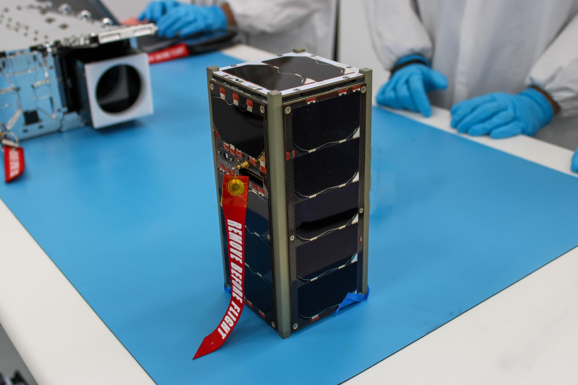
The ELaNa 43 (Educational Launch of Nanosatellites 43) mission includes eight CubeSats flying on Firefly Aerospace’s Alpha rocket for its “Noise of Summer” launch from Space Launch Complex-2 at Vandenberg Space Force Base, California. The 30-minute launch window will open at 9 p.m. PDT Wednesday, June 26 (12 a.m. EDT Thursday, June 27).
NASA’s CubeSat Launch Initiative (CSLI) is an ongoing partnership between the agency, educational institutions, and nonprofits, providing a path to space for educational small satellite missions. For the ELaNa 43 mission, each satellite is stored in a CubeSat dispenser on the Firefly rocket and deployed once it reaches sun-synchronous or nearly polar orbit around Earth.
CubeSats are built using standardized units, with one unit, or 1U, measuring about 10 centimeters in length, width, and height. This standardization in size and form allows universities and other researchers to develop cost-effective science investigations and technology demonstrations.
Read more about the small satellites launching on ELaNa 43:
CatSat – University of Arizona, Tucson
CatSat, a 6U CubeSat with a deployable antenna inside a Mylar balloon, will test high-speed communications. Once the CatSat reaches orbit, it will inflate to transmit high-definition Earth photos to ground stations at 50 megabits per second, more than five times faster than typical home internet speeds.
The CatSat design inspiration came to Chris Walker after covering a pot of pudding with plastic wrap. The CatSat principal investigator and professor of Astronomy at University of Arizona noticed the image of an overhanging light bulb created by reflections off the concave plastic wrap on the pot.
“This observation eventually led to the Large Balloon Reflector, an inflatable technology that creates large collecting apertures that weigh a fraction of today’s deployable antennas,” said Walker. The Large Balloon Reflector was an early-stage study developed through NASA’s Innovative Advanced Concepts program.
KUbeSat-1 – University of Kansas, Lawrence
The KUbeSat-1, a 3U CubeSat, will use a new method to measure the energy and type of primary cosmic rays hitting the Earth, which is traditionally done on Earth. The second payload, the High-Altitude Calibration will measure very high frequency signals generated by cosmic interactions with the atmosphere. KUbeSat-1 is Kansas’ first small satellite to launch under NASA’s CSLI.
MESAT-1 – University of Maine, Orono
MESAT-1, a 3U CubeSat, will study local temperatures across city and rural areas to determine phytoplankton concentration in bodies of water to help predict algal blooms. MESAT-1 is Maine’s first small satellite to launch under NASA’s CSLI.
R5-S4, R5-S2-2.0 - NASA’s Johnson Space Center
R5-S4 and R5-S2-2.0, both 6U CubeSats, will be the first R5 spacecraft launched to orbit to test a new, lean spacecraft build. The team will monitor how each part of the spacecraft performs, including the computer, software, radio, propulsion system, sensors, and cameras in low Earth orbit.
NASA and Firefly Aerospace engineers review the integration plan for the agency’s CubeSat R5 Spacecraft 4 (R5-S4) at Firefly Aerospace’s Payload Processing Facility at Vandenberg Space Force Base, California on Wednesday, April 24, 2024.NASA/Jacob Nunez-Kearny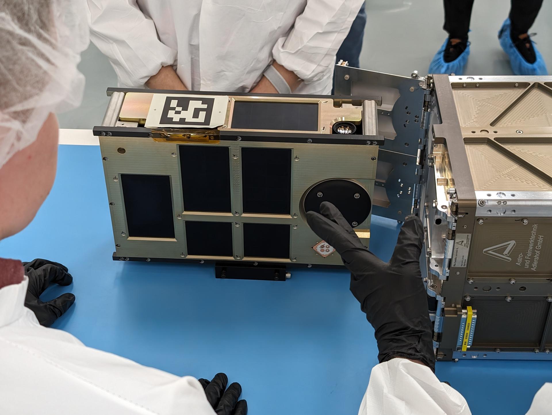
“In the near term, R5 hopes to demonstrate new processes that allows for faster and cheaper development of high-performance CubeSats,” said Sam Pedrotty, R5 project manager at NASA’s Johnson Space Center in Houston. “The cost and schedule improvements will allow R5 to provide higher-risk ride options to low-Technology Readiness Levels payloads so more can be demonstrated on-orbit.”
Serenity – Teachers in Space
Serenity, a 3U CubeSat equipped with data sensors and a camera, will communicate with students on Earth through amateur radio signals and send back images. Teachers in Space launches satellites as educational experiments to stimulate interest in space science, technology, engineering, and math among students in North America.
SOC-i – University of Washington, Seattle
Satellite for Optimal Control and Imaging (SOC-i), a 2U CubeSat, is a technology demonstration mission of attitude control technology used to maintain its orientation in relation to the Earth, Sun, or other body. This mission will test an algorithm to support autonomous operations with constrained attitude guidance maneuvers computed in real-time aboard the spacecraft. SOC-i will autonomously rotate its camera to capture images.
TechEdSat-11 (TES-11) – NASA’s Ames Research Center, California’s Silicon Valley
TES-11, a 6U CubeSat, is a collaborative effort between NASA researchers and students to evaluate technologies for use in small satellites. It’s part of ongoing experiments to evaluate new technologies in communications, a radiation sensor suite, and experimental solar panels, as well as to find ways to reduce the time to de-orbit.
NASA awarded Firefly Aerospace a fixed-price contract to fly small satellites to space under a Venture-Class Launch Services Demonstration 2 contract in 2020. NASA certified Firefly Aerospace’s Alpha rocket as a Category 1 in May, which authorized its use during missions with high risk tolerance.
NASA’s Launch Services Program is responsible for launching rockets delivering spacecraft that observe Earth, visit other planets, and explore the universe.
Follow NASA’s small satellite missions blog for launch updates.
Summer solstice 2024 is here! See celebrations at Stonehenge and beyond (photos)
NASA Invites Public to Share Excitement of NOAA GOES-U Launch
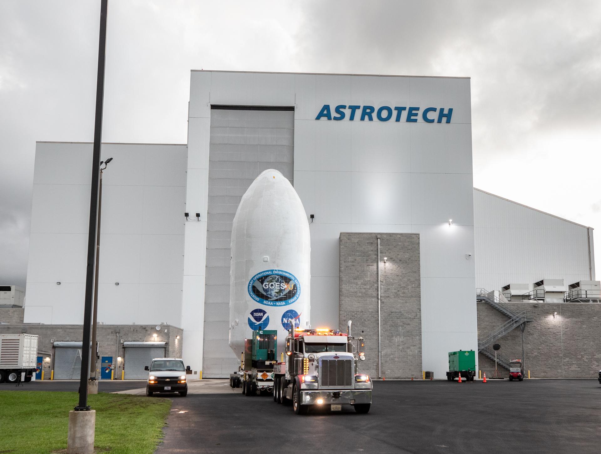
NASA invites the public to participate in virtual activities and events leading up to the launch of the NOAA (National Oceanic and Atmospheric Administration) GOES-U (Geostationary Operational Environmental Satellite-U) mission.
NASA is targeting a two-hour window opening at 5:16 p.m. EDT Tuesday, June 25, for the launch of the weather satellite aboard a SpaceX Falcon Heavy rocket from Launch Complex 39A at the agency’s Kennedy Space Center in Florida.
Live launch coverage will begin at 4:15 p.m. and will air on NASA+, the agency’s website, and other digital channels. Learn how to stream NASA TV through a variety of platforms.
As the fourth and final satellite in NOAA’s GOES-R Series, GOES-U will enhance meteorologists’ ability to provide advanced weather forecasting and warning capabilities. GOES-U also will improve the detection and monitoring of space weather hazards using a new compact coronagraph instrument.
Members of the public can register to attend the launch virtually. As a virtual guest, you will have access to curated resources, schedule changes, and mission-specific information delivered straight to your inbox. Following each activity, virtual guests will receive a commemorative stamp for their virtual guest passport.
Stay updated on the mission by following NASA’s GOES blog:
Virgin Galactic announces international crew for flight on new Delta class space plane
Contracts and Acquisition Integrity Law
In its functional leadership role, the Contracts and Acquisition Integrity Law Practice Group supports policy-level interactions with other elements of Government; provides specialized guidance and advice to the Offices of the General Counsel at NASA Field Centers regarding contract award, administration and litigation matters; and develops and coordinates NASA legal policy in these areas.
As a functional office to the NASA Administrator, the Contracts and Acquisition Integrity Law Practice Group provides legal advice regarding Headquarters-level contract selection, administration and termination decisions; drafts or comments on proposed legislation, regulations and executive orders; represents NASA in interagency meetings or bodies such as the Defense Acquisition Regulation (DAR) Council; and answers correspondence for the Administrator concerning contractual matters.
The Contracts and Acquisition Integrity Law Practice Group provides central services to organizations within NASA, principally legal advice and counsel to the NASA Office of Procurement and other Headquarters Offices regarding the statutes, regulations and policies governing Federal Government contracting. Central services provided by the Practice Group also include representing the agency in bid protests and contract-related litigation before the Government Accountability Office (GAO), the Court of Federal Claims (COFC), and the United States District Courts; disputes before the Armed Services Board of Contract Appeals (ASBCA); and, ultimately, any appeals of these decisions to the United States Courts of Appeals, including the Court of Appeals for the Federal Circuit.
ContactsAssociate General Counsel:
Scott Barber
Deputy Associate General Counsel:
Tory Kauffman
Tel: 202-358-4455
Director, Acquisition Integrity Program:
Monica Aquino-Thieman
Paralegal Specialist:
Rhonda Moss
Attorney Staff:
Michael Anderson
Young Cho
Allison Genco
Jennifer Howard
Victoria Kauffman
Stephen O’Neal
Vincent Salgado
Jessica Sitron
Adam Supple
Robert Vogt
OGC Leadership Directory— Contact Information for the Headquarters Leadership and Center Chief Counsels
ResourcesOGC Disclaimer: The materials within this website do not constitute legal advice. For details read our disclaimer.
Acquisition Integrity Program
In its functional leadership role, the Acquisition and Integrity Program (AIP) supports policy-level interactions with other governmental agencies combating procurement fraud. This Program provides specialized guidance and advice to the Office of the Chief Counsel at NASA Field Centers regarding procurement fraud matters; advises on affirmative litigation in the recovery of monies resulting from fraudulent activity on behalf of the Agency; and develops and coordinates NASA legal policy in these areas.
As a functional office to the NASA Administrator, the Acquisition Integrity Program provides legal advice regarding suspected fraud and other related irregularities in the acquisition process, suspected criminal standards of conduct violations, suspension and debarment decisions, and administrative agreements; represents NASA in interagency meetings or bodies such as the Department of Defense Procurement Fraud Working Group, and the Interagency Suspension and Debarment Committee; answers correspondence for the Administrator concerning acquisition integrity matters; and responds to Congressional inquiries and proposed Federal Acquisition Regulation rules concerning procurement fraud related issues.
The Acquisition Integrity Program provides centralized services to organizations within NASA regarding the statutes, regulations, and policies governing fraud. The Program is responsible for ensuring that significant allegations of fraud on NASA contracts, grants, cooperative agreements, funding instruments, and other commitments of NASA, are identified, investigated, and prosecuted. Centralized services provided by the Program also include: case referrals for investigation; interface with investigative agencies, U.S. Attorney’s Offices, and the Justice Department; coordination of criminal, civil, contractual, and administrative remedies; Suspension and Debarment recommendations and corresponding Administrative Agreements; education and training of the NASA workforce to prevent, detect, and deter procurement fraud; and educational outreach to the private sector on procurement fraud related issues.
ContactsDirector:
Monica Aquino-Thieman
Tel: 202-358-2262
Management and Program Analyst:
Laura Donegan
Attorney Staff:
Robert Vogt, Western Region Coordinator
Vacant, Central Region Coordinator
Vacant, Eastern Region Coordinator
Headquarters OGC Organization
OGC Leadership Directory— Contact Information for the Headquarters Leadership and Center Chief Counsels
- FAR Subpart 9.4, Suspension, Debarment and Ineligibility
- NASA FAR Supplement 1809.4
- 2 C.F.R. 180, Nonprocurement Debarment and Suspension
- 2 C.F.R. 1880, NASA Nonprocurement Debarment and Suspension
- NASA Policy Directive 2086.1, Coordination of Remedies Related to Fraud and Corruption
OGC Disclaimer: The materials within this website do not constitute legal advice. For details read our disclaimer.
Astronomers Trace the Family Tree of Stars Clustered in the Solar Neighborhood
Astronomers have pressed rewind on a cosmic video of the solar neighborhood, tracing the origins of young star clusters within 3,000 light-years of the Sun.
The post Astronomers Trace the Family Tree of Stars Clustered in the Solar Neighborhood appeared first on Sky & Telescope.
The Predator lands in Wakanda in new 'Predator vs Black Panther' series
These Bloodsucking Leeches Jump like Striking Cobras
Scientists observed leeches jumping like striking snakes, resolving long-standing debate
World's oldest wine found in 2000-year-old Roman tomb
World's oldest wine found in 2000-year-old Roman tomb
Could We Put Data Centers In Space?
Artificial intelligence has taken the world by storm lately. It also requires loads of band-end computing capability to do the near-miraculous things that it does. So far, that “compute,” as it’s known in the tech industry, has been based entirely on the ground. But is there an economic reason to do it in space? Some people seem to think so, as there has been a growing interest in space-based data centers. Let’s take a look at why.
Space-based data centers have several advantages over ground-based ones. The first and most obvious is the near-unlimited amount of space in space. Second, there are plenty of potential options for novel power and cooling technologies that can’t exist back on Earth. Third, using a space-based data center as a relay point for information could cut down on lag in data transfer between continents. Let’s look at each in turn.
One of the significant constraints for data centers is space – they require large amounts of it, and it is expensive in the areas where they are most needed (i.e., next to large population centers). The tech giants have massive budgets associated with real estate for data centers, and that amount will only continue to grow as their computational requirements increase. On the other hand, building a modular data center in space, with each launch adding additional computing power, is a reasonable way to infinitely expand a company’s hardware resources without the constraint of a physical location.
OrbitsEdge is a start-up company focusing on building space-based data centers. Here’s a video describing their business model.Credit – OrbitsEdge YouTube Channel
Data centers would also have access to novel power and cooling technologies in space. They could utilize solar panels directly attached to them to harness unlimited green energy, and ones in a high enough orbit could be powered effectively all the time, no matter weather conditions or Earth’s rotation. Power satellites run off a similar idea, and the underlying technology is already there; it hasn’t been applied to this use case yet.
Many data centers also use water cooling systems. While water is heavy and expensive to launch into orbit, plenty of asteroids have enough water on them to supply millions of data centers with all the cooling they need. A recent paper from researchers in South Africa looked at this process and found several asteroids with relatively close trajectories that could supply orbiting data centers with enough water to last centuries.
Space-based data centers could also allow for fast transmission between two points on the globe without sending data over a complicated path from one continent to another. Directly linking two computers is easier if they have a line of sight to the same relay point, such as a data center floating around the Earth. Using that data center to relay information between the two, similar to what Starlink currently does with satellite internet technology, would solve latency problems between far-away locations.
Diagram of the collaboration between Axiom, Kepler, and Skyloom for an orbital data center.Credit – Axiom Space
But there are also some hurdles. Data transfer rates on satellites aren’t up to speed with modern ground-based technologies, though that is consistently improving every year thanks to efforts like Starlink. Getting the hardware into orbit poses an obvious challenge and expense. However, that bar might be better lower with the continual development of Starship and its low-cost launch capability. Finally, coordinating across different governments, especially regarding wireless bandwidth, can be tricky, but without that coordination, the ability to talk across borders is severely limited.
None of those limitations are insurmountable; technologists and investors seem to realize that. As our own Alan Boyle reported in March, a company called Lumen Orbit raised $2.4 million only three months after being founded to bring data centers to space. Axiom Space, which we’ve mentioned in several articles in the last few years, is also partnering with Kepler Space and Skyloom to develop the world’s first functional space-based data center.
With this increased interest, it seems only a matter of time before some of the computing power that is enabling the AI and computing revolution makes its way into orbit. But for now, the question remains: who will be the first one to do it?
Learn More:
GeekWire – Lumen Orbit emerges from stealth and raises $2.4M to put data centers in space
Periola, Alonge, & Ogudo – Space-Based Data Centers and Cooling: Feasibility Analysis via Multi-Criteria and Query Search for Water-Bearing Asteroids Showing Novel Underlying Regular and Symmetric Patterns
UT – Starlinks are Easily Detected by Radio Telescopes
UT – Watch a Real-Time Map of Starlinks Orbiting Earth
Lead Image:
Artist’s conception of a Lumen Orbit space-based data center.
Credit – Lumen Orbit
The post Could We Put Data Centers In Space? appeared first on Universe Today.
When a dangerous asteroid threatens Earth, humanity will have to work together, NASA says
Coordinating an Airborne Lab Across the Globe with NASA’s Earth Science Project Office
Tracking the spread of harmful air pollutants across large regions requires aircraft, satellites, and diverse team of scientists. NASA’s global interest in the threat of air pollution extends into Asia, where it works with partners on the Airborne and Satellite Investigation of Asian Air Quality (ASIA-AQ). This international mission integrates satellite data and aircraft measurements with local air quality ground monitoring and modeling efforts across Asia.
Orchestrating a mission of this scale requires complicated agreements between countries, the coordination of aircraft and scientific instrumentation, and the mobilization of scientists from across the globe. To make this possible, ARC’s Earth Science Project Office (ESPO) facilitated each phase of the campaign, from site preparation and aircraft deployment to sensitive data management and public outreach.
“Successfully meeting the ASIA-AQ mission logistics requirements was an incredible effort in an uncertainty-filled environment and a very constrained schedule to execute and meet those requirements,” explains ASIA-AQ Project Manager Jhony Zavaleta. “Such effort drew on the years long experience on international shipping expertise, heavy equipment operations, networking and close coordination with international service providers and all of the U.S. embassies at each of our basing locations.”
Map of planned ASIA-AQ operational regions. Yellow circles indicate the original areas of interest for flight sampling. The overlaid colormap shows annual average nitrogen dioxide (NO2) concentrations observed by the TROPOMI satellite with red colors indicating the most polluted locations.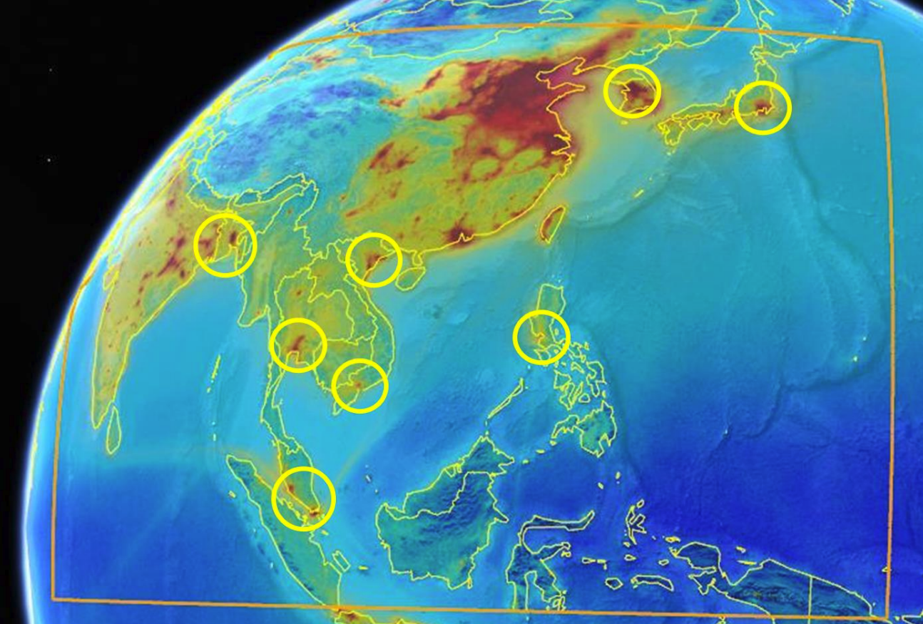
Understanding Air Quality Globally
ASIA-AQ benefits our understanding of air quality and the factors controlling its daily variability by investigating the ways that air quality can be observed and quantified. The airborne measurements collected during the campaign are directly integrated with existing satellite observations of air quality, local air quality monitoring networks, other available ground assets, and models to provide a level of detail otherwise unavailable to advance understanding of regional air quality and improve future integration of satellite and ground monitoring information.
ESPO’s Mission-Critical Contributions
- Facilitating collaboration between governmental agencies and the academic community by executing project plans, navigating bureaucratic hurdles, and consensus building.
- Mission planning for two NASA aircraft. AFRC DC-8 completed 16 science flights, totaling 125 flight hours. The LaRC GIII completed 35 science flights, totaling 157.7 flight hours.
- Enabling international fieldwork and workforce mobilization by coordinating travel, securing authorizations and documentation, and maintaining relationships with local research partners.
- Managing outreach to local governments and schools. ASIA-AQ team members showcased tools used for air quality science to elementary/middle/high school students. Recent news feature here.
The flying laboratory of NASA’s DC-8
NASA flew its DC-8 aircraft, picture above, equipped with instrumentation to monitor the quality, source, and movement of harmful air pollutants. Scientists onboard used the space as a laboratory to analyze data in real-time and share it with a network of researchers who aim to tackle this global issue.
“Bringing the DC-8 flying laboratory and US researchers to Asian countries not only advances atmospheric research but also fosters international scientific collaboration and education,” said ESPO Project Specialist Vidal Salazar. “Running a campaign like ASIA AQ also opens doors for shared knowledge and exposes local communities to cutting-edge research.”
Fostering Partnerships Through Expertise and Goodwill
International collaboration fostered through this campaign contributes to an ongoing dialogue about air pollution between Asian countries.
“NASA’s continued scientific and educational activities around the world are fundamental to building relationships with partnering countries,” said ESPO Director Marilyn Vasques. “NASA’s willingness to share data and provide educational opportunities to locals creates goodwill worldwide.”
The role of ESPO in identifying, strategizing, and executing on project plans across the globe created a path for multi-sectoral community engagement on air quality. These global efforts to improve air quality science directly inform efforts to save lives from this hazard that affects all.
Why smaller planets are better at building large moons
Heat Dome Causes Surge in Emergency Room Visits
With a heat dome baking the eastern U.S., emergency departments in New England and the Midwest have seen a spike in heat-related cases
How to Stay Safe Outdoors in Extreme Heat
Sizzling summer days can be a dangerous time to be outside. Here’s what to think about before heading into the heat and how to stay safe
HuskyWorks During Rover Testing
Einstein’s Time Dilation Calculated More Precisely Than Ever with Exploding Stars
Analyzing 1,504 supernovae into the distant universe, astronomers have shown the clearest evidence yet for cosmological time dilation as predicted by Einstein