
Feed aggregator
FAA plans to fine SpaceX $630,000 for alleged launch violations
ICESat-2 Hosts Third Applications Workshop
16 min read
ICESat-2 Hosts Third Applications WorkshopIntroduction
The NASA Ice, Cloud, and land Elevation Satellite-2 mission (ICESat-2), launched September 15, 2018, continues the first ICESat mission, delivering invaluable global altimetry data. Notwithstanding its icy acronym, ICESat-2 can do more than measure ice – in fact, the expanded acronym hints at these wider applications. From vegetation to inland surface water to bathymetry, ICESat-2 has emerged as a more versatile mission than originally planned, thanks in part to the ingenuity of research scientists, the Science Team (ST), and users of the data – see Figure 1.
Figure 1. A word cloud designed to highlight terms that occur most frequently in all ICESat-2 publications since 2018. The larger the word, the more often it is used.Figure credit: Aimee Neeley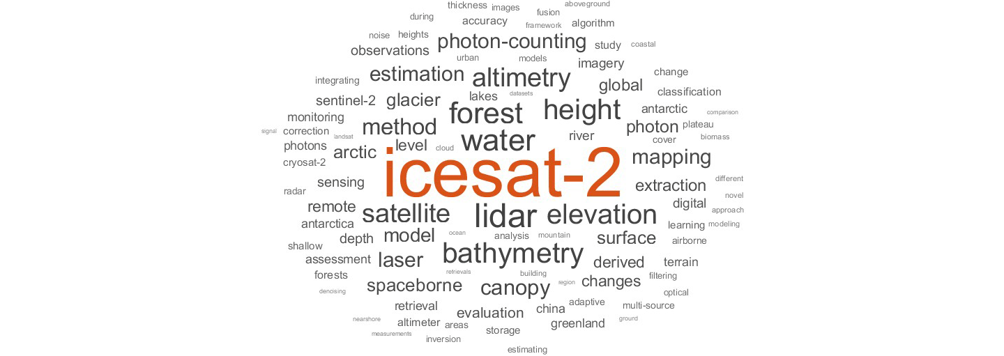
ICESat-2 was among the first NASA missions to develop an applications program that engages both scientists and potential users of the science data to accelerate user uptake. Throughout this program, ICESat-2 has demonstrated the value of Earth Observation data to end users, stakeholders, and decision makers. The ICESat-2 Early Adopter (EA; pre-launch) program, now the Applied User program (post-launch), was created to “promote applications research to provide a fundamental understanding of how ICESat-2 data products can be scaled and integrated into organizations, policy, business, and management activities to improve decision making efforts.” This article summarizes the workshop objectives met through plenary talks, lightning talks, an applied user panel, and a breakout session. The ICESat-2 Applications page contains more about the ICESat-2 Applications Program.
Motivation and Objectives
To meet Applications Program initiatives, the ICESat-2 Applications Team hosted its third Applications workshop June 3–4, 2024 at NASA’s Goddard Space Flight Center (GSFC) in a hybrid environment. A total of 113 participants registered for the workshop, representing multiple government agencies, including NASA Centers, non-profit organizations, and academic organizations – see Figure 2. Approximately 20 individuals attended the workshop in person with the majority participating online through the Webex platform. This workshop provided the space to foster collaboration and to encourage the conceptualization of applications not yet exploited.
Figure 2. A ‘donut’ plot showing the proportion of ICESat-2 Applications Workshop attendees identified by institution. This information was provided during the online registration process.Figure credit: Aimee Neeley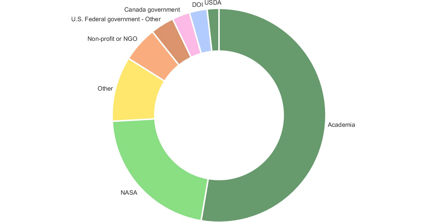
The objectives of the Applications workshop were to:
- provide an overview of the mission status, data products, and support services from the National Snow and Ice Data Center (NSIDC);
- build partnerships among applied users, data producers, and end users;
- foster synergies with all participants, decision makers, and satellite operators;
- identify new potential applications or products from ICESat-2;
- review available tools for extracting ICESat-2 data; and
- understand the challenges faced by applied users, data users, and end users, and identify solutions.
The remainder of this article will summarize the meeting highlights. Rather than give a strict chronological survey, the report is organized around the meeting objectives listed above. Readers interested in more details can find the full agenda and slide decks from individual presentations mentioned in this summary on the ICESat-2 Workshop website.
Workshop Overview and Structure
The agenda of the 2024 ICESat-2 Applications workshop was intended to bring together end-users, including ICESat-2 applications developers, satellite operators, and decision makers from government and nongovernmental entities to discuss the current state and future needs of the community – see Figure 3.
On the morning of the first day, the workshop participants contributed to a plenary session and ICESat-2 data tool demonstrations. These presentations were intended to provide a broad overview of the ICESat-2 mission, data, science, and applications. Plenary talks during the afternoon session provided an overview of the Earth Science-to-Action initiative and measuring impacts of science. The afternoon also included lightning talks from participants and an Applied User Panel. The second day consisted of a plenary presentation and more lightning talks from participants. The workshop ended with a thematic breakout session with pre-constructed topics and a report out to create a forum for direct interaction between participants.
Figure 3. Graphic showing the different levels of data available from the NASA Ice, Cloud, and land Elevation Satellite-2 (ICESat-2) mission.Figure credit: NASA, adapted from the National Snow and Ice Data Center (NSIDC) Distributed Active Archive Center’s ICESat-2 page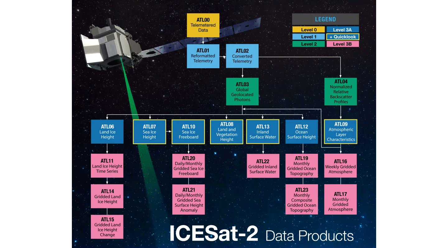
Objective 1: Provide an overview of the status of the mission and current data products and support services from the NSIDC.
To fulfill the first meeting objective, the workshop included a series of overview presentations given by ICESat-2 team members about the status of the ICESat-2 mission and its data products, as well as a review of the NASA Applied Sciences Program.
Aimee Neeley [NASA Goddard Space Flight Center (GSFC)/Science Systems and Applications Inc. (SSAI)—ICESat-2 Mission Applications Lead] and Molly Brown [GSFC/University of Maryland—ICESat-2 Mission Applications Scientist] served as cohosts for the event. Neeley opened the first day with a brief overview of workshop goals, logistics, and the agenda. On the second day she gave a brief overview of the agenda for the day and opened it up for questions.
Thomas Neumann [GSFC—ICESat-2 Project Scientist and Deputy Director of Earth Sciences Division] provided an overview of the ICESat-2 measurement concepts, which includes activity of GPS positioning, pointing angle, altimetry measurements, and ground processing. He continued with an overview of the Advanced Topographic Laser Altimeter System (ATLAS) instrument, the wavelength and spatial resolution of the lasers, and the distributed data products. Neumann presented the mission outlook, with an expected lifespan until December 2035.
Walter Meier [University of Colorado, Boulder (UC, Boulder)—NSIDC DAAC Scientist] provided an overview of ICESat-2 data tools and services. He walked the audience through the ICESat-2 data website, as well as the instructional guides that are available for all the tools and services. Meier provided an overview of ICESat-2 standard data products – see Figure 3. Most of the products have a ~45-day latency while quick look data sets have an ~3-day latency. Future data sets include ATL24 and ATL25 and quick look data sets for ATL03, ATL20, and ATL25. Next, he described webinars and tutorials, access tools, and customization services for different users and workflows, including graphical user interfaces and programmatic tools in Earthaccess and the NSIDC website.
Helen Amanda Fricker [Scripps Institution of Oceanography, University of California (UC), San Diego—ICESat-2 ST Leader and Professor] provided an overview of the ST members and ST goals. Fricker described the ST goals to: 1) provide coordination between the team, project science office, and NASA headquarters; 2) use science talks, posters, and social events to stimulate collaboration within the ST and across disciplines; and 3) maintain the visibility of the ICESat-2 mission through publications, press releases, white papers, open science, and synergies with other missions. Next, Fricker shared the list of ST members that can be found on the ICESat-2 website. She concluded with an overview of a recent publication by Lori Magruder [University of Texas, Austin] and coauthors published in Nature Reviews.
Stephanie Schollaert Uz [NASA GSFC—Applied Sciences Manager] provided an overview of the NASA Applied Science Program, including the current NASA Earth Science Satellite missions that are monitoring Earth systems. The NASA Applied Science Programs “tackle challenges on our home planet in areas for which Earth science information can respond to the urgent needs of our time.” Earth science data products are used to “inform decisions and actions on management, policy and business.” Uz provided examples of applications using Earth science data, including economic activity, active fire mapping, food security, and monitoring air quality – see Figure 4.
Figure 4. Near real-time active fire mapping as well as air quality monitoring and forecasting are available via NASA’s Fire Information for Resource Management System (FIRMS).Figure credit: FIRMS U.S./Canada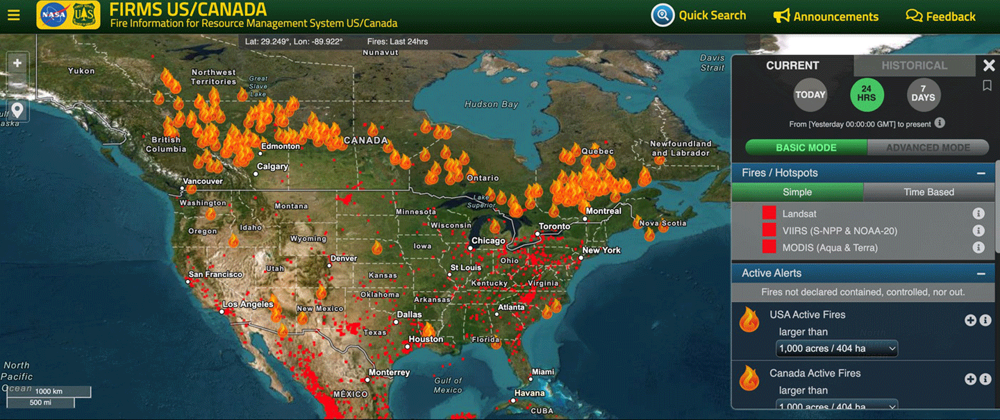
Molly E. Brown [University of Maryland—ICESat-2 Mission Applications Scientist] began her presentation by defining the term application in the context of this workshop, which includes “innovative uses of mission data products in decision-making activities for societal benefit.” Brown stated that the ICESat-2 Mission Applications program “works to bring our data products into areas where they can help inform policy or decisions that benefit the public.” End users include the private sector, academia, and government agencies. Brown described the benefits of the program and strategies to extend ICESat-2 to new communities – see Figure 5. Brown concluded with an overview of recent publications and new research efforts to assess the impact of ICESat-2 data.
Figure 5. Strategies to extend ICESat-2 to new communities through activities and trainings such as those hosted by the Applied Remote Sensing Training (ARSET) program.Figure credit: Molly Brown
Mike Jasinski [NASA GSFC, Hydrological Sciences Laboratory—Assistant Chief for Science] provided an overview of ICESat-2 inland water standard and quick look data products, ATL13QL and ATL22QL. ICESat-2 covers approximately one million lakes each year. Jasinski also listed application areas for water resources decision support, including river elevation and discharge, lake and reservoir water balance and management, and validation of Surface Water and Ocean Topography (SWOT) data. He provided metrics for each data product and quick look product and the advantages and disadvantages of ATL13 and ATL22 data products.
Mary D. Ari [Centers for Disease Control and Prevention, Office of Science—Senior Advisor for Science] provided an overview of the Science Impact Framework (SIF). Ari explained that our partners and public need “evidence to support practice or policy or decision making, accountability for public finds, and research focus to advocate for research priority.” A major goal is to translate findings into practice or action. Next, she presented ways by which impact can be measured, including bibliometrics (quantitative) and value (qualitative). Ari further explained the Science Impact Framework (SIF), which includes five domains of scientific influence: disseminating science, creating awareness, catalyzing action, effecting change, and shaping the future – see Figure 6.
Figure 6. The Science Impact Framework, which allows the impact of scientific work to be quantified and to determine if the science we produce is being put into action.Figure credit: Mary Ari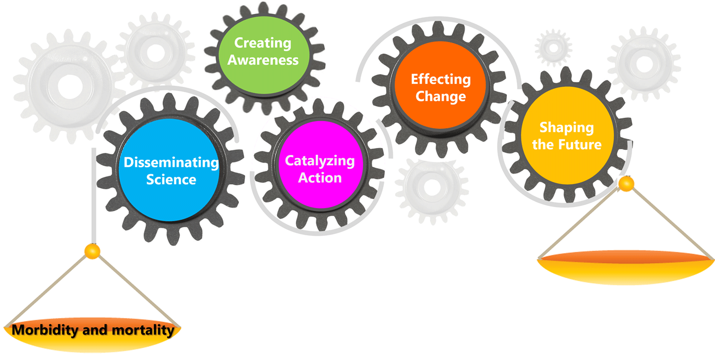
Woody Turner [NASA Headquarters—ICESat-2 Program Applications Lead] provided an overview of NASA’s Earth Science to Action Strategy. Turner explained that NASA’s Earth Science to Action strategy is integral to the Earth Science Division’s 2024–2034 strategic plan. The overall strategy has two objectives: 1) observe, monitor, and understand the Earth System and 2) deliver trusted information to drive Earth resilience activities. He also summarized the “three key pillars” for this new Earth Action paradigm to 1) be user centered, 2) build bridges between research, technology, flight, data, and Earth Action elements, and 3) scale up existing efforts to get NASA data into the hands of end users. Lastly, Turner listed NASA’s core values, including safety, integrity, inclusion, teamwork, excellence, trustworthiness, innovation, and collaboration.
Objective 2: Review available tools for extracting ICESat-2 data for a diverse community.
To achieve this objective, the meeting included a series of presentations in which each speaker described a different tool that is being used to download and analyze ICESat-2 data.
Jessica Scheick [University of New Hampshire] provided an overview of a set of Python tools, named icepyx, that can be used to obtain and manipulate ICESat-2 data. Scheick, who developed icepyx, described how the tools address challenges with ICESat-2 data. Lastly, she performed a live demonstration of icepyx.
Tyler Sutterley [Applied Physics Laboratory/University of Washington] presented a live demonstration of Sliderule, an ICESat-2 plugin module that uses an application programming interface (API) to “query a set of ATL03 input granules for photon heights and locations based on a set of photon-input parameters that select the geographic and temporal extent of the request.”
Joanna D. Millstein [Colorado School of Mines] provided an overview of CryoCloud, which is a “JupyterHub built for NASA cryosphere communities in collaboration with 2i2c.” The goal of CryoCloud is to create a “simple and cost-effective managed cloud environment for training and transitioning new users to cloud workflows and determining community best practices.” CryoCloud makes it possible to “process data faster, minimize downloading and democratize science.” The CryoCloud GitHub provides access to a Slack channel, trainings and tutorials, and community office hours.
Mikala Beig [UC, Boulder—NSIDC User Services] provided and overview of OpenAltimetry, a platform for visualizing and downloading surface elevation data from ICESat and ICESat-2. OpenAltimetry was developed to alleviate the challenges faced by researchers, including the “steep learning curves and heavy demands on computational resources” necessary to download and manipulate large volumes of data. The strengths of OpenAltimetry include fostering user engagement, lowering technical hurdles for visualizing data, and allowing deeper data exploration. Lastly, Beig demonstrated the platform for the audience – see Figure 7.
Figure 7. Searching ICESat-2 tracks in OpenAltimetry, a map-based data visualization and discovery tool for altimetry data.Figure credit: Mikala Beig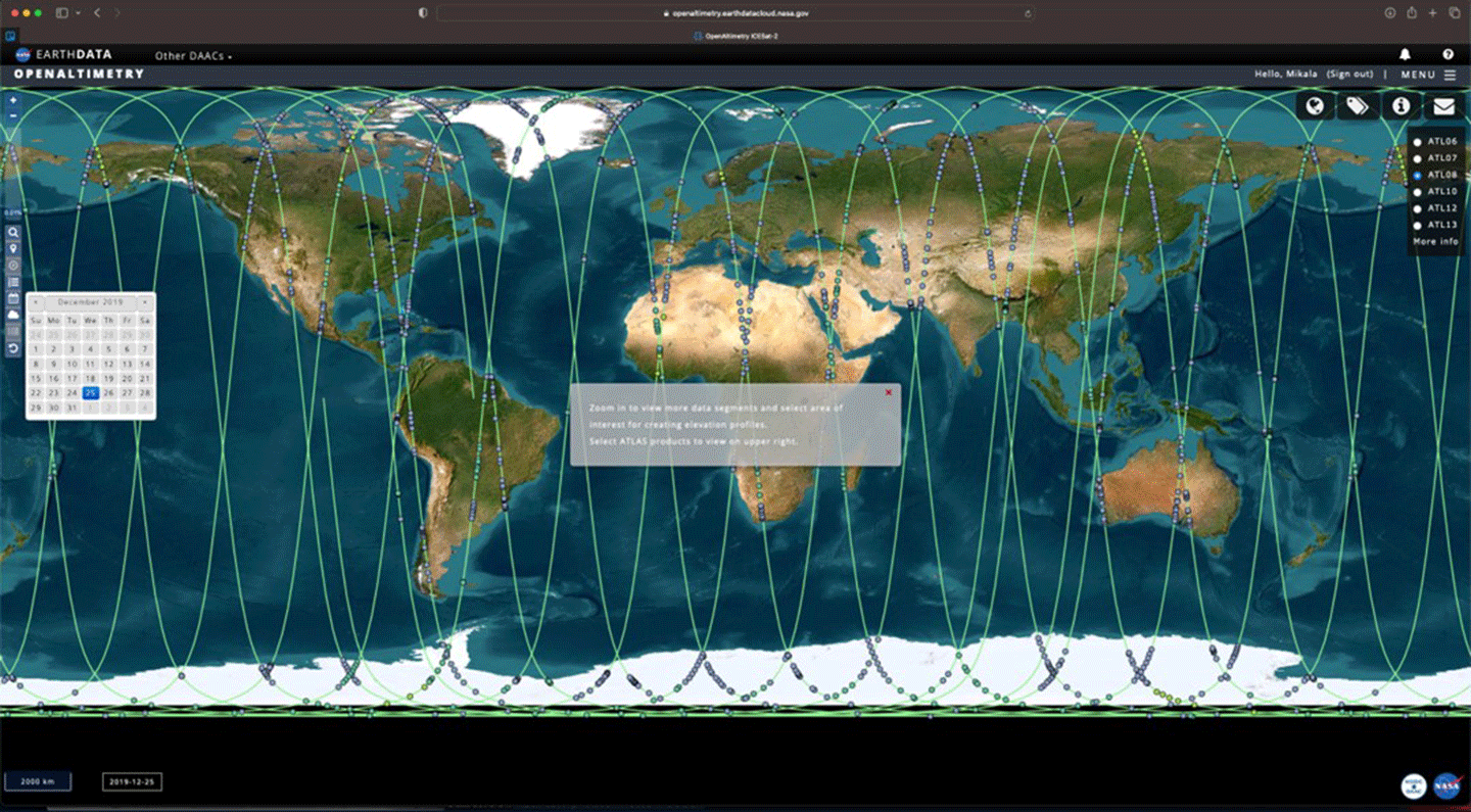
Objectives 3 and 4: Foster synergies between all participants; Identify new potential applications or products from ATLAS data not currently under investigation.
To meet these two meeting objectives, workshop organizers scheduled a round of lightning talks, where a series of presenters gave five-minute presentations on their research or activities. The talks are distilled below. The reader is directed online to find formal presentation titles and additional information. There was also an applied user panel and a breakout session to facilitate synergies between participants and identify new applications.
Younghyun Koo [Lehigh University/ Cooperative Institute for Research in Environmental Science (CIRES)] described a method to filter landfast ice (or sea ice “fastened” to the coastline) for accurate examination of thermodynamic and dynamic sea ice features using the ICESat-2 ATL10 data product – see Figure 8.
Chandana Gangodagamage [OeilSat—Principal Investigator] described the company’s efforts to track freshwater in the Congo River for the purposes of water resources management and other water-related applications that require river bathymetry data.
Daniel Scherer [Technischen Universität München (TUM), Germany] provided an overview of the ICESat-2 River Surface Slope (IRIS), a global reach-scale water surface slope dataset that provides average and extreme water slopes from ICESat-2 observations. The data can be dowloaded from Zenodo.
Louise Croneborg-Jones [Water In Sight—Chief Executive Officer] described her company’s effort to use satellite data and mobile and cloud technology to digitize river and rainfall observation at scale in Malawi. Water In Sight has emphasized getting local communities involved in monitoring water resources to increase observations of water levels for conservation.
Ravindra Duddu [Vanderbilt University] provided an overview on a project called Modeling Antarctic Iceshelf Calving and Stability (MAGICS), which involves using computation, data, and machine learning to map the rift and crevasse configurations of ice shelves in Antarctica to better understand calving events.
Shawn Serbin [GSFC] discussed use of harmonized above ground products from ICESat-2 and other earth observing platforms, including Global Ecosystem Dynamics Investigation (GEDI), Soil Moisture Active Passive (SMAP), and Moderate Resolution Imaging Spectroradiometer (MODIS), for terrestrial ecosystem carbon cycle reanalysis and near-term, iterative forecasting for North America and the globe.
Wengi Ni-Meister [Hunter College of the City University of New York—ICESat-2 Early Adopter] summarized an effort to retrieve canopy and background reflectivity ratio from ICESat-2 data and use it for the retrieval of vegetation cover and snow distribution in boreal forests.
Morgaine McKibben [GSFC–Plankton, Aerosol, Clouds, ocean Ecosystem (PACE) Applications Lead] provided an overview of NASA’s PACE mission, suggesting possible synergies between ICESat-2 and PACE with the intent of opening the door for further discussion on collaboration between the two missions. (To learn more about planned applications for PACE, see Preparing for Launch and Assessing User Readiness: The 2023 PACE Applications Workshop. (Also published in The Earth Observer, Nov–Dec 2023, 35:6, 25–32.)
Anthony Campbell [GSFC/ University of Maryland, Baltimore County] discussed his group’s research into using ICESat-2 data to monitor changes in coastal wetland migration, including coastal elevation and canopy height.
Brian A Campbell [NASA’s Wallops Flight Facility (WFF)—ICESat-2 Mission Education Lead] described the Global Learning and Observations to Benefit the Environment (GLOBE) program’s network of citizen scientists who collect several different kinds of data using the GLOBE Observer app. He highlighted one data type with particular relevance to ICESat-2. GLOBE Trees – see Figure 8 – equips citizen scientists with the tools to take tree height measurements using their mobile devices. These observations could then be compared to data from NASA satellite missions.
Figure 8. NASA’s Global Learning and Observations to Benefit the Environment (GLOBE) has developed an app called GLOBE Trees that allows users take measurements of tree height data using a mobile device. Those data can then be uploaded, and scientists can use them to validate satellite tree height measurement (e.g., from ICESat-2/ATLAS).Figure credit: Brian Campbell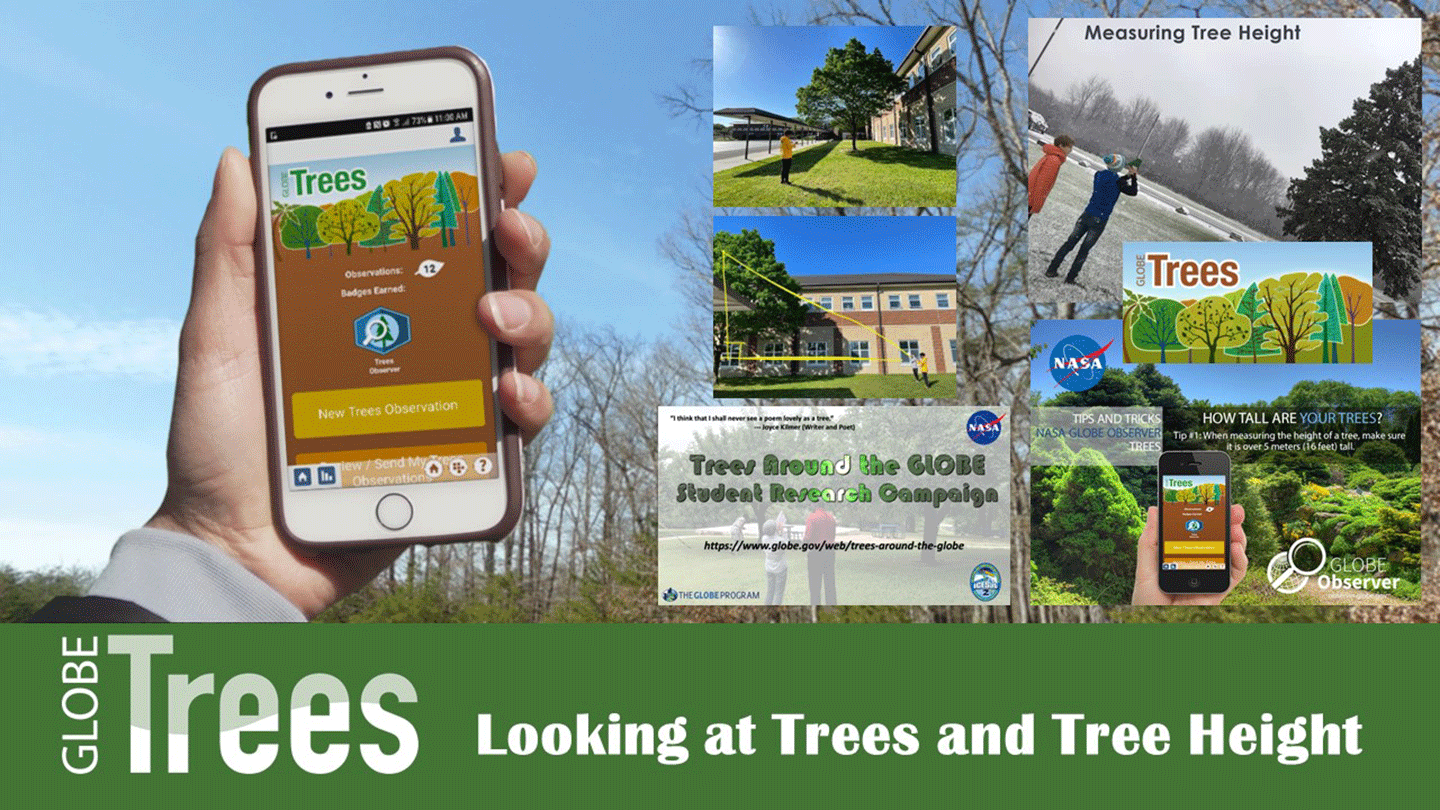
Caio Hamamura [University of Florida/School of Forest, Fisheries & Geomatics Sciences—Postdoctoral Associate] summarized a literature review his team had conducted of studies using ICESat-2 data for land and vegetation applications as well as results of an assessment of the current capability and limitations of ICESat-2 data for land and vegetation applications – see Figure 9.
Figure 9. Illustration of the ATL18 canopy height product at 1 km (~0.6 mi) spatial resolution at the global scale. The height values represent the median of all ATL18 height estimates within a given grid size of 1 km.Figure credit: Jordan Borak and Ciao Hamamura
Jacob Comer [Cultural Site Research and Management Foundation] summarized results from an evaluation of the use of ICESat-2 data for archaeological prospection and documentation of archaeological sites – particularly in the Federal States of Micronesia.
Juradana M. Iqrah [University of Texas at San Antonio] described her group’s effort to obtain high resolution sea ice classification and freeboard information from ICESat-2 ATL03 observations to understand the impact of global warming on the melting and retreat of polar sea ice cover.
Michael MacFerrin [National Oceanic and Atmospheric Administration (NOAA) National Centers for Environmental Information (NCEI)—Coastal Digital Elevation (DEM) Model Team] provided an overview of the NOAA/CIRES ICESat-2 Validation of Elevations Reporting Tool (IVERT) tool, which is used to generate land-based validation statistics of digital elevation models (DEM) anywhere in the word using the ATL03 and ATL08 datasets – see Figure 10.
Figure 10. Digital Elevation Model output before and after Hurricane Michael in Florida, October 2018.Figure credit: Michael MacFerrin
Gretchen Imahori [NOAA National Geodetic Survey, Remote Sensing Division] presented an overview of satellite derived bathymetry using ICESat-2 data, including the new Level 3 (L3) bathymetry data product (ATL24) that will be available later in 2024 – see Figure 11.
Figure 11. Bathymetry data from ICESat-2 have been used across a wide variety of morphologies [some of which are illustrated in the photos above] and disciplines. Figure credit: Gretchen Imahori and the ICESat-2 bathymetry working group
Objectives 5 and 6: Understand the challenges faced by applied, data users, and end users and identify solutions. Build partnerships between applied users, data producers, and end users.
To achieve these two objectives, planners organized an applied user panel and a breakout session as means to foster conversation among participants. The applied user panel consisted of five panelists– three participating virtually and two in-person. The presenters in the session shared their responses to three prepared discussion prompts: 1) an introduction of ICESat-2 data products; 2) use of ICESat-2 data products for their application; and 3) potential data latency impacts. The conversation was brief, but it provided a unique opportunity to hear from experienced applied users.
A breakout session consisted of pre-planned discussion prompts through two virtual breakout groups and one in-person group. Group One discussed questions that covered examination of ice crevassing and rifting, community tools for shallow water mapping, and slope measurement bias and uncertainties. Group Two discussed a variety of current and potential surface water applications, identified challenges using ICEat-2 data, and developed suggestions to increase the accessibility and usability of ICESat-2 data products. Group Three covered a gamut of topics, including potential products for Alaskan and Canadian communities, increased accessibility to products, and applications through central cloud storage systems, central repositories and detailed documentation, and the desire for future topic-specific workshops and focus sessions.
Conclusion
The 2024 NASA ICESat-2 Applications Workshop was the third in a series of workshops – with the first workshop occurring in 2012, six years prior to launch. The EA program was transitioned to the Applied User program, which deployed a post-launch program per the NASA Early Adopter Handbook “that acts as a continuation of the Early Adopter program to engage with Communities of Practice and Potential.” This workshop provided the space to foster collaboration and conceptualization of applications not yet exploited that may be developed using ICESat-2 data products. The workshop met its objectives and created an environment that fostered collaboration between participants. The workshop was a success, and participants requested another one focused on a thematic topic. Updates, future workshops, and other events will be posted on the ICESat-2 ‘Get Involved’ page.
Aimee Renee Neeley
NASA’s Goddard Space Flight Center/Science Systems and Applications, Inc.
aimee.neeley@nasa.gov
El pódcast en español de la NASA regresa con una nueva temporada
Read this news release in English here.
Para celebrar el Mes de la Herencia Hispana, la NASA publica nuevos contenidos para Universo curioso de la NASA, el primer pódcast en español de la agencia, que inicia ahora su segunda temporada. La temporada de cinco semanas comienza el martes, con nuevos episodios disponibles semanalmente.
Escucha el avance de la segunda temporada de Universo curioso de la NASA.
En cada episodio, Universo curioso destaca las contribuciones de la fuerza laboral hispana y latina de la NASA al trabajo de la agencia en el ámbito de la exploración de la Tierra y el espacio en beneficio de todos.
“Mediante el pódcast Universo curioso de la NASA, estamos entusiasmados de contar la historia de los esfuerzos de la NASA para que el espacio esté al alcance de más gente de todo el mundo”, dijo Tonya McNair, administradora asociada adjunta de la Dirección de Misiones de Operaciones Espaciales de la NASA en Washington. “En la segunda temporada, escucharán a trabajadores hispanos y latinos de la NASA, como la directora de vuelo Diana Trujillo y el astronauta Marcos Berríos, que ayudan a dirigir algunas de las misiones de exploración espacial más vitales de la agencia e inspiran al mundo a través del descubrimiento.”
Los episodios se centran en algunas de las principales misiones de la NASA, acercando las maravillas de la exploración, la tecnología espacial y los descubrimientos científicos al público hispanohablante del mundo entero.
“Este pódcast pone en relieve la dedicación de la NASA a hacer que el conocimiento esté a disposición de todos, independientemente de su lengua materna”, dijo Shahra Lambert, asesora principal de la NASA para la participación pública. “Al compartir la emoción de las misiones de la NASA en el segundo idioma más hablado en los EE.UU. y en todo el mundo, estamos amplificando nuestro alcance y posiblemente allanando el camino para una fuerza de trabajo en ciencia, tecnología, ingeniería y matemáticas más diversa en el futuro.”
El primer episodio de Universo curioso se emitió en 2021, como parte de la cobertura en español del lanzamiento del telescopio espacial James Webb. En 2023, el programa fue seleccionado como “Programa que nos encanta” por Apple Podcasts Latinoamérica.
Presentado por Noelia González, especialista en comunicaciones del Centro Goddard de Vuelo Espacial de la NASA en Greenbelt, Maryland, en el pódcast invitamos a los oyentes a emprender un viaje a una de las lunas heladas de Júpiter, a oír acerca de los dos primeros años de descubrimientos del telescopio espacial James Webb, así como a conocer la trayectoria de un astronauta de Puerto Rico y de una directora de vuelo colombiana para llegar a la NASA.
Los episodios cubrirán el próximo lanzamiento de Europa Clipper en octubre de 2024, una misión que tiene como objetivo determinar si existen lugares bajo la superficie de la luna helada de Júpiter, Europa, que puedan albergar vida.
A continuación figura la lista completa de los nuevos episodios, así como sus fechas de publicación:
- Martes, 17 de septiembre: Avance de la segunda temporada
- Martes, 24 de septiembre: Diana Trujillo: De Cali a la Luna y Marte
- Martes, 1 de octubre: Europa Clipper: Un viaje poético a la luna de Júpiter
- Martes, 8 de octubre: Marcos Berríos: Cómo convertirse en astronauta de la NASA
- Martes, 15 de octubre: Explorando el cosmos con Webb
Universo curioso de la NASA es una iniciativa conjunta de los programas de comunicación en español y de audio de la agencia. La nueva temporada, así como los episodios anteriores, están disponibles en Apple Podcasts, Spotify y el sitio web de la NASA.
Escucha el pódcast en:
https://www.nasa.gov/universo-curioso-de-la-nasa
-fin-
María José Viñas / Cheryl Warner
Sede, Washington
240-458-0248 / 202-358-1600
maria-jose.vinasgarcia@nasa.gov / cheryl.m.warner@nasa.gov
NASA’s Spanish-language Podcast Returns for New Season
Lee este comunicado de prensa en español aquí.
In celebration of Hispanic Heritage Month, NASA is releasing new content for Universo curioso de la NASA, the agency’s first Spanish-language podcast, now in its second season. A five-week season starts Tuesday with new episodes released weekly.
Listen to the preview of the second season of Universo curioso de la NASA.
In each episode, Universo curioso highlights the contributions of NASA’s Hispanic and Latino workforce to the agency’s work in Earth and space exploration for the benefit of all.
“Through the Universo curioso de la NASA podcast, we are thrilled to tell the story of NASA’s efforts to open space to more people from across the world,” said Tonya McNair, deputy associate administrator for NASA’s Space Operations Mission Directorate in Washington. “In the second season, you’ll hear from NASA’s Hispanic and Latino workforce, like flight director Diana Trujillo and astronaut Marcos Berríos, helping lead some of the agency’s most vital space exploration missions and inspiring the world through discovery.”
Episodes focus on some of NASA’s top missions, bringing the wonder of exploration, space technology, and scientific discoveries to Spanish-speaking audiences around the world.
“This podcast highlights NASA’s dedication to making knowledge available to all, regardless of their native language,” said Shahra Lambert, NASA senior advisor for engagement. “By sharing the excitement of NASA’s missions in the second most spoken language in the U.S. and around the world, we are amplifying our outreach and possibly paving the way for a more diverse STEM workforce in the future.”
The first episode of Universo curioso ran in 2021, as part of the agency’s Spanish coverage of the launch of its James Webb Space Telescope. In 2023, the show was selected as a “Podcast We Love” by Apple Podcasts Latin America.
Hosted by Noelia González, communications specialist at NASA’s Goddard Space Flight Center in Greenbelt, Maryland, listeners are invited to go on a journey to one of Jupiter’s icy moons, hear about the first two years of discoveries of the James Webb Space Telescope, as well as learn about an astronaut from Puerto Rico’s and a Colombian flight director’s path to NASA.
Episodes will cover the upcoming launch of Europa Clipper in October 2024, a mission that aims to determine whether there are places below the surface of Jupiter’s icy moon, Europa, that could support life.
A complete list of the new episodes, as well as their release dates, is as follows:
- Tuesday, Sept. 17: Introducing the Second Season
- Tuesday, Sept. 24 Diana Trujillo: From Cali to the Moon and Mars
- Tuesday, Oct. 1 Europa Clipper: A Poetic Journey to Jupiter’s Moon
- Tuesday, Oct. 8 Marcos Berríos: How to Become a NASA Astronaut
- Tuesday, Oct. 15: Exploring Cosmos with Webb
Universo curioso de la NASA is a joint initiative of the agency’s Spanish-language communications and audio programs. The new season, as well as previous episodes, are available on Apple Podcasts, Spotify, and NASA’s website.
Listen to the podcast at:
https://www.nasa.gov/universo-curioso-de-la-nasa
-end-
María José Viñas / Cheryl Warner
Headquarters, Washington
240-458-0248 / 202-358-1600
maria-jose.vinasgarcia@nasa.gov / cheryl.m.warner@nasa.gov
Engineer Zaida Hernandez
Comet Tsuchinshan-ATLAS nears the sun this month. Will it be visible to the naked eye?
Sols 4307-4308: Bright Rocks Catch Our Eyes
- Curiosity Home
- Science
- News and Features
- Multimedia
- Mars Missions
- The Solar System
2 min read
Sols 4307-4308: Bright Rocks Catch Our Eyes NASA’s Mars rover Curiosity captured this image while exploring a rock-strewn channel of Gediz Vallis on the Red Planet. Mission scientists were particularly intrigued to investigate several bright-toned rocks (at the middle-right, bottom-right and bottom-center of the image), similar to rocks that Curiosity had encountered previously that were unexpectedly rich in sulfur. This image was taken by Left Navigation Camera aboard Curiosity on Sol 4306 — Martian day 4,306 of the Mars Science Laboratory Mission — on Sept. 16, 2024 at 12:47:18 UTC.NASA/JPL-Caltech
Earth planning date: Monday, Sept. 16, 2024
We made good progress through Gediz Vallis in the weekend drive, landing in a segment of the channel containing a mix of loose rubble and other channel-filling debris. Amongst the jumbled scene, though, particular objects of interest caught our eye: bright rocks. In past workspaces in Gediz Vallis, similar bright rocks have been associated with very high to almost pure sulfur contents. As all good geologists know, however, color is not diagnostic, so we cannot assume these are the same as sulfur-rich rocks we have encountered previously. The only way to know is to collect data, and that was a significant focus of today’s plan.
We planned multiple mosaics across the examples of bright rocks visible in the image above. Mastcam and ChemCam RMI will cover “Bright Dot Lake” and “Sheep Creek” both in the right midfield of the image. Mastcam imaged the example in the bottom right corner of the image at “Marble Falls,” and ChemCam LIBS targeted one of the small bright fragments along the bottom of the image at “Blanc Lake.” There was also a small bit of bright material in the workspace, but unfortunately, it was not reachable by APXS. APXS analyzed a spot near the bright material, at target “Frog Lake,” and MAHLI was able to tack on a few extra images around that target that should capture the bright material. MAHLI also imaged a vuggy target in the workspace at “Grasshopper Flat.” The wider context of the channel was also of interest for imaging, so we captured the full expanse of the channel with one Mastcam mosaic, and focused another on mounds distributed through the channel at target “Copper Creek.”
Even with all this rock imaging, we did not miss a beat with our environmental monitoring. We planned regular RAD, REMS, and DAN measurements, mid and late day atmospheric dust observations, a cloud movie, and dust devil imaging.
Our drive is planned to take us up onto one of the ridges in the channel. Will we find more bright rocks there? Or something new and unexpected that was delivered down Gediz Vallis by some past Martian flood or debris flow? Only the channel knows!
Written by Michelle Minitti, Planetary Geologist at Framework
Share Details Last Updated Sep 17, 2024 Related Terms Explore More 2 min read Reaching New Heights to Unravel Deep Martian History! Article 22 hours ago 5 min read Sols 4304-4006: 12 Years, 42 Drill Holes, and Now… 1 Million ChemCam Shots! Article 4 days ago 3 min read Sols 4302-4303: West Side of Upper Gediz Vallis, From Tungsten Hills to the Next Rocky Waypoint Article 4 days ago Keep Exploring Discover More Topics From NASA MarsMars is the fourth planet from the Sun, and the seventh largest. It’s the only planet we know of inhabited…
All Mars ResourcesExplore this collection of Mars images, videos, resources, PDFs, and toolkits. Discover valuable content designed to inform, educate, and inspire,…
Rover BasicsEach robotic explorer sent to the Red Planet has its own unique capabilities driven by science. Many attributes of a…
Mars Exploration: Science GoalsThe key to understanding the past, present or future potential for life on Mars can be found in NASA’s four…
There Could be a Way to Fix Spacecraft at L2, Like Webb and Gaia
Billions of dollars of observatory spacecraft orbit around Earth or in the same orbit as our planet. When something wears out or goes wrong, it would be good to be able to fix those missions “in situ”. So far, only the Hubble Space Telescope (HST) has enjoyed regular visits for servicing. What if we could work on other telescopes “on orbit”? Such “fixit” missions to other facilities are the subject of a new NASA paper investigating optimal orbits and trajectories for making service calls on telescopes far beyond Earth.
Some of the most productive orbiting telescopes operate at the Sun-Earth Lagrange points L1 and L2. Currently, those positions afford us some very incredible science. What they can’t afford is easy access for repairs and servicing. That limits the expected lifetime of facilities such as JWST to about 10-15 years. In the future, more missions will be deployed a Lagrange points. These include the Nancy Grace Roman Telescope, ESA’s PLATO and ARIEL missions, and the Large Ultraviolet Optical Infrared Surveyor (LUVOIR).
Artist’s impression of the Nancy Grace Roman Space Telescope, named after NASA’s first Chief of Astronomy. This spacecraft will orbit at SEL2, far from Earth. Credits: NASAThese observatories need propellants for attitude thrusters to help them stay ‘in place’ during their observations. There’s only so much “gas” you can send along with these observatories. In addition, components wear out, as they did with HST. So, people are looking at ways to extend their lifetimes through servicing missions. If failing components can be replaced and propellant delivered, the lifetimes of these observatories should be extended quite a bit, giving astronomers more bang for the observational buck.
Planning Future Spacecraft Servicing MissionsResearchers at the Satellite Servicing Capability Office (SSCO) at the Goddard Space Flight Center (GSFC) investigated the possibilities for servicing missions to distant space telescopes. In a recently released paper, they focus on the feasibility of on-orbit refueling missions for space telescopes orbiting at Sun-Earth Lagrange 2 (SEL2).
There are many challenges. For one thing, present-day launch technologies are (at this writing) inadequate to do that kind of mission at such distances. Clearly, the technology has to advance for servicing visits to take place. In addition, it’s important to remember that current telescopes, such as Gaia and JWST, weren’t designed for such access. However, future telescopes can be fitted with servicing ports, etc. to enable servicing. Finally, there are the challenges of actually getting the servicing missions to the observatories.
Illustration of OSAM-1 (bottom) grappling Landsat 7. This servicing mission concept was discontinued by NASA, but remains a good example of what’s needed to perform repairs and refueling to orbiting spacecraft. Credits: NASAThe Goddard team focused on this final issue by computing models of various launch and orbital solutions for such missions. Not only did they take into account the launch trajectories themselves, but also Sun-Earth-Lagrange point dynamics, plus the relative positions of observatories at SEL2. In addition, the team considered the stability of the observatories during and after rendezvous and attachment. All of these factors count when planning whether or not a servicing vehicle can be launched at a reasonable cost to extend the lifetime of the observatory enough to make the effort worth the time and expense.
Getting a Spacecraft Refuelling Mission UnderwayThe team created models for a theoretical mission for on-orbit fuelling at SEL2. That’s where JWST and Gaia are sitting, for example, along with WMAP, Planck, and others. The paper examines robotic refueling missions out to SEL2 for modeling purposes.
To do that, however, there must be an optimal trajectory for the robotic spacecraft to take out to SEL2. They need to be able to perform autonomous navigation to the correct point in space. Once at the target observatory, the refueling robot would then need to make a careful approach for its docking maneuvers. That requires on-orbit assessment of the target’s motion in space with respect to the Sun as well as its position in its SEL2 orbit. Docking itself can affect the observatory’s position and motion and the robot needs to take that into account, as well. The idea is to keep the observatory in the same position after docking.
However, the big question is: how do we get it out there inexpensively, fast, and safe?
The Goddard team primarily investigated the best and most efficient trajectories to get to SEL2. In particular, they looked at the best approaches to get to the Gaia spacecraft, which will run out of its propellant sometime in the next year. They also examined JWST as a possible target for such a mission. If such a mission was possible today, those observatories would gain years of “point and shoot” access to the Universe.
How to Get ThereIn their paper, the team looks at two approaches to the SEL2 refueling mission. One is a direct launch trajectory from Earth and the other is a spacecraft leaving from a geostationary transfer orbit (GTO). They assumed that the point of the mission was the fastest possible restoration of telescope operation. That dictates the shortest and safest possible trajectory along which the spacecraft can maintain constant thrust.
The Goddard team created a “forward design” approach for computing low-energy and low-thrust transfers from an Earth departure orbit to a space telescope orbiting the SEL2 point. Then they did the same for a servicing spacecraft leaving from a point in geostationary space. Essentially, either an Earth-departure or GTO-centric departure will work. Once the robotic servicing mission leaves Earth orbit, it travels at low thrust during a spiraling transit to SEL2. Once there, it does a rendezvous with the target, matches its motion in space, and then “locks on” to perform its delivery mission.
It’s important to remember that a launch from Earth or GTO is part of several solutions to SEL2 servicing missions. The team’s analysis resulted in a simplified process of generating possible orbits and trajectories for such activities. You can read the full text of their detailed analysis of the different trajectory solutions at the link below.
For More InformationMission Design for Space Telescope Servicing at Sun-Earth L2
JWST Home Page
Gaia Telescope
The post There Could be a Way to Fix Spacecraft at L2, Like Webb and Gaia appeared first on Universe Today.
We need to start telling women how pregnancy changes their brain
We need to start telling women how pregnancy changes their brain
Some flowers may have evolved long stems to be better ‘seen’ by bats
Some flowers may have evolved long stems to be better ‘seen’ by bats
Snoring isn't just a nuisance, it's dangerous. Why can't we treat it?
Snoring isn't just a nuisance, it's dangerous. Why can't we treat it?
9 firsts in 5 days: Polaris Dawn crew lands from history-making SpaceX mission
Technicians Work to Prepare Europa Clipper for Propellant Loading
NASA’s Europa Clipper mission moves closer to launch as technicians worked on Wednesday, Sept. 11, inside the Payload Hazardous Servicing Facility to prepare the spacecraft for upcoming propellant loading at the agency’s Kennedy Space Center in Florida.
The spacecraft will explore Jupiter’s icy moon Europa, which is considered one of the most promising habitable environments in the solar system. The mission will research whether Europa’s subsurface ocean could hold the conditions necessary for life. Europa could have all the “ingredients” for life as we know it: water, organics, and chemical energy.
Europa Clipper’s launch period opens on Thursday, Oct. 10. It will lift off on a SpaceX Falcon Heavy rocket from Kennedy’s Launch Complex 39A. The spacecraft then will embark on a journey of nearly six years and 1.8 billion miles before reaching Jupiter’s orbit in 2030.
The spacecraft is designed to study Europa’s icy shell, underlying ocean, and potential plumes of water vapor using a gravity science experiment alongside a suite of nine instruments including cameras, spectrometers, a magnetometer, and ice-penetrating radar. The data Europa Clipper collects could improve our understanding of the potential for life elsewhere in the solar system.
Photo credit: NASA/Kim Shiflett
The Next President Should End NASA’s Space Launch System Rocket
Rather than building an obsolescent, obscenely-over-budget jumbo rocket, NASA should turn to building truly innovative space technologies and plan a realistic lunar landing program
Celebrating the First Earth Day Event at NASA Headquarters
4 min read
Celebrating the First Earth Day Event at NASA Headquarters Photo. Young attendees pose in front of the NASA Worm at the Earth Day celebration at NASA HQ.Photo credit: NASA
Introduction
Organized by the Science Mission Directorate’s Science Support Office (SSO), NASA hosted its 12th annual Earth Day Celebration event from April 18–19, 2024. For the first time ever, the two-day event was held at NASA Headquarters (HQ) in Washington, DC.
The in-person event, which was free and open to the public, featured the newly installed Earth Information Center (EIC) exhibit – see Photos 1–4. The event featured 17 hands-on activities offered in NASA HQ’s East Lobby as well as two adjacent outdoor tents. Event participants were given an activity passport called the “Passport to Fun” listing all the activities and encouraging attendees to visit the stations and interact with NASA staff – see Figure 1. After completing six or more activities, attendees were able to claim giveaway items, e.g., lenticulars, NASA bags, posters, and calendars.
Photos 1–3. Student attendees at the Earth Information Center (EIC) interactive exhibit.Photo credits: NASA Photos 1–3. Student attendees at the Earth Information Center (EIC) interactive exhibit.Photo credits: NASA Photos 1–3. Student attendees at the Earth Information Center (EIC) interactive exhibit.Photo credits: NASA Photo 4. Mark Subbarao [GSFC—Scientific Visualization Studio Lead] engages attendees with NASA science in front of the EIC Hyperwall. Photo credit: NASA Figure 1. Earth Day Activity Passport.Figure credit: NASA
Prior to the event, Trena Ferrell [GSFC—Earth Science Education and Public Outreach Lead] arranged for groups of students from several local schools to visit the NASA Earth Day event. This included over 300 students from DuVal High School, Morgan State University, Howard University, Prince George’s County Environmental Academy, Prince George’s County Virtual Academy, International Hispanic School, and homeschoolers. On April 19, all of the students who were present at that time gathered for a plenary in the Webb Auditorium. Ferrell welcomed the attendees and provided introductions to prepare them for a virtual presentation by former NASA astronaut Paul Richards, who interacted with attendees and answered questions for roughly 20 minutes.
After Richard’s presentation, the attendees heard from Karen St. Germain [NASA HQ—Director of NASA’s Earth Science Division], whose in-person remarks emphasized to the students the crucial albeit less publicized studies that NASA does of our home planet. Related to this year’s Earth Day theme, “Water Touches Everything,” she discussed the ability of NASA’s Earth observing satellites to track water in all its forms as it circulates throughout the Earth system. St. Germain then answered questions from the audience for 15 minutes – see Photos 5–8.
Photo 5.Trena Ferrell [GSFC—Earth Science Education and Public Outreach Lead] welcomed student attendees to the Earth Day event.Photo credit: NASA Photos 6–7. Former NASA astronaut Paul Richards takes audience questions at the NASA Earth Day event.Photo credit: NASA Photos 6–7. Former NASA astronaut Paul Richards takes audience questions at the NASA Earth Day event.Photo credit: NASA Photo 8. Karen St. Germain [NASA Headquarters—Director of NASA’s Earth Science Division] provided remarks and answered student questions in the Webb Auditorium.Photo credit: NASANASA Administrator Bill Nelson visited the event on April 19, accompanied by Karen St. Germain and several NASA staff members who guided him as he explored the activities offered – see Photos 9–10.
Photo 9. NASA Administrator Bill Nelson [center, rear] spent time circulating among the NASA Earth Day hands-on activities. Here, he visits the “Measuring Light the Landsat Way” activity station, where Mike Taylor [GSFC/Science Systems and Applications, Inc.—Landsat Outreach Team] [left] explains how Landsat utilizes the electromagnetic spectrum and spectral signatures to better understand Earth. Photo credit: NASA Photo 10. [Left to right] Faith McKie [Acting NASA Press Secretary], Bill Nelson, Karen St. Germain, and Tom Wagner [Associate Director for Earth Action in the Earth Science Division of NASA’s Science Mission Directorate] during the Earth Day media briefing. Photo credit: NASAThroughout the two-day event, it is estimated that as many as 1500 public participants attended along with the 300 students already discussed. While SSO staff distributed 500 activity passports, many small groups and families shared a single passport. SSO staff estimates that the true number of participants may be close to 1500 – see Photos 11–19.
Photo 11. A young Earth Day participant interacts with Ellen Gray [NASA GSFC—Earth Science News Team].Photo credit: NASA Photo 12. Jenny Mottar [NASA HQ—Art Director for the Science Mission Directorate] and Kevin Miller [GSFC—SSO Senior Graphic Designer] hand out “Water Touches Everything” NASA Earth Day posters to student attendees.Photo credit: NASA Photos 13. Ross Walter [GSFC—Data Visualizer and Animator, Landsat Outreach Team] engages with students at the “Viewing Earth From Above with Landsat” station.Photo credit: NASA Photos 14. Students explore the Chesapeake Bay as seen by Landsat 8 with a large, vinyl floor mat.Photo credit: NASA Photo 15. Students play a Global Ecosystem Dynamics Investigation (GEDI) Jeopardy game at the “GEDI Knights Measure Forests from Space” table.Photo credit: NASA Photo 16. Student attendees make ultraviolet-bead bracelets and Helio Big Year buttons at the Heliophysics station.Photo credit: NASA Photo 17. Young attendees engage with Valerie Casasanto [GSFC—Ice, Cloud, and land Elevation Satellite-2 (ICESat-2) Outreach Lead], who helps them work on a three-dimensional glacier puzzle at the “ICESat-2: Ice, Trees, and Earth Height, If You Please!” station.Photo credit: NASA Photo 18. Young attendees engage with the “Meteorite Map Challenge.”Photo credit: NASA Photo 19. Dorian Janney [GSFC—GPM Outreach Specialist] engages visitors at the “Connect the Drops” station, where visitors learn how and why measuring global precipitation helps us better understand our home planet.Photo credit: NASAConclusion
NASA’s first Earth Day Celebration at NASA Headquarters was quite successful. While attendance was lower than previous events held at the more heavily trafficked Union Station or the National Mall, there was a steady stream of people throughout the exhibit on both days. It was also a great opportunity to showcase the new EIC to the public. Earth Day is the largest event organized annually by the SSO. This event requires months of planning, cross-divisional coordination, and intensive design of the hands-on activities – all carried from conceptualization through numerous revisions to implementation by more than 100 individuals from across the agency. This combined effort of SSO staff and assisting organizations results in an event that brings together thousands of visitors from a broad spectrum of ages and backgrounds to enjoy NASA science. This event would not have been possible were it not for the incredible efforts and collaboration put forth by so many of NASA’s outreach professionals. The SSO is grateful for all who helped to make this year’s Earth Day event a success and looks forward to Earth Day 2025.
Dalia Kirshenblat
NASA’s Goddard Space Flight Center/Global Science & Technology, Inc. (GSFC/GST)
dalia.p.zelmankirshenblat@nasa.gov
Could We Find Primordial Black Holes in the Solar System?
Astronomers have observed three types of black holes in the Universe. Stellar-mass black holes formed from the collapse of a massive star, intermediate mass black holes found in some star clusters, and supermassive black holes that lurk in the centers of galaxies. But there is a fourth type that remains hypothetical an unobserved. Known as primordial black holes, they are thought to have formed from tiny fluctuations in the hot and dense early cosmos. Since they wouldn’t have formed from stars or mergers, they could have a much smaller mass. And with small masses, primordial black holes would be tiny. Their event horizons would be smaller than an apple, perhaps as small as a grain of sand. You can see why they would be hard to find.
If they exist, these dustmote singularities would be a perfect candidate for dark matter. This is not a new idea. Observations of dark matter have ruled out stellar-mass black holes and even planet-mass ones, but they haven’t quite ruled out primordial black holes. So they are a possible explanation for dark matter, but how would we prove it? A new study on the arXiv tries to find out.
Observational constraints on primordial black holes over various mass ranges. Credit: M. Cirelli (2016)
The authors begin by noting that if dark matter really is composed of primordial black holes, then they must be clustered around regular matter in the way dark matter does. There must be a halo of tiny black holes surrounding the Milky Way, and there must be primordial black holes scattered throughout our solar system. The gravitational pull of these tiny black holes should therefore affect the motion of planets, asteroids, and comets in detectable ways. Previous searches turned up nothing, but the authors wanted to know whether the effect would be significant enough to observe with our current technology.
So they ran several computer simulations to calculate the size of the effect. Since the gravitational pull of a single black hole would be tiny, the team looked at how nearby encounters would shift the orbits of solar system bodies. We describe orbital motion by ephemerides tables, so they used simulations to determine how the ephemerides would change over time. What they found was that even if we took a decade’s worth of ephemerides observations, the effect of primordial black holes would be an order of magnitude smaller than the limits of observation. In other words, even if primordial black holes exist their effect is way too tiny to observe in our solar system.
While the result is a bit disappointing, it does contradict a few studies that argue current observations rule out primordial black holes as dark matter. Though they are an unlikely solution to this cosmic mystery, they are still in the game.
Reference: Thoss, Valentin, and Andreas Burkert. “Primordial Black Holes in the Solar System.” arXiv preprint arXiv:2409.04518 (2024).
The post Could We Find Primordial Black Holes in the Solar System? appeared first on Universe Today.
NASA Completes Spacecraft to Transport, Support Roman Space Telescope
The spacecraft bus that will deliver NASA’s Nancy Grace Roman Space Telescope to its orbit and enable it to function once there is now complete after years of construction, installation, and testing.
Now that the spacecraft is assembled, engineers will begin working to integrate the observatory’s other major components, including the science instruments and the telescope itself.
“They call it a spacecraft bus for a reason — it gets the telescope to where it needs to be in space,” said Jackie Townsend, the Roman deputy project manager at NASA’s Goddard Space Flight Center in Greenbelt, Maryland. “But it’s really more like an RV because it has a whole assortment of functions that enable Roman to accomplish its scientific goals while out there too.”
Those goals include surveying wide swaths of the universe to study things like: dark energy, a mysterious cosmic pressure thought to accelerate the universe’s expansion; dark matter, invisible matter seen only via its gravitational influence; and exoplanets, worlds beyond our solar system.
The mission’s science wouldn’t be possible without a spacecraft to transport the telescope, point the observatory toward different cosmic targets, provide power, communicate with Earth, control and store instrument data, and regulate Roman’s temperature. Nearly 50 miles of electrical cabling are laced throughout the assembly to enable different parts of the observatory to communicate with each other.
The spacecraft will also deploy several major elements that will be stowed for launch, including the solar panels, deployable aperture cover, lower instrument Sun shade, and high-gain antenna. It’s also responsible for collecting and beaming down data, which is no small task for a space observatory that will survey the cosmos like Roman will.
“Roman will send back 1.4 terabytes of data per day, compared to about 50 to 60 gigabytes from the James Webb Space Telescope and three gigabytes from the Hubble Space Telescope,” said Jason Hylan, the Roman observatory manager at NASA Goddard. “Webb’s daily downlink is roughly comparable to 13 hours of YouTube video at the highest quality while Roman’s would amount to about 2 weeks.”
This top-down view shows NASA’s Nancy Grace Roman Space Telescope’s spacecraft bus from another angle. It rests atop an aluminum ring that will not be part of the observatory and is surrounded by an enclosure used in testing to ensure electromagnetic interference will not affect the bus’s sensitive electronics. The bus is covered in gray bagging material to prevent contamination –– even tiny stray particles could affect its performance.NASA/Chris Gunn A Goddard Grand Slam
This milestone is the culmination of eight years of spacecraft design work, building, and testing by hundreds of people at Goddard.
“Goddard employees were the brains, designers, and executors. And they worked with vendors who supplied all the right parts,” Townsend said. “We leaned on generations of expertise in the spacecraft arena to work around cost and schedule challenges that arose from supply chain issues and the pandemic.”
One time- and money-saving technique the team came up with was building a spacecraft mockup, called the structural verification unit. That allowed them to do two things at once: complete strength testing on the mockup, designed specifically for that purpose, while also assembling the actual spacecraft.
The spacecraft’s clever layout also allowed the team to adapt to changing schedules. It’s designed to be modular, “more like Trivial Pursuit pie pieces than a nesting egg, where interior components are buried inside,” Townsend said. “That’s been a game-changer because you can’t always count on things arriving in the order you planned or working perfectly right away with no tweaks.” It also increased efficiency because people could work on different portions of the bus at the same time without interfering with each other.
The slightly asymmetrical and hexagonal spacecraft bus is about 13 feet (4 meters) wide by 6.5 feet (2 meters) tall and weighs in at 8,400 pounds (3,800 kilograms).
While it may look small in this photo, the spacecraft bus for NASA’s Nancy Grace Roman Space Telescope is 13 feet (4 meters) wide by 6.5 feet (2 meters) tall and weighs in at 8,400 pounds (3,800 kilograms). In this photo, it rests atop an aluminum ring that will not be part of the observatory. The bundles of wires on top are part of more than 50 miles of cabling laced throughout the assembly to enable different parts of the observatory to communicate with each other.NASA/Chris Gunn
One reason it doesn’t weigh more is that some components have been partially hollowed out. If you could peel back some of the spacecraft’s panels, you’d find superthin metallic honeycomb sandwiched between two slim layers of metal. And many of the components, such as the antenna dish, are made of strong yet lightweight composite materials.
When the spacecraft bus was fully assembled, engineers conducted a comprehensive performance test. Prior to this, each component had been tested individually, but just like with a sports team, the whole unit has to perform well together.
“The spacecraft passed the test, and now we’re getting ready to install the payload –– Roman’s instruments and the telescope itself,” said Missie Vess, a spacecraft systems engineer for Roman at NASA Goddard. “Next year, we’ll test these systems together and begin integrating the final components of the observatory, including the deployable aperture cover, outer barrel assembly, and solar panels. Then we’ll finally have ourselves a complete observatory, on track for launch by May 2027.”
To virtually tour an interactive version of the telescope, visit:
https://roman.gsfc.nasa.gov/interactive
The Nancy Grace Roman Space Telescope is managed at NASA’s Goddard Space Flight Center in Greenbelt, Maryland, with participation by NASA’s Jet Propulsion Laboratory and Caltech/IPAC in Southern California, the Space Telescope Science Institute in Baltimore, and a science team comprising scientists from various research institutions. The primary industrial partners are BAE Systems, Inc in Boulder, Colorado; L3Harris Technologies in Rochester, New York; and Teledyne Scientific & Imaging in Thousand Oaks, California.
By Ashley Balzer
NASA’s Goddard Space Flight Center, Greenbelt, Md.
Media Contact:
Claire Andreoli
claire.andreoli@nasa.gov
NASA’s Goddard Space Flight Center, Greenbelt, Md.
301-286-1940