
Feed aggregator
The vital, overlooked role of body fat in shaping your health and mind
ESA investigates high-stakes Amazon tipping point
For decades, the Amazon rainforest has quietly absorbed vast quantities of human-generated carbon dioxide, helping to slow the pace of climate change. Recent evidence, however, suggests that this vital natural buffer may be weakening – though uncertainties remain.
To help close this critical knowledge gap, European and Brazilian researchers have gathered deep in the Amazon to carry out an ambitious European Space Agency-funded field campaign.
How Forbes Sent E-mails to the Future—And What Happened 20 Years Later
Twenty years ago Forbes.com sent hundreds of thousands of messages to the future. Here’s what happened next
How to Send a Message to Future Civilizations
When written knowledge is more ephemeral than ever, how can we pass on what’s important?
Does Information Ever Really Disappear? Physics Has an Answer
Black holes and quantum mechanics present a paradox about the preservation of information
Nuclear-Waste Arks Are a Bold Experiment in Protecting Future Generations
Designing nuclear-waste repositories is part engineering, part anthropology—and part mythmaking
Can a Buried Time Capsule Beat Earth’s Geology and Deep Time?
A ridiculous but instructive thought experiment involving deep time, plate tectonics, erosion and the slow death of the sun
The Sun Left Home in a Hurry
By exploring the edge of the solar system, astronomers have estimated how long our star stuck around its siblings after birth.
The post The Sun Left Home in a Hurry appeared first on Sky & Telescope.
Asteroid 2024 YR4 Was Earth's First Real-Life Defense Test
At this point in history, astronomers and engineers who grew up watching Deep Impact and Armageddon, two movies about the destructive power of asteroid impacts, are likely in relatively high ranking positions at space agencies. Don’t Look Up also provided a more modern, though more pessimistic (or, unfortunately, realistic?), look at what might potentially happen if a “killer” asteroid is found on approach to Earth. So far, life hasn’t imitated art when it comes to potentially one of the most catastrophic events in human history, but most space enthusiasts agree that it's worth preparing for when it will. A new paper, available in pre-print on arXiv, from Maxime Devogèle of ESA’s Near Earth Object (NEO) Coordination Centre and his colleagues analyzes a dry run that happened around a year ago with the discovery of asteroid 2024 YR4.
How Influential People Map Their Social World
The same brain areas that help us map physical space help us chart social connections, and the best relationship cartographers have most clout
How Technology and Friendship Preserved a 20-Year E-mail Time Capsule
Scientific American’s editor in chief David M. Ewalt reflects on a 20-year experiment in e-mailing the future
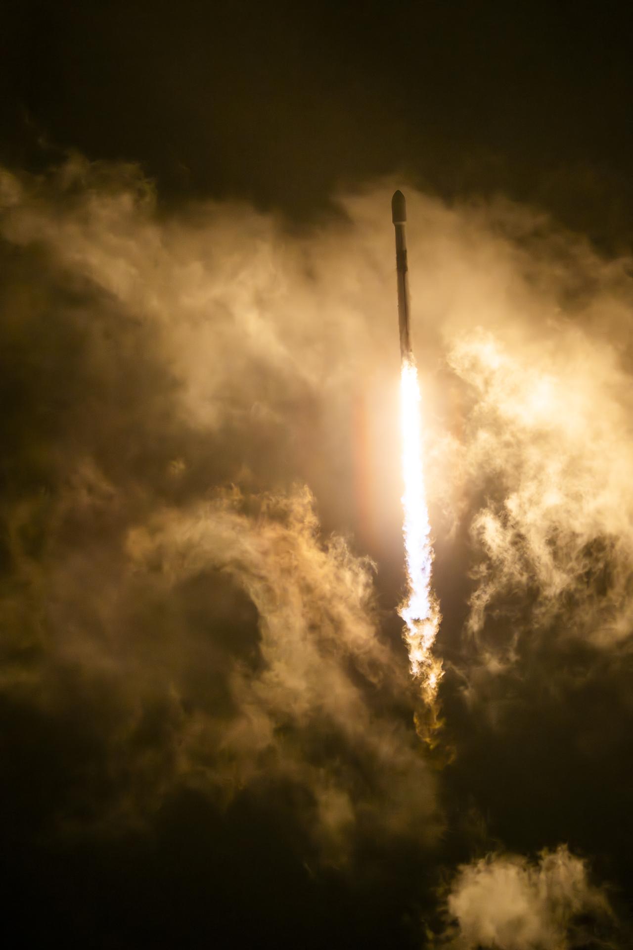
Sentinel-6B launch highlights
Copernicus Sentinel-6B was launched on 17 November 2025, ready to continue a decades-long mission to track the height of the planet’s seas – a key measure of climate change. The satellite was carried into orbit on a Falcon 9 rocket from the Vandenberg Space Force Base in California, US.
Sentinel-6B follows in the footsteps of its predecessor, Sentinel-6 Michael Freilich, which was launched in 2020. The mission is the reference radar altimetry mission that continues the vital record of sea-surface height measurements until at least 2030.
Copernicus Sentinel-6 has become the gold standard reference mission to monitor and record sea-level rise. The mission’s main instrument is the Poseidon-4 dual-frequency (C-band and Ku-band) radar altimeter. Developed by ESA, the altimeter measures sea-surface height. It also captures the height of ‘significant’ waves as well as wind speed to support operational oceanography.
NASA, SpaceX Launch US-European Satellite to Monitor Earth’s Oceans
About the size of a full-size pickup truck, a newly launched satellite by NASA and its partners will provide ocean and atmospheric information to improve hurricane forecasts, help protect infrastructure, and benefit commercial activities, such as shipping.
The Sentinel-6B satellite lifted off aboard a SpaceX Falcon 9 rocket from Launch Complex 4 East at Vandenberg Space Force Base in central California at 9:21 p.m. PST on Nov. 16. Contact between the satellite and a ground station in northern Canada occurred about 1 hour and 30 minutes later at 10:54 p.m. All systems are functioning normally.
“Understanding tidal patterns down to the inch is critical in protecting how we use our oceans every day on Earth,” said Nicky Fox, associate administrator, Science Mission Directorate at NASA Headquarters in Washington. “Sentinel-6B will build upon the legacy of Sentinel-6 Michael Freilich by making sea level measurements that improve forecasts used by communities, businesses, and operations across the country. It also will support a safer reentry for our astronauts returning home, including crew from Artemis Moon missions.”
Sea levels vary from place to place, and the satellite will provide accurate measurements at both local and global scales — all from hundreds of miles above in low Earth orbit. Those observations form the basis for U.S. flood predictions, which are crucial for safeguarding coastal infrastructure, real estate, energy storage sites, and other coastal assets. Sentinel-6B will take over for Sentinel-6 Michael Freilich, which launched in 2020 and later became the official reference satellite for global sea level measurements, providing sea surface height measurements against which those from other satellites are compared for accuracy.
The satellite comes from a collaboration between multiple partners, including NASA, ESA (European Space Agency), EUMETSAT (European Organisation for the Exploitation of Meteorological Satellites), and the National Oceanic and Atmospheric Administration (NOAA). It also is part of the European Union’s family of Copernicus missions.
“Collaboration between partners is key to a mission such as Sentinel-6, and my thanks go to everyone involved in developing, launching, and operating this exceptional satellite, which follows in the footsteps of the first Sentinel-6, Michael Freilich,” said Simonetta Cheli, director, ESA’s Earth Observation Programmes. “This achievement demonstrates what can be accomplished when international agencies and industries work together toward a shared goal. Sentinel-6B will ensure we continue to collect the high-precision data needed to understand our changing climate, safeguard our oceans and support decisions that protect coastal communities around the world.”
The two satellites make up the Copernicus Sentinel-6/Jason-CS (Continuity of Service) mission, the latest in a series of ocean-observing radar altimetry missions that have monitored Earth’s changing seas since the early 1990s.
As with its predecessor, Sentinel-6B satellite also will provide key information about wind speeds, wave heights, atmospheric temperature, and humidity. Moreover, because water expands as its temperature increases, researchers can tell which parts of the ocean are warmer than others based on where the sea surface height is greater.
Combined with data from other instruments, that knowledge can help in forecasting marine weather, including the development of hurricanes, which intensify with warmer water. Also, because large currents are taller than surrounding waters due to their higher temperatures, sea surface measurements can shed light on interactions between the Gulf Stream, for example, and nearby waves. Where they meet, seas can become rougher, presenting a hazard to even the largest ships.
“Sentinel-6B is a testament to the value of NASA’s partnership missions to put actionable satellite information and science into the hands of decision-makers on the ground,” said Karen St. Germain, director, NASA Earth Science Division at the agency’s headquarters. “Sentinel-6B will collect ocean surface observations that will inform decisions critical to coastal communities, commercial shipping and fishing, national defense, and emergency preparedness and response. This is what NASA does — puts advanced technology and science into action for the benefit of the nation.”
When Sentinel-6B reaches its operating elevation, the satellite will fly about 30 seconds behind Sentinel-6 Michael Freilich, which carries identical science instruments. Once the mission finishes cross-calibrating the data collected by the two, Sentinel-6 Michael Freilich will move into a different orbit, and Sentinel-6B will take over the role of official reference satellite, orbiting Earth about 13 times a day at 830 miles (1,336 kilometers) above the surface.
“Sentinel-6B demonstrates the versatile Earth science applications made possible by expertly engineered, space-based technology. The satellite’s powerful suite of instruments will measure about 90% of Earth’s oceans down to fractions of an inch — continuing to add to a vital dataset that America and a growing global community depend on,” said Dave Gallagher, director, NASA’s Jet Propulsion Laboratory (JPL) in Southern California.
More about Sentinel-6B
Copernicus Sentinel-6/Jason-CS is a collaboration between ESA, the European Union, EUMETSAT, NASA, and NOAA. French space agency CNES (Centre National d’Études Spatiales) contributed technical support. Copernicus, which includes the Sentinel missions, is the European Union’s Earth observation program led by the European Commission.
A division of Caltech in Pasadena, JPL contributed three science instruments for each Sentinel-6 satellite: the Advanced Microwave Radiometer, the Global Navigation Satellite System – Radio Occultation, and the laser retroreflector array. NASA also is contributing launch services, ground systems supporting operation of the NASA science instruments, the science data processors for two of these instruments, and support for the U.S. members of the international Ocean Surface Topography Science Team, and Sentinel-6 science teams.
To learn more about Sentinel-6B, visit:
https://science.nasa.gov/mission/sentinel-6B/
-end-
Elizabeth Vlock
Headquarters, Washington
202-358-1600
elizabeth.a.vlock@nasa.gov
Andrew Wang / Andrew Good
Jet Propulsion Laboratory, Pasadena, Calif.
626-379-6874 / 626-840-4291
andrew.wang@jpl.nasa.gov / andrew.c.good@jpl.nasa.gov
Sentinel-6B launched to extend record of sea-level rise
The latest guardian of our oceans has taken its place in orbit. The Copernicus Sentinel-6B satellite is now circling Earth, ready to continue a decades-long mission to track the height of the planet’s seas – a key measure of climate change.
NASA, European Partners Set to Launch Sentinel-6B Earth Satellite
5 min read
Preparations for Next Moonwalk Simulations Underway (and Underwater) Set to launch no earlier than Nov. 16, Sentinel-6B will continue the data record now being collected by its twin satellite Sentinel-6 Michael Freilich, which lifted off from Vandenberg Space Force Base in November 2020 aboard the SpaceX Falcon 9 rocket shown here.SpaceX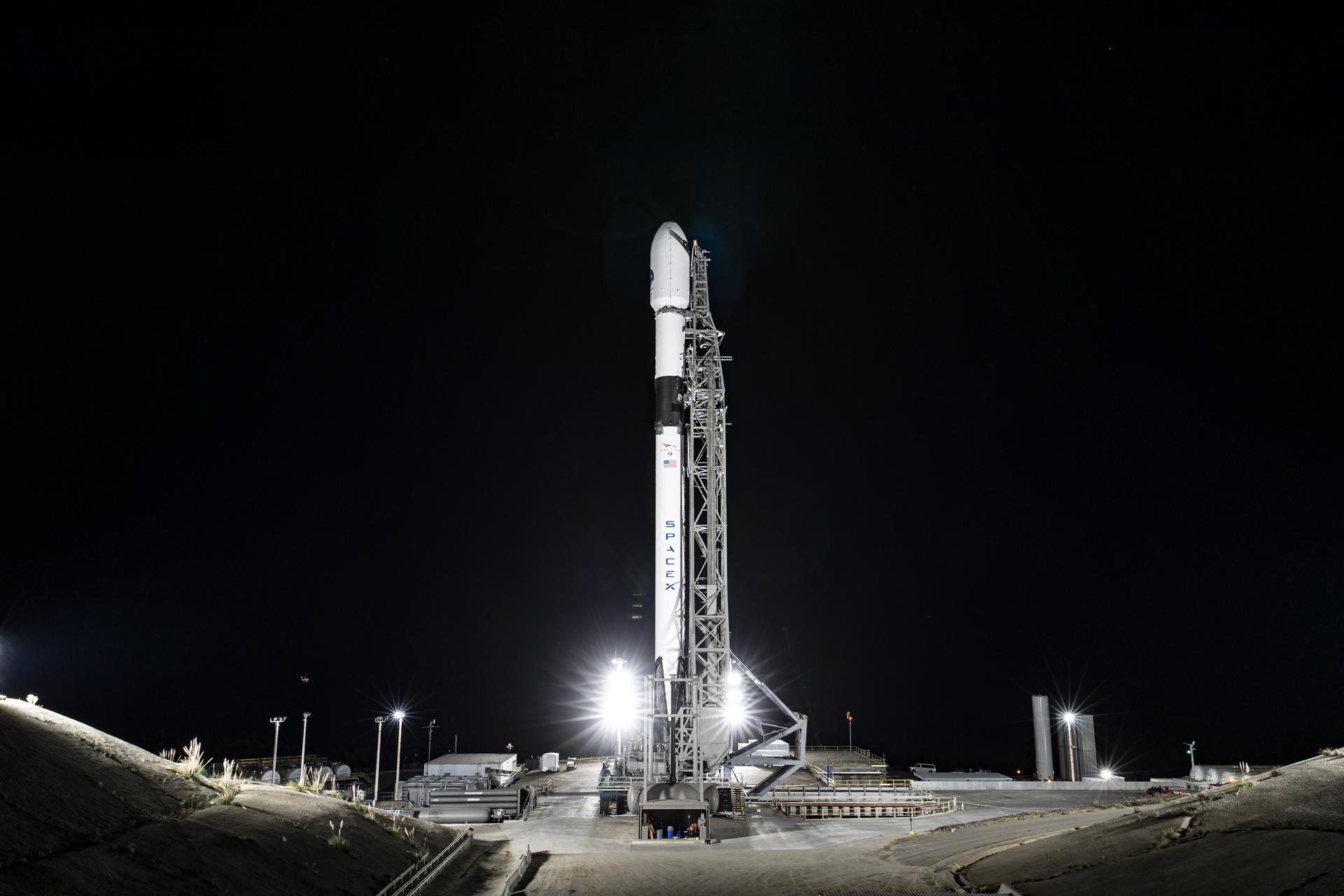
Set to track sea levels across more than 90% of Earth’s ocean, the mission must first get into orbit. Here’s what to expect.
Sentinel-6B, an ocean-tracking satellite jointly developed by NASA and ESA (European Space Agency), is ready to roll out to the launch pad, packed into the payload fairing of a SpaceX Falcon 9 rocket.
Launch is targeted at 12:21 a.m. EST, Monday, Nov. 17 (9:21 p.m. PST, Sunday, Nov. 16). Once it lifts off from Vandenberg Space Force Base in California, the satellite will ride out a 57-minute sequence of events ending in spacecraft separation, when the satellite detaches from the rocket.
Then Sentinel-6B’s real work begins. Orbiting Earth every 112 minutes at 4.5 miles (7.2 kilometers) per second, the satellite will eventually take over for its twin, Sentinel-6 Michael Freilich, launched five years ago, to continue a multidecade dataset for sea level measurements from space. Those measurements, along with atmospheric data the mission gathers, will help improve public safety and city planning while protecting coastal infrastructure, including power plants and defense interests. NASA will also use the data to refine atmospheric models that support the safe re-entry of Artemis astronauts.
Get the Sentinel-6B Press KitHere’s a closer look at what lies ahead for the satellite in the coming days.
Launch timelineMeasuring 19.1 feet (5.82 meters) long and 7.74 feet (2.36 meters) high (including the communications antennas), the satellite weighs in at around 2,600 pounds (1,200 kilograms) when loaded with propellant at launch.
The satellite will lift off from Space Launch Complex 4 East at Vandenberg. If needed, backup launch opportunities are available on subsequent days, with the 20-second launch window occurring about 12 to 13 minutes earlier each day.
A little more than two minutes after the Falcon 9 rocket lifts off, the main engine cuts off. Shortly after, the rocket’s first and second stages separate, followed by second-stage engine start. The reusable Falcon 9 first stage then begins its automated boost-back burn to the launch site for a powered landing. About three minutes after launch, the two halves of the payload fairing, which protected the satellite as it traveled through the atmosphere, separate and fall safely back to Earth.
The first cutoff of the second stage engine takes place approximately eight minutes after liftoff, at which point the launch vehicle and the spacecraft will be in a temporary “parking” orbit. The second stage engine fires a second time about 44 minutes later, and about 57 minutes after liftoff, the rocket and the spacecraft separate. Roughly seven minutes after that, the satellite’s solar panels deploy. Sentinel-6B is expected to make first contact with ground controllers about 35 minutes after separation (roughly an hour and a half after liftoff) — a major milestone indicating that the spacecraft is healthy.
Science missionFollowing launch operations, the team will focus on its next challenge: getting the spacecraft ready for science operations. Once in orbit, Sentinel-6B will fly about 30 seconds behind its twin, the Sentinel-6 Michael Freilich satellite. When scientists and engineers have completed cross-calibrating the data collected by the two spacecraft, Sentinel-6B will take over the role of providing primary sea level measurements while Sentinel-6 Michael Freilich will move into a different orbit. From there, researchers plan to use measurements from Sentinel-6 Michael Freilich for different purposes, including helping to map seafloor features (variations in sea surface height can reveal variations in ocean floor features, such as seamounts).
Sentinel-6B is part of a U.S.-European mission that will continue 30-year-plus record of sea-level measurements. Its observations will help build an accurate picture of local and global sea surface heights to support storm forecasting, secure coastal infrastructure, and help optimize commercial activities, such as shipping.NASA/JPL-Caltech Where to find launch coverage
Launch day coverage of the mission will be available on the agency’s website, including links to live streaming and blog updates beginning no earlier than 11 p.m. EST, Nov. 16, as the countdown milestones occur. Streaming video and photos of the launch will be accessible on demand shortly after liftoff. Follow countdown coverage on NASA’s Sentinel-6B blog.
For more information about NASA’s live programming schedule, visit
plus.nasa.gov/scheduled-events.
The Copernicus Sentinel-6/Jason-CS (Continuity of Service) mission is a collaboration between NASA, ESA, EUMETSAT (European Organisation for the Exploitation of Meteorological Satellites), and the National Oceanic and Atmospheric Administration (NOAA). The European Commission contributed funding support while France’s space agency CNES (Centre National d’Études Spatiales) provided technical expertise. The mission also marks the first international involvement in Copernicus, the European Union’s Earth Observation Programme.
A division of Caltech in Pasadena, JPL built three science instruments for each Sentinel-6 satellite: the Advanced Microwave Radiometer, the Global Navigation Satellite System – Radio Occultation, and the Laser Retroreflector Array. NASA is also contributing launch services, ground systems supporting operation of the NASA science instruments, the science data processors for two of these instruments, and support for the U.S. members of the international Ocean Surface Topography and Sentinel-6 science teams. The launch service is managed by NASA’s Launch Services Program, based at the agency’s Kennedy Space Center in Florida.
How Sentinel-6B Will Help Ships at Sea How Sentinel-6B Will Help Improve Hurricane Forecasts How Do We Measure Sea Level?News Media Contacts
Elizabeth Vlock
NASA Headquarters, Washington
202-358-1600
elizabeth.a.vlock@nasa.gov
Andrew Wang / Andrew Good
Jet Propulsion Laboratory, Pasadena, Calif.
626-379-6874 / 626-840-4291
andrew.wang@jpl.nasa.gov / andrew.c.good@jpl.nasa.gov
2025-125
Share Details Last Updated Nov 15, 2025 Related Terms Explore More 6 min read 6 Things to Know From NASA About New US, European Sea Satellite Article 3 days ago 1 min read Inside the Visualization: AerosolsNASA uses satellites, ground measurements, and powerful computer models to track tiny particles floating in…
Article 2 months ago 4 min read NASA Aircraft Coordinate Science Flights to Measure Air QualityMagic is in the air. No wait… MAGEQ is in the air, featuring scientists from…
Article 2 months ago Keep Exploring Discover Related Topics Explore Earth ScienceFrom its origins, NASA has studied our planet in novel ways, using a fleet of satellites and ambitious airborne and ground-based…
Earth Science at WorkNASA Earth Science helps Americans respond to challenges and societal needs — such as wildland fires, hurricanes, and water supplies…
Earth Science Data
Earth Science MissionsIn order to study the Earth as a whole system and understand how it is changing, NASA develops and supports…