
Feed aggregator
Britain's economy thrived after the withdrawal of the Roman Empire
Britain's economy thrived after the withdrawal of the Roman Empire
Deflecting a deadly asteroid just got a lot less dangerous
Deflecting a deadly asteroid just got a lot less dangerous
Watch Russia launch 2.8 tons of cargo toward the ISS today
NASA Uses Colorado Mountains for Simulated Artemis Moon Landing Course
NASA has certified a new lander flight training course using helicopters, marking a key milestone in crew training for Artemis missions to the Moon. Through Artemis, NASA will explore the lunar South Pole, paving the way for human exploration farther into the solar system, including Mars.
The mountains in northern Colorado offer similar visual illusions and flight environments to the Moon. NASA partnered with the Colorado Army National Guard at the High-Altitude Army National Guard Aviation Training Site near Gypsum, Colorado, to develop the foundational flight training course.
“Artemis astronauts who will land on the Moon will need to master crew coordination and communication with one another,” said Paul Felker, acting deputy director of flight operations at NASA’s Johnson Space Center in Houston. “Much like they will on the Moon, astronaut teams are learning how to work together efficiently in a stressful environment to identify hazards, overcome degraded visual environments, and evaluate risks to successfully land.”
During the two-week certification run in late August, NASA astronauts Mark Vande Hei and Matthew Dominick participated in flight and landing training to help certify the course. The pair took turns flying a helicopter and navigating to landing zones. Artemis flight crew trainers, mission control leads, and lunar lander operational experts from NASA Johnson joined them on each helicopter flight to assess the instruction, training environment, and technical applications for crewed lunar missions.
NASA astronauts Matthew Dominick (left) and Mark Vande Hei (right) prepare to fly out to a landing zone in the Rocky Mountains as part of the certification run for the NASA Artemis course at the High-Altitude Army National Guard Aviation Training Site in Gypsum, Colorado, Aug. 26. NASA/Michael DeMocker A LUH-72 Lakota helicopter stirs up dust at the High-Altitude Army National Guard Aviation Training Site in Gypsum, Colorado, Aug. 28. NASA/Charles Beason A member of the Colorado Army National Guard peers out of a CH-47 Chinook in preparation for landing Aug. 22. NASA and trained instructors from the Army National Guard use a range of aircraft during flight training. Chinooks are used to demonstrate challenges with landing on the Moon. NASA/Charles Beason NASA astronauts Matthew Dominick (left) and Mark Vande Hei (right) celebrate after returning from a training flight Aug. 26 during a certification run for a lander flight training course for crewed Artemis missions. NASA/Michael DeMocker Paired with trained instructors with the Army National Guard, astronauts fly to mountaintops and valleys in a range of aircraft, including LUH-72 Lakotas, CH-47 Chinooks, and UH-60 Black Hawks. NASA/Charles Beason NASA astronaut Mark Vande Hei lands a helicopter as part of flight and landing training at the High Altitude Army National Guard Aviation Training Site Aug. 28. NASA/Michael DeMocker A member of the Colorado Army National Guard looks out of a CH-47 Chinook as it lands at a steep angle Aug. 29. A crater on the Moon could have a similar incline, posing landing challenges for future crewed Artemis missions. NASA/Michael DeMocker A LUH-72 Lakota helicopter flies over the mountains of northern Colorado Aug. 28 during a certification run for a lander flight training course for crewed Artemis missions. The mountains and valleys in Colorado have similar visual illusions to the Moon. NASA/Michael DeMocker The patch for the High-Altitude Army National Guard Aviation Training Site is pictured in the cupola of the International Space Station in 2023. NASA and the Colorado Army National Guard began working together in 2021 to develop a foundational lunar lander simulated flight training course for Artemis. NASAThe NASA astronauts and trained instructor pilots with the Army National Guard flew to progressively more challenging landing zones throughout the course, navigating the mountainous terrain, and working together to quickly and efficiently land the aircraft.
Teams can train year-round using the course. Depending on the season, the snowy or dusty conditions can cause visual obstruction. Lunar dust can cause similar visual impairment during future crewed missions.
“Here in Colorado, we have specifically flown to dusty areas, so we know and understand just how important dust becomes during the final descent phase,” Vande Hei said. “Dust will interact with the lander thrusters on the Moon. During our flight training, we have had to revert to our instruments – just like we would on the Moon – because astronauts may lose all their visual cues when they’re near the surface.”
During Artemis III, four astronauts inside the agency’s Orion spacecraft on top of the SLS (Space Launch System rocket) will launch to meet SpaceX’s Starship Human Landing System in lunar orbit. Orion will then dock with the Starship system and two astronauts will board the lander. Astronauts will use the Starship lander to safely transport themselves from lunar orbit to the lunar surface. Following surface operations, the two astronauts will use Starship to launch from the lunar surface, back to lunar orbit, and dock with Orion to safely journey back to Earth.
The NASA-focused course has been in development since 2021. Vande Hei and Dominick are the 24th and 25th NASA astronauts to participate in and evaluate the course based on functionality and Artemis mission needs. One ESA (European Space Agency) astronaut has also participated in the course.
“This course will likely be one of the first group flight training opportunities for the Artemis III crew,” said NASA astronaut Doug Wheelock, who helped to develop the foundational training course for the agency. “While the astronauts will also participate in ground and simulation training in Ohio and Texas, the real-world flight environment in Colorado at HAATS offers astronauts an amazing simulation of the problem solving and decision making needed to control and maneuver a lunar lander across an equally dynamic landscape.”
Though the course is now certified for Artemis, teams will continue to evaluate the training based on astronaut and technical feedback to ensure mission success and crew safety.
Through the Artemis campaign, NASA will send astronauts to explore the Moon for scientific discovery, economic benefits, and to build the foundation for the first crewed missions to Mars for the benefit of all.
For more information about Artemis visit:
Share Details Last Updated Sep 11, 2025 EditorBeth RidgewayContactCorinne M. Beckingercorinne.m.beckinger@nasa.govLocationMarshall Space Flight Center Related Terms Explore More 9 min read Artemis II Crew Both Subjects and Scientists in NASA Deep Space Research Article 7 hours ago 5 min read NASA’s Northrop Grumman CRS-23 Infographics & Hardware Article 7 hours ago 3 min read NASA Launches 2026 Lunabotics Challenge Article 3 days ago Keep Exploring Discover More Topics From NASAArtemis
Human Landing System
Artemis III
Humans In Space
SpaceX buys $17 billion worth of satellite spectrum to beef up Starlink broadband service
The Murchison Widefield Array Just Doubled In Size - What Could It Find Now?
Radio astronomy took another step forward recently, with the completion of Phase III of the Murchison Widefield Array (MWA) in Western Australia. We’ve reported before on how the MWA has investigated everything from SETI signals to the light from the earliest stars. WIth this upgrade, the MWA will continue to operate with much needed improvements while the radio astronomy awaits the completion of the successor it helped enable - the Square Kilometer Array (SKA).
Juno Detects Callisto's "Footprints" in Jupiter's Aurorae
Jupiter hosts the brightest and most spectacular auroras in the Solar System, and its largest moons (the Galileans) create their own auroral signatures known as “satellite footprints” in the planet’s atmosphere. Until now, astronomers had detected the auroral signatures of three Galileans (Io, Europa, and Ganymede), but not Callisto. Thanks to an international team, close-up images of Callisto's footprints have been seen at last.
The JWST's New Contribution To Understanding The Cosmic Dawn: MINERVA
The JWST is performing a new multi-wavelength survey called MINERVA (Medium-band Imaging with NIRCam to Explore ReVolutionary Astrophysics). It'll study four extragalactic fields in greater detail and depth, and will help us understand the Cosmic Dawn.
Clues In A Dusty Disk Point The Way To A Potential Exoplanet
Astronomers struggle to detect small exoplanets directly. One tool they use is to search for the effects these planets have on debris disks around stars. Clues in these disks tell astronomers where they can find sub-Jupiter mass exoplanets.
The Earth Observer Editor’s Corner: July–September 2025
13 min read
The Earth Observer Editor’s Corner: July–September 2025
NOTE TO READERS: After more than three decades associated with or directly employed by NASA, Steve Platnick [GSFC—Deputy Director for Atmospheres, Earth Sciences Division] stepped down effective August 8, 2025. Steve began his civil servant career at GSFC in 2002, but his GSFC association went back to 1993, first as a contractor and then as one of the earliest employees of the Joint Center for Earth Systems Technology (JCET). During his time at NASA, Steve played an integral role in the sustainability and advancement of NASA’s Earth Observing System platforms and data. He was actively involved in the Moderate Resolution Imaging Spectroradiometer (MODIS) Science Team, where he helped advance several key components of the MODIS instrument. He was also the NASA Lead/co-Lead for the Suomi National Polar-orbiting Partnership (Suomi NPP), Atmosphere Discipline from 2012–2020 where he focused on operational cloud optical and microphysical products.
In 2008, Steve became the Earth Observing System (EOS) Senior Project Scientist. In this role, he led the EOS Project Science Office that supported airborne sensors, ground networks, and calibration labs. The Kudos article titled “Steve Platnick Steps Down from NASA After 34 Years of Service” includes a more detailed account of Steve’s career and includes a list of awards he has received.
Steve’s departure leaves a vacancy in the author’s chair for “The Editor’s Corner” – another role Steve filled as EOS Senior Project Scientist. Barry Lefer [NASA Headquarters—Associate Director of Research, Earth Science Division] graciously agreed to serve as guest author of the editorial in the current compilation. I want to thank Steve for all his support for The Earth Observer over the years and thank Barry for stepping in as the author of “The Editor’s Corner” for the time being.
–Alan Ward, Executive Editor, The Earth Observer
I begin this editorial with news of a successful Earth science launch. At 5:40 PM Indian Standard Time (IST), or 8:10 AM Eastern Daylight Time (EDT), on July 30, 2025, the joint NASA–Indian Space Research Organization (ISRO) Synthetic Aperture Radar, or NISAR, mission launched from the Satish Dhawan Space Centre on India’s southeastern coast aboard an ISRO Geosynchronous Satellite Launch Vehicle (GSLV) rocket 5. The ISRO ground controllers began communicating with NISAR about 20 minutes after launch, at just after 8:29 AM EDT, and confirmed it is operating as expected.
NISAR will use two different radar frequencies (L-band SAR and S-band SAR) to penetrate clouds and forest canopies. Including L-band and S-band radars on one satellite is an evolution in SAR airborne and space-based missions that, for NASA, started in 1978 with the launch of Seasat. In 2012, ISRO began launching SAR missions starting with Radar Imaging Satellite (RISAT-1), followed by RISAT-1A in 2022, to support a wide range of applications in India.
Combining the data from these two radars will allow researchers to systematically and globally map Earth – measuring changes of our planet’s surface down to a centimeter (~0.4 inches). With this detailed view, researchers will have an unprecedented ability to observe and measure complex processes from ecosystem disturbances to natural hazards to groundwater issues. All NISAR science data will be freely available and open to the public.
Following the successful launch, NISAR entered an approximately 90-day commissioning phase to test out systems before science operations begin. A key milestone of that phase was the completion of the deployment of the 39-ft (12-m) radar antenna reflector on August 15 – see Video. The process began on August 9, when the satellite’s boom, which had been tucked close to its main body, started unfolding one joint at a time until it was fully extended about four days later. The reflector assembly is mounted at the end of the boom. On August 15, small explosive bolts that held the reflector assembly in place were fired, enabling the antenna to begin a process called the bloom – its unfurling by the release of tension stored in its flexible frame while stowed like an umbrella. Subsequent activation of motors and cables pulled the antenna into its final, locked position.
Video: NISAR mission team members at NASA JPL, working with colleagues in India, executed the deployment of the satellite’s radar antenna reflector on Aug. 15, 2025. About 39 feet (12 meters) in diameter, the reflector directs microwave pulses from NISAR’s two radars toward Earth and receives the return signals. Credit: NASA/JPL-CaltechThe radar reflector will be used to direct and receive microwave signals from the two radars. By interpreting the differences between the L-band and S-band measurements, researchers will be able to discern characteristics about the surface below. As NISAR passes over the same locations twice every 12 days, scientists can evaluate how those characteristics have changed over time to reveal new insights about Earth’s dynamic surfaces.
With the radar reflector now in full bloom, scientists have turned their attention to tuning and testing the radar and preparing NISAR for Science Operations, which are anticipated to start around the beginning of November. Congratulations to the NISAR team on a successful launch and deployment of the radar reflector. Along with the science community, I am excited to see what new discoveries will result from the data collected by the first Earth System Observatory mission.
Turning now to news from active missions, the Soil Moisture Active Passive (SMAP) mission has collected over 10 years of global L-band radiometry observations that have resulted in surface soil moisture, vegetation optical depth (VOD), and freeze/thaw state estimates that outperform past and current products. A decade of SMAP soil moisture observations has led to scientific achievements, including quantifying the linkages of the three main metabolic cycles (e.g., carbon, water, and energy) on land. The data have been widely used by the Earth system science community to improve drought assessments and flood prediction as well as the accuracy of numerical weather prediction models.
SMAP’s Early Adopter program has helped connect SMAP data with people and organizations that need it. The program has increased the awareness of SMAP mission products, broadened the user community, increased collaboration with potential users, improved knowledge of SMAP data product capabilities, and expedited the distribution and uses of mission products for a suite of 16 products available. For example, the L-band VOD, which is related to water content in vegetation, is being used to better understand water exchanges in the soil–vegetation–atmosphere continuum.
The SMAP Active–Passive (AP) algorithm – based on data from SMAP and the European Copernicus Program Sentinel-1 C-band synthetic aperture radar (SAR) – will be adapted to work with L-band data from the newly launched NISAR mission. The result will be estimates of global soil moisture at a spatial resolution of 1 km (0.62 mi) or better approximately once per week.
In addition, the data collected during the SMAP mission would be continued and further enhanced by the European Union’s Copernicus Imaging Microwave Radiometer (CIMR) mission if it launches. This proposed multichannel microwave radiometry observatory includes L-band and four other microwave channels sharing a large mesh reflector – like the one used with SMAP. The plan calls for CIMR to follow a similar approach as SMAP for RFI detection and meet the instrument thermal noise and data latency of SMAP for next-mission desired characteristics.
To learn more about what SMAP has accomplished see “A Decade of Global Water Cycle Monitoring: NASA Soil Moisture Active Passive Mission.”
NASA’s Orbiting Carbon Observatory-2 (OCO-2) has been the “gold standard” for atmospheric carbon dioxide (CO2) observations from space for over a decade. The data returned from OCO-2 provide insights into plant health, forest management, forecasting crop yields, fire-risk models, and anticipating droughts.
OCO-3, constructed from spare parts left after OCO-2, was launched to the International Space Station (ISS) in 2019, where it has operated for over five years. OCO-3 extends the global CO2 measurement record while adding new capabilities made possible by being on ISS (e.g., detailed views of urban and tropical regions).
The overarching OCO mission hasn’t just about been about data and hardware. Although both those elements are parts of the story, the human stories woven through the mission’s successes and setbacks are really what holds the mission together. The feature, “A Tapestry of Tales: 10th Anniversary Reflections from NASA’s OCO-2 Mission,” sheds light on some of these personal stories from the OCO-2 and OCO-3 missions.
The individual tales contained in this article reveal the grit and determination behind the scenes of the success of OCO-2 and OCO-3, from the anxiety and excitement surrounding the launch of OCO-2, to moments of fieldwork in the Nevada desert, to internships where wildfire responders turned to OCO-2 data to improve fire-risk models. Taken together, these stories form a “tapestry” that reveals how the OCO-2 and OCO-3 missions continue to illuminate the dynamics of Earth’s atmosphere – one breath at a time.
These personal perspectives underscore that science is not just numbers; it’s people pushing boundaries, navigating failure, and inspiring ways to make our planet safer and healthier. In a time such as this, this is an important reminder.
The joint NASA–U.S. Geological Survey (USGS) Landsat program has been a cornerstone of Earth observation for over 50 years. On July 13, Landsat 9 collected its millionth image: a stunning shot of the Arctic National Wildlife Refuge in Alaska – see Figure. Landsat 9, the most recent satellite in the Landsat series, orbits Earth alongside Landsat 8. Together, these satellites collect invaluable data about Earth’s changing land surface every eight days.
Figure: This Landsat 9 image showing the Beaufort Sea shoreline off Alaska and Canada is just one of the scenes captured and processed on July 13, 2025— the same day the USGS EROS archive reached a milestone of one million Landsat 9 Level-1 products. This false color image was made with bands 6, 5, and 4 from the Operational Land Imager. This remote area allows the pristine wilderness environment to support a diverse wildlife and unique ecosystem that includes various species of mammals, birds, and fish. Landsat Level-1 products from Landsat 1 through Landsat 9 can be downloaded at no charge from a number of systems – visit the Landsat Data Access webpage to learn more. Credit: Public Domain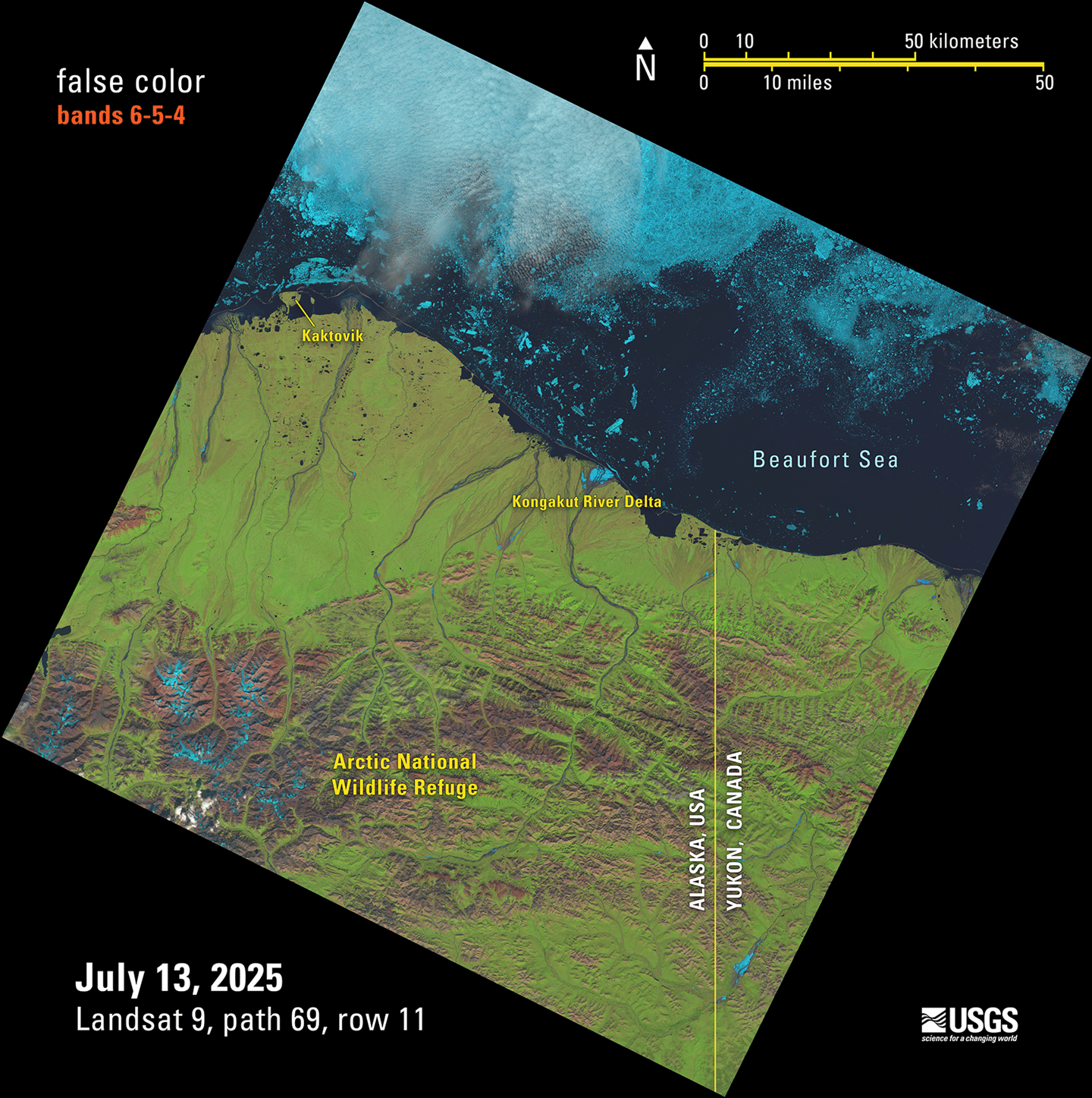
After collecting more than 3.3 million images over the course of more than 26 years in orbit, Landsat 7 was decommissioned on June 4, 2025. A YouTube video released at the time of decommissioning provides a concise visual summary of the Landsat 7 mission’s achievements – and the technical challenges overcome. In addition, The Earth Observer did a feature for the 20th anniversary of Landsat 7 in the July–August 2019 issue, called “The Living Legacy of Landsat 7: Still Going Strong After 20 Years in Orbit” [Volume 31, Issue 4, pp. 4–14] that is a useful resource to learn more about the history and achievements (through 20 years) of the mission.
One of the strengths of the Landsat program is its potential for data integration with other satellites. The Harmonized Landsat and Sentinel-2 (HLS) product exemplifies this collaborative approach by combining data from Landsat 8 and 9 with data from the European Space Agency’s Copernicus Sentinel-2 A, B, and C missions. Whereas Landsat alone has a repeat time of eight days (i.e., combining Landsat 8 and 9 data); the combined HLS dataset provides imagery for the same location on Earth every 1.6 days – enabling researchers to monitor short-term changes in Earth’s land surface much more effectively than using Landsat or Sentinel-2 data alone.
HLS became one of the most-downloaded NASA data products in fiscal year 2024, with continued growth on the horizon. In February 2025, the program expanded with nine new vegetation indices based on HLS data, with historical processing back to 2013 scheduled for completion by early 2026. Low-latency HLS products will also be available in late 2026. For the full story of how HLS came to be – see the feature: “Harmonized Landsat and Sentinel-2: Collaboration Drives Innovation.”
Following a 13-month hibernation, the Global Ecosystem Dynamics Investigation (GEDI) mission was reinstalled to its original location aboard the ISS and resumed operations on April 22, 2024. Since this storage period, GEDI’s lasers have been operating nominally and the mission has continued to produce high-quality observations of the Earth’s three-dimensional structure, amassing 33 billion land surface returns as of November 27, 2024.
The mission team has been actively processing and releasing post-storage data to the public, with Version 2.1 – GEDI L1B, L2A, L2B, and L4A data products, which include data through November 2024, all available for download. The new L4C footprint-level Waveform Structural Complexity Index (WSCI) product using pre-storage data has also been released. Looking ahead, the team is preparing Version 3.0 (V3) of all data products, which will incorporate post-storage data while improving quality filtering, geolocation accuracy, and algorithm performance.
The 2025 GEDI Science Team Meeting (STM) brought together the mission science team, competed science team, representatives from the distributed active archive centers (DAACs), collaborators, stakeholders, and data users. Notably, it marked the first in-person gathering of the second competed science team, who shared updates on their research projects. The STM held an important space for brainstorming, knowledge-sharing, and discussion as the GEDI mission continues to flourish in its second epoch. To learn more, see “Summary of the 2025 GEDI Science Team Meeting.”
Shifting focus to the boreal forests of North America, the NASA Arctic–Boreal Vulnerability Experiment (ABoVE) is now in its final year, marking the end of a decade-long scientific endeavor that has transformed our understanding of environmental change in Alaska and western Canada. This ambitious campaign, funded primarily by NASA’s Terrestrial Ecology Program, has successfully progressed through three distinct phases: ecosystem dynamics (2015–2018), ecosystem services (2017–2022), and the current analysis and synthesis phase (2023–present).
As ABoVE approaches its conclusion, the program has grown to encompass 67 NASA-funded projects with over 1000 participating researchers – a testament to the collaborative scale required to address complex Arctic–boreal ecosystem questions. The program’s integrated approach, combining field research, airborne campaigns, and satellite remote sensing, has generated unprecedented insights into how environmental changes in these northern regions affect both vulnerable ecosystems and society.
The recent 11th – and final – ABoVE Science Team Meeting was an opportunity to showcase the program’s evolution from data collection to synthesis, highlighting successful community engagement initiatives, cutting-edge research on carbon dynamics and ecosystem responses, and innovative science communication strategies that have made this complex research accessible to diverse audiences. With synthesis activities now underway, ABoVE is positioned to deliver comprehensive insights that will inform Arctic and boreal research for years to come. To learn more, see “Summary of the 11th and Final ABoVE Science Team Meeting.”
Last but certainly not least, I want to both recognize and congratulate Compton J. Tucker [GSFC—Senior Researcher]. Compton retired from NASA in March 2025 after 48 years of public service, and then in April, was among 149 newly elected members to the National Academy of Sciences (NAS) – which is one of the highest honors in American science. This recognition from NAS brings Compton’s career full circle. He came to GSFC as a NAS postdoc before joining NASA as a civil servant. Compton is a pioneer in the field of satellite-based environmental analysis, using data from various Landsat missions and from the National Oceanographic and Atmospheric Administration’s (NOAA) Advanced Very High Resolution Radiometer (AVHRR) instrument. His research has focused on global photosynthesis on land, determining land cover, monitoring droughts and food security, and evaluating ecologically coupled disease outbreaks. The Kudos, “Compton J. Tucker Retires from NASA and is Named NAS Fellow,” provides more details about Compton’s research achievements and all of the other scientific awards and honors received throughout his career.
Barry Lefer
Associate Director of Research, Earth Science Division