
NASA - Breaking News
Join Second Lady Usha Vance as She Reads to Children at NASA Johnson
As part of her Summer Reading Challenge, Second Lady Usha Vance will host an event for children in grades K-8 on Monday, Aug. 4, at NASA’s Johnson Space Center in Houston. Media are invited.
NASA astronaut Suni Williams will join Ms. Vance to read a space-related book to children and participate in other space-related activities.
Live coverage of the reading will stream about 2:45 p.m. EDT on NASA+. Learn how to watch NASA content through a variety of platforms, including social media.
U.S. media interested in participating in this event must RSVP to NASA Press Secretary Bethany Stevens at: bethany.c.stevens@nasa.gov, as well as Office of the Second Lady Communications Director Nicole Reeves at: nicole.e.reeves@ovp.eop.gov. Requests must be made no later than 1 p.m. EDT on Thursday, July 31. Confirmed media will receive additional details from NASA. The agency’s media accreditation policy is online.
Through her reading challenge, the Second Lady is encouraging youth to seek adventure, imagination, and discovery between the pages of a book. Students interested in participating in the challenge must read 12 books by Friday, Sept. 5. Additional details, including where to download a reading log, and how to submit it to the White House, are available online.
As part of NASA’s Artemis campaign, the agency will send astronauts to the Moon to prepare for future human exploration of Mars, inspiring Golden Age explorers, and ensuring the United States continues to lead in space exploration and discovery.
Learn more about NASA missions online at:
-end-
Bethany Stevens / Cheryl Warner
Headquarters, Washington
202-358-1600
bethany.c.stevens@nasa.gov / cheryl.m.warner@nasa.gov
Ames Exchange Lodging Info
If you’re visiting Ames for an extended period, you’ll need lodging that’s in the area, and affordable. This article will go over the lodging options that we have on-center.
Who May Stay?
Personnel in the following categories are considered eligible:
- APPEL course participants
- ARC college student program participants
- TDY visitors to NASA or other federal agencies on official orders
- Visiting university faculty, post-doctoral students (to NASA only)
- Visitors to ARC or other federal agency on-site contractors to conduct NASA or resident agency related business
- Active duty or reserve-on-active-duty military with orders
- ARC employees conducting business facilitated by overnight accommodation (e.g. ongoing experiment, major conference)
- ARC employees for their personal convenience
- NASA and military service retirees
- Accompanying family members of the above
- NRP Tenants and their guests (foreign nationals must be cleared through security prior to NRP and lodge access)
Making A Reservation
Please contact the front desk for all inquiries.
Business Hours: Monday – Friday, 8:30am – 4:00pm
Phone: (650) 604-8100
Email: info@nasalodge.com
Check-In: 3:00 PM (Contactless check-in is available after business hours.)
Check-Out: 11:00 AM
All reservations require an email address and a cell phone number. Credit card information is required prior to check-in by calling the front desk. Cancellations or changes must be done at least 24 hours prior to check-in via email at info@nasalodge.com or calling the front desk at (650) 604-8100. If you fail to cancel your reservation, you will be charged for one night’s stay.
Building 19 Premium King Room
- 24 Remodeled Modern Rooms
- Luxurious Restroom with Walk-in Shower & Towel Warmers
- Central A/C & Heating
- Spacious Closet Space
- Work Desk Space
- Mini Refrigerator with Freezer
- Flat Screen TV with Full DirecTV Access Including HBO, Showtime, Cinemax, Etc.
- In-Room Safe
- Complimentary Coffee & Bottled Water
- Iron & Ironing Board
- Robust Power Outlets USB-A & USB-C
- Dimmable Lighting
- Keyless RFID Entry
- NASA-Connect Accessible
- Free Parking
- Complimentary Breakfast
Building 19- Standard Queen Room
- 20 Remodeled Queen Rooms
- A/C Window Unit
- Heater Unit
- Work Desk Space
- Private Bathroom
- Mini Refrigerator with freezer
- Flatscreen TV
- In-Room Safe
- Iron & Iron Board
- NASA-Connect Accessible
- Free Parking
- Complimentary Breakfast
Buildings 583 A & B Dorms
- Queen & Twin Size Bed Options
- Work Desk Space
- Private Restroom
- Microwave
- Refrigerator with Freezer (Size varies)
- Access Communal Kitchen
- NASA-Connect Accessible
- Flatscreen TV Available in Select Rooms
Silicon Valley Event Center – Parking Information
At the main Event Center in building 3, at the front of the building (East side) there is a large lot with standard and accessible spaces. This is the best place to park as it affords the easiest access to the entry doors, which have an ADA accessible ramp. At the rear of the building, there is a secondary large over-flow lot. As this is on the back side of the building, you will need to walk all the way around to enter through the main entrance, or make arrangements to enter through the ADA accessible doors at the rear of the building.
Inside the NASA security fence, at building N232 and the N201 Syverston Auditorium, there is very little parking available and it is first-come first-serve. We highly recommend walking or carpooling to these locations if you are attending an event in either of them
Please keep in mind that if you are driving in, the driver will need a valid, RealID, drivers license. In addition, everyone in the car must have a valid form of ID; Government issued RealID, valid passport, or other form of accepted identification.
Back to the SVEC HomeNASA Silicon Valley Event Center – Calendar of Events
Visiting the NASA Silicon Valley Event Center
Due to the nature of being a NASA facility, there are some special considerations that must be taken into account.
Traveling To & From
The Event Center is located on the publicly accessible side of the Ames campus. If you plan to arrive via ride share, please be aware that the vehicle and driver must have a valid RealID Drivers License and vehicle registration documents. All passengers will need valid ID as well.
U.S. Citizens must show a valid, officially-issued RealID at the NASA Research Park gate to enter onto the NASA Research Park, where the SVEC is located.
All Foreign Nationals must go through NASA badging procedures to attend meetings at the SVEC.
NASA Transfer Technology and Export Control
If you are having NASA speakers and Non-NASA attendees, your speakers must clear the information with the “NASA” Export Control Office.
NASA Selects Human Space Flight Technical Integration Contractor
NASA has selected Barrios Technology, LLC, in Houston to provide technical integration services for the agency’s human spaceflight programs.
The Mission Technical Integration Contract is a cost-plus-award-fee and cost-plus-incentive fee contract with core and indefinite-delivery/indefinite-quantity requirements. It has a total estimated value of approximately $450 million, and a period of performance beginning Oct. 1, and ending on Sept. 30, 2027, along with four one-year option periods through 2031.
Under the contract, the contractor will provide technical integration and related services for multiple human spaceflight programs. These services include program, business, configuration and data management, information technology, systems engineering and integration, mission integration, safety and mission assurance, and operations.
For information about the agency and its programs, visit:
-end-
Tiernan Doyle
Headquarters, Washington
202-358-1600
tiernan.doyle@nasa.gov
Curiosity Blog, Sols 4609–4610: Recharged and Ready To Roll Onwards
- Curiosity Home
- Science
- News and Features
- Multimedia
- Mars Missions
- Mars Home
3 min read
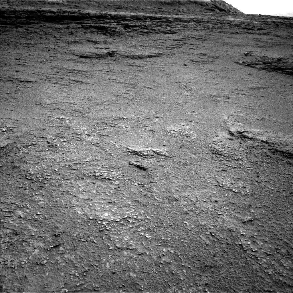
Curiosity Blog, Sols 4609–4610: Recharged and Ready To Roll Onwards NASA’s Mars rover Curiosity acquired this image showing the boxwork hollow where it is investigating, and the boxwork ridge on the far side of the hollow, using its Left Navigation Camera. Curiosity captured the image on July 20, 2025 — Sol 4605, or Martian day 4,605 of the Mars Science Laboratory mission — at 18:51:55 UTC.NASA/JPL-CaltechWritten by Catherine O’Connell-Cooper, Planetary Geologist at University of New Brunswick
Earth planning date: Wednesday, July 23, 2025
For today’s planning, we were in the same workspace as the Monday plan — on purpose! We don’t often have a plan without a drive but in order to allow the battery to recover from some power-hungry SAM atmospheric measurements over the weekend and on Monday, we needed to stay put and skip our usual drive. As a result, we gained a bonus planning cycle at this interesting workspace.
We are in one of the “hollows” between the resistant ridges of the “boxwork” terrain, as you can see in the image for this blog. This made for a quieter Operations day for me as the APXS planner. As Deborah noted in Monday’s blog, we have already gotten three APXS and MAHLI measurements in this workspace, so we didn’t acquire more in this plan.
This morning, we focused on documenting some small light-toned, rounded, white pebbles in the workspace (you can see them in the accompanying Navcam image), which look very different from the underlying bedrock. We used our one ChemCam LIBS analysis for the plan on “Yana Qaqa.” Mastcam will image this pebble, another at “Ojos del Salado,” and a really cool-looking target with a dendritic-looking texture at “Punta de Lobos.”
Further afield, Mastcam will image the adjacent boxwork ridge and hollow in our drive direction, and a series of troughs with raised edges to the right of our current workspace. ChemCam will image a long-distance RMI mosaic of “Cueva de los Vencejos y Murciélagos,” which was imaged by Mastcam on Monday, and also acquire some further images of the “Mishe Mokwa” hill.
We had a bumper couple of sols of atmospheric measurements over the weekend and Monday. Now we revert back to our more normal environmental and atmospheric monitoring. These do not get as much attention sometimes as the amazing images we take of the fascinating rocks we see, but have been taking place consistently and continuously since Curiosity’s landing almost 13 years ago now. This plan includes a series of Navcam movies (suprahorizon, dust devil) and a line-of-sight observation of dust, standard REMS and DAN observations, and two Mastcam tau measurements, looking at dust in the atmosphere.
Our 24-meter drive (almost 79 feet) will take us out of this hollow and back up on top of a ridge. From here, we hope to be able to spy the best driving path through the boxwork. The ridges are up to 5 meters in diameter (about 16 feet), so we are cautiously hopeful that we can just trundle along one of the ridges as we investigate this fascinating terrain.
For more Curiosity blog posts, visit MSL Mission Updates Learn more about Curiosity’s science instruments Share Details Last Updated Jul 28, 2025 Related Terms Explore More 2 min read Feeling the Heat: Perseverance Looks for Evidence of Contact Metamorphism Article 6 days ago 3 min read Curiosity Blog, Sols 4607-4608: Deep Dip Article 6 days ago 3 min read Curiosity Blog, Sols 4604-4606: Taking a Deep Breath of Martian Air Article 6 days ago Keep Exploring Discover More Topics From NASA MarsMars is the fourth planet from the Sun, and the seventh largest. It’s the only planet we know of inhabited…
All Mars ResourcesExplore this collection of Mars images, videos, resources, PDFs, and toolkits. Discover valuable content designed to inform, educate, and inspire,…
Rover BasicsEach robotic explorer sent to the Red Planet has its own unique capabilities driven by science. Many attributes of a…
Mars Exploration: Science GoalsThe key to understanding the past, present or future potential for life on Mars can be found in NASA’s four…
2025 NASA Space Apps Challenge
On October 4–5, 2025, NASA—along with 14 international space agency partners—invites scientists, engineers, coders, designers, storytellers, and space enthusiasts of all kinds to take part in the 2025 NASA International Space Apps Challenge. This two-day global hackathon brings together diverse teams to tackle real-world problems using NASA’s open data, alongside space-based data from agencies around the world.
This year’s theme, Learn, Launch, Lead, encourages participants to:
- Learn new skills and deepen their understanding of STEM,
- Launch bold ideas by transforming open data into actionable solutions, and
- Lead communities in pioneering innovation and discovery.
Participants will collaborate to develop creative, open-source projects that address Earth and space-related challenges. Whether you’re a seasoned developer, an aspiring student, or a creative thinker, there’s a place for you in this global movement.
Together, we’ll use the power of open data and global collaboration to solve some of the world’s toughest challenges—on Earth and beyond.
OSDR Chats with Begum Mathyk
Welcome to “OSDR Chats,” an interview series featuring authors of publications that were enabled by the Open Science Data Repository (OSDR). Researchers share highlights and insights into their work, emphasizing the valuable roles played by the OSDR in their research. This newest interview features Dr Begum Mathyk who discusses her paper “Spaceflight induces changes in gene expression profiles linked to insulin and estrogen“, one of 45 that were part of the Nature Press package publications.
Organismal adaptations to spaceflight have been characterized at the molecular level in model organisms, including Drosophila and C. elegans. This study extends such molecular work to energy metabolism and sex hormone signaling in mice and humans. The findings of this research underscore the critical importance of in-depth hormonal studies on the effects of space travel, which are vital for enabling further human exploration of space. The study also emphasizes the need for further research focused on women’s health and the development of tailored healthcare strategies for space environments.
OSDR recently spoke to Dr Mathyk to hear about the highlights of this publication and about how the OSDR and Analysis Working Groups (AWGs) enabled this publication.
Link to Publication; Link to Datasets: OSD-48, OSD-98, OSD-99, OSD-100, OSD-101, OSD-102, OSD-103, OSD-104, OSD-105, OSD-168, OSD-238, OSD-239, OSD-240, OSD-241, OSD-254, OSD-530; Learn more about Analysis Working Groups (AWGs); Request to Join Analysis Working Groups (AWGs)NASA Drop Test Supports Safer Air Taxi Design and Certification
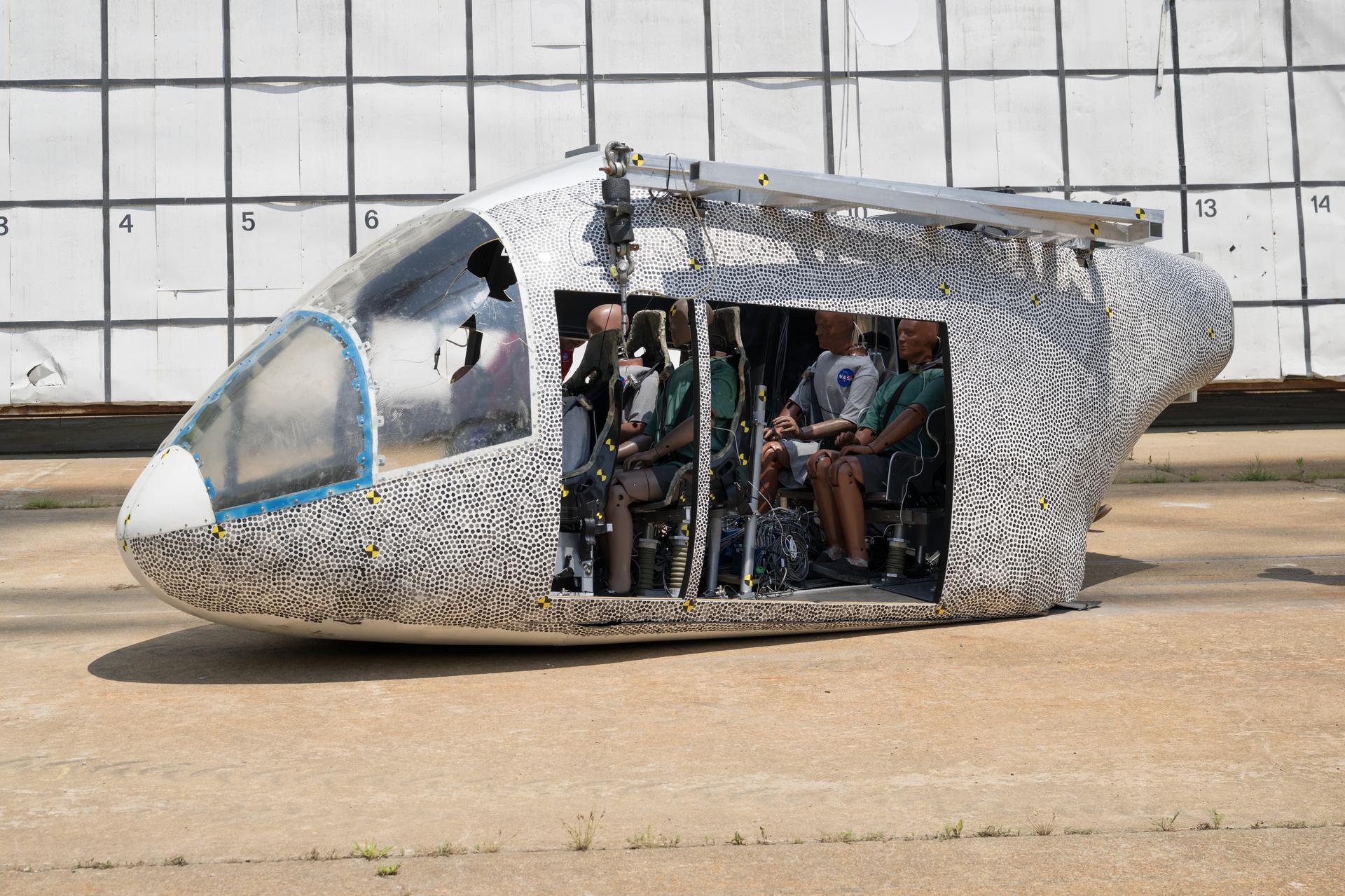
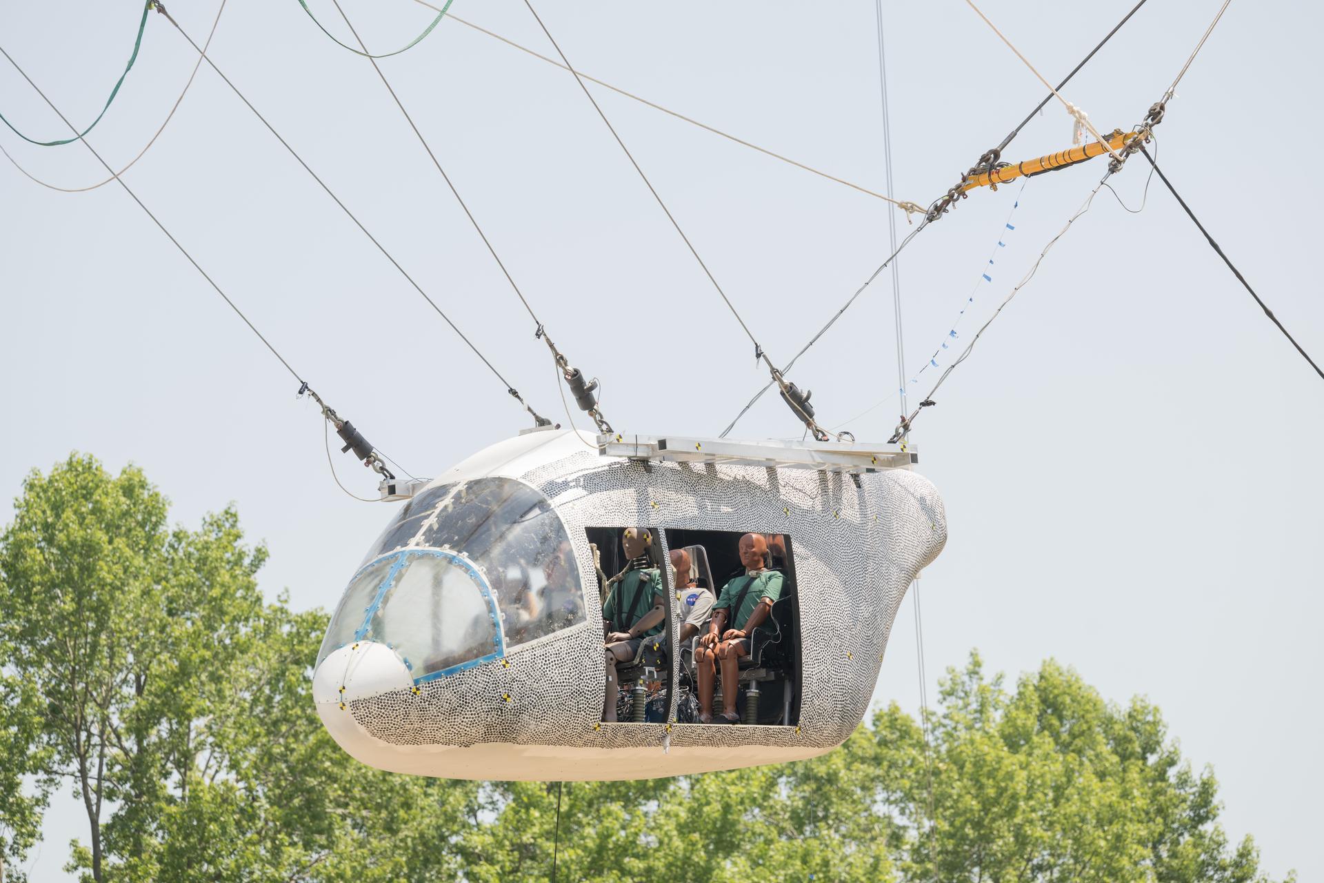
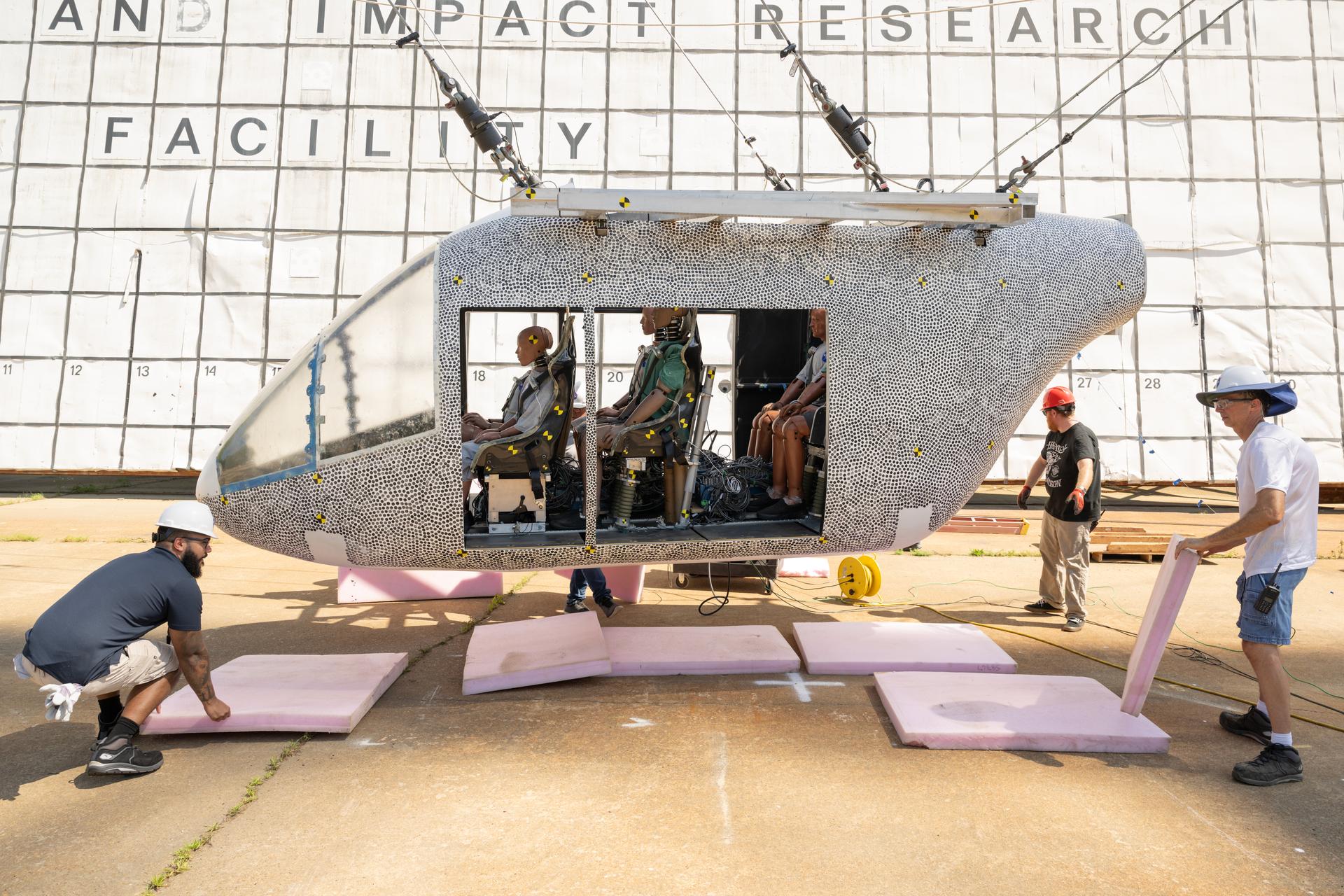
3 min read
Preparations for Next Moonwalk Simulations Underway (and Underwater) An aircraft body modeled after an air taxi with weighted test dummies inside is shown after a drop test at NASA’s Langley Research Center in Hampton, Virginia. The test was completed June 26 at Langley’s Landing and Impact Research Facility. The aircraft was dropped from a tall steel structure, known as a gantry, after being hoisted about 35 feet in the air by cables. NASA researchers are investigating aircraft materials that best absorb impact forces in a crash.NASA/Mark KnoppAs the aviation industry works to develop new air taxis and other electric aircraft made from innovative, lightweight materials, there’s a growing need to understand how those materials behave under impact. That’s why NASA is investigating potential air taxi materials and designs that could best protect passengers in the event of a crash.
On June 26 at NASA’s Langley Research Center in Hampton, Virginia, researchers dropped a full-scale aircraft body modeled after an air taxi from a tall steel structure, known as a gantry.
The NASA researchers behind this test and a previous one in late 2022 investigated materials that best absorb impact forces, generating data that will enable manufacturers to design safer advanced air mobility aircraft.
“By showcasing elements of a crash alongside how added energy-absorbing technology could help make the aircraft more robust, these tests will help the development of safety regulations for advanced air mobility aircraft, leading to safer designs,” said Justin Littell, test lead, based at Langley.
An aircraft body modeled after an air taxi with weighted test dummies inside is hoisted about 35 feet in the air by cables at NASA’s Langley Research Center in Hampton, Virginia. The aircraft was dropped from a tall steel structure, known as a gantry, on June 26 at Langley’s Landing and Impact Research Facility. NASA researchers are investigating aircraft materials that best absorb impact forces in a crash.NASA/Mark KnoppDuring the June test, the aircraft was hoisted about 35 feet into the air and then released. It swung forward before crashing to the ground. The impact conditions were like the prior test in 2022, but with the addition of a 10-degree yaw, or twist, to the aircraft’s path. The yaw replicated a certification condition required by Federal Aviation Administration regulations for these kinds of aircraft.
After the drop, researchers began to evaluate how the structure and batteries withstood the impact. As expected, the material failures closely matched predictions from computer simulations, which were updated using data from the 2022 tests.
An aircraft body modeled after an air taxi with weighted test dummies inside is being prepared for a drop test by researchers at NASA’s Langley Research Center in Hampton, Virginia. The test was completed June 26 at Langley’s Landing and Impact Research Facility. The aircraft was dropped from a tall steel structure, known as a gantry, after being hoisted about 35 feet in the air by cables. NASA researchers are investigating aircraft materials that best absorb impact forces in a crash.NASA/Mark KnoppThe aircraft included energy absorbing subfloors, similar to crumple zones in cars, which appeared to crush as intended to help protect the seats inside. The battery experiment involved adding mass to simulate underfloor battery components of air taxis to collect acceleration levels. Once analyzed, the team will share the data and insights with the public to enhance further research and development in this area.
Lessons learned from these tests will help the advanced air mobility industry evaluate the crashworthiness of aircraft designs before flying over communities.
The work is managed by the Revolutionary Vertical Lift Technology project under NASA’s Advanced Air Vehicles Program in support of NASA’s Advanced Air Mobility mission, which seeks to deliver data to guide the industry’s development of electric air taxis and drones.
Share Details Last Updated Jul 28, 2025 EditorDede DiniusContactTeresa Whitingteresa.whiting@nasa.govLocationArmstrong Flight Research Center Related Terms Explore More 3 min read NASA Rehearses How to Measure X-59’s Noise Levels Article 3 days ago 4 min read NASA Scientist Finds Predicted Companion Star to Betelgeuse Article 5 days ago 4 min read NASA Tests 5G-Based Aviation Network to Boost Air Taxi Connectivity Article 5 days ago Keep Exploring Discover More Topics From NASAArmstrong Flight Research Center
Humans in Space
Climate Change
Solar System
Celebrating 25 Years of Continuous Human Presence Aboard the International Space Station
NASA and its partners have supported humans continuously living and working in space since November 2000. A truly global endeavor, the International Space Station has been visited by more than 280 people from 23 countries and a variety of international and commercial spacecraft. The unique microgravity laboratory has hosted more than 4,000 experiments from more than 5,000 researchers in more than 110 countries. The space station also is facilitating the growth of a commercial market in low Earth orbit for research, technology development, and crew and cargo transportation.
NASA created a dedicated logo to symbolize this historic achievement. The logo is visible in the cupola of the space station in this July 17, 2025, image. The central astronaut figure is representative of all those who have lived and worked aboard the station during the 25 years of continuous human presence. In the dark sky of space surrounding the astronaut are 15 stars, which symbolize the 15 partner nations that support the orbiting laboratory.
There is a visual representation of the space station toward the edge of the design, where humans have had a continuous presence for the past 25 years. The Earth represents the planet which the station orbits and that science conducted aboard the orbiting laboratory is for the benefit of all. Integrated into the border of the design is the number “25” to further represent the 25 years of human presence aboard the space station.
After 25 years of continuous human presence, the space station remains a training and proving ground for deep space missions, enabling NASA to focus on Artemis missions to the Moon and Mars.
For more information about the International Space Station, please visit https://www.nasa.gov/international-space-station/.
Text credit: Kara Slaughter
Image credit: NASA/Jonny Kim
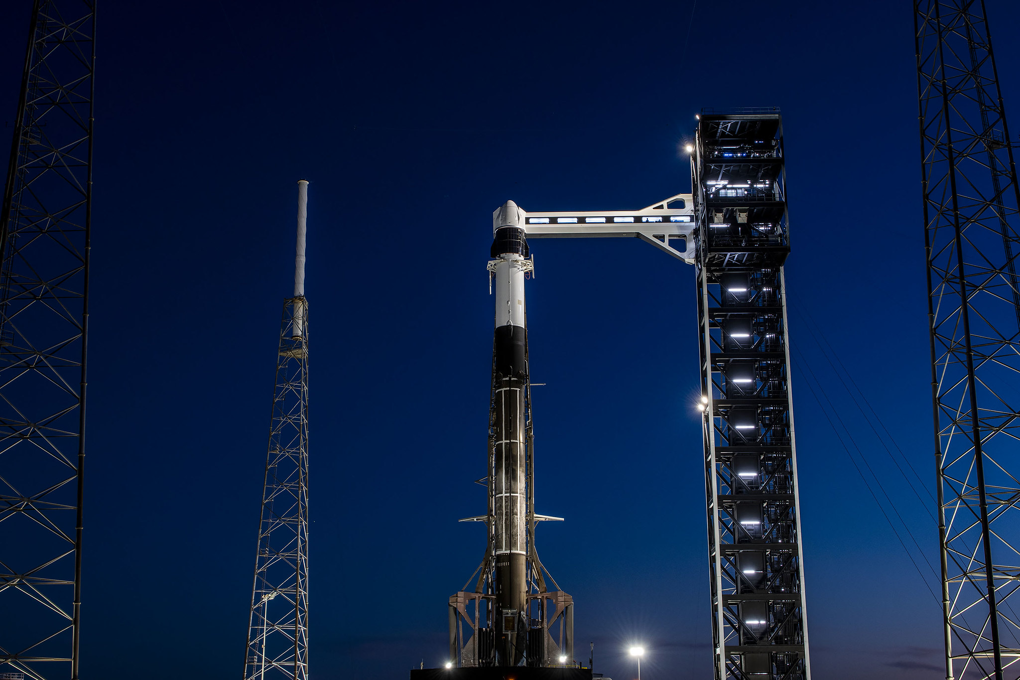
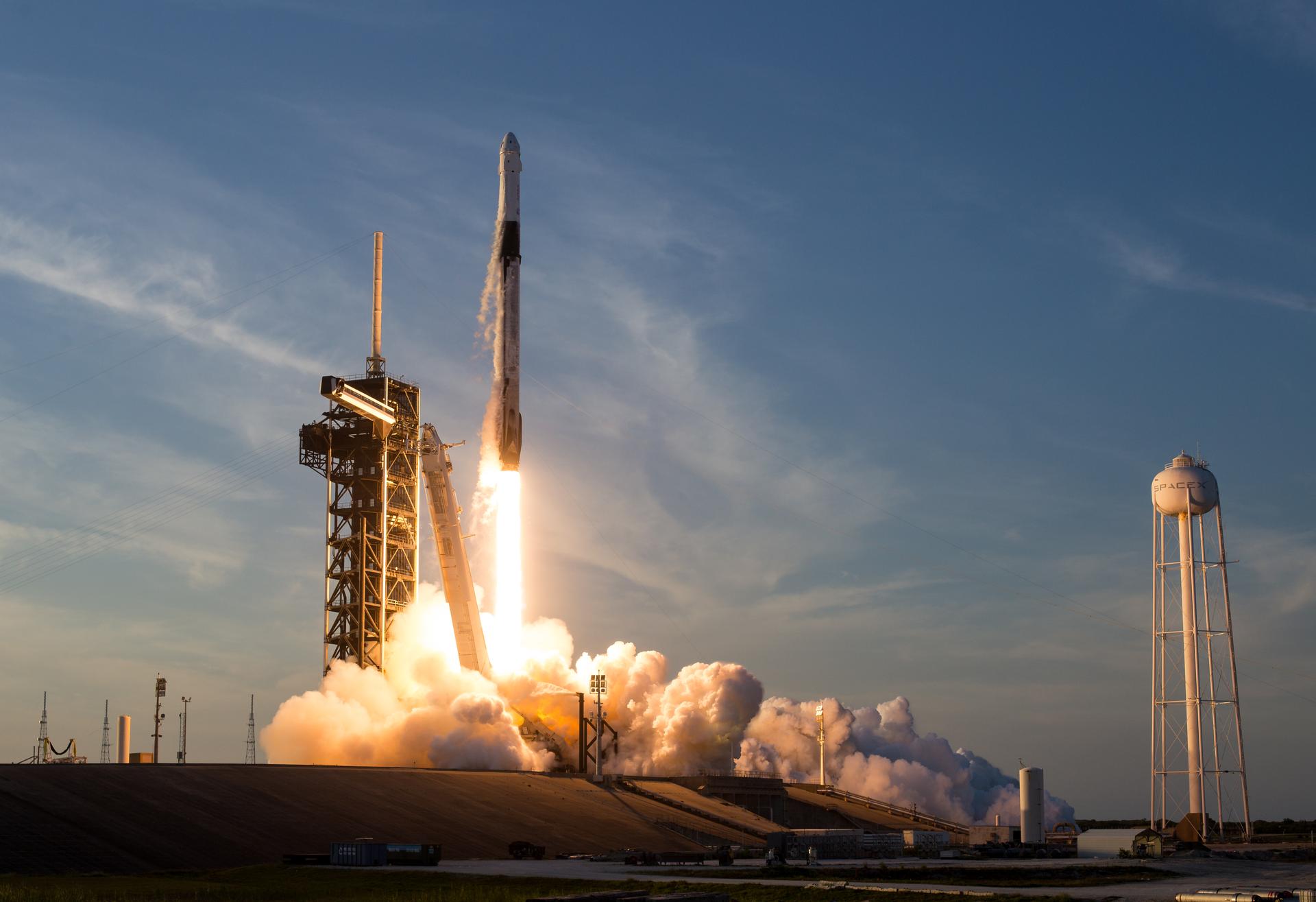
NASA Invites Media to SpaceX’s 33rd Resupply Launch to Space Station
Media accreditation is open for the next launch to deliver NASA science investigations, supplies, and equipment to the International Space Station. This launch is the 33rd SpaceX commercial resupply services mission to the orbital laboratory for NASA and will liftoff on the company’s Falcon 9 rocket.
NASA and SpaceX are targeting no earlier than Thursday, Aug. 21, to launch the SpaceX Dragon spacecraft from Space Launch Complex-40 at Cape Canaveral Space Force Station in Florida.
Credentialing to cover prelaunch and launch activities is open to U.S. media. The application deadline for U.S. citizens is 11:59 p.m. EDT, Sunday, Aug. 3. All accreditation requests must be submitted online at:
Credentialed media will receive a confirmation email upon approval. NASA’s media accreditation policy is available online. For questions about accreditation, or to request special logistical support, email: ksc-media-accreditat@mail.nasa.gov. For other questions, please contact NASA’s Kennedy Space Center newsroom at: 321-867-2468.
Para obtener información sobre cobertura en español en el Centro Espacial Kennedy o si desea solicitor entrevistas en español, comuníquese con Antonia Jaramillo o Messod Bendayan a: antonia.jaramillobotero@nasa.gov o messod.c.bendayan@nasa.gov.
Each resupply mission to the station delivers scientific investigations in the areas of biology and biotechnology, Earth and space science, physical sciences, and technology development and demonstrations. Cargo resupply from U.S. companies ensures a national capability to deliver scientific research to the space station, significantly increasing NASA’s ability to conduct new investigations aboard humanity’s laboratory in space.
In addition to food, supplies, and equipment for the crew, Dragon will deliver several new experiments, including bone-forming stem cells for studying bone loss prevention and materials to 3D print medical implants that could advance treatments for nerve damage on Earth. Dragon also delivers bioprinted liver tissue to study blood vessel development in microgravity and supplies to 3D print metal cubes in space.
For almost 25 years, humans have continuously lived and worked aboard the International Space Station, advancing scientific knowledge and demonstrating new technologies that enable us to prepare for human exploration of the Moon as we prepare for Mars.
Learn more about NASA’s commercial resupply missions at:
-end-
Claire O’Shea
Headquarters, Washington
202-358-1100
claire.a.o’shea@nasa.gov
Stephanie Plucinsky / Steven Siceloff / Danielle Sempsrott
Kennedy Space Center, Fla.
321-876-2468
stephanie.n.plucinsky@nasa.gov / steven.p.siceloff@nasa.gov / danielle.c.sempsrott@nasa.gov
Sandra Jones
Johnson Space Center, Houston
281-483-5111
sandra.p.jones@nasa.gov
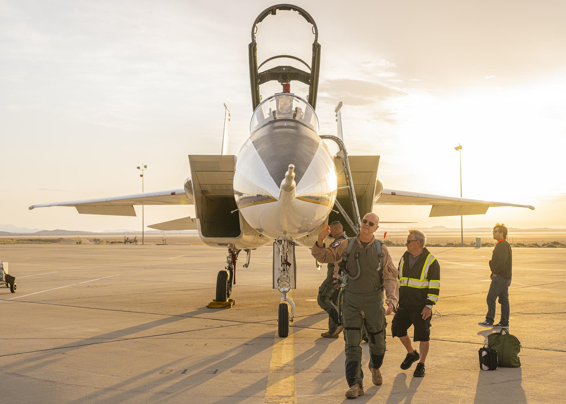
NASA Rehearses How to Measure X-59’s Noise Levels
3 min read
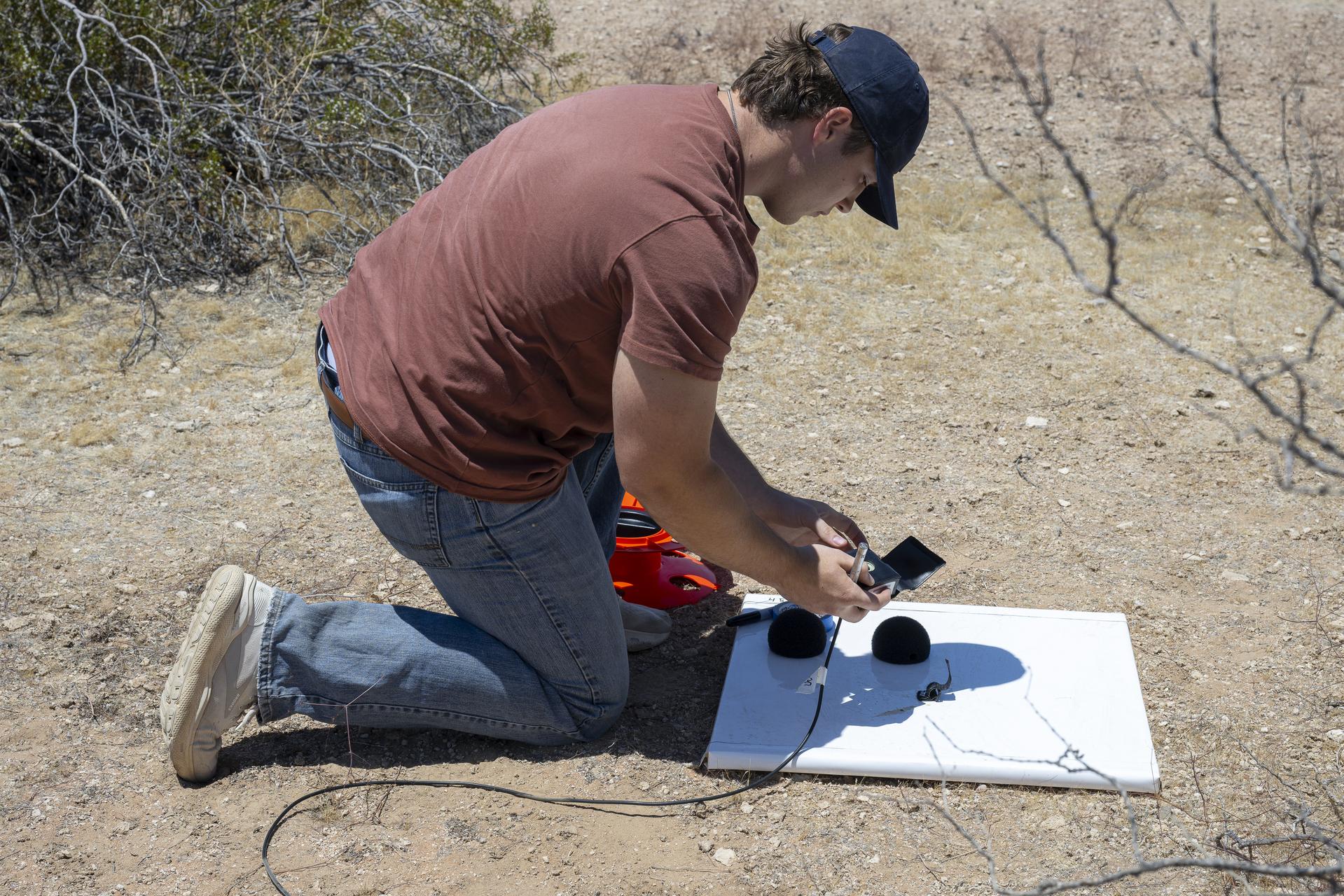
Preparations for Next Moonwalk Simulations Underway (and Underwater) NASA test pilot Nils Larson walks around an F-15B research aircraft for a rehearsal flight supporting the agency’s Quesst mission at NASA’s Armstrong Flight Research Center in Edwards, California. The flight was part of a full-scale dress rehearsal for Phase 2 of the mission, which will eventually measure quiet sonic thumps generated by the X-59. The flight series helped NASA teams refine procedures and practice data collection ahead of future X-59 flights.NASA/Christopher LC ClarkIn a stretch of California’s Mojave Desert, NASA conducted a full-scale “dress rehearsal” to prepare how it will measure the noise generated by the X-59 quiet supersonic research aircraft.
The team behind the successful test flight series operates under NASA’s Commercial Supersonic Technology project. Beginning June 3 and concluding this week, researchers conducted a dry run for Phase 2 of NASA’s Quesst mission, when it will capture audio of the sonic thumps the X-59 will produce, rather than loud sonic booms associated with supersonic flight.
“The dress rehearsal was critical for us,” said Larry Cliatt, sub-project manager for the Quesst acoustic validation phase, who is based at NASA’s Armstrong Flight Research Center in Edwards, California. “It gave us the opportunity to run through every aspect of our operation, from flight planning to data collection. In between those activities, we practiced aircraft operations, setting up the Ground Recording Systems, meteorological data collecting, and refining control room procedures. We were able to fine-tune our timelines, improve communication across teams, and ensure that when we perform these test with the X-59 aircraft, everything will run smoothly.”
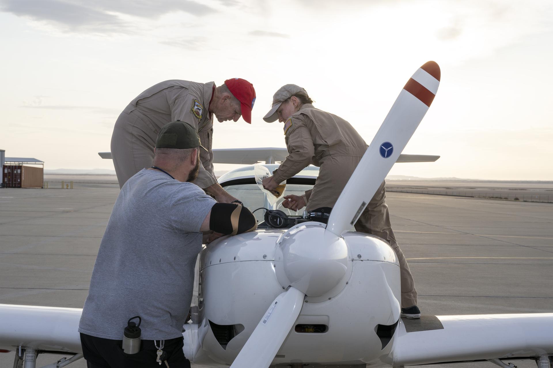
A NASA TG-14 glider aircraft is prepared for flight at NASA’s Armstrong Flight Research Center in Edwards, California, in support of the agency’s Quesst mission. The aircraft is equipped with onboard microphones to capture sonic boom noise generated during rehearsal flights, helping researchers measure the acoustic signature of supersonic aircraft closer to the ground.NASA/Jim RossDuring the tests, at NASA Armstrong, an F-15B aircraft served as a stand-in for the X-59, flying faster than the speed of sound and making multiple passes over the Mojave sands. While it flew, researchers captured acoustic data using a linear array of ground recording systems spaced across miles of open desert, recorded weather readings, and measured the shock waves it generated.
For a supersonic aircraft like the F-15B, shock waves typically result in loud sonic booms, but the X-59 is designed to diffuse them in a way that will dramatically limit noise.
NASA’s Quesst mission aims to enable quiet supersonic flight over land using data from the X-59. The experimental aircraft will begin making its first flights this year – the first phase of Quesst.
A NASA intern sets up ground recording system (GRS) units in California’s Mojave Desert during a Phase 2 rehearsal of the agency’s Quesst mission. The GRS units were placed across miles of desert terrain to capture the acoustic signature of supersonic aircraft during rehearsal flights and in preparation for the start of the actual tests.NASA/Christopher LC ClarkBut even before it takes to the air, the mission began its preparations for Phase 2 with the dry run, which focused on practicing under realistic test conditions and identifying issues before the official campaign begins, not collecting data from the F-15B.
Through Quesst’s development of the X-59, NASA will deliver design tools and technology for quiet supersonic airliners that will achieve the high speeds desired by commercial operators without disturbing people on the ground. NASA will also validate design tools through ground and flight testing, providing aircraft manufacturers the ability to explore new quiet supersonic concepts and have confidence that their resulting designs will meet requirements for quiet flight.
Most importantly, Quesst will gather data to understand community response to sounds generated during flight – key knowledge for a quiet supersonic future.
Share Details Last Updated Jul 24, 2025 EditorDede DiniusContactNicolas Cholulanicolas.h.cholula@nasa.govLocationArmstrong Flight Research Center Related Terms Explore More 4 min read NASA Scientist Finds Predicted Companion Star to Betelgeuse Article 4 days ago 4 min read NASA Tests 5G-Based Aviation Network to Boost Air Taxi Connectivity Article 4 days ago 3 min read NASA Tests Mixed Reality Pilot Simulation in Vertical Motion Simulator Article 4 days ago Keep Exploring Discover More Topics From NASAArmstrong Flight Research Center
Humans in Space
Climate Change
Solar System
NASA Invites Virtual Guests to SpaceX Crew-11 Mission Launch
NASA invites the public to participate as virtual guests in the launch of the agency’s SpaceX Crew-11 mission to the International Space Station.
NASA astronauts Zena Cardman and Mike Fincke, JAXA (Japan Aerospace Exploration Agency) astronaut Kimiya Yui, and Roscosmos cosmonaut Oleg Platonov will launch aboard a SpaceX Dragon spacecraft to the orbiting laboratory. This is the first spaceflight for Cardman and Platonov, the fourth for Fincke, and the second for Yui.
NASA and SpaceX are targeting no earlier than 12:09 p.m. EDT, Thursday, July 31, for launch on the company’s Falcon 9 rocket from Launch Complex 39A at the agency’s Kennedy Space Center in Florida.
Members of the public can register to attend the launch virtually. Virtual guests will receive curated resources, interactive opportunities, mission updates, and a mission-specific collectible stamp for their virtual guest passport after liftoff.
Discover an exciting new way to collect and share passport stamps. Print one for your virtual guest passport and get an extra one, perfect for sharing or digital collecting. Don’t have a passport yet? Print one from the agency’s website and add Crew-11 to your collection.
For more information about the Crew-11 mission, visit:
Hubble Spies Swirling Spiral
- Hubble Home
- Overview
- Impact & Benefits
- Science
- Observatory
- Team
- Multimedia
- News
- More
2 min read
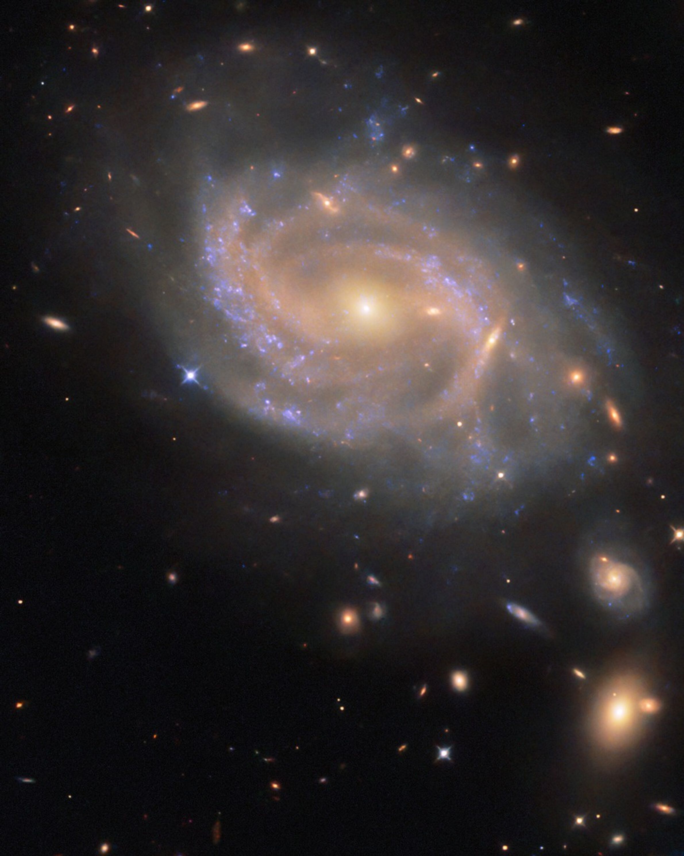
Hubble Spies Swirling Spiral The NASA/ESA Hubble Space Telescope image features the spiral galaxy NGC 3285B, a member of the Hydra I cluster of galaxies. ESA/Hubble & NASA, R. J. Foley (UC Santa Cruz)The swirling spiral galaxy in this NASA/ESA Hubble Space Telescope image is NGC 3285B, which resides 137 million light-years away in the constellation Hydra (the Water Snake). Hydra has the largest area of the 88 constellations that cover the entire sky in a celestial patchwork. It’s also the longest constellation, stretching 100 degrees across the sky. It would take nearly 200 full Moons, placed side by side, to reach from one side of the constellation to the other.
NGC 3285B is a member of the Hydra I cluster, one of the largest galaxy clusters in the nearby universe. Galaxy clusters are collections of hundreds to thousands of galaxies bound to one another by gravity. The Hydra I cluster is anchored by two giant elliptical galaxies at its center. Each of these galaxies is about 150,000 light-years across, making them about 50% larger than our home galaxy, the Milky Way.
NGC 3285B sits on the outskirts of its home cluster, far from the massive galaxies at the center. This galaxy drew Hubble’s attention because it hosted a Type Ia supernova in 2023. Type Ia supernovae happen when a type of condensed stellar core called a white dwarf detonates, igniting a sudden burst of nuclear fusion that briefly shines about 5 billion times brighter than the Sun. The supernova, named SN 2023xqm, is visible here as a blueish dot on the left edge of the galaxy’s disk.
Hubble observed NGC 3285B as part of an observing program that targeted 100 Type Ia supernovae. By viewing each of these supernovae in ultraviolet, optical, and near-infrared light, researchers aim to disentangle the effects of distance and dust, both of which can make a supernova appear redder than it actually is. This program will help refine cosmic distance measurements that rely on observations of Type Ia supernovae.
Text Credit: ESA/Hubble
Facebook logo @NASAHubble @NASAHubble Instagram logo @NASAHubbleMedia Contact:
Claire Andreoli (claire.andreoli@nasa.gov)
NASA’s Goddard Space Flight Center, Greenbelt, MD
Since its 1990 launch, the Hubble Space Telescope has changed our fundamental understanding of the universe.
Hubble’s Night Sky Challenge
Hubble’s Galaxies
Reshaping Our Cosmic View: Hubble Science Highlights
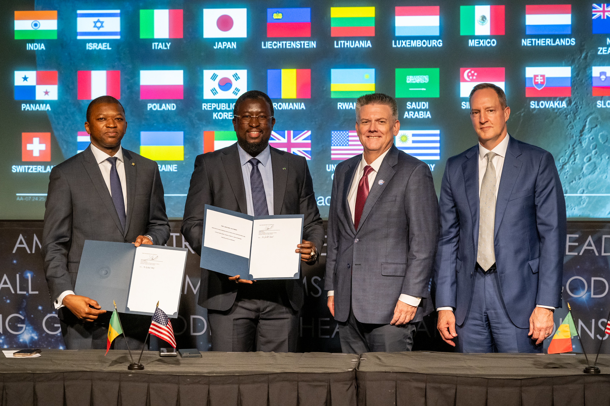
NASA Welcomes Senegal as Newest Artemis Accords Signatory
Senegal signed the Artemis Accords Thursday during a ceremony hosted by NASA at the agency’s headquarters in Washington, becoming the latest nation to commit to the responsible exploration of space for all humanity.
“Following a meeting between Senegal President Faye and President Trump, today, NASA built upon the strong relations between our two nations as the Senegalese Agency for Space Studies signed the Artemis Accords,” said acting NASA Administrator Sean Duffy. “With Senegal as the 56th signatory, I am proud to further President Trump’s strong legacy of global cooperation in space.”
Director General of the Senegalese space agency (ASES) Maram Kairé signed the Artemis Accords on behalf of Senegal. Jonathan Pratt, senior bureau official for African Affairs at the U.S. Department of State, and Abdoul Wahab Haidara, ambassador of Senegal to the United States, also participated in the event.
“Senegal’s adherence to the Artemis Accords reflects our commitment to a multilateral, responsible, and transparent approach to space,” said Kairé. “This signature marks a meaningful step in our space diplomacy and in our ambition to contribute to the peaceful exploration of outer space.”
The Artemis Accords signing ceremony took place two weeks after President Trump’s meeting in Washington with Senegal’s President Bassirou Diomaye Faye and other countries of Africa focused on U.S.-Africa engagement.
Astronomers from Senegal have supported NASA missions by participating in multiple observations when asteroids or planets pass in front of stars, casting shadows on Earth. In 2021, NASA also collaborated with Kairé and a group of astronomers for a ground observation campaign in Senegal. As the asteroid Orus passed in front of a star, they positioned telescopes along the path of the asteroid’s shadow to estimate its shape and size. NASA’s Lucy spacecraft will approach Orus in 2028, as part of its mission to explore Jupiter’s Trojan asteroids.
In 2020, during the first Trump Administration, the United States, led by NASA and the U.S. Department of State, joined with seven other founding nations to establish the Artemis Accords, responding to the growing interest in lunar activities by both governments and private companies.
The accords introduced the first set of practical principles aimed at enhancing the safety, transparency, and coordination of civil space exploration on the Moon, Mars, and beyond.
Signing the Artemis Accords means to explore peaceably and transparently, to render aid to those in need, to ensure unrestricted access to scientific data that all of humanity can learn from, to ensure activities do not interfere with those of others, to preserve historically significant sites and artifacts, and to develop best practices for how to conduct space exploration activities for the benefit of all.
More countries are expected to sign the Artemis Accords in the months and years ahead, as NASA continues its work to establish a safe, peaceful, and prosperous future in space.
Learn more about the Artemis Accords at:
https://www.nasa.gov/artemis-accords
-end-
Bethany Stevens / Elizabeth Shaw
Headquarters, Washington
202-358-1600
bethany.c.stevens@nasa.gov / elizabeth.a.shaw@nasa.gov
NASA Sets Coverage for Agency’s SpaceX Crew-11 Launch, Docking
NASA will provide coverage of the upcoming prelaunch and launch activities for the agency’s SpaceX Crew-11 mission to the International Space Station.
Liftoff is targeted for 12:09 p.m. EDT, Thursday, July 31, from Launch Complex 39A at NASA’s Kennedy Space Center in Florida. The targeted docking time is approximately 3 a.m., Saturday, Aug. 2.
Watch agency launch coverage on NASA+, Netflix, Amazon Prime and more. Learn how to watch NASA content through a variety of platforms, including social media.
The SpaceX Dragon spacecraft will carry NASA astronauts Zena Cardman and Mike Fincke, JAXA (Japan Aerospace Exploration Agency) astronaut Kimiya Yui, and Roscosmos cosmonaut Oleg Platonov to the orbiting laboratory for a science mission. This is the 11th crew rotation mission and the 12th human spaceflight mission for NASA to the space station supported by the Dragon spacecraft since 2020 as part of the agency’s Commercial Crew Program.
The deadline for media accreditation for in person coverage of this launch has passed. The agency’s media credentialing policy is available online. For questions about media accreditation, please email: ksc-media-accreditat@mail.nasa.gov.
Media who need access to NASA live video feeds may subscribe to the agency’s media resources distribution list to receive daily updates and links.
NASA’s mission coverage is as follows (all times Eastern and subject to change based on real-time operations):
Saturday, July 26
1 p.m. – Crew-11 arrival media event at NASA Kennedy with the following participants:
- Zena Cardman, spacecraft commander, NASA
- Mike Fincke, pilot, NASA
- Kimiya Yui, mission specialist, JAXA
- Oleg Platonov, mission specialist, Roscosmos
Watch live coverage of the crew arrival media event on the NASA Kennedy’s social media accounts.
This event is open to in person media only previously credentialed for this event. Follow @NASAKennedy on X for the latest arrival updates.
Wednesday, July 30
5:30 p.m. – Prelaunch news conference with the following participants:
- Ken Bowersox, associate administrator, NASA’s Space Operations Mission Directorate
- Steve Stich, manager, NASA’s Commercial Crew Program
- Dana Weigel, manager, NASA’s International Space Station Program
- William Gerstenmaier, vice president, Build and Flight Reliability, SpaceX
- Sergei Krikalev, deputy director general, Manned and Automated Complexes, Roscosmos
- Naoki Nagai, program manager, International Space Station, Human Spaceflight Technology Directorate, JAXA
NASA will provide live coverage of the news conference on the agency’s YouTube channel.
Media may ask questions in person and via phone. For the dial-in number and passcode, media should contact the Kennedy newsroom no later than one hour prior to the beginning of the news conference at: ksc-newsroom@mail.nasa.gov.
Thursday, July 31
8 a.m. – Launch coverage begins on NASA+, Netflix, and Amazon Prime.
12:09 p.m. – Launch
Following the conclusion of launch coverage, NASA will distribute audio-only discussions between Crew-11, the space station, and flight controllers during Dragon’s transit to the orbital complex. NASA+ coverage resumes at the start of rendezvous and docking and continues through hatch opening and the welcoming remarks.
1:30 p.m. – Postlaunch news conference with the following participants:
- Ken Bowersox, associate administrator, NASA’s Space Operations Mission Directorate
- Steve Stich, manager, NASA’s Commercial Crew Program
- Dana Weigel, manager, NASA’s International Space Station Program
- Sergei Krikalev, deputy director general, Manned and Automated Complexes, Roscosmos
- Kazuyoshi Kawasaki, associate director general, Space Exploration Center/Space Exploration Innovation Hub Center, JAXA
- Sarah Walker, director, Dragon Mission Management, SpaceX
NASA will provide live coverage of the postlaunch news conference on the agency’s YouTube channel.
Media may ask questions in person and via phone. Limited auditorium space will be available for in person participation. For the dial-in number and passcode, please contact the Kennedy newsroom no later than one hour prior to the beginning of the news conference at ksc-newsroom@mail.nasa.gov.
Saturday, Aug. 2
1 a.m. – Arrival coverage begins on NASA+.
3 a.m. – Targeted docking to the space-facing port of the station’s Harmony module.
4:45 a.m. – Hatch opening
5:30 a.m. – Welcome ceremony
All times are estimates and could be adjusted based on real-time operations after launch. Follow the space station blog for the most up-to-date operations information.
Live Video Coverage Prior to Launch
NASA will provide a live video feed of Launch Complex 39A approximately six hours prior to the planned liftoff of the Crew-11 mission. Pending unlikely technical issues, the feed will be uninterrupted until the prelaunch broadcast begins on NASA+, approximately four hours prior to launch. Once the feed is live, find it online at: http://youtube.com/kscnewsroom.
NASA Website Launch Coverage
Launch day coverage of the mission will be available on the NASA website. Coverage will include livestreaming and blog updates beginning no earlier than 8 a.m., July 31, as the countdown milestones occur. On-demand streaming video on NASA+ and photos of the launch will be available shortly after liftoff. For questions about countdown coverage, contact the NASA Kennedy newsroom at 321-867-2468. Follow countdown coverage on the commercial crew or Crew-11 blog.
Attend Launch Virtually
Members of the public may register to attend this launch virtually. NASA’s virtual guest program for this mission also includes curated launch resources, notifications about related opportunities or changes, and a stamp for the NASA virtual guest passport following launch.
Audio Only Coverage
Launch audio also will be available on Launch Information Service and Amateur Television System’s VHF radio frequency 146.940 MHz and KSC Amateur Radio Club’s UHF radio frequency 444.925 MHz, FM mode, heard within Brevard County on the Space Coast.
Watch, Engage on Social Media
Let people know you’re following the mission on X, Facebook, and Instagram by using the hashtags #Crew11 and #NASASocial. You may also stay connected by following and tagging these accounts:
X: @NASA, @NASAKennedy, @Space_Station, @ISS National Lab, @SpaceX
Facebook: NASA, NASAKennedy, ISS, ISS National Lab
Instagram: @NASA, @NASAKennedy, @ISS, @ISSNationalLab, @SpaceX
Coverage en Espanol
Did you know NASA has a Spanish section called NASA en Espanol? Check out NASA en Espanol on X, Instagram, Facebook, and YouTube for additional mission coverage.
Para obtener información sobre cobertura en español en el Centro Espacial Kennedy o si desea solicitar entrevistas en español, comuníquese con Antonia Jaramillo: 321-501-8425; antonia.jaramillobotero@nasa.gov; o Messod Bendayan: 256-930-1371; messod.c.bendayan@nasa.gov.
NASA’s Commercial Crew Program has delivered on its goal of safe, reliable, and cost-effective transportation to and from the International Space Station from the United States through a partnership with American private industry. This partnership is opening access to low Earth orbit and the International Space Station to more people, more science, and more commercial opportunities. For almost 25 years, humans have continuously lived and worked aboard the International Space Station, advancing scientific knowledge and demonstrating new technologies that enable us to prepare for human exploration of the Moon as we prepare for Mars.
For more information about the mission, visit:
https://www.nasa.gov/commercialcrew
-end-
Joshua Finch / Claire O’Shea
Headquarters, Washington
202-358-1100
joshua.a.finch@nasa.gov / claire.a.o’shea@nasa.gov
Steven Siceloff / Stephanie Plucinsky
Kennedy Space Center, Florida
321-867-2468
steven.p.siceloff@nasa.gov / stephanie.n.plucinsky@nasa.gov
Joseph Zakrzewski
Johnson Space Center, Houston
281-483-5111
joseph.a.zakrzewski@nasa.gov
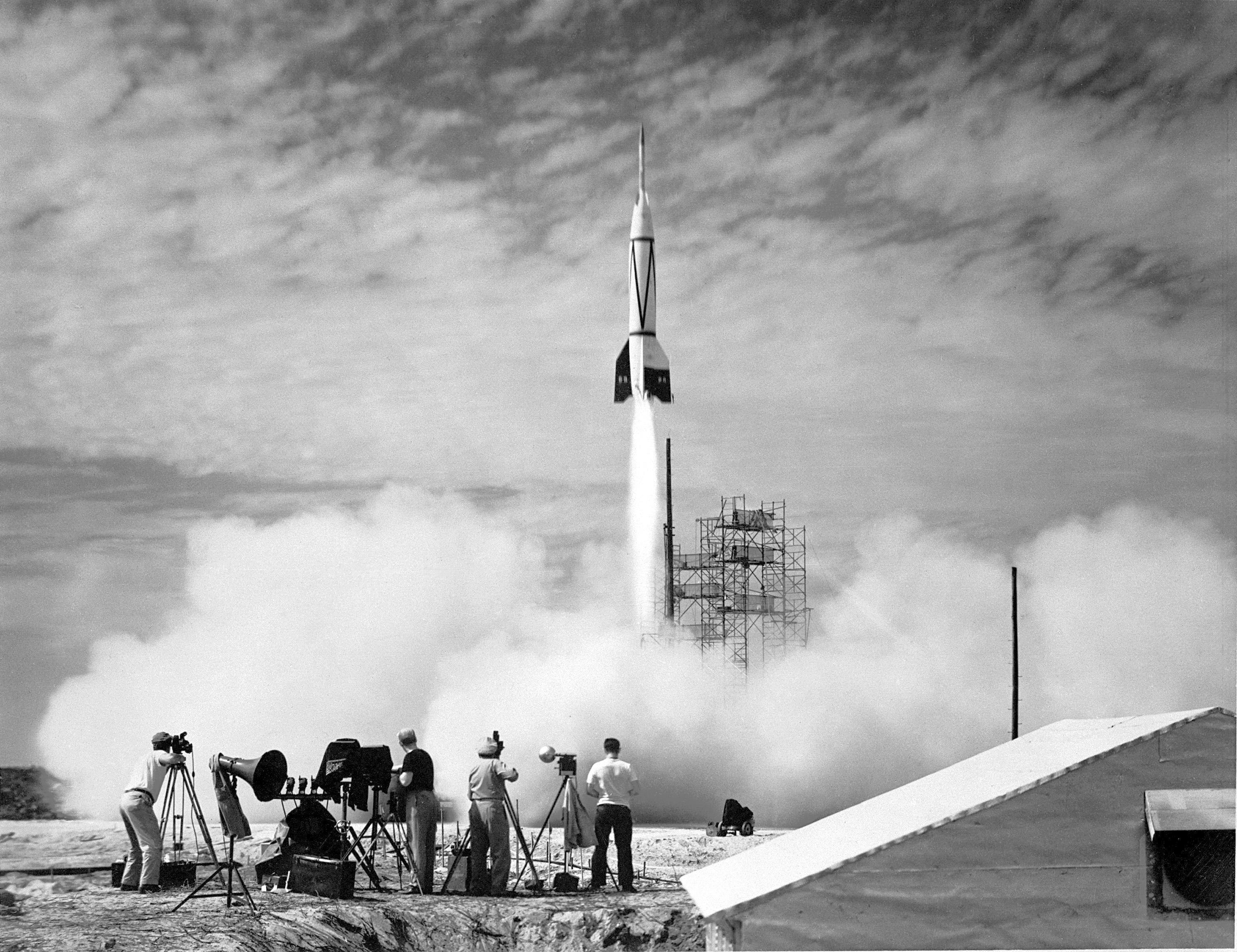
First Rocket Launch from Cape Canaveral
The Bumper V-2 launches from Cape Canaveral in this July 24, 1950, photo. In the 75 years since this milestone, this facility has seen thousands of rockets take to the skies, destined for Earth orbit, the Moon, planets, and even beyond. From Cape Canaveral and from NASA’s Kennedy Space Center in Florida nearby, astronauts launched on the first pioneering crewed missions, headed for Moon landings, and helped to build the International Space Station.
NASA Kennedy, a premier multi-user spaceport with about 100 private-sector partners and nearly 250 partnership agreements, is still the agency’s main launch site. NASA’s SpaceX Crew-11 mission, part of the agency’s Commercial Crew Program, will launch from NASA Kennedy no earlier than 12:09 p.m. EDT, Thursday, July 31. The Crew-11 mission members – NASA astronauts Zena Cardman and Mike Fincke, JAXA (Japan Aerospace Exploration Agency) astronaut Kimiya Yui, and Roscosmos cosmonaut Oleg Platonov – are in crew quarantine before their voyage to the orbital laboratory.
Image credit: NASA
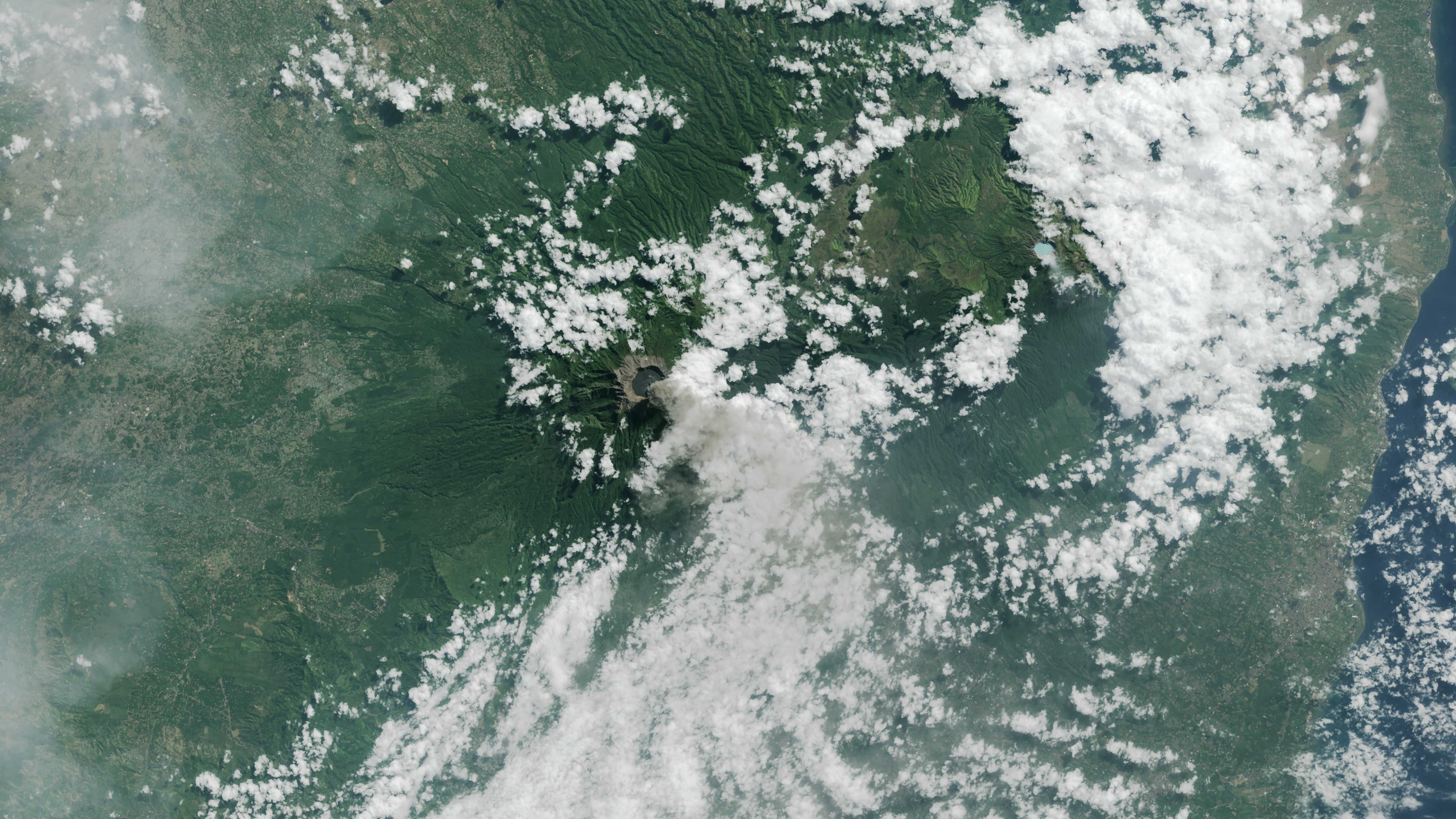
How NASA Is Testing AI to Make Earth-Observing Satellites Smarter
5 min read
Preparations for Next Moonwalk Simulations Underway (and Underwater) Cloud cover can keep optical instruments on satellites from clearly capturing Earth’s surface. Still in testing, JPL’s Dynamic Targeting uses AI to avoid imaging clouds, yielding a higher proportion of usable data, and to focus on phenomena like this 2015 volcanic eruption in Indonesia Landsat 8 captured.NASA/USGSA technology called Dynamic Targeting could enable spacecraft to decide, autonomously and within seconds, where to best make science observations from orbit.
In a recent test, NASA showed how artificial intelligence-based technology could help orbiting spacecraft provide more targeted and valuable science data. The technology enabled an Earth-observing satellite for the first time to look ahead along its orbital path, rapidly process and analyze imagery with onboard AI, and determine where to point an instrument. The whole process took less than 90 seconds, without any human involvement.
Called Dynamic Targeting, the concept has been in development for more than a decade at NASA’s Jet Propulsion Laboratory in Southern California. The first of a series of flight tests occurred aboard a commercial satellite in mid-July. The goal: to show the potential of Dynamic Targeting to enable orbiters to improve ground imaging by avoiding clouds and also to autonomously hunt for specific, short-lived phenomena like wildfires, volcanic eruptions, and rare storms.
This graphic shows how JPL’s Dynamic Targeting uses a lookahead sensor to see what’s on a satellite’s upcoming path. Onboard algorithms process the sensor’s data, identifying clouds to avoid and targets of interest for closer observation as the satellite passes overhead.NASA/JPL-Caltech“The idea is to make the spacecraft act more like a human: Instead of just seeing data, it’s thinking about what the data shows and how to respond,” says Steve Chien, a technical fellow in AI at JPL and principal investigator for the Dynamic Targeting project. “When a human sees a picture of trees burning, they understand it may indicate a forest fire, not just a collection of red and orange pixels. We’re trying to make the spacecraft have the ability to say, ‘That’s a fire,’ and then focus its sensors on the fire.”
Avoiding Clouds for Better ScienceThis first flight test for Dynamic Targeting wasn’t hunting specific phenomena like fires — that will come later. Instead, the point was avoiding an omnipresent phenomenon: clouds.
Most science instruments on orbiting spacecraft look down at whatever is beneath them. However, for Earth-observing satellites with optical sensors, clouds can get in the way as much as two-thirds of the time, blocking views of the surface. To overcome this, Dynamic Targeting looks 300 miles (500 kilometers) ahead and has the ability to distinguish between clouds and clear sky. If the scene is clear, the spacecraft images the surface when passing overhead. If it’s cloudy, the spacecraft cancels the imaging activity to save data storage for another target.
“If you can be smart about what you’re taking pictures of, then you only image the ground and skip the clouds. That way, you’re not storing, processing, and downloading all this imagery researchers really can’t use,” said Ben Smith of JPL, an associate with NASA’s Earth Science Technology Office, which funds the Dynamic Targeting work. “This technology will help scientists get a much higher proportion of usable data.”
How Dynamic Targeting WorksThe testing is taking place on CogniSAT-6, a briefcase-size CubeSat that launched in March 2024. The satellite — designed, built, and operated by Open Cosmos — hosts a payload designed and developed by Ubotica featuring a commercially available AI processor. While working with Ubotica in 2022, Chien’s team conducted tests aboard the International Space Station running algorithms similar to those in Dynamic Targeting on the same type of processor. The results showed the combination could work for space-based remote sensing.
Since CogniSAT-6 lacks an imager dedicated to looking ahead, the spacecraft tilts forward 40 to 50 degrees to point its optical sensor, a camera that sees both visible and near-infrared light. Once look-ahead imagery has been acquired, Dynamic Targeting’s advanced algorithm, trained to identify clouds, analyzes it. Based on that analysis, the Dynamic Targeting planning software determines where to point the sensor for cloud-free views. Meanwhile, the satellite tilts back toward nadir (looking directly below the spacecraft) and snaps the planned imagery, capturing only the ground.
This all takes place in 60 to 90 seconds, depending on the original look-ahead angle, as the spacecraft speeds in low Earth orbit at nearly 17,000 mph (7.5 kilometers per second).
What’s NextWith the cloud-avoidance capability now proven, the next test will be hunting for storms and severe weather — essentially targeting clouds instead of avoiding them. Another test will be to search for thermal anomalies like wildfires and volcanic eruptions. The JPL team developed unique algorithms for each application.
“This initial deployment of Dynamic Targeting is a hugely important step,” Chien said. “The end goal is operational use on a science mission, making for a very agile instrument taking novel measurements.”
There are multiple visions for how that could happen — possibly even on spacecraft exploring the solar system. In fact, Chien and his JPL colleagues drew some inspiration for their Dynamic Targeting work from another project they had also worked on: using data from ESA’s (the European Space Agency’s) Rosetta orbiter to demonstrate the feasibility of autonomously detecting and imaging plumes emitted by comet 67P/Churyumov-Gerasimenko.
On Earth, adapting Dynamic Targeting for use with radar could allow scientists to study dangerous extreme winter weather events called deep convective ice storms, which are too rare and short-lived to closely observe with existing technologies. Specialized algorithms would identify these dense storm formations with a satellite’s look-ahead instrument. Then a powerful, focused radar would pivot to keep the ice clouds in view, “staring” at them as the spacecraft speeds by overhead and gathers a bounty of data over six to eight minutes.
Some ideas involve using Dynamic Targeting on multiple spacecraft: The results of onboard image analysis from a leading satellite could be rapidly communicated to a trailing satellite, which could be tasked with targeting specific phenomena. The data could even be fed to a constellation of dozens of orbiting spacecraft. Chien is leading a test of that concept, called Federated Autonomous MEasurement, beginning later this year.
How AI supports Mars rover science Autonomous robot fleet could measure ice shelf melt Ocean world robot swarm prototype gets a swim test News Media ContactMelissa Pamer
Jet Propulsion Laboratory, Pasadena, Calif.
626-314-4928
melissa.pamer@jpl.nasa.gov
2025-094
Share Details Last Updated Jul 24, 2025 Related Terms Explore More 5 min read NASA Shares How to Save Camera 370-Million-Miles Away Near Jupiter Article 6 days ago 2 min read GLOBE-Trotting Science Lands in Chesapeake with NASA eClipsOn June 16-17, 2025, 50 students at Camp Young in Chesapeake, Virginia traded their usual…
Article 6 days ago 6 min read 5 Things to Know About Powerful New U.S.-India Satellite, NISAR Article 7 days ago Keep Exploring Discover Related TopicsMissions
Humans in Space
Climate Change
Solar System
NASA’s Hubble, Chandra Spot Rare Type of Black Hole Eating a Star
- Hubble Home
- Overview
- Impact & Benefits
- Science
- Observatory
- Team
- Multimedia
- News
- More
NASA, ESA, CXC, Yi-Chi Chang (National Tsing Hua University); Image Processing: Joseph DePasquale (STScI)
NASA’s Hubble Space Telescope and NASA’s Chandra X-ray Observatory have teamed up to identify a new possible example of a rare class of black holes. Called NGC 6099 HLX-1, this bright X-ray source seems to reside in a compact star cluster in a giant elliptical galaxy.
Just a few years after its 1990 launch, Hubble discovered that galaxies throughout the universe can contain supermassive black holes at their centers weighing millions or billions of times the mass of our Sun. In addition, galaxies also contain as many as millions of small black holes weighing less than 100 times the mass of the Sun. These form when massive stars reach the end of their lives.
Far more elusive are intermediate-mass black holes (IMBHs), weighing between a few hundred to a few 100,000 times the mass of our Sun. This not-too-big, not-too-small category of black holes is often invisible to us because IMBHs don’t gobble as much gas and stars as the supermassive ones, which would emit powerful radiation. They have to be caught in the act of foraging in order to be found. When they occasionally devour a hapless bypassing star — in what astronomers call a tidal disruption event— they pour out a gusher of radiation.
The newest probable IMBH, caught snacking in telescope data, is located on the galaxy NGC 6099’s outskirts at approximately 40,000 light-years from the galaxy’s center, as described in a new study in the Astrophysical Journal. The galaxy is located about 450 million light-years away in the constellation Hercules.
A Hubble Space Telescope image of a pair of galaxies: NGC 6099 (lower left) and NGC 6098 (upper right). The purple blob depicts X-ray emission from a compact star cluster. The X-rays are produced by an intermediate-mass black hole tearing apart a star. Science: NASA, ESA, CXC, Yi-Chi Chang (National Tsing Hua University); Image Processing: Joseph DePasquale (STScI)Astronomers first saw an unusual source of X-rays in an image taken by Chandra in 2009. They then followed its evolution with ESA’s XMM-Newton space observatory.
“X-ray sources with such extreme luminosity are rare outside galaxy nuclei and can serve as a key probe for identifying elusive IMBHs. They represent a crucial missing link in black hole evolution between stellar mass and supermassive black holes,” said lead author Yi-Chi Chang of the National Tsing Hua University, Hsinchu, Taiwan.
X-ray emission coming from NGC 6099 HLX-1 has a temperature of 3 million degrees, consistent with a tidal disruption event. Hubble found evidence for a small cluster of stars around the black hole. This cluster would give the black hole a lot to feast on, because the stars are so closely crammed together that they are just a few light-months apart (about 500 billion miles).
The suspected IMBH reached maximum brightness in 2012 and then continued declining to 2023. The optical and X-ray observations over the period do not overlap, so this complicates the interpretation. The black hole may have ripped apart a captured star, creating a plasma disk that displays variability, or it may have formed a disk that flickers as gas plummets toward the black hole.
“If the IMBH is eating a star, how long does it take to swallow the star’s gas? In 2009, HLX-1 was fairly bright. Then in 2012, it was about 100 times brighter. And then it went down again,” said study co-author Roberto Soria of the Italian National Institute for Astrophysics (INAF). “So now we need to wait and see if it’s flaring multiple times, or there was a beginning, there was peak, and now it’s just going to go down all the way until it disappears.”
The IMBH is on the outskirts of the host galaxy, NGC 6099, about 40,000 light-years from the galaxy’s center. There is presumably a supermassive black hole at the galaxy’s core, which is currently quiescent and not devouring a star.
Black Hole Building BlocksThe team emphasizes that doing a survey of IMBHs can reveal how the larger supermassive black holes form in the first place. There are two alternative theories. One is that IMBHs are the seeds for building up even larger black holes by coalescing together, since big galaxies grow by taking in smaller galaxies. The black hole in the middle of a galaxy grows as well during these mergers. Hubble observations uncovered a proportional relationship: the more massive the galaxy, the bigger the black hole. The emerging picture with this new discovery is that galaxies could have “satellite IMBHs” that orbit in a galaxy’s halo but don’t always fall to the center.
Another theory is that the gas clouds in the middle of dark-matter halos in the early universe don’t make stars first, but just collapse directly into a supermassive black hole. NASA’s James Webb Space Telescope’s discovery of very distant black holes being disproportionately more massive relative to their host galaxy tends to support this idea.
However, there could be an observational bias toward the detection of extremely massive black holes in the distant universe, because those of smaller size are too faint to be seen. In reality, there could be more variety out there in how our dynamic universe constructs black holes. Supermassive black holes collapsing inside dark-matter halos might simply grow in a different way from those living in dwarf galaxies where black-hole accretion might be the favored growth mechanism.
“So if we are lucky, we’re going to find more free-floating black holes suddenly becoming X-ray bright because of a tidal disruption event. If we can do a statistical study, this will tell us how many of these IMBHs there are, how often they disrupt a star, how bigger galaxies have grown by assembling smaller galaxies.” said Soria.
The challenge is that Chandra and XMM-Newton only look at a small fraction of the sky, so they don’t often find new tidal disruption events, in which black holes are consuming stars. The Vera C. Rubin Observatory in Chile, an all-sky survey telescope from the U.S. National Science Foundation and the Department of Energy, could detect these events in optical light as far as hundreds of millions of light-years away. Follow-up observations with Hubble and Webb can reveal the star cluster around the black hole.
The Hubble Space Telescope has been operating for more than three decades and continues to make ground-breaking discoveries that shape our fundamental understanding of the universe. Hubble is a project of international cooperation between NASA and ESA (European Space Agency). NASA’s Goddard Space Flight Center in Greenbelt, Maryland, manages the telescope and mission operations. Lockheed Martin Space, based in Denver, also supports mission operations at Goddard. The Space Telescope Science Institute in Baltimore, which is operated by the Association of Universities for Research in Astronomy, conducts Hubble science operations for NASA.
Facebook logo @NASAHubble @NASAHubble Instagram logo @NASAHubble Related Images & Videos NGC 6099 (Hubble + Chandra)A Hubble Space Telescope image of a pair of galaxies: NGC 6099 (lower left) and NGC 6098 (upper right). The purple blob depicts X-ray emission from a compact star cluster. The X-rays are produced by an intermediate-mass black hole tearing apart a star.
NGC 6099 (Hubble)
A Hubble Space Telescope image of a pair of galaxies: NGC 6099 (lower left) and NGC 6098 (upper right). The white dot labeled HLX-1 is the visible-light component of the location of a compact star cluster where an intermediate-mass black hole is tearing apart a star.
NGC 6099 Compass Image
This compass image shows two elliptical galaxies, NGC 6098 at upper right and NGC 6099 at lower left. The fuzzy purple blob at bottom center shows X-ray emission produced by an intermediate-mass black hole tearing apart a star.
HLX-1 Illustration
This sequence of artistic illustrations, from upper left to bottom right, shows how a black hole in the core of a star cluster captures a bypassing star and gravitationally shreds it until there is an explosion, seen in the outskirts of the host galaxy.
HLX-1 Animation
This video is an illustration of an intermediate-mass black hole capturing and gravitationally shredding a star. It begins by zooming into a pair of galaxies. The galaxy at lower left, NGC 6099, contain a dense star cluster at center. The video then zooms into the heart of the cl…
Claire Andreoli
NASA’s Goddard Space Flight Center
Greenbelt, Maryland
claire.andreoli@nasa.gov
Ray Villard
Space Telescope Science Institute
Baltimore, Maryland
Keep Exploring Discover More Topics From Hubble Hubble Space Telescope
Since its 1990 launch, the Hubble Space Telescope has changed our fundamental understanding of the universe.
Reshaping Our Cosmic View: Hubble Science Highlights
Hubble Black Holes
Hubble Focus: Black Holes – Into the Vortex
