
Feed aggregator
Lego wants you to vote on a new color for its astronaut minifigures
Summary of the 2023 Ocean Surface Topography Science Team Meeting
16 min read
Summary of the 2023 Ocean Surface Topography Science Team MeetingSeverine Fournier, NASA/Jet Propulsion Laboratory, severine.fournier@jpl.nasa.gov
Joshua Willis, NASA/Jet Propulsion Laboratory, joshua.k.willis@jpl.nasa.gov
Introduction
The annual Ocean Surface Topography (OST) Science Team Meeting (STM) provides a forum for the international altimetry community to foster collaboration, address specific issues, and highlight scientific results and applications every year. The meeting location alternates between Europe and the U.S. The 2023 meeting was held in San Juan, Puerto Rico, from November 7–11, 2023. About 130 registrants from more than a dozen different countries attended the meeting.
During this meeting the OST Science Team addressed specific technical issues related to the reference altimetry missions, which include the Ocean Topography Experiment (TOPEX)–Poseidon (1992–2006), Jason-1 (2001–2013), Ocean Surface Topography Mission (OSTM)/Jason-2 (2008–2019), Jason-3 (2016–present), and Sentinel-6 Michael Freilich (S6MF; 2020–present) missions. There was also discussion about the upcoming Sentinel-6B mission (scheduled for launch in 2025), which will be a successor to S6MF. The technical issues addressed included algorithm and model improvement, calibration/validation (cal/val) activities, merging TOPEX–Poseidon–Jason–S6MF data with those from other altimetric satellites, initial results from the Surface Water and Ocean Topography (SWOT) mission (2022–present), and preparation for future OST missions (e.g., Sentinel-6B).
The remainder of this article provides an overview of the meeting content, then presents an update on the status of current and planned OST missions, followed by a summary of the opening plenary and a couple of the most relevant science highlights from the splinter sessions. More details are available in the full report from the OST STM. The full OST STM program lists all of the presentations from the plenary, splinter, and poster sessions as well as links to many of the presentations and abstracts for the posters.
Meeting Overview
The meeting began with an opening plenary session, followed by an invited presentation, a series of splinter sessions, and a closing plenary session. The splinter session topics spanned a variety of algorithm improvements and measurement uncertainties, as well as sessions on coastal altimetry, the Chinese–French Oceanography Satellite (CFOSAT) mission (2019–present), and science topics ranging from climate and oceanography to hydrology and cryosphere science. A complete list of splinters is available online. Some of these are described in more detail in the sections that follow.
Status Report on Current OST Missions
This section reports on the status of several current and planned OST-related satellite missions. Each is described in its own subsection.
Sentinel-6 Michael Freilich
S6MF, launched on November 21, 2020, from Vandenberg Space Force Base, successfully completed its commissioning and subsequent entry into routine operations on schedule, one year later. S6MF succeeded Jason-3 as the Reference Mission (i.e., the mission that other altimetry missions are compared to) on April 7, 2022, at which point Jason-3 vacated the reference orbit. The first full mission reprocessing of products was released in July 2022, and another full reprocessing was completed in July 2023.
Jason-3
Jason-3, launched on January 17, 2016, continues its extended mission and is fully operational with all redundant systems available. It completed a longer than initially planned 15-month tandem phase with S6MF, which allowed for calibrations of both the primary and redundant instruments. On April 25, 2022, it began operations in an orbit that optimally interleaves ground tracks with S6MF. A second tandem phase with S6MF has been requested for early 2025. The second tandem phase aims to place an uncertainty bound on any long-term drift between the two missions.
Copernicus Copernicus Sentinel-3A and -3B
Sentinel-3A and -3B are identical satellites that were launched in February 16, 2016 and April 25, 2018, respectively. Similar to past missions in the reference orbit, a tandem phase with a separation of 30 seconds between the two satellites was performed to provide cross-calibration. Subsequently, Sentinel-3B was placed in a nominal orbit 140° out of phase with Sentinel-3A. Both missions now provide sea level measurements along high inclination tracks as part of their routine operations. A full mission reprocessing of land altimetry Level-2 (L2) products was completed in 2023.
Copernicus Sentinel-6B and 6C Missions and Beyond
Identical to S6MF, Sentinel-6B is planned as its successor. The spacecraft and instrument have been completed and is now in storage awaiting launch in 2025. Sentinel-6B will assure operational continuity through the end of 2030. An additional satellite, Sentinel-6C, is under consideration by NASA, the National Oceanic and Atmospheric Administration (NOAA), the European Organization for the Exploitation of Meteorological Satellites (EUMETSAT), the European Space Agency (ESA), and the Centre National d’Études Spatiale (CNES) [French Space Agency] to continue observations through 2035.
Surface Water Ocean Topography
SWOT launched on December 16, 2022. The primary instrument on SWOT, Ka-band radar interferometer (KaRIn), is the first space-borne, wide-swath altimetry instrument, capable of high-resolution measurements of the water height in the ocean and freshwater bodies. After commissioning and initial calibration, beta products became available to the science team in August 2023. The first images from SWOT were released, and the first results are showing great promise for the instrument capabilities (see NASA and CNES news).
Discussion of Future Missions Relevant to OST
The meeting continued with presentations on several existing and upcoming missions in various stages of development, each with applications relevant to OST. Each presentation included information on the mission’s status and development plans, as described below.
Copernicus Polar Ice and Snow Topography Altimeter (CRISTAL)
Copernicus Polar Ice and Snow Topography Altimeter (CRISTAL) is one of six, high-priority candidate Copernicus Sentinel Expansion missions that are being studied to address the European Union’s needs, as well as to extend the current capabilities of the Copernicus space components. CRISTAL will carry a multifrequency radar altimeter and microwave radiometer to ensure continuity and improve the quality of sea ice thickness measurements compared to its predecessor, Cryosat-2, and provide the first space-based measurements of overlying snow depth.
Recommendations from the OST Science Team
After discussing these missions and other issues concerning altimetry, the OST STM adopted several recommendations to particular topics relating to these missions, which are named and described in the subsections that follow:
S6MF Extended Operations Phase Orbit.
In light of that fact that user needs remain very high for altimetry observations complementary to the reference mission, the OST ST recommends extending operations of S6MF – assuming it remains in good health – beyond the time when Sentinel-6B has become the reference mission. Specifically, the OST ST recommends:
- Moving S6MF to an exact repeat orbit with the same characteristics as the reference orbit – except for a phase difference of 163° along the orbit, either ahead or behind Sentinel-6B – resulting in an interleaved ground-track to the reference orbit. (For reference, Jason-3 currently flies 163° behind S6MF.)
- Adopting the same data availability requirements as expressed in the End-User Requirements Document (EURD) (R-U- 00460/490/500/515/520/570/573/576) for the extended operations phase of S6MF, with the understanding that Sentinel-6B operations will be prioritized over S6MF.
Jason-3 Orbit Change.
The OST ST endorses the current plan to move Jason-3 to a Long Repeat Orbit (LRO) immediately after the conclusion of second tandem with S6MF. This 371-nodal-day LRO should be the same as the one occupied by Jason-2. The first two LRO cycles should be phased such that Jason-3 will interleave the two Jason-2 LRO cycles, each shifted by 2 km (1.2 mi). This will result in a systematic 2-km global grid combining Jason-2 and Jason-3 LRO data. The OST ST also recommends two additional LRO cycles that revisit the Jason-2 LRO ground tracks to fill in gaps and reduce mean sea surface errors.
Climate Quality Accuracy in Future Mission
To achieve accuracy in global and regional sea level change as detailed in the Global Climate Observing System (GCOS) requirements, the OST ST noted that it will be necessary to maintain and continue to improve the accuracy of orbital determination systems, such as those achieved using a combination of three tracking systems – Satellite Laser Ranging [SLR], Doppler Orbitography and Radiopositioning Integrated by Satellite (DORIS), and Global Navigation Satellite System [GNSS]). The OST ST has demonstrated that these tracking systems are necessary to achieve maximum accuracy on the determination of regional sea level trends and strongly recommends that such accuracy be maintained in the design of Sentinel-6C. The OST ST also noted that accuracy of the Climate Data Record requires continued maintenance or improvement of the terrestrial reference frame, which also relies on these tracking systems. Finally, requirements on other aspects of the altimetric measurement system must also be maintained or continue to improve.
Synergies with Argo and GRACE
Argo (which is an international fleet of robotic instruments that drift with the ocean currents and measure the temperature and salinity of the ocean) plays a critical role in collecting data related to numerous cross-cutting, climate-related science topics important to altimetry measurements (missions discussed earlier in this article), to gravity measurements [e.g., the Gravity Recovery and Climate Experiment (GRACE) and GRACE-Follow-On missions], and to broader science communities. The recent implementation of the Deep Argo mission has rapidly expanded observations of the ocean below 2000 m (~6500 ft). Data collected at these depths has helped to resolve questions about variations of temperature and salinity over the full depth of the ocean and to close regional and global sea level budgets. The OST ST recommends substantially increasing support for the OneArgo Program (which has been part of Argo’s design plan since 2020), including adding resources to expand the array to include global implementation of Deep Argo and increase coverage by Core Argo (the fleet of shallower floats) in polar regions and marginal seas.
Altimetry Product Evolution
OST ST recommends that agencies study the performance of the three latency products – Near Real-Time (NRT), Short Time-Critical (STC), and Non-Time Critical (NTC) – to ensure each continues to meet user needs or determine if their performance and latencies be redefined or adjusted. This should be considered across all platforms.
Potential Gap between CryoSat-2 and CRISTAL
The OST ST recommends studies to address which satellites, airborne operations, or other assets might help fulfill scientific needs for high-latitude ocean and ice elevation measurements during a potential gap between CryoSat-2 and CRISTAL. The OST ST also recommends minimizing the probability of a gap by extending CryoSat-2 operations through at least 2028 and avoiding delays in the launch of CRISTAL to the extent possible.
Integrity of the Altimetry Constellation and Instrument Function
In light of ongoing efforts to launch a large number of communications satellites in orbits close to the 1336 km (830 mi) altimetry constellation, the OST ST recommends that agencies take steps to determine and establish sufficient margins that will safeguard altimetry missions in both reference and polar orbits from collision, debris, and interference with their passive and active instruments.
Opening Plenary Session Highlights
Severine Fournier [NASA/Jet Propulsion Laboratory (JPL)] began with welcoming remarks on behalf of all of the project scientists, who (in addition to herself) include Josh Willis [NASA/JPL], Pascal Bonnefond [CNES], Eric Leuliette [NOAA], Remko Scharroo [EUMETSAT], and Alejandro Egido [ESA]. In particular, Fournier reminded the participants of the addition of online forums, available until the next OST STM that can be accessed after logging into the site. In addition, Fournier announced that Egido will replace Craig Donlon as the ESA Project Scientist.
Program managers gave presentations on the status of altimetry and oceanographic programs at their respective institutions including: Nadya Vinogradova-Shiffer [NASA Headquarters], Annick Sylvestre-Baron [CNES], Estelle Obligis [EUMETSAT], Eric Leuliette, and Jérôme Bouffard [ESA].
In addition, Josh Willis presented Space Stories, a think tank for U.S.-based creatives and technologists to develop new storytelling approaches to sea level rise. This initiative is organized by Garage Stories and consists of masterclasses that were held in November 2023 with 15 participants across 5 teams. The winning team will have the opportunity to present their concept at JPL in 2024.
Finally, Fernando E. Pabón [Caribbean Center for Rising Seas—Director] spoke about climate issues that impact Puerto Rico. The island has about three million inhabitants and faces several climatic issues, including devastating impacts from hurricanes (with a hurricane season stretching over six months every year), sea level rise, and droughts. While Puerto Rico has a lot of outdated infrastructures, the territory has the most advanced regulatory environment in the Caribbeans. Pabón explained the economic, social, and geographical urgency of making good decisions to help the communities facing climatic challenges with a long-term vision. One of the goals of the Caribbean Center for Rising Seas is to work with practitioners and the public to change urban development practices, update building codes, zoning, and land-use regulations and spread the knowledge and understanding of sea level rise and flooding to the public.
Science Highlights
This section provides two scientifically compelling results that were shown during the splinter sessions. Complete coverage of the results shared during these sessions can be found at the website at the start of the article.
Synergies between Argo, GRACE, and Altimetry
Human activities are increasing the concentration of greenhouse gases, which have increased global temperature since the beginning of the twentieth century. Greenhouse gases trap energy within the Earth system. The ocean absorbs much of this excess energy in the form of heat (> 90%), acting as a huge heat reservoir. Global ocean heat content (GOHC) is therefore a key component in the Earth’s energy budget. Accurate knowledge of the GOHC change allows us to assess the Earth Energy Imbalance (EEI), which refers to the difference between the amount of energy the Earth receives from the Sun and the amount of energy it radiates back into space.
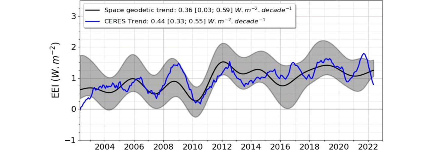
Various methodologies exist to estimate EEI from the GOHC. A 2022 article in Earth System Science Data describes the space geodetic approach, which relies on satellite altimetry and gravimetry measurements. Satellite altimetry is used to measure sea level rise, which is caused by both the expansion of warming ocean waters and the addition of freshwater to the ocean from melting land ice (Greenland and Antarctic ice sheets and mountain glaciers). Gravimetric measurements are used to measure ocean mass change, which can be used to estimate the contribution to sea level rise from freshwater ice melt on land. By combining gravimetry and altimetry, it is possible to estimate the thermal expansion of the entire ocean and scale it to estimate EEI – see Figure 1. The magnitude of EEI is small (0.5–1.0 W/m2) compared to the total amount of energy entering and leaving the climate system (~340 W/m2). Therefore, a high level of precision and accuracy are required to estimate the EEI mean (< 0.3 W/m2) and its time variations at decadal scales (< 0.1 W/m2). In this regard, the space geodetic approach emerges as a promising candidate capable of complementing other observing system elements aimed at measuring EEI.
Figure 1. This graph shows the decadal variations of the Earth Energy Imbalance (EEI) estimated from the space geodetic method that combines altimetry and gravimetric measurements (black) and direct measurements of solar radiation at the top of the atmosphere from the Clouds and the Earth’s Radiant Energy System (CERES) instrument (blue). The grey shaded area corresponds to the space geodetic method’s uncertainty. Image credit: Michael Ablain/Collect Localisation Services (CLS), FranceLarge-scale Ocean Circulation Variability and Change
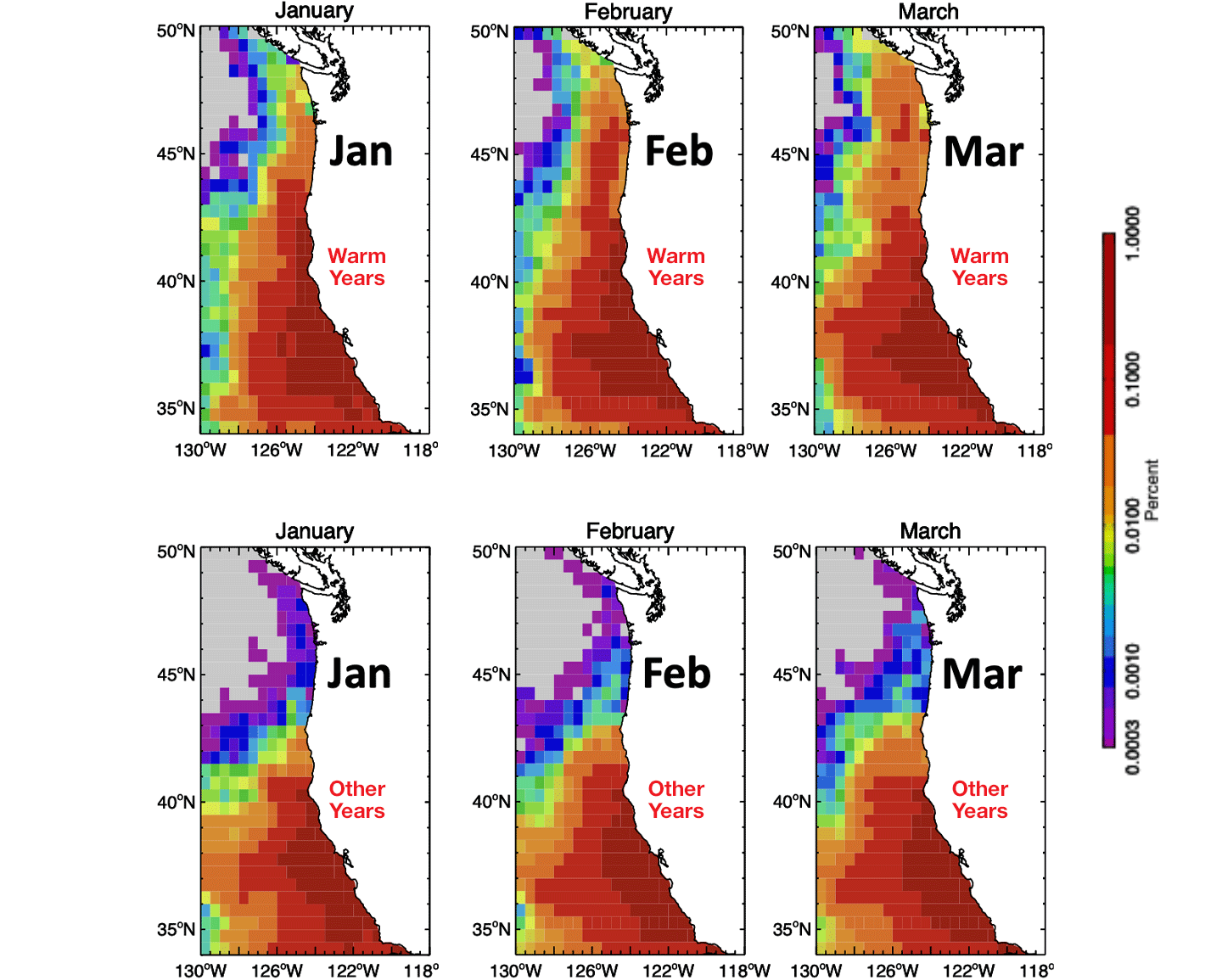
The year-to-year circulation changes along the coast of the western U.S. can have significant impact on the transport of nutrients that affect fisheries. A 2021 article published in the journal Limnology and Oceanography described a study that used ocean currents derived from satellite altimetry to understand the trajectory of water masses from the southern coast of California to the Pacific Northwest. The results show that after a year, subtropical/tropical water masses can reach the Oregon coast from the Southern California Bight (30 °N), and in multiple years from even further south (~26 °N–27 °N) and west. During warmer than average years associated with El Niño Southern Oscillation (1997–1998, 2002–2003, 2004–2005, 2005–2006, 2009–2010, 2014–2015, 2015–2016, 2016–2017), these subtropical/tropical waters masses reached further north compared to other years – see Figure 2. This shift is due to the increase poleward wind stress observed in the California Current. The research team also showed that these tropical warm waters tend to transport “warm water” zooplankton species with a lower fat content. The shift in zooplankton species can impact the young salmon population, which prefer fatty cold-water zooplankton, entering the ocean off the Oregon coast.
Figure 2. This graph shows the density of the water mass traveling northward from the tropics and sub-tropics toward the Pacific Northwest coast during [first three panels] the average of Warm Years (1997–1998, 2002–2003, 2004–2005, 2005–2006, 2009–2010, 2014–2015, 2015–2016, 2016–2017) for January, February, and March, and [last three panels] normal, or Other Years (remaining 15 years excluded from the ‘warm year episodes’ between 1997–2020) for January, February, and March. Off the coast of Oregon, warm water masses are denser during warm years. Image credit: Ted Strub/Oregon State UniversityClosing Plenary Session Highlights
The closing plenary session included discussions, notably about the key points that were addressed during the opening session and splinter sessions.
Cristina Martin-Puig [EUMETSAT] gave a presentation on the definition of the new Geophysical Data Record (GDR) standards (GDR-G) in a multimission context. There are currently 11 altimeters operating with data quality that continues to undergo improvement. While agencies have been coordinating to homogenize processing baselines across missions, a full harmonization between missions was never discussed in detail until now. All agencies are now working in full collaboration to define a set of common standards and the best data processing practices to ensure full harmony between missions.
Conclusion
During the closing session, the OST ST adopted several recommendations – see “Recommendations from the OST Science Team” above for details.
The OST STM expressed strong support for the continuation of the joint Indo–French Satellite AltiKa (SARAL) drifting period for as long as possible, with its altimeter being the most important for future improvements in mean sea surface and gravity.
The OST STM ended with acknowledgements and kudos, several of which refer to recommendations made by the OST ST. The team expressed its appreciation to NASA and CNES for the successful launch and commissioning of the SWOT mission and its revolutionary new wide-swath altimeter for ocean and surface water. Additional acknowledgements can be found in the full OST STM report link referenced in the introduction of this article.
Overall, the meeting fulfilled all of its objectives. It provided a forum for updates on the status of Jason-3, S6MF, and other relevant missions and programs. It also offered detailed analyses of mission observations by the splinter groups. The team concluded that data from the Jason-3 and S6MF altimeters continue to meet the accuracy and availability requirements of the science community.
An international altimetry meeting to celebrate the 30-year anniversary of altimetry will be held in Montpellier, France on September 2–7, 2024.
Acknowledgment: This article is based on the official meeting report, referenced in the introduction of this article and prepared in cooperation with all of the OST STM chairs: Severine Fournier [JPL]; Josh Willis [JPL]; Pascal Bonnefond [Observatoire de Paris, Laboratoire Systèmes de Référence Temps-Espace (SYRTE)/CNES]; Eric Leuliette [NOAA]; Remko Scharroo [EUMETSAT]; and Alejandro Egido [ESA].
Share Details Last Updated May 31, 2024 Related TermsAsian hornets have overwintered in the UK for the first time
Asian hornets have overwintered in the UK for the first time
Every Day is Earth Day for OSI’s Environmental Program
To view this video please enable JavaScript, and consider upgrading to a web browser that supports HTML5 video
In OSI’s Environmental Management Division, we believe every day is Earth Day as we enable environmentally sound mission success through leadership of NASA efforts to comply with environmental laws and advance stewardship and sustainability. See more about what we do for the environment in the Office of Strategic Infrastructure’s (OSI) Earth Day video and nasa.gov/emd where we showcase our programs. Thank you for all you do for protecting our environment.
Time may be an illusion created by quantum entanglement
Time may be an illusion created by quantum entanglement
Moon-mapping could level up for NASA's upcoming Artemis missions. Here's how
Headquarters and Center Chief Counsel Contacts
General Counsel
Iris Lan
Deputy General Counsel
Christine Pham (Acting)
Director of Legal Operations
Bryan R. Diederich (Acting)
Associate General Counsel for Commercial and Intellectual Property Law Practice Group, Headquarters
Karen Reilley
Associate General Counsel for Contracts and Acquisition Integrity Law Practice Group, Headquarters
Scott Barber
Associate General Counsel for General Law Practice Group, Headquarters
Katie Spear
Associate General Counsel for International and Space Law Practice Group, Headquarters
Rebecca Bresnik
Agency Counsel for Ethics, Headquarters
Adam F. Greenstone
Director of the NASA Acquisition Integrity Program (Fraud Remedies) and the Agency Counsel for Acquisition Integrity, Headquarters
Monica Aquino-Thieman
Agency Counsel for Intellectual Property, Headquarters
Trenton Roche
Chief Counsel, Ames Research Center
Dan Hymer (Acting)
Chief Counsel, Armstrong Flight Research Center
Brett Swanson
Chief Counsel, Glenn Research Center
Callista M. Puchmeyer
Chief Counsel, Goddard Space Flight Center
Dave G. Barrett
Chief Counsel, Johnson Space Center
Randall T. Suratt (Acting)
Chief Counsel, Kennedy Space Center
Alex Vinson
Chief Counsel, Langley Research Center
Andrea Z. Warmbier
Chief Counsel, Marshall Space Flight Center
Pam A. Bourque
Chief Counsel, NASA Management Office at JPL
James T. Mahoney
Chief Counsel, NASA Shared Service Center
Ron Bald
Chief Counsel, Stennis Space Center
Ron Bald
General Counsel Organization – Headquarters
General Counsel
Iris Lan
Deputy General Counsel
Christine Pham (Acting)
Director of Legal Operations
Bryan R. Diederich (Acting)
Associate General Counsel for Contracts and Acquisition Integrity Law Practice Group
Scott Barber
Associate General Counsel for General Law Practice Group
Katie Spear
Associate General Counsel for Commercial and Intellectual Property Law Group
Karen M. Reilley
Associate General Counsel for International and Space Law Practice Group
Rebecca Bresnik
Agency Counsel for Ethics
Adam F. Greenstone
Director, Acquisition Integrity Program
Monica Aquino-Thieman
Voyager 1 (and Half Its Instruments) Are Back Online
Voyager 1 is once again returning data from two of four science instruments onboard.
The post Voyager 1 (and Half Its Instruments) Are Back Online appeared first on Sky & Telescope.
Stunning image reveals the intricate structure of supersonic plasma
Stunning image reveals the intricate structure of supersonic plasma
Parachute Engineer Anh Nguyen
“[My proudest moment] was deciding post-college what to do [in my life] and not asking for advice anymore. It’s one of those things where I love asking for advice but sometimes almost too much where I feel like it over influences what I want to do. And in my career, it was the same way. People would keep telling me, ‘Oh, you’re really good at this. You should probably go into this position, or you should try this.’ Now, I sit in certain moments and decide, is this a position I want to take and pursue, or do I really want to do [something else] instead? And then, if I fail or succeed, at least it was my choice.
“So, that moment, that first time [post-college], I realized I had built enough confidence to pursue and do things I wanted to do, whether or not it was something that other people could see me succeed at. I am the type of person where I can succeed at a lot of things because I work hard. I’ll put in my effort, but if I don’t have that interest in it or if it doesn’t align with my current values, I’m not going to get very far in it, and I’m going to be miserable, so I don’t know why I kept trying to entertain that idea.
“These days, I can still take advice from people but not let it totally dictate or control the path that I want to go down or the decisions I want to make because it’s my choice. Much of my path stemmed from my confidence in making the decision, filtering out the judgment of certain people, and realizing that someone might think differently about me this way, but does that really matter?”
– Anh Nguyen, Parachute Engineer, Commercial Crew Program, NASA’s Kennedy Space Center
Image Credit: NASA/Glenn Benson
Interviewer: NASA/Tahira Allen
NASA’s Europa Clipper Unpacks in Florida
Crews rotated to vertical then lifted NASA’s Europa Clipper spacecraft from its protective shipping container after it arrived at the Payload Hazardous Servicing Facility (PHSF) at the agency’s Kennedy Space Center in Florida on May 28.
The spacecraft, which will collect data to help scientists determine if Jupiter’s icy moon Europa could support life, arrived in a United States Air Force C-17 Globemaster III cargo plane at Kennedy’s Launch and Landing Facility on May 23. The hardware traveled more than 2,500 miles from NASA’s Jet Propulsion Lab in Southern California where it was assembled. The team transported Europa Clipper to the PHSF and will perform a number of activities to prepare it for launch, including attaching the high gain antenna, affixing solar arrays to power the spacecraft, and loading propellants that will help guide the spacecraft to its destination.
On board are nine science instruments to gather detailed measurements while Europa Clipper performs approximately 50 close flybys of the Jovian moon. Research suggests an ocean twice the volume of all the Earth’s oceans exists under Europa’s icy crust.
The Europa Clipper spacecraft will launch on a SpaceX Falcon Heavy rocket from NASA Kennedy’s Launch Complex 39A. The launch period opens Thursday, Oct. 10.
1st annual space piracy conference will examine threats of orbital crime and smuggling
Hurricane Season Begins
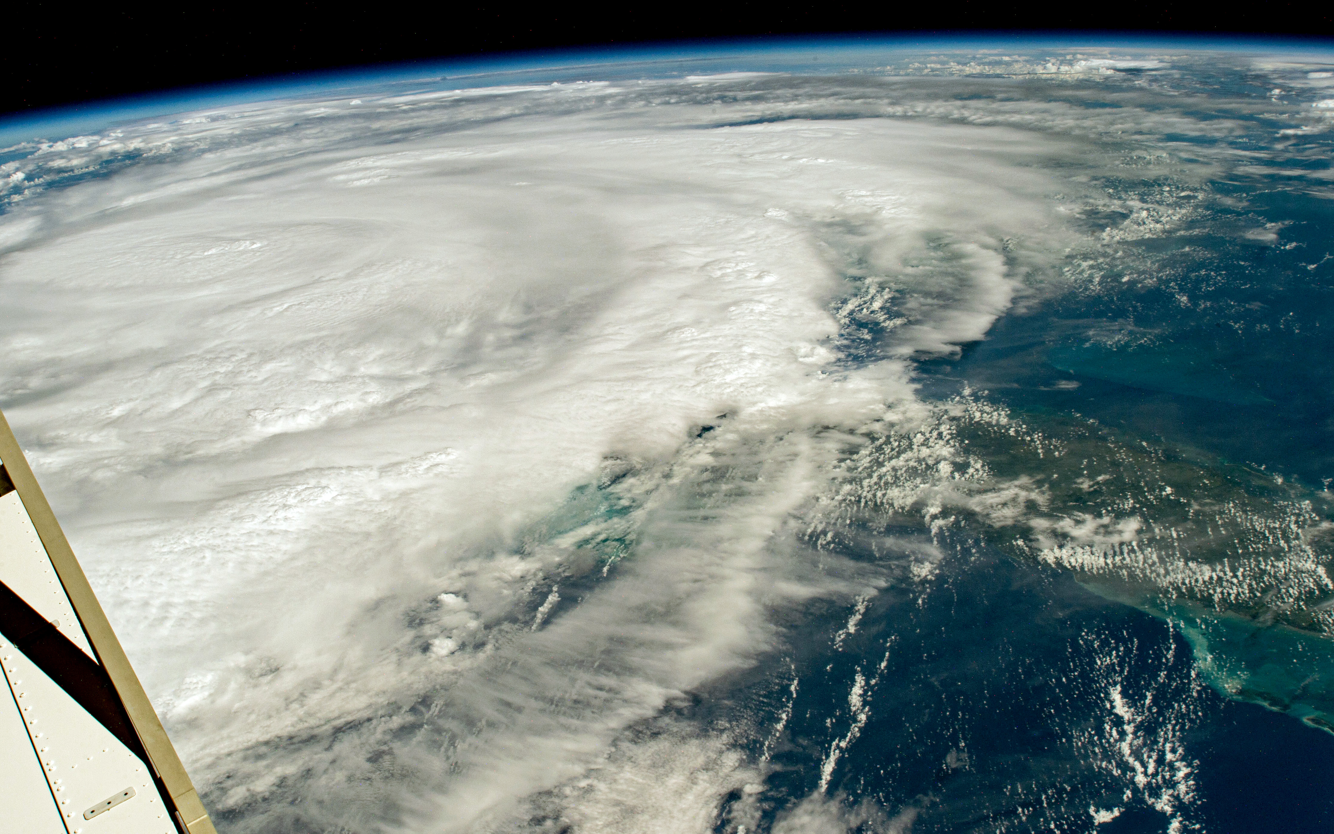
Hurricane Season Begins
June 1 marks the beginning of the 2024 hurricane season in the Atlantic Ocean. NASA observes and studies hurricanes from space, both with views from the space station and with satellites. This vantage point helps scientists understand how climate change impacts hurricanes and learn how communities can better prepare for tropical cyclones in a warmer world.
On Aug. 29, 2023, one of the International Space Station’s external high-definition cameras captured Hurricane Idalia in the Gulf of Mexico. Idalia was a category 1 storm over the Gulf of Mexico with sustained winds of 140 kilometers (85 miles) per hour. As the storm moved north over the Gulf, it quickly strengthened and made landfall over the Big Bend region of Florida on the morning of August 30, 2023, as a category 3 storm.
Image Credit: NASA
Winners Named in NASA Space Tech Art Challenge
2 min read
Preparations for Next Moonwalk Simulations Underway (and Underwater) An illustration created by Luis Rivera Hernandez depicting his interpretation of the Mars Aerial and Ground Global Intelligent Explorer (MAGGIE), a novel aerospace concept study led by Ge-Cheng Zha with Coflow Jet, LLCSpace technology might look a bit different decades from now. The NASA Innovative Advanced Concepts (NIAC) program studies innovative, technically credible, advanced projects that could one day “change the possible” in aerospace. To help people understand what these innovations might look like, NIAC has turned to artists and graphic designers in a global contest to create posters to visualize future technologies under development.
The NASA Space Tech Art Challenge: Imagine Tomorrow received 480 entries from 39 countries. Nine submissions were awarded an even share of the $3,000 prize. The winning submissions from the following individuals depict what the technology might look like, and how and where the concepts might be used in future exploration.
- Rizky Irawan, Indonesia
- Luis Rivera, USA
- Yi Cai, USA
- Holly Pascal, USA
- Beatriz Bronoski, Brazil
- Matthew Turner, United Kingdom
- Joseph Henney, USA
- Bertrand Dano, USA
- Hadley Nicole D., USA
The NASA Tournament Lab – part of the Prizes, Challenges, and Crowdsourcing program within the agency’s Space Technology Mission Directorate – managed the challenge. The NASA Tournament Lab facilitates crowdsourcing to tackle agency science and technology challenges, engaging the global community to seek new ideas and approaches that will ultimately benefit all of humanity. Freelancer.com administered the challenge for NASA.
To learn more about NASA prizes and challenges opportunities, visit:
Facebook logo @NASATechnology @NASA_Technology Keep Exploring Discover More Topics From NASASpace Technology Mission Directorate
NASA Innovative Advanced Concepts
Get Involved
NASA Prizes, Challenges, and Crowdsourcing
Share Details Last Updated May 31, 2024 EditorLoura Hall Related Terms