
Feed aggregator
Is superintelligent AI just around the corner, or just a sci-fi dream?
Is superintelligent AI just around the corner, or just a sci-fi dream?
Air-Conditioning Can Help the Power Grid instead of Overloading It
Switching on air-conditioning during extreme heat doesn’t have to make us feel guilty—it can actually boost power grid reliability and help bring more renewable energy online
Proposed NASA radio probe could use gravity 'lumpiness' to reveal the insides of alien worlds
Week in images: 09-13 June 2025
Week in images: 09-13 June 2025
Discover our week through the lens
How a Tiny Brain Region Guides Generosity
The decision to help a friend or stranger—and the amount of help that one chooses to give—may be powerfully shaped by the brain’s basolateral amygdala
NASA robot digs up simulated moon rocks | Space photo of the day for June 13, 2025
Quantum Computers Simulate Particle 'String Breaking' in a Physics Breakthrough
Physicists are a step closer to using quantum computers for simulations that are beyond the ability of any ordinary computers
Tectonic Plates Can ‘Infect’ One Another with Earth-Shaking Subduction Zones
Evidence from Earth’s deep past suggests dramatic subduction zones can spread like a contagion
Hubble Studies a Spiral’s Supernova Scene
- Hubble Home
- Overview
- Impact & Benefits
- Science
- Observatory
- Team
- Multimedia
- News
- More
2 min read
Hubble Studies a Spiral’s Supernova Scene This NASA/ESA Hubble Space Telescope image features the barred spiral galaxy IC 758. ESA/Hubble & NASA, C. Kilpatrick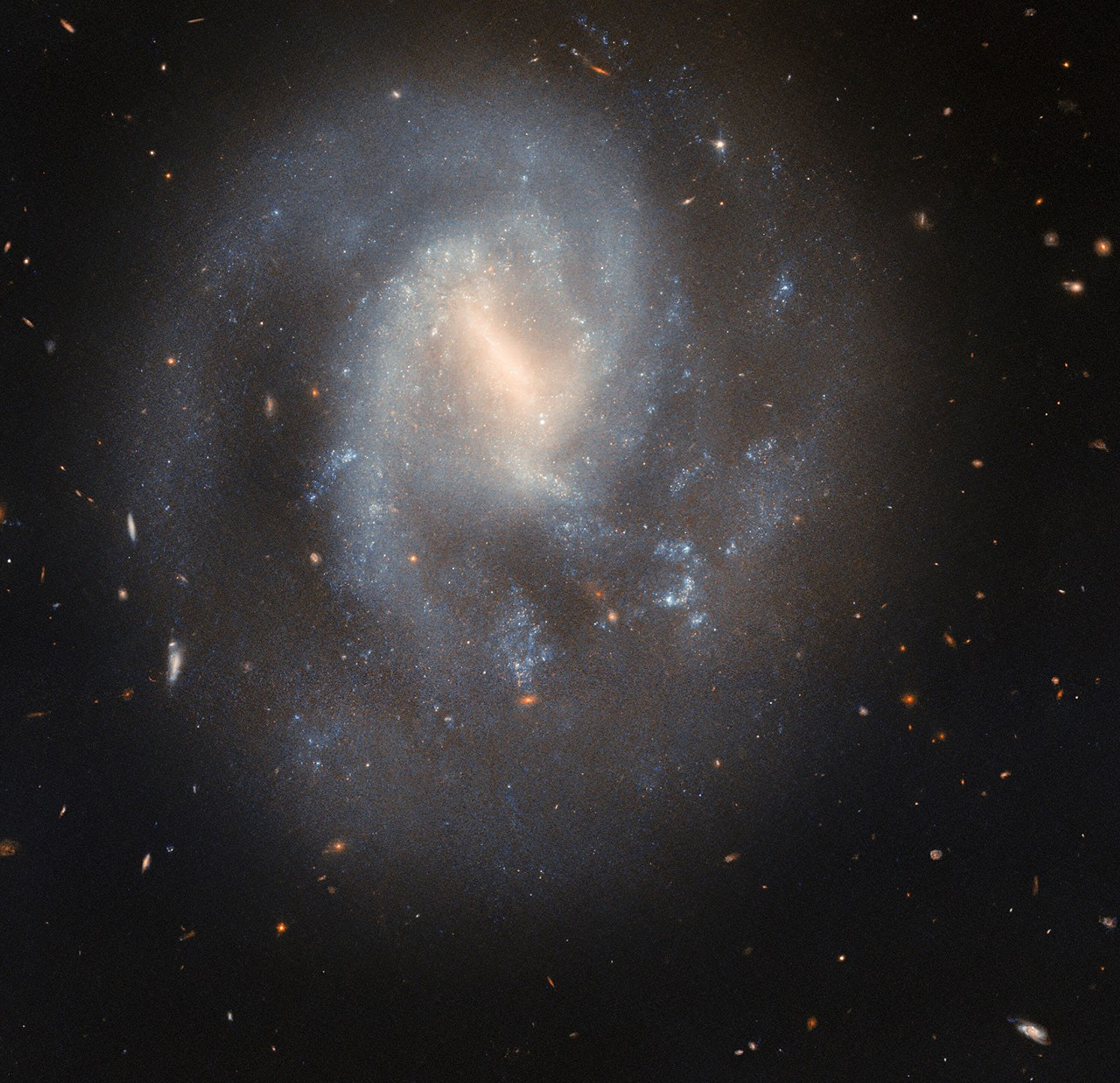
This serene spiral galaxy hides a cataclysmic past. The galaxy IC 758, shown in this NASA/ESA Hubble Space Telescope image, is situated 60 million light-years away in the constellation Ursa Major.
Hubble captured this image in 2023. IC 758 appears peaceful, with its soft blue spiral arms curving gently around its hazy barred center. However, in 1999, astronomers spotted a powerful explosion in this galaxy. The supernova SN 1999bg marked the dramatic end of a star far more massive than the Sun.
Researchers do not know exactly how massive this star was before it exploded, but will use these Hubble observations to measure the masses of stars in SN 1999bg’s neighborhood. These measurements will help them estimate the mass of the star that went supernova. The Hubble data may also reveal whether SN 1999bg’s progenitor star had a companion, which would provide additional clues about the star’s life and death.
A supernova represents more than just the demise of a single star — it’s also a powerful force that can shape its neighborhood. When a massive star collapses, triggering a supernova, its outer layers rebound off its shrunken core. The explosion stirs the interstellar soup of gas and dust out of which new stars form. This interstellar shakeup can scatter and heat nearby gas clouds, preventing new stars from forming, or it can compress them, creating a burst of new star formation. The cast-off layers enrich the interstellar medium, from which new stars form, with heavy elements manufactured in the core of the supernova.
Text Credit: ESA/Hubble
Facebook logo @NASAHubble @NASAHubble Instagram logo @NASAHubbleMedia Contact:
Claire Andreoli (claire.andreoli@nasa.gov)
NASA’s Goddard Space Flight Center, Greenbelt, MD
Since its 1990 launch, the Hubble Space Telescope has changed our fundamental understanding of the universe.
Hubble’s Galaxies
Homing in on Cosmic Explosions
Hubble’s Night Sky Challenge
Hubble Studies a Spiral’s Supernova Scene
- Hubble Home
- Overview
- Impact & Benefits
- Science
- Observatory
- Team
- Multimedia
- News
- More
2 min read
Hubble Studies a Spiral’s Supernova Scene This NASA/ESA Hubble Space Telescope image features the barred spiral galaxy IC 758. ESA/Hubble & NASA, C. KilpatrickThis serene spiral galaxy hides a cataclysmic past. The galaxy IC 758, shown in this NASA/ESA Hubble Space Telescope image, is situated 60 million light-years away in the constellation Ursa Major.
Hubble captured this image in 2023. IC 758 appears peaceful, with its soft blue spiral arms curving gently around its hazy barred center. However, in 1999, astronomers spotted a powerful explosion in this galaxy. The supernova SN 1999bg marked the dramatic end of a star far more massive than the Sun.
Researchers do not know exactly how massive this star was before it exploded, but will use these Hubble observations to measure the masses of stars in SN 1999bg’s neighborhood. These measurements will help them estimate the mass of the star that went supernova. The Hubble data may also reveal whether SN 1999bg’s progenitor star had a companion, which would provide additional clues about the star’s life and death.
A supernova represents more than just the demise of a single star — it’s also a powerful force that can shape its neighborhood. When a massive star collapses, triggering a supernova, its outer layers rebound off its shrunken core. The explosion stirs the interstellar soup of gas and dust out of which new stars form. This interstellar shakeup can scatter and heat nearby gas clouds, preventing new stars from forming, or it can compress them, creating a burst of new star formation. The cast-off layers enrich the interstellar medium, from which new stars form, with heavy elements manufactured in the core of the supernova.
Text Credit: ESA/Hubble
Facebook logo @NASAHubble @NASAHubble Instagram logo @NASAHubbleMedia Contact:
Claire Andreoli (claire.andreoli@nasa.gov)
NASA’s Goddard Space Flight Center, Greenbelt, MD
Since its 1990 launch, the Hubble Space Telescope has changed our fundamental understanding of the universe.
Hubble’s Galaxies
Homing in on Cosmic Explosions
Hubble’s Night Sky Challenge
Mapping Nearby Stars Could Solve a Deep Cosmic Mystery
A near-complete census of our interstellar neighborhood hopes to answer how stars, brown dwarfs and rogue planets form throughout the universe
Invasive Asian Needle Ant’s Sting Is Painful, Can Cause Anaphylaxis
The Asian needle ant looks ordinary, but its sting can be worse than a fire ant’s and can be dangerous for anyone who has experienced anaphylaxis
The Sun's Identity Crisis Solved
The Sun's surface has unveiled a new secret: ultra fine magnetic "curtains" that create striking patterns of bright and dark stripes across the solar photosphere. Thanks to groundbreaking observations from the NSF Daniel K. Inouye Solar Telescope in Hawaii, scientists have captured the sharpest ever images of these previously unseen structures, revealing magnetic field variations at scales as small as 20 kilometres.
Northern lights may be visible in these 18 US states tonight and over the weekend
Djungarian Hamsters Are Unusually Involved Fathers
This Father’s Day, we’re celebrating the unusually involved Djungarian hamster dads