
Feed aggregator
Sun unleashes massive X8.7 solar flare, biggest of current cycle, from super-active monster sunspot (video)
Jupiter's mysterious moon Amalthea spied crossing the Great Red Spot (photo)
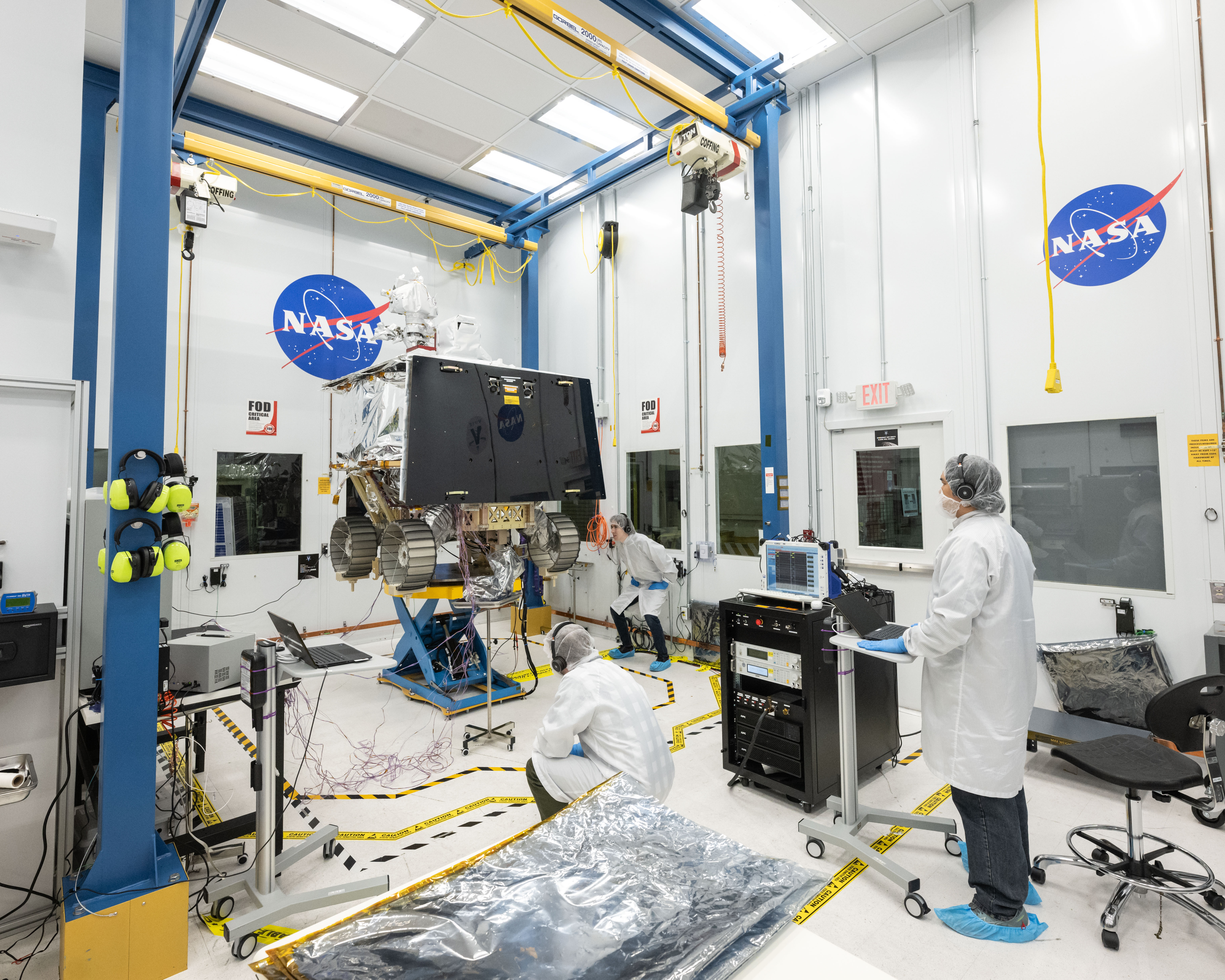
Mission Manager Update: VIPER Rover Approved to Move into Environmental Testing!
While NASA’s VIPER team has been focused on building the flight rover that will go to the South Pole of the Moon, the team has also been making preparations for environmental testing of the rover.
In April, the VIPER team passed a System Test Readiness Review, exploring the readiness of the facilities, procedures, and staff to move into stress-testing the VIPER rover.
These environmental tests are important because they force our rover to experience the conditions it will see during launch, landing, and in the thermal environment of operating at the lunar South Pole. Specifically, acoustic testing will simulate the harsh, vibrational “rock concert” experience of launch, while thermal-vacuum testing will expose VIPER to the hottest and coldest temperatures it will see during the mission, all while operating in the vacuum of space. It’s a tough business, but we have to make sure we’re up for it.
Thanks to this team for the hard efforts to get to this important phase in mission readiness!
Go VIPER!
– Dan Andrews, VIPER Project Manager
Sols 4184-4185: Look Near! Look Far!
3 min read
Sols 4184-4185: Look Near! Look Far! This image was taken by Left Navigation Camera onboard NASA’s Mars rover Curiosity on Sol 4183 (2024-05-13 02:30:29 UTC). NASA/JPL-Caltech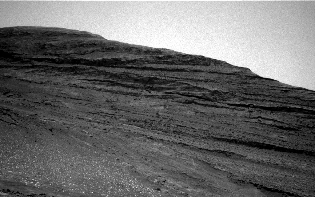
Earth planning date: Monday, May 13, 2024
Today I’ve chosen to show off a spectacular image of ‘Texoli butte,’ but I’m rather biased in my assessment of its beauty because I am currently part of the team studying it. What continues to marvel me is Curiosity’s incredible suite of instruments that can not only help us to assess the rocks around us, but can be used to see very high detail of rocks hundreds of meters away – like Texoli butte – and today we took advantage of those superpowers!
ChemCam is looking far away for us over the next 2 sols, starting with a long-distance RMI of Texoli butte. On the second sol, we are looking at a structure further up Gediz Vallis channel that we won’t be driving up to named ‘Milestone Peak.’ The long-distance observations are really useful in ensuring we can see everything we need to, even if we don’t drive super close. We then take a glimpse between the buttes of Gediz Vallis and above the sulfate-bearing unit we are currently driving in to the yardang unit for the final long-distance RMI of this plan. We can also use Curiosity’s super vision to look at the atmosphere! Over the next 2 sols, Mastcam will measure the amount of dust in the atmosphere in a tau measurement, and Navcam will take a suprahorizon movie as well as being on the lookout for dust devils.
As well as really far away, Curiosity is a specialist at looking and taking measurements of rocks right in front of us. Curiosity will be taking APXS measurements and MAHLI observations on two nearby rocks named ‘Tenaya Lake’ and ‘Buck Lake.’ On the same rock as Buck Lake, ChemCam will be taking a LIBS measurement on a target named ‘Illilouette Falls,’ and another rock a little further away called ‘Redwood Canyon,’ as well as a passive observation on a dark-toned rock named ‘Cox Col.’ Mastcam will document these observations, as well as looking back at the south side of Pinnacle Ridge we have just driven around. In total, Mastcam will spend 1 hour documenting the rocks here at the Gediz Vallis Ridge, including a 15×3 mosaic during an early morning wake-up call at 07:30 to take advantage of the morning light on Mars.
The science team did a wonderful job today documenting all things near and far in this beautiful workspace. As the Keeper of the Plan for the Geology and Mineralogy theme group today, I really enjoyed helping to make this plan a reality, and I can’t wait to see all the fantastic images and data we get back from Mars.
Written by Emma Harris, Graduate Student at Natural History Museum
Share Details Last Updated May 14, 2024 Related Terms Explore More 3 min read Sols 4182-4183: We Reached the South Side of Pinnacle Ridge… What’s Next?Article
4 days ago
3 min read Sols 4180-4181: Imaging fest!
Article
6 days ago
2 min read Sols 4178-4179: The Pinnacle Ridge Scarp
Article
6 days ago
Keep Exploring Discover More Topics From NASA Mars
Mars is no place for the faint-hearted. It’s dry, rocky, and bitter cold. The fourth planet from the Sun, Mars…
All Mars Resources
Rover Basics
Mars Exploration Science Goals
NASA Tests Technology, Practices Artemis Moonwalks in Arizona Desert
To prepare for exploring the Moon during NASA’s Artemis campaign, the agency is conducting a week-long field test in the lunar-like landscape of San Francisco Volcanic Field near Flagstaff, Arizona to practice moonwalk scenarios.
NASA astronauts Kate Rubins and Andre Douglas are serving as the crewmembers and wearing mockup spacesuit systems as they traverse through the desert, completing a variety of technology demonstrations, hardware checkouts and Artemis science-related operations.
During the test, two integrated teams will work together as they practice end-to-end lunar operations. The field team consists of astronauts, NASA engineers, and field experts in the Arizona desert conducting the simulated moonwalks, while a team of flight controllers and scientists at NASA’s Johnson Space Center in Houston monitor and guide their activities.
NASA astronaut Kate Rubins observes a geology sample she collected during a simulated moonwalk. NASA/Josh Valcarcel
“Field tests play a critical role in helping us test all of the systems, hardware, and technology we’ll need to conduct successful lunar operations during Artemis missions,” said Barbara Janoiko, director for the field test at Johnson. “Our engineering and science teams have worked together seamlessly to ensure we are prepared every step of the way for when astronauts step foot on the Moon again.”
The test consists of four simulated moonwalks that follow operations planned for Artemis III and beyond, as well as six advanced technology runs. During the advanced runs, teams will demonstrate technology that may be used for future Artemis missions, such as display and navigation data stream capabilities in the form of a heads-up display using augmented reality or lighting beacons that could help guide crew back to the lander.
Ahead of the field test, the science team at Johnson that was competitively selected and tasked with developing the science objectives for the field test, followed a planning process designed for Artemis missions. Their preparation included generating geologic maps, a list of science questions, and prioritized moonwalk locations for both the primary and back-up “landing sites” for the test.
“During Artemis III, the astronauts will be our science operators on the lunar surface with an entire science team supporting them from here on Earth,” said Cherie Achilles, science officer for the test at NASA’s Goddard Space Flight Center in Greenbelt, Maryland. “This simulation gives us an opportunity to practice conducting geology from afar in real time.”
NASA astronaut Andre Douglas collects soil samples during the first in a series of four simulated moonwalks in Arizona. NASA/Josh Valcarcel
The test will evaluate gaps and challenges associated with lunar South Pole operations, including data collection and communications between the flight control team and science team in Houston for rapid decision-making protocols.
At the conclusion of each simulated moonwalk, the science team, flight control team, crewmembers, and field experts will come together to discuss and record lessons learned. NASA will take these lessons and apply them to operations for NASA’s Artemis missions, commercial vendor development, and other technology development.
This field test is the fifth in the series conducted by the Joint Extravehicular Activity and Human Surface Mobility Test Team led out of Johnson. This test expands on previous field tests the team has performed and is the highest fidelity Artemis moonwalk mission simulation to date.
NASA uses field tests to simulate missions to prepare for deep space destinations. The Arizona desert has been a training ground for lunar exploration since the Apollo era because of the many similarities to the lunar terrain, including craters, faults and volcanic features.
Through Artemis, NASA will land the first woman, the first person of color, and its first international partner astronaut on the Moon, paving the way for long-term lunar exploration and serving as a steppingstone for astronaut missions to Mars.
Learn more about NASA’s Extravehicular Activity and Human Surface Mobility Program:
https://www.nasa.gov/extravehicular-activity-and-human-surface-mobility/
New York Times best-selling author revisits 1986 space shuttle tragedy in 'Challenger' (interview)
Helium leak delays Boeing's 1st Starliner astronaut launch to May 21
How ‘Glowing’ Plants Could Help Scientists Predict Flash Drought
5 min read
Preparations for Next Moonwalk Simulations Underway (and Underwater) In a field in western Kentucky, a machine sprays cover crops to prepare for planting season. NASA scientists are looking to space-based tools to help forecast fast, stealthy droughts responsible for severe agricultural losses in recent years.U.S. Department of Agriculture/Justin Pius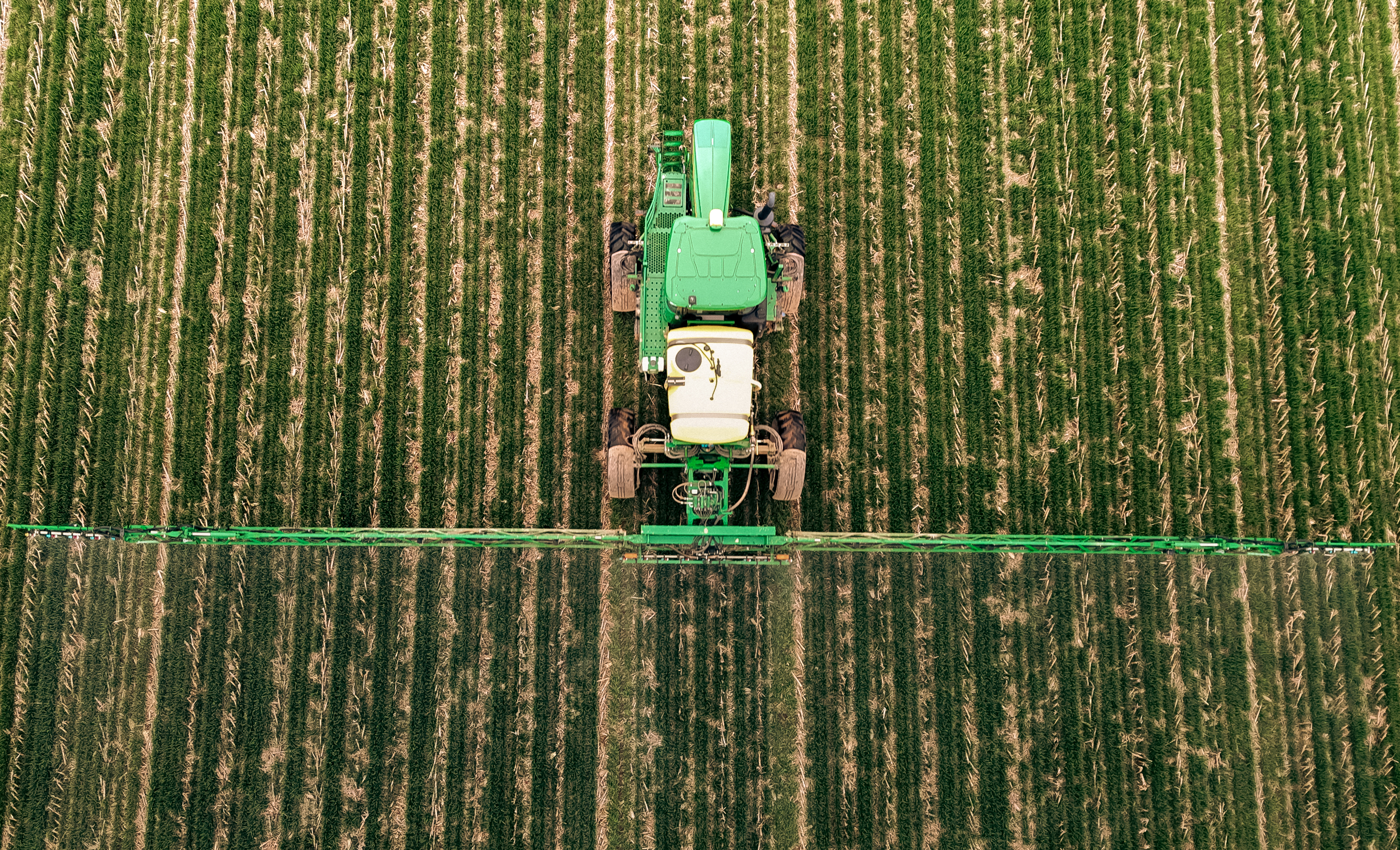
An unusual boost in plant productivity can foreshadow severe soil water loss. NASA satellites are following the clues.
Flaring up rapidly and with little warning, the drought that gripped much of the United States in the summer of 2012 was one of the most extensive the country had seen since the yearslong Dust Bowl of the 1930s. The “flash drought,” stoked by extreme heat that baked the moisture from soil and plants, led to widespread crop failure and economic losses costing more than $30 billion.
While archetypal droughts may develop over seasons, flash droughts are marked by rapid drying. They can take hold within weeks and are tough to predict. In a recent study, a team led by scientists from NASA’s Jet Propulsion Laboratory in Southern California was able to detect signs of flash droughts up to three months before onset. In the future, such advance notice could aid mitigation efforts.
How did they do it? By following the glow.
A Signal Seen From SpaceDuring photosynthesis, when a plant absorbs sunlight to convert carbon dioxide and water into food, its chlorophyll will “leak” some unused photons. This faint glow is called solar-induced fluorescence, or SIF. The stronger the fluorescence, the more carbon dioxide a plant is taking from the atmosphere to power its growth.
To view this video please enable JavaScript, and consider upgrading to a web browser that supports HTML5 video
Growing plants emit a form of light detectable by NASA satellites orbiting hundreds of miles above Earth. Parts of North America appear to glimmer in this visualization, depicting an average year. Gray indicates regions with little or no fluorescence; red, pink, and white indicate high fluorescence.NASA’s Scientific Visualization StudioWhile the glow is invisible to the naked eye, it can be detected by instruments aboard satellites such as NASA’s Orbiting Carbon Obsevatory-2 (OCO-2). Launched in 2014, OCO-2 has observed the U.S. Midwest aglow during the growing season.
The researchers compared years of fluorescence data to an inventory of flash droughts that struck the U.S. between May and July from 2015 to 2020. They found a domino effect: In the weeks and months leading up to a flash drought, vegetation initially thrived as conditions turned warm and dry. The flourishing plants emitted an unusually strong fluorescence signal for the time of year.
But by gradually drawing down the water supply in the soil, the plants created a risk. When extreme temperatures hit, the already low moisture levels plummeted, and flash drought developed within days.
The team correlated the fluorescence measurements with moisture data from NASA’s SMAP satellite. Short for Soil Moisture Active Passive, SMAP tracks changes in soil water by measuring the intensity of natural microwave emissions from Earth’s surface.
The scientists found that the unusual fluorescence pattern correlated extremely well with soil moisture losses in the six to 12 weeks before a flash drought. A consistent pattern emerged across diverse landscapes, from the temperate forests of the Eastern U.S. to the Great Plains and Western shrublands.
For this reason, plant fluorescence “shows promise as a reliable early warning indicator of flash drought with enough lead time to take action,” said Nicholas Parazoo, an Earth scientist at JPL and lead author of the recent study.
Jordan Gerth, a scientist with the National Weather Service Office of Observations who was not involved in the study, said he was pleased to see work on flash droughts, given our changing climate. He noted that agriculture benefits from predictability whenever possible.
While early warning can’t eliminate the impacts of flash droughts, Gerth said, “farmers and ranchers with advanced operations can better use water for irrigation to reduce crop impacts, avoid planting crops that are likely to fail, or plant a different type of crop to achieve the most ideal yield if they have weeks to months of lead time.”
Tracking Carbon EmissionsIn addition to trying to predict flash droughts, the scientists wanted to understand how these impact carbon emissions.
By converting carbon dioxide into food during photosynthesis, plants and trees are carbon “sinks,” absorbing more CO2 from the atmosphere than they release. Many kinds of ecosystems, including farmlands, play a role in the carbon cycle — the constant exchange of carbon atoms between the land, atmosphere, and ocean.
The scientists used carbon dioxide measurements from the OCO-2 satellite, along with advanced computer models, to track carbon uptake by vegetation before and after flash droughts. Heat-stressed plants absorb less CO2 from the atmosphere, so the researchers expected to find more free carbon. What they found instead was a balancing act.
Warm temperatures prior to the onset of flash drought tempted plants to increase their carbon uptake compared to normal conditions. This anomalous uptake was, on average, sufficient to fully offset decreases in carbon uptake due to the hot conditions that ensued. The surprising finding could help improve carbon cycle model predictions.
Celebrating its 10th year in orbit this summer, the OCO-2 satellite maps natural and human-made carbon dioxide concentrations and vegetation fluorescence using three camera-like spectrometers tuned to detect the unique light signature of CO2. They measure the gas indirectly by tracking how much reflected sunlight it absorbs in a given column of air.
The OCO-2 project and SMAP are managed by JPL. Caltech manages JPL for NASA. To read more about them, go to:
and
News Media ContactsJane J. Lee / Andrew Wang
Jet Propulsion Laboratory, Pasadena, Calif.
818-354-0307 / 626-379-6874
jane.j.lee@jpl.nasa.gov / andrew.wang@jpl.nasa.gov
Written by Sally Younger
2024-065
Share Details Last Updated May 14, 2024 Related Terms Explore More 4 min read NASA Teammates Recall Favorite Memories Aboard Flying Laboratory Article 1 day ago 5 min read Meet NASA Women Behind World’s Largest Flying Laboratory Article 2 days ago 6 min read International SWOT Mission Can Improve Flood Prediction Article 1 week ago Keep Exploring Discover Related TopicsMissions
Humans in Space
Climate Change
Solar System
Everything you need to know about semaglutide weight loss drugs
Everything you need to know about semaglutide weight loss drugs
Flu vaccine for children linked to pneumonia risk for their relatives
Flu vaccine for children linked to pneumonia risk for their relatives
NASA’s DC-8 to Fly Low Altitude Over Pocatello, Idaho, for Final Flight
2 min read
Preparations for Next Moonwalk Simulations Underway (and Underwater) NASA’s DC-8 aircraft.NASANASA’s DC-8 aircraft will fly at low altitude over Pocatello, Idaho, and surrounding areas during its final flight from NASA’s Armstrong Flight Research Center in Edwards, California, to Idaho State University.
After 37 years of successful airborne science missions, the DC-8 aircraft is retiring at Idaho State University, where it will be used to train future aircraft technicians by providing hands-on experience at the college’s Aircraft Maintenance Technology Program.
Residents in the areas below will see and hear the aircraft as it flies to its new and final home.
Where: Pocatello, Idaho (and surrounding areas).
When: Wednesday, May 15, between 2:00-2:30 PM.
Additional details: All flyovers are conducted at a safe altitude without harm to public, wildlife, or infrastructure. Jet aircraft are loud and those with sensitivity to loud noises should be aware of the flyover window.
To follow along real-time with the DC-8’s flight path, visit https://airbornescience.nasa.gov/tracker/#!/status/list, or:
- Go to www.FlightAware.com , or download the app.
- Type the aircraft tail number in the search bar: N817NA.
- Follow the aircraft in real time!
Learn more:
- About the DC-8 aircraft: https://www.nasa.gov/centers-and-facilities/armstrong/dc-8-aircraft/.
- About the DC-8’s retirement: https://www.nasa.gov/image-article/nasas-dc-8-completes-final-mission-set-to-retire/.
-end-
For more information, contact:
Erica Heim
NASA’s Armstrong Flight Research Center, Edwards, California
650-499-9053
erica.heim@nasa.gov
Earth planning date: Monday, May 13, 2024 Today I’ve chosen to show off a spectacular image…
Article 2 hours ago Keep Exploring Discover More Topics From NASAArmstrong Flight Research Center
Armstrong Science Projects
Aircraft Flown at Armstrong
Science in the Air
Giant 'rogue waves' of invisible matter might be disrupting the orbits of stars, new study hints
NASA’s DC-8 to Fly Low Altitude Over San Jose, California, for Final Flight
2 min read
Preparations for Next Moonwalk Simulations Underway (and Underwater) NASA’s DC-8 aircraft.NASANASA’s DC-8 aircraft will fly at low altitude over San Jose and surrounding areas during its final flight from NASA’s Armstrong Flight Research Center in Edwards, California, to Idaho State University in Pocatello, Idaho.
After 37 years of successful airborne science missions, the DC-8 aircraft is retiring at Idaho State University, where it will be used to train future aircraft technicians by providing hands-on experience at the college’s Aircraft Maintenance Technology Program.
Residents in the areas below will see and hear the aircraft as it flies to its new and final home.
Where: San Jose, Mountain View, California (and surrounding areas).
When: Wednesday, May 15, between 11:00-11:30 AM.
Additional details: All flyovers are conducted at a safe altitude without harm to public, wildlife, or infrastructure. Jet aircraft are loud and those with sensitivity to loud noises should be aware of the flyover window.
To follow along real-time with the DC-8’s flight path, visit https://airbornescience.nasa.gov/tracker/#!/status/list, or:
- Go to www.FlightAware.com , or download the app.
- Type the aircraft tail number in the search bar: N817NA.
- Follow the aircraft in real time!
Learn more:
- About the DC-8 aircraft: https://www.nasa.gov/centers-and-facilities/armstrong/dc-8-aircraft/.
- About the DC-8’s retirement: https://www.nasa.gov/image-article/nasas-dc-8-completes-final-mission-set-to-retire/.
-end-
For more information, contact:
Erica Heim
NASA’s Armstrong Flight Research Center, Edwards, California
650-499-9053
erica.heim@nasa.gov
Earth planning date: Monday, May 13, 2024 Today I’ve chosen to show off a spectacular image…
Article 2 hours ago Keep Exploring Discover More Topics From NASAArmstrong Flight Research Center
Armstrong Science Projects
Aircraft Flown at Armstrong
Science in the Air
We are about to hear echoes in the fabric of space for the first time
We are about to hear echoes in the fabric of space for the first time
NASA’s DC-8 to Fly Low Altitude Over Palmdale, California, for Final Flight
2 min read
Preparations for Next Moonwalk Simulations Underway (and Underwater) NASA’s DC-8 aircraft.NASANASA’s DC-8 aircraft will fly at low altitude over Palmdale, California, and surrounding areas during its final flight from NASA’s Armstrong’s Flight Research Center in Edwards, California, to Idaho State University in Pocatello, Idaho.
After 37 years of successful airborne science missions, the DC-8 aircraft is retiring at Idaho State University, where it will be used to train future aircraft technicians by providing hands-on experience at the college’s Aircraft Maintenance Technology Program.
Residents in the areas below will see and hear the aircraft as it flies to its new and final home.
Where: Palmdale, California; Edwards, California (and surrounding areas).
When: Wednesday, May 15, between 10:00-10:30 AM.
Additional details: All flyovers are conducted at a safe altitude without harm to public, wildlife, or infrastructure. Jet aircraft are loud and those with sensitivity to loud noises should be aware of the flyover window.
To follow along real-time with the DC-8’s flight path, visit:
https://airbornescience.nasa.gov/tracker/#!/status/list , or:
- Go to www.FlightAware.com or download the app.
- Type the aircraft tail number in the search bar: N817NA.
- Follow the aircraft in real time!
Learn more:
- About the DC-8 aircraft: https://www.nasa.gov/centers-and-facilities/armstrong/dc-8-aircraft/.
- About the DC-8’s retirement: https://www.nasa.gov/image-article/nasas-dc-8-completes-final-mission-set-to-retire/.
-end-
For more information, contact:
Erica Heim
NASA’s Armstrong Flight Research Center, Edwards, California
650-499-9053
erica.heim@nasa.gov
Earth planning date: Monday, May 13, 2024 Today I’ve chosen to show off a spectacular image…
Article 2 hours ago Keep Exploring Discover More Topics From NASAArmstrong Flight Research Center
Armstrong Science Projects
Aircraft Flown at Armstrong
Science in the Air