
Feed aggregator
Have we finally worked out how Venus flytraps snap shut?
NASA Robotic Tech Demo Will Advance Prototype Gamma-Ray Detectors
4 min read
NASA Robotic Tech Demo Will Advance Prototype Gamma-Ray DetectorsA new type of gamma-ray sensor developed by NASA, called AstroPix, will take part in a robotic arm demonstration on the agency’s upcoming Fly Foundational Robots mission, set to launch in late 2027.
Gamma rays are the highest-energy form of light. Scientists observe them coming from events like lightning in Earth’s atmosphere, powerful solar flares from our Sun, and cosmic collisions in distant galaxies. The sensors on the AstroPix technology demonstration are designed to measure gamma rays between 20,000 and 700,000 electron volts. For comparison, visible light’s energy falls between 2 and 3 electron volts.
Current NASA missions, including the Fermi Gamma-ray Space Telescope and Neil Gehrels Swift Observatory, also observe gamma rays, including those with even higher energies.
But for energies between 500,000 to 1 million electron volts, existing detectors are less sensitive. This range is where many powerful explosions called gamma-ray bursts shine the brightest. It’s also where astronomers expect to see the strongest glow from the most massive and distant active galaxies powered by black holes. By stacking AstroPix detectors in future missions, scientists could bridge this gap and improve observations of these cosmic objects to better understand the processes that create and drive them.
“The Fly Foundational Robots spacecraft is also a technology demonstration, so the projects were a good fit for each other,” said Dan Violette, an AstroPix team member and post-doctoral fellow at NASA’s Goddard Space Flight Center in Greenbelt, Maryland. “We need to thoroughly test AstroPix’s performance before we can use the sensors in future science missions. We’ve flown comparable technologies on a scientific balloon mission, and the current prototype eventually will be part of a sounding rocket payload. Many of those flight opportunities only reach near space, though. It’s not often that technology demonstrations like ours can find a ride into orbit.”
Each AstroPix chip has four silicon pixel gamma-ray detectors. Each of these detectors incorporates 1,225 pixels. AstroPix detectors, which are developed by NASA’s Goddard Space Flight Center in Greenbelt, Md., function similarly to the sensors in cellphone cameras except they are sensitive to gamma-ray light. Image courtesy of Argonne National Laboratory
Each AstroPix chip contains four silicon pixel gamma-ray detectors, and each detector incorporates 1,225 pixels. The chips function similarly to the sensors in cell phone cameras.
The AstroPix Satellite Technology dEmonstration Payload, also known as A-STEP, will be hosted within the Fly Foundational Robots mission’s Orbital Replacement Unit, a movable module built by Rocket Lab Robotics. Rocket Lab Robotics also will provide a robotic arm that will pick up and reposition the unit during flight and perform in-orbit operations as part of a robotic servicing demonstration. The A-STEP payload will collect its data following the repositioning. Astro Digital will provide the spacecraft.
The Orbital Replacement Unit was designed to support power and data interfaces for a payload, but the original plan called for the robotic arm to reposition the module without one. As mission development progressed, however, the Fly Foundational Robots team identified an opportunity to further maximize the mission’s value by integrating an additional technology demonstration that could fit within the 11.8-inch (30-centimeter) cube.
“The unit already had the volume, power, and data needed to support the AstroPix team’s design,” said Bo Naasz, senior technical lead, In-space Servicing, Assembly, and Manufacturing in the Space Technology Mission Directorate at NASA Headquarters in Washington. “One of our major goals with Fly Foundational Robots is to demonstrate robotic changeout of payloads in orbit, enabling upgrades or improvements to satellites and space instruments at a fraction of the cost of a full mission. Allowing AstroPix to complete its own technology demonstration in orbit is a bonus.”
NASA’s Fly Foundational Robots mission will be hosted aboard a spacecraft provided by Astro Digital of Littleton, Colo., as shown in this artist’s concept. The robotic arm, provided by Motiv Space Systems in Pasadena, Calif., will perform a technology demonstration in orbit, including picking up and moving a small box containing the agency’s AstroPix gamma-ray sensors. Rocket Lab Robotics
The AstroPix team is working to deliver their hardware this September, and it will be integrated into the Fly Foundational Robots payload before final integration onto the spacecraft. The Orbital Replacement Unit will hold the chips and all the associated electronics needed to provide power, and collect and transmit data during flight.
NASA’s Fly Foundational Robots mission is funded through the Space Technology Mission Directorate’s ISAM portfolio, managed at NASA Goddard. Rocket Lab Robotics will supply the mission’s robotic arm system through a NASA Small Business Innovation Research Phase III award. Astro Digital will host the orbital flight test of the arm through NASA’s Flight Opportunities program, managed at NASA’s Armstrong Flight Research Center in Edwards, California. The development of AstroPix was supported by NASA’s Astrophysics Division in the Science Mission Directorate at NASA Headquarters, through the agency’s Astrophysics Research and Analysis Program, and funded through the Nancy Grace Roman Technology Fellowship.
To learn more, visit:
By Jeanette Kazmierczak
Goddard Space Flight Center, Greenbelt, Md.
NASA Robotic Tech Demo Will Advance Prototype Gamma-Ray Detectors
4 min read
NASA Robotic Tech Demo Will Advance Prototype Gamma-Ray DetectorsA new type of gamma-ray sensor developed by NASA, called AstroPix, will take part in a robotic arm demonstration on the agency’s upcoming Fly Foundational Robots mission, set to launch in late 2027.
Gamma rays are the highest-energy form of light. Scientists observe them coming from events like lightning in Earth’s atmosphere, powerful solar flares from our Sun, and cosmic collisions in distant galaxies. The sensors on the AstroPix technology demonstration are designed to measure gamma rays between 20,000 and 700,000 electron volts. For comparison, visible light’s energy falls between 2 and 3 electron volts.
Current NASA missions, including the Fermi Gamma-ray Space Telescope and Neil Gehrels Swift Observatory, also observe gamma rays, including those with even higher energies.
But for energies between 500,000 to 1 million electron volts, existing detectors are less sensitive. This range is where many powerful explosions called gamma-ray bursts shine the brightest. It’s also where astronomers expect to see the strongest glow from the most massive and distant active galaxies powered by black holes. By stacking AstroPix detectors in future missions, scientists could bridge this gap and improve observations of these cosmic objects to better understand the processes that create and drive them.
“The Fly Foundational Robots spacecraft is also a technology demonstration, so the projects were a good fit for each other,” said Dan Violette, an AstroPix team member and post-doctoral fellow at NASA’s Goddard Space Flight Center in Greenbelt, Maryland. “We need to thoroughly test AstroPix’s performance before we can use the sensors in future science missions. We’ve flown comparable technologies on a scientific balloon mission, and the current prototype eventually will be part of a sounding rocket payload. Many of those flight opportunities only reach near space, though. It’s not often that technology demonstrations like ours can find a ride into orbit.”
Each AstroPix chip has four silicon pixel gamma-ray detectors. Each of these detectors incorporates 1,225 pixels. AstroPix detectors, which are developed by NASA’s Goddard Space Flight Center in Greenbelt, Md., function similarly to the sensors in cellphone cameras except they are sensitive to gamma-ray light. Image courtesy of Argonne National LaboratoryEach AstroPix chip contains four silicon pixel gamma-ray detectors, and each detector incorporates 1,225 pixels. The chips function similarly to the sensors in cell phone cameras.
The AstroPix Satellite Technology dEmonstration Payload, also known as A-STEP, will be hosted within the Fly Foundational Robots mission’s Orbital Replacement Unit, a movable module built by Rocket Lab Robotics. Rocket Lab Robotics also will provide a robotic arm that will pick up and reposition the unit during flight and perform in-orbit operations as part of a robotic servicing demonstration. The A-STEP payload will collect its data following the repositioning. Astro Digital will provide the spacecraft.
The Orbital Replacement Unit was designed to support power and data interfaces for a payload, but the original plan called for the robotic arm to reposition the module without one. As mission development progressed, however, the Fly Foundational Robots team identified an opportunity to further maximize the mission’s value by integrating an additional technology demonstration that could fit within the 11.8-inch (30-centimeter) cube.
“The unit already had the volume, power, and data needed to support the AstroPix team’s design,” said Bo Naasz, senior technical lead, In-space Servicing, Assembly, and Manufacturing in the Space Technology Mission Directorate at NASA Headquarters in Washington. “One of our major goals with Fly Foundational Robots is to demonstrate robotic changeout of payloads in orbit, enabling upgrades or improvements to satellites and space instruments at a fraction of the cost of a full mission. Allowing AstroPix to complete its own technology demonstration in orbit is a bonus.”
NASA’s Fly Foundational Robots mission will be hosted aboard a spacecraft provided by Astro Digital of Littleton, Colo., as shown in this artist’s concept. The robotic arm, provided by Motiv Space Systems in Pasadena, Calif., will perform a technology demonstration in orbit, including picking up and moving a small box containing the agency’s AstroPix gamma-ray sensors. Rocket Lab RoboticsThe AstroPix team is working to deliver their hardware this September, and it will be integrated into the Fly Foundational Robots payload before final integration onto the spacecraft. The Orbital Replacement Unit will hold the chips and all the associated electronics needed to provide power, and collect and transmit data during flight.
NASA’s Fly Foundational Robots mission is funded through the Space Technology Mission Directorate’s ISAM portfolio, managed at NASA Goddard. Rocket Lab Robotics will supply the mission’s robotic arm system through a NASA Small Business Innovation Research Phase III award. Astro Digital will host the orbital flight test of the arm through NASA’s Flight Opportunities program, managed at NASA’s Armstrong Flight Research Center in Edwards, California. The development of AstroPix was supported by NASA’s Astrophysics Division in the Science Mission Directorate at NASA Headquarters, through the agency’s Astrophysics Research and Analysis Program, and funded through the Nancy Grace Roman Technology Fellowship.
To learn more, visit:
By Jeanette Kazmierczak
Goddard Space Flight Center, Greenbelt, Md.
El Niño has started and the weather could get weird
El Niño has started and the weather could get weird
Children’s zip codes change their brains, new study finds
Children living in areas with low socioeconomic opportunities have more tired and stressed brains, a new study finds
See the hidden fungal network so big it could stretch to Proxima Centauri and back
Researchers have created the first high-resolution global map of the extent of one of Earth’s largest—and least visible—living networks
Meet REMORA: The Autonomous Space Fleet Built to Tag and Track Asteroids
To truly understand what an asteroid is made up of, we need to send a probe to it. Remote sensing from ground-based telescopes, or even orbiting observatories, and only do so much. A new white paper submitted to the UK Space Agency’s 2035 Space Frontiers programme, pitches just such a mission architecture. Called the REndezvous Mission for Orbital Reconstruction of Asteroids (REMORA), the plan calls for a swarm of autonomous CubeSats to tag, track, and characterize multiple near-Earth asteroids.
Soccer Meets Space Science
Watch the Moon Occult Venus in the Daytime for North America on June 17th
If you’re like us, you’ve been following the close conjunction of Jupiter and Venus in the June dusk sky. Next week, the Moon enters the evening scene, and actually occults (passes in front of) the planet Venus in what promises to be one of the top skywatching events for 2026.
Soccer Meets Space Science
A soccer ball floats in microgravity in this March 2, 2026, picture from the International Space Station. The space station crew tested soccer balls to study how internal mass affects motion and stability in microgravity. The findings have improved understanding of how embedded technologies, including match-ball sensors, can influence performance during play.
Through research aboard the International Space Station and technology developed for exploration, NASA continues to demonstrate how discoveries made for space can benefit people on Earth—including athletes and fans participating in the world’s most popular sport.
Image credit: NASA
NASA’s Career Technical Education Day Highlights Technical Careers
3 min read
Preparations for Next Moonwalk Simulations Underway (and Underwater) Students participate in a hands-on robotics demonstration during Career Technical Education Day at NASA’s Langley Research Center in Hampton, Virginia. NASA/Mark Knopp
At NASA, remaining a global leader in exploration and innovation includes having a skilled
and dedicated workforce. Technicians play a critical role in advancing the agency’s
research and missions, applying hands-on expertise across engineering, fabrication,
electronics, and countless other technical fields.
To help cultivate the next generation of technical talent, NASA’s Office of STEM Engagement
hosted Career Technical Education Day recently at NASA’s Langley Research Center in
Hampton, Virginia. One hundred high school and community college students from Virginia
and North Carolina attended, eager to explore the technical career paths that help drive
NASA’s work.
“Many students picture NASA as only astronauts or engineers and therefore never consider
a career at NASA to be within their reach,” said Bonnie Murray, lead for the Office of STEM
Engagement at NASA Langley. “Bringing students from local career and technical
education programs to Langley allows them the opportunity to see technicians at work,
hear the pathways those technicians followed, and understand how the skills they are
developing in their related classes have a place in the NASA workforce.”
The event opened with remarks from NASA Langley’s Steve Gayle, who traced his path from
an engineering technician co-op in the center’s Fabrication Division and a graduate of
Langley’s Engineering Technician Apprentice Program to his current role as acting
associate director. Gayle encouraged students to embrace challenges, think critically, stay
curious, and create their own opportunities as they pursue their career goals.
“We need young, bright minds,” Gayle said. “At NASA, we rely on skilled hands-on
professionals — technicians who operate our wind tunnels, apply their skills in our
fabrication shops, and use their electronics knowledge to design, test, and build critical
systems.”
Throughout the day, students toured several of Langley’s world-class facilities, including
the historic Landing and Impact Research Facility and one of the center’s wind tunnels. At
each stop, they received a behind-the-scenes look at the spaces where NASA technicians
build, test, and refine the tools and technologies that support the agency’s missions. The
technicians spoke with students about their work, their career paths, and the skills needed
to excel in technical roles.
Hands-on demonstrations and interactive activities lead by NASA technicians and
aerospace industry partners helped students connect their classroom experience with
real-world applications. Whether observing fabrication techniques, seeing instrumentation
up close, or engaging with engineering demonstrations, participants experienced how
STEM and technical skills directly translate into meaningful careers.
“Through events such as this, NASA seeks to prepare students for aerospace careers
through experiences and investments that strengthen research capacity, build technical
expertise, and expand reach in alignment with agency missions and needs,” Murray said.
The event ended with a career panel moderated by NASA astronaut Joe Acaba, associate
director of mission and strategy at NASA’s Johnson Space Center in Houston and former
math and science teacher. The panel featured four Langley technician apprentices who
shared insights into their roles and the value of strong foundational skills in technical
fields.
“A basic grasp of how software, systems, and even everyday items function goes a long way
as you progress in your technician journey,” said Wyatt Healy, mechanical engineering
technician apprentice at NASA Langley. “When you have those fundamentals down,
learning the more advanced concepts becomes much easier. It doesn’t happen overnight,
but with a strong foundation, the sky is the limit.”
By connecting students with NASA professionals, facilities, and hands-on experiences, the
event showcased a broad range of opportunities available in technical careers. It also
underscored NASA’s commitment to building a strong, skilled workforce equipped to
support the agency’s mission and tackle the challenges of tomorrow.
For more information about opportunities to connect students with NASA’s mission, work, and people, visit:
https://www.nasa.gov/learning-resources
Brittny McGraw
NASA Langley Research Center
Missions
Humans in Space
Climate Change
Solar System
NASA’s Career Technical Education Day Highlights Technical Careers
3 min read
Preparations for Next Moonwalk Simulations Underway (and Underwater) Students participate in a hands-on robotics demonstration during Career Technical Education Day at NASA’s Langley Research Center in Hampton, Virginia. NASA/Mark KnoppAt NASA, remaining a global leader in exploration and innovation includes having a skilled
and dedicated workforce. Technicians play a critical role in advancing the agency’s
research and missions, applying hands-on expertise across engineering, fabrication,
electronics, and countless other technical fields.
To help cultivate the next generation of technical talent, NASA’s Office of STEM Engagement
hosted Career Technical Education Day recently at NASA’s Langley Research Center in
Hampton, Virginia. One hundred high school and community college students from Virginia
and North Carolina attended, eager to explore the technical career paths that help drive
NASA’s work.
“Many students picture NASA as only astronauts or engineers and therefore never consider
a career at NASA to be within their reach,” said Bonnie Murray, lead for the Office of STEM
Engagement at NASA Langley. “Bringing students from local career and technical
education programs to Langley allows them the opportunity to see technicians at work,
hear the pathways those technicians followed, and understand how the skills they are
developing in their related classes have a place in the NASA workforce.”
The event opened with remarks from NASA Langley’s Steve Gayle, who traced his path from
an engineering technician co-op in the center’s Fabrication Division and a graduate of
Langley’s Engineering Technician Apprentice Program to his current role as acting
associate director. Gayle encouraged students to embrace challenges, think critically, stay
curious, and create their own opportunities as they pursue their career goals.
“We need young, bright minds,” Gayle said. “At NASA, we rely on skilled hands-on
professionals — technicians who operate our wind tunnels, apply their skills in our
fabrication shops, and use their electronics knowledge to design, test, and build critical
systems.”
Throughout the day, students toured several of Langley’s world-class facilities, including
the historic Landing and Impact Research Facility and one of the center’s wind tunnels. At
each stop, they received a behind-the-scenes look at the spaces where NASA technicians
build, test, and refine the tools and technologies that support the agency’s missions. The
technicians spoke with students about their work, their career paths, and the skills needed
to excel in technical roles.
Hands-on demonstrations and interactive activities lead by NASA technicians and
aerospace industry partners helped students connect their classroom experience with
real-world applications. Whether observing fabrication techniques, seeing instrumentation
up close, or engaging with engineering demonstrations, participants experienced how
STEM and technical skills directly translate into meaningful careers.
“Through events such as this, NASA seeks to prepare students for aerospace careers
through experiences and investments that strengthen research capacity, build technical
expertise, and expand reach in alignment with agency missions and needs,” Murray said.
The event ended with a career panel moderated by NASA astronaut Joe Acaba, associate
director of mission and strategy at NASA’s Johnson Space Center in Houston and former
math and science teacher. The panel featured four Langley technician apprentices who
shared insights into their roles and the value of strong foundational skills in technical
fields.
“A basic grasp of how software, systems, and even everyday items function goes a long way
as you progress in your technician journey,” said Wyatt Healy, mechanical engineering
technician apprentice at NASA Langley. “When you have those fundamentals down,
learning the more advanced concepts becomes much easier. It doesn’t happen overnight,
but with a strong foundation, the sky is the limit.”
By connecting students with NASA professionals, facilities, and hands-on experiences, the
event showcased a broad range of opportunities available in technical careers. It also
underscored NASA’s commitment to building a strong, skilled workforce equipped to
support the agency’s mission and tackle the challenges of tomorrow.
For more information about opportunities to connect students with NASA’s mission, work, and people, visit:
https://www.nasa.gov/learning-resources
Brittny McGraw
NASA Langley Research Center
Missions
Humans in Space
Climate Change
Solar System
Astrochemical Model Digs Into the Universe's Missing Sulfur
Sulfur is one of the most abundant elements in the universe. If you peer into a diffuse interstellar cloud, you find loads of it - about the amount expected based on fusion patterns of the stars it was born in. However, if you look at a dense, cold, molecular cloud - the kind where those stars actually form - it seems like 99% of the sulfur that is expected to be there is missing. Scientists have puzzled over this “missing sulfur problem” for decades, though a leading theory is that the element hides on icy dust grains making it hard to detect. A new paper published in Astronomy & Astrophysics from the Max Planck Institute for Extraterrestrial Physics and the Centro de Astrobiologia describes a new computer simulation model that they aimed to support the interpretation of laboratory results and test our current understanding of sulfur evolution in interstellar ices.
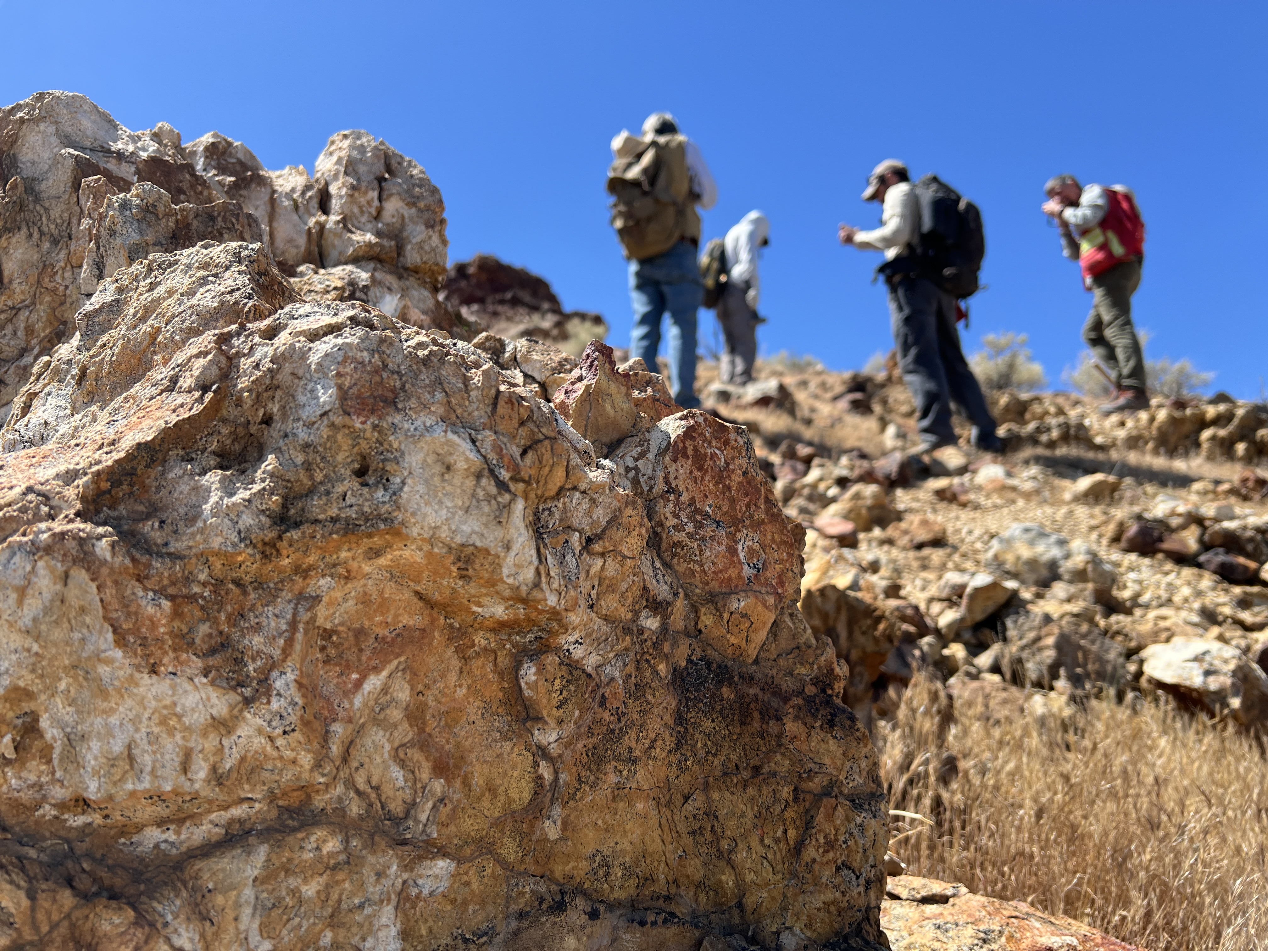
NASA, USGS Scientists Go Rock Hounding in California’s High Desert
Equipped with rock picks and hand lenses, a team of geoscientists deployed to the Mojave Desert recently to investigate a tantalizing “fingerprint” detected by a NASA sensor. Their target: a cache of topaz hiding in plain sight.
The geologists weren’t searching for gem-grade treasure. Rather, the presence of topaz could hint at a more valuable deposit below of something known as porphyry copper.
One of the world’s primary sources of copper, these deposits are left behind when magma and hot water from deep underground course through Earth’s crust, chemically transforming the surrounding rock. This tends to occur where one tectonic plate dives below another, known as a subduction zone, such as the North American Cordillera, which stretches from the Canadian Rockies to western Mexico.
California’s high desert stretches below a bright spring sky in April 2026. NASA and USGS scientists are using airborne remote sensing to home in on potential sources of critical minerals here and across the Western U.S.NASA/JPL-Caltech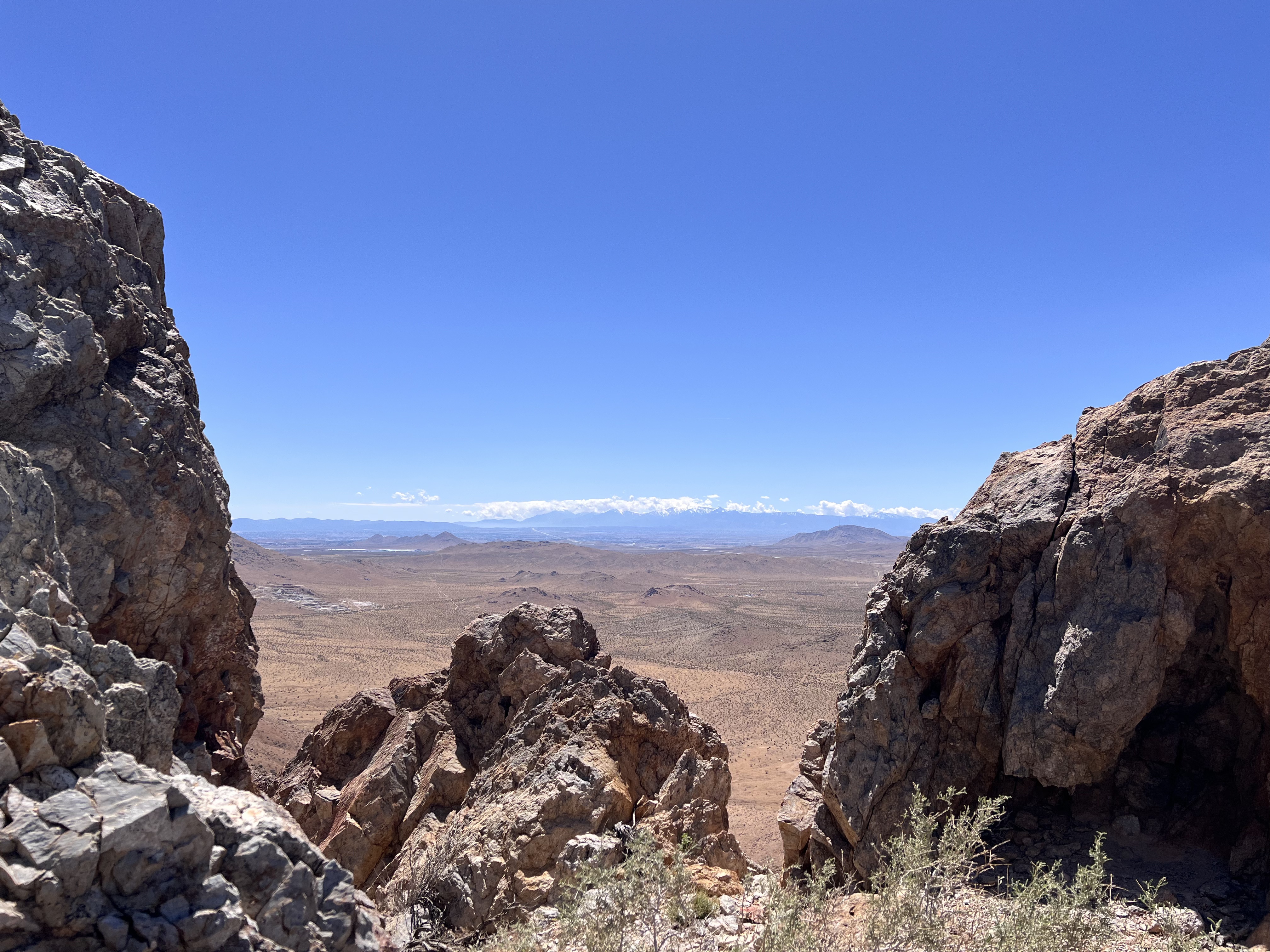
In addition to copper — the third most used metal in the world after steel and aluminum — the deposits can hold other critical minerals like molybdenum and tellurium, which are used in everything from steelmaking to solar panels. Finding the deposits isn’t easy. Geologists look for topaz because it forms under the same volcanic conditions.
For the team in the Mojave, the goal was to collect more evidence. That would require boots on the ground and a heavy bag of samples. The scientists who converged on the site included three experts from the U.S. Geological Survey (USGS) and Robert Green of NASA’s Jet Propulsion Laboratory in Southern California.
“What we’re doing out here is geologic CSI,” said Green, referring to the investigative TV show, as he split open a weathered red rock to expose a sparkling core. “We’re looking for clues to reconstruct what happened here.”
Three-dimensional image cubes illustrate the volume of data captured by NASA imaging spectrometers. The front face shows an aerial view of the Mojave Desert. The colorful side panels reveal what no eye or camera can detect: the spectral fingerprints of minerals present in every pixel.NASA/JPL-Caltech Next-generation mineral mapping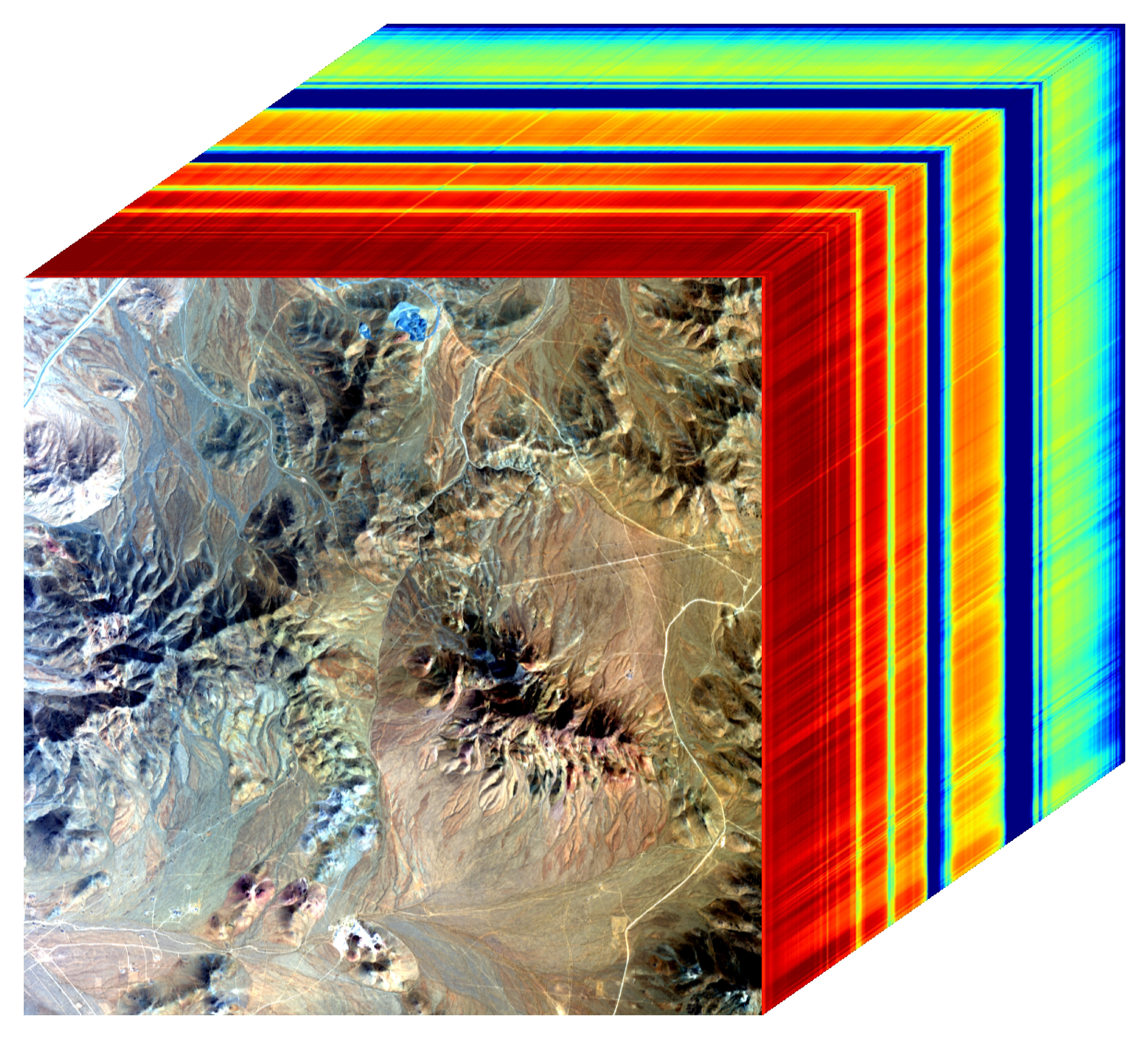
The sensor that detected the topaz deposit on public land near Barstow, California, was built at JPL. Called AVIRIS, short for Airborne Visible Infrared Imaging Spectrometer, it analyzes reflected sunlight and can be used to identify chemicals and minerals by their unique spectral fingerprint. The technology was pioneered in the early 1980s by a team that included Green, and space-hardened versions have explored the Moon, Mars, and other rocky bodies in the solar system in the decades since.
While its cousins study distant worlds aboard spacecraft, the AVIRIS line of sensors is advancing Earth science from aircraft. The latest model, AVIRIS-5, recently took to the skies for the first time as part of the NASA-USGS Geologic Earth Mapping Experiment (GEMx). The goal of GEMx is to identify sources of critical minerals across the American West, including in the waste rock of active and legacy mines. It is led by the USGS as part of its larger, nationwide initiative.
Carrying next-generation sensors, a high-altitude NASA ER-2 aircraft takes off from the agency’s Armstrong Flight Research Center in Edwards, California, on March 31, 2026, to support the GEMx mineral mapping campaign.NASA/Carla Thomas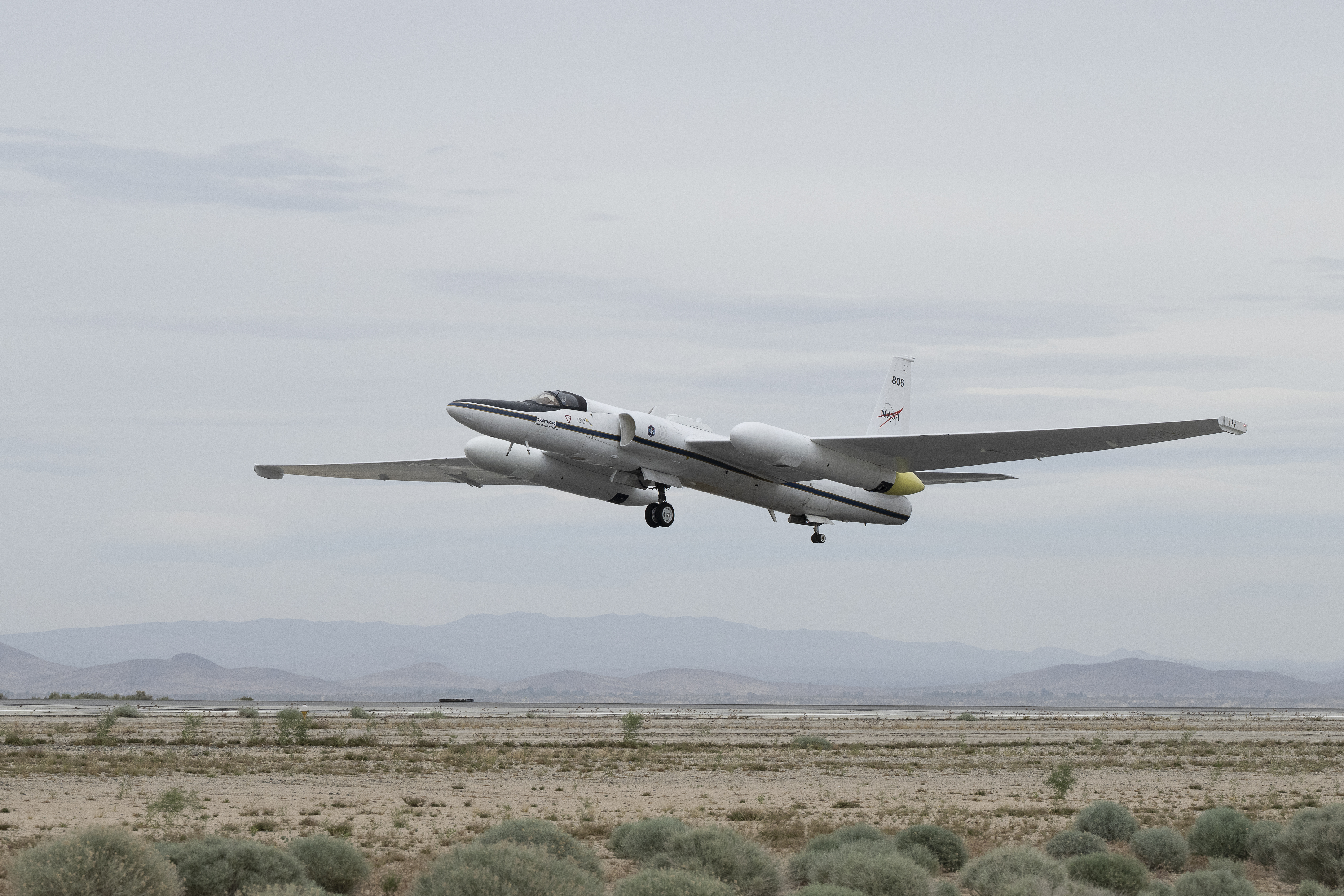
Since 2023, GEMx flights have covered more than 386,000 square miles (1 million square kilometers) of American soil, including most of California.
Ground-truthing the sensor data can entail hot field work, scrambling over steep crags to uncover samples for lab analysis. While testing has confirmed the topaz discovery, determining if the Mojave site overlies a porphyry copper deposit will require intensive investigation using ground-penetrating equipment. But the AVIRIS finding shows how advanced NASA airborne sensing can help lead geologists to the metaphorical needle in a haystack, even in heavily explored Southern California.
“People have been prospecting this area for generations,” said Erik Tharalson, a USGS geologist. “But there’s a lot more to discover.”
High flyerFrom the beginning, the GEMx mineral mapping campaign has been enabled by one of the highest-flying aircraft in NASA’s fleet: the ER‑2. It deployed on March 31 from NASA’s Armstrong Flight Research Center in Edwards, California, to Colorado Springs Airport in Colorado.
“We deployed to Colorado Springs to maximize flight time for data collection needed in Colorado, Utah, New Mexico, Arizona, and Texas,” said John McGrath, ER‑2 project manager at NASA Armstrong.
By the conclusion of this deployment on June 5, the aircraft had completed 26 flights totaling more than 125 hours. Soaring at about 65,000 feet, the ER-2 can fly at high altitudes that allow it to collect broad‑area, high‑resolution spectral measurements in a single pass, supporting researchers studying mineral composition and surface processes.
In 2025, the aircraft flew 36 science missions, collecting more than 7 billion measurements over 200 flight hours. The data has contributed to the largest airborne surface mineralogy dataset gathered in a single NASA-USGS campaign.
The GEMx survey is led and funded by the USGS Earth Mapping Resources Initiative. Earth MRI is modernizing mapping the nation’s surface and subsurface to find new, critical, and other minerals. It is a partnership effort with 45 state geological surveys, federal agencies, private industry, tribes, universities, and others. The initiative will capitalize on both the technology developed by NASA for spectroscopic imaging, as well as the USGS expertise in analyzing the datasets, conducting field work, and deriving critical mineral information from them.
To learn more about GEMx visit:
https://science.nasa.gov/mission/gemx/
Media Contacts
Andrew Wang / Andrew Good
Jet Propulsion Laboratory, Pasadena, Calif.
626-379-6874 / 818-393-2433
andrew.wang@jpl.nasa.gov / andrew.c.good@jpl.nasa.gov
Written by Sally Younger
2026-037
Explore More 6 min read Air Pollution’s Daily Pulse Over the NortheastThe TEMPO mission helped scientists track morning nitrogen dioxide that contributed to afternoon ozone along…
Article 23 hours ago 2 min read NASA, NOAA to Hold Joint Session at 23rd Symposium on Operational Environmental Satellite SystemsAbstracts are now being accepted for the session, which will take place at the 2027…
Article 1 day ago 9 min read Jim Irons, Former Landsat Project Scientist, Wins Pecora AwardLandsat’s Jim Irons won the prestigious William T. Pecora Award. Irons, now an emeritus scientist at…
Article 2 days ago Keep Exploring Discover More Topics From NASAGEMx
Armstrong Flight Research Center
Jet Propulsion Laboratory
Earth Science – Technology
NASA, USGS Scientists Go Rock Hounding in California’s High Desert
Equipped with rock picks and hand lenses, a team of geoscientists deployed to the Mojave Desert recently to investigate a tantalizing “fingerprint” detected by a NASA sensor. Their target: a cache of topaz hiding in plain sight.
The geologists weren’t searching for gem-grade treasure. Rather, the presence of topaz could hint at a more valuable deposit below of something known as porphyry copper.
One of the world’s primary sources of copper, these deposits are left behind when magma and hot water from deep underground course through Earth’s crust, chemically transforming the surrounding rock. This tends to occur where one tectonic plate dives below another, known as a subduction zone, such as the North American Cordillera, which stretches from the Canadian Rockies to western Mexico.
California’s high desert stretches below a bright spring sky in April 2026. NASA and USGS scientists are using airborne remote sensing to home in on potential sources of critical minerals here and across the Western U.S.NASA/JPL-CaltechIn addition to copper — the third most used metal in the world after steel and aluminum — the deposits can hold other critical minerals like molybdenum and tellurium, which are used in everything from steelmaking to solar panels. Finding the deposits isn’t easy. Geologists look for topaz because it forms under the same volcanic conditions.
For the team in the Mojave, the goal was to collect more evidence. That would require boots on the ground and a heavy bag of samples. The scientists who converged on the site included three experts from the U.S. Geological Survey (USGS) and Robert Green of NASA’s Jet Propulsion Laboratory in Southern California.
“What we’re doing out here is geologic CSI,” said Green, referring to the investigative TV show, as he split open a weathered red rock to expose a sparkling core. “We’re looking for clues to reconstruct what happened here.”
Three-dimensional image cubes illustrate the volume of data captured by NASA imaging spectrometers. The front face shows an aerial view of the Mojave Desert. The colorful side panels reveal what no eye or camera can detect: the spectral fingerprints of minerals present in every pixel.NASA/JPL-Caltech Next-generation mineral mappingThe sensor that detected the topaz deposit on public land near Barstow, California, was built at JPL. Called AVIRIS, short for Airborne Visible Infrared Imaging Spectrometer, it analyzes reflected sunlight and can be used to identify chemicals and minerals by their unique spectral fingerprint. The technology was pioneered in the early 1980s by a team that included Green, and space-hardened versions have explored the Moon, Mars, and other rocky bodies in the solar system in the decades since.
While its cousins study distant worlds aboard spacecraft, the AVIRIS line of sensors is advancing Earth science from aircraft. The latest model, AVIRIS-5, recently took to the skies for the first time as part of the NASA-USGS Geologic Earth Mapping Experiment (GEMx). The goal of GEMx is to identify sources of critical minerals across the American West, including in the waste rock of active and legacy mines. It is led by the USGS as part of its larger, nationwide initiative.
Carrying next-generation sensors, a high-altitude NASA ER-2 aircraft takes off from the agency’s Armstrong Flight Research Center in Edwards, California, on March 31, 2026, to support the GEMx mineral mapping campaign.NASA/Carla ThomasSince 2023, GEMx flights have covered more than 386,000 square miles (1 million square kilometers) of American soil, including most of California.
Ground-truthing the sensor data can entail hot field work, scrambling over steep crags to uncover samples for lab analysis. While testing has confirmed the topaz discovery, determining if the Mojave site overlies a porphyry copper deposit will require intensive investigation using ground-penetrating equipment. But the AVIRIS finding shows how advanced NASA airborne sensing can help lead geologists to the metaphorical needle in a haystack, even in heavily explored Southern California.
“People have been prospecting this area for generations,” said Erik Tharalson, a USGS geologist. “But there’s a lot more to discover.”
High flyerFrom the beginning, the GEMx mineral mapping campaign has been enabled by one of the highest-flying aircraft in NASA’s fleet: the ER‑2. It deployed on March 31 from NASA’s Armstrong Flight Research Center in Edwards, California, to Colorado Springs Airport in Colorado.
“We deployed to Colorado Springs to maximize flight time for data collection needed in Colorado, Utah, New Mexico, Arizona, and Texas,” said John McGrath, ER‑2 project manager at NASA Armstrong.
By the conclusion of this deployment on June 5, the aircraft had completed 26 flights totaling more than 125 hours. Soaring at about 65,000 feet, the ER-2 can fly at high altitudes that allow it to collect broad‑area, high‑resolution spectral measurements in a single pass, supporting researchers studying mineral composition and surface processes.
In 2025, the aircraft flew 36 science missions, collecting more than 7 billion measurements over 200 flight hours. The data has contributed to the largest airborne surface mineralogy dataset gathered in a single NASA-USGS campaign.
The GEMx survey is led and funded by the USGS Earth Mapping Resources Initiative. Earth MRI is modernizing mapping the nation’s surface and subsurface to find new, critical, and other minerals. It is a partnership effort with 45 state geological surveys, federal agencies, private industry, tribes, universities, and others. The initiative will capitalize on both the technology developed by NASA for spectroscopic imaging, as well as the USGS expertise in analyzing the datasets, conducting field work, and deriving critical mineral information from them.
To learn more about GEMx visit:
https://science.nasa.gov/mission/gemx/
Media Contacts
Andrew Wang / Andrew Good
Jet Propulsion Laboratory, Pasadena, Calif.
626-379-6874 / 818-393-2433
andrew.wang@jpl.nasa.gov / andrew.c.good@jpl.nasa.gov
Written by Sally Younger
2026-037
Explore More 5 min read World Cup Fever in GuadalajaraThe city’s metro area has pushed westward since it last hosted World Cup matches in…
Article 2 hours ago 6 min read Air Pollution’s Daily Pulse Over the NortheastThe TEMPO mission helped scientists track morning nitrogen dioxide that contributed to afternoon ozone along…
Article 1 day ago 2 min read NASA, NOAA to Hold Joint Session at 23rd Symposium on Operational Environmental Satellite SystemsAbstracts are now being accepted for the session, which will take place at the 2027…
Article 2 days ago Keep Exploring Discover More Topics From NASAGEMx
Armstrong Flight Research Center
Jet Propulsion Laboratory
Earth Science – Technology
Humans and AI race to ‘blow up’ math’s toughest equations
New results challenge AI’s promise for solving how fluids swirl—and suggest a more human path forward
ESA at ILA 2026 – Day 2 highlights
From strategic discussions on autonomy and resilience to an in-flight call with ESA astronaut Sophie Adenot, ESA's second day at ILA Berlin International Airshow 2026 highlighted the wide-reaching value of space for Europe now and in the future.