
Feed aggregator
Harmonized Landsat and Sentinel-2: Collaboration Drives Innovation
9 min read
Harmonized Landsat and Sentinel-2: Collaboration Drives InnovationIntroduction
Landsat, a joint program of NASA and the U.S. Geological Survey (USGS), has been an invaluable tool for monitoring changes in Earth’s land surface for over 50 years. Researchers use instruments on Landsat satellites to monitor decades-long trends, including urbanization and agricultural expansion, as well as short-term dynamics, including water use and disaster recovery. However, scientists and land managers often encounter one critical limitation of this program: Landsat has a revisit time of eight days (with Landsat 8 and 9 operating), which is too long to capture events and disasters that occur on short timescales. Floods, for example, can quickly inundate a region, and cloud cover from storms can delay Landsat’s ability to get a clear observation on damage.
In 2015, the European Space Agency’s (ESA) Copernicus Sentinel-2A mission joined Landsat 7 and 8 in orbit. It was designed to collect comparable optical land data with the intention of leveraging Landsat’s archive. Two years later, ESA launched Sentinel-2B, a satellite identical to Sentinel-2A.
Led by a science team at NASA’s Goddard Space Flight Center (GSFC), the USGS, NASA, and ESA began to work on combining the capabilities of Sentinel-2 and Landsat satellites. This idea was the impetus behind Harmonized Landsat and Sentinel-2 (HLS) project, a NASA initiative that created a seamless product from the Operational Land Imager (OLI) and Multi-Spectral Instrument (MSI) aboard Landsat and Sentinel-2 satellites, respectively. HLS Version 2.0 (V2.0) is the most recent version of these data and had a global median repeat frequency of 1.6 days in 2022 by combining observations from Landsat 8 and 9 and Sentinel-2A and B. The recent addition of Sentinel-2C data will provide even more frequent observations. With near-global coverage and improved harmonization algorithms, HLS V2.0 paves the way for new applications and improved land monitoring systems – see Animation 1. HLS data are available for download on NASA Earthdata: HLSL30v2.0 and HLSS30v2.0. These data can also be accessed through Google Earth Engine: HLSL30v2.0 and HLSS30v2.0.
Animation 1. This visualization shows the change in vegetation in Maryland from January 1 to December 30, 2016, using Normalized Difference Vegetation Index (NDVI) data from Harmonized Landsat Sentinel-2 (HLS). The visualization shows land on both sides of the Chesapeake Bay, where red represents bare soil and green indicates healthy, growing vegetation.Animation credit: Michael Taylor [Science Systems and Applications Inc. (SSAI)], Matthew Radcliff [USRA], and Jeffrey Masek [GSFC]. Caption adapted from Laura Rocchio [SSAI]The Dawn of HLS
The story of HLS begins before the launch of Sentinel-2A in 2015. Jeffrey Masek [GSFC], who was at that time project scientist for Landsat 8, led a group of researchers who wanted to find a way to harmonize Landsat data with other satellite data. Their aim was to create a “virtual constellation” similar to how weather satellites operate.
“HLS meets a need that people have been asking for for a long time,” said Masek.
What began as a research question with an experimental product evolved into an operational project with the involvement of the Satellite Needs Working Group (SNWG). SNWG is an interagency effort to develop solutions that address Earth observation needs of civilian federal agencies. Every two years, SNWG conducts a survey of federal agencies to see how their work could benefit from satellite data. The answers span the gamut of application areas, from water quality monitoring to disaster recovery to planning how best to protect and use natural resources. SNWG brings these ideas to NASA, USGS, and the National Oceanic and Atmospheric Administration (NOAA) – the three main U.S. government providers of satellite data. These agencies work together to create and implement solutions that serve those needs. NASA plays a critical role in every step of the SNWG process, including leading the assessment of survey responses from over 30 federal agencies, managing and supporting the implementation of identified solutions, and encouraging solution co-design with federal partners to maximize impact.
The HLS surface reflectance product was an outcome of the very first SNWG solution cycle in 2016. This product was expanded, following additional SNWG requests in 2020 and 2022. The 2020 cycle saw the creation of nine HLS-derived vegetation indices, and the 2022 cycle aimed for a six-hour latency product.
The U.S. Department of Agriculture (USDA) now uses HLS to map crop emergence at the field scale in the corn belt, allowing farmers to better plan their growing seasons. Ranchers in Colorado use the dataset to decide where to graze their cattle during periods of drought. HLS also informs the use and termination of cover crops in the Chesapeake Bay area. In 2024, the Federal Emergency Management Agency (FEMA) employed HLS to identify where to focus aid in the aftermath of Hurricane Helene.
A New and Improved HLS
In the July 2025 issue of Remote Sensing of Environment, a team of researchers outlined the HLS V2.0 surface reflectance dataset and algorithms. The team included seven NASA co-authors, members of the 2018–2023 Landsat Science Team, and ESA. The lead author, Junchang Ju [GSFC—Remote Sensing Scientist], has been the technical lead on HLS since its inception. Co-author Christopher Neigh [GSFC—Landsat 8/9 Project Scientist] is the principal investigator on the HLS project. V2.0, which was completed in Summer 2023, incorporates several major improvements over HLS V1.4, the most recent publicly available HLS product. The HLS production team at NASA’s Marshall Space Flight Center (MSFC), led by Madhu Sridhar [University of Alabama in Huntsville—Research Scientist], ensures consistent data access through close collaboration with ESA and the Land Processes Distributed Active Archive Center (LP DAAC). HLS V1.4 covered about 30% of the global land area, providing data on North America and other select locations. HLS V2.0 provides data at a spatial resolution of 30 m (98 ft) with near-global coverage from 2013 onward. The dataset includes all land masses except Antarctica. HLS V2.0 also has key algorithmic improvements in atmospheric correction, cloud masking, and bidirectional reflectance distribution function (BRDF) correction. Together, these algorithms “harmonize” the data, or ensure that the distinct Landsat and Sentinel-2 datasets can effectively be used interchangeably – see Animation 2.
Animation 2: The visualization provides the Normalized Difference Vegetation Index (NDVI) data from Harmonized Landsat Sentinel-2 (HLS) for farm fields south of Columbus, NE. The red represents bare soil and green represents healthy, growing vegetation. The animation runs from January 1 to December 30, 2016.Animation credit: Michael Taylor [SSAI], Matthew Radcliff [USRA], and Jeffrey Masek [GSFC]. Caption adapted from Laura Rocchio [SSAI]HLS V2.0 in Action
The increased frequency of observations improved the ability of the scientific community to track disaster recovery, changes in phenology, agricultural intensification, rapid urban growth, logging, and deforestation. Researchers are already putting these advances to use.
The land disturbance product (DIST-ALERT) is a global land change monitoring system that uses HLS V2.0 data to track vegetation anomalies in near real-time – see Figure 1. DIST-ALERT captures agricultural expansion, urban growth, fire, flooding, logging, drought, landslides, and other forces of change to vegetation. Amy Pickens [University of Maryland, Department of Geographical Sciences—Assistant Research Professor] said that HLS is the perfect dataset for tracking disturbances because of the frequency of observations.
DIST-ALERT was created through Observational Products for End-Users from Remote Sensing Analysis (OPERA), a project at NASA/Jet Propulsion Laboratory (JPL). OPERA products respond to agency needs identified by the SNWG. In 2018, SNWG identified tracking surface disturbance as a key need. OPERA partnered with the Global Land Analysis and Discovery (GLAD) lab at University of Maryland to develop the change detection algorithm.
To track changes in vegetation, the DIST-ALERT system establishes a rolling baseline – meaning that for any given pixel, the vegetation cover is compared against vegetation cover from the same 31-day window in the previous three years. The primary algorithm detects any vegetation loss relative to the established baseline. A secondary algorithm flags any spectral anomaly (i.e., any change in reflectance) compared to that same baseline. This approach ensures that the algorithm catches non-vegetation change (e.g., new building or road projects in unvegetated areas). Used together, these algorithms can identify long-term changes in agricultural expansion, deforestation, and urbanization alongside short-term changes in crop harvest, drought, selective logging, and the impacts of disasters. On average, DIST-ALERT is made available on LP DAAC within six hours of when new HLS data is available. Currently, the dataset does not provide attribution to disturbances.
Figure 1. In March 2025, wildfires burned through South Korea, resulting in heavy vegetation loss. [left] Output of the DIST-ALERT product on NASA Worldview from May 8, 2025, with vegetation loss in percent flagged with varying levels of confidence. Yellow and red represent areas with confirmed vegetation cover losses of <50% and ≥50%, respectively. [right] Natural-color image captured by the Multi-Spectral Instrument (MSI) aboard Sentinel-2C on May 8, 2025. The large brown burn scar in the center of the image corresponds to vegetation loss detected by DIST-ALERT. It stands in contrast to the surrounding green vegetation.Figure credit: NASA Earthdata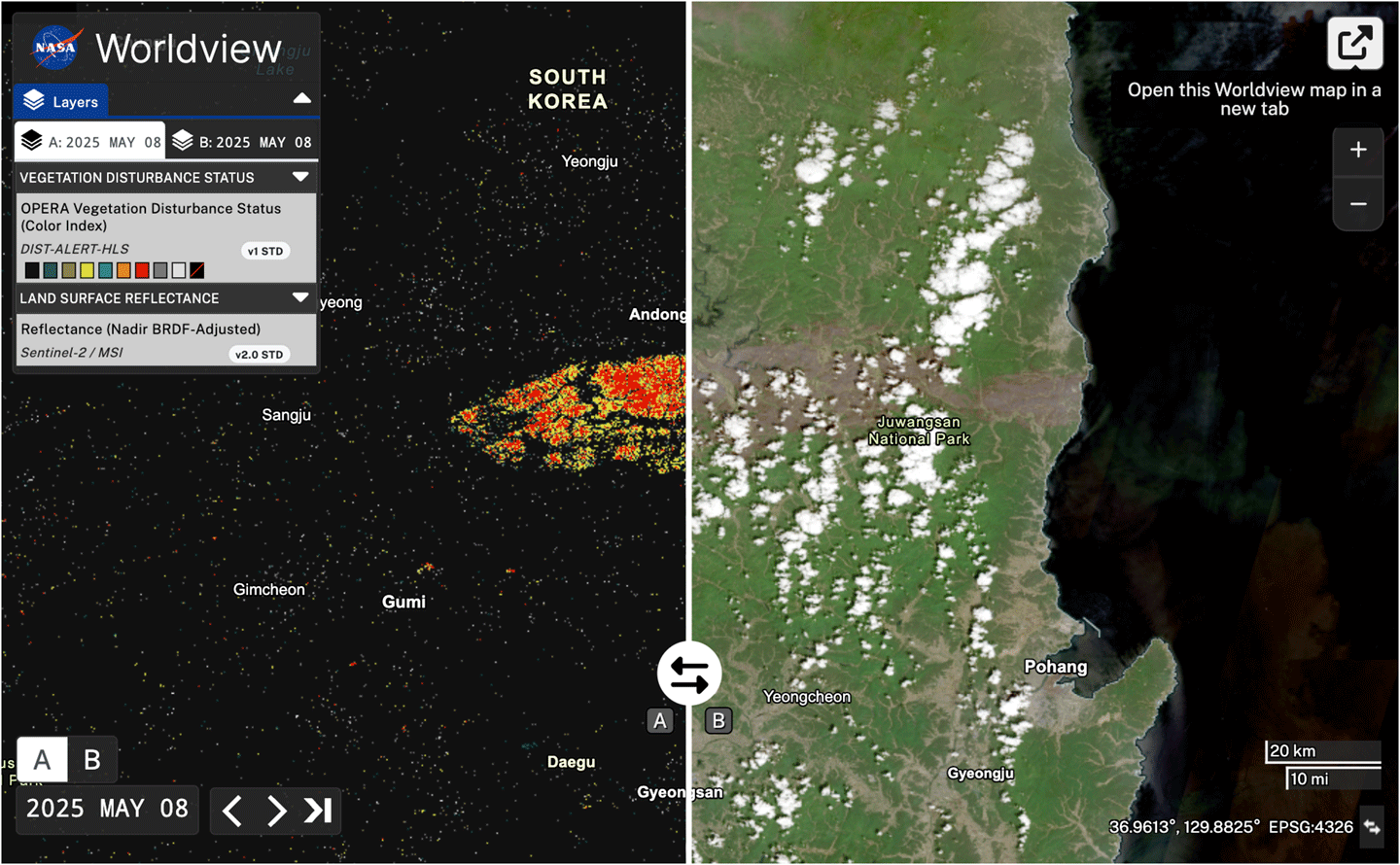
Disturbance alerts already exist in some ecosystems. Brazil’s National Institute for Space Research [Instituto Nacional de Pesquisas Espaciais (INPE)] runs two projects that detect deforestation in the Amazon: Programa de Cálculo do Desflorestamento da Amazônia (PRODES) and Sistema de Detecção de Desmatamento em Tempo Real (DETER). The GLAD lab created its own forest loss alerts – GLAD-L and GLAD-S2 – using Landsat and Sentinel-2 data respectively. Global Forest Watch integrates GLAD-L and GLAD-S2 data with Radar for Detecting Deforestation (RADD) observations – derived from synthetic aperture radar data from Copernicus Sentinel-1 – into an integrated deforestation alert.
The implementation of these alert systems, some of which have been around for decades, have been shown to impact deforestation rates in the tropics. For example, a 2021 study in Nature Climate Change found that deforestation alerts decreased the probability of deforestation in Central Africa by 18% relative to the average 2011–2016 levels.
DIST-ALERT is distinct from other alert systems in a few ways. First, it has global coverage. Second, the rolling baseline allows for tracking changes in seasonality and disturbances to dynamic ecosystems. When HLS V2.0 data are input to DIST-ALERT, the system is also better at identifying disturbances in cloudy ecosystems than other individual alert systems – because it is more likely to obtain clear observations. This also enables it to identify the start and end of the disturbance more precisely.
Pickens said that the DIST-ALERT team is already working with end-users who are implementing their data product. She has spoken to some who use the system to help logging companies prove that they are complying with regulations. The U.S. Census Bureau is also using DIST-ALERT to monitor fast-growing communities so that they can do targeted assessments in the interim between the larger decennial census.
Alongside DIST-ALERT, OPERA has also been developing the Dynamic Surface Water eXtent (DSWx) product suite, which employs HLS to track surface water (e.g., lakes, reservoirs, rivers, and floods) around the globe – see Figure 2. These new products represent the new applications made possible by the HLS interagency and international collaboration.
Figure 2. The map shows flood extent and estimates of flood depth in areas west of Porto Alegre, Brazil on May 6, 2024. The flood extent is from the Observational Products for End-Users from Remote Sensing Analysis (OPERA) Dynamic Surface Water eXtent product, which uses Harmonized Landsat Sentinel-2 data. The flood depth estimate is from the Floodwater Depth Estimation Tool (FwD ET). The darkest blue areas represent floodwater at least 5 m (20 ft) deep. Much of the inundated floodplain is light blue, which equates to depths of between 0.1–1 m (4–40 in).Figure credit: Lauren Dauphin [NASA’s Earth Observatory], Dinuke Munasinghe [JPL], Sagy Cohen [University of Alabama], and Alexander Handwerger [JPL]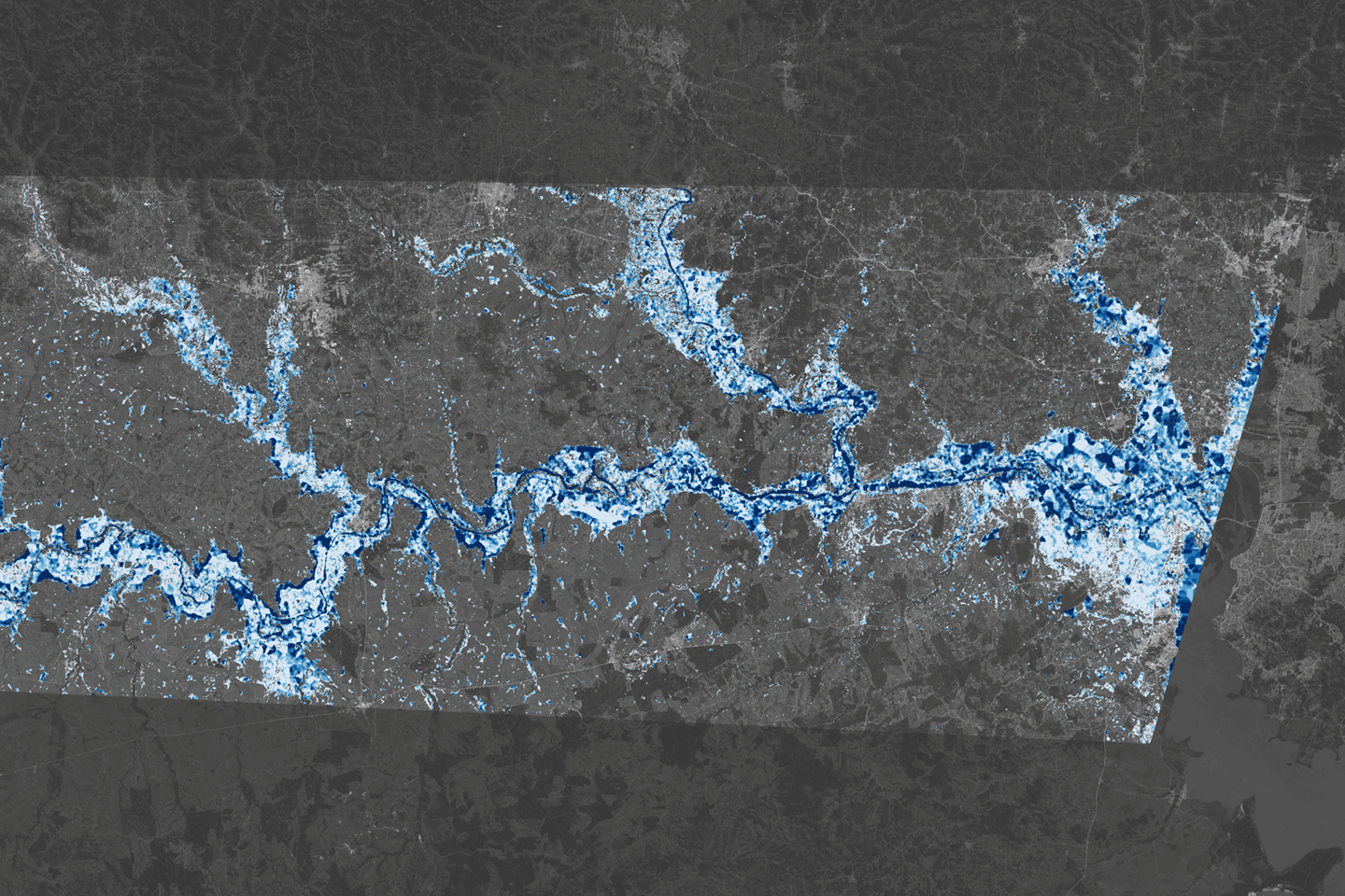
Conclusion
HLS is set to continue improving land monitoring efforts across the globe. Meanwhile, the HLS science team is working to improve the algorithms for a more seamless harmonization of Landsat 8 and 9 and Sentinel-2 data. They are also working to improve the cloud-masking algorithm, have recently released vegetation indices, and are working on developing a low-latency (six-hour) HLS surface reflectance product, all while incorporating user feedback.
Looking ahead, the launch of future Sentinel and Landsat satellites will further the development of HLS. The additional data and unique capabilities will continue to meet researchers’ need for more frequent, high-quality satellite observations of Earth’s land surface.
Madeleine Gregory
NASA’s Goddard Space Flight Center/Science Systems and Applications Inc.
madeleine.s.gregory@nasa.gov
Harmonized Landsat and Sentinel-2: Collaboration Drives Innovation
9 min read
Harmonized Landsat and Sentinel-2: Collaboration Drives InnovationIntroduction
Landsat, a joint program of NASA and the U.S. Geological Survey (USGS), has been an invaluable tool for monitoring changes in Earth’s land surface for over 50 years. Researchers use instruments on Landsat satellites to monitor decades-long trends, including urbanization and agricultural expansion, as well as short-term dynamics, including water use and disaster recovery. However, scientists and land managers often encounter one critical limitation of this program: Landsat has a revisit time of eight days (with Landsat 8 and 9 operating), which is too long to capture events and disasters that occur on short timescales. Floods, for example, can quickly inundate a region, and cloud cover from storms can delay Landsat’s ability to get a clear observation on damage.
In 2015, the European Space Agency’s (ESA) Copernicus Sentinel-2A mission joined Landsat 7 and 8 in orbit. It was designed to collect comparable optical land data with the intention of leveraging Landsat’s archive. Two years later, ESA launched Sentinel-2B, a satellite identical to Sentinel-2A.
Led by a science team at NASA’s Goddard Space Flight Center (GSFC), the USGS, NASA, and ESA began to work on combining the capabilities of Sentinel-2 and Landsat satellites. This idea was the impetus behind Harmonized Landsat and Sentinel-2 (HLS) project, a NASA initiative that created a seamless product from the Operational Land Imager (OLI) and Multi-Spectral Instrument (MSI) aboard Landsat and Sentinel-2 satellites, respectively. HLS Version 2.0 (V2.0) is the most recent version of these data and had a global median repeat frequency of 1.6 days in 2022 by combining observations from Landsat 8 and 9 and Sentinel-2A and B. The recent addition of Sentinel-2C data will provide even more frequent observations. With near-global coverage and improved harmonization algorithms, HLS V2.0 paves the way for new applications and improved land monitoring systems – see Animation 1. HLS data are available for download on NASA Earthdata: HLSL30v2.0 and HLSS30v2.0. These data can also be accessed through Google Earth Engine: HLSL30v2.0 and HLSS30v2.0.
Animation 1. This visualization shows the change in vegetation in Maryland from January 1 to December 30, 2016, using Normalized Difference Vegetation Index (NDVI) data from Harmonized Landsat Sentinel-2 (HLS). The visualization shows land on both sides of the Chesapeake Bay, where red represents bare soil and green indicates healthy, growing vegetation. Animation credit: Michael Taylor [Science Systems and Applications Inc. (SSAI)], Matthew Radcliff [USRA], and Jeffrey Masek [GSFC]. Caption adapted from Laura Rocchio [SSAI]The Dawn of HLS
The story of HLS begins before the launch of Sentinel-2A in 2015. Jeffrey Masek [GSFC], who was at that time project scientist for Landsat 8, led a group of researchers who wanted to find a way to harmonize Landsat data with other satellite data. Their aim was to create a “virtual constellation” similar to how weather satellites operate.
“HLS meets a need that people have been asking for for a long time,” said Masek.
What began as a research question with an experimental product evolved into an operational project with the involvement of the Satellite Needs Working Group (SNWG). SNWG is an interagency effort to develop solutions that address Earth observation needs of civilian federal agencies. Every two years, SNWG conducts a survey of federal agencies to see how their work could benefit from satellite data. The answers span the gamut of application areas, from water quality monitoring to disaster recovery to planning how best to protect and use natural resources. SNWG brings these ideas to NASA, USGS, and the National Oceanic and Atmospheric Administration (NOAA) – the three main U.S. government providers of satellite data. These agencies work together to create and implement solutions that serve those needs. NASA plays a critical role in every step of the SNWG process, including leading the assessment of survey responses from over 30 federal agencies, managing and supporting the implementation of identified solutions, and encouraging solution co-design with federal partners to maximize impact.
The HLS surface reflectance product was an outcome of the very first SNWG solution cycle in 2016. This product was expanded, following additional SNWG requests in 2020 and 2022. The 2020 cycle saw the creation of nine HLS-derived vegetation indices, and the 2022 cycle aimed for a six-hour latency product.
The U.S. Department of Agriculture (USDA) now uses HLS to map crop emergence at the field scale in the corn belt, allowing farmers to better plan their growing seasons. Ranchers in Colorado use the dataset to decide where to graze their cattle during periods of drought. HLS also informs the use and termination of cover crops in the Chesapeake Bay area. In 2024, the Federal Emergency Management Agency (FEMA) employed HLS to identify where to focus aid in the aftermath of Hurricane Helene.
A New and Improved HLS
In the July 2025 issue of Remote Sensing of Environment, a team of researchers outlined the HLS V2.0 surface reflectance dataset and algorithms. The team included seven NASA co-authors, members of the 2018–2023 Landsat Science Team, and ESA. The lead author, Junchang Ju [GSFC—Remote Sensing Scientist], has been the technical lead on HLS since its inception. Co-author Christopher Neigh [GSFC—Landsat 8/9 Project Scientist] is the principal investigator on the HLS project. V2.0, which was completed in Summer 2023, incorporates several major improvements over HLS V1.4, the most recent publicly available HLS product. HLS V1.4 covered about 30% of the global land area, providing data on North America and other select locations. HLS V2.0 provides data at a spatial resolution of 30 m (98 ft) with near-global coverage from 2013 onward. The dataset includes all land masses except Antarctica. HLS V2.0 also has key algorithmic improvements in atmospheric correction, cloud masking, and bidirectional reflectance distribution function (BRDF) correction. Together, these algorithms “harmonize” the data, or ensure that the distinct Landsat and Sentinel-2 datasets can effectively be used interchangeably – see Animation 2.
Animation 2: The visualization provides the Normalized Difference Vegetation Index (NDVI) data from Harmonized Landsat Sentinel-2 (HLS) for farm fields south of Columbus, NE. The red represents bare soil and green represents healthy, growing vegetation. The animation runs from January 1 to December 30, 2016. Animation credit: Michael Taylor [SSAI], Matthew Radcliff [USRA], and Jeffrey Masek [GSFC]. Caption adapted from Laura Rocchio [SSAI]HLS V2.0 in Action
The increased frequency of observations improved the ability of the scientific community to track disaster recovery, changes in phenology, agricultural intensification, rapid urban growth, logging, and deforestation. Researchers are already putting these advances to use.
The land disturbance product (DIST-ALERT) is a global land change monitoring system that uses HLS V2.0 data to track vegetation anomalies in near real-time – see Figure 1. DIST-ALERT captures agricultural expansion, urban growth, fire, flooding, logging, drought, landslides, and other forces of change to vegetation. Amy Pickens [University of Maryland, Department of Geographical Sciences—Assistant Research Professor] said that HLS is the perfect dataset for tracking disturbances because of the frequency of observations.
DIST-ALERT was created through Observational Products for End-Users from Remote Sensing Analysis (OPERA), a project at NASA/Jet Propulsion Laboratory (JPL). OPERA products respond to agency needs identified by the SNWG. In 2018, SNWG identified tracking surface disturbance as a key need. OPERA partnered with the Global Land Analysis and Discovery (GLAD) lab at University of Maryland to develop the change detection algorithm.
To track changes in vegetation, the DIST-ALERT system establishes a rolling baseline – meaning that for any given pixel, the vegetation cover is compared against vegetation cover from the same 31-day window in the previous three years. The primary algorithm detects any vegetation loss relative to the established baseline. A secondary algorithm flags any spectral anomaly (i.e., any change in reflectance) compared to that same baseline. This approach ensures that the algorithm catches non-vegetation change (e.g., new building or road projects in unvegetated areas). Used together, these algorithms can identify long-term changes in agricultural expansion, deforestation, and urbanization alongside short-term changes in crop harvest, drought, selective logging, and the impacts of disasters. On average, DIST-ALERT is made available on LP DAAC within six hours of when new HLS data is available. Currently, the dataset does not provide attribution to disturbances.
Figure 1. In March 2025, wildfires burned through South Korea, resulting in heavy vegetation loss. [left] Output of the DIST-ALERT product on NASA Worldview from May 8, 2025, with vegetation loss in percent flagged with varying levels of confidence. Yellow and red represent areas with confirmed vegetation cover losses of <50% and ≥50%, respectively. [right] Natural-color image captured by the Multi-Spectral Instrument (MSI) aboard Sentinel-2C on May 8, 2025. The large brown burn scar in the center of the image corresponds to vegetation loss detected by DIST-ALERT. It stands in contrast to the surrounding green vegetation. Figure credit: NASA EarthdataDisturbance alerts already exist in some ecosystems. Brazil’s National Institute for Space Research [Instituto Nacional de Pesquisas Espaciais (INPE)] runs two projects that detect deforestation in the Amazon: Programa de Cálculo do Desflorestamento da Amazônia (PRODES) and Sistema de Detecção de Desmatamento em Tempo Real (DETER). The GLAD lab created its own forest loss alerts – GLAD-L and GLAD-S2 – using Landsat and Sentinel-2 data respectively. Global Forest Watch integrates GLAD-L and GLAD-S2 data with Radar for Detecting Deforestation (RADD) observations – derived from synthetic aperture radar data from Copernicus Sentinel-1 – into an integrated deforestation alert.
The implementation of these alert systems, some of which have been around for decades, have been shown to impact deforestation rates in the tropics. For example, a 2021 study in Nature Climate Change found that deforestation alerts decreased the probability of deforestation in Central Africa by 18% relative to the average 2011–2016 levels.
DIST-ALERT is distinct from other alert systems in a few ways. First, it has global coverage. Second, the rolling baseline allows for tracking changes in seasonality and disturbances to dynamic ecosystems. When HLS V2.0 data are input to DIST-ALERT, the system is also better at identifying disturbances in cloudy ecosystems than other individual alert systems – because it is more likely to obtain clear observations. This also enables it to identify the start and end of the disturbance more precisely.
Pickens said that the DIST-ALERT team is already working with end-users who are implementing their data product. She has spoken to some who use the system to help logging companies prove that they are complying with regulations. The U.S. Census Bureau is also using DIST-ALERT to monitor fast-growing communities so that they can do targeted assessments in the interim between the larger decennial census.
Alongside DIST-ALERT, OPERA has also been developing the Dynamic Surface Water eXtent (DSWx) product suite, which employs HLS to track surface water (e.g., lakes, reservoirs, rivers, and floods) around the globe – see Figure 2. These new products represent the new applications made possible by the HLS interagency and international collaboration.
Figure 2. The map shows flood extent and estimates of flood depth in areas west of Porto Alegre, Brazil on May 6, 2024. The flood extent is from the Observational Products for End-Users from Remote Sensing Analysis (OPERA) Dynamic Surface Water eXtent product, which uses Harmonized Landsat Sentinel-2 data. The flood depth estimate is from the Floodwater Depth Estimation Tool (FwD ET). The darkest blue areas represent floodwater at least 5 m (20 ft) deep. Much of the inundated floodplain is light blue, which equates to depths of between 0.1–1 m (4–40 in). Figure credit: Lauren Dauphin [NASA’s Earth Observatory], Dinuke Munasinghe [JPL], Sagy Cohen [University of Alabama], and Alexander Handwerger [JPL]Conclusion
HLS is set to continue improving land monitoring efforts across the globe. Meanwhile, the HLS science team is working to improve the algorithms for a more seamless harmonization of Landsat 8 and 9 and Sentinel-2 data. They are also working to improve the cloud-masking algorithm, have recently released vegetation indices, and are working on developing a low-latency (six-hour) HLS surface reflectance product, all while incorporating user feedback.
Looking ahead, the launch of future Sentinel and Landsat satellites will further the development of HLS. The additional data and unique capabilities will continue to meet researchers’ need for more frequent, high-quality satellite observations of Earth’s land surface.
Madeleine Gregory
NASA’s Goddard Space Flight Center/Science Systems and Applications Inc.
madeleine.s.gregory@nasa.gov
NASA Implementation of Executive Order 14303
Aug 22, 2025
PDF (277.15 KB)
NASA Implementation of Executive Order 14303
Aug 22, 2025
PDF (277.15 KB)
An incredible Denisovan skull is upending the story of human evolution
An incredible Denisovan skull is upending the story of human evolution
Dark matter could create black holes that devour exoplanets from within
Don't miss Mars close to the slender crescent moon at sunset tonight
Radio dish on the move | Space photo of the day for Aug. 25, 2025
ESA data records help underpin climate change report
According to the newly released 35th State of the Climate report, 2024 saw record highs in greenhouse gas concentrations, global land and ocean temperatures, sea levels, and ocean heat content. Glaciers also suffered their largest annual ice loss on record. Data records from ESA’s Climate Change Initiative helped underpin these findings.
A New Model for Early Black Hole Formation Could Revolutionize Cosmologicy
A new theoretical study by University of Virginia astrophysicist Jonathan Tan, a research professor with the College and Graduate School of Arts & Sciences’ Department of Astronomy, proposes a comprehensive framework for the birth of supermassive black holes.
NASA Commanded Psyche To Turn Around And Capture Images Of Earth And The Moon
New images from NASA's Psyche spacecraft show that its cameras are working just fine. By pointing them at Earth and the Moon, NASA was able to test the spacecraft's cameras and science instruments. Since both bodies reflect light like Psyche, and since their spectra are familiar, it's a valuable opportunity to test and calibrate the instruments.
Roman's High-Latitude Time-Domain Survey Will Find Tens of Thousands of Supernovae
For thousands of years, humanity viewed the skies as unchanging, except for a few “wandering stars” (that we now know are planets). As we improved our ability to perceive the cosmos with light-gathering telescopes and electronic detectors, we realized that the universe is full of things that change in brightness, whether it be an exploding star or a matter-gulping black hole. NASA’s Nancy Grace Roman Space Telescope is poised to deliver an avalanche of such transients, including thousands of “standard candle” supernovae that allow us to measure the expansion history of the universe.
These Rare Star Systems Are A New Tool To Understand Brown Dwarfs
The discovery of an extremely rare quadruple star system could significantly advance our understanding of brown dwarfs, astronomers say. Brown dwarfs in wide binary orbits offer a chance to determine their properties more clearly.
SpaceX to Launch Secret X-37B Space Plane Thursday
The hunt will be on shortly, to once again recover a clandestine mission in low Earth orbit. SpaceX is set to launch a Falcon-9 rocket from launch pad LC-39A at the Kennedy Space Center Thursday night August 21st, with the classified USSF-36 mission. The U.S. Space Force has announced that this is the eighth mission for its fleet of two Orbital Test Vehicles (OTV-8). This is the automated ‘mini-space shuttle’ about the size of a large SUV that launches like a rocket, and lands like a plane.
Using Video Game Techniques To Optimize Solar Sails
Sometimes inspiration can strike from the most unexpected places. It can result in a cross-pollination between ideas commonly used in one field but applied to a completely different one. That might have been the case with a recent paper on lightsail design from researchers at the University of Nottingham that used techniques typically used in video games to develop a new and improved structure of a lightsail.
60-Second Astro News: Light Pollution, Birds, and Zambuto Mirrors
In this roundup of recent news, birds react to light pollution and a respected mirror maker calls it a day.
The post 60-Second Astro News: Light Pollution, Birds, and Zambuto Mirrors appeared first on Sky & Telescope.
The Way People Search the Internet Can Fuel Echo Chambers
Users’ Internet search questions can strengthen echo chambers, even on factual topics, but there are simple ways to lessen the effect
180 Years of Scientific American Means 180-Degree Turns in Science—Here Are Some of the Wildest Ones
In honor of SciAm’s 180th birthday, we’re spotlighting the biggest “wait, what?” moments in science history.
Juice team resolves anomaly on approach to Venus
The European Space Agency’s Jupiter Icy Moons Explorer (Juice) is on track for its gravity-assist flyby at Venus on 31 August, following the successful resolution of a spacecraft communication anomaly that temporarily severed contact with Earth.
The issue, which emerged during a routine ground station pass on 16 July, temporarily disrupted Juice’s ability to transmit information about its health and status (telemetry).
Thanks to swift and coordinated action by the teams at ESA’s European Space Operations Centre (ESOC) in Darmstadt, Germany, and Juice’s manufacturer, Airbus, communication was restored in time to prepare for the upcoming planetary encounter.