
Feed aggregator
Reducing high blood pressure can cut risk of dementia
Reducing high blood pressure can cut risk of dementia
How Pope Francis Influenced Global Climate Change Action
The late Pope Francis supported global climate agreements, advocated for Indigenous people and inspired activism
A dramatic rethink of Parkinson’s offers new hope for treatment
A dramatic rethink of Parkinson’s offers new hope for treatment
Bacteria That Can Mimic Multi-Cellular Life
Scientists are still trying to understand the origin of multicellular life. It emerged about 1.2 billion years ago (or even earlier, according to some debated evidence). The timing of multicellular life's appearance on Earth is not the only thing being debated; so are the mechanisms behind it. New research supports the idea that multicellular life began when single-celled bacteria started grouping together.
Celebrating Earth as Only NASA Can
3 min read
Preparations for Next Moonwalk Simulations Underway (and Underwater) NASA’s Earth Day Poster for 2025 uses imagery from the Landsat mission — a joint mission with USGS — to celebrate our home planet. NASA/USGS/Landsat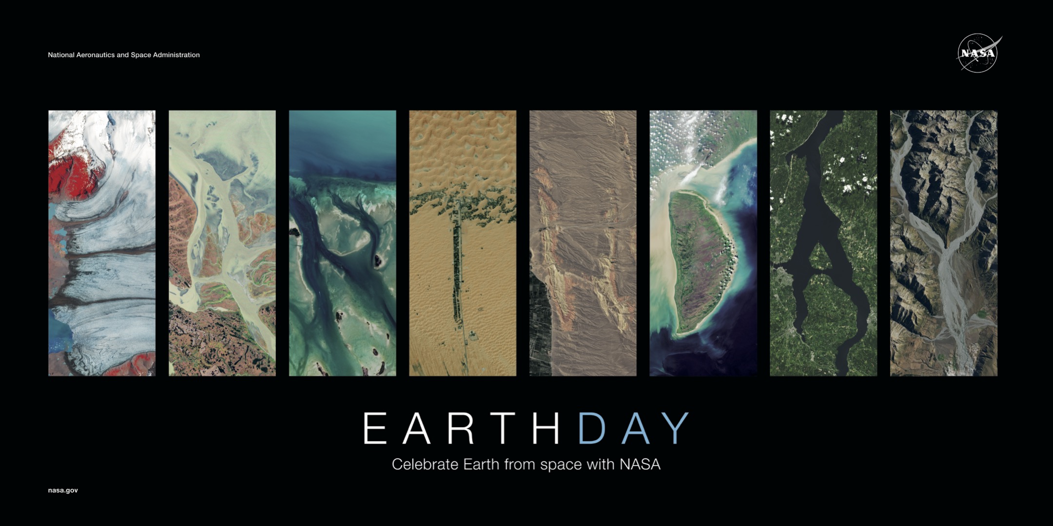
Lee esta historia en español aquí.
From the iconic image of Earthrise taken by Apollo 8 crew, to the famous Pale Blue Dot image of Earth snapped by Voyager I spacecraft, to state-of-the-art observations of our planet by new satellites such as PACE (Plankton, Aerosol, Cloud, ocean Ecosystem), NASA has given us novel ways to see our home. This Earth Day, NASA is sharing how — by building on decades of innovation—we use the unique vantage point of space to observe and understand our dynamic planet in ways that we cannot from the ground.
NASA has been observing Earth from space for more than 60 years, with cutting-edge scientific technology that can revolutionize our understanding of our home planet and provide benefits to all humanity. NASA observations include land data that helps farmers improve crop production, research on the air we breathe, and studies of atmospheric layers high above us that protect every living thing on the planet.
“NASA Science delivers every second of every day for the benefit all, and it begins with how we observe our home planet from the unique vantage point of space,” said Nicky Fox, associate administrator, Science Mission Directorate at NASA Headquarters in Washington. “Our satellites, Mars rovers, astronauts and other NASA Science missions send back beautiful images of our planet, from the smallest of plankton to the pale blue dot, to help give us a comprehensive, detailed view of our home that we especially celebrate each Earth Day.”
NASA data and tools are vital to federal, state, local, and international governments to monitor and manage land, air, and water resources. From mapping the ocean floor to finding critical mineral deposits to alerting land managers when fire risk is high, NASA’s data and information informs nearly every aspect of our economy and our lives.
“Another way NASA celebrates Earth Day is by sharing information about how our science benefits the entire nation, such as by providing U.S. farmers and ranchers with ongoing measurements of water, crop health, wildfire predictions, and knowledge of what is being grown around the world,” said Karen St. Germain, director of NASA’s Earth Science Division at the agency’s headquarters in Washington. “This data informs field level farming and ranching decisions with impact felt as far as the commodity-trading floor and our grocery stores.”
Next up for NASA’s work to help mitigate natural disasters is a mission called NISAR (NASA-ISRO Synthetic Aperture Radar) which is a partnership between NASA and ISRO (India Space Research Organisation). NISAR, which is targeted to launch later this year, will measure land changes from earthquakes, landslides, and volcanos, producing more NASA science data to aid in disaster response. The mission’s radar will detect movements of the planet’s surface as small as 0.4 inches over areas about the size of half a tennis court. By tracking subtle changes in Earth’s surface, it will spot warning signs of imminent volcanic eruptions, help to monitor groundwater supplies, track the melt rate of ice sheets tied to sea level rise, and observe shifts in the distribution of vegetation around the world.
From our oceans to our skies, to our ice caps, to our mountains, and to our rivers and streams, NASA’s Earth observations enhance our understanding of the world around us and celebrate the incredible planet we call home.
To download NASA’s 2025 Earth Day poster, visit:
https://science.nasa.gov/multimedia/earth-day-2025-poster
Share Details Last Updated Apr 22, 2025 Related Terms Explore More 3 min read NASA’s Curiosity Rover May Have Solved Mars’ Missing Carbonate Mystery Article 5 days ago 3 min read Testing in the Clouds: NASA Flies to Improve Satellite Data Article 6 days ago 7 min read NASA’s SpaceX 32nd Commercial Resupply Mission OverviewNASA and SpaceX are targeting no earlier than 4:15 a.m. EDT on Monday, April 21,…
Article 6 days ago Keep Exploring Discover Related Topics Earth Science at WorkNASA Earth Science helps Americans respond to challenges and societal needs — such as wildland fires, hurricanes, and water supplies…
NASA Science, Cargo Launch on 32nd SpaceX Resupply Station Mission
Science in the NewsFeatured News Stories
Earth Science to ActionWithin a decade, NASA will advance and integrate Earth science knowledge to empower humanity to create a more resilient world.
Celebrating Earth as Only NASA Can
3 min read
Preparations for Next Moonwalk Simulations Underway (and Underwater) NASA’s Earth Day Poster for 2025 uses imagery from the Landsat mission — a joint mission with USGS — to celebrate our home planet. NASA/USGS/LandsatLee esta historia en español aquí.
From the iconic image of Earthrise taken by Apollo 8 crew, to the famous Pale Blue Dot image of Earth snapped by Voyager I spacecraft, to state-of-the-art observations of our planet by new satellites such as PACE (Plankton, Aerosol, Cloud, ocean Ecosystem), NASA has given us novel ways to see our home. This Earth Day, NASA is sharing how — by building on decades of innovation—we use the unique vantage point of space to observe and understand our dynamic planet in ways that we cannot from the ground.
NASA has been observing Earth from space for more than 60 years, with cutting-edge scientific technology that can revolutionize our understanding of our home planet and provide benefits to all humanity. NASA observations include land data that helps farmers improve crop production, research on the air we breathe, and studies of atmospheric layers high above us that protect every living thing on the planet.
“NASA Science delivers every second of every day for the benefit all, and it begins with how we observe our home planet from the unique vantage point of space,” said Nicky Fox, associate administrator, Science Mission Directorate at NASA Headquarters in Washington. “Our satellites, Mars rovers, astronauts and other NASA Science missions send back beautiful images of our planet, from the smallest of plankton to the pale blue dot, to help give us a comprehensive, detailed view of our home that we especially celebrate each Earth Day.”
NASA data and tools are vital to federal, state, local, and international governments to monitor and manage land, air, and water resources. From mapping the ocean floor to finding critical mineral deposits to alerting land managers when fire risk is high, NASA’s data and information informs nearly every aspect of our economy and our lives.
“Another way NASA celebrates Earth Day is by sharing information about how our science benefits the entire nation, such as by providing U.S. farmers and ranchers with ongoing measurements of water, crop health, wildfire predictions, and knowledge of what is being grown around the world,” said Karen St. Germain, director of NASA’s Earth Science Division at the agency’s headquarters in Washington. “This data informs field level farming and ranching decisions with impact felt as far as the commodity-trading floor and our grocery stores.”
Next up for NASA’s work to help mitigate natural disasters is a mission called NISAR (NASA-ISRO Synthetic Aperture Radar) which is a partnership between NASA and ISRO (India Space Research Organization). NISAR, which is targeted to launch later this year, will measure land changes from earthquakes, landslides, and volcanos, producing more NASA science data to aid in disaster response. The mission’s radar will detect movements of the planet’s surface as small as 0.4 inches over areas about the size of half a tennis court. By tracking subtle changes in Earth’s surface, it will spot warning signs of imminent volcanic eruptions, help to monitor groundwater supplies, track the melt rate of ice sheets tied to sea level rise, and observe shifts in the distribution of vegetation around the world.
From our oceans to our skies, to our ice caps, to our mountains, and to our rivers and streams, NASA’s Earth observations enhance our understanding of the world around us and celebrate the incredible planet we call home.
To download NASA’s 2025 Earth Day poster, visit:
https://science.nasa.gov/multimedia/earth-day-2025-poster
Share Details Last Updated Apr 21, 2025 Related Terms Explore More 3 min read NASA’s Curiosity Rover May Have Solved Mars’ Missing Carbonate Mystery Article 5 days ago 3 min read Testing in the Clouds: NASA Flies to Improve Satellite Data Article 6 days ago 7 min read NASA’s SpaceX 32nd Commercial Resupply Mission OverviewNASA and SpaceX are targeting no earlier than 4:15 a.m. EDT on Monday, April 21,…
Article 6 days ago Keep Exploring Discover Related Topics Earth Science at WorkNASA Earth Science helps Americans respond to challenges and societal needs — such as wildland fires, hurricanes, and water supplies…
NASA Science, Cargo Launch on 32nd SpaceX Resupply Station Mission
Science in the NewsFeatured News Stories
Earth Science to ActionWithin a decade, NASA will advance and integrate Earth science knowledge to empower humanity to create a more resilient world.
Colorful Eagle Nebula glows in stunning new image from Hubble Telescope
Treating High Blood Pressure Reduces Dementia Risk
Lowering blood pressure through medication can reduce someone's risk of developing dementia
Quantum Computer Makes Random-Number Breakthrough
Quantinuum’s 56-bit trapped-ion computer has succeeded in demonstrating randomness in quantum circuits to establish secure, private connections
Sols 4515-4517: Silver Linings
- Curiosity Home
- Science
- News and Features
- Multimedia
- Mars Missions
- Mars Home
3 min read
Sols 4515-4517: Silver Linings This image was taken by Left Navigation Camera onboard NASA’s Mars rover Curiosity on Sol 4514 NASA/JPL-Caltech
Written by Lucy Thompson, Planetary Geologist at University of New Brunswick
Earth planning date: Friday, April 18, 2025
As the APXS operations person today, I was hopeful that we could plan a compositional measurement after brushing one of the bedrock blocks in front of the rover. However, it soon became clear that the rover was not on stable enough ground to safely unstow the arm and place APXS and MAHLI. Silver linings though; by not having any arm movement in this plan, which requires significant energy, we were able to conserve power for what we hope will be a busy week of upcoming science activities as we drive towards our next high priority area of interest – the so-called boxwork formations. These are large resistant ridges identified from orbit, which may be the result of fracturing, fluid flow and alteration within the sulfate unit that we are traversing through. We plan to image them on approach to gain insights into their context.
Despite the loss of arm activities, we still have plenty of interesting observations planned for this 3-sol weekend. ChemCam will fire its laser at two separate rock targets, “Santa Ynez” and “Cahuilla”, which will also be captured with Mastcam documentation images. The targets are on two different bedrock blocks with the “Cahuilla” raster focused on a thin resistant layer. ChemCam will also use its remote imaging capabilities to obtain mosaics of the “Texoli” butte and another interesting feature, “Torote Bowl”. Mastcam will capture mosaics of “San Gabriel River” (an apparent angular contact) and of some sand troughs surrounding many of the bedrock blocks in this region. An image will also be acquired of a small, grey float pebble, “Piru Creek.”
The environmental science group was also able to plan a number of activities to catch up on their regular cadence, which has been impacted by the recent power constraints. We are acquiring Navcam line of sight observations (x2), suprahorizon movies (x2), a zenith movie and a 360 degree sky survey, as well as a Mastcam sky survey. Coordinated ChemCam passive sky and APXS atmospheric observations are also planned.
There is a ~19 m drive planned through this tricky terrain that will hopefully set us up for arm activities (APXS and MAHLI) in our new workspace next week. The plan is completed with standard RAD, DAN and REMS activities, as well as two MARDI images to record the terrain beneath the rover in the current and new workspace.
Explore More 2 min read Origins Uncertain: ‘Skull Hill’ RockArticle
4 days ago 2 min read Sols 4511-4512: Low energy after a big weekend?
Article
5 days ago 3 min read Sols 4509-4510: A weekend of long drives
Article
5 days ago Keep Exploring Discover More Topics From NASA Mars Resources
Explore this page for a curated collection of Mars resources.
Rover BasicsEach robotic explorer sent to the Red Planet has its own unique capabilities driven by science. Many attributes of a…
Mars Exploration: Science GoalsThe key to understanding the past, present or future potential for life on Mars can be found in NASA’s four…
The Mars ReportThe Mars Report newsletter from NASA is your source for everything on or about the Red Planet. We bring you…
Sols 4515-4517: Silver Linings
- Curiosity Home
- Science
- News and Features
- Multimedia
- Mars Missions
- Mars Home
3 min read
Sols 4515-4517: Silver Linings This image was taken by Left Navigation Camera onboard NASA’s Mars rover Curiosity on Sol 4514 NASA/JPL-CaltechWritten by Lucy Thompson, Planetary Geologist at University of New Brunswick
Earth planning date: Friday, April 18, 2025
As the APXS operations person today, I was hopeful that we could plan a compositional measurement after brushing one of the bedrock blocks in front of the rover. However, it soon became clear that the rover was not on stable enough ground to safely unstow the arm and place APXS and MAHLI. Silver linings though; by not having any arm movement in this plan, which requires significant energy, we were able to conserve power for what we hope will be a busy week of upcoming science activities as we drive towards our next high priority area of interest – the so-called boxwork formations. These are large resistant ridges identified from orbit, which may be the result of fracturing, fluid flow and alteration within the sulfate unit that we are traversing through. We plan to image them on approach to gain insights into their context.
Despite the loss of arm activities, we still have plenty of interesting observations planned for this 3-sol weekend. ChemCam will fire its laser at two separate rock targets, “Santa Ynez” and “Cahuilla”, which will also be captured with Mastcam documentation images. The targets are on two different bedrock blocks with the “Cahuilla” raster focused on a thin resistant layer. ChemCam will also use its remote imaging capabilities to obtain mosaics of the “Texoli” butte and another interesting feature, “Torote Bowl”. Mastcam will capture mosaics of “San Gabriel River” (an apparent angular contact) and of some sand troughs surrounding many of the bedrock blocks in this region. An image will also be acquired of a small, grey float pebble, “Piru Creek.”
The environmental science group was also able to plan a number of activities to catch up on their regular cadence, which has been impacted by the recent power constraints. We are acquiring Navcam line of sight observations (x2), suprahorizon movies (x2), a zenith movie and a 360 degree sky survey, as well as a Mastcam sky survey. Coordinated ChemCam passive sky and APXS atmospheric observations are also planned.
There is a ~19 m drive planned through this tricky terrain that will hopefully set us up for arm activities (APXS and MAHLI) in our new workspace next week. The plan is completed with standard RAD, DAN and REMS activities, as well as two MARDI images to record the terrain beneath the rover in the current and new workspace.
Explore More 2 min read Origins Uncertain: ‘Skull Hill’ RockArticle
4 days ago 2 min read Sols 4511-4512: Low energy after a big weekend?
Article
5 days ago 3 min read Sols 4509-4510: A weekend of long drives
Article
5 days ago Keep Exploring Discover More Topics From NASA Mars Resources
Explore this page for a curated collection of Mars resources.
Rover BasicsEach robotic explorer sent to the Red Planet has its own unique capabilities driven by science. Many attributes of a…
Mars Exploration: Science GoalsThe key to understanding the past, present or future potential for life on Mars can be found in NASA’s four…
The Mars ReportThe Mars Report newsletter from NASA is your source for everything on or about the Red Planet. We bring you…
How did this ancient black hole get so big?
A floating laboratory will uncover the secrets of Arctic winter
A floating laboratory will uncover the secrets of Arctic winter
Why GLP-1 Weight-Loss Drugs Are Hard to Make into Pills
Some experts say oral versions of popular weight-loss drugs such as Wegovy could offer people more flexibility and accessibility. What’s keeping the pills from taking off?
Keeping Kids Interested in Science Is a Matter of Language
As children get older, their understanding of science and being a scientist changes. The words adults use are a critical part of keeping them engaged in discovery