
Feed aggregator
Plants can ‘hear’ rain coming, spurring them into action
Even before water reaches them, the sound of droplets triggers germination in rice plants
Space Rider drop model ready to glide
Advancing Earth Observation at NASA Since Release of Earthrise Photo
- Earth
- Explore
- Science at Work
- Multimedia
- Data
- For Researchers
- About Us
6 min read
Advancing Earth Observation at NASA Since Release of Earthrise Photo A crescent Earth captured through the windows of the Orion spacecraft by the Artemis II crew, shortly after they set a new record for the farthest humans have ever traveled from the planet as they flew around the far side of the Moon. NASA
When NASA’s Apollo 8 crew rounded the far side of the Moon in 1968 and astronaut Bill Anders snapped a picture of Earth peeking above the gray horizon, the image became a symbol of hope in challenging times. The photograph, Earthrise, as it came to be called, helped inspire the first Earth Day celebration two years later.
This year, the astronauts of the Artemis II mission captured their own poignant images of home. The newly released photo shows Earth on April 6, as the crew traveled farther than any humans before them.
“On Earth Day, we are reminded of the extraordinary responsibility we share to understand our planet,” said NASA Administrator Jared Isaacman. “NASA’s Earth science missions continue to deliver critical data that strengthen communities, support industries like agriculture, and help the nation anticipate and respond to wildfires, droughts, flooding, and other natural hazards. Together with our Earth science partners, NASA is committed to deepening our understanding of Earth.”
Left: Earthrise on Dec. 24, 1968, memorialized by the Apollo 8 crew in Kodak Ektachrome color film. Right: A crescent Earth hovers just above the lunar surface, minutes before Earthset. This photo was captured on April 6, by the Artemis II crewmembers through the windows of the Orion spacecraft shortly before they flew behind the Moon and journeyed farther from Earth than any other humans have traveled. NASA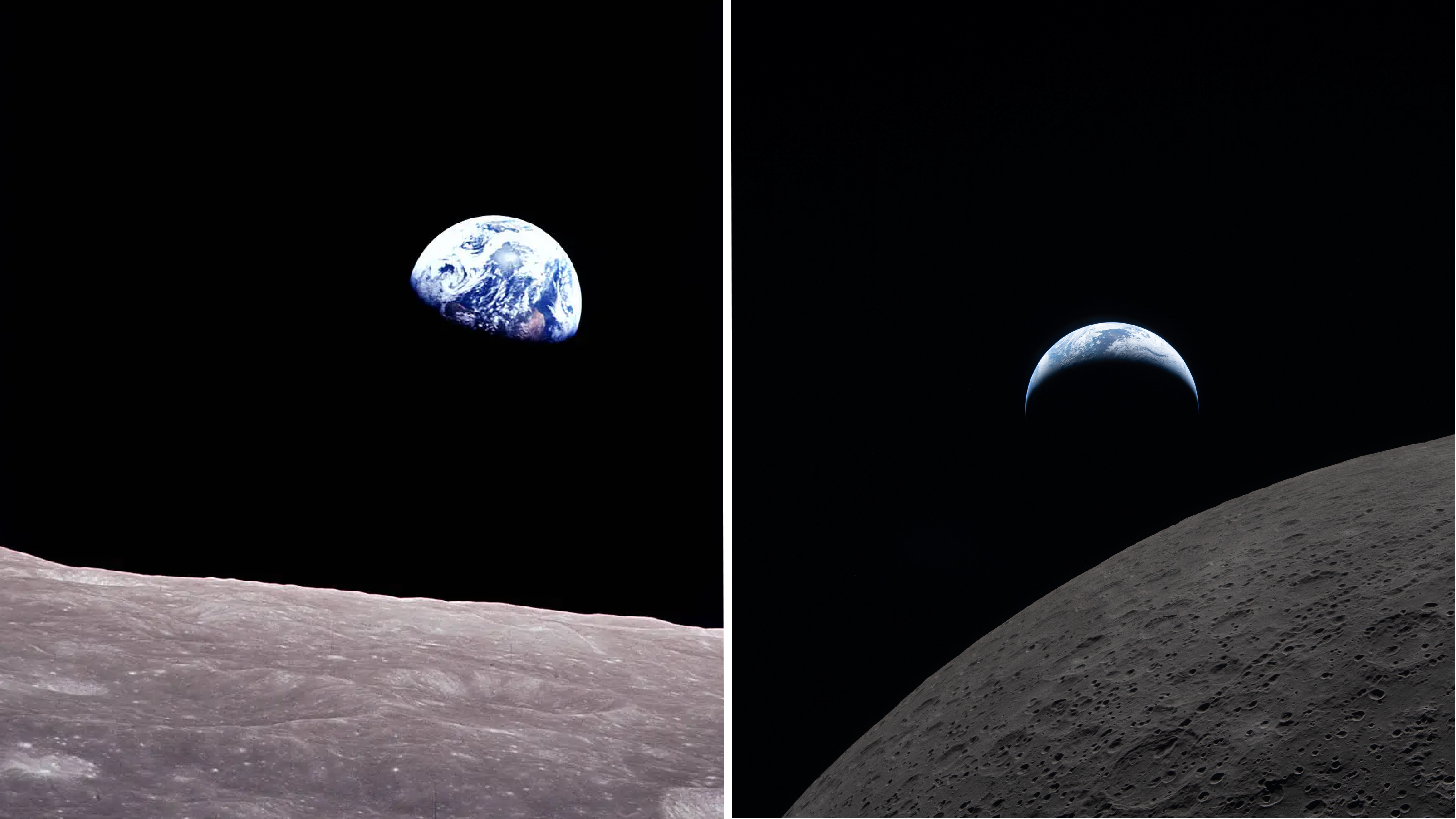
From cameras pressed against spacecraft windows to the most powerful radar ever flown, imaging technology has taken giant leaps since 1968, but the drive to understand our home in the cosmos has remained.
“Our four Artemis II astronauts — Reid, Victor, Christina and Jeremy — took humanity on a journey that showed us just how special and bright our Earth is, even from the dark side of the Moon, that is especially worth celebrating on Earth Day,” said Nicky Fox, associate administrator of the Science Mission Directorate at NASA Headquarters in Washington. “Seeing the incredible images of our blue marble planet over time from Apollo 8’s Earthrise to Artemis II’s Earthset, it is not only a symbolic moment of beauty, but like the other images captured during the lunar flyby, Earthset is brimming with incredible science in high definition that will help inform our future Artemis missions on the Moon.”
Here’s a look at how NASA’s view of Earth has advanced since that early image of the planet.
Sea level to soaring A photograph of the greater New Orleans area, including Lake Pontchartrain and its nearly 24-mile causeway, taken by the Apollo 7 crew (left) in 1968. Right: an image created using recent NASA-ISRO Synthetic Aperture Radar (NISAR) data. The various colors indicate wetlands, city streets, and other kinds of land cover, which reflect radar signals differently. NASA/JPL-Caltech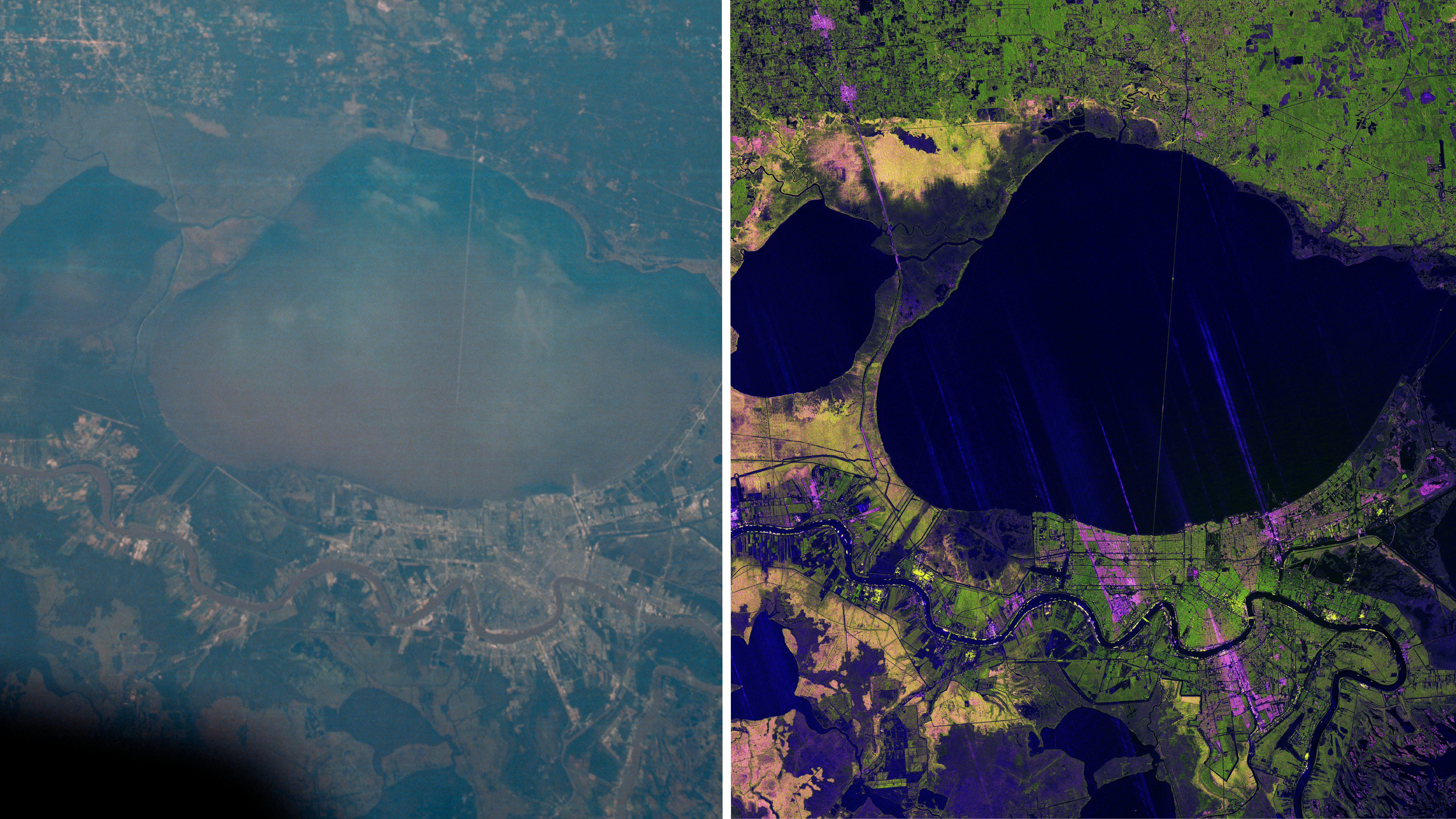
In 1968, during their 120th revolution around the planet, the Apollo 7 astronauts snapped a photo of New Orleans, visible amid the green wetlands and tan sediment of the Mississippi River Delta, some 95 nautical miles below. Today, space-based radar is revealing how the earth beneath our feet is rising, sinking and sliding.
Launched in July 2025 by NASA and the Indian Space Research Organisation (ISRO), NISAR’s (NASA-ISRO Synthetic Aperture Radar) L-band and S-band SAR instruments can penetrate clouds and tree canopies to reveal details of Earth’s surface and observe changes. That’s actionable information for communities, including low-lying cities at risk of losing ground due to rising seas and subsiding land.
The NISAR mission continues a long legacy of Earth-observing satellites. Around the globe, from ice to deserts, NASA’s satellite record has chronicled changes to the human and natural world for decades. See how the recently launched PACE (Plankton, Aerosol, Cloud, and Ocean Ecosystem) satellite captured the Mississippi River Delta swirling with marine life.
“The Artemis photos shared with all of humanity the breathtaking beauty of our home planet, as it can only be seen from space,” said Karen St. Germain, division director, NASA Earth Science Division. “NASA’s fleet of Earth science satellites provide additional dimensions to this beauty, by teaching us how our planet supports the vibrant and dynamic forms of life we see on Earth. This data and discovery help us deliver actionable science so we can continue to thrive on our ever-changing planet.”
Reaching new heights The lofty Himalaya as seen by a Mercury astronaut from his capsule(left) and the Spaceborne Imaging Radar-C/X-band Synthetic Aperture Radar (SIR-C/X-SAR) aboard the space shuttle Endeavour in 1994. Mount Everest is the bright spike right of center in the space shuttle image. NASA/JPL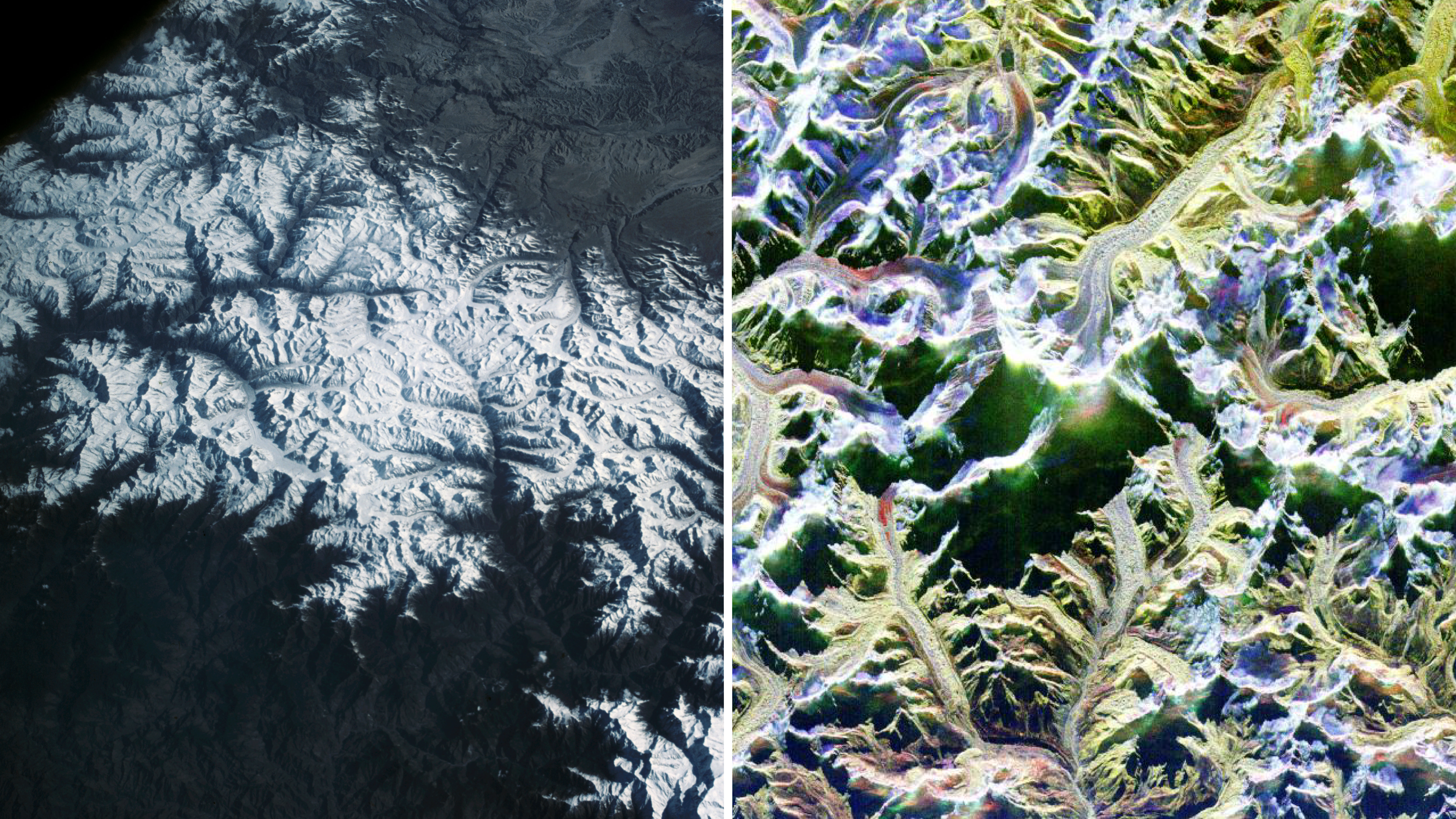
The Himalaya Mountains have captivated astronauts since the early days of the Space Age. Equipped with a handheld 70mm Hasselblad camera, L. Gordon Cooper photographed Mount Everest and its towering neighbors in 1963 while orbiting the planet 22 times alone in his Mercury-Atlas 9 capsule.
By the early 1990s, scientists were tracing the peaks and valleys of the range in spectacular detail using radar aboard the space shuttle. More recently, other space missions and instruments such as ASTER (Advanced Spaceborne Thermal Emission and Reflection Radiometer) and Landsat have aided high-altitude exploration. They’ve helped scientists pinpoint the location of a deadly avalanche on Mount Everest, and track changing plant life across some of the most remote slopes on the planet.
Eye of storm Left: Hurricane Gladys as seen by the Apollo 7 astronauts. Right: NASA’s GPM Core Observatory flew over the center of Super Typhoon Sinlaku on April 12, 2026, providing a detailed look into the structure and intensity of the precipitation. NASA’s Scientific Visualization Studio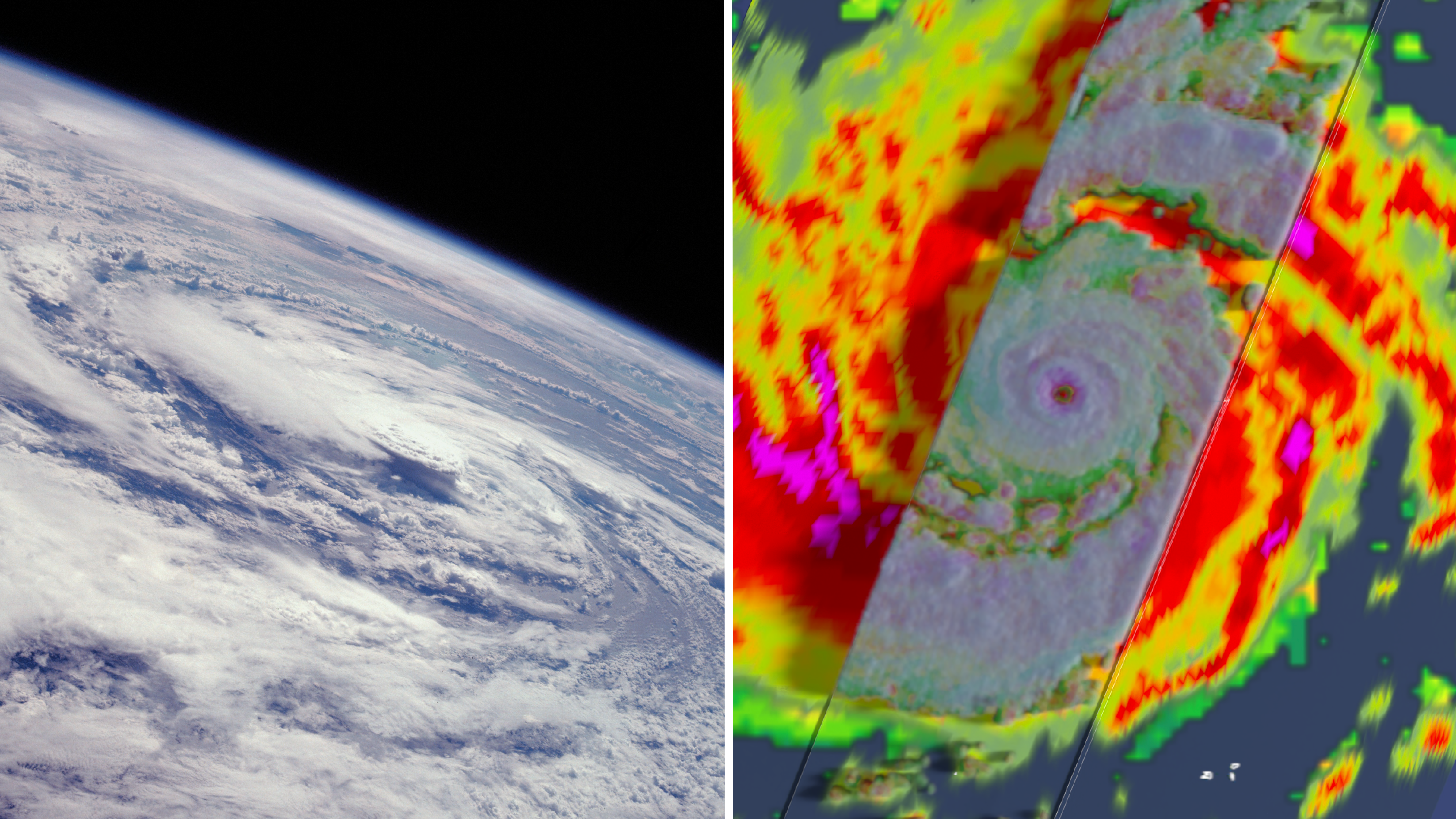
Liftoff of Artemis II on April 1, came exactly 66 years to the day after another milestone launch. The world’s first successful weather satellite — TIROS-1 — sported a pair of television cameras and magnetic tape machines when it rocketed into low Earth orbit in 1960. It provided weather forecasters images of cloud cover from space that improved storm forecasting.
Satellite data complemented the unique photographs captured by Apollo astronauts, who documented hurricanes, thunderheads, and other storm systems roiling beneath their feet. The work continues to this day. Next year, a new generation of radars will take flight as part of the INCUS (Investigation of Convective Updrafts) mission. The three small satellites, flying in tight formation, will help determine why, when, and where severe tropical thunderstorms, heavy precipitation, and clouds occur.
See how a water-watching satellite tracked another kind of natural hazard — a tsunami — speeding across the Pacific Ocean in the wake of a massive earthquake off Russia last July.
Frozen fringes Left: This photograph captured from SkyLab, NASA’s first experimental space station, helped scientists in the early 1970s survey rugged winter terrain in Eastern Canada. Right: the eastern edge of the Antarctic Peninsula and Drygalski Glacier are pictured from a research aircraft in 2017. NASA/Nathan Kurtz
The images above capture two spectacular icescapes a world apart.
The snapshot on the left, taken by a crewmember on the SkyLab space station in 1974, shows plumes of brash ice near Belle Isle off Newfoundland. On the right, new sea ice forms along the coast of Antarctica in an aerial photograph taken during Operation Ice Bridge, NASA’s longest-running airborne mission to observe ice in the North and South polar regions. The findings from that mission, along with satellite laser data, have helped scientists track changes to polar ice sheets since 2003.
In the Arctic, satellites are continually observing how far sea ice retreats season by season and year over year, recording a decades-long trend of less ice cover. On the other side of the globe, in Antarctica, NASA’s MODIS (Moderate Resolution Imaging Spectroradiometer) instrument recently captured the start of summer in full color.
Night, day The Strait of Gibraltar, where the Atlantic Ocean meets the Mediterranean Sea, photographed from the Gemini-5 spacecraft in 1965 (left) and by crew members on the International Space Station in 2014 (right). Astronauts must regularly change out the space station’s cameras because the radiation in space can damage them. NASA/Alex Gerst
Picturing Earth as a blue marble tells only part of our story. Earth at night also teaches us a lot about humanity. Sensors orbiting our planet can resolve light sources down to the scale of a toll booth on a dark highway. By tracking night light illumination, scientists, policymakers and industry can map urban growth, electricity use, and economic activity across the planet.
Compare, for example, the Apollo 11 crew’s view of a shrouded Earth on the day that Neil Armstrong and Buzz Aldrin landed on the Moon in 1969, and this new data visualization based on more than 1 million satellite observations taken every night for nine years.
Left: Apollo 11 command module pilot Michael Collins’ view of Earth on July 20, 1969. Right: a high-resolution visualization created using data from the Visible Infrared Imaging Radiometer Suite (VIIRS) sensors. NASA/Michala Garrison For NASA Earth Observatory
To explore thousands of more photographs, visualizations, videos, and diagrams shared by NASA throughout its history, visit:
Images.nasa.gov
Cropping and contrast on some images in this story have been adjusted.
-Sally Younger
About the Author Sally YoungerShare
Details Last Updated Apr 23, 2026 Related Terms Explore More 3 min read Smoke Shrouds Northern ThailandSeasonal fires have darkened skies over Southeast Asia.
Article
9 hours ago
3 min read Belts of Green in the Washington Suburbs
Along the northeast side of the Capital Beltway in Maryland, green spaces weave through the…
Article
1 day ago
1 min read New NASA Views of Earth, From (S)PACE
NASA has a fleet of satellites in orbit, gathering data around the clock, to explore…
Article
2 days ago
Keep Exploring Discover More Topics From NASA Earth
Your home. Our Mission. And the one planet that NASA studies more than any other.
Earth Observatory
NASA’s Earth Observatory brings you the Earth, every day: images, stories, and discoveries about the environment, Earth systems, and climate.
Explore Earth Science
Earth Science in Action
NASA’s unique vantage point helps us inform solutions to enhance decision-making, improve livelihoods, and protect our planet.
Advancing Earth Observation at NASA Since Release of Earthrise Photo
- Earth
- Explore
- Science at Work
- Multimedia
- Data
- For Researchers
- About Us
6 min read
Advancing Earth Observation at NASA Since Release of Earthrise Photo A crescent Earth captured through the windows of the Orion spacecraft by the Artemis II crew, shortly after they set a new record for the farthest humans have ever traveled from the planet as they flew around the far side of the Moon. NASAWhen NASA’s Apollo 8 crew rounded the far side of the Moon in 1968 and astronaut Bill Anders snapped a picture of Earth peeking above the gray horizon, the image became a symbol of hope in challenging times. The photograph, Earthrise, as it came to be called, helped inspire the first Earth Day celebration two years later.
This year, the astronauts of the Artemis II mission captured their own poignant images of home. The newly released photo shows Earth on April 6, as the crew traveled farther than any humans before them.
“On Earth Day, we are reminded of the extraordinary responsibility we share to understand our planet,” said NASA Administrator Jared Isaacman. “NASA’s Earth science missions continue to deliver critical data that strengthen communities, support industries like agriculture, and help the nation anticipate and respond to wildfires, droughts, flooding, and other natural hazards. Together with our Earth science partners, NASA is committed to deepening our understanding of Earth.”
Left: Earthrise on Dec. 24, 1968, memorialized by the Apollo 8 crew in Kodak Ektachrome color film. Right: A crescent Earth hovers just above the lunar surface, minutes before Earthset. This photo was captured on April 6, by the Artemis II crewmembers through the windows of the Orion spacecraft shortly before they flew behind the Moon and journeyed farther from Earth than any other humans have traveled. NASAFrom cameras pressed against spacecraft windows to the most powerful radar ever flown, imaging technology has taken giant leaps since 1968, but the drive to understand our home in the cosmos has remained.
“Our four Artemis II astronauts — Reid, Victor, Christina and Jeremy — took humanity on a journey that showed us just how special and bright our Earth is, even from the dark side of the Moon, that is especially worth celebrating on Earth Day,” said Nicky Fox, associate administrator of the Science Mission Directorate at NASA Headquarters in Washington. “Seeing the incredible images of our blue marble planet over time from Apollo 8’s Earthrise to Artemis II’s Earthset, it is not only a symbolic moment of beauty, but like the other images captured during the lunar flyby, Earthset is brimming with incredible science in high definition that will help inform our future Artemis missions on the Moon.”
Here’s a look at how NASA’s view of Earth has advanced since that early image of the planet.
Sea level to soaring A photograph of the greater New Orleans area, including Lake Pontchartrain and its nearly 24-mile causeway, taken by the Apollo 7 crew (left) in 1968. Right: an image created using recent NASA-ISRO Synthetic Aperture Radar (NISAR) data. The various colors indicate wetlands, city streets, and other kinds of land cover, which reflect radar signals differently. NASA/JPL-CaltechIn 1968, during their 120th revolution around the planet, the Apollo 7 astronauts snapped a photo of New Orleans, visible amid the green wetlands and tan sediment of the Mississippi River Delta, some 95 nautical miles below. Today, space-based radar is revealing how the earth beneath our feet is rising, sinking and sliding.
Launched in July 2025 by NASA and the Indian Space Research Organisation (ISRO), NISAR’s (NASA-ISRO Synthetic Aperture Radar) L-band and S-band SAR instruments can penetrate clouds and tree canopies to reveal details of Earth’s surface and observe changes. That’s actionable information for communities, including low-lying cities at risk of losing ground due to rising seas and subsiding land.
The NISAR mission continues a long legacy of Earth-observing satellites. Around the globe, from ice to deserts, NASA’s satellite record has chronicled changes to the human and natural world for decades. See how the recently launched PACE (Plankton, Aerosol, Cloud, and Ocean Ecosystem) satellite captured the Mississippi River Delta swirling with marine life.
“The Artemis photos shared with all of humanity the breathtaking beauty of our home planet, as it can only be seen from space,” said Karen St. Germain, division director, NASA Earth Science Division. “NASA’s fleet of Earth science satellites provide additional dimensions to this beauty, by teaching us how our planet supports the vibrant and dynamic forms of life we see on Earth. This data and discovery help us deliver actionable science so we can continue to thrive on our ever-changing planet.”
Reaching new heights The lofty Himalaya as seen by a Mercury astronaut from his capsule(left) and the Spaceborne Imaging Radar-C/X-band Synthetic Aperture Radar (SIR-C/X-SAR) aboard the space shuttle Endeavour in 1994. Mount Everest is the bright spike right of center in the space shuttle image. NASA/JPLThe Himalaya Mountains have captivated astronauts since the early days of the Space Age. Equipped with a handheld 70mm Hasselblad camera, L. Gordon Cooper photographed Mount Everest and its towering neighbors in 1963 while orbiting the planet 22 times alone in his Mercury-Atlas 9 capsule.
By the early 1990s, scientists were tracing the peaks and valleys of the range in spectacular detail using radar aboard the space shuttle. More recently, other space missions and instruments such as ASTER (Advanced Spaceborne Thermal Emission and Reflection Radiometer) and Landsat have aided high-altitude exploration. They’ve helped scientists pinpoint the location of a deadly avalanche on Mount Everest, and track changing plant life across some of the most remote slopes on the planet.
Eye of storm Left: Hurricane Gladys as seen by the Apollo 7 astronauts. Right: NASA’s GPM Core Observatory flew over the center of Super Typhoon Sinlaku on April 12, 2026, providing a detailed look into the structure and intensity of the precipitation. NASA’s Scientific Visualization StudioLiftoff of Artemis II on April 1, came exactly 66 years to the day after another milestone launch. The world’s first successful weather satellite — TIROS-1 — sported a pair of television cameras and magnetic tape machines when it rocketed into low Earth orbit in 1960. It provided weather forecasters images of cloud cover from space that improved storm forecasting.
Satellite data complemented the unique photographs captured by Apollo astronauts, who documented hurricanes, thunderheads, and other storm systems roiling beneath their feet. The work continues to this day. Next year, a new generation of radars will take flight as part of the INCUS (Investigation of Convective Updrafts) mission. The three small satellites, flying in tight formation, will help determine why, when, and where severe tropical thunderstorms, heavy precipitation, and clouds occur.
See how a water-watching satellite tracked another kind of natural hazard — a tsunami — speeding across the Pacific Ocean in the wake of a massive earthquake off Russia last July.
Frozen fringes Left: This photograph captured from SkyLab, NASA’s first experimental space station, helped scientists in the early 1970s survey rugged winter terrain in Eastern Canada. Right: the eastern edge of the Antarctic Peninsula and Drygalski Glacier are pictured from a research aircraft in 2017. NASA/Nathan KurtzThe images above capture two spectacular icescapes a world apart.
The snapshot on the left, taken by a crewmember on the SkyLab space station in 1974, shows plumes of brash ice near Belle Isle off Newfoundland. On the right, new sea ice forms along the coast of Antarctica in an aerial photograph taken during Operation Ice Bridge, NASA’s longest-running airborne mission to observe ice in the North and South polar regions. The findings from that mission, along with satellite laser data, have helped scientists track changes to polar ice sheets since 2003.
In the Arctic, satellites are continually observing how far sea ice retreats season by season and year over year, recording a decades-long trend of less ice cover. On the other side of the globe, in Antarctica, NASA’s MODIS (Moderate Resolution Imaging Spectroradiometer) instrument recently captured the start of summer in full color.
Night, day The Strait of Gibraltar, where the Atlantic Ocean meets the Mediterranean Sea, photographed from the Gemini-5 spacecraft in 1965 (left) and by crew members on the International Space Station in 2014 (right). Astronauts must regularly change out the space station’s cameras because the radiation in space can damage them. NASA/Alex GerstPicturing Earth as a blue marble tells only part of our story. Earth at night also teaches us a lot about humanity. Sensors orbiting our planet can resolve light sources down to the scale of a toll booth on a dark highway. By tracking night light illumination, scientists, policymakers and industry can map urban growth, electricity use, and economic activity across the planet.
Compare, for example, the Apollo 11 crew’s view of a shrouded Earth on the day that Neil Armstrong and Buzz Aldrin landed on the Moon in 1969, and this new data visualization based on more than 1 million satellite observations taken every night for nine years.
Left: Apollo 11 command module pilot Michael Collins’ view of Earth on July 20, 1969. Right: a high-resolution visualization created using data from the Visible Infrared Imaging Radiometer Suite (VIIRS) sensors. NASA/Michala Garrison For NASA Earth ObservatoryTo explore thousands of more photographs, visualizations, videos, and diagrams shared by NASA throughout its history, visit:
Images.nasa.gov
Cropping and contrast on some images in this story have been adjusted.
-Sally Younger
About the Author Sally YoungerShare
Details Last Updated Apr 22, 2026 Related Terms Explore More 3 min read Belts of Green in the Washington SuburbsAlong the northeast side of the Capital Beltway in Maryland, green spaces weave through the…
Article
11 hours ago
1 min read New NASA Views of Earth, From (S)PACE
NASA has a fleet of satellites in orbit, gathering data around the clock, to explore…
Article
18 hours ago
4 min read A School of Mud Volcano Islands in Azerbaijan
The tadpole-shaped islands along the Absheron Peninsula were born by explosive mud volcano eruptions and…
Article
1 day ago
Keep Exploring Discover More Topics From NASA Earth
Your home. Our Mission. And the one planet that NASA studies more than any other.
Earth Observatory
NASA’s Earth Observatory brings you the Earth, every day: images, stories, and discoveries about the environment, Earth systems, and climate.
Explore Earth Science
Earth Science in Action
NASA’s unique vantage point helps us inform solutions to enhance decision-making, improve livelihoods, and protect our planet.
Sun-Observing Satellite Uses Artificial Eclipse to Capture the Solar Wind
The Proba 3 mission flies two spacecraft in precise formation to create an artificial eclipse and obtain close views of the solar wind as it leaves the Sun.
The post Sun-Observing Satellite Uses Artificial Eclipse to Capture the Solar Wind appeared first on Sky & Telescope.
Fermat's Last Theorem: still a must-read about a 350-year maths secret
Fermat's Last Theorem: still a must-read about a 350-year maths secret
ESA School Days 2026: A week of space and science
English
From 13 to 17 April, ESA’s Centre for Earth Observation in Frascati, ESRIN, hosted the 2026 edition of ESA School Days, welcoming students from across Italy for a week dedicated to space and science.
Throughout the week, participants took part in presentations, interactive laboratories and hands-on activities, exploring how ESA studies our planet and the wider Universe. Activities included: sessions dedicated to European launchers, Ariane 6 and Vega C, as well as the future reusable vehicle Space Rider, model rocket launch demonstrations, as well as meteorite and asteroid workshops and guided visits to the Earth Observation Multimedia Centre. This initiative aimed to inspire younger generations by raising awareness of scientific research, environmental protection and climate change, while fostering curiosity, teamwork and interest in STEM disciplines. The event was organised with contributions from ESERO Italia and the Italian Space Agency.
Italiano
Dal 13 al 17 aprile, ESRIN, il Centro dell’Agenzia Spaziale Europea dedicato ai Programmi di Osservazione della Terra a Frascati, ha ospitato l’edizione 2026 degli ESA School Days, accogliendo studenti provenienti da tutta Italia per una settimana dedicata allo spazio e alla scienza.
Durante la settimana, i partecipanti hanno preso parte a presentazioni, laboratori interattivi ed esperienze pratiche, esplorando come l’ESA studia la Terra e indaga l’Universo. Tra le attività: sessioni dedicate ai lanciatori europei, Ariane 6 e Vega C ed al futuro veicolo riutilizzabile Space Rider, dimostrazioni di lancio di razzi-modello, laboratori su meteoriti e asteroidi e visite guidate al Centro Multimediale di Osservazione della Terra. L’iniziativa ha avuto l’obiettivo di ispirare le giovani generazioni, sensibilizzandole su temi come la ricerca scientifica, la tutela dell’ambiente e il cambiamento climatico, promuovendo curiosità, lavoro di squadra e interesse verso le discipline STEM. L’evento è stato realizzato con il contributo di ESERO Italia e dell’Agenzia Spaziale Italiana.
A humanoid robot beat the human half-marathon record at a Beijing race. But what did it actually prove?
A premapped course, a crew of handlers and a world-beating time: here’s what this Beijing half marathon reveals about how far humanoid robots have come—and how far they haven’t
NASA’s ‘Earthrise’ image changed how we see our planet. Can the Artemis moon missions do the same?
Fresh takes on Apollo’s famous “Earthrise” and “Blue Marble” images showed off our planet’s beauty just weeks before Earth Day
Mars Didn't Have Bathtubs, It Had Shelves
Scientists have been debating for decades whether Mars once held a vast ocean covering a large part of its northern face. To prove the idea, they’ve been looking for a “bathtub ring” - a distinct, level shoreline that shows where water once stood. But, despite years of looking, they’ve only been able to find a very distorted potential shoreline whose height deviates by several kilometers - not exactly great evidence of a stable water level. But, according to a new paper in Nature from Abdallah Zaki and Michael Lamb of CalTech, what scientists should have been looking for wasn’t a bathtub ring, but a continental shelf.
Whatever happened to the ozone hole, acid rain and DDT?
The environmental crises of the past often seem to disappear—have problems like acid rain and smog been solved?
This Earth Day, three experts share tips on how to feel hopeful about the environment
This Earth Day three environmental experts share stories about times when environmental action succeeded in saving the planet—and explain why this can be done again
Gibraltar macaques are self-medicating with dirt to help them digest human junk food
Gibraltar’s macaques have been observed engaging in geophagy, the consumption of soil and clay, in an apparent attempt to quell their nausea from eating fatty and salty foods offered by tourists
Turning data from space into action for Earth
Happy Earth Day, 22 April – a global call to act and protect our planet. At the European Space Agency, that action begins in orbit, where satellites deliver a continuous, global view of Earth and track environmental change. Working with partners, ESA turns this stream of data into actionable information through its FutureEO programme, helping governments and communities respond faster and more effectively to climate-driven risks.
Here are two examples of how space technology is being used to anticipate threats to safeguard food security and public health.
Belts of Green in the Washington Suburbs
- Earth
- Earth Observatory
- Image of the Day
- EO Explorer
- Topics
- More Content
- About
Belts of Green in the Washington Suburbs
- Earth
- Earth Observatory
- Image of the Day
- EO Explorer
- Topics
- More Content
- About
Stellar Flares May Expand Habitable Zones Around Small Stars
The search for life beyond Earth has traditionally focused on exoplanets orbiting Sun-like stars, which is a G-type star. However, low-mass stars, which are designated as K-type and M-type stars, have rapidly become a target for astrobiology, primarily due to their much longer lifetimes. This also means the habitable zone (HZ), which is the distance from a star where liquid water could exist, is much smaller than our solar system’s HZ, and is referred to as the liquid water habitable zone (LW-HZ). In contrast, another type of HZ that involves a star’s ultraviolet (UV) radiation potentially enabling life-harboring conditions is known as UV-HZ.
Artemis II Mission Milestones: An Image and Video Recap
On April 1, 2026, Artemis II launched on a nearly 10-day voyage around the Moon, marking the first crewed flight of NASA’s Orion spacecraft. NASA astronauts Reid Wiseman, Victor Glover, and Christina Koch, along with CSA (Canadian Space Agency) astronaut Jeremy Hansen, splashed down on April 10 in the Pacific Ocean off the coast of San Diego.
At their farthest point, the crew traveled 252,756 miles from Earth, setting a record for the greatest distance humans have traveled in space and observing the lunar surface like never before.
Under Artemis, NASA will send astronauts on increasingly complex missions to explore the Moon for scientific discovery, economic benefit, and to prepare for future human missions to Mars.
Relive exciting mission moments through the videos and images shared below.
Pre-Launch Preparation The Artemis II crew and backup crew members NASA astronaut Andre Douglas and CSA (Canadian Space Agency) astronaut Jenni Gibbons trek across the Icelandic landscape during their field geology training.NASA/Robert Markowitz
To prepare for lunar exploration, the Artemis II crew trained in Iceland’s volcanic terrain.
They practiced navigation and field geology skills in challenging conditions while working as a team. The astronauts collected rock samples using tools like hammers, scoops, and chisels, and provided feedback to instructors to refine future Artemis training sites.
Orion Crew Survival System (OCSS) suit long-duration fit check with Artemis II Commander Reid Wiseman. NASA/Josh Valcarcel NASA/Josh Valcarcel
The crew trained extensively in NASA’s Orion Crew Survival System (OCSS), the bright orange spacesuit worn inside the Orion spacecraft during launch and re-entry.
Each suit is custom-fitted and includes systems for air, water, food, and waste management. In emergencies, it can sustain life for up to six days.
The crew practiced suit operations in simulated weightlessness and pressurized environments to confirm performance for deep space travel.
During the mission, the crew reflected on what the Moon means to them personally and professionally, sharing thoughts shaped by years of training and preparation.
Launch NASA’s SLS (Space Launch System) rocket carrying the Orion spacecraft with NASA astronauts Reid Wiseman, Victor Glover, and Christina Koch, along with CSA (Canadian Space Agency) astronaut Jeremy Hansen launched April 1, 2026, from Launch Complex 39B at NASA’s Kennedy Space Center in Florida. NASA/Bill Ingalls NASA/Keegan Barber
Launch of NASA’s Artemis II: Moon Rocket Camera Views
Enjoy launch views from cameras affixed to the SLS (Space Launch System) rocket. These cameras, developed by NASA, are called the Flight Imaging Launch Monitoring Real-time System (FILMRS). They survive some of the harshest environments of the avionics on the vehicle.
Mission to the MoonFlight Day Highlights
Flight Day 1This black and white image of Earth was captured by the optical navigation sensor on the exterior of the Orion spacecraft on the first day of the Artemis II mission, as the quartet inside were traveling farther than any humans have ventured in more than 50 years.NASA Flight Day 2A view of Earth taken by an Artemis II astronaut from one of the Orion spacecraft’s four windows after completing the translunar injection burn.NASA Flight Day 3View of a crescent Earth from the Orion spacecraft. NASA Flight Day 4Artemis II Mission Specialist Christina Koch is seen through a window of the Orion spacecraft while on her way to the Moon. This selfie-style photo was taken using a camera on the end of one of Orion’s solar array wings. Koch is holding “Rise”, the zero gravity indicator that launched with the crew after being selected from more than 2,600 original designs that were submitted from countries around the world. A zero gravity indicator is a small plush item that typically rides with a crew to visually indicate when they are in space. “Rise” was inspired by the iconic Earthrise moment from the Apollo 8 mission.NASA Flight Day 5A view of the nearside of the Moon, the side we always see from Earth. Some of the far side is visible, as well, on the left edge, just beyond the black patch that is Orientale basin, a nearly 600-mile-wide crater that straddles the Moon’s near and far sides and is partly visible from Earth. The dark areas in the center and right side of the disk are ancient lava flows, which are unique to the near side of the Moon. The white dot at the bottom of the disk, with white rays shooting out from it, is Tycho crater, one of the younger craters on the Moon at 108 million years old.NASA Flight Day 6Earth sets at 5:41 p.m. CDT, April 6, 2026, over the Moon’s curved limb in this photo captured by the Artemis II crew during their journey around the far side of the Moon. Orientale Basin is perched on the edge of the visible lunar surface. Hertzsprung Basin appears as two subtle concentric rings, which are interrupted by Vavilov, a younger crater superimposed over the older structure. The lines of indentations are secondary crater chains formed by ejecta from the massive impact that created Orientale. The dark portion of Earth is experiencing nighttime. On Earth’s day side, swirling clouds are visible over the Australia and Oceania region.NASA Flight Day 6Echoing the iconic Earthrise photo captured by the Apollo 8 astronauts in 1968, during the lunar flyby, the Artemis II crew captured a shot of Earthset as they passed behind the Moon’s far side.NASA Flight Day 6Seen from behind the Moon during Artemis II, the Moon and Earth align in the same frame, each partially illuminated by the Sun. The Moon’s surface appears in sharp detail in the foreground, while Earth sits much farther away, smaller and softly lit in the background. A faint reflection in the spacecraft window is also visible, subtly overlaying the scene. Though their phases differ, both are shaped by the same sunlight, revealing the geometry of the Sun–Earth–Moon system from deep space.NASA Flight Day 6The Moon, backlit by the Sun during a solar eclipse, is photographed by NASA’s Orion spacecraft on April 6, 2026, during the Artemis II mission. Orion is visible in the foreground on the left. Earth is reflecting sunlight at the left edge of the Moon, which is slightly brighter than the rest of the disk. The bright spot visible just below the Moon’s bottom right edge is Saturn. Beyond that, the bright spot at the right edge of the image is Mars.NASA Flight Day 6 Solar array wing-mounted cameras capture close-up images of NASA’s Orion spacecraft during a routine external inspection. At the time this photo was taken at 7:27 a.m. CDT, April 7, the crew was in a sleep period ahead of their seventh day into the mission.NASA Flight Day 7A stunning snapshot in time. The Artemis II crew captured this breathtaking photo of our galaxy, the Milky Way. The Milky Way’s elegant spiral structure is dominated by just two arms wrapping off the ends of a central bar of stars. Spanning more than 100,000 light-years, Earth is located along one of the galaxy’s spiral arms, about halfway from the center.NASA Flight Day 7 The Artemis II crew – (clockwise from left) Mission Specialist Christina Koch, Mission Specialist Jeremy Hansen, Commander Reid Wiseman, and Pilot Victor Glover – pause for a group photo with their zero gravity indicator “Rise,” inside the Orion spacecraft on their way home.NASA Flight Day 10On April 10, 2026, NASA’s Artemis II crew members are hoisted into a U.S. Navy MH-60 helicopter after successfully splashing down in the Pacific Ocean following their nearly 10-day mission around the Moon.NASA/James Blair Flight Day 10On April 10, 2026, NASA’s Artemis II crew members are hoisted into a U.S. Navy MH-60 helicopter after successfully splashing down in the Pacific Ocean following their nearly 10-day mission around the Moon.NASA/James BlairReturn to Earth
After splashdown in the Pacific Ocean, NASA and U.S. Navy teams recovered the Orion spacecraft and crew.
Recovery teams secured the capsule, opened the hatch, and assisted the astronauts out. The crew was then flown by helicopter to the Navy recovery ship, while Orion was brought aboard for transport back to shore.
More Mission Moments NASA astronaut and Artemis II Mission Specialist Christina Koch peers out of one of the Orion spacecraft’s main cabin windows, looking back at Earth, as the crew travels toward the Moon.NASA
View more imagery on the Artemis II Multimedia Resource Page.
Go/No-Go: NASA’s Space Toilet Explained
The Universal Waste Management System, or space toilet, is a critical onboard system.
During the mission, the crew worked through operational issues to maintain performance in microgravity.
Space-to-Space Call: NASA’s Artemis II Astronauts and the International Space Station
Members of the International Space Station Expedition 74 (left) and Artemis II (right) crews are seen at once on the screens inside the International Space Station flight control room in the Mission Control Center at NASA’s Johnson Space Center in Houston. NASA/Robert Markowitz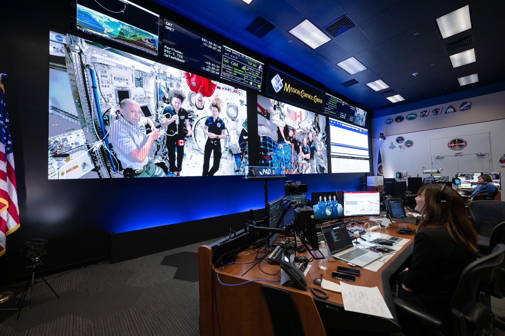
A historic first took place during the mission: a direct call between a deep space crew and astronauts aboard the International Space Station.
Artemis II connected with Expedition 74 astronauts Chris Williams, Jack Hathaway, Jessica Meir, and ESA (European Space Agency) astronaut Sophie Adenot, marking the first ship-to-ship communication of its kind.
The Artemis II crew uses eclipse viewers, identical to what NASA produced for the 2023 annular eclipse and 2024 total solar eclipse, to protect their eyes at key moments during the solar eclipse they experienced during their lunar flyby. This was the first use of eclipse glasses at the Moon to safely view a solar eclipse.NASA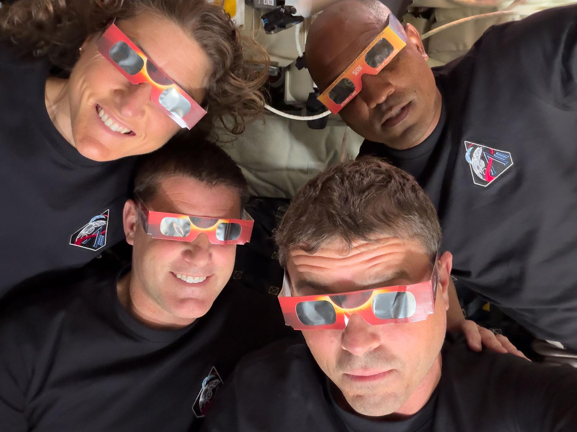
Artemis II brought the crew to 252,756 miles from Earth at its farthest point and covered a total of 694,481 miles.
The lunar flyby set a new human distance record, surpassing Apollo 13’s 1970 record. The crew observed the Moon from closer range than any humans before them during a crewed mission.
Moon Joy, Courtesy of NASA’s Artemis II Astronauts
The Artemis II crew – (clockwise from left) Mission Specialist Christina Koch, Mission Specialist Jeremy Hansen, Commander Reid Wiseman, and Pilot Victor Glover – pause for a group photo with their zero gravity indicator “Rise,” inside the Orion spacecraft on their way home.NASA
With years of training and thousands of experts behind the mission, one unexpected outcome stood out: Moon joy.
It captured the emotional weight of seeing the Moon up close and the significance of returning humans to deep space.
Watch the official NASA broadcast as the Artemis II crew splashes down in the Pacific Ocean.
NASA’s Orion capsule descends under its main parachutes over the Pacific Ocean following a successful Artemis II mission, April 10, 2026.NASA/Josh Valcarcel NASA’s Artemis II crew shared remarks with friends, family, and colleagues after they landed at Ellington Airport on April 11, 2026.NASA/Helen Arase Vargas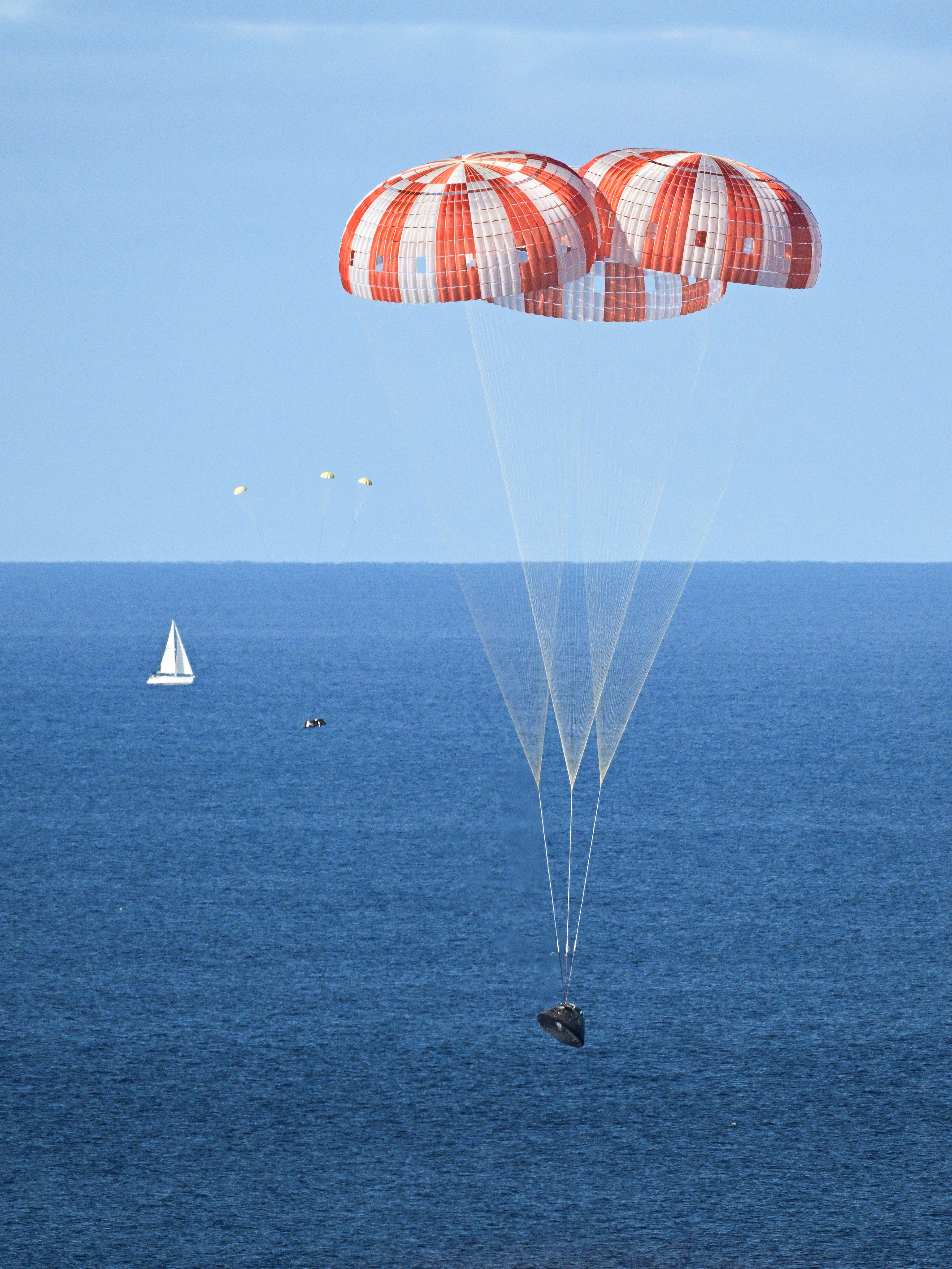
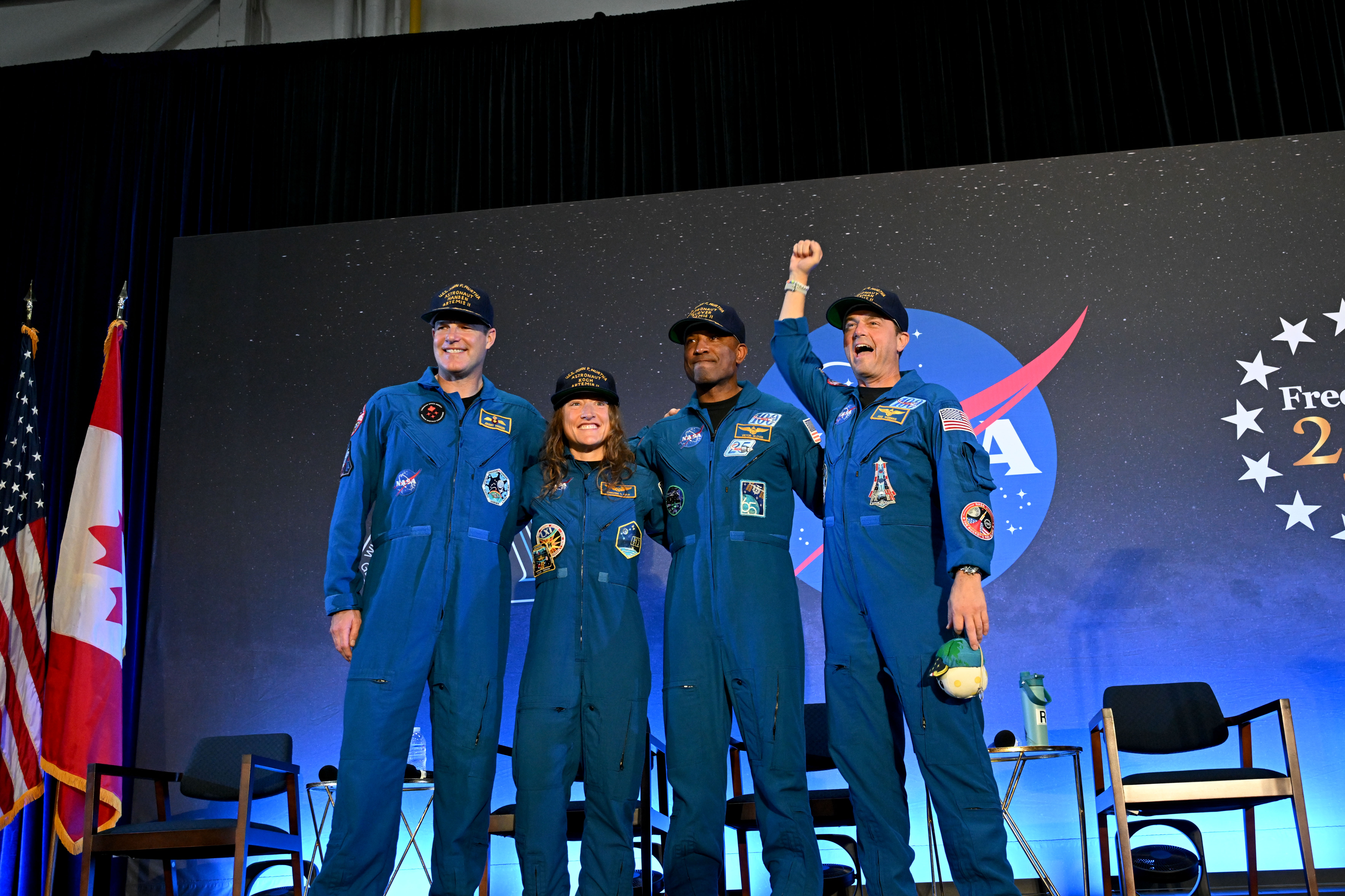
The Artemis II astronauts returned to Ellington Airport in Houston following their historic mission around the Moon.
Artemis II Crew News Conference
The crew shared reflections on their journey, the challenges of deep space flight, and what comes next for Artemis.
The Artemis II mission marks a major step forward in human exploration.
The mission demonstrated deep space crew operations, tested Orion systems with astronauts aboard, and set the stage for future lunar missions.
We are just getting started.
The Next Steps in Lunar Exploration As the Artemis II crew flew over the terminator, the astronauts described this boundary between day and night as “anything but a straight line.” Crater rims along the terminator stand out as “islands” in the night. Giant chains of craters emanating from the 3.7-billion-year-old Orientale Basin can be seen scouring the surface, stretching almost to the terminator. This tells a geologic story: these crater chains produced by the Orientale impact event mar the surface of the relatively flat Hertzsprung Basin (center of this image), which means that Hertzsprung Basin must be even older than Orientale.NASA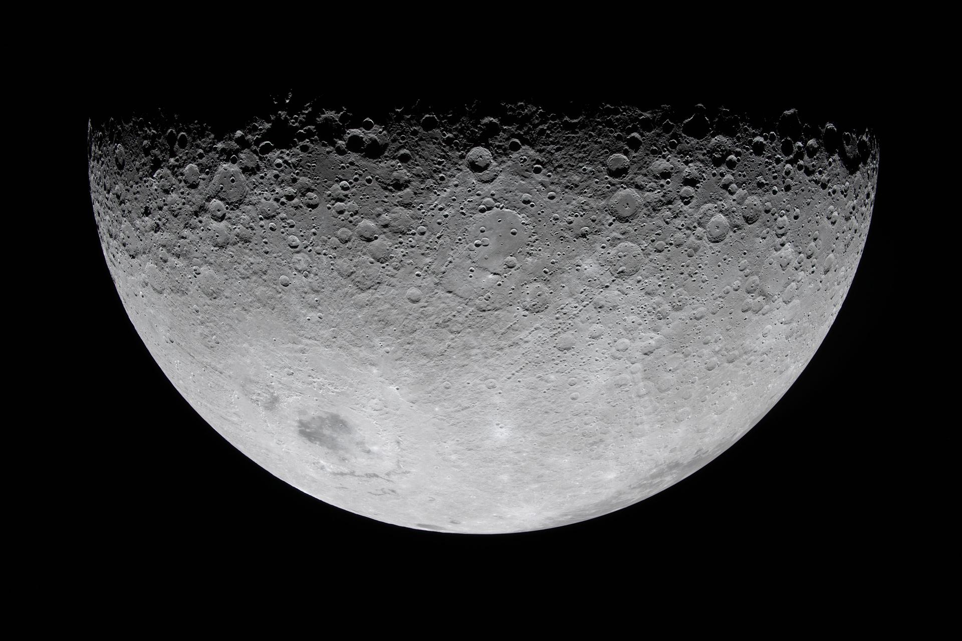
NASA is preparing for future missions to the Moon’s South Pole.
Work continues on next-generation spacesuits, lunar tools, and rovers at Johnson and its supporting training facilities. Listen as Apollo and Artemis astronauts, as well as subject matter experts, discuss the challenges of exploring the Moon in preparation for Mars
Future Artemis missions will face challenges including harsh lighting conditions, lunar dust, and extreme temperatures as NASA builds toward sustained exploration of the Moon and eventual human missions to Mars.
Explore More 1 min read NASA SBIR/STTR Phase I and II BAA, 2026 Appendix A and B are now live! Offers due May 21, 2026, 5:00PM EDT Article 13 hours ago 3 min read NASA’s 777 Aircraft Returns Home with Science Flights on the Horizon Article 15 hours ago 5 min read NASA at SXSW: Johnson Director Vanessa Wyche on Why Artemis Changes Everything Article 2 days ago