
Feed aggregator
Aerospace Medicine Clerkship
5 min read
Preparations for Next Moonwalk Simulations Underway (and Underwater) Aerospace Medicine Clerkship montage of imagesNASA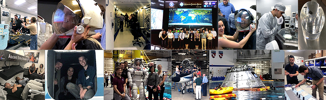
The application window for the April 2025 session is open. The next available session will convene Monday, March 31- Friday, April 25. Applications for the April 2025 session will close on Monday, December 2, 2024 at 1159 CT.
If you have read the FAQ and still have questions, don’t hesitate to get in touch with me via email at amy.n.honors@nasa.gov, as hybrid work schedules are in place at JSC, and office phones may be manned sporadically until further notice.
When submitting your application, electronic submissions are strongly preferred. Please refer to the instructions in the application document and ensure that you are using a secure encrypted platform that may require a password or code to access upon receipt. (O365 is the preferred encryption platform, and if your institution has a similar platform, this may be used as well). Not encrypted applications will not be accepted and must be deleted immediately to adhere to NASA JSC policies to protect and handle your PII accordingly. Also, please confirm application receipt and do not assume your application has been received unless confirmed via email by Amy Honors. Work Tour DescriptionThe four-week Aerospace Medicine Clerkship is offered twice annually during April and October at the Lyndon B. Johnson Space Center (located in Houston, TX) and typically begins the first Monday and concludes on the last Friday of the month. The clerkship involves formal lectures on space medicine topics and issues, familiarization with the medical aspects of International Space Station operations, design, and function as well as Exploration Medical Capability for deep space exploration. Clerkship participants are required to complete a research project and scientific poster with an accompanying 250 word abstract in a current focus area of space medicine, which will be presented in an open forum poster session for not only the JSC Space Medicine Operations and clinical community, but other interested divisions/elements at JSC.
Eligibility Requirements- Interested persons must be a US Citizen (or hold dual citizenship to include the US)
- The MINIMUM educational requirement is to be in your final year of medical school. (residents and attending physicians are eligible to apply)
- Must have an interest in Aerospace Medicine and plan to apply in future career goals
All applicants must include the following:
- Application
- Statement of Interest
- Curriculum vitae (CV)
- A letter of good standing and recommendation from the school or institution and an official transcript (or diploma if applicable) from the medical school is required.
Applications are due June 1st for the October clerkship and December 1st for the April clerkship.
Upon completion of the application period, a maximum of 20 students will be selected for each of the clerkships by a committee of NASA flight surgeons and other Space Medicine Training and or Clinical Operations team members.
Selection is based upon demonstrated interest and career goals involving Aerospace Medicine, academic standing, the content of a Dean’s recommendation (or direct supervisor if graduated) *, research, and work experience.
* Letter can be from the medical school Dean or Departmental Dean. Supervisor letter would apply to those beyond the 4th year and can provide their diploma.
Application File Download Aerospace Medicine Clerkship ApplicationSep 14, 2023
PDF (127.36 KB)
Aerospace Medicine Clerkship group picture at JSC Neutral Buoyancy LabNASA
You must send your application package via a secure email platform. Many institutions have a secure email platform in which I will create an account/password to access your attachments. Please do not submit your application via regular email as I cannot open them and they will be deleted.
***The email platform MUST be secure/encrypted to comply with NASA/JSC policies to protect your Private Identifiable Information (PII) and in order for your application to be accepted.***
If you find it necessary to Mail your application, please use USPS or a courier to send your application to:
Amy N. Honors
NASA Lyndon B. Johnson Space Center
Mail Code SD222
2101 NASA Parkway
Houston, Texas 77058
All costs incurred during the clerkship are your responsibility. NASA JSC or KBR provides no monies for the clerkship.
If selected, to assist with lodging, you will be supplied with access to our local JSC Housing Co-Op as well as recommendations for local hotels, extended stays, and areas to target for AirBnB and VRBO, etc.
You will be supplied with a computer to be used for research purposes only, and access to several collaborative work areas on-site at JSC.
Participants are responsible for their transportation during the clerkship. Participants are also encouraged to carpool with other clerks.
Aerospace Medicine Clerkship participant view altitude chamber at NASA NBL.NASA During The Clerkship
During the clerkship, you will be exposed to a variety of space medicine topics given in presentations, lectures, and tours, such as the medical equipment available to crew members in space, space physiology, radiation monitoring, tours of the training facilities, etc. The daily activities will include both presentations and tours, as well as time for you to work on your project. The schedules are always subject to change. You will be present/available M-F 8:00 am – 5:00 pm. (40 hrs/week) and no required activities scheduled on the weekends.
This clerkship is considered an educational/research clerkship and is non-clinical. Therefore, contact/interaction with patients during the clerkship should not be expected.
Point of ContactAmy Honors 281-483-7050
Additional Resources for Aerospace MedicineBelow are additional resources for Aerospace Medicine knowledge and networking, some of which may also provide opportunities for non-U.S. citizens.**
- Aerospace Medical Association (AsMA)
- Aerospace Medicine Student and Resident Organization (AMSRO)
- University of Texas Medical Branch Principles of Aviation and Space Medicine Short course. Information: 4-week course, also 4th/final year of medical school eligibility. DOES accept foreign national applications. It has many aspects that are not in the clerkship, such as commercial spaceflight and general aviation medicine.
- NASA Internships – wide range of opportunities.
Aerospace Medicine Clerkship FAQ’s (PDF, 190KB)
Education and Outreach Share Details Last Updated Sep 30, 2024 EditorRobert E. LewisLocationJohnson Space Center Related Terms Explore More 2 min read Book on Space Nutrition Article 1 year ago Keep Exploring Discover More Topics From NASAHumans In Space
Missions
International Space Station
Solar System
Summary of the 10th SWOT Applications Workshop
21 min read
Summary of the 10th SWOT Applications WorkshopIntroduction
The tenth Surface Water Ocean Topography (SWOT) Applications Workshop took place December 7–8, 2023 at the California Institute of Technology Keck Institute for Space Studies. The meeting was organized to highlight the work and project status of the SWOT Early Adopters (EAs). NASA’s Applied Sciences Program (which is now housed within the NASA Earth Science in Action element of NASA’s Earth Science Division), the SWOT Project, the Centre National d’Etudes Spatiales (CNES’s), or French space agency’s SWOT Downstream Program, the SWOT Applications Working Group (SAWG), and members of the SWOT science community have coordinated efforts in support of the SWOT Applications Program since 2010.
The 2023 meeting, which was the latest in an annual series organized by the SAWG, welcomed over 100 participants online and in person during the two days, with many joining virtually across different time zones, to share their project status and explore the many facets of operational and applied uses of SWOT data. Presentations covered the current state of and near-term plans for using SWOT data products and highlighted related applied science efforts focused on SWOT. A significant focus explored the use of the new mission data to improve hydrology and ocean models.
After a brief introduction to SWOT and its instruments and a short update on the SWOT EAs, the remainder of this article contains a select group of summaries from EA projects. The complete meeting agenda and a list of presentations are available on the 10th SWOT Application Meeting website.
SWOT Mission Overview and Update
SWOT launched December 16, 2022, from Vandenberg Space Force Base in California. After a successful checkout of the satellite systems, instruments, and data systems, SWOT entered Science Mode on July 21, 2023. It continues to operate nominally as of this writing. A detailed account of SWOT Significant Events since launch is available online.
The goal of SWOT is to make the first global survey of Earth’s surface water, observe the fine details of the ocean’s surface topography, and measure how water bodies change over time. The international partnership is led by NASA and CNES, with contributions from the U.K. Space Agency and the Canadian Space Agency.
The SWOT Science Team is made up of researchers from all over the world with expertise in oceanography and hydrology. Together the team is using SWOT data to study a range of topics, including availability of Earth’s freshwater resources and our changing ocean and coasts. Studies like these are crucial to meet society’s growing needs for clean air and water, to help prepare for and mitigate impacts of extreme weather, and to help the world adapt to long-term changes in climate on continental scales.
SWOT’s payload has been designed to provide the data that allow the SWOT team to study the topics listed in the previous paragraph. While the complete compliment of instruments is listed on the website, the three most relevant to the current article are described here.
- Ka-band Radar Interferometer (KaRIn). This state-of-the-art, wide-swath, interferometric radar can measure the ocean, major lake, river, and wetland levels over a 120-km (75-mi) wide swath with a ~20-km (~12-mi) gap along nadir, which is filled by the Jason-class altimeter described below. KaRIn can operate in two modes: It uses low-resolution mode over the ocean with significant onboard processing to reduce data volume; and high-resolution mode over broad, primarily continental regions defined by the SWOT Science Team, where the focus is on hydrological studies as opposed to oceanographic ones.
- Jason-class Altimeter (nadir altimeter). The altimeter flying on SWOT is similar to those flown on the series of ocean surface topography missions that have operated since 1992, including the (TOPEX)/Poseidon, Jason-1, Jason-2, and Jason-3 missions, and the newest mission, Sentinel 6 Michael Freilich (S6MF), developed in partnership with the European Space Agency (ESA). The altimeter sends and receives signals that travel straight up and down beneath the spacecraft (or nadir-pointing) making it ideal to fill in the “gap” between KaRIn swaths.
- Microwave Radiometer (radiometer). This radiometer measures the amount of water vapor between SWOT and Earth’s surface. More water vapor present in the atmosphere slows down the radar signals and this instrument aids in correcting the signal.
SWOT’s sea surface height (SSH) measurements will be added to the existing 32-year time series of measurements of oceans and large water bodies compiled by the series NASA–CNES altimetry missions listed above. With higher resolution observations, SWOT will enable hydrological research and applications and provide more detailed information on heights and extent of rivers, lakes, reservoirs, and wetlands, as well as derived parameters such as river discharge.
SWOT Early Adopter Overview and Update
The SWOT Early Adopters Program was initiated in 2018 to ensure community preparedness to make use of SWOT data. The program comprises a growing community working to incorporate SWOT data into the operational and applied science activities of their organizations – see Figure 1. The current SWOT EA cohort spans surface hydrology and oceanography domains and organizations, including both U.S. and international private-sector companies, academia, nonprofits, operational agencies, state and national government organizations, and research communities.
Figure 1. Forty SWOT Early Adopter (EA) teams span the globe with a wide range of operational and applied science project topics. Figure credit: NASA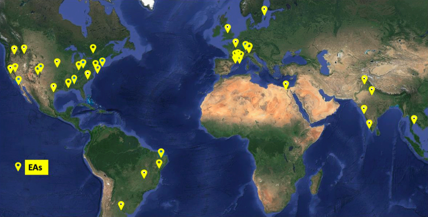
The 2023 SWOT Applications Workshop offered an opportunity to assess how the SWOT user community is using the data in anticipation of future SWOT data reprocessing and releases. The 2023 meeting explored three themes: 1) planned and current operational and applied uses of SWOT data; 2) the current state of the data products and access to the data; and 3) a variety of other projects that may/will include SWOT data in their applications.
The first public release of SWOT data came in June 2023, with the release of nadir altimeter and radiometer data. These data had a head-start in processing due to the instrument and processing heritage. These early releases allowed the EA community to begin incorporating SWOT into their operational models and systems. A public release of beta pre-validated SWOT KaRIn data products took place in November 2023, and the subsequent public release of pre-validated SWOT KaRIn data products in February 2024. SWOT KaRIn, nadir altimeter, and radiometer products are now in operational production and routinely available.
Workshop Overview
This workshop focused on the achievements of the SWOT EAs, offering a platform to share their projects with the community as they transition from “early adoption” to simply “adoption” of SWOT as a valuable resource in their system management toolbox. In addition, the meeting provided a space for discussions, an increased community awareness of the gaps and challenges of incorporating SWOT data into operational and decision-support framework for models, modeling systems, and other operational uses. Feedback from these discussions – especially concerning the known limitations of SWOT data with respect to data latency and mission length – will be exceptionally useful to the SWOT Project and Applications Teams.
Meeting Welcome and “Keynote” Presentations
Brad Doorn [NASA Headquarters (HQ)—Programmatic Lead], Annick Sylvestre-Baron [CNES—Programmatic Lead], Parag Vaze [JPL—SWOT Project Manager], and Pierre Sengenes [CNES—Project Lead] gave remarks to open the meeting. They welcomed attendees on behalf of NASA and CNES.
The first morning session closed with two highly relevant and illuminating presentations. Jinbo Wang [JPL] spoke about SWOT KaRIn performance and calibration/validation (Cal/Val) activities. Curtis Chen [JPL] detailed critical and important proclivities of KaRIn data products that EAs may find beneficial as they interpret data results. Understanding the information in Chen’s talk is critical for those planning to use the data.
SWOT Early Adopter Project Updates
The EA project summaries selected for this article provide an overview of the range and depth of the extensive work accomplished by the SWOT EA community to date. These examples illustrate the potential of SWOT data as a tool to manage surface water resources and forecast ocean and coastal conditions via operational systems in the coming years.
Daniel Moreira [Brazil Geological Society (BGS)—Project Investigator] explained that the current gauge network on rivers across the Amazon basin is limited. SWOT data offers unprecedented spatial and temporal coverage of water storage processes and may be beneficial to prepare for floods and extreme events in the basin. Moreira’s group has compared several sites using Global Navigation Satellite System data and a gauge station elevation time series with very good results. In addition, BGS maintains a weekly water level report and a web application that leverages satellite altimetry data from the S6MF and Jason-3 missions for comparison across the Amazon Basin. BGS plans to produce discharge datasets over the Amazon using altimetry.
Isabel Houghton [Sofar Ocean] introduced the Sofar Ocean ship route optimization and navigational safety platform, incorporating 10-day, data-assimilating marine weather forecasts. That data includes significant wave height estimates from both the Sofar spotter buoy network and estimates derived from nadir altimeters on NASA’s S6MF and Jason-3 missions and the joint CNES–Indian Space Research Agency (ISRO) Satellite with ARgos and ALtiKa (SARAL) satellites. (Argos collects data from a floating oceanic buoy network with the same name that CNES operates; AltiKa is a CNES-contributed Ka-band altimeter.) TheWaveWatch III model improves on the forecast through the addition of altimeter data. Houghton explained that Sofar Ocean is in the preliminary stages of using SWOT significant wave height data in their model, which is less noisy than the predecessor altimeters reducing forecast error. Sofar expects SWOT to improve their observation numbers by 50–100% in a given 24-hour period. Additionally, Sofar plan to use KaRIn observations in an Earth system model under development to address waves, circulation, and atmosphere.
Robert Dudley [U.S. Geological Survey (USGS)] presented a project that involved the team integrating data from SWOT and in situ sources together to derive discharge and flow velocity for the Tanana and Yukon Rivers in Alaska. The USGS is collaborating with the Physical Oceanography Distributed Active Archive (PO.DAAC) to integrate SWOT in SatRSQ measurements to develop the Water Information from Space (WISP) dashboard to access time series of SWOT hydrology products. WISP is in development and not yet publicly available. When operational, it will enable comparisons with collocated, ground-gauged time series. WISP contains SWOT orbital ground tracks and will add the SWOT lake database in the future. The dashboard should be publicly available later in 2024.
Gregg Jacobs [U.S. Naval Research Laboratory (NRL)] explained how NRL has evaluated SWOT KaRIn SSH data accuracy and integrated it into ocean forecast models by characterizing along-track errors in early data products to determine the necessary corrections. Jacobs then explained how the team computed daily interpolation of nadir altimeter data at SWOT crossover locations. They found good agreement between the corrected SWOT estimates and interpolated SSH from nadir altimeters and conducted ocean forecast experiments on California SWOT crossover Cal/Val sites – see Figure 2. NRL has had success in assimilating KaRIn data at a resolution of 5 km (~3 mi).
Figure 2. Altimetry data collected over calibration/validation (Cal/Val) sites using traditional nadir altimeter data only [left], a combination of traditional nadir altimeter data and in situ observations [center], and a combination of traditional altimeter data and SWOT altimeter data. The dotted lines indicate the satellite ground track paths. Figure credit: U.S. Naval Research Laboratory
Pierre Yves Le Traon [Mercator Ocean International (MOi)] explained that MOi is a non-profit that is now transforming into an intergovernmental organization. He began with a description of the Copernicus Marine Service, which is a long-term partnership between CNES, MOi, and a French company called Collecte Localisation Satellites (CLS) that focuses on ocean monitoring and forecasting. SWOT data will be used to constrain small scales in models – see Figure 3. The preliminary results are in good agreement with CNES Level-3 (L3) products. SWOT KaRIn data will be integrated into the operational Copernicus Marine Service operational forecast portfolio in 2025.
Figure 3. Both these maps show the root mean square (RMS) error in the SWOT 21-day phase data in sea level anomaly (SLA) over one month on the 1/12° Mercator Ocean global forecasting system The image pair contrasts the SLA RMS error without including SWOT data in the assimilation [left] versus when SWOT data are included in the assimilation [right]. Note that including SWOT data make smaller scale errors in the data become more apparent. Figure credit: Mercator Ocean International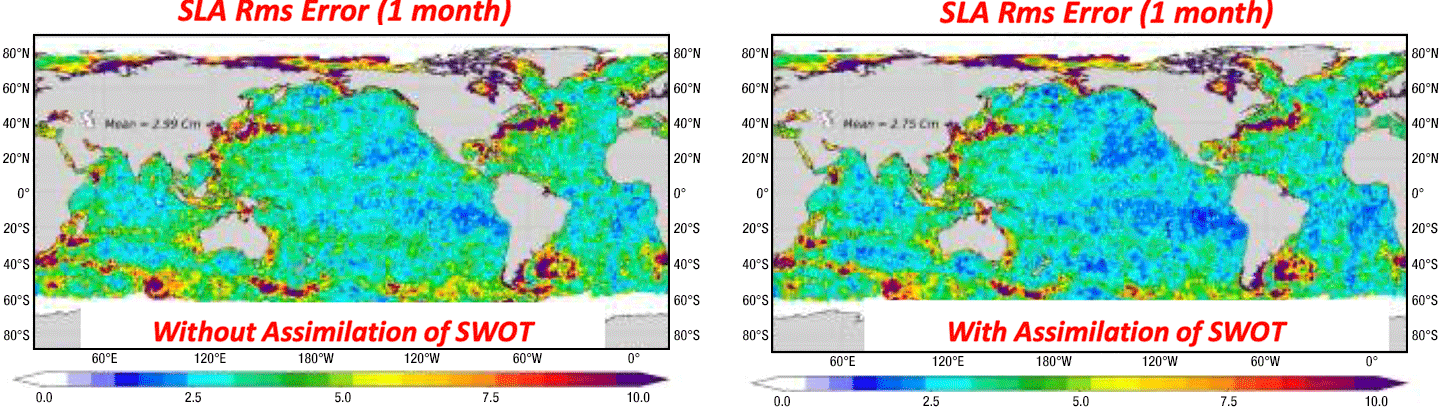
Guy Schumann [Water in Sight]explained this Swedish start-up company uses SWOT data to validate in situ gauge data in Malawi. Gauge readers and observers collect data at monitoring stations from south to north Malawi to support the government’s efforts in managing water and climate risks. They have used free Short Message Service and leveraged citizen science to develop a cloud platform for data access. For the next step, the project plans to integrate SWOT data into two-dimensional (2D) flood models. This EA project aims to address latency – time delay between collection and transmission of data – and interoperability challenges, enhancing hydrological network optimization as well as demonstrating the diverse complementary value of satellite observations. The group supports codesigned joint explorations, engagement activities, and technology alignment. The CNES hydroweb tool may be very useful in this endeavor, but Schumann acknowledges that there are interoperability challenges that need to be overcome.
Jerry Wegiel [NASA’s Goddard Space Flight Center] explained that the U.S. Air Force’s Weather Land Information System (LIS) is a software framework used by multiple agencies for simulating land/hydrology processes. The Global Hydrology Intelligence (GHI) system (rebranding of LIS) is a comprehensive framework for hydrologic analysis, forecasting, and projections across scales encompassing all aspects of water security and addressing significant hydro-intelligence gaps identified by the defense and national security communities. Integration of SWOT L2 products operationally into the LIS Hydrological Modeling and Analysis Platform (HyMAP) model is expected to improve the global hydrological model data analysis system, as well as improve extreme hydrological event monitoring, reduce forecasting uncertainty, and support water security conflicts.
Alexandre de Amorim Teixeira and Alexandre Abdalla Araujo [both at Agência Nacional de Águas e Saneamento Básico (ANA), or Brazilian National Water and Sanitation Agency] began by explaining that the ANA hydrography datasets [e.g., Base Hidrográfica Ottocodificada (BHO)] and water atlases [e.g., Base Hidrográfica Atlas-Estudos (BHAE)] have been extended using information from the SWOT River Database (SWORD) river reaches, which are roughly 10 km (~6 mi) SWORD-specified sections of a river, in Brazil – see Figure 4. By incorporating SWORD data into the BHAE, over 400,000 reaches have been identified – compared to 20,000 identified previously using SWORD alone. The latest version (6.2) of BHO will combine SWORD and BHAE data increasing numbers exponentially to nearly 5.5 million. The ANA EA project will use SWOT data to support water resource management in Brazil. ANA is working in collaboration with University Brasilia to integrate available gauge information on rivers and reservoirs to fulfill their mandate to determine and report on water availability in the country. They described a sophisticated hexagonal hierarchical geospatial indexing system that will support hydrological and hydrodynamical modeling and cross-validation. The team will use SWOT data pixel cloud or raster products to best serve their needs.
Figure 4. The Agência Nacional de Águas e Saneamento Básico’s (ANA) [Brazilian National Water and Sanitation Agency] SWOT Early Adopter project is extending hydrography datasets, e.g., Base Hidrográfica Ottocodificada (BHO) [top] and water atlases, e.g., Base Hidrográfica Atlas-Estudos (BHAE) [middle] using the SWOT data to produce the SWOT River Database (SWORD) product [bottom] that expands on the extent of the BHO hydrography dataset. Image credit: ANA
Data Systems and Products for Early Adopters
In 2021, the SWOT Project Science Team made simulated datasets available for select hydrologic and oceanographic regions. These datasets shared many characteristics in common with future SWOT data products (e.g., formats, metadata, and data contents) and were intended to familiarize users with the expected SWOT science data products.
At this meeting, teams from both the NASA and CNES mission data system and data repositories shared timely and valuable information and updates with the EA community. The talks provided information and insight into what users can expect from SWOT products.
Lionel Zawadzki and Cyril Germineaud [both at CNES] described the use of SWOT data available from CNES through the AVISO (ocean and coastal) and hydroweb.next (hydrology and ocean) data portals. Systems supporting data access include data acquisition and production, data repositories, and ultimately cloud data access through thematic portals.
Catalina Taglialatela and Cassandra Nickles [both at JPL] discussed the use of KaRIn high-resolution and low-resolution SWOT data products available through PO.DAAC, which provides centralized, searchable access that is available using an in-cloud commercial web service through the NASA EarthData portal. The team demonstrated resources and tutorials available via the online PO.DAAC Cookbook: SWOT Chapter, as well as the new Hydrocron SWOT time series applications programming interface (API) for generating time series over water features identified in SWORD and SWODLR, which is a system for creating on-demand L2 SWOT raster products.
Shailen Desai [JPL] explained how KaRIn products depend on upstream orbit, attitude, and radiometer products for optimal accuracy. SWOT KaRIn, nadir altimeter, and radiometer products are now in operational production and routinely available. Product description documents and SWOT algorithm theoretical basis documents are all publicly available.
Curtis Chen [JPL] discussed how the SWOT science data system team have reduced complexities of the KaRIn measurements to ensure robust interpretation of the results. Knowledge of measurement details may be especially important in trying to interpret the pre-validated data products. During his presentation, Chen addressed practical aspects of interpreting KaRIn data products, including answers to frequently asked questions and tips to avoid confusion and misinterpretation in using the data.
Yannice Faugere [CNES] explained how CNES will assimilate SWOT data into Mercator Ocean with value-added elements, including multimission calibration, noise mitigation, and images that blend KaRIn and nadir instruments. A preliminary assessment of L4 products was conducted using one-day Cal/Val orbit measurements with promising results. Tests on 21-day data and an L4 data challenge for community feedback to compare mapping and validation methods are in process.
Complementary Projects
Participants spoke about a number of other projects and programs during the meeting. The selected presentations address elements relevant to SWOT applications.
Charon Birkett [NASA] discussed how SWOT data will be incorporated into the Global REservoir and LAke Monitor (G-REALM) and Global Water Measurements (GWM) portal, to integrate nadir radiometer and KaRIn measurements. G-REALM maintains a 30-plus-year time series of nadir altimeter data from the NASA/CNES reference missions for this measurement (i.e., Topex/Poseidon; Jason -1, -2, and -3; and S6MF) as well as the European Remote Sensing Satellite. GWM is focused on lakes and reservoirs, rivers, and wetland water levels to derive surface extents and storage change.
Stephanie Granger [JPL] introduced the Western Water Applications Office (WWAO), which provides NASA data, technology, and tools for water management to water managers in the western U.S. The WWAO team completes needs assessments for basins – a task complicated by the more than 100 agencies involved in water management activities in the western U.S. Granger identified several activities that could benefit from SWOT data, such as extreme event predictions and impacts, timely streamflow predictions at a sub-basin level, wet/dry indicators from streamflow monitoring, and flood plain mapping.
Babette Tchonang, Dimitris Menemenlis,and Matt Archer [all from JPL] presented a study that evaluates the feasibility of applying the Estimating the Circulation and Climate of the Ocean 4-Dimensional Variational (MITgcm-ECCO 4DVAR) data assimilation framework to a sub-mesoscale resolving model [grid resolution of 1 km (~0.6 mi)] in preparation for future studies to assimilate SSH measurements from SWOT. Two model solutions are nested within the global 1/12° Hybrid Coordinate Ocean Model (HYCOM)/Navy Coupled Ocean Data Assimilation (NCODA) analysis. Comparing the two model solutions against assimilated and withheld in situ observations indicates that the MITgcm-ECCO 4DVAR framework can be applied to the reconstruction of sub-mesoscale ocean variability. This data assimilation system is now being used by the Scripps Institution of Oceanography to support SWOT post-launch activities.
Matt Bonnema [JPL] presented the Observational Products for End-Users from Remote Sensing Analysis (OPERA) project, which produces a suite of surface water extent products, such as Dynamic Surface Water extent (DSWx). The products are based on a variety of optical and radar sensors built on existing satellite data that are freely available from NASA. DSWx gives two dimensions of surface water measurements (i.e., spatial extent), whereas SWOT produces three dimensions of surface water measurement (i.e., spatial extent and elevation). DSWx has the potential to fill in temporal gaps in SWOT observations and to cross-compare DSWx and SWOT when observations are concurrent. DSWx is a valuable source of global water information that can be used to interpret and enhance SWOT’s capabilities.
Renato Frasson [JPL] explained how the U.S. Army Corps of Engineers support the National Geospatial-Intelligence Agency (NGA), which uses water storage and lake/reservoir flux information primarily from NASA’s MODerate resolution Imaging Spectroradiometer (MODIS) that flies on both the Terra and Aqua platforms. SWOT data has a higher spatial resolution for river widths, and NASA–ISRO Synthetic Aperture Radar (NISAR) observations are planned to be incorporated into the OPERA platform.
Cedric David [NASA/JPL] discussed how SWOT data can improve state-of-the-art hydrologic models to address environmental and societal challenges in river system science (e.g., flooding, water security, river biodiversity, changing deltas, and transboundary issues). Model advancements (e.g., U.S. National Water Model) can be realized in areas such as uncertainty quantification, data assimilation, bias correction, and decreasing numbers of in situ observation systems. Incorporating SWOT data into river models will lead to more realistic representations of these rivers, which in turn will improve the users’ ability to understand and effectively manage these critical and threatened water resources.
Workshop Recommendations and Feedback
This 2023 SWOT Applications Workshop provided an opportunity to share early experiences with SWOT data and insight into integration of the data into operational and decision-support workflows and models (e.g., ocean circulation and hydrologic, hydrodynamic, and decision support). Understanding how EAs integrate SWOT data and the associated challenges is critical to provide a clear analytical path for assessing the value of SWOT’s observations.
Integrating satellite observations into models enhances the model’s capability to forecast natural phenomena and monitor remote or inaccessible regions, expanding modeling capabilities dynamically and spatially. The EA-user community shared information on the potential of incorporating SWOT data into local- or community-wide models or modeling systems. SWOT’s high-resolution data – particularly from the KaRIn instrument – can enhance the precision of hydrology and ocean models by enabling detailed simulations of water dynamics. This includes accurate mapping of freshwater bodies and SSH. Both these measurements are crucial for managing water resources, predicting floods, and understanding ocean circulation patterns. The incorporation of SWOT data into model systems enables significant advancement and insights that can inform environmental management policies and practices by supporting more informed decision-making.
Although the SWOT nadir altimeter data products are being operationally produced and distributed through the data centers, the new data products from the novel KaRIn instrument continue to be assessed. An entire year of data is necessary for a more comprehensive assessment of value, ease of use, and degree to which SWOT data will impact operations and decision-making.
Throughout the workshop, EAs shared their experiences and specific needs in regard to early use of SWOT data in their modeling frameworks. Overall impressions were positive, but the actual use of SWOT beta product data was limited to a few projects (e.g., NRL, Sofar Ocean, and Copernicus Marine Service). Overall, the meeting participants supported the need for lower-latency products.
In the coming year, the impact of SWOT data with lower 21-day science orbital repeat frequency and latency on various applications will be understood further. Ultimately, the most important feedback from SWOT EAs is yet to come.
SWOT has the potential to provide invaluable information to operational user communities through its ability to advance understanding of global surface water dynamics. The SWOT Applications Program has successfully engaged a diverse cohort of agencies and the commercial sector to support integrating SWOT data into operational workflows. Moving forward, the program aims to highlight societal benefits, support applied research in hydrology and oceanography, expand user engagement, and provide ongoing training to maximize the effective use of fully validated SWOT data products.
Conclusion
The 2023 SWOT Applications meeting was a successful and timely engagement opportunity, further strengthening the connection between the different collaborating organizations. Many EAs demonstrated early ingest of the preliminary release of KaRIn data, with some having already started using the nadir altimeter data in their operational processes. Engagement will continue as more data, including pre-validated and validated science products, become regularly available with support to the EA community.
Future SWOT Application activities will include continued communication at community meetings and conferences as well as with a broader audience to engage new users for both applied research and operational activities through workshops, hackathons, and telecons. The SAWG will continue working with EAs and the applied and operational user communities to identify and apply value of SWOT to support decision makers and operational agencies.
NASA and CNES data distribution centers will continue to train users in cloud data access, data formats, and preferred formats for different topics, as well as provide EA feedback to improve data products and platform services. NASA and CNES will continue to work with EAs to overcome technical hurdles, help complete their projects, and generate high-impact success stories, as well as expand the extent of SWOT EAs and applied science users to build recognition of SWOT among practitioners.
Acknowledgment: The author wishes to acknowledge the contribution of Stacy Kish [NASA’s Goddard Space Flight Center (GSFC)/Global Science and Technology, Inc. (GST)] for her editing work to reduce/repurpose the full summary report to create a version suitable for the context of The Earth Observer.
Margaret Srinivasan
NASA/Jet Propulsion Laboratory, California Institute of Technology
margaret.srinivasan@jpl.nasa.gov
Hurricane Helene’s Devastation Shows No Region Is Safe from Climate-Fueled Disaster
Hurricane Helene fueled catastrophic flooding from Florida to Appalachia, leaving millions without power
30 Years Ago: STS-68 The Second Space Radar Lab Mission
On Sept. 30, 1994, space shuttle Endeavour took to the skies on its 7th trip into space. During the 11-day mission, the STS-68 crew of Commander Michael A. Baker, Pilot Terrence “Terry” W. Wilcutt, and Mission Specialists Steven L. Smith, Daniel W. Bursch, Peter J.K. “Jeff” Wisoff, and Payload Commander Thomas “Tom” D. Jones operated the second Space Radar Laboratory (SRL-2) as part of NASA’s Mission to Planet Earth. Flying five months after SRL-1, results from the two missions provided unprecedented insight into Earth’s global environment across contrasting seasons. The astronauts observed pre-selected sites around the world as well as a volcano that erupted during their mission using SRL-2’s U.S., German, and Italian radar instruments and handheld cameras.
Left: The STS-68 crew patch. Right: Official photo of the STS-68 crew of Thomas D. Jones, front row left, Peter J.K. “Jeff” Wisoff, Steven L. Smith, and Daniel W. Bursch; Michael A. Baker, back row left, and Terrence W. Wilcutt.
In August 1993, NASA named Jones as the SRL-2 payload commander, eight months before he flew as a mission specialist on STS-59, the SRL-1 mission. When NASA could not meet JPL’s request to fly their personnel as payload specialists on the SRL missions, the compromise solution reached had one NASA astronaut – in this case, Jones – fly on both missions. Selected as an astronaut in 1990, STS-59 marked Jones’ first flight and STS-68 his second. In October 1993, NASA named the rest of the STS-68 crew. For Baker, selected in 1985, SRL-2 marked his third trip into space, having flown on STS-43 and STS-52. Along with Jones, Wilcutt, Bursch, and Wisoff all came from the class of 1990, nicknamed The Hairballs. STS-68 marked Wilcutt’s first spaceflight, while Bursch had flown once before on STS-51 and Wisoff on STS-57. Smith has the distinction as the first from his class of 1992 – The Hogs – assigned to a spaceflight, but the Aug. 18 launch abort robbed him of the distinction of the first to actually fly, the honor going instead to Jerry M. Linenger when STS-64 ended up flying before STS-68.
Left: The Spaceborne Imaging Radar-C (SIR-C) in Endeavour’s payload bay in the Orbiter Processing Facility at NASA’s Kennedy Space Center in Florida. Middle: Endeavour on Launch Pad 39A. Right: STS-68 crew in the Astrovan on its way to Launch Pad 39A for the Terminal Countdown Demonstration Test.
The SRL payloads consisted of three major components – the Spaceborne Imaging Radar-C (SIR-C), built by NASA’s Jet Propulsion Laboratory in Pasadena, California, the X-band Synthetic Aperture Radar (X-SAR) sponsored by the German Space Agency DLR and the Italian Space Agency ASI, and the Measurement of Air Pollution from Satellites (MAPS), built by NASA’s Langley Research Center in Hampton, Virginia. Scientists from 13 countries participated in the SRL data gathering program, providing ground truth at preselected observation sites. The SIR system first flew as SIR-A on STS-2 in November 1981, although the shortened mission limited data gathering. It flew again as SIR-B on STS-41G in October 1984, and gathering much useful data.
Building on that success, NASA planned to fly an SRL mission on STS-72A, launching in March 1987 into a near-polar orbit from Vandenberg Air Force, now Space Force, Base in California, but the Challenger accident canceled those plans. With polar orbits no longer attainable, a 57-degree inclination remained the highest achievable from NASA’s Kennedy Space Center (KSC) in Florida, still allowing the radar to study more than 75% of Earth’s landmasses. As originally envisioned, SRL-2 would fly about six months after the first mission, allowing data gathering during contrasting seasons. Shuttle schedules moved the date of the second mission up to August 1994, only four months after the first. But events intervened to partially mitigate that disruption.
Left: Launch abort at Launch Pad 39A at NASA’s Kennedy Space Center in Florida. Right: A few days after the launch abort, space shuttle Discovery arrives at Launch Pad 39B, left, with space shuttle Endeavour still on Launch Pad 39A, awaiting its rollback to the Vehicle Assembly Building.
Endeavour arrived back at KSC following its previous flight, the STS-59 SRL-1 mission, in May 1994. Workers in KSC’s Orbiter Processing Facility refurbished the SRL-1 payloads for their reflight and serviced the orbiter, rolling it over to the Vehicle Assembly Building (VAB) on July 21 for mating with its External Tank and Solid Rocket Boosters (SRBs). Endeavour rolled out to Launch Pad 39A on July 27. The six-person STS-68 crew traveled to KSC to participate in the Terminal Countdown Demonstration Test on Aug. 1, essentially a dress rehearsal for the launch countdown. They returned to KSC on Aug. 15, the same day the final countdown began.
Following a smooth countdown leading to a planned 5:54 a.m. EDT launch on Aug. 18, Endeavour’s three main engines came to life 6.6 seconds before liftoff. With just 1.8 seconds until the two SRBs ignited to lift the shuttle stack off the pad, the Redundant Set Launch Sequencer (RSLS) stopped the countdown and shutdown the three main engines, two of which continued running past the T-zero mark. It marked the fifth and final launch abort of the shuttle program, and the closest one to liftoff. Bursch now had the distinction as the only person to have experienced two RSLS launch aborts, his first one occurring on STS-51 just a year earlier. Engineers traced the shutdown to higher than anticipated temperatures in a high-pressure oxygen turbopump in engine number three. The abort necessitated a rollback of Endeavour to the VAB on Aug. 24 to replace all three main engines with three engines from Atlantis on its upcoming STS-66 mission. Engineers shipped the suspect engine to NASA’s Stennis Space Center in Mississippi for extensive testing, where it worked fine and flew on STS-70 in July 1995. Meanwhile, Endeavour returned to Launch Pad 39A on Sept. 13.
Liftoff of Endeavour on the STS-68 mission.
On Sept. 30, 1994, Endeavour lifted off on time at 6:16 a.m. EDT, and eight and half minutes later delivered its crew and payloads to space. Thirty minutes later, a firing of the shuttle’s Orbiter Maneuvering System (OMS) engines placed them in a 132-mile orbit inclined 57 degrees to the equator. The astronauts opened the payload bay doors, deploying the shuttle’s radiators, and removed their bulky launch and entry suits, stowing them for the remainder of the flight.
Left: The Space Radar Laboratory-2 payload in Endeavour’s cargo bay, showing SIR-C (with the JPL logo on it), X-SAR (the long bar atop SIR-C), and MAPS (with the LaRC logo on it). Middle: The STS-68 Blue Team of Daniel W. Bursch, top, Steven L. Smith, and Thomas D. Jones in their sleep bunks. Right: Tile damage on Endeavour’s starboard Orbital Maneuvering System pod caused by a strike from a tile from Endeavour’s front window rim that came loose during the ascent.
Left: Steven L. Smith, left, and Peter J.K. “Jeff” Wisoff set up the bicycle ergometer in the shuttle’s middeck. Middle: The STS-68 Red Team of Terrence W. Wilcutt, top, Wisoff, and Michael A. Baker in their sleep bunks. Right: Wilcutt consults the flight plan for the next maneuver.
The astronauts began to convert their vehicle into a science platform, and that included breaking up into two teams to enable 24-hour-a-day operations. Baker, Wilcutt, and Wisoff made up the Red Team while Smith, Bursch, and Jones made up the Blue Team. Within five hours of liftoff, the Blue Team began their sleep period while the Red Team started their first on orbit shift by activating the SIR-C and X-SAR instruments in the payload bay and some of the middeck experiments. During inspection of the OMS pods, the astronauts noted an area of damaged tile, later attributed to an impact from a tile from the rim of Endeavour’s front window that came loose during the ascent to orbit. Engineers on the ground assessed the damage and deemed it of no concern for the shuttle’s entry.
Left: Michael A. Baker prepares to take photographs through the commander’s window. Middle: Thomas D. Jones, left, Daniel W. Bursch, and Baker hold various cameras in Endeavour’s flight deck. Right: Terrence W. Wilcutt with four cameras.
Left: Thomas D. Jones, left, and Daniel W. Bursch consult a map in an atlas developed specifically for the SRL-2 mission. Middle: Jones takes photographs through the overhead window. Right: Steven L. Smith takes photographs through the overhead window.
By sheer coincidence, the Klyuchevskaya volcano on Russia’s Kamchatka Peninsula began erupting on the day STS-68 launched. By the mission’s second day, the astronauts trained not only their cameras on the plume of ash reaching 50,000 feet high and streaming out over the Pacific Ocean but also the radar instruments. This provided unprecedented information of this amazing geologic event to scientists who could also compare these images with those collected during SRL-1 five months earlier.
Left: Eruption of Klyuchevskaya volcano on Russia’s Kamchatka Peninsula. Middle: Radar image of Klyuchevskaya volcano. Right: Comparison of radar images of Mt. Pinatubo in The Philippines taken during SRL-1 in April 1994 and SRL-2 in October 1994.
The STS-68 crew continued their Earth observations for the remainder of the 11-day flight, having received a one-day extension from Mission Control. On the mission’s eighth day, they lowered Endeavour’s orbit to 124 miles to begin a series of interferometry studies that called for extremely precise orbital maneuvering to within 30 feet of the orbits flown during SRL-1, the most precise in shuttle history to that time. These near-perfectly repeating orbits allowed the construction of three-dimensional contour images of selected sites. The astronauts repaired a failed payload high rate recorder and continued working on middeck and biomedical experiments.
Left: Steven L. Smith, left, conducts a biomedical experiment as Michael A. Baker monitors. Right: Peter J.K. “Jeff” Wisoff, left, and Smith repair a payload high rate recorder.
A selection of STS-68 crew Earth observation photographs. Left: The San Francisco Bay area. Middle left: The Niagara Falls and Buffalo area. Middle right: Riyadh, Saudi Arabia. Right: Another view of the Klyuchevskaya volcano on Russia’s Kamchatka Peninsula.
The high inclination orbit afforded the astronauts great views of the aurora australis, or southern lights.
On this mission in particular, the STS-68 astronauts spent considerable time looking out the window, their images complementing the data taken by the radar instruments. Their high inclination orbit enabled views of parts of the planet not seen during typical shuttle missions, including spectacular views of the southern lights, or aurora australis.
Two versions of the inflight STS-68 crew photo.
On flight day 11, with most of the onboard film exposed and consumables running low, the astronauts prepared for their return to Earth the following day. Baker and Wilcutt tested Endeavour’s reaction control system thrusters and aerodynamic surfaces in preparation for deorbit and descent through the atmosphere, while the rest of the crew busied themselves with shutting down experiments and stowing away unneeded equipment.
Left: Endeavour moments before touchdown at California’s Edwards Air Force Base. Middle: Michael A. Baker brings Endeavour home to close out STS-68 and a successful SRL-2 mission. Right: Baker gets a congratulatory tap on the shoulder from Terrence W. Wilcutt following wheels stop.
Left: As workers process Endeavour on the runway, Columbia atop a Shuttle Carrier Aircraft (SCA) flies overhead on its way to the Palmdale facility for refurbishment. Right: Mounted atop an SCA, Endeavour departs Edwards for the cross-country trip to NASA’s Kennedy Space Center in Florida.
On Oct. 11, the astronauts closed Endeavour’s payload bay doors, donned their launch and entry suits, and strapped themselves into their seats for entry and landing. Thick cloud cover at the KSC primary landing site forced first a two-orbit delay in their landing, then an eventual diversion to Edwards Air Force Base (AFB) in California. The crew fired Endeavour’s OMS engines to drop out of orbit. Baker piloted Endeavour to a smooth landing at Edwards, ending the 11-day 5-hour 46-minute flight. The crew had orbited the Earth 182 times. Workers at Edwards safed the vehicle and placed it atop a Shuttle Carrier Aircraft for the ferry flight back to KSC. The duo left Edwards on Oct. 19, and after stops at Biggs Army Airfield in El Paso, Texas, Dyess AFB in Abilene, Texas, and Eglin AFB in the Florida panhandle, arrived at KSC the next day. Workers there began preparing Endeavour for its next flight, STS-67, in March 1995. Meanwhile, a Gulfstream jet flew the astronauts back to Ellington Field in Houston for reunions with their families.
Diane Evans, SIR-C project scientist, summarized the scientific return from STS-68, “We’ve had a phenomenally successful mission.” The radar instrument collected 60 terabits of data, filling 67 miles of magnetic tape during the mission. In 1990s technology, that equated to a pile of floppy disks 15 miles high! In 2006, using an updated comparison, astronaut Jones equated that to a stack of CDs 65 feet high. The radar instruments completed 910 data takes of 572 targets during about 80 hours of imaging. To complement the radar data, the astronauts took nearly 14,000 photographs using 14 different cameras. To image the various targets required more than 400 maneuvers of the shuttle, requiring 22,000 keystrokes in the orbiter’s computer. The use of interferometry, requiring precision orbital tracking of the shuttle, to create three-dimensional topographic maps, marks another significant accomplishment of the mission. Scientists published more than 5,000 papers using data from the SRL missions.
Enjoy the crew narrate a video about the STS-68 mission. Read Wilcutt’s recollections of the mission in his oral history with the JSC History Office.
Explore More 15 min read 55 Years Ago: Celebrations for Apollo 11 Continue as Apollo 12 Prepares to Revisit the Moon Article 2 weeks ago 8 min read 65 Years Ago: First Powered Flight of the X-15 Hypersonic Rocket Plane Article 2 weeks ago 8 min read 55 Years Ago: Space Task Group Proposes Post-Apollo Plan to President Nixon Article 2 weeks agoNASA's Chandra X-ray telescope sees streams of gas cross in distant galaxy cluster (image)
An October Annular Solar Eclipse Rounds Out 2024
A remote annular solar eclipse bookends the final eclipse season for 2024.
The final eclipse of the year is almost upon us. If skies are clear, a few lucky observers and intrepid eclipse-chasers will get to witness the passage of the Moon in front of the Sun one last time on Wednesday, October 2nd during an annular solar eclipse.
The eclipse is the final one of the current season, and the last solar eclipse for 2024. The first—the April 8th total solar eclipse spanning North America—was witnessed by millions. This week’s eclipse is by contrast much more bashful.
The path and timing for Wednesday’s annular solar eclipse. Credit: from Michael Zeiler’s Atlas of Solar Eclipses (2020 to 2045). Why Do Annulars Occur?An annular solar eclipse occurs when the Moon is visually too small to cover the Sun. Both vary in apparent size throughout the month and year, as the orbits of the Moon and the Earth are both elliptical. The shadow of the Moon falls short of the surface of the Earth during an annular eclipse, and the ‘ring of fire’ path is known as an antumbra.
Stages of the 2019 annular eclipse as seen from Guam. Credit: Eliot HermanWe often marvel at how ‘perfect’ total solar eclipses are, but this situation slowly changing. Going forward, annulars are already more common, as the Moon slowly moves away from the Earth… in about 600 million years annulars will win this battle for good, as total solar eclipses will cease to occur on the surface of the Earth.
The path for Wednesday’s annular solar eclipse over the southern tip of South America. Credit: from Michael Zeiler’s Atlas of Solar Eclipses (2020 to 2045).There’s good reason why this eclipse is annular. The Moon reaches its most distant apogee of 2024 on October 2nd at 50 minutes after eclipse conjunction at 19:08 Universal Time, at 406,516 kilometers from Earth.
Eclipse Path and CircumstancesThe path crosses the South Pacific, and only makes landfall across Easter Island, Chile, Argentina. Maximum annularity reaches 7 minutes and 25 seconds in duration northwest of Easter Island. There’s a chance for some excellent ‘horns of the Sun’ shots towards sunset around to Falkland Islands and the Horn of South America.
An animation of Wednesday’s eclipse. Credit: NASA/GSFC/A.T. SinclairThe partial phases of the eclipse will be visible from Antarctica and northern New Zealand, across southern South America all the way up to Brazil, Paraguay and Peru, up to a small sliver of the west Pacific coast of Mexico. The Falkland Islands in the Atlantic ocean will see a narrow miss, with Stanley seeing an 84% obscured partial eclipse.
This eclipse also marks the end of the second and final eclipse season for 2024. This season was book-ended by the slight partial lunar eclipse earlier this month.
This eclipse is also member 17 in the 70 eclipses in relatively new Solar Saros Series 144. This saros is a prolific producer of annulars, and started on April 11th, 1736 and will end on May 5th 2980.
Viewing and SafetyUnlike a total solar eclipse, proper safety precautions must be taken during Wednesday’s eclipse… even during the annular phase. A few percent of the Sun is still pretty bright, enough to give the sky a deep blue-steely tint, the only hint that something might be afoot. NASA has a pretty solid eclipse safety page.
There’s another low tech way to observe the eclipse. Keep an eye out for tiny crescent suns cast though natural pin hole projectors. These can include gaps in tree leaves and latticework. Kitchen utensils such as graters and strainers will also do the trick.
Crescents cast through gaps in the tree leaves seen from Mapleton Maine during the June 2021 annular solar eclipse. Credit: Dave Dickinson.Comet T-ATLAS ‘may’ also make an appearance during the eclipse. Have any comets ever appeared during an annular? Certainly bright comets have made themselves known during the daytime. There’s now a chance that Comet Tsuchinshan-ATLAS ‘may’ reach negative magnitudes in early October, and the comet will be ~20 degrees from the Sun during next Wednesday’s annular eclipse… To be sure, it’s an extremely remote chance to see comet T-ATLAS against a bright sky, but I remember noticing Venus becoming plainly visible on April 8th about 10 minutes prior to totality, so you just never know…
The next eclipses in 2025 includes only two partial solars worldwide: one on March 29th for the North Atlantic, and another on September 21st for New Zealand and the South Pacific. The next annular won’t occur until February 17th, 2026 for the remote Antarctic.
Will the eclipse be carried live? As of writing this, no live streams along the path have emerged, but we’ll drop them here if any turn up.
Update: Time & Date ‘may’ carry the eclipse live (weather permitting) from Easter Island:
if you have the chance, don’t miss this final eclipse of the year.
The post An October Annular Solar Eclipse Rounds Out 2024 appeared first on Universe Today.
Hera asteroid mission
Hera asteroid mission
ESA's first planetary defence mission, headed to a binary asteroid
Supermassive black hole jets mysteriously ignite nova explosions, Hubble Telescope finds
ESA releases new strategy for Earth observation
ESA has released its new Earth Observation Science Strategy, Earth Science in Action for Tomorrow’s World. Responding to the escalating threats from climate change, biodiversity loss, pollution and extreme weather and the need to take action to address these threats, this forward-looking strategy outlines a bold vision for Earth science through to 2040.
Why space archaeologists are finding more Mayan ruins than ever before (exclusive)
Nuclear Detonations Could Deflect Dangerous Asteroids Away from Earth
Before you read the rest of this article know there are no known threats to life on Earth! We shouldn’t sit complacently on this tiny rock in space though so NASA have been working on ways to neutralise potential asteroid threats should they arise. The DART mission proved it was possible to alter the trajectory of an asteroid in space. Direct impact though where a probe smashes into the rock is one way but potentially not the best. A team of researchers have now been exploring ways that a nuclear explosion near an asteroid may send a blast of X-rays sufficiently powerful to vaporise material generating thrust to redirect the asteroid.
Statistically the risks of an asteroid are low but the ‘impact’ of such an event could be catastrophic. The majority of asteroids that enter our atmosphere burn up giving us the stunning sight of a ‘shooting star’ but those over 1km wide could cause widespread damage and devastation. The likelihood is rare and might occur once every several hundred thousand years but smaller objects hit more often. They can also create significant localised damage. Take the Chelyabinsk event in Russia in 2013 when an asteroid exploded in mid air sending shockwaves across hundreds of kilometres.
This image of a vapor trail was captured about 125 miles (200 kilometers) from the Chelyabinsk meteor event, about one minute after the house-sized asteroid entered Earth’s atmosphere. Credits: Alex AlishevskikhWhilst the risk is low we must put in place a plan to deal with such threats when they arise. The Double Asteroid Redirection Test mission that NASA launched back in 2021 sent a probe to the binary asteroid system Didymos with its tiny moon Dimorphos. The probe hit Dimorphos in September 2022 and very slightly altered the orbit proving it is possible to effect change in an asteroid trajectory. Whilst the approach worked, the scope of such an approach is limited since colliding a spacecraft may not be so effective on large asteroids. Coupled with the liklihood of not getting much notice and an alternative, more, effective approach is needed.
The asteroid Dimorphos was captured by NASA’s DART mission just two seconds before the spacecraft struck its surface on Sept. 26, 2022. Observations of the asteroid before and after impact suggest it is a loosely packed “rubble pile” object. Credit: NASA/JHUAPLOther approaches have been explored from deployment of fusion engines to the target rock, focussing laser beams on them, neutron bursts and of course nuclear blasts that generate X-ray radiation. Analysis of these options reveals that only the latter, nuclear blasts has been deemed as a suitable approach for the neutralisation of the threat of a large asteroid impact when only limited time is available.
A team of researchers led by Nathan W Moore has shown through simulations that a nuclear bomb could indeed deflect an incoming asteroid. Much of the energy release from a nuclear explosion is in the form of X-rays. the team showed that the X-ray emission would be sufficiently powerful to be able to vaporise the surface of an asteroid causing the results vapour to slowly propel the asteroid in the opposite direction. You can think of this as a very basic rocket engine with the vapour producing thrust. In simulations, the test asteroid reached speeds of 250 kilometres per hour!
The results showed for the first time that X-rays could work and may provide sufficient protection against an incoming asteroid up to 4 km wide assuming of course, we have sufficient notice! There in lies the challenge, asteroids are typically dark and finding them against the blackness of space can be a challenge. The more time we have, then the greater chance we have of deflection being a viable proposition.
The next step is for actual tests however, nuclear explosions come with high costs, high risks and a whole bunch of international legal restrictions. Careful planning is now needed with perhaps a little more research before this approach can be put on the shelf to be used should the need arise!
Source : Simulation of asteroid deflection with a megajoule-class X-ray pulse
The post Nuclear Detonations Could Deflect Dangerous Asteroids Away from Earth appeared first on Universe Today.
Combating Misinformation Runs Deeper Than Swatting Away ‘Fake News’
“Fake news”-style misinformation is only a fraction of what deceives voters. Fighting misinformation will require holding political elites and mainstream media accountable
China's enormous FAST radio telescope is getting even bigger (video)
How the U.N. Is Fighting Misinformation in Science
Here’s how misinformation and distrust in science are impacting global well-being. Plus, we present our regular roundup of this week’s science news.
Radioactive ion beam could target tumours more precisely
Radioactive ion beam could target tumours more precisely
The latest edition of ESA Impact is here
The latest edition of ESA Impact is here
Your interactive gateway to the most captivating stories and stunning visuals from ESA
Unloading Cargo on the Moon
I don’t think it’s something I have ever really thought of! Robotic explorers can travel around the Solar System visiting our neighbouring planets but when they arrive, sometimes a scientific package must be deployed to the surface. Never occurred to me just how that’s achieved! With a number of landers scheduled to visit the Moon, NASA are testing a new robotic arm called the Lightweight Surface Manipulation System AutoNomy capabilities Development for Surface Operations or LANDO for short! It will lift payloads off the lander and pop them down gently on the surface of the Moon.
The Moon has always held a special place in our hearts. Since the first humans saw it as they gazed up at the sky, their descendents continued the fascination with our nearest neighbour. Artists, musicians, poets and writers are among just a few of the members of our society that have reflected on its beauty. It was only natural that it would be the first target for human exploration at the dawn of space flight. The Apollo missions saw the first human visitors to the Moon and now we wait with bated breath as Artemis looks set to take us back again very soon.
Aldrin on the Moon. Astronaut Buzz Aldrin walks on the surface of the moon near the leg of the lunar module Eagle during the Apollo 11 mission. Mission commander Neil Armstrong took this photograph with a 70mm lunar surface camera. While astronauts Armstrong and Aldrin explored the Sea of Tranquility region of the moon, astronaut Michael Collins remained with the command and service modules in lunar orbit. Image Credit: NASAEven with human explorers it’s likely only to be a few at a time so mission planners are turning to robotic helpers for the more mundane work. A team of researchers at the Langley Research Centre in Virginia have been working upon a piece of robotic hardware with new software that can operate autonomously to move objects around on the surface! The team, led by Dr Julia Cline from NASA demonstrated the LANDO system and it performed perfectly.
Looking like a movie set, the team established the arena to look like the Moon, complete with boulders that Hollywood would be proud of. The team undertook their first demo by lifting a payload off a tall black pedestal and onto the floor. They then upped the challenge and tried the same manouver but with a small rover instead. Both tests were succesful.
Closeup of lunar surface (Credit NASA)Pivotal to the system is a series of sensors on the camera and encoders affixed to the side of the package. Once the system was ready the camera scanned the area looking for the payload which was outlined with the encoders (somewhat like a QR code.) Once it identified the item the robotic arm gently swung over the object and carefully manoeuvred its hook to snare the package. With a destination already defined using a graphical interface of the scene, the robotic arm moved around and dropped the placed the package just where the team commanded it too.
After a succesful delivery the hook slowly disengaged, returned to its home position and paused, ready for the next command. The testing nicely demonstrated the reliability of the system setting the scene for further more advanced tests. Now the team are looking to develop a larger more robust version that can be tested ahead of its first lunar mission.
The use of robotic arms like LANDO are of immense benefit, helping us to explore the Moon. Not only will they help with repetitive tasks but they can perform more precise scientific studies even in the relatively hostile environment of the lunar surface. Their high levels of dexterity and reliability mean they are an ideal tool for further development with lunar ready versions already being worked upon.
Source : Robotic Moving ‘Crew’ Preps for Work on Moon
The post Unloading Cargo on the Moon appeared first on Universe Today.
Sols 4318-4320: One Last Weekend in the Channel
- Curiosity Home
- Science
- News and Features
- Multimedia
- Mars Missions
- The Solar System
2 min read
Sols 4318-4320: One Last Weekend in the Channel This image from NASA’s Mars rover Curiosity shows the bright-toned rocks of the “Sheep Creek” target location, intriguing because of their resemblance to previous targets that contained unexpectedly high levels of elemental sulfur. The Left Navigation Camera aboard Curiosity captured this image on Sol 4316 — Martian day 4,316 of the Mars Science Laboratory mission — on Sept. 26, 2024, at 21:10:13 UTC. NASA/JPL-Caltech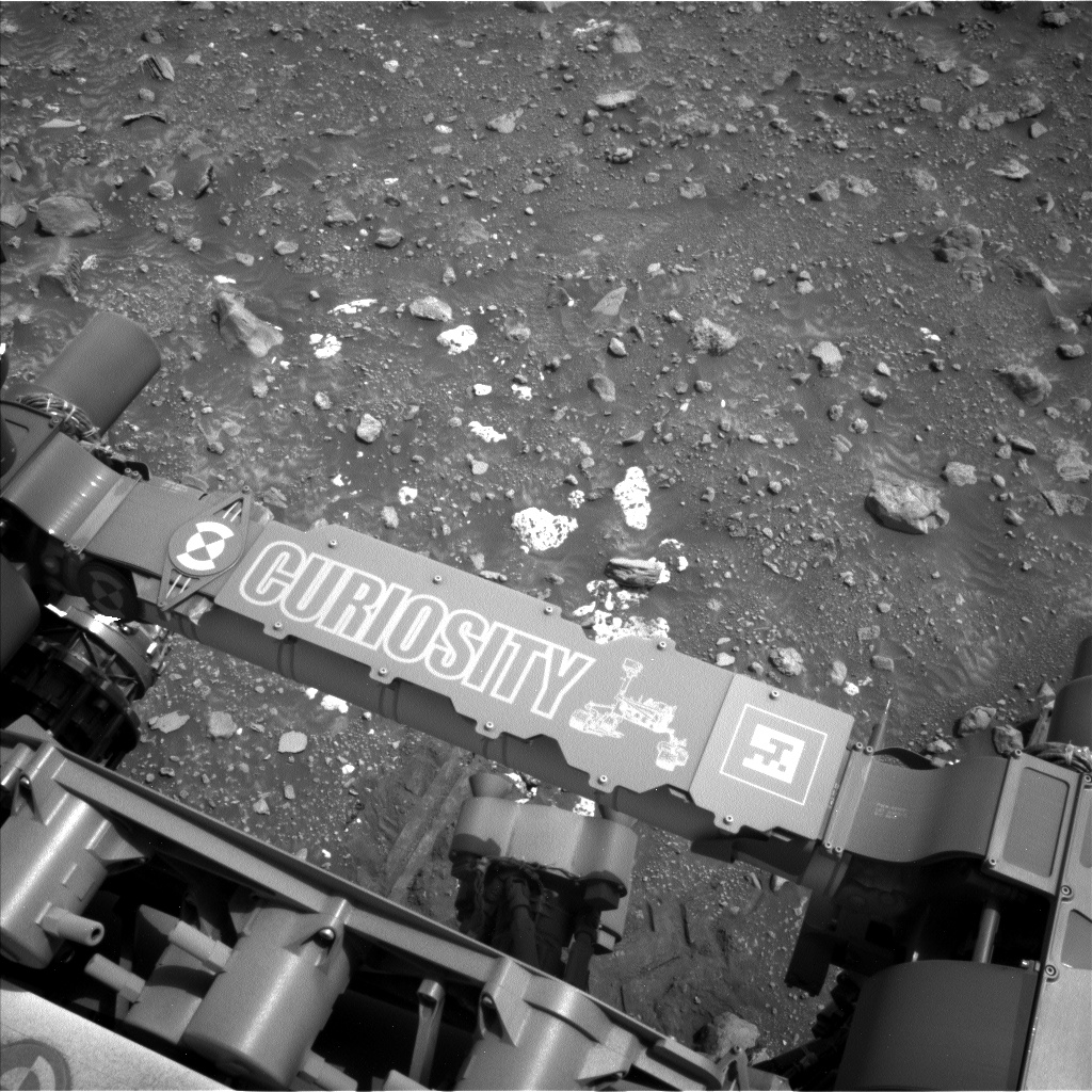
Earth planning date: Friday, Sept. 27, 2024
We’re wrapping up our time in the channel with the highly anticipated examination of the “Sheep Creek” white stones. Last plan’s reposition was a success, so we are able to go ahead with contact science on them this weekend. MAHLI and APXS picked three targets to investigate: “Cloud Canyon,” “Moonlight Lake,” and “Angora Mountain,” all of which sound so lovely and soft, and are quite evocative of these pale stones, which stand out so much against the background. ChemCam is also examining another of the white stones, “Pee Wee Lake.”
Since this is looking like it will be our last weekend in the channel, we’re packing the plan with all the other last-chance targets before we leave them behind. Mastcam is making a large survey of some other light-toned rocks in the middle distance dubbed “Orchid Lake,” as well as getting a bit more context for an old target, “Marble Falls,” which we first imaged almost two weeks ago. A bit closer to the rover, it will examine a target we’re calling “Brown Bear Pass,” to study the surface properties of the soil. Mastcam will also be looking backwards at our tracks to see if we turned up anything interesting in our travels. And ChemCam has a couple of long-distance observations of another familiar target, “Buckeye Ridge.”
After all that, it’s time for us to turn back around and head toward the edge of the channel with a drive of 55 meters (about 180 feet) back to our exit point. Even then, our weekend still isn’t over. We have a ChemCam-filled third sol, using AEGIS to autonomously select a target, and then getting a passive sky observation to keep an eye on the amount of different gases like oxygen and water vapor in the atmosphere. Speaking of the atmosphere, here on the environmental side we’re kept busy this weekend looking for dust devils and clouds, and keeping an eye on the amount of dust in the air around us. We’ll wrap up the weekend as we often do — with an early morning dedicated environmental science block.
Written by Alex Innanen, Atmospheric Scientist at York University
Share Details Last Updated Sep 29, 2024 Related Terms Explore More 4 min read Sols 4316-4317: Hunting for SulfurArticle
3 days ago
3 min read Sols 4314-4315: Wait, What Was That Back There?
Article
5 days ago
3 min read A Striped Surprise
Last week, team scientists and the internet alike were amazed when Perseverance spotted a black-and-white…
Article
6 days ago
Keep Exploring Discover More Topics From NASA Mars
Mars is the fourth planet from the Sun, and the seventh largest. It’s the only planet we know of inhabited…
All Mars Resources
Explore this collection of Mars images, videos, resources, PDFs, and toolkits. Discover valuable content designed to inform, educate, and inspire,…
Rover Basics
Each robotic explorer sent to the Red Planet has its own unique capabilities driven by science. Many attributes of a…
Mars Exploration: Science Goals
The key to understanding the past, present or future potential for life on Mars can be found in NASA’s four…