
Feed aggregator
The way we train AIs makes them more likely to spout bull
Satellites are helping protect critically endangered desert elephants. Here's how
What’s Up: August 2025 Skywatching Tips from NASA
Jupiter and Venus shine brightly in the mornings as they appear to graze each other in the sky on the 11th and 12th. The Perseids are washed out by the Moon.
Skywatching HighlightsAll Month – Planet Visibility:
- Mercury: Pops up above the horizon during the second half of August. Appears very low, below 10 degrees altitude.
- Venus: Shines very brightly in the east each morning before sunrise, about 20 to 30 degrees above the horizon.
- Mars: Can be observed low in the west during the hour after sunset, appearing about as bright as the brightest stars in the Big Dipper.
- Jupiter: Appears in the east each morning, together with Venus, but much less bright.
- Saturn: Observable late night to dawn. Rises around 10:30 p.m. early in the month, and around 8:30 p.m. by the end of the month. Find it high in the south as sunrise approaches.
Skywatching Highlights:
August 11 & 12 – Venus-Jupiter Conjunction – The two brightest planets have a close meetup over several days, appearing closest over two days on the 11th and 12th, at just a degree apart.
August 19 & 20 – Moon with Jupiter & Venus – A slim lunar crescent joins Jupiter and Venus — still relatively close in the sky after their conjunction. They appear in the east in the several hours preceding sunrise.
August 12th-13th – Perseids Peak – The celebrated annual meteor shower will be hampered by an 84%-full Moon on the peak night. A few bright meteors may still be seen in the pre-dawn hours, but viewing conditions are not ideal this year.
All month – The Dumbbell Nebula (M27) – One of the easiest planetary nebulas to observe, M27 appears within the Summer Triangle star pattern, high overhead in the first half of the night.
TranscriptWhat’s Up for August? Jupiter and Venus have a morning meetup, we check out this year’s Perseid meteor shower, and peek into the future of our own Sun.
Mars is the lone planet in the early evening sky this month, visible low in the west for about an hour after the sky starts to darken. It’s now only about 60% as bright as it appeared back in May.
Saturn is rising by about 10 pm, and you’ll see it showing up a bit earlier each evening as the month goes on. You’ll find it in the east after dark with the constellations Cassiopeia and Andromeda. The Ringed Planet makes its way over to the western part of the sky by dawn, where early risers will find it on August mornings.
The real highlight of August is the close approach of Jupiter and Venus. They shine brightly in the east before sunrise throughout the month. The pair begin the month farther apart, but quickly approach each other in the sky. They appear at their closest on the 11th and 12th — only about a degree apart. Their rendezvous happens against a backdrop of bright stars including Orion, Taurus, Gemini, and Sirius. A slim crescent Moon joins the pair of planets after they separate again, on the mornings of the 19th and 20th.
Sky chart showing the eastern sky before sunrise on August 11th, with Venus and Jupiter only a degree apart. NASA/JPL-Caltech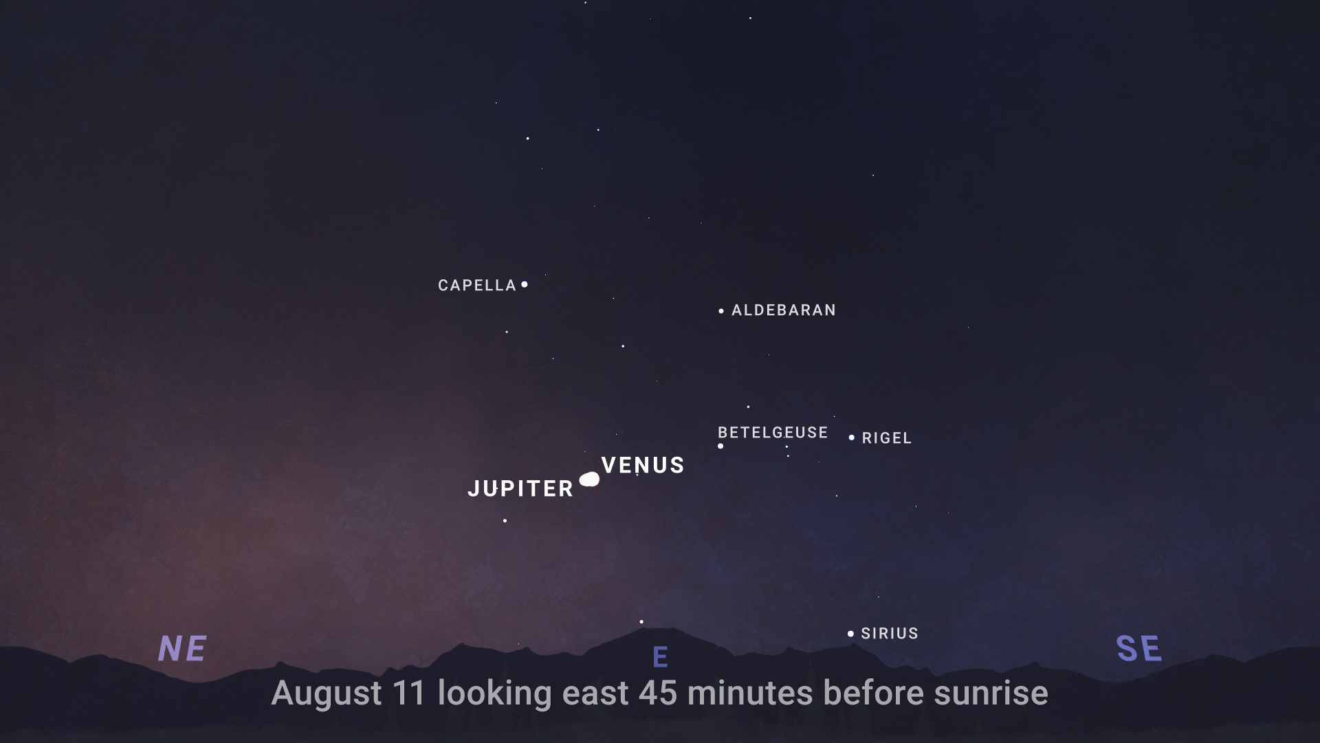
One of the best annual meteor showers, the Perseids, peaks overnight on August 12th and into the 13th. Unfortunately, this year the Moon is nearly full on the peak night, and its glare will wash out all but the brightest meteors. While that’s not so great for Perseid watchers, the good news is that another favorite annual meteor shower, the Geminids, is poised for Moon-free viewing in December.
August is a great time to see one of the easiest-to-observe nebulas in the sky.
The Dumbbell Nebula, also known as M27, is high overhead on August nights. It’s a type of nebula called a “planetary nebula.”
A nebula is a giant cloud of gas and dust in space, and planetary nebulas are produced by stars like our Sun when they become old and nuclear fusion ceases inside them. They blow off their outer layers, leaving behind a small, hot remnant called a white dwarf. The white dwarf produces lots of bright ultraviolet light that illuminates the nebula from the inside, as the expanding shell of gas absorbs the UV light and re-radiates it as visible light.
The Dumbbell Nebula, nicknamed for its dumbbell-like shape, appears as a small, faint patch of light about a quarter of the width of the full moon in binoculars or a small telescope. It lies within the Summer Triangle, a pattern of stars that’s easy to find overhead in the August sky. You’ll find the nebula about a third of the way between its bright stars Altair and Deneb.
Sky chart showing the Summer Triangle asterism, with the location of the Dumbbell Nebula (M27) indicated. NASA/JPL-Caltech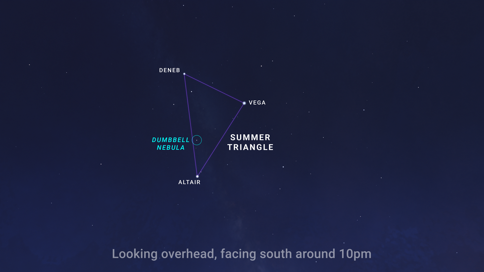
Here’s hoping you get a chance to observe this glimpse into the future that awaits our Sun about 5 billion years from now. It’s part of a cycle that seeds the galaxy with the ingredients for new generations of stars and planets — perhaps even some not too different from our own.
Here are the phases of the Moon for August.
The phases of the Moon for August 2025. NASA/JPL-Caltech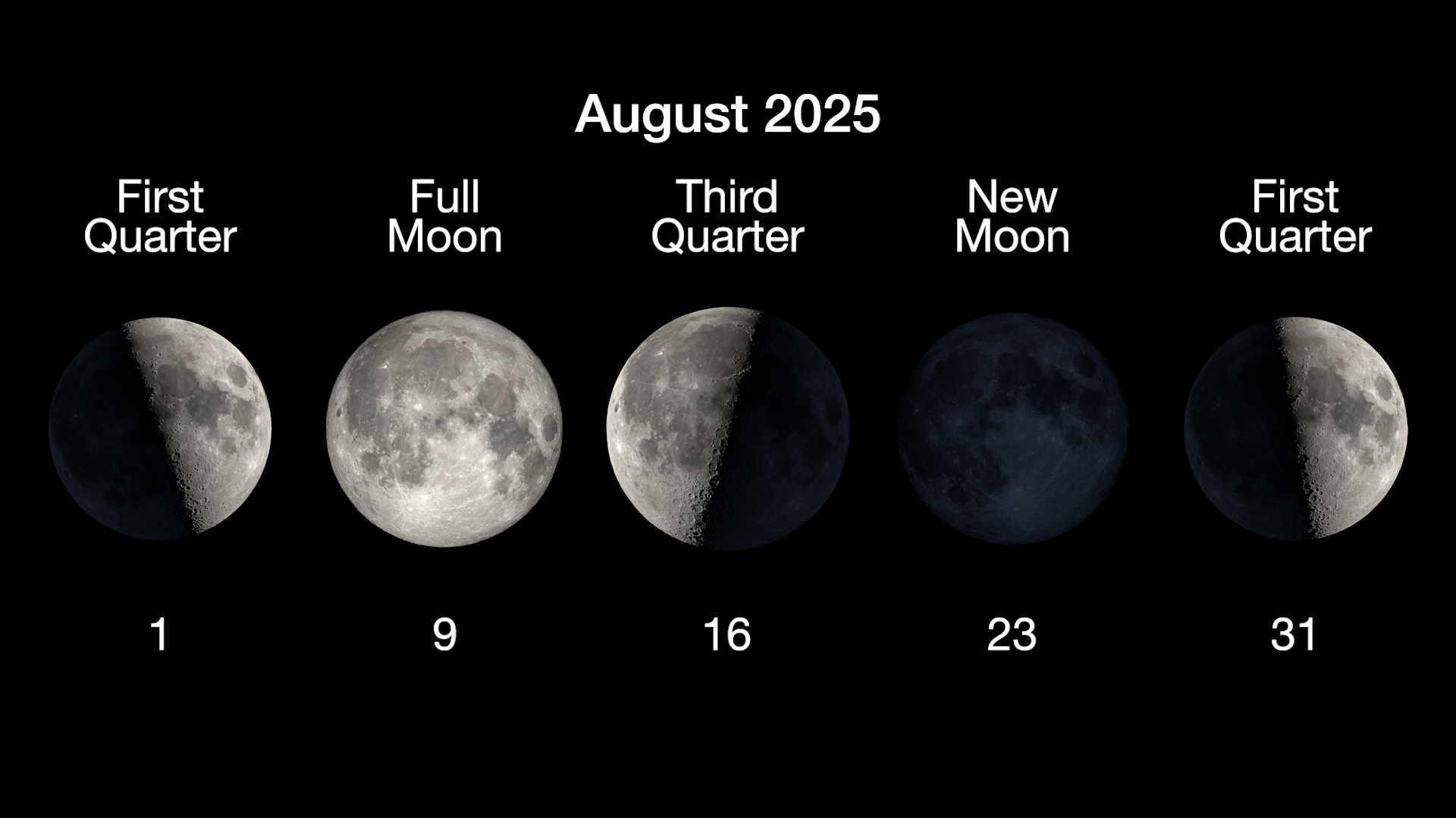
You can stay up to date on all of NASA’s missions exploring the solar system and beyond at science.nasa.gov. I’m Chelsea Gohd from NASA’s Jet Propulsion Laboratory, and that’s What’s Up for this month.
Keep Exploring Discover More Topics From NASA
Missions
Humans in Space
Climate Change
Solar System
What’s Up: August 2025 Skywatching Tips from NASA
Jupiter and Venus shine brightly in the mornings as they appear to graze each other in the sky on the 11th and 12th. The Perseids are washed out by the Moon.
Skywatching HighlightsAll Month – Planet Visibility:
- Mercury: Pops up above the horizon during the second half of August. Appears very low, below 10 degrees altitude.
- Venus: Shines very brightly in the east each morning before sunrise, about 20 to 30 degrees above the horizon.
- Mars: Can be observed low in the west during the hour after sunset, appearing about as bright as the brightest stars in the Big Dipper.
- Jupiter: Appears in the east each morning, together with Venus, but much less bright.
- Saturn: Observable late night to dawn. Rises around 10:30 p.m. early in the month, and around 8:30 p.m. by the end of the month. Find it high in the south as sunrise approaches.
Skywatching Highlights:
August 11 & 12 – Venus-Jupiter Conjunction – The two brightest planets have a close meetup over several days, appearing closest over two days on the 11th and 12th, at just a degree apart.
August 19 & 20 – Moon with Jupiter & Venus – A slim lunar crescent joins Jupiter and Venus — still relatively close in the sky after their conjunction. They appear in the east in the several hours preceding sunrise.
August 12th-13th – Perseids Peak – The celebrated annual meteor shower will be hampered by an 84%-full Moon on the peak night. A few bright meteors may still be seen in the pre-dawn hours, but viewing conditions are not ideal this year.
All month – The Dumbbell Nebula (M27) – One of the easiest planetary nebulas to observe, M27 appears within the Summer Triangle star pattern, high overhead in the first half of the night.
TranscriptWhat’s Up for August? Jupiter and Venus have a morning meetup, we check out this year’s Perseid meteor shower, and peek into the future of our own Sun.
Mars is the lone planet in the early evening sky this month, visible low in the west for about an hour after the sky starts to darken. It’s now only about 60% as bright as it appeared back in May.
Saturn is rising by about 10 pm, and you’ll see it showing up a bit earlier each evening as the month goes on. You’ll find it in the east after dark with the constellations Cassiopeia and Andromeda. The Ringed Planet makes its way over to the western part of the sky by dawn, where early risers will find it on August mornings.
The real highlight of August is the close approach of Jupiter and Venus. They shine brightly in the east before sunrise throughout the month. The pair begin the month farther apart, but quickly approach each other in the sky. They appear at their closest on the 11th and 12th — only about a degree apart. Their rendezvous happens against a backdrop of bright stars including Orion, Taurus, Gemini, and Sirius. A slim crescent Moon joins the pair of planets after they separate again, on the mornings of the 19th and 20th.
Sky chart showing the eastern sky before sunrise on August 11th, with Venus and Jupiter only a degree apart. NASA/JPL-CaltechOne of the best annual meteor showers, the Perseids, peaks overnight on August 12th and into the 13th. Unfortunately, this year the Moon is nearly full on the peak night, and its glare will wash out all but the brightest meteors. While that’s not so great for Perseid watchers, the good news is that another favorite annual meteor shower, the Geminids, is poised for Moon-free viewing in December.
August is a great time to see one of the easiest-to-observe nebulas in the sky.
The Dumbbell Nebula, also known as M27, is high overhead on August nights. It’s a type of nebula called a “planetary nebula.”
A nebula is a giant cloud of gas and dust in space, and planetary nebulas are produced by stars like our Sun when they become old and nuclear fusion ceases inside them. They blow off their outer layers, leaving behind a small, hot remnant called a white dwarf. The white dwarf produces lots of bright ultraviolet light that illuminates the nebula from the inside, as the expanding shell of gas absorbs the UV light and re-radiates it as visible light.
The Dumbbell Nebula, nicknamed for its dumbbell-like shape, appears as a small, faint patch of light about a quarter of the width of the full moon in binoculars or a small telescope. It lies within the Summer Triangle, a pattern of stars that’s easy to find overhead in the August sky. You’ll find the nebula about a third of the way between its bright stars Altair and Deneb.
Sky chart showing the Summer Triangle asterism, with the location of the Dumbbell Nebula (M27) indicated. NASA/JPL-CaltechHere’s hoping you get a chance to observe this glimpse into the future that awaits our Sun about 5 billion years from now. It’s part of a cycle that seeds the galaxy with the ingredients for new generations of stars and planets — perhaps even some not too different from our own.
Here are the phases of the Moon for August.
The phases of the Moon for August 2025. NASA/JPL-CaltechYou can stay up to date on all of NASA’s missions exploring the solar system and beyond at science.nasa.gov. I’m Chelsea Gohd from NASA’s Jet Propulsion Laboratory, and that’s What’s Up for this month.
Keep Exploring Discover More Topics From NASA
Missions
Humans in Space
Climate Change
Solar System
NASA’s SpaceX Crew-11 Launches to International Space Station
Four crew members of NASA’s SpaceX Crew-11 mission launched at 11:43 a.m. EDT Friday from Launch Complex 39A at the agency’s Kennedy Space Center in Florida for a science expedition aboard the International Space Station.
A SpaceX Falcon 9 rocket propelled the Dragon spacecraft into orbit carrying NASA astronauts Zena Cardman and Mike Fincke, JAXA (Japan Aerospace Exploration Agency) astronaut Kimiya Yui, and Roscosmos cosmonaut Oleg Platonov. The spacecraft will dock autonomously to the space-facing port of the station’s Harmony module at approximately 3 a.m. on Saturday, Aug. 2.
“Thanks to the bold leadership of President Donald J. Trump, NASA is back! The agency’s SpaceX Crew-11 mission to the space station is the first step toward our permanent presence on the Moon. NASA, in conjunction with great American companies, continues the mission with Artemis in 2026. This Moon mission will ensure America wins the space race – critical to national security – and leads in the emerging, exciting and highly profitable private sector commercial space business,” said acting NASA Administrator Sean Duffy. “The Commercial Crew Program and Artemis missions prove what American ingenuity, and cutting-edge American manufacturing can achieve. We’re going to the Moon…to stay! After that, we go to Mars! Welcome to the Golden Age of exploration!”
During Dragon’s flight, SpaceX will monitor a series of automatic spacecraft maneuvers from its mission control center in Hawthorne, California. NASA will monitor space station operations throughout the flight from the Mission Control Center at the agency’s Johnson Space Center in Houston.
NASA’s live coverage resumes at 1 a.m., Aug. 2, on NASA+ with rendezvous, docking, and hatch opening. After docking, the crew will change out of their spacesuits and prepare cargo for offload before opening the hatch between Dragon and the space station’s Harmony module around 4:45 a.m. Once the new crew is aboard the orbital outpost, NASA will provide coverage of the welcome ceremony beginning at approximately 5:45 a.m.
Learn how to watch NASA content through a variety of platforms, including social media.
The number of crew aboard the space station will increase to 11 for a short time as Crew-11 joins NASA astronauts Anne McClain, Nichole Ayers, and Jonny Kim, JAXA astronaut Takuya Onishi, and Roscosmos cosmonauts Kirill Peskov, Sergey Ryzhikov, and Alexey Zubritsky.
NASA’s SpaceX Crew-10 will depart the space station after the arrival of Crew-11 and a handover period. Ahead of Crew-10’s return, mission teams will review weather conditions at the splashdown sites off the coast of California prior to departure from station.
During their mission, Crew-11 will conduct scientific research to prepare for human exploration beyond low Earth orbit and benefit humanity on Earth. Participating crew members will simulate lunar landings, test strategies to safeguard vision, and advance other human spaceflight studies led by NASA’s Human Research Program. The crew also will study plant cell division and microgravity’s effects on bacteria-killing viruses, as well as perform experiments to produce a higher volume of human stem cells and generate on-demand nutrients.
The mission is part of NASA’s Commercial Crew Program, which provides reliable access to space, maximizing the use of the station for research and development and supporting future missions beyond low Earth orbit by partnering with private companies to transport astronauts to and from the space station.
Learn more about the agency’s Commercial Crew Program at:
https://www.nasa.gov/commercialcrew
-end-
Josh Finch / Claire O’Shea
Headquarters, Washington
202-358-1100
joshua.a.finch@nasa.gov / claire.a.o’shea@nasa.gov
Steven Siceloff
Kennedy Space Center, Florida
321-867-2468
steven.p.siceloff@nasa.gov
Sandra Jones
Johnson Space Center, Houston
281-483-5111
sandra.p.jones@nasa.gov
Best camera for astro now $300 cheaper: This Nikon bundle comes with plenty of extras
SpaceX launches Crew-11 astronauts to the ISS for NASA on milestone Crew Dragon flight (video)
DNA analysis reveals what really killed Napoleon's army in 1812
DNA analysis reveals what really killed Napoleon's army in 1812
New discovery at CERN could hint at why our universe is made up of matter and not antimatter
How Joint NASA-ESA Sea Level Mission Will Help Hurricane Forecasts
6 min read
Preparations for Next Moonwalk Simulations Underway (and Underwater) Sea surface height can tell meteorologists a lot about extreme storms like hurricanes, including whether they will intensify within a day. This kind of information can help communities better prepare if a hurricane is headed their way. Hurricane Elena is seen here from the space shuttle Discovery in 1985.NASA
Sentinel-6B will measure sea surface height for nearly all of the world’s ocean, providing important data for information products, including weather and hurricane forecasts.
NASA has a long record of monitoring Earth’s sea surface height, information critical not only for tracking how the ocean changes over time but also for hurricane forecasting. These extreme storms can cost the United States billions of dollars each year, wreaking havoc on lives and property. Meteorologists have worked to improve forecasts for a hurricane’s path, or track, as well as its intensity, measured as surface wind speed. Sentinel-6B, the U.S.-European satellite launching later this year, will help in that effort.
The satellite is the second of two spacecraft that constitute the Sentinel-6/Jason-CS (Continuity of Service) mission, a collaboration between NASA, ESA (European Space Agency), EUMETSAT (the European Organisation for the Exploitation of Meteorological Satellites), and the U.S. National Oceanic and Atmospheric Administration (NOAA). With its launch planned for no earlier than Nov. 16, 2025, Sentinel-6B will take over from its twin, Sentinel-6 Michael Freilich, which launched in November 2020 as part of a long line of U.S.-European missions that have monitored sea levels since 1992.
“Sentinel-6 will track global changes in Earth’s ocean — height, heat, and movement — and will improve forecasts of local extremes like floods and hurricanes, linking planetary trends to real-world risks for communities,” said Nadya Vinogradova Shiffer, Sentinel-6 program scientist at NASA Headquarters in Washington.
before after beforeafter before afterBefore and After
Hurricane Milton CurtainToggle2-Up Image Details These illustrations show ocean heat on Oct. 7, 2024, left, and Oct. 9, right, as Hurricane Milton passed over very warm seawater and rapidly grew. Red and yellow indicate more heat; blue and green are cooler. A satellite image of the hurricane shows the storm’s position as it moves toward Florida’s west coast. Credit: NOAAThe decades-long, U.S.-European ocean dataset has been key to helping researchers advance hurricane intensity forecasting. Warm water fuels hurricanes. And since water expands as it warms, sea surface height can tell researchers which regions of the ocean are warm enough to supercharge a hurricane.
“A deep layer of warm seawater is literally taller than a shallow layer of warm water,” said Josh Willis, Sentinel-6B project scientist at NASA’s Jet Propulsion Laboratory in Southern California. So sea surface height can be used as a proxy for the amount of heat in the ocean.
Fueling HurricanesThere are two main ways that forecasters use sea level measurements, said Mark DeMaria, a senior research scientist at Colorado State University in Fort Collins. One way is to help set the proper ocean conditions in ocean-atmosphere hurricane forecast models utilized by the National Hurricane Center.
The second way is by feeding sea level data into machine learning models that forecasters use to predict whether a hurricane will undergo rapid intensification, where its wind speeds increase by 35 mph (56 kph) or more within 24 hours. Meteorologists include both water temperature measurements from sensors drifting in the ocean and sea surface height data collected by Sentinel-6 Michael Freilich as well as other satellites.
Hurricanes churn the ocean as they pass overhead, mixing the top layers of seawater. If the storm encounters a shallow pool of warm seawater, its winds can stir things up, pulling cooler waters from the depths to the surface. This can hinder rapid intensification. But if the warm pool of seawater extends deep into the ocean, those winds will only stir up more warm water, potentially resulting in the hurricane’s rapid intensification.
“Hurricane Milton is a perfect example of this,” said DeMaria, who was previously a branch chief at the National Hurricane Center in Miami and helped to develop hurricane intensity forecast models. Milton experienced an intense period of rapid intensification — an event that was forecast using a model fed partly with data from Sentinel-6 Michael Freilich. From Oct. 6 to Oct. 7, 2024, Milton exploded from a Category 1 hurricane to a Category 5, producing wind speeds as high as 180 mph (289 kph). The storm weakened to a Category 3 — still a major hurricane — by the time it made landfall near Sarasota, Florida, on Oct. 9.
Forecast ImprovementsWhile the U.S.-European series of sea level satellites began collecting measurements in 1992, it wasn’t until the early 2000s that meteorologists started working with data from satellites in operational hurricane intensity forecasts such as the ones used by the National Hurricane Center. Before then, forecasts relied on models and ocean surface temperature measurements that weren’t always able to identify warm, deep pools of seawater that could induce rapid intensification in a hurricane.
Improvement efforts got a boost when the U.S. federal government started a program in 2007 aimed at advancing these types of forecasts. Since then, the program has helped move improvements made in the research realm — such as in hurricane forecast reliability and accuracy, extensions in the lead time for predictions, and reduced forecast uncertainty — into operational use.
The investment has been money well spent, said Renato Molina, an economist at the University of Miami who has analyzed the economic impact of improving hurricane forecasts. An accurate, timely forecast can give communities time to prepare, such as by boarding up homes and businesses or evacuating an area. The monetary savings can reach into the billions, he added.
While a host of atmospheric and oceanic characteristics go into hurricane forecasts, the inclusion of sea level data from satellites like Sentinel-6 Michael Freilich and, soon, Sentinel-6B has been an important addition. “We need data from sensors in the ocean as well as satellite data — they go hand-in-hand,” said DeMaria. “It would be impossible to do what we do without the satellites.”
More About Sentinel-6BSentinel-6/Jason-CS was jointly developed by ESA, EUMETSAT, NASA, and NOAA, with funding support from the European Commission and technical support from France’s space agency CNES (Centre National d’Études Spatiales).
NASA JPL, a division of Caltech in Pasadena, contributed three science instruments for each Sentinel-6 satellite: the Advanced Microwave Radiometer, the Global Navigation Satellite System – Radio Occultation, and the Laser Retroreflector Array. NASA is also contributing launch services, ground systems supporting operation of the NASA science instruments, the science data processors for two of these instruments, and support for the U.S. members of the international Ocean Surface Topography Science Team.
For more about Sentinel-6/Jason-CS, visit:
https://sealevel.jpl.nasa.gov/missions/jason-cs-sentinel-6
News Media ContactsJane J. Lee / Andrew Wang
Jet Propulsion Laboratory, Pasadena, Calif.
626-491-1943 / 626-379-6874
jane.j.lee@jpl.nasa.gov / andrew.wang@jpl.nasa.gov
2025-096
Share Details Last Updated Aug 01, 2025 Related Terms Explore More 5 min read NASA’s Europa Clipper Radar Instrument Proves Itself at Mars Article 3 days ago 5 min read How NASA Is Testing AI to Make Earth-Observing Satellites Smarter Article 2 weeks ago 5 min read NASA Shares How to Save Camera 370-Million-Miles Away Near Jupiter Article 2 weeks ago Keep Exploring Discover Related TopicsMissions
Humans in Space
Climate Change
Solar System
How Joint NASA-ESA Sea Level Mission Will Help Hurricane Forecasts
6 min read
Preparations for Next Moonwalk Simulations Underway (and Underwater) Sea surface height can tell meteorologists a lot about extreme storms like hurricanes, including whether they will intensify within a day. This kind of information can help communities better prepare if a hurricane is headed their way. Hurricane Elena is seen here from the space shuttle Discovery in 1985.NASASentinel-6B will measure sea surface height for nearly all of the world’s ocean, providing important data for information products, including weather and hurricane forecasts.
NASA has a long record of monitoring Earth’s sea surface height, information critical not only for tracking how the ocean changes over time but also for hurricane forecasting. These extreme storms can cost the United States billions of dollars each year, wreaking havoc on lives and property. Meteorologists have worked to improve forecasts for a hurricane’s path, or track, as well as its intensity, measured as surface wind speed. Sentinel-6B, the U.S.-European satellite launching later this year, will help in that effort.
The satellite is the second of two spacecraft that constitute the Sentinel-6/Jason-CS (Continuity of Service) mission, a collaboration between NASA, ESA (European Space Agency), EUMETSAT (the European Organisation for the Exploitation of Meteorological Satellites), and the U.S. National Oceanic and Atmospheric Administration (NOAA). With its launch planned for no earlier than Nov. 16, 2025, Sentinel-6B will take over from its twin, Sentinel-6 Michael Freilich, which launched in November 2020 as part of a long line of U.S.-European missions that have monitored sea levels since 1992.
“Sentinel-6 will track global changes in Earth’s ocean — height, heat, and movement — and will improve forecasts of local extremes like floods and hurricanes, linking planetary trends to real-world risks for communities,” said Nadya Vinogradova Shiffer, Sentinel-6 program scientist at NASA Headquarters in Washington.
before after beforeafter before afterBefore and After
Hurricane Milton CurtainToggle2-Up Image Details These illustrations show ocean heat on Oct. 7, 2024, left, and Oct. 9, right, as Hurricane Milton passed over very warm seawater and rapidly grew. Red and yellow indicate more heat; blue and green are cooler. A satellite image of the hurricane shows the storm’s position as it moves toward Florida’s west coast. Credit: NOAAThe decades-long, U.S.-European ocean dataset has been key to helping researchers advance hurricane intensity forecasting. Warm water fuels hurricanes. And since water expands as it warms, sea surface height can tell researchers which regions of the ocean are warm enough to supercharge a hurricane.
“A deep layer of warm seawater is literally taller than a shallow layer of warm water,” said Josh Willis, Sentinel-6B project scientist at NASA’s Jet Propulsion Laboratory in Southern California. So sea surface height can be used as a proxy for the amount of heat in the ocean.
Fueling HurricanesThere are two main ways that forecasters use sea level measurements, said Mark DeMaria, a senior research scientist at Colorado State University in Fort Collins. One way is to help set the proper ocean conditions in ocean-atmosphere hurricane forecast models utilized by the National Hurricane Center.
The second way is by feeding sea level data into machine learning models that forecasters use to predict whether a hurricane will undergo rapid intensification, where its wind speeds increase by 35 mph (56 kph) or more within 24 hours. Meteorologists include both water temperature measurements from sensors drifting in the ocean and sea surface height data collected by Sentinel-6 Michael Freilich as well as other satellites.
Hurricanes churn the ocean as they pass overhead, mixing the top layers of seawater. If the storm encounters a shallow pool of warm seawater, its winds can stir things up, pulling cooler waters from the depths to the surface. This can hinder rapid intensification. But if the warm pool of seawater extends deep into the ocean, those winds will only stir up more warm water, potentially resulting in the hurricane’s rapid intensification.
“Hurricane Milton is a perfect example of this,” said DeMaria, who was previously a branch chief at the National Hurricane Center in Miami and helped to develop hurricane intensity forecast models. Milton experienced an intense period of rapid intensification — an event that was forecast using a model fed partly with data from Sentinel-6 Michael Freilich. From Oct. 6 to Oct. 7, 2024, Milton exploded from a Category 1 hurricane to a Category 5, producing wind speeds as high as 180 mph (289 kph). The storm weakened to a Category 3 — still a major hurricane — by the time it made landfall near Sarasota, Florida, on Oct. 9.
Forecast ImprovementsWhile the U.S.-European series of sea level satellites began collecting measurements in 1992, it wasn’t until the early 2000s that meteorologists started working with data from satellites in operational hurricane intensity forecasts such as the ones used by the National Hurricane Center. Before then, forecasts relied on models and ocean surface temperature measurements that weren’t always able to identify warm, deep pools of seawater that could induce rapid intensification in a hurricane.
Improvement efforts got a boost when the U.S. federal government started a program in 2007 aimed at advancing these types of forecasts. Since then, the program has helped move improvements made in the research realm — such as in hurricane forecast reliability and accuracy, extensions in the lead time for predictions, and reduced forecast uncertainty — into operational use.
The investment has been money well spent, said Renato Molina, an economist at the University of Miami who has analyzed the economic impact of improving hurricane forecasts. An accurate, timely forecast can give communities time to prepare, such as by boarding up homes and businesses or evacuating an area. The monetary savings can reach into the billions, he added.
While a host of atmospheric and oceanic characteristics go into hurricane forecasts, the inclusion of sea level data from satellites like Sentinel-6 Michael Freilich and, soon, Sentinel-6B has been an important addition. “We need data from sensors in the ocean as well as satellite data — they go hand-in-hand,” said DeMaria. “It would be impossible to do what we do without the satellites.”
More About Sentinel-6BSentinel-6/Jason-CS was jointly developed by ESA, EUMETSAT, NASA, and NOAA, with funding support from the European Commission and technical support from France’s space agency CNES (Centre National d’Études Spatiales).
NASA JPL, a division of Caltech in Pasadena, contributed three science instruments for each Sentinel-6 satellite: the Advanced Microwave Radiometer, the Global Navigation Satellite System – Radio Occultation, and the Laser Retroreflector Array. NASA is also contributing launch services, ground systems supporting operation of the NASA science instruments, the science data processors for two of these instruments, and support for the U.S. members of the international Ocean Surface Topography Science Team.
For more about Sentinel-6/Jason-CS, visit:
https://sealevel.jpl.nasa.gov/missions/jason-cs-sentinel-6
News Media ContactsJane J. Lee / Andrew Wang
Jet Propulsion Laboratory, Pasadena, Calif.
626-491-1943 / 626-379-6874
jane.j.lee@jpl.nasa.gov / andrew.wang@jpl.nasa.gov
2025-096
Share Details Last Updated Aug 01, 2025 Related Terms Explore More 5 min read NASA’s Europa Clipper Radar Instrument Proves Itself at Mars Article 3 days ago 5 min read How NASA Is Testing AI to Make Earth-Observing Satellites Smarter Article 2 weeks ago 5 min read NASA Shares How to Save Camera 370-Million-Miles Away Near Jupiter Article 2 weeks ago Keep Exploring Discover Related TopicsMissions
Humans in Space
Climate Change
Solar System
Wildfire Smoke from Canada Reduces Air Quality in U.S. Midwest
Winds from the northwest are blowing cool, dry air—but also wildfire smoke—into the U.S. Midwest from Canada
Exotic 'blazar' is part of most extreme double black hole system ever found, crooked jet suggests
Big lake in Quebec suddenly disappears, satellite finds | Space photo of the day for August 1, 2025
Astronaut savors the moment and shares a stunning aurora shot | On the International Space Station July 28-Aug. 1, 2025
Week in images: 28 July - 1 August 2025
Week in images: 28 July - 1 August 2025
Discover our week through the lens
Stunning 'sun dogs' could sparkle in alien skies, James Webb Space Telescope suggests
U.S. Science Has Weathered Attacks Before and Won
Federal officials seized 3,000 copies of Scientific American in 1950 in a “red scare” era of attacks on science. The move backfired and offers lessons for today