
Feed aggregator
Octopuses fall for the rubber hand illusion just like us
We've discovered a door to a hidden part of reality – what's inside?
We've discovered a door to a hidden part of reality – what's inside?
'Most impressive!' Darth Vader's screen-used 'Star Wars' lightsaber could fetch $3 million in September auction
Humidity from Corn Sweat Intensifies Extreme Heat Wave in U.S. Midwest
Humid heat is blanketing the eastern U.S. this week, exacerbated by “corn sweat” in the Midwest
Could AI Have Prevented SkyWest Airliner’s Near Collision with a B-52 Bomber?
A SkyWest pilot’s last-second decision could have prevented a collision that air-traffic controllers may not have foreseen
5 Things to Know About Powerful New U.S.-India Satellite, NISAR
6 min read
Preparations for Next Moonwalk Simulations Underway (and Underwater) Information provided by the NASA-ISRO Synthetic Aperture Radar mission (NISAR) will help to protect and inform communities around the world. The data will aid in managing agricultural fields, monitoring volcanoes, and tracking land-based ice including glaciers.NASA/JPL-Caltech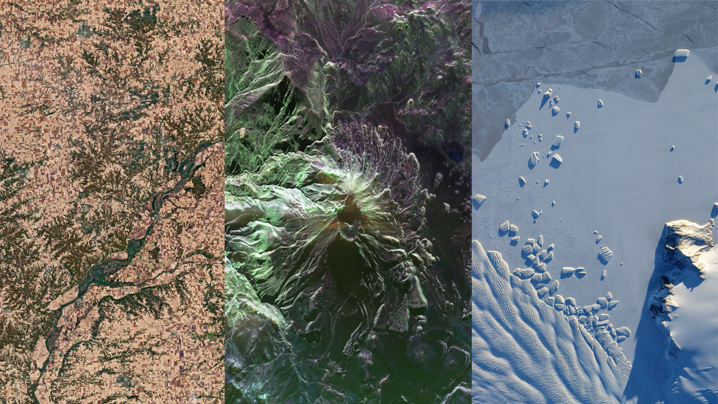
Lee esta historia en español aquí.
Data from NISAR will map changes to Earth’s surface, helping improve crop management, natural hazard monitoring, and tracking of sea ice and glaciers.
A new U.S.-India satellite called NISAR (NASA-ISRO Synthetic Aperture Radar) will provide high-resolution data enabling scientists to comprehensively monitor the planet’s land and ice surfaces like never before, building a detailed record of how they shift over time. Hailed as a critical part of a pioneering year for U.S.-India civil space cooperation by President Trump and Prime Minister Modi during their visit in Washington in February, the NISAR launch will advance U.S.-India cooperation and benefit the U.S. in the areas of disaster response and agriculture.
As the first joint satellite mission between NASA and the Indian Space Research Organisation (ISRO), NISAR marks a new chapter in the growing collaboration between the two space agencies. Years in the making, the launch of NISAR builds on a strong heritage of successful programs, including Chandrayaan-1 and the recent Axiom Mission 4, which saw ISRO and NASA astronauts living and working together aboard the International Space Station for the first time.
The information NISAR provides will help decision-makers, communities, and scientists monitor agricultural fields, refine understanding of natural hazards such as landslides and earthquakes, and help teams prepare for and respond to disasters like hurricanes, floods, and volcanic eruptions. The satellite will also provide key global observations of changes to ice sheets, glaciers, and permafrost, as well as forests and wetlands.
The NISAR mission is slated to launch no earlier than July 30 from Satish Dhawan Space Centre on India’s southeastern coast aboard an ISRO Geosynchronous Satellite Launch Vehicle.
Here are five things to know about NISAR:
1. The NISAR satellite will provide a 3D view of Earth’s land and ice.
Two synthetic aperture radars (SARs) aboard NISAR will detect changes in the planet’s surface down to fractions of an inch. The spacecraft will bounce microwave signals off Earth’s surface and receive the return signals on a radar antenna reflector measuring 39 feet (12 meters) across. The satellite’s ability to “see” through clouds and light rain, day and night, will enable data users to continuously monitor earthquake- and landslide-prone areas and determine how quickly glaciers and ice sheets are changing. It also will offer unprecedented coverage of Antarctica, information that will help with studying how the continent’s ice sheet changes over time.
2. Data from NISAR will provide critical insights to help governments and decision-makers plan for natural and human-caused hazards.
Earthquakes, volcanoes, and aging infrastructure can pose risks to lives and property. Able to see subtle changes in Earth’s surface, NISAR can help with hazard-monitoring efforts and potentially give decision-makers more time to prepare for a possible disaster. For earthquakes, NISAR will provide insights into which parts of a fault slowly move without producing quakes and which are locked together and could potentially slip. The satellite will be able to monitor the area around thousands of volcanoes, detecting land movement that could be a precursor to an eruption. When it comes to infrastructure such as levees, aqueducts, and dams, NISAR data collected over time can help managers detect if nearby land motion could jeopardize key structures, and then assess the integrity of those facilities.
3. The most advanced radar system ever launched as part of a NASA or ISRO mission, NISAR will generate more data on a daily basis than any previous Earth satellite from either agency.
About the length of a pickup truck, NISAR’s main body contains a dual-radar payload — an L-band system with a 10-inch (25-centimeter) wavelength and an S-band system with a 4-inch (10-centimeter) wavelength. Each system is sensitive to land and ice features of different sizes and specializes in detecting certain attributes, such as moisture content, surface roughness, and motion. By including both radars on one spacecraft — a first — NISAR will be more capable than previous SAR missions. These two radars, one from NASA and one from ISRO, and the data they will produce, exemplify how collaboration between spacefaring allies can achieve more than either would alone.
NISAR press kitThe radars will generate about 80 terabytes of data products per day over the course of NISAR’s prime mission. That’s roughly enough data to fill about 150 512-gigabyte hard drives each day. The information will be processed, stored, and distributed via the cloud — and accessible to all.
This artist’s concept depicts the NISAR satellite in orbit over central and Northern California. The spacecraft will survey all of Earth’s land and ice-covered surfaces twice every 12 days.NASA/JPL-Caltech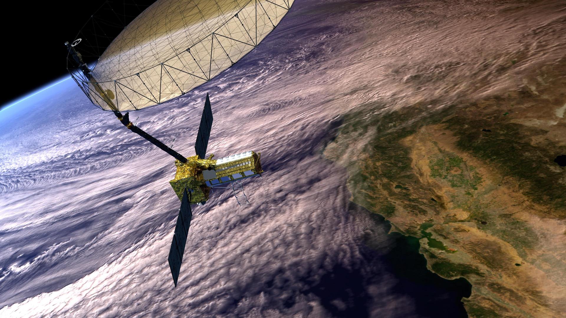
4. The NISAR mission will help monitor ecosystems around the world.
The mission’s two radars will monitor Earth’s land and ice-covered surfaces twice every 12 days. Their near-comprehensive coverage will include areas not previously covered by other Earth-observing radar satellites with such frequency. The NISAR satellite’s L-band radar penetrates deep into forest canopies, providing insights into forest structure, while the S-band radar is ideal for monitoring crops. The NISAR data will help researchers assess how forests, wetlands, agricultural areas, and permafrost change over time.
5. The NISAR mission marks the first collaboration between NASA and ISRO on a project of this scale and marks the next step in a long line of Earth-observing SAR missions.
The NISAR satellite features components developed on opposite sides of the planet by engineers from ISRO and NASA’s Jet Propulsion Laboratory working together. The S-band radar was built at ISRO’s Space Applications Centre in Ahmedabad, while JPL built the L-band radar in Southern California. After engineers from JPL and ISRO integrated NISAR’s instruments with a modified ISRO I3K spacecraft bus and tested the satellite, ISRO transported NISAR to Satish Dhawan Space Centre in May 2025 to prepare it for launch.
The SAR technique was invented in the U.S. in 1952 and now countries around the globe have SAR satellites for a variety of missions. NASA first used the technique with a space-based satellite in 1978 on the ocean-observing Seasat, which included the first spaceborne SAR instrument for scientific observations. In 2012, ISRO began launching SAR missions starting with Radar Imaging Satellite (RISAT-1), followed by RISAT-1A in 2022, to support a wide range of applications in India.
More About NISARManaged by Caltech in Pasadena, JPL leads the U.S. component of the project and provided the L-band SAR. JPL also provided the radar reflector antenna, the deployable boom, a high-rate communication subsystem for science data, GPS receivers, a solid-state recorder, and payload data subsystem. NASA’s Goddard Space Flight Center manages the Near Space Network, which will receive NISAR’s L-band data.
The ISRO Space Applications Centre is providing the mission’s S-band SAR. The U R Rao Satellite Centre is providing the spacecraft bus. The rocket is from Vikram Sarabhai Space Centre, launch services are through Satish Dhawan Space Centre, and satellite mission operations are by the ISRO Telemetry Tracking and Command Network. The National Remote Sensing Centre is responsible for S-band data reception, operational products generation, and dissemination.
To learn more about NISAR, visit:
How New NASA, India Satellite NISAR Will See Earth Powerful New US-Indian Satellite Will Track Earth’s Changing Surface NASA-ISRO Radar Mission to Provide Dynamic View of Forests, Wetlands NASA-ISRO Mission Will Map Farmland From Planting to Harvest News Media ContactsAndrew Wang / Jane J. Lee
Jet Propulsion Laboratory, Pasadena, Calif.
626-379-6874 / 626-491-1943
andrew.wang@jpl.nasa.gov / jane.j.lee@jpl.nasa.gov
2025-090
Share Details Last Updated Jul 21, 2025 Related Terms Explore More 5 min read NASA Shares How to Save Camera 370-Million-Miles Away Near Jupiter Article 22 hours ago 2 min read GLOBE-Trotting Science Lands in Chesapeake with NASA eClipsOn June 16-17, 2025, 50 students at Camp Young in Chesapeake, Virginia traded their usual…
Article 22 hours ago 4 min read Linking Satellite Data and Community Knowledge to Advance Alaskan Snow ScienceSeasonal snow plays a significant role in global water and energy cycles, and billions of…
Article 1 week ago Keep Exploring Discover Related TopicsMissions
Humans in Space
Climate Change
Solar System
5 Things to Know About Powerful New U.S.-India Satellite, NISAR
6 min read
Preparations for Next Moonwalk Simulations Underway (and Underwater) Information provided by the NASA-ISRO Synthetic Aperture Radar mission (NISAR) will help to protect and inform communities around the world. The data will aid in managing agricultural fields, monitoring volcanoes, and tracking land-based ice including glaciers.NASA/JPL-CaltechLee esta historia en español aquí.
Data from NISAR will map changes to Earth’s surface, helping improve crop management, natural hazard monitoring, and tracking of sea ice and glaciers.
A new U.S.-India satellite called NISAR (NASA-ISRO Synthetic Aperture Radar) will provide high-resolution data enabling scientists to comprehensively monitor the planet’s land and ice surfaces like never before, building a detailed record of how they shift over time. Hailed as a critical part of a pioneering year for U.S.-India civil space cooperation by President Trump and Prime Minister Modi during their visit in Washington in February, the NISAR launch will advance U.S.-India cooperation and benefit the U.S. in the areas of disaster response and agriculture.
As the first joint satellite mission between NASA and the Indian Space Research Organisation (ISRO), NISAR marks a new chapter in the growing collaboration between the two space agencies. Years in the making, the launch of NISAR builds on a strong heritage of successful programs, including Chandrayaan-1 and the recent Axiom Mission 4, which saw ISRO and NASA astronauts living and working together aboard the International Space Station for the first time.
The information NISAR provides will help decision-makers, communities, and scientists monitor agricultural fields, refine understanding of natural hazards such as landslides and earthquakes, and help teams prepare for and respond to disasters like hurricanes, floods, and volcanic eruptions. The satellite will also provide key global observations of changes to ice sheets, glaciers, and permafrost, as well as forests and wetlands.
The NISAR mission is slated to launch no earlier than July 30 from Satish Dhawan Space Centre on India’s southeastern coast aboard an ISRO Geosynchronous Satellite Launch Vehicle.
Here are five things to know about NISAR:
1. The NISAR satellite will provide a 3D view of Earth’s land and ice.
Two synthetic aperture radars (SARs) aboard NISAR will detect changes in the planet’s surface down to fractions of an inch. The spacecraft will bounce microwave signals off Earth’s surface and receive the return signals on a radar antenna reflector measuring 39 feet (12 meters) across. The satellite’s ability to “see” through clouds and light rain, day and night, will enable data users to continuously monitor earthquake- and landslide-prone areas and determine how quickly glaciers and ice sheets are changing. It also will offer unprecedented coverage of Antarctica, information that will help with studying how the continent’s ice sheet changes over time.
2. Data from NISAR will provide critical insights to help governments and decision-makers plan for natural and human-caused hazards.
Earthquakes, volcanoes, and aging infrastructure can pose risks to lives and property. Able to see subtle changes in Earth’s surface, NISAR can help with hazard-monitoring efforts and potentially give decision-makers more time to prepare for a possible disaster. For earthquakes, NISAR will provide insights into which parts of a fault slowly move without producing quakes and which are locked together and could potentially slip. The satellite will be able to monitor the area around thousands of volcanoes, detecting land movement that could be a precursor to an eruption. When it comes to infrastructure such as levees, aqueducts, and dams, NISAR data collected over time can help managers detect if nearby land motion could jeopardize key structures, and then assess the integrity of those facilities.
3. The most advanced radar system ever launched as part of a NASA or ISRO mission, NISAR will generate more data on a daily basis than any previous Earth satellite from either agency.
About the length of a pickup truck, NISAR’s main body contains a dual-radar payload — an L-band system with a 10-inch (25-centimeter) wavelength and an S-band system with a 4-inch (10-centimeter) wavelength. Each system is sensitive to land and ice features of different sizes and specializes in detecting certain attributes, such as moisture content, surface roughness, and motion. By including both radars on one spacecraft — a first — NISAR will be more capable than previous SAR missions. These two radars, one from NASA and one from ISRO, and the data they will produce, exemplify how collaboration between spacefaring allies can achieve more than either would alone.
NISAR press kitThe radars will generate about 80 terabytes of data products per day over the course of NISAR’s prime mission. That’s roughly enough data to fill about 150 512-gigabyte hard drives each day. The information will be processed, stored, and distributed via the cloud — and accessible to all.
This artist’s concept depicts the NISAR satellite in orbit over central and Northern California. The spacecraft will survey all of Earth’s land and ice-covered surfaces twice every 12 days.NASA/JPL-Caltech4. The NISAR mission will help monitor ecosystems around the world.
The mission’s two radars will monitor Earth’s land and ice-covered surfaces twice every 12 days. Their near-comprehensive coverage will include areas not previously covered by other Earth-observing radar satellites with such frequency. The NISAR satellite’s L-band radar penetrates deep into forest canopies, providing insights into forest structure, while the S-band radar is ideal for monitoring crops. The NISAR data will help researchers assess how forests, wetlands, agricultural areas, and permafrost change over time.
5. The NISAR mission marks the first collaboration between NASA and ISRO on a project of this scale and marks the next step in a long line of Earth-observing SAR missions.
The NISAR satellite features components developed on opposite sides of the planet by engineers from ISRO and NASA’s Jet Propulsion Laboratory working together. The S-band radar was built at ISRO’s Space Applications Centre in Ahmedabad, while JPL built the L-band radar in Southern California. After engineers from JPL and ISRO integrated NISAR’s instruments with a modified ISRO I3K spacecraft bus and tested the satellite, ISRO transported NISAR to Satish Dhawan Space Centre in May 2025 to prepare it for launch.
The SAR technique was invented in the U.S. in 1952 and now countries around the globe have SAR satellites for a variety of missions. NASA first used the technique with a space-based satellite in 1978 on the ocean-observing Seasat, which included the first spaceborne SAR instrument for scientific observations. In 2012, ISRO began launching SAR missions starting with Radar Imaging Satellite (RISAT-1), followed by RISAT-1A in 2022, to support a wide range of applications in India.
More About NISARManaged by Caltech in Pasadena, JPL leads the U.S. component of the project and provided the L-band SAR. JPL also provided the radar reflector antenna, the deployable boom, a high-rate communication subsystem for science data, GPS receivers, a solid-state recorder, and payload data subsystem. NASA’s Goddard Space Flight Center manages the Near Space Network, which will receive NISAR’s L-band data.
The ISRO Space Applications Centre is providing the mission’s S-band SAR. The U R Rao Satellite Centre is providing the spacecraft bus. The rocket is from Vikram Sarabhai Space Centre, launch services are through Satish Dhawan Space Centre, and satellite mission operations are by the ISRO Telemetry Tracking and Command Network. The National Remote Sensing Centre is responsible for S-band data reception, operational products generation, and dissemination.
To learn more about NISAR, visit:
How New NASA, India Satellite NISAR Will See Earth Powerful New US-Indian Satellite Will Track Earth’s Changing Surface NASA-ISRO Radar Mission to Provide Dynamic View of Forests, Wetlands NASA-ISRO Mission Will Map Farmland From Planting to Harvest News Media ContactsAndrew Wang / Jane J. Lee
Jet Propulsion Laboratory, Pasadena, Calif.
626-379-6874 / 626-491-1943
andrew.wang@jpl.nasa.gov / jane.j.lee@jpl.nasa.gov
2025-090
Share Details Last Updated Jul 21, 2025 Related Terms Explore More 5 min read NASA Shares How to Save Camera 370-Million-Miles Away Near Jupiter Article 14 hours ago 2 min read GLOBE-Trotting Science Lands in Chesapeake with NASA eClipsOn June 16-17, 2025, 50 students at Camp Young in Chesapeake, Virginia traded their usual…
Article 14 hours ago 4 min read Linking Satellite Data and Community Knowledge to Advance Alaskan Snow ScienceSeasonal snow plays a significant role in global water and energy cycles, and billions of…
Article 1 week ago Keep Exploring Discover Related TopicsMissions
Humans in Space
Climate Change
Solar System
Astronomers crack 1,000-year-old Betelgeuse mystery with 1st-ever sighting of secret companion (photo, video)
ESA selects 5 rocket companies for European Launcher Challenge
How Humility Can Restore Trust in Expertise
Acknowledging the limits of one’s own knowledge could be as important a signal of expertise as credentials and confidence
Bring NASA Science into Your Library!
2 min read
Bring NASA Science into Your Library!Calling all librarians! NASA sponsors dozens of research projects that need help from you and the people in your community. These projects invite everyone who’s interested to collaborate with scientists, investigating mysteries from how star systems form to how our planet sustains life. You can help by making observations with your cell phone or by studying fresh data on your laptop from spacecraft like the James Webb Space Telescope. You might discover a near-Earth asteroid or a new food option for astronauts. Participants learn new skills and meet scientists and other people around the world with similar interests.
Interested in sharing these opportunities with your patrons? Join us on August 26, 2025 at 1 p.m. EST for a 1-hour online information session. A librarian and a participatory science professional will provide you with a NASA Citizen Science Librarian Starter Kit and answer all your questions. The kit includes everything you need to host a NASA Science Program for patrons of all ages.
- Editable poster to advertise event
- Event prep guide (for the host and for the space)
- Community connection ideas
- Editable event agenda
- Handout for participants
Scan the QR code above or go to https://shorturl.at/tKfTt to register for the session.
Kara Reiman, Librarian and Educator (Left) and Sarah Kirn, Participatory Science Strategist, NASA (Right) Share Details Last Updated Jul 21, 2025 Related Terms Explore More 3 min read NASA Citizen Science and Your Career: Stories of Exoplanet Watch Volunteers
Doing NASA Science brings many rewards. But can taking part in NASA citizen science help…
Article
5 days ago
2 min read Polar Tourists Give Positive Reviews to NASA Citizen Science in Antarctica
Article
2 weeks ago
2 min read NASA Citizen Scientists Find New Eclipsing Binary Stars
Article
4 weeks ago
Bring NASA Science into Your Library!
2 min read
Bring NASA Science into Your Library!Calling all librarians! NASA sponsors dozens of research projects that need help from you and the people in your community. These projects invite everyone who’s interested to collaborate with scientists, investigating mysteries from how star systems form to how our planet sustains life. You can help by making observations with your cell phone or by studying fresh data on your laptop from spacecraft like the James Webb Space Telescope. You might discover a near-Earth asteroid or a new food option for astronauts. Participants learn new skills and meet scientists and other people around the world with similar interests.
Interested in sharing these opportunities with your patrons? Join us on August 26, 2025 at 1 p.m. EST for a 1-hour online information session. A librarian and a participatory science professional will provide you with a NASA Citizen Science Librarian Starter Kit and answer all your questions. The kit includes everything you need to host a NASA Science Program for patrons of all ages.
- Editable poster to advertise event
- Event prep guide (for the host and for the space)
- Community connection ideas
- Editable event agenda
- Handout for participants
Scan the QR code above or go to https://shorturl.at/tKfTt to register for the session.
Kara Reiman, Librarian and Educator (Left) and Sarah Kirn, Participatory Science Strategist, NASA (Right) Share Details Last Updated Jul 21, 2025 Related Terms Explore More 3 min read NASA Citizen Science and Your Career: Stories of Exoplanet Watch VolunteersDoing NASA Science brings many rewards. But can taking part in NASA citizen science help…
Article
5 days ago
2 min read Polar Tourists Give Positive Reviews to NASA Citizen Science in Antarctica
Article
2 weeks ago
2 min read NASA Citizen Scientists Find New Eclipsing Binary Stars
Article
4 weeks ago
Amateur astrophotographer captures trio of breathtaking nebulas from the Central Australian Desert (photos)
Should we preserve the pre-AI internet before it is contaminated?
Should we preserve the pre-AI internet before it is contaminated?
Astronauts collect blood aboard the ISS | Space photo of the day for July 21, 2025
Immortal stars could live forever by 'eating' dark matter
Immortal stars could live forever by 'eating' dark matter
Landmark Langlands Proof Advances Grand Unified Theory of Math
The Langlands program has inspired and befuddled mathematicians for more than 50 years. A major advance has now opened up new worlds for them to explore