
Feed aggregator
One of NASA’s Key Cameras Orbiting Mars Takes 100,000th Image
3 min read
Preparations for Next Moonwalk Simulations Underway (and Underwater) This view of a region called Syrtis Major is from the 100,000th image captured by NASA’s Mars Reconnaissance Orbiter using its HiRISE camera. Over nearly 20 years, HiRISE has helped scientists understand how the Red Planet’s surface is constantly changing. NASA/JPL-Caltech/University of Arizona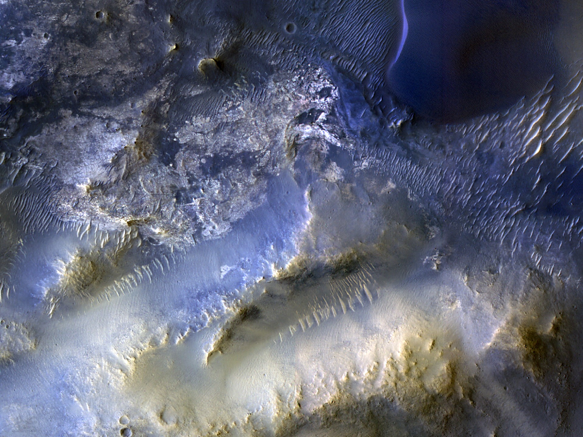
Mesas and dunes stand out in the view snapped by HiRISE, one of the imagers aboard the agency’s Mars Reconnaissance Orbiter.
After nearly 20 years at the Red Planet, NASA’s Mars Reconnaissance Orbiter (MRO) has snapped its 100,000th image of the surface with its HiRISE camera. Short for High Resolution Imaging Science Experiment, HiRISE is the instrument the mission relies on for high-resolution images of features ranging from impact craters, sand dunes, and ice deposits to potential landing sites. Those images, in turn, help improve our understanding of Mars and prepare for NASA’s future human missions there.
Captured Oct. 7, this milestone image from the spacecraft shows mesas and dunes within Syrtis Major, a region about 50 miles (80 kilometers) southeast of Jezero Crater, which NASA’s Perseverance rover is exploring. Scientists are analyzing the image to better understand the source of windblown sand that gets trapped in the region’s landscape, eventually forming dunes.
“HiRISE hasn’t just discovered how different the Martian surface is from Earth, it’s also shown us how that surface changes over time,” said MRO’s project scientist, Leslie Tamppari of NASA’s Jet Propulsion Laboratory in Southern California. “We’ve seen dune fields marching along with the wind and avalanches careening down steep slopes.”
To view this video please enable JavaScript, and consider upgrading to a web browser that supports HTML5 video
Watch highlights of images captured by HiRISE, the high-resolution camera aboard NASA’s Mars Reconnaissance Orbiter, including its 100,000th image, showing the plains and dunes of Syrtis Major.NASA/JPL-Caltech/University of ArizonaThe subject of the 100,000th image was recommended by a high school student through the HiWish site, where anyone can suggest parts of the planet to study. Team members at University of Arizona in Tucson, which operates the camera, also make 3D models of HiRISE imagery so that viewers can experience virtual flyover videos.
“Rapid data releases, as well as imaging targets suggested by the broader science community and public, have been a hallmark of HiRISE,” said the camera’s principal investigator, Shane Byrne of the University of Arizona in Tucson. “One hundred thousand images just like this one have made Mars more familiar and accessible for everyone.”
More about MRO
NASA’s Jet Propulsion Laboratory in Southern California manages MRO for NASA’s Science Mission Directorate in Washington as part of NASA’s Mars Exploration Program portfolio. Lockheed Martin Space in Denver built MRO and supports its operations.
The University of Arizona in Tucson operates HiRISE, which was built by Ball Aerospace & Technologies Corp., in Boulder, Colorado.
For more information, visit:
https://science.nasa.gov/mission/mars-reconnaissance-orbiter
MRO Captures Images of Comet 3I/ATLAS Mars Orbiter Shines New Light on Martian Mystery Mars Orbiter Learns New Moves After Nearly 20 YearsNews Media Contacts
Andrew Good
Jet Propulsion Laboratory, Pasadena, Calif.
818-393-2433
andrew.c.good@jpl.nasa.gov
Karen Fox / Molly Wasser
NASA Headquarters, Washington
202-358-1600
karen.c.fox@nasa.gov / molly.l.wasser@nasa.gov
2025-140
Share Details Last Updated Dec 16, 2025 Related Terms Explore More 6 min read NASA JPL Shakes Things Up Testing Future Commercial Lunar Spacecraft Article 1 hour ago 5 min read NASA, Partners Share First Data From New US-European Sea Satellite Article 7 hours ago 3 min read NASA’s Webb, Curiosity Named in TIME’s Best Inventions Hall of FameTwo icons of discovery, NASA’s James Webb Space Telescope and NASA’s Curiosity rover, have earned…
Article 4 days ago Keep Exploring Discover Related Topics Mars ExplorationMars is the only planet we know of inhabited entirely by robots. Learn more about the Mars Missions.
Mars Reconnaissance OrbiterNASA’s Mars Reconnaissance Orbiter (MRO) is the second longest-lived spacecraft to orbit Mars, after 2001 Mars Odyssey.
MRO ScienceOverview Among other ongoing achievements, data collected by Mars Reconnaissance Orbiter continues to help Mars scientists and engineers characterize potential…
All Mars ResourcesExplore this collection of Mars images, videos, resources, PDFs, and toolkits. Discover valuable content designed to inform, educate, and inspire,…
Maintaining the Gold Standard: The Future of Landsat Calibration and Validation
By Amit Angal, Senior Engineer at Goddard Space Flight Center
The Landsat Calibration and Validation (Cal/Val) group helps uphold Landsat’s reputation as the gold standard of satellite imagery. They ensure that the Operational Land Imager (OLI) and the Thermal Infrared Sensor (TIRS) aboard Landsats 8 and 9 provide high-quality scientific measurements to users around the world. In 2025, the Cal/Val group contributed over 60 pages to the second edition of “Comprehensive Remote Sensing” (Kaita et. al, 2026), organizing content from NASA, USGS, academia, and industry scientists. Cal/Val support staff authored multiple sections, including a summary of results from Landsat 9 and of the evolution of spectral, spatial, and radiometric characteristics throughout the Landsat missions.
A natural-color Landsat 9 image of Railroad Valley Playa in Nevada, acquired on June 29, 2024. A portion of the playa is used as a radiometric calibration and validation site for various satellite sensors including Landsat 8 and 9’s OLI instruments.NASA/USGS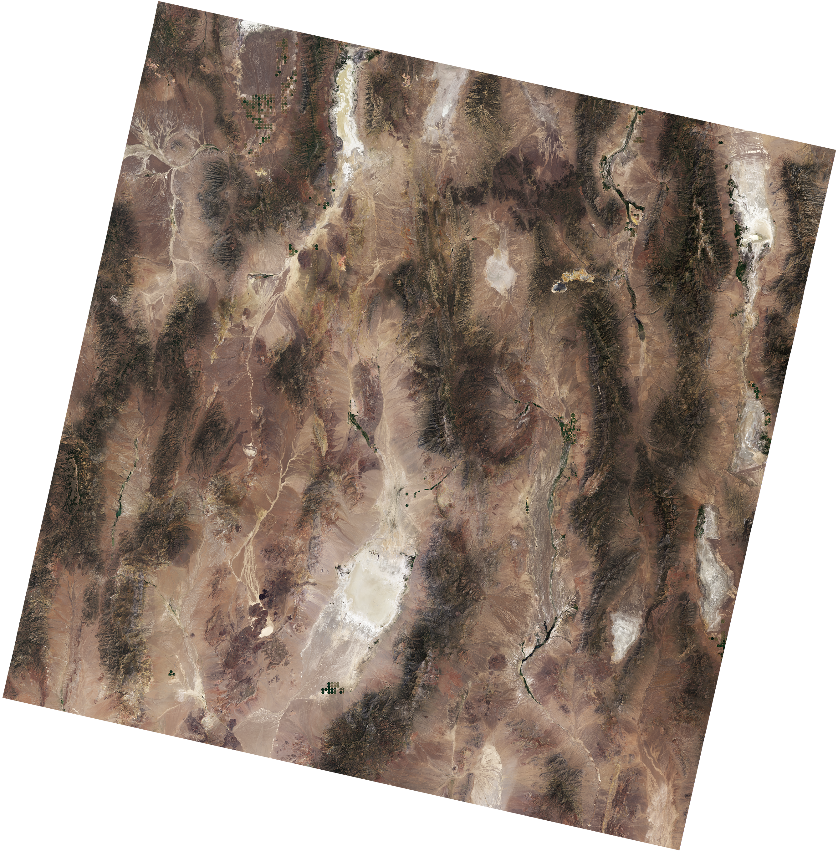
The Cal/Val team at NASA Goddard Space Flight Center works closely with the Landsat Flight Operations Team to plan weekly calibration activities to maintain the radiometric accuracy of Landsat products. In October 2025, a Landsat 9 anomaly occurred related to its solar array drive assembly (SADA) potentiometer. The spacecraft and instruments were placed in a safehold, pausing data collections. The Cal/Val team assessed the instruments after they recovered from this anomaly, including monitoring the instrument telemetry, detector gains, and noise performance. The team identified a mis-loaded detector map and updated the calibration of both the reflective and thermal emissive bands to ensure consistent, accurate data. After six days in the safehold, the instrument resumed normal operations.
The NASA Cal/Val team supports their USGS counterparts with quarterly updates to the Calibration Parameter File (CPF) by providing inputs for relative and absolute gains as needed. This work involves collaborating with USGS scientists to ensure the consistency of the Combined Radiometric Model (CRaM). The CRaM approach integrates radiometric responses from on-board calibrators to enhance long-term calibration stability throughout mission lifetimes. The CRaM algorithm also provides an extensible framework for future satellite missions. A peer-reviewed publication detailing the CRaM’s approach and future applications was submitted to Science of Remote Sensing.
On January 14-16, 2025, the Landsat Cal/Val team organized and hosted the first semiannual Technical Information Meeting (TIM) at NASA Goddard Space Flight Center. NASA and USGS scientists welcomed collaborating scientists from South Dakota State University (SDSU), the University of Arizona Tucson, and Rochester Institute of Technology for presentations and discussions on Landsat imaging performance, algorithms, and instrument health. On May 28-29, 2025, the Cal/Val team attended the second semiannual TIM at SDSU.
The Landsat Cal/Val Team is validating the accuracy of the Harmonized Landsat and Sentinel-2 (HLS) v2.0 product, which combines data from multiple satellites to create a continuous record of Earth’s surface reflectance measurements since 2013. The team is testing the dataset using RadCalNet, a global network of automated ground stations that provide precise, standardized measurements. The team compared measurements from four RadCalNet sites, including the well-established Railroad Valley Playa site in Nevada, against near-simultaneous HLS data. Their analysis shows the satellite and ground measurements agree within expected uncertainty ranges—a strong validation of the HLS product’s accuracy.
The team presented these findings at the CEOS IVOS calibration meeting in Tucson, Arizona (September 1-5, 2025) and is currently preparing a peer-reviewed article to share the complete results.
Path ForwardThe Cal/Val team applies lessons learned from Landsat missions to better plan calibration efforts for the next generation of instruments. Using instrument performance checklists from Landsat 8/9, the team is building a framework of in-house geometric and radiometric testing and extending algorithms for future Landsat instruments.
The Landsat Cal/Val Team is actively tackling a critical challenge in solar irradiance modeling. While new hyperspectral sensor technologies have made it possible to create highly accurate solar models with much lower uncertainty, the remote sensing community still lacks agreed-upon methods for applying these advanced models. A dedicated subgroup within the Landsat Cal/Val Team is now developing and testing standardized approaches to bridge this gap. Their goal is to create clear recommendations and best practices that the scientific community can refine together and implement consistently.
This work addresses a fundamental need—transforming promising hyperspectral solar modeling capabilities into practical, standardized tools that researchers can confidently use across different projects and applications.
Explore More 3 min read What’s Next for HLSIn 2025, the Harmonized Landsat and Sentinel-2 (HLS) program established itself as a cornerstone for…
Article 2 hours ago 2 min read GLOBE Expands with Landsat Land Cover ComparisonsThe Global Learning and Observations to Benefit the Environment (GLOBE) Program has launched a new…
Article 6 days ago 4 min read Tool Uses NASA Data to Take Temperature of Rivers from SpaceNew research uses more than 40 years of data from NASA and the U.S. Geological…
Article 2 weeks agoThe Nancy Grace Roman Space Telescope Will Teach Us A Lot More About Cosmic Voids
The Large-Scale Structure of the Universe features massive filaments where galaxy clusters and superclusters reside. In between these filaments are cosmic voids, vast regions that are nearly empty. The Nancy Grace Roman will map and study 80,000 of these voids to place constraints on Dark Energy drives the expansion of the Universe.
First image from Sentinel-6B extends sea-level legacy
Copernicus Sentinel-6B, launched last month, has reached its orbit and delivered its first set of data, which show variations in sea level in the North Atlantic Ocean. This data underlines how the mission will continue to strengthen the long-term reference record of sea levels, a key parameter of climate change.
Scientists Devise New Plan to Study the Most Exciting Rock on Mars
New laboratory studies could shed light on a rock containing potential signs of alien life that’s stranded on Mars
Math Puzzle: Wrangle the Rectangles
Sort out a rectangle tangle in this math puzzle
How to See Interstellar Comet 3I/ATLAS as It Swings by Earth One Last Time
This week marks the last chance for backyard astronomers to see interstellar Comet 3I/ATLAS before it races on its journey back to outer space
Astronomers Snap a Rare Photo of a Super-Jupiter with Two Suns
If you read enough articles about planets in binary star systems, you’ll realize almost all of them make some sort of reference to Tatooine, the fictional home of Luke Skywalker (and Darth Vader) in the Star War saga. Since that obligatory reference is now out of the way, we can talk about the new “super-Jupiter” that researchers from two separate research teams, including one at Northwestern University and one at the University of Exeter, simultaneously found in old data from the Gemini Planet Imager (GPI).
Crash clock says satellites in orbit are three days from disaster
Crash clock says satellites in orbit are three days from disaster
These Orcas Are on the Brink—And So Is the Science That Could Save Them
Inside the desperate rush to save the southern resident killer whales
Global Warming Could Skew Reptile Sex Ratios and Lead to Extinctions
The sex of many turtles, crocodilians, and other reptiles is determined by the temperature at which their eggs incubate. Global warming could doom them
Heart and Kidney Diseases, plus Type 2 Diabetes, May Be One Illness Treatable with Ozempic-like Drugs
These three disorders could really be “CKM syndrome,” which can be treated with drugs like Ozempic
Science Carries On. Here Are Our Top Topics for 2026
Whether space, health, technology or environment, here are the issues in science that the editors of Scientific American are focusing on for 2026
Meet Your Plastic Pal
A new generation of household robots could change the way you live
Interoception Is Our Sixth Sense, and It May Be Key to Mental Health
Disruptions in interoception may underlie anxiety, eating disorders, and other mental health ailments
Readers Respond to the September 2025 Issue
Letters to the editors for the September 2025 issue of Scientific American
The Hype behind Expensive Probiotic Supplements
Popular supplements with billions of “good” microbes really help only a few illnesses, research shows
Meet Your Future Robot Servants, Caregivers and Explorers
Robots are poised to play a much bigger role in daily life at home, at work and in the world
Science Crossword: Pointing South
Play this crossword inspired by the January 2026 issue of Scientific American