
Feed aggregator
Tim Spector's guide to fermentation is meticulous and persuasive
Even in our digital world, materials still matter
Even in our digital world, materials still matter
NASA Data, Trainings Help Uruguay Navigate Drought
- Earth
- Explore
- Science at Work
- Multimedia
- Data
- For Researchers
- About Us
Lee esta historia en español aquí.
NASA satellite data and trainings helped Uruguay create a drought-response tool that its National Water Authority now uses to monitor reservoirs and guide emergency decisions. A similar approach could be applied in the United States and other countries around the world.
From 2018 to 2023, Uruguay experienced its worst drought in nearly a century. The capital city of Montevideo, home to nearly 2 million people, was especially hard hit. By mid-2023, Paso Severino, the largest reservoir and primary water source for Montevideo, had dropped to just 1.7% of its capacity. As water levels declined, government leaders declared an emergency. They began identifying backup supplies and asked: Was there water left in other upstream reservoirs — mainly used for livestock and irrigation — that could help?
That’s when environmental engineer Tiago Pohren and his colleagues at the National Water Authority (DINAGUA – Ministry of Environment) turned to NASA data and trainings to build an online tool that could help answer that question and improve monitoring of the nation’s reservoirs.
“Satellite data can inform everything from irrigation scheduling in the Great Plains to water quality management in the Chesapeake Bay,” said Erin Urquhart, manager of the water resources program at NASA Headquarters in Washington. “NASA provides the reliable data needed to respond to water crises anywhere in the world.”
Learning to Detect Water from SpaceThe DINAGUA team learned about NASA resources during a 2022 workshop in Buenos Aires, organized by the Interagency Science and Applications Team (ISAT). Led by NASA, the U.S. Army Corps of Engineers, and the U.S. Department of State, the workshop focused on developing tools to help manage water in the La Plata River Basin, which spans multiple South American countries including Uruguay.
At the workshop, researchers from NASA introduced participants to methods for measuring water resources from space. NASA’s Applied Remote Sensing (ARSET) program also provided a primer on remote sensing principles.
DINAGUA team supervisor Jose Rodolfo Valles León asks a question during a 2022 workshop in Buenos Aires. Other members of the Uruguay delegation — Florencia Hastings, Vanessa Erasun Rodríguez de Líma, Vanessa Ferreira, and Teresa Sastre (current Director of DINAGUA) — sit in the row behind.Organization of American States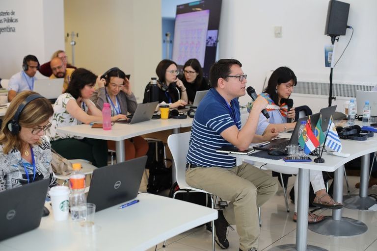
“NASA doesn’t just deliver data,” said John Bolten, NASA’s lead scientist for ISAT and chief of the Hydrological Sciences Laboratory at NASA’s Goddard Space Flight Center in Greenbelt, Maryland. “We collaborate with our partners and local experts to translate the data into information that is useful, usable, and relevant. That kind of coordination is what makes NASA’s water programs so effective on the ground, at home and around the world.”
The DINAGUA team brought ideas and provided guidelines to Pohren for a tool that applies Landsat and Sentinel satellite imagery to detect changes in Uruguay’s reservoirs. Landsat, a joint NASA-U.S. Geological Survey mission, provides decades of satellite imagery to track changes in land and water. The Sentinel missions, a part of the European Commission managed Copernicus Earth Observation program and operated by ESA (the European Space Agency), provide complementary visible, infrared, and microwave imagery for surface water assessments.
From a young age, Pohren was familiar with water-related challenges, as floods repeatedly inundated his relatives’ homes in his hometown of Montenegro, Brazil. It was extra motivation for him as he scoured ARSET tutorials and taught himself to write computer code. The result was a monitoring tool capable of estimating the surface area of Uruguay’s reservoirs over time.
A screenshot of the reservoir monitoring tool shows the Paso Severino’s surface water coverage alongside time-series data tracking its variations.Tiago Pohren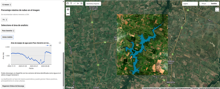
The tool draws on several techniques to differentiate the surface water extent of reservoirs. These techniques include three optical indicators derived from the Landsat 8 and Sentinel-2 satellites:
- Normalized Difference Water Index, which highlights water by comparing how much green and near-infrared light is reflected. Water absorbs infrared light, so it stands out clearly from land.
- Modified Normalized Difference Water Index, which swaps near-infrared with shortwave infrared to improve the contrast and reduce errors when differentiating between water and built-up or vegetated areas.
- Automated Water Extraction Index, which combines four types of reflected light — green, near-infrared, and two shortwave infrared bands — to help separate water from shadows and other dark features.
In 2023, the DINAGUA team used Pohren’s tool to examine reservoirs located upstream from Montevideo’s drinking water intake. But the data told a tough story.
“There was water available in other reservoirs, but it was a very small amount compared to the water demand of the Montevideo metropolitan region,” Pohren said. Simulations showed that even if all of the water were released, most of it would not reach the water intake for Montevideo or the Paso Severino reservoir.
Despite this news, the analysis prevented actions that might have wasted important resources for maintaining productive activities in the upper basin, Pohren said. Then, in August 2023, rain began to refill Uruguay’s reservoirs, allowing the country to declare an end to the water crisis.
From right to left: Tiago Pohren, Vanessa Erasun, and Florencia Hastings at the second ISAT workshop in March 2024.Organization of American States
Though the immediate water crisis has passed, the tool Pohren created will be useful in the future in Uruguay and around the world. During an ISAT workshop in 2024, he shared his tool with international water resources managers with the hope it could aid their own drought response efforts. And DINAGUA officials still use it to identify and monitor dams, irrigation reservoirs, and other water bodies in Uruguay.
Pohren continues to use NASA training and data to advance reservoir management. He’s currently exploring an ARSET training on how the Surface Water and Ocean Topography (SWOT) mission will further improve the system by allowing DINAGUA to directly measure the height of water in reservoirs. He is also following NASA’s new joint mission with ISRO (the Indian Space Research Organization) called NISAR, which launched on July 30. The NISAR satellite will provide radar data that detects changes in water extent, regardless of cloud cover or time of day. “If a drought happens again,” Pohren said, “with the tools that we have now, we will be much more prepared to understand what the conditions of the basin are and then make predictions.”
Environmental engineer Tiago Pohren conducts a field inspection on the Canelón Grande reservoir, the second-largest reservoir serving Montevideo, during the drought.Tiago Pohren
By Melody Pederson, Rachel Jiang
The authors would like to thank Noelia Gonzalez, Perry Oddo, Denise Hill, and Delfina Iervolino for interview support as well as Jerry Weigel for connecting with Tiago about the tool’s development.
Share Details Last Updated Sep 10, 2025 Related Terms Explore More 1 min read NASA’s Black Marble: Stories from the Night SkyStudying the glowing patterns of Earth’s surface helps us understand human activity, respond to disasters,…
Article 1 month ago 4 min read NUBE: New Card Game Helps Learners Identify Cloud Types Through Play Article 1 month ago 6 min read NASA’s TRACERS Studies Explosive Process in Earth’s Magnetic Shield Article 2 months ago Keep Exploring Discover More Topics From NASA EarthYour home. Our Mission. And the one planet that NASA studies more than any other.
Explore Earth Science
Earth Science in ActionNASA’s unique vantage point helps us inform solutions to enhance decision-making, improve livelihoods, and protect our planet.
Earth Multimedia & Galleries
Scientists find evidence of flowing water on Ryugu’s ancient parent asteroid. 'It was a genuine surprise!'
NASA Data, Trainings Help Uruguay Navigate Drought
- Earth
- Explore
- Science at Work
- Multimedia
- Data
- For Researchers
- About Us
NASA Earth Observatory/ Wanmei Liang
Lee esta historia en español aquí.
NASA satellite data and trainings helped Uruguay create a drought-response tool that its National Water Authority now uses to monitor reservoirs and guide emergency decisions. A similar approach could be applied in the United States and other countries around the world.
From 2018 to 2023, Uruguay experienced its worst drought in nearly a century. The capital city of Montevideo, home to nearly 2 million people, was especially hard hit. By mid-2023, Paso Severino, the largest reservoir and primary water source for Montevideo, had dropped to just 1.7% of its capacity. As water levels declined, government leaders declared an emergency. They began identifying backup supplies and asked: Was there water left in other upstream reservoirs — mainly used for livestock and irrigation — that could help?
That’s when environmental engineer Tiago Pohren and his colleagues at the National Water Authority (DINAGUA – Ministry of Environment) turned to NASA data and trainings to build an online tool that could help answer that question and improve monitoring of the nation’s reservoirs.
“Satellite data can inform everything from irrigation scheduling in the Great Plains to water quality management in the Chesapeake Bay,” said Erin Urquhart, manager of the water resources program at NASA Headquarters in Washington. “NASA provides the reliable data needed to respond to water crises anywhere in the world.”
Learning to Detect Water from SpaceThe DINAGUA team learned about NASA resources during a 2022 workshop in Buenos Aires, organized by the Interagency Science and Applications Team (ISAT). Led by NASA, the U.S. Army Corps of Engineers, and the U.S. Department of State, the workshop focused on developing tools to help manage water in the La Plata River Basin, which spans multiple South American countries including Uruguay.
At the workshop, researchers from NASA introduced participants to methods for measuring water resources from space. NASA’s Applied Remote Sensing (ARSET) program also provided a primer on remote sensing principles.
DINAGUA team supervisor Jose Rodolfo Valles León asks a question during a 2022 workshop in Buenos Aires. Other members of the Uruguay delegation — Florencia Hastings, Vanessa Erasun Rodríguez de Líma, Vanessa Ferreira, and Teresa Sastre (current Director of DINAGUA) — sit in the row behind. Organization of American States“NASA doesn’t just deliver data,” said John Bolten, NASA’s lead scientist for ISAT and chief of the Hydrological Sciences Laboratory at NASA’s Goddard Space Flight Center in Greenbelt, Maryland. “We collaborate with our partners and local experts to translate the data into information that is useful, usable, and relevant. That kind of coordination is what makes NASA’s water programs so effective on the ground, at home and around the world.”
The DINAGUA team brought ideas and provided guidelines to Pohren for a tool that applies Landsat and Sentinel satellite imagery to detect changes in Uruguay’s reservoirs. Landsat, a joint NASA-U.S. Geological Survey mission, provides decades of satellite imagery to track changes in land and water. The Sentinel missions, a part of the European Commission managed Copernicus Earth Observation program and operated by ESA (the European Space Agency), provide complementary visible, infrared, and microwave imagery for surface water assessments.
From a young age, Pohren was familiar with water-related challenges, as floods repeatedly inundated his relatives’ homes in his hometown of Montenegro, Brazil. It was extra motivation for him as he scoured ARSET tutorials and taught himself to write computer code. The result was a monitoring tool capable of estimating the surface area of Uruguay’s reservoirs over time.
A screenshot of the reservoir monitoring tool shows the Paso Severino’s surface water coverage alongside time-series data tracking its variations. Tiago PohrenThe tool draws on several techniques to differentiate the surface water extent of reservoirs. These techniques include three optical indicators derived from the Landsat 8 and Sentinel-2 satellites:
- Normalized Difference Water Index, which highlights water by comparing how much green and near-infrared light is reflected. Water absorbs infrared light, so it stands out clearly from land.
- Modified Normalized Difference Water Index, which swaps near-infrared with shortwave infrared to improve the contrast and reduce errors when differentiating between water and built-up or vegetated areas.
- Automated Water Extraction Index, which combines four types of reflected light — green, near-infrared, and two shortwave infrared bands — to help separate water from shadows and other dark features.
In 2023, the DINAGUA team used Pohren’s tool to examine reservoirs located upstream from Montevideo’s drinking water intake. But the data told a tough story.
“There was water available in other reservoirs, but it was a very small amount compared to the water demand of the Montevideo metropolitan region,” Pohren said. Simulations showed that even if all of the water were released, most of it would not reach the water intake for Montevideo or the Paso Severino reservoir.
Despite this news, the analysis prevented actions that might have wasted important resources for maintaining productive activities in the upper basin, Pohren said. Then, in August 2023, rain began to refill Uruguay’s reservoirs, allowing the country to declare an end to the water crisis.
From right to left: Tiago Pohren, Vanessa Erasun, and Florencia Hastings at the second ISAT workshop in March 2024. Organization of American StatesThough the immediate water crisis has passed, the tool Pohren created will be useful in the future in Uruguay and around the world. During an ISAT workshop in 2024, he shared his tool with international water resources managers with the hope it could aid their own drought response efforts. And DINAGUA officials still use it to identify and monitor dams, irrigation reservoirs, and other water bodies in Uruguay.
Pohren continues to use NASA training and data to advance reservoir management. He’s currently exploring an ARSET training on how the Surface Water and Ocean Topography (SWOT) mission will further improve the system by allowing DINAGUA to directly measure the height of water in reservoirs. He is also following NASA’s new joint mission with ISRO (the Indian Space Research Organization) called NISAR, which launched on July 30. The NISAR satellite will provide radar data that detects changes in water extent, regardless of cloud cover or time of day. “If a drought happens again,” Pohren said, “with the tools that we have now, we will be much more prepared to understand what the conditions of the basin are and then make predictions.”
Environmental engineer Tiago Pohren conducts a field inspection on the Canelón Grande reservoir, the second-largest reservoir serving Montevideo, during the drought. Tiago PohrenBy Melody Pederson, Rachel Jiang
The authors would like to thank Noelia Gonzalez, Perry Oddo, Denise Hill, and Delfina Iervolino for interview support as well as Jerry Weigel for connecting with Tiago about the tool’s development.
Share Details Last Updated Sep 10, 2025 Related Terms Explore More 1 min read NASA’s Black Marble: Stories from the Night SkyStudying the glowing patterns of Earth’s surface helps us understand human activity, respond to disasters,…
Article
1 month ago
4 min read NUBE: New Card Game Helps Learners Identify Cloud Types Through Play
Article
1 month ago
6 min read NASA’s TRACERS Studies Explosive Process in Earth’s Magnetic Shield
Article
2 months ago
Keep Exploring Discover More Topics From NASA Earth
Your home. Our Mission. And the one planet that NASA studies more than any other.
Explore Earth Science
Earth Science in Action
NASA’s unique vantage point helps us inform solutions to enhance decision-making, improve livelihoods, and protect our planet.
Earth Multimedia & Galleries
We evolved to match local micronutrient levels, which may be a problem
We evolved to match local micronutrient levels, which may be a problem
Gravitational waves finally prove Stephen Hawking's black hole theorem
Gravitational waves finally prove Stephen Hawking's black hole theorem
NASA hasn't found life on Mars yet – but signs are promising
NASA hasn't found life on Mars yet – but signs are promising
Which perimenopause treatments actually work?
Which perimenopause treatments actually work?
Tiny structure in the brain could be driving how much you eat
Tiny structure in the brain could be driving how much you eat
Asteroid Ryugu once had liquid water flowing through it
Asteroid Ryugu once had liquid water flowing through it
Can we safely deflect a killer asteroid without making it worse? Only if we avoid the gravitational 'keyhole,' scientists say
NASA Says Mars Rover Discovered Potential Biosignature Last Year
Lee este comunicado de prensa en español aquí.
A sample collected by NASA’s Perseverance Mars rover from an ancient dry riverbed in Jezero Crater could preserve evidence of ancient microbial life. Taken from a rock named “Cheyava Falls” last year, the sample, called “Sapphire Canyon,” contains potential biosignatures, according to a paper published Wednesday in the journal Nature.
A potential biosignature is a substance or structure that might have a biological origin but requires more data or further study before a conclusion can be reached about the absence or presence of life.
“This finding by Perseverance, launched under President Trump in his first term, is the closest we have ever come to discovering life on Mars. The identification of a potential biosignature on the Red Planet is a groundbreaking discovery, and one that will advance our understanding of Mars,” said acting NASA Administrator Sean Duffy. “NASA’s commitment to conducting Gold Standard Science will continue as we pursue our goal of putting American boots on Mars’ rocky soil.”
NASA’s Perseverance rover discovered leopard spots on a reddish rock nicknamed “Cheyava Falls” in Mars’ Jezero Crater in July 2024. Scientists think the spots may indicate that, billions of years ago, the chemical reactions in this rock could have supported microbial life; other explanations are being considered.Credit: NASA/JPL-Caltech/MSSS NASA’s Perseverance Mars rover took this selfie, made up of 62 individual images, on July 23, 2024. A rock nicknamed “Cheyava Falls,” which has features that may bear on the question of whether the Red Planet was long ago home to microscopic life, is to the left of the rover near the center of the image.Credit: NASA/JPL-Caltech/MSSSPerseverance came upon Cheyava Falls in July 2024 while exploring the “Bright Angel” formation, a set of rocky outcrops on the northern and southern edges of Neretva Vallis, an ancient river valley measuring a quarter-mile (400 meters) wide that was carved by water rushing into Jezero Crater long ago.
“This finding is the direct result of NASA’s effort to strategically plan, develop, and execute a mission able to deliver exactly this type of science — the identification of a potential biosignature on Mars,” said Nicky Fox, associate administrator, Science Mission Directorate at NASA Headquarters in Washington. “With the publication of this peer-reviewed result, NASA makes this data available to the wider science community for further study to confirm or refute its biological potential.”
The rover’s science instruments found that the formation’s sedimentary rocks are composed of clay and silt, which, on Earth, are excellent preservers of past microbial life. They also are rich in organic carbon, sulfur, oxidized iron (rust), and phosphorous.
“The combination of chemical compounds we found in the Bright Angel formation could have been a rich source of energy for microbial metabolisms,” said Perseverance scientist Joel Hurowitz of Stony Brook University, New York and lead author of the paper. “But just because we saw all these compelling chemical signatures in the data didn’t mean we had a potential biosignature. We needed to analyze what that data could mean.”
First to collect data on this rock were Perseverance’s PIXL (Planetary Instrument for X-ray Lithochemistry) and SHERLOC (Scanning Habitable Environments with Raman & Luminescence for Organics & Chemicals) instruments. While investigating Cheyava Falls, an arrowhead-shaped rock measuring 3.2 feet by 2 feet (1 meter by 0.6 meters), they found what appeared to be colorful spots. The spots on the rock could have been left behind by microbial life if it had used the raw ingredients, the organic carbon, sulfur, and phosphorus, in the rock as an energy source.
In higher-resolution images, the instruments found a distinct pattern of minerals arranged into reaction fronts (points of contact where chemical and physical reactions occur) the team called leopard spots. The spots carried the signature of two iron-rich minerals: vivianite (hydrated iron phosphate) and greigite (iron sulfide). Vivianite is frequently found on Earth in sediments, peat bogs, and around decaying organic matter. Similarly, certain forms of microbial life on Earth can produce greigite.
The combination of these minerals, which appear to have formed by electron-transfer reactions between the sediment and organic matter, is a potential fingerprint for microbial life, which would use these reactions to produce energy for growth. The minerals also can be generated abiotically, or without the presence of life. Hence, there are ways to produce them without biological reactions, including sustained high temperatures, acidic conditions, and binding by organic compounds. However, the rocks at Bright Angel do not show evidence that they experienced high temperatures or acidic conditions, and it is unknown whether the organic compounds present would’ve been capable of catalyzing the reaction at low temperatures.
The discovery was particularly surprising because it involves some of the youngest sedimentary rocks the mission has investigated. An earlier hypothesis assumed signs of ancient life would be confined to older rock formations. This finding suggests that Mars could have been habitable for a longer period or later in the planet’s history than previously thought, and that older rocks also might hold signs of life that are simply harder to detect.
“Astrobiological claims, particularly those related to the potential discovery of past extraterrestrial life, require extraordinary evidence,” said Katie Stack Morgan, Perseverance’s project scientist at NASA’s Jet Propulsion Laboratory in Southern California. “Getting such a significant finding as a potential biosignature on Mars into a peer-reviewed publication is a crucial step in the scientific process because it ensures the rigor, validity, and significance of our results. And while abiotic explanations for what we see at Bright Angel are less likely given the paper’s findings, we cannot rule them out.”
The scientific community uses tools and frameworks like the CoLD scale and Standards of Evidence to assess whether data related to the search for life actually answers the question, Are we alone? Such tools help improve understanding of how much confidence to place in data suggesting a possible signal of life found outside our own planet.
Marked by seven benchmarks, the Confidence of Life Detection, or CoLD, scale outlines a progression in confidence that a set of observations stands as evidence of life. Credit: NASA
Sapphire Canyon is one of 27 rock cores the rover has collected since landing at Jezero Crater in February 2021. Among the suite of science instruments is a weather station that provides environmental information for future human missions, as well as swatches of spacesuit material so that NASA can study how it fares on Mars.
Managed for NASA by Caltech, NASA JPL built and manages operations of the Perseverance rover on behalf of the agency’s Science Mission Directorate as part of NASA’s Mars Exploration Program portfolio.
To learn more about Perseverance visit:
https://science.nasa.gov/mission/mars-2020-perseverance
-end-
Bethany Stevens / Karen Fox
Headquarters, Washington
202-358-1600
bethany.c.stevens@nasa.gov / karen.c.fox@nasa.gov
DC Agle
Jet Propulsion Laboratory, Pasadena, Calif.
818-393-9011
agle@jpl.nasa.gov