
Feed aggregator
NASA Invites Media to Learn About New Missions to Map Sun’s Influence
NASA will hold a media teleconference at 12 p.m. EDT on Thursday, Sept. 4, to discuss the agency’s upcoming Sun and space weather missions, IMAP (Interstellar Mapping and Acceleration Probe) and Carruthers Geocorona Observatory. The two missions are targeting launch on the same rocket no earlier than Tuesday, Sept. 23.
The IMAP mission will map the boundaries of our heliosphere, the vast bubble created by the Sun’s wind that encapsulates our entire solar system. As a modern-day celestial cartographer, IMAP will explore how the heliosphere interacts with interstellar space, as well as chart the range of particles that fill the space between the planets. The IMAP mission also will support near real-time observations of the solar wind and energetic particles. These energetic particles can produce hazardous space weather that can impact spacecraft and other NASA hardware as the agency explores deeper into space, including at the Moon under the Artemis campaign.
NASA’s Carruthers Geocorona Observatory will image the ultraviolet glow of Earth’s exosphere, the outermost region of our planet’s atmosphere. This data will help scientists understand how space weather from the Sun shapes the exosphere and ultimately impacts our planet. The first observation of this glow – called the geocorona – was captured during Apollo 16, when a telescope designed and built by George Carruthers was deployed on the Moon.
Audio of the teleconference will stream live on the agency’s website at:
Participants include:
- Nicky Fox, associate administrator, Science Mission Directorate, NASA Headquarters in Washington
- Teresa Nieves-Chinchilla, director, Moon to Mars Space Weather Analysis Office, NASA’s Goddard Space Flight Center in Greenbelt, Maryland
- David J. McComas, IMAP principal investigator, Princeton University
- Lara Waldrop, Carruthers Geocorona Observatory principal investigator, University of Illinois Urbana-Champaign
To participate in the media teleconference, media must RSVP no later than 11 a.m. on Sept. 4 to Sarah Frazier at: sarah.frazier@nasa.gov. NASA’s media accreditation policy is available online.
The IMAP and Carruthers Geocorona Observatory missions will launch on a SpaceX Falcon 9 rocket from Launch Complex 39A at NASA’s Kennedy Space Center in Florida. Also launching on this flight will be the National Oceanic and Atmospheric Administration’s (NOAA) Space Weather Follow On – Lagrange 1 (SWFO-L1), which will monitor solar wind disturbances and detect and track coronal mass ejections before they reach Earth.
David McComas, professor, Princeton University, leads the IMAP mission with an international team of 27 partner institutions. The Johns Hopkins Applied Physics Laboratory in Laurel, Maryland, built the spacecraft and will operate the mission. NASA’s IMAP is the fifth mission in NASA’s Solar Terrestrial Probes Program portfolio.
The Carruthers Geocorona Observatory mission is led by Lara Waldrop from the University of Illinois Urbana-Champaign. Mission implementation is led by the Space Sciences Laboratory at University of California, Berkeley, which also designed and built the two ultraviolet imagers. BAE Systems designed and built the Carruthers spacecraft.
The Solar Terrestrial Probes Program Office, part of the Explorers and Heliophysics Project Division at NASA Goddard, manages the IMAP and Carruthers Geocorona Observatory missions for NASA’s Science Mission Directorate.
NASA’s Launch Services Program, based at NASA Kennedy, manages the launch service for the mission.
To learn more about IMAP, please visit:
-end-
Abbey Interrante / Karen Fox
Headquarters, Washington
301-201-0124 / 202-358-1600
abbey.a.interrante@nasa.gov / karen.c.fox@nasa.gov
Sarah Frazier
Goddard Space Flight Center, Greenbelt, Md.
202-853-7191
sarah.frazier@nasa.gov
Could Exoplanets Help in the Search for Dark Matter?
According to a recent study by a team from the University of California, Riverside, exoplanets could be used by astronomers to investigate Dark Matter - the mysterious mass that makes up 85% of matter in the Universe.
The Great Filter Part 2: We’ve Made It Through
Now versions of the Great Filter argument had been around for decades (just like Fermi was not the first person to ask where everybody is), but the most comprehensive form of the argument comes from Robin Hanson in 1996.
Researchers Pinpoint A Non-Repeating FRB To Within A Few Light Years
Fast radio bursts (FRBs) are some of the most powerful signals in the universe. They can emit as much power in a few milliseconds as our Sun does in several days. Despite their strength, we still don’t have a definitive answer to what causes them. That is partly because, at least for the ones that only happen once, they are really hard to point down. But a new extension to the Canadian Hydrogen Intensity Mapping Experiment (CHIME) might provide the resolution needed to determine where non-repeating FRBs come from - and its first discovery was one of the brightest FRBs of all time, which helped researchers track it with an unprecedented level of precision, as described in a new paper in The Astrophysical Journal Letters.
'We need to broaden our search, and now we can.' Scientists are set to unleash a powerful new weapon in the hunt for dark matter
Fast Radio Burst's Neighborhood Revealed
Astronomers have pinpointed the location of an one-time fast radio burst to a spiral arm of a nearby galaxy.
The post Fast Radio Burst's Neighborhood Revealed appeared first on Sky & Telescope.
NASA Marsquake Data Reveals Lumpy Nature of Red Planet’s Interior
6 min read
Preparations for Next Moonwalk Simulations Underway (and Underwater) Scientists believe giant impacts — like the one depicted in this artist’s concept — occurred on Mars 4.5 billion years ago, injecting debris from the impact deep into the planet’s mantle. NASA’s InSight lander detected this debris before the mission’s end in 2022.NASA/JPL-Caltech
Rocky material that impacted Mars lies scattered in giant lumps throughout the planet’s mantle, offering clues about Mars’ interior and its ancient past.
What appear to be fragments from the aftermath of massive impacts on Mars that occurred 4.5 billion years ago have been detected deep below the planet’s surface. The discovery was made thanks to NASA’s now-retired InSight lander, which recorded the findings before the mission’s end in 2022. The ancient impacts released enough energy to melt continent-size swaths of the early crust and mantle into vast magma oceans, simultaneously injecting the impactor fragments and Martian debris deep into the planet’s interior.
There’s no way to tell exactly what struck Mars: The early solar system was filled with a range of different rocky objects that could have done so, including some so large they were effectively protoplanets. The remains of these impacts still exist in the form of lumps that are as large as 2.5 miles (4 kilometers) across and scattered throughout the Martian mantle. They offer a record preserved only on worlds like Mars, whose lack of tectonic plates has kept its interior from being churned up the way Earth’s is through a process known as convection.
A cutaway view of Mars in this artist’s concept (not to scale) reveals debris from ancient impacts scattered through the planet’s mantle. On the surface at left, a meteoroid impact sends seismic signals through the interior; at right is NASA’s InSight lander.NASA/JPL-Caltech
The finding was reported Thursday, Aug. 28, in a study published by the journal Science.
“We’ve never seen the inside of a planet in such fine detail and clarity before,” said the paper’s lead author, Constantinos Charalambous of Imperial College London. “What we’re seeing is a mantle studded with ancient fragments. Their survival to this day tells us Mars’ mantle has evolved sluggishly over billions of years. On Earth, features like these may well have been largely erased.”
InSight, which was managed by NASA’s Jet Propulsion Laboratory in Southern California, placed the first seismometer on Mars’ surface in 2018. The extremely sensitive instrument recorded 1,319 marsquakes before the lander’s end of mission in 2022.
NASA’s InSight took this selfie in 2019 using a camera on its robotic arm. The lander also used its arm to deploy the mission’s seismometer, whose data was used in a 2025 study showing impacts left chunks of debris deep in the planet’s interior.NASA/JPL-Caltech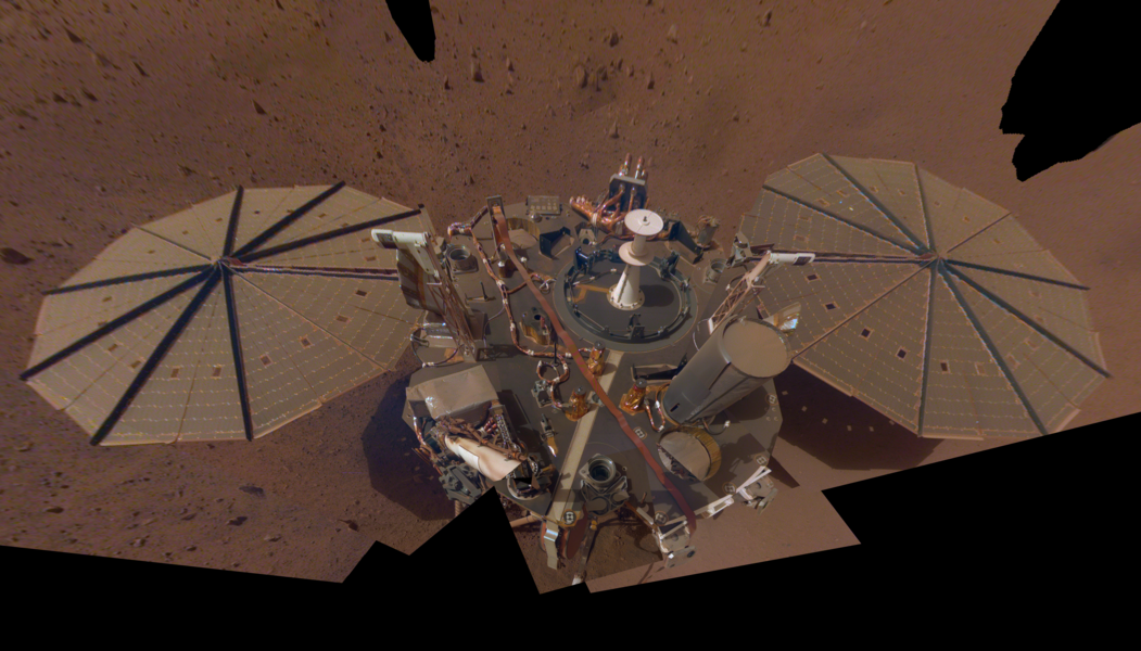
Quakes produce seismic waves that change as they pass through different kinds of material, providing scientists a way to study the interior of a planetary body. To date, the InSight team has measured the size, depth, and composition of Mars’ crust, mantle, and core. This latest discovery regarding the mantle’s composition suggests how much is still waiting to be discovered within InSight’s data.
“We knew Mars was a time capsule bearing records of its early formation, but we didn’t anticipate just how clearly we’d be able to see with InSight,” said Tom Pike of Imperial College London, coauthor of the paper.
Quake huntingMars lacks the tectonic plates that produce the temblors many people in seismically active areas are familiar with. But there are two other types of quakes on Earth that also occur on Mars: those caused by rocks cracking under heat and pressure, and those caused by meteoroid impacts.
Of the two types, meteoroid impacts on Mars produce high-frequency seismic waves that travel from the crust deep into the planet’s mantle, according to a paper published earlier this year in Geophysical Research Letters. Located beneath the planet’s crust, the Martian mantle can be as much as 960 miles (1,550 kilometers) thick and is made of solid rock that can reach temperatures as high as 2,732 degrees Fahrenheit (1,500 degrees Celsius).
Scrambled signalsThe new Science paper identifies eight marsquakes whose seismic waves contained strong, high-frequency energy that reached deep into the mantle, where their seismic waves were distinctly altered.
“When we first saw this in our quake data, we thought the slowdowns were happening in the Martian crust,” Pike said. “But then we noticed that the farther seismic waves travel through the mantle, the more these high-frequency signals were being delayed.”
Using planetwide computer simulations, the team saw that the slowing down and scrambling happened only when the signals passed through small, localized regions within the mantle. They also determined that these regions appear to be lumps of material with a different composition than the surrounding mantle.
With one riddle solved, the team focused on another: how those lumps got there.
Turning back the clock, they concluded that the lumps likely arrived as giant asteroids or other rocky material that struck Mars during the early solar system, generating those oceans of magma as they drove deep into the mantle, bringing with them fragments of crust and mantle.
Charalambous likens the pattern to shattered glass — a few large shards with many smaller fragments. The pattern is consistent with a large release of energy that scattered many fragments of material throughout the mantle. It also fits well with current thinking that in the early solar system, asteroids and other planetary bodies regularly bombarded the young planets.
On Earth, the crust and uppermost mantle is continuously recycled by plate tectonics pushing a plate’s edge into the hot interior, where, through convection, hotter, less-dense material rises and cooler, denser material sinks. Mars, by contrast, lacks tectonic plates, and its interior circulates far more sluggishly. The fact that such fine structures are still visible today, Charalambous said, “tells us Mars hasn’t undergone the vigorous churning that would have smoothed out these lumps.”
And in that way, Mars could point to what may be lurking beneath the surface of other rocky planets that lack plate tectonics, including Venus and Mercury.
More about InSightJPL managed InSight for NASA’s Science Mission Directorate. InSight was part of NASA’s Discovery Program, managed by the agency’s Marshall Space Flight Center in Huntsville, Alabama. Lockheed Martin Space in Denver built the InSight spacecraft, including its cruise stage and lander, and supported spacecraft operations for the mission.
A number of European partners, including France’s Centre National d’Études Spatiales (CNES) and the German Aerospace Center (DLR), supported the InSight mission. CNES provided the Seismic Experiment for Interior Structure (SEIS) instrument to NASA, with the principal investigator at IPGP (Institut de Physique du Globe de Paris). Significant contributions for SEIS came from IPGP; the Max Planck Institute for Solar System Research (MPS) in Germany; the Swiss Federal Institute of Technology (ETH Zurich) in Switzerland; Imperial College London and Oxford University in the United Kingdom; and JPL. DLR provided the Heat Flow and Physical Properties Package (HP3) instrument, with significant contributions from the Space Research Center (CBK) of the Polish Academy of Sciences and Astronika in Poland. Spain’s Centro de Astrobiología (CAB) supplied the temperature and wind sensors.
News Media ContactsAndrew Good
Jet Propulsion Laboratory, Pasadena, Calif.
818-393-2433
andrew.c.good@jpl.nasa.gov
Karen Fox / Molly Wasser
NASA Headquarters, Washington
202-358-1600
karen.c.fox@nasa.gov / molly.l.wasser@nasa.gov
2025-110
Share Details Last Updated Aug 28, 2025 Related Terms Explore More 4 min read NASA: Ceres May Have Had Long-Standing Energy to Fuel Habitability Article 1 week ago 4 min read NASA’s Psyche Captures Images of Earth, Moon Article 1 week ago 4 min read US-French SWOT Satellite Measures Tsunami After Massive Quake Article 3 weeks ago Keep Exploring Discover Related TopicsMissions
Humans in Space
Climate Change
Solar System
NASA Marsquake Data Reveals Lumpy Nature of Red Planet’s Interior
6 min read
Preparations for Next Moonwalk Simulations Underway (and Underwater) Scientists believe giant impacts — like the one depicted in this artist’s concept — occurred on Mars 4.5 billion years ago, injecting debris from the impact deep into the planet’s mantle. NASA’s InSight lander detected this debris before the mission’s end in 2022.NASA/JPL-CaltechRocky material that impacted Mars lies scattered in giant lumps throughout the planet’s mantle, offering clues about Mars’ interior and its ancient past.
What appear to be fragments from the aftermath of massive impacts on Mars that occurred 4.5 billion years ago have been detected deep below the planet’s surface. The discovery was made thanks to NASA’s now-retired InSight lander, which recorded the findings before the mission’s end in 2022. The ancient impacts released enough energy to melt continent-size swaths of the early crust and mantle into vast magma oceans, simultaneously injecting the impactor fragments and Martian debris deep into the planet’s interior.
There’s no way to tell exactly what struck Mars: The early solar system was filled with a range of different rocky objects that could have done so, including some so large they were effectively protoplanets. The remains of these impacts still exist in the form of lumps that are as large as 2.5 miles (4 kilometers) across and scattered throughout the Martian mantle. They offer a record preserved only on worlds like Mars, whose lack of tectonic plates has kept its interior from being churned up the way Earth’s is through a process known as convection.
A cutaway view of Mars in this artist’s concept (not to scale) reveals debris from ancient impacts scattered through the planet’s mantle. On the surface at left, a meteoroid impact sends seismic signals through the interior; at right is NASA’s InSight lander.NASA/JPL-CaltechThe finding was reported Thursday, Aug. 28, in a study published by the journal Science.
“We’ve never seen the inside of a planet in such fine detail and clarity before,” said the paper’s lead author, Constantinos Charalambous of Imperial College London. “What we’re seeing is a mantle studded with ancient fragments. Their survival to this day tells us Mars’ mantle has evolved sluggishly over billions of years. On Earth, features like these may well have been largely erased.”
InSight, which was managed by NASA’s Jet Propulsion Laboratory in Southern California, placed the first seismometer on Mars’ surface in 2018. The extremely sensitive instrument recorded 1,319 marsquakes before the lander’s end of mission in 2022.
NASA’s InSight took this selfie in 2019 using a camera on its robotic arm. The lander also used its arm to deploy the mission’s seismometer, whose data was used in a 2025 study showing impacts left chunks of debris deep in the planet’s interior.NASA/JPL-CaltechQuakes produce seismic waves that change as they pass through different kinds of material, providing scientists a way to study the interior of a planetary body. To date, the InSight team has measured the size, depth, and composition of Mars’ crust, mantle, and core. This latest discovery regarding the mantle’s composition suggests how much is still waiting to be discovered within InSight’s data.
“We knew Mars was a time capsule bearing records of its early formation, but we didn’t anticipate just how clearly we’d be able to see with InSight,” said Tom Pike of Imperial College London, coauthor of the paper.
Quake huntingMars lacks the tectonic plates that produce the temblors many people in seismically active areas are familiar with. But there are two other types of quakes on Earth that also occur on Mars: those caused by rocks cracking under heat and pressure, and those caused by meteoroid impacts.
Of the two types, meteoroid impacts on Mars produce high-frequency seismic waves that travel from the crust deep into the planet’s mantle, according to a paper published earlier this year in Geophysical Research Letters. Located beneath the planet’s crust, the Martian mantle can be as much as 960 miles (1,550 kilometers) thick and is made of solid rock that can reach temperatures as high as 2,732 degrees Fahrenheit (1,500 degrees Celsius).
Scrambled signalsThe new Science paper identifies eight marsquakes whose seismic waves contained strong, high-frequency energy that reached deep into the mantle, where their seismic waves were distinctly altered.
“When we first saw this in our quake data, we thought the slowdowns were happening in the Martian crust,” Pike said. “But then we noticed that the farther seismic waves travel through the mantle, the more these high-frequency signals were being delayed.”
Using planetwide computer simulations, the team saw that the slowing down and scrambling happened only when the signals passed through small, localized regions within the mantle. They also determined that these regions appear to be lumps of material with a different composition than the surrounding mantle.
With one riddle solved, the team focused on another: how those lumps got there.
Turning back the clock, they concluded that the lumps likely arrived as giant asteroids or other rocky material that struck Mars during the early solar system, generating those oceans of magma as they drove deep into the mantle, bringing with them fragments of crust and mantle.
Charalambous likens the pattern to shattered glass — a few large shards with many smaller fragments. The pattern is consistent with a large release of energy that scattered many fragments of material throughout the mantle. It also fits well with current thinking that in the early solar system, asteroids and other planetary bodies regularly bombarded the young planets.
On Earth, the crust and uppermost mantle is continuously recycled by plate tectonics pushing a plate’s edge into the hot interior, where, through convection, hotter, less-dense material rises and cooler, denser material sinks. Mars, by contrast, lacks tectonic plates, and its interior circulates far more sluggishly. The fact that such fine structures are still visible today, Charalambous said, “tells us Mars hasn’t undergone the vigorous churning that would have smoothed out these lumps.”
And in that way, Mars could point to what may be lurking beneath the surface of other rocky planets that lack plate tectonics, including Venus and Mercury.
More about InSightJPL managed InSight for NASA’s Science Mission Directorate. InSight was part of NASA’s Discovery Program, managed by the agency’s Marshall Space Flight Center in Huntsville, Alabama. Lockheed Martin Space in Denver built the InSight spacecraft, including its cruise stage and lander, and supported spacecraft operations for the mission.
A number of European partners, including France’s Centre National d’Études Spatiales (CNES) and the German Aerospace Center (DLR), supported the InSight mission. CNES provided the Seismic Experiment for Interior Structure (SEIS) instrument to NASA, with the principal investigator at IPGP (Institut de Physique du Globe de Paris). Significant contributions for SEIS came from IPGP; the Max Planck Institute for Solar System Research (MPS) in Germany; the Swiss Federal Institute of Technology (ETH Zurich) in Switzerland; Imperial College London and Oxford University in the United Kingdom; and JPL. DLR provided the Heat Flow and Physical Properties Package (HP3) instrument, with significant contributions from the Space Research Center (CBK) of the Polish Academy of Sciences and Astronika in Poland. Spain’s Centro de Astrobiología (CAB) supplied the temperature and wind sensors.
News Media ContactsAndrew Good
Jet Propulsion Laboratory, Pasadena, Calif.
818-393-2433
andrew.c.good@jpl.nasa.gov
Karen Fox / Molly Wasser
NASA Headquarters, Washington
202-358-1600
karen.c.fox@nasa.gov / molly.l.wasser@nasa.gov
2025-110
Share Details Last Updated Aug 28, 2025 Related Terms Explore More 4 min read NASA: Ceres May Have Had Long-Standing Energy to Fuel Habitability Article 2 weeks ago 4 min read NASA’s Psyche Captures Images of Earth, Moon Article 2 weeks ago 4 min read US-French SWOT Satellite Measures Tsunami After Massive Quake Article 4 weeks ago Keep Exploring Discover Related TopicsMissions
Humans in Space
Climate Change
Solar System
Don't miss the stars of the 'Summer Triangle' twinkle with the Milky Way after sunset
NASA, International Astronauts to Address Students from New York
NASA astronaut Jonny Kim and JAXA (Japan Aerospace Exploration Agency) astronaut Kimiya Yui will connect with students in New York as they answer prerecorded science, technology, engineering, and mathematics (STEM) questions aboard the International Space Station.
The Earth-to-space call will begin at 9:20 a.m. EDT on Friday, Sept. 5, and will stream live on the agency’s Learn With NASA YouTube channel.
Media interested in covering the event must RSVP by 5 p.m. Wednesday, Sept. 3, to Sara Sloves at: 917-441-1234 or ssloves@thecomputerschool.org.
The Computer School will host this event in New York for middle school students. The goal of this event is to extend learning by exposing students to the real-world experiences and engineering challenges of astronauts working and living aboard the International Space Station.
For nearly 25 years, astronauts have continuously lived and worked aboard the space station, testing technologies, performing science, and developing skills needed to explore farther from Earth. Astronauts communicate with NASA’s Mission Control Center in Houston 24 hours a day through SCaN’s (Space Communications and Navigation) Near Space Network.
Research and technology investigations taking place aboard the space station benefit people on Earth and lay the groundwork for other agency deep space missions. As part of NASA’s Artemis campaign, the agency will send astronauts to the Moon to prepare for future human exploration of Mars, inspiring the world through discovery in a new Golden Age of innovation and exploration.
See more information on NASA in-flight calls at:
https://www.nasa.gov/stemonstation
-end-
Gerelle Dodson
Headquarters, Washington
202-358-1600
gerelle.q.dodson@nasa.gov
Sandra Jones
Johnson Space Center, Houston
281-483-5111
sandra.p.jones@nasa.gov
NASA Scientists Help Maryland County Plan to Beat Summer Heat Risks
4 min read
Preparations for Next Moonwalk Simulations Underway (and Underwater) These maps of Prince George’s County, MD, show surface temperatures collected a few hours apart on July 30, 2023 from the Landsat 9 satellite and the ECOsystem Spaceborne Thermal Radiometer Experiment on Space Station (ECOSTRESS) instrument. The dark blue spots in the right hand image are likely clouds that formed in the afternoon.Credit: Stephanie Schollaert Uz, NASA Goddard Space Flight Center
Thousands of Americans are impacted each summer by excessive heat and humidity, some suffering from heat-related illnesses when the body can’t cool itself down. Data from NASA satellites could help local governments reduce the sweltering risks, thanks to a collaboration between NASA scientists and officials in Prince George’s County, Maryland. The effort demonstrates how local officials in other communities could turn to NASA data to inform decisions that provide residents with relief from summer heat.
NASA researchers and their Prince George’s County collaborators reported in Frontiers in Environmental Science that they used the Landsat 8 satellite, jointly operated by NASA and the US Geological Survey, and NASA’s Aqua satellite, to gain insight into surface temperature trends across the county over the past few decades. The data also show how temperatures have responded to changing land use and construction. It is information that county planners and environmental experts hope can aid them in their attempts to remediate and prevent heat dangers in the future. The collaboration may also help the county’s first responders anticipate and prepare for heat-related emergencies and injuries.
Cooperation with Prince George’s County expands on NASA’s historic role, said Stephanie Schollaert Uz, an applications scientist with NASA’s Goddard Space Flight Center in Greenbelt, Maryland, and one of the study authors. “Applying government satellite data to county-level problems is new here. We’re trying to make it easier for people outside of NASA to use our data, in part by including how-to guides referenced at the end of our paper,” Schollaert Uz said.
In the long run, county officials hope to use NASA satellites to track the negative health impacts that arise from land use and modification. Removal of tree cover and the construction of non-permeable roads, parking lots, and structures that lead to water runoff are among the factors that create heat islands, where temperatures in localized areas soar relative to the surrounding landscape. In addition to the direct dangers of heat for county residents and workers, areas with higher-than-normal temperatures can drive intense local weather events.
“There’s potentially a greater incidence of microbursts,” said Mary Abe of Prince George’s County’s sustainability division. “The atmosphere can become supercharged over hot spots,” causing high winds and flood-inducing rains.
Prince George’s County planners anticipate relying on NASA satellites to determine where residents and county employees are at greater risk, predict how future construction could impact heat dangers, and develop strategies to moderate heat in areas currently experiencing elevated summer temperatures. Efforts might include protecting existing trees and planting new ones. It could include replacing impermeable surfaces (cement, pavement, etc.) with alternatives that let water soak into the ground rather than running off into storm drains. To verify and calibrate the satellite observations crucial for such planning, county experts are considering enlisting residents to act as citizen scientists to collect temperature and weather data on the ground, Abe said.
Eventually, the NASA satellite temperature data could also lead to strategies to curb insect-borne diseases, said Evelyn Hoban, associate director for the Prince George’s County division of environmental health and communicable disease. “Once we know where the higher temperatures are, we can check to see if they create mosquito or tick breeding grounds,” said Hoban, who coauthored the study. “We could then focus our outreach and education, and perhaps prevention efforts, on areas of greater heat and risk.”
A NASA guide is available to aid other communities who hope to duplicate the Prince George’s County study. The guide provides introductions on a variety of NASA satellite and ground-based weather station data. Instructions for downloading and analyzing the data are illustrated in an accompanying tutorial that uses the Prince George’s County study as an example for other communities to follow on their own.
One of the greatest benefits of the collaboration, Abe said, is the boost in credibility that comes from incorporating NASA resources and expertise in the county’s efforts to improve safety and health. “It’s partly the NASA brand. People recognize it and they’re really intrigued by it,” she said. “Working with NASA builds confidence that the decision-making process is based firmly in science.”
By James Riordon
NASA Goddard Space Flight Center
Media contact: Elizabeth Vlock
NASA Headquarters
Missions
Humans in Space
Climate Change
Solar System
NASA Scientists Help Maryland County Plan to Beat Summer Heat Risks
4 min read
Preparations for Next Moonwalk Simulations Underway (and Underwater) These maps of Prince George’s County, MD, show surface temperatures collected a few hours apart on July 30, 2023 from the Landsat 9 satellite and the ECOsystem Spaceborne Thermal Radiometer Experiment on Space Station (ECOSTRESS) instrument. The dark blue spots in the right hand image are likely clouds that formed in the afternoon.Credit: Stephanie Schollaert Uz, NASA Goddard Space Flight CenterThousands of Americans are impacted each summer by excessive heat and humidity, some suffering from heat-related illnesses when the body can’t cool itself down. Data from NASA satellites could help local governments reduce the sweltering risks, thanks to a collaboration between NASA scientists and officials in Prince George’s County, Maryland. The effort demonstrates how local officials in other communities could turn to NASA data to inform decisions that provide residents with relief from summer heat.
NASA researchers and their Prince George’s County collaborators reported in Frontiers in Environmental Science that they used the Landsat 8 satellite, jointly operated by NASA and the US Geological Survey, and NASA’s Aqua satellite, to gain insight into surface temperature trends across the county over the past few decades. The data also show how temperatures have responded to changing land use and construction. It is information that county planners and environmental experts hope can aid them in their attempts to remediate and prevent heat dangers in the future. The collaboration may also help the county’s first responders anticipate and prepare for heat-related emergencies and injuries.
Cooperation with Prince George’s County expands on NASA’s historic role, said Stephanie Schollaert Uz, an applications scientist with NASA’s Goddard Space Flight Center in Greenbelt, Maryland, and one of the study authors. “Applying government satellite data to county-level problems is new here. We’re trying to make it easier for people outside of NASA to use our data, in part by including how-to guides referenced at the end of our paper,” Schollaert Uz said.
In the long run, county officials hope to use NASA satellites to track the negative health impacts that arise from land use and modification. Removal of tree cover and the construction of non-permeable roads, parking lots, and structures that lead to water runoff are among the factors that create heat islands, where temperatures in localized areas soar relative to the surrounding landscape. In addition to the direct dangers of heat for county residents and workers, areas with higher-than-normal temperatures can drive intense local weather events.
“There’s potentially a greater incidence of microbursts,” said Mary Abe of Prince George’s County’s sustainability division. “The atmosphere can become supercharged over hot spots,” causing high winds and flood-inducing rains.
Prince George’s County planners anticipate relying on NASA satellites to determine where residents and county employees are at greater risk, predict how future construction could impact heat dangers, and develop strategies to moderate heat in areas currently experiencing elevated summer temperatures. Efforts might include protecting existing trees and planting new ones. It could include replacing impermeable surfaces (cement, pavement, etc.) with alternatives that let water soak into the ground rather than running off into storm drains. To verify and calibrate the satellite observations crucial for such planning, county experts are considering enlisting residents to act as citizen scientists to collect temperature and weather data on the ground, Abe said.
Eventually, the NASA satellite temperature data could also lead to strategies to curb insect-borne diseases, said Evelyn Hoban, associate director for the Prince George’s County division of environmental health and communicable disease. “Once we know where the higher temperatures are, we can check to see if they create mosquito or tick breeding grounds,” said Hoban, who coauthored the study. “We could then focus our outreach and education, and perhaps prevention efforts, on areas of greater heat and risk.”
A NASA guide is available to aid other communities who hope to duplicate the Prince George’s County study. The guide provides introductions on a variety of NASA satellite and ground-based weather station data. Instructions for downloading and analyzing the data are illustrated in an accompanying tutorial that uses the Prince George’s County study as an example for other communities to follow on their own.
One of the greatest benefits of the collaboration, Abe said, is the boost in credibility that comes from incorporating NASA resources and expertise in the county’s efforts to improve safety and health. “It’s partly the NASA brand. People recognize it and they’re really intrigued by it,” she said. “Working with NASA builds confidence that the decision-making process is based firmly in science.”
By James Riordon
NASA Goddard Space Flight Center
Media contact: Elizabeth Vlock
NASA Headquarters
Missions
Humans in Space
Climate Change
Solar System
Perseverance Mars rover stumbles upon wind-carved 'megaripples' on the Red Planet
Urine tests detect high-risk HPV as effectively as DIY vaginal swabs
Urine tests detect high-risk HPV as effectively as DIY vaginal swabs
Deep-Sea Worm Produces Orpiment, a Toxic Yellow Pigment Used in Historical Art
A deep-sea worm that lives in hydrothermal vents is the first known animal to create orpiment, a toxic, arsenic-containing mineral that was used by artists for centuries